
Coordination Dynamics between Population Change and Built-Up Land Expansion in Mainland China during 2000–2020


Abstract
:1. Introduction
2. Material and Methods
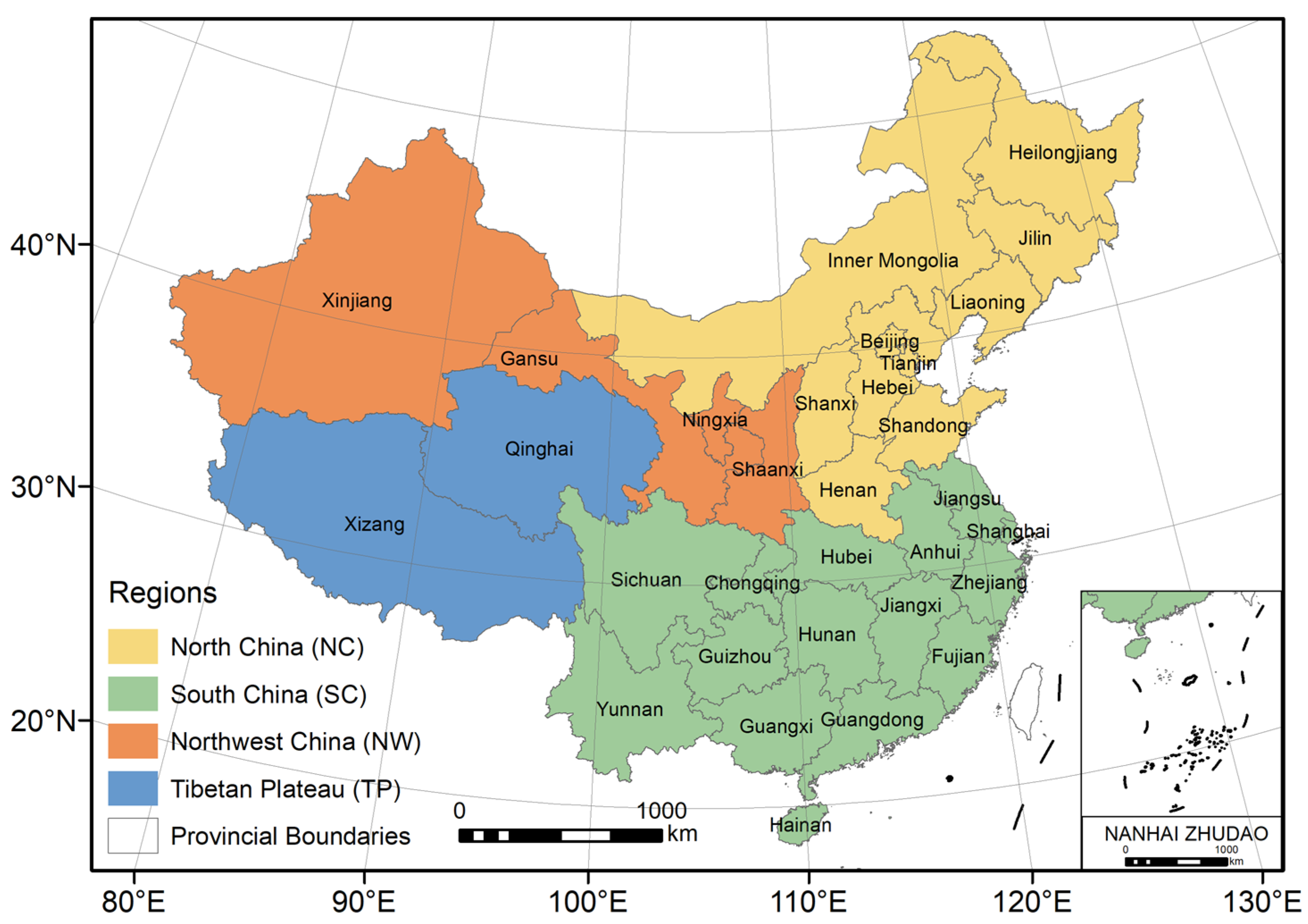
2.1. Data Used and Pre-Processing
2.1.1. Population Data
- (1)
- GPWv4 data
- (2)
- LandScan data
- (3)
- WorldPop data
- (4)
- China gridded population (CASpop) data
- (5)
- Population census data
2.1.2. Geographic and Economic Data
- (1)
- China county boundaries
- (2)
- Land-cover data
- (3)
- Digital elevation data
- (4)
- Economic data
2.2. Methodology
2.2.1. Accuracy Assessment of Population Datasets
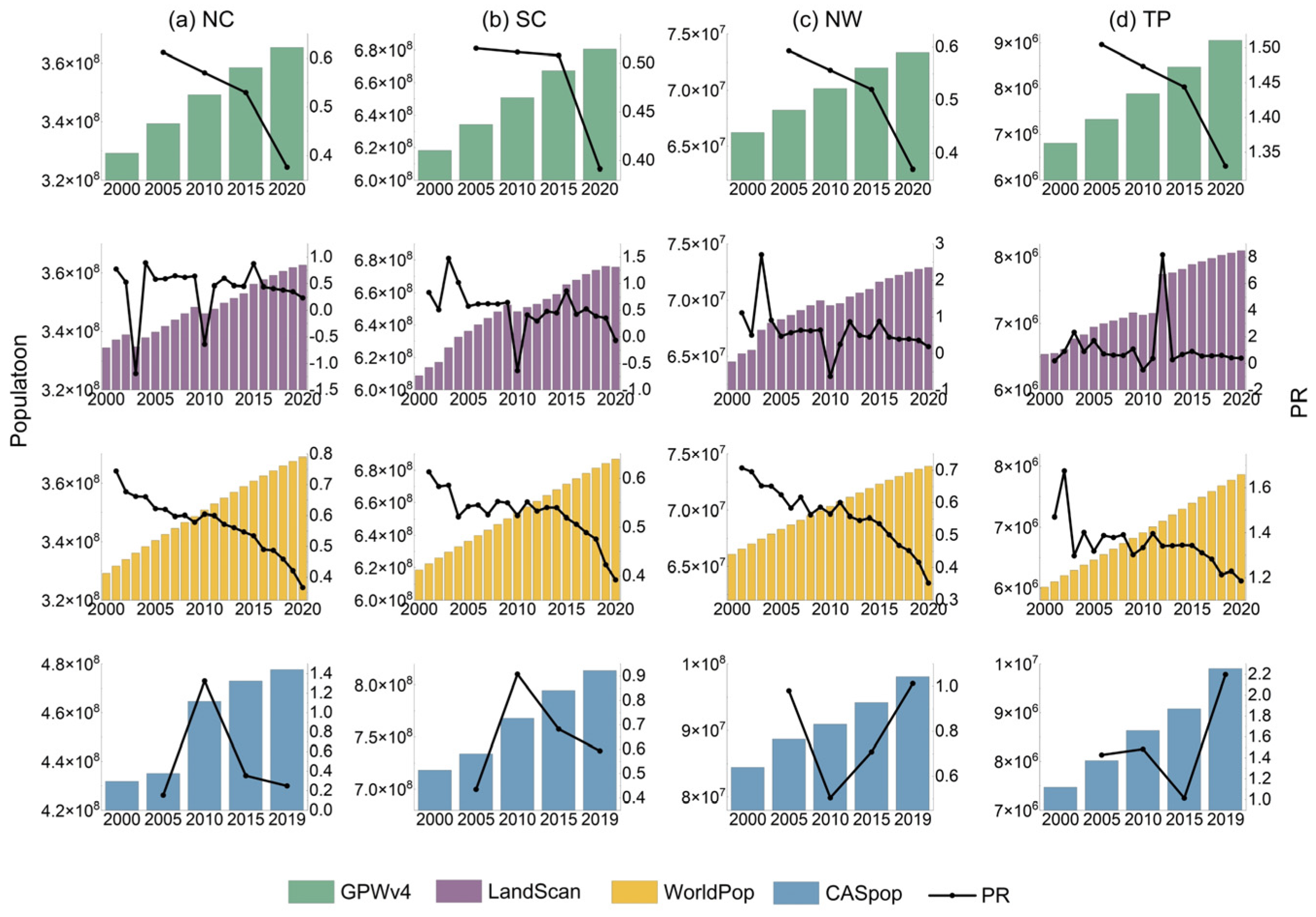
2.2.2. Analysis of Population Dynamics
- (1)
- Average annual growth rate of population (PAG)
- (2)
- Mann–Kendall trend analysis
2.2.3. Assessment of the Built-Up Land Dynamics
- (1)
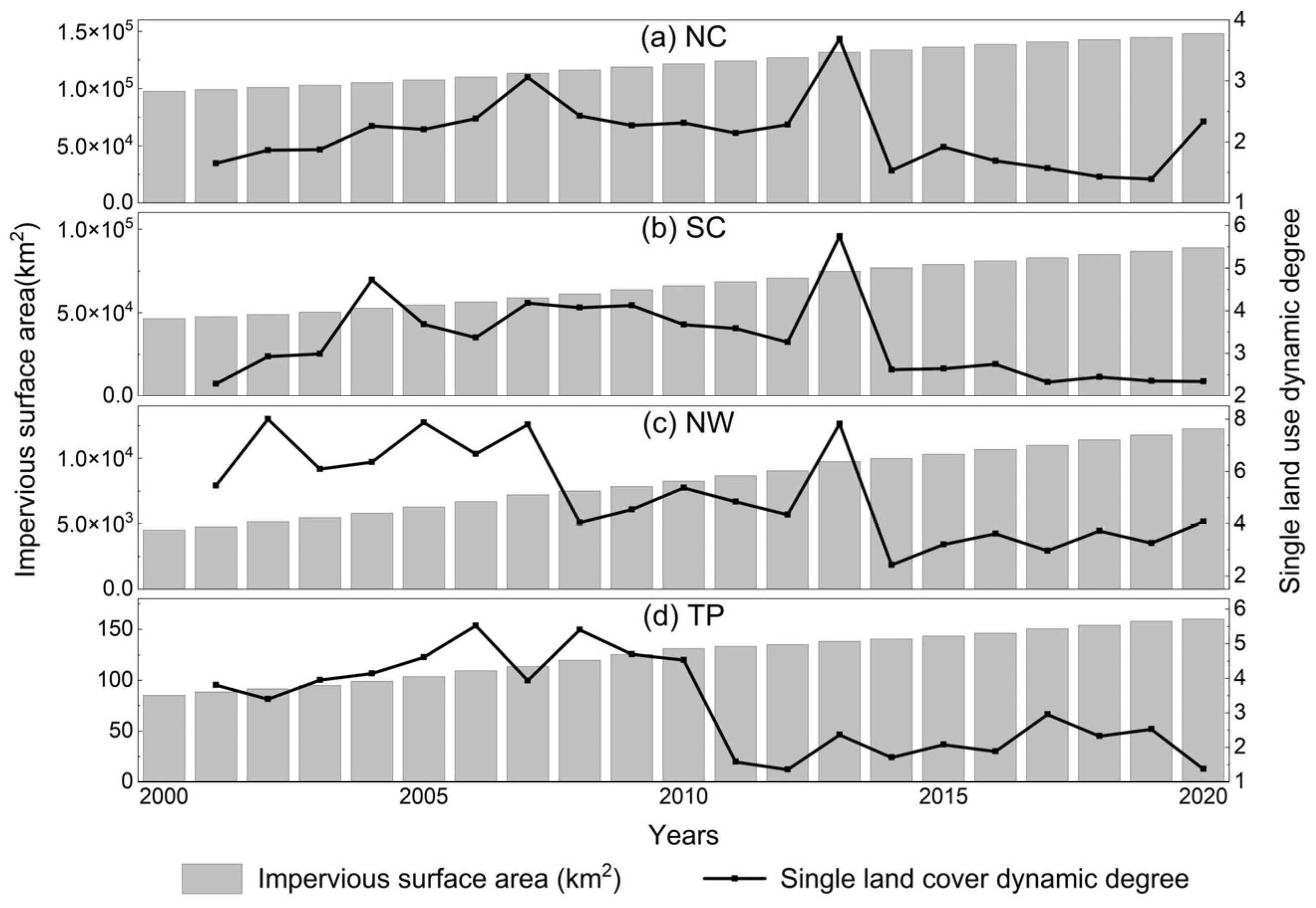
- The dynamic degree of a land-cover type
- (2)
- Built-up land expansion differentiation index
2.2.4. Approach to Measuring Human–Land Coordination Dynamics
- (1)
- The human–land elastic coefficient (HLEC)
- (2)
- The change rate of the built-up area per capita
2.2.5. Calculation of Topographic Relief
3. Results
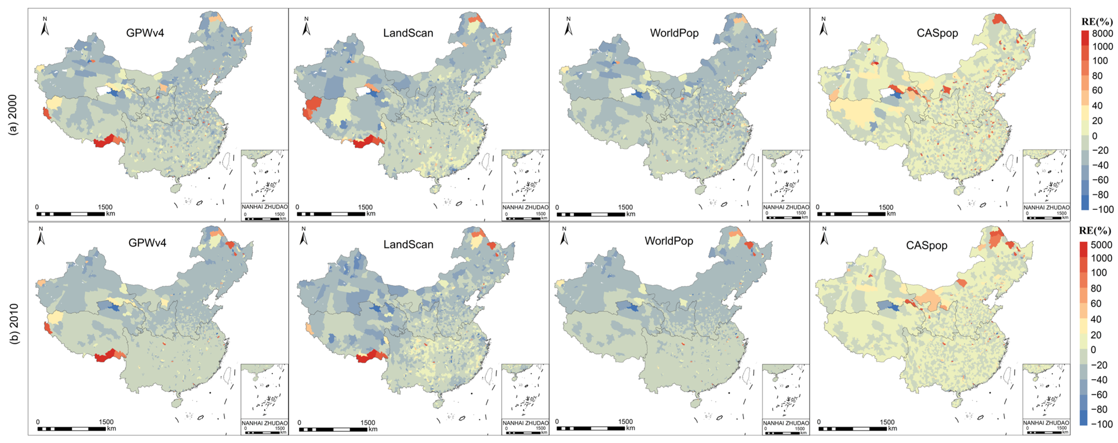
3.1. Accuracy Assessment of Population Datasets
3.2. Spatial and Temporal Characteristics of Population Evolution
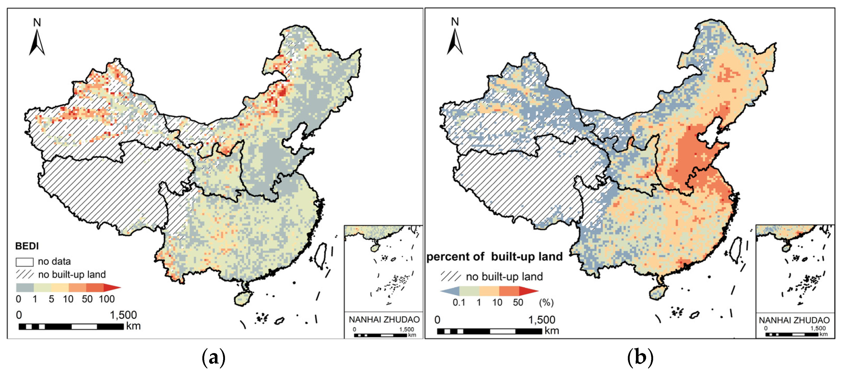
3.3. Spatiotemporal Changes of Built-Up Land
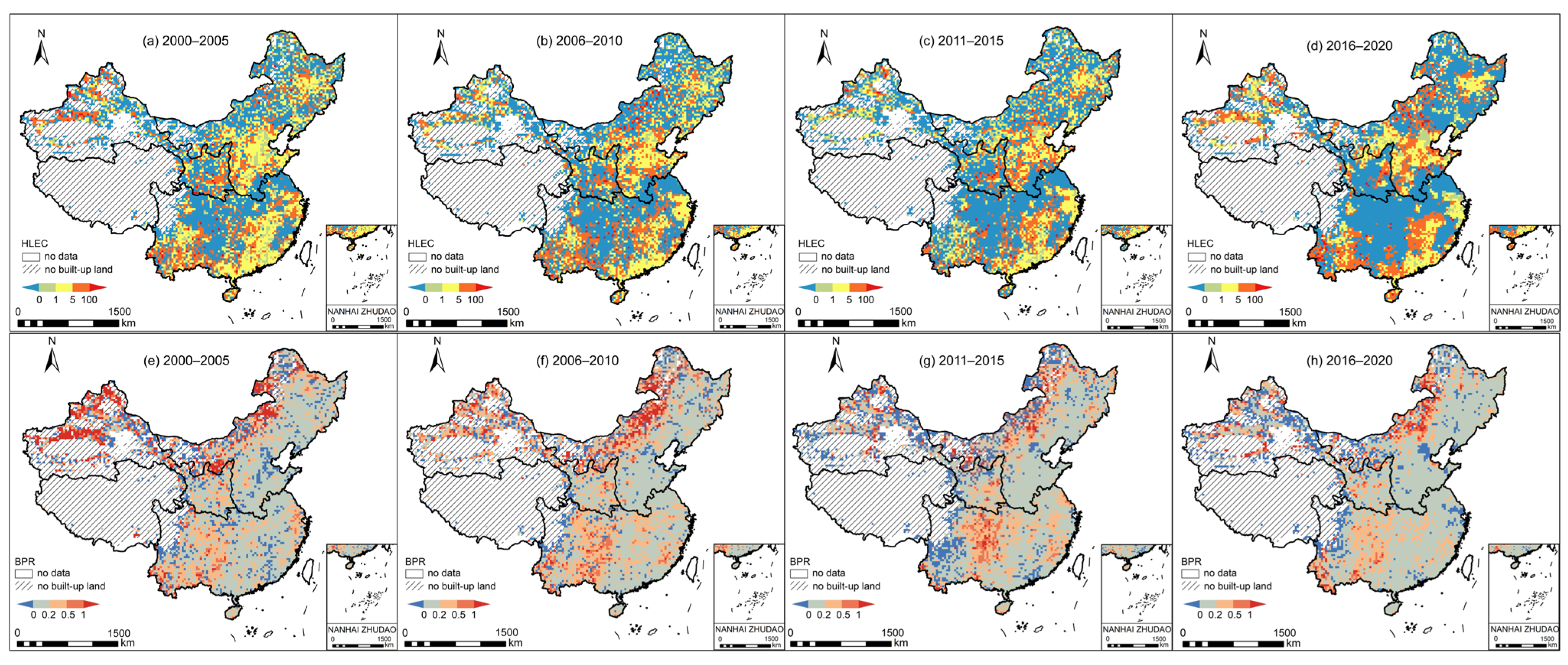
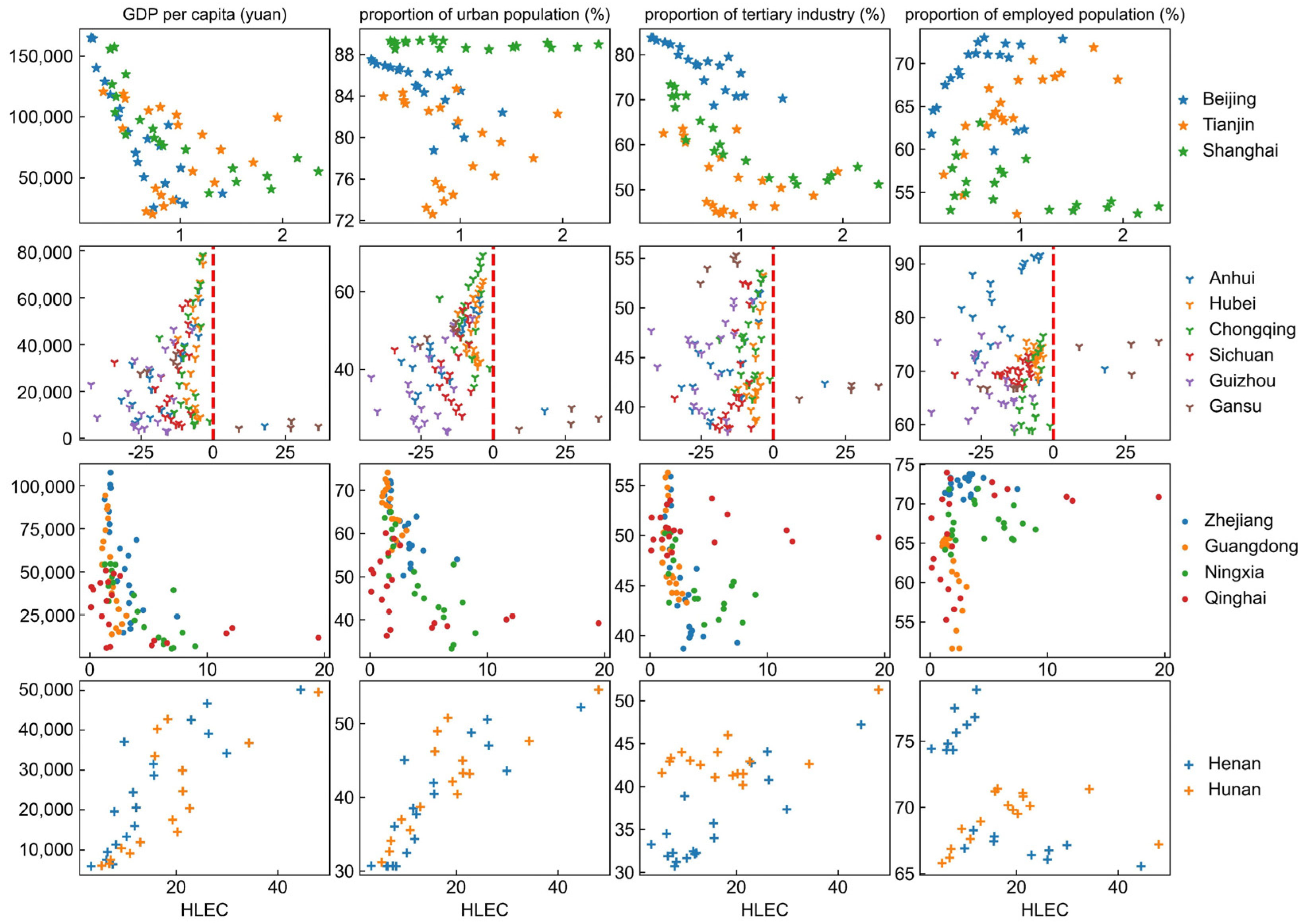
3.4. Human–Land Coordination Dynamics and Its Relationship with Economy Development
3.5. The Controls of Human–Land Relationship
4. Discussions
4.1. Comparison of Methods for Evaluating Human–Land Relationship
4.2. Reasons for the Changing Dynamics of Human–Land Relationships in China
5. Conclusions
Author Contributions
Funding
Institutional Review Board Statement
Informed Consent Statement
Data Availability Statement
Acknowledgments
Conflicts of Interest
References
- Fan, Y.; Fang, C.; Zhang, Q. Coupling Coordinated Development between Social Economy and Ecological Environment in Chinese Provincial Capital Cities-Assessment and Policy Implications. J. Clean. Prod. 2019, 229, 289–298. [Google Scholar] [CrossRef]
- Li, W.; Yi, P. Assessment of City Sustainability—Coupling Coordinated Development among Economy, Society and Environment. J. Clean. Prod. 2020, 256, 120453. [Google Scholar] [CrossRef]
- Oullier, O.; Kelso, J.A.S. Social Coordination, from the Perspective of Coordination Dynamics. In Encyclopedia of Complexity and Systems Science; Meyers, R.A., Ed.; Springer: New York, NY, USA, 2009; pp. 8198–8213. ISBN 978-0-387-75888-6. [Google Scholar]
- UN DESA (United Nations Department of Economic and Social Affairs). Global Population Growth and Sustainable Development; UN DESA/POP/2021/TR/NO. 2; UN DESA: New York, NY, USA, 2021. [Google Scholar]
- de Sherbinin, A.; Carr, D.; Cassels, S.; Jiang, L. Population and Environment. Annu. Rev. Environ. Resour. 2007, 32, 345–373. [Google Scholar] [CrossRef] [PubMed]
- Ouedraogo, I.; Tigabu, M.; Savadogo, P.; Compaoré, H.; Odén, P.C.; Ouadba, J.M. Land Cover Change and Its Relation with Population Dynamics in Burkina Faso, West Africa: Land cover change in burkina faso. Land Degrad. Dev. 2010, 21, 453–462. [Google Scholar] [CrossRef]
- Şen, G.; Güngör, E.; Şevik, H. Defining the Effects of Urban Expansion on Land Use/Cover Change: A Case Study in Kastamonu, Turkey. Environ. Monit. Assess 2018, 190, 454. [Google Scholar] [CrossRef] [PubMed]
- Tendaupenyu, P.; Magadza, C.H.D.; Murwira, A. Changes in Landuse/Landcover Patterns and Human Population Growth in the Lake Chivero Catchment, Zimbabwe. Geocarto Int. 2017, 32, 797–811. [Google Scholar] [CrossRef]
- Liang, L.; Chen, M.; Luo, X.; Xian, Y. Changes Pattern in the Population and Economic Gravity Centers since the Reform and Opening up in China: The Widening Gaps between the South and North. J. Clean. Prod. 2021, 310, 127379. [Google Scholar] [CrossRef]
- Li, G.; Sun, S.; Fang, C. The Varying Driving Forces of Urban Expansion in China: Insights from a Spatial-Temporal Analysis. Landsc. Urban Plan. 2018, 174, 63–77. [Google Scholar] [CrossRef]
- National Bureau of Statistics of China. China Statistical Yearbook; China Statistics Press: Beijing, China, 2021.
- Carter, R.C.; Parker, A. Climate Change, Population Trends and Groundwater in Africa. Hydrol. Sci. J. 2009, 54, 676–689. [Google Scholar] [CrossRef]
- Li, K.; Fang, L.; He, L. How Population and Energy Price Affect China’s Environmental Pollution? Energy Policy 2019, 129, 386–396. [Google Scholar] [CrossRef]
- Molotoks, A.; Smith, P.; Dawson, T.P. Impacts of Land Use, Population, and Climate Change on Global Food Security. Food Energy Secur. 2021, 10, e261. [Google Scholar] [CrossRef]
- Li, Y.; Kong, X.; Zhu, Z. Multiscale Analysis of the Correlation Patterns between the Urban Population and Construction Land in China. Sustain. Cities Soc. 2020, 61, 102326. [Google Scholar] [CrossRef]
- Liu, S.; Liao, Q.; Liang, Y.; Li, Z.; Huang, C. Spatio–Temporal Heterogeneity of Urban Expansion and Population Growth in China. Int. J. Environ. Res. Public Health 2021, 18, 13031. [Google Scholar] [CrossRef]
- Wang, Y.; Li, B. The Spatial Disparities of Land-Use Efficiency in Mainland China from 2000 to 2015. Int. J. Environ. Res. Public Health 2022, 19, 9982. [Google Scholar] [CrossRef] [PubMed]
- Tapio, P. Towards a Theory of Decoupling: Degrees of Decoupling in the EU and the Case of Road Traffic in Finland between 1970 and 2001. Transp. Policy 2005, 12, 137–151. [Google Scholar] [CrossRef]
- Adhikari, P.; de Beurs, K.M. Growth in Urban Extent and Allometric Analysis of West African Cities. J. Land Use Sci. 2017, 12, 105–124. [Google Scholar] [CrossRef]
- Lv, T.; Wang, L.; Zhang, X.; Xie, H.; Lu, H.; Li, H.; Liu, W.; Zhang, Y. Coupling Coordinated Development and Exploring Its Influencing Factors in Nanchang, China: From the Perspectives of Land Urbanization and Population Urbanization. Land 2019, 8, 178. [Google Scholar] [CrossRef]
- Shan, L.; Jiang, Y.; Liu, C.; Wang, Y.; Zhang, G.; Cui, X.; Li, F. Exploring the Multi-Dimensional Coordination Relationship between Population Urbanization and Land Urbanization Based on the MDCE Model: A Case Study of the Yangtze River Economic Belt, China. PLoS ONE 2021, 16, e0253898. [Google Scholar] [CrossRef]
- Li, Z.; Luan, W.; Zhang, Z.; Su, M. Relationship between Urban Construction Land Expansion and Population/Economic Growth in Liaoning Province, China. Land Use Policy 2020, 99, 105022. [Google Scholar] [CrossRef]
- Liu, Z.; Liu, S.; Jin, H.; Qi, W. Rural Population Change in China: Spatial Differences, Driving Forces and Policy Implications. J. Rural Stud. 2017, 51, 189–197. [Google Scholar] [CrossRef]
- Liu, T.; Peng, R.; Zhuo, Y.; Cao, G. China’s Changing Population Distribution and Influencing Factors: Insights from the 2020 Census Data. Acta Geogr. Sin. 2022, 77, 381–394. (In Chinese) [Google Scholar]
- Zhou, Y.; Li, X.; Liu, Y. Land Use Change and Driving Factors in Rural China during the Period 1995–2015. Land Use Policy 2020, 99, 105048. [Google Scholar] [CrossRef]
- Kuang, W.; Chi, W.; Lu, D.; Dou, Y. A Comparative Analysis of Megacity Expansions in China and the U.S.: Patterns, Rates and Driving Forces. Landsc. Urban Plan. 2014, 132, 121–135. [Google Scholar] [CrossRef]
- Dong, Y.; Ren, Z.; Fu, Y.; Miao, Z.; Yang, R.; Sun, Y.; He, X. Recording Urban Land Dynamic and Its Effects during 2000–2019 at 15-m Resolution by Cloud Computing with Landsat Series. Remote Sens. 2020, 12, 2451. [Google Scholar] [CrossRef]
- Zhang, T. Land Market Forces and Government’s Role in Sprawl: The Case of China. Cities 2000, 17, 123–135. [Google Scholar] [CrossRef]
- Yew, C.P. Pseudo-Urbanization? Competitive Government Behavior and Urban Sprawl in China. J. Contemp. China 2012, 21, 281–298. [Google Scholar] [CrossRef]
- Zhu, X.; Yao, D.; Shi, H.; Qu, K.; Tang, Y.; Zhao, K. The Evolution Mode and Driving Mechanisms of the Relationship between Construction Land Use and Permanent Population in Urban and Rural Contexts: Evidence from China’s Land Survey. Land 2022, 11, 1721. [Google Scholar] [CrossRef]
- Luo, J.; Xing, X.; Wu, Y.; Zhang, W.; Chen, R.S. Spatio-Temporal Analysis on Built-up Land Expansion and Population Growth in the Yangtze River Delta Region, China: From a Coordination Perspective. Appl. Geogr. 2018, 96, 98–108. [Google Scholar] [CrossRef]
- Wang, H.; Zhu, Y.; Huang, W.; Yin, J.; Niu, J. Spatio-Temporal Evolution and Driving Mechanisms of Rural Residentials from the Perspective of the Human-Land Relationship: A Case Study from Luoyang, China. Land 2022, 11, 1216. [Google Scholar] [CrossRef]
- Deichmann, U.; Balk, D.; Yetman, G. Transforming Population Data for Interdisciplinary Usages: From Census to Grid. Popul. Health Metr. Popul. Health Metr. 2001, 200. Available online: http://sedac.ciesin.columbia.edu/downloads/docs/gpw-v3/gpwdocumentation.pdf (accessed on 7 June 2022).
- Balk, D.L.; Deichmann, U.; Yetman, G.; Pozzi, F.; Hay, S.I.; Nelson, A. Determining Global Population Distribution: Methods, Applications and Data. In Advances in Parasitology; Elsevier: Amsterdam, The Netherlands, 2006; Volume 62, pp. 119–156. ISBN 978-0-12-031762-2. [Google Scholar]
- Pesaresi, M.; Ehrlich, D.; Stefano, F.; Aneta, J.F. Operating Procedure for the Production of the Global Human Settlement Layer from Landsat Data of the Epochs 1975, 1990, 2000, and 2014; Publications Office of the European Union: Luxembourg, 2016. [Google Scholar]
- Klein Goldewijk, K.; Beusen, A.; Doelman, J.; Stehfest, E. New Anthropogenic Land Use Estimates for the Holocene; HYDE 3.2. J. Earth Syst. Sci. Data Discuss 2016, 10. [Google Scholar] [CrossRef]
- Dobson, J.E.; Bright, E.A.; Coleman, P.R.; Durfee, R.C. LandScan: A Global Population Database for Estimating Populations at Risk. Photogramm. Eng. Remote Sens. 2000, 7, 849–857. [Google Scholar]
- Tatem, A.J. WorldPop, Open Data for Spatial Demography. Sci Data 2017, 4, 170004. [Google Scholar] [CrossRef] [PubMed]
- Yin, X.; Li, P.; Feng, Z.; Yang, Y.; You, Z.; Xiao, C. Which Gridded Population Data Product Is Better? Evidences from Mainland Southeast Asia (MSEA). IJGI 2021, 10, 681. [Google Scholar] [CrossRef]
- Archila Bustos, M.F.; Hall, O.; Niedomysl, T.; Ernstson, U. A Pixel Level Evaluation of Five Multitemporal Global Gridded Population Datasets: A Case Study in Sweden, 1990–2015. Popul. Environ. 2020, 42, 255–277. [Google Scholar] [CrossRef]
- Yang, J.; Huang, X. The 30 m Annual Land Cover Dataset and Its Dynamics in China from 1990 to 2019. Earth Syst. Sci. Data 2021, 13, 3907–3925. [Google Scholar] [CrossRef]
- Gong, P.; Wang, J.; Yu, L.; Zhao, Y.; Zhao, Y.; Liang, L.; Niu, Z.; Huang, X.; Fu, H.; Liu, S.; et al. Finer Resolution Observation and Monitoring of Global Land Cover: First Mapping Results with Landsat TM and ETM+ Data. Int. J. Remote Sens. 2013, 34, 2607–2654. [Google Scholar] [CrossRef]
- Mann, H.B. Nonparametric Tests Against Trend. Econometrica 1945, 13, 245. [Google Scholar] [CrossRef]
- Hirsch, R.M.; Slack, J.R.; Smith, R.A. Techniques of Trend Analysis for Monthly Water Quality Data. Water Resour. Res. 1982, 18, 107–121. [Google Scholar] [CrossRef]
- Wang, X.; Bao, Y. Study on the methods of land use dynamic change research. Prog. Geogr. 1999, 18, 83–89. (In Chinese) [Google Scholar]
- Zhu, H.; Li, X.; He, S.; Zhang, M. Spatio-temporal Change of Land Use in Bohai Rim. Acta Geogr. Sin. 2001, 56, 253–260. (In Chinese) [Google Scholar]
- Bekhet, H.A. Assessing the Elasticities of Electricity Consumption for Rural and Urban Areas in Malaysia: A Non-Linear Approach. Int. J. Econ. Financ. 2011, 3, 208–217. [Google Scholar] [CrossRef]
- Ma, P.-F.; Wu, D.-F.; Lin, T.; Wu, Z.-J.; Li, Z.-C.; Liang, Y.-X.; Zhang, Y.-C.; Lai, H.-M. Spatio-Temporal Coupling Relationship between Rural Population and Cultivated Land Changes at the County Level in Guangdong Province. Sustainability 2022, 14, 14929. [Google Scholar] [CrossRef]
- Cai, E.; Chen, W.; Wei, H.; Li, J.; Wang, H.; Guo, Y.; Feng, X. The Coupling Characteristics of Population and Residential Land in Rural Areas of China and Its Implications for Sustainable Land Use. Sustain. Dev. 2020, 28, 646–656. [Google Scholar] [CrossRef]
- Camagni, R.; Gibelli, M.C.; Rigamonti, P. Urban Mobility and Urban Form: The Social and Environmental Costs of Different Patterns of Urban Expansion. Ecol. Econ. 2002, 40, 199–216. [Google Scholar] [CrossRef]
- Corbane, C.; Politis, P.; Siragusa, A.; Kemper, T.; Pesaresi, M. LUE User Guide: A Tool to Calculate the Land Use Efficiency and the SDG 11.3 Indicator with the Global Human Settlement Layer; Publications Office of the European Union: Luxembourg, 2017; ISBN 978-92-79-73631-5. [Google Scholar]
- Nicolau, R.; David, J.; Caetano, M.; Pereira, J. Ratio of Land Consumption Rate to Population Growth Rate—Analysis of Different Formulations Applied to Mainland Portugal. IJGI 2018, 8, 10. [Google Scholar] [CrossRef]
- Deffontaines, B.; Lee, J.-C.; Angelier, J.; Carvalho, J.; Rudant, J.-P. New Geomorphic Data on the Active Taiwan Orogen: A Multisource Approach. J. Geophys. Res. 1994, 99, 20243–20266. [Google Scholar] [CrossRef]
- Zhang, W.; Li, A. Study on the Optimal Scale for Calculating the Relief Amplitude in China Based on DEM. Geogr. Geo-Inf. Sci. 2012, 28, 8–12. (In Chinese) [Google Scholar]
- CIESIN (Center for International Earth Science Information Network), Columbia University. Documentation for the Gridded Population of the World; Version 4 (GPWv4), Revision 11 Data Sets; NASA Socioeconomic Data and Applications Center (SEDAC): Palisades, NY, USA, 2018. [Google Scholar] [CrossRef]
- Lloyd, C.T.; Sorichetta, A.; Tatem, A.J. High Resolution Global Gridded Data for Use in Population Studies. Sci Data 2017, 4, 170001. [Google Scholar] [CrossRef]
- Bai, Z.; Wang, J.; Wang, M.; Gao, M.; Sun, J. Accuracy Assessment of Multi-Source Gridded Population Distribution Datasets in China. Sustainability 2018, 10, 1363. [Google Scholar] [CrossRef]
- Lin, D.; Tan, M.; Liu, K.; Liu, L.; Zhu, Y. Accuracy Comparison of Four Gridded Population Datasets in Guangdong Province, China. Trop. Geogr. 2020, 40, 346–356. [Google Scholar] [CrossRef]
- Xu, Y.; Ho, H.C.; Knudby, A.; He, M. Comparative Assessment of Gridded Population Data Sets for Complex Topography: A Study of Southwest China. Popul. Environ. 2021, 42, 360–378. [Google Scholar] [CrossRef]
- Kuang, W.; Liu, J.; Zhang, Z.; Lu, D.; Xiang, B. Spatiotemporal Dynamics of Impervious Surface Areas across China during the Early 21st Century. Chin. Sci. Bull. 2013, 58, 1691–1701. [Google Scholar] [CrossRef]
- Song, Q.; Zhou, N.; Liu, T.; Siehr, S.A.; Qi, Y. Investigation of a “Coupling Model” of Coordination between Low-Carbon Development and Urbanization in China. Energy Policy 2018, 121, 346–354. [Google Scholar] [CrossRef]
- UNGA (United Nations General Assembly). Transforming Our World: The 2030 Agenda for Sustainable Development; A/RES/70/1; United Nations: New York, NY, USA, 2015. [Google Scholar]
- UN-Habitat Sustainable Development Goal 11+ Make Cities and Human Settlements Inclusive, Safe, Resilient and Sustainable: A Guide to Assist National and Local Governments to Monitor and Report on SDG Goal 11+ Indicators. Monitoring Framework—Definitions—Metadata—UN-Habitat Technical Support. 2018. Available online: https://smartnet.niua.org/sites/default/files/resources/sdg_goal_11_monitoring_framework.pdf (accessed on 15 June 2023).
- Huang, Z.; Du, X. Urban Land Expansion and Air Pollution: Evidence from China. J. Urban Plann. Dev. 2018, 144, 05018017. [Google Scholar] [CrossRef]
- Zhang, X.; Chi, T. Differentiating and analysis of the coordination degree between economic development and environment of provinces(regions) in China. Geogr. Res. 2001, 506–515. (In Chinese) [Google Scholar]
- Estoque, R.C.; Ooba, M.; Togawa, T.; Hijioka, Y.; Murayama, Y. Monitoring Global Land-Use Efficiency in the Context of the UN 2030 Agenda for Sustainable Development. Habitat Int. 2021, 115, 102403. [Google Scholar] [CrossRef]
- Lin, Y.; Mao, L. Urban Land Expansion and Land Use Intensification in China. Territ. Nat. Resour. Study 2008, 3, 27–29. (In Chinese) [Google Scholar]
- Zhu, F.; Zhang, F.; Li, C.; Jiao, P.; Wang, J. Coordination and regional difference of urban land expansion and demographic urbanization in China during 1993–2008. Prog. Geogr. 2014, 33, 647–656. (In Chinese) [Google Scholar]
- Liu, J.; Liu, Y.; Li, Y.; Hu, Y. Coupling Analysis of Rural Residential Land and Rural Population in China during 2007–2015. J. Nat. Resour. 2018, 33, 1861–1871. (In Chinese) [Google Scholar]
- UK Office for National Statistics Using Innovative Methods to Report Against the Sustainable Development Goals. Available online: https://www.ons.gov.uk/economy/environmentalaccounts/articles/usinginnovativemethodstoreportagainstthesustainabledevelopmentgoals/2018-10-22 (accessed on 16 June 2023).
- Schiavina, M.; Melchiorri, M.; Corbane, C.; Florczyk, A.; Freire, S.; Pesaresi, M.; Kemper, T. Multi-Scale Estimation of Land Use Efficiency (SDG 11.3.1) across 25 Years Using Global Open and Free Data. Sustainability 2019, 11, 5674. [Google Scholar] [CrossRef]
- Wang, Y.; Huang, C.; Feng, Y.; Zhao, M.; Gu, J. Using Earth Observation for Monitoring SDG 11.3.1-Ratio of Land Consumption Rate to Population Growth Rate in Mainland China. Remote Sens. 2020, 12, 357. [Google Scholar] [CrossRef]
- Jin, L.; Wang, Z.; Chen, X. Spatial Distribution Characteristics and Influencing Factors of Traditional Villages on the Tibetan Plateau in China. Int. J. Environ. Res. Public Health 2022, 19, 13170. [Google Scholar] [CrossRef] [PubMed]
- Du, Y.; Yang, C. Demographic Transition and Labour Market Changes: Implications for Economic Development in China. J. Econ. Surv. 2014, 28, 617–635. [Google Scholar] [CrossRef]
- Qiao, L.; Li, Y.; Liu, Y.; Yang, R. The Spatio-Temporal Change of China’s Net Floating Population at County Scale from 2000 to 2010: Change Features of China’s Floating Population. Asia Pac. Viewp. 2016, 57, 365–378. [Google Scholar] [CrossRef]
- Liang, Z.; Li, Z.; Ma, Z. Changing Patterns of the Floating Population in China, 2000–2010. Popul. Dev. Rev 2014, 40, 695–716. [Google Scholar] [CrossRef] [PubMed]
- Deng, Y.; Qi, W.; Fu, B.; Wang, K. Geographical Transformations of Urban Sprawl: Exploring the Spatial Heterogeneity across Cities in China 1992–2015. Cities 2020, 105, 102415. [Google Scholar] [CrossRef]
- Qi, Y.; Yang, Y.; Jin, F. China’s Economic Development Stage and Its Spatio-Temporal Evolution: A Prefectural-Level Analysis. J. Geogr. Sci. 2013, 23, 297–314. [Google Scholar] [CrossRef]
- Wang, J.; Lin, Y.; Glendinning, A.; Xu, Y. Land-Use Changes and Land Policies Evolution in China’s Urbanization Processes. Land Use Policy 2018, 75, 375–387. [Google Scholar] [CrossRef]


| GPWv4 | LandScan | WorldPop | CASpop | |
|---|---|---|---|---|
| Versions | UN WPP-Adjusted Population Count, v4.11 | / | Unconstrained individual countries 2000–2020 UN adjusted | / |
| Producing agency | CIESIN, Columbia University | Oak Ridge National Laboratory | University of Southampton | Chinese Academy of Sciences |
| Temporal coverage | 2000, 2005, 2010, 2015, 2020 | 2000–2020 | 2000–2020 | 1990, 1995, 2000, 2005, 2010, 2015, 2019 |
| Spatial resolution | 30 arc-seconds | 30 arc-seconds | 30 arc-seconds | 1 km |
| Methodology | area weighting | dasymetric mapping | random forest | multi-factor weighting |
| Auxiliary data | water masks | road network, slope, land cover, nighttime light data | land cover, digital elevation data, slope, net primary productivity, nighttime light data, etc. | land cover, nighttime light data, settlement density, etc. |
| τ | p-Value | Trend Category (Z Value) | Trend Characteristics |
|---|---|---|---|
| p ≤ 0.01 | 3 | Extremely significant increase | |
| 0.01 < p ≤ 0.05 | 2 | Significant increase | |
| 0.05 < p ≤ 0.1 | 1 | Slight increase | |
| p > 0.1 | 0 | No change | |
| 0.05 < p ≤ 0.1 | −1 | Slight decrease | |
| 0.01 < p ≤ 0.05 | −2 | Significant decrease | |
| p ≤ 0.01 | −3 | Extremely significant decrease |
| Categories | HLEC | BPR | Description | |||
|---|---|---|---|---|---|---|
| BR | PR | Relationship between the BR and PR | Coordination Status | |||
| 1 | HLEC > 1 | >0 | + | + | BR > PR | Uncoordinated |
| 2 | <0 | − | − | BR < PR | ||
| 3 | 0 < HLEC < 1 | <0 | + | + | BR < PR | Coordinated |
| 4 | >0 | − | − | BR > PR | ||
| 5 | HLEC < 0 | >0 | + | − | BR > PR | Uncoordinated |
| 6 | <0 | − | + | BR < PR | ||
| 7 | HLEC = 0 | >0 | / | − | BR > PR | Uncoordinated |
| 8 | <0 | / | + | BR < PR | ||
| 9 | HLEC = 1 | =0 | / | / | BR = PR | Coordinated |
| 10 | / | ± | ± | 0 | / | Uncoordinated |
| 2000 | 2010 | |||||
|---|---|---|---|---|---|---|
| r | RMSE (Person) | MBE (Person) | r | RMSE (Person) | MBE (Person) | |
| GPWv4 | 0.960 | 130,954 | −15.2 | 0.887 | 232,953 | −16.2 |
| LandScan | 0.907 | 176,829 | −15.4 | 0.847 | 264,578 | −15.7 |
| WorldPop | 0.960 | 131,260 | −17.4 | 0.889 | 231,097 | −18.6 |
| CASpop | 0.941 | 125,122 | 6.6 | 0.888 | 204,474 | 2.5 |
Disclaimer/Publisher’s Note: The statements, opinions and data contained in all publications are solely those of the individual author(s) and contributor(s) and not of MDPI and/or the editor(s). MDPI and/or the editor(s) disclaim responsibility for any injury to people or property resulting from any ideas, methods, instructions or products referred to in the content. |
© 2023 by the authors. Licensee MDPI, Basel, Switzerland. This article is an open access article distributed under the terms and conditions of the Creative Commons Attribution (CC BY) license (https://creativecommons.org/licenses/by/4.0/).
Share and Cite
Zhao, T.; Wang, W. Coordination Dynamics between Population Change and Built-Up Land Expansion in Mainland China during 2000–2020. Sustainability 2023, 15, 16059. https://doi.org/10.3390/su152216059
Zhao T, Wang W. Coordination Dynamics between Population Change and Built-Up Land Expansion in Mainland China during 2000–2020. Sustainability. 2023; 15(22):16059. https://doi.org/10.3390/su152216059
Chicago/Turabian StyleZhao, Tianqing, and Wen Wang. 2023. "Coordination Dynamics between Population Change and Built-Up Land Expansion in Mainland China during 2000–2020" Sustainability 15, no. 22: 16059. https://doi.org/10.3390/su152216059
APA StyleZhao, T., & Wang, W. (2023). Coordination Dynamics between Population Change and Built-Up Land Expansion in Mainland China during 2000–2020. Sustainability, 15(22), 16059. https://doi.org/10.3390/su152216059