1. Introduction
Industrial sites are essential for the development of an area and they are even more crucial considering the increasing population, which results in an increasing demand for the supply of industrial products. The procurement of products requires a particular place, specifically set as an industrial site location, to produce different products that society needs. An industrial site is an area where industrial activities are centralized and supported by facilities and infrastructure that are developed and managed by industrial site companies with an industrial estate business license [
1]. The development of industrial sites requires a planning period of two to five years [
2], which serves as a medium for economic growth through the improvement of investment in the industrial sector.
The development of industrial sites in Indonesia has continuously been progressing and it has already reached an area of 52,438 hectares. There have been 112 industrial sites that have been actively operated, with 64 (57%) sites located on Java Island, while the rest are in Sumatera (37 sites), Kalimantan (8 sites), and Sulawesi (3 sites) [
3]. The industrial sites are still centralized on Java Island, so the government is making some effort to develop some new industrial sites outside the island to encourage inclusive economic equity.
An industrial site facilitates economic growth, increases the area’s per capita income [
4,
5,
6], and can attract foreign investors to invest in the site. The strategic decisions of an investor are influenced by performance criteria like workforce competencies, employee tariffs, geographical position, road infrastructure, material availability, licenses, and telecommunication infrastructure [
7]. In order to accelerate the development of industrial sites, the government has issued Government Regulation No. 142/2015 on Industrial Sites in Indonesia [
8] as part of its efforts to encourage industrial site competitiveness.
However, an increase in industrial site development may affect the availability and capacity of land and thus, any site development should consider how much land is needed for either settlement or agricultural production. Land-use suitability analyses can determine the usage of land, such as for farming, industry, settlement, and forest, to ensure well-balanced land usage for various public needs [
9,
10,
11].
There are different problems and obstacles in the development of an industrial site, including the ones related to document preparation, land and spatial planning, licensing, building the required infrastructure, management and tenant search, and business convenience creation [
12]. Therefore, a plan for industrial site development that takes different problems, risks, and criteria into account is required in order to establish a successful industrial site. Some considerations taken in this study are soil characteristics, risks, and the optimum distance between industrial site locations.
Industrial sites have a very important role in encouraging economic growth, creating jobs for the surrounding community, encouraging technology transfer, and sociology. But they can also have an impact on the geological environment that affects the environmental conditions before and after the existence of an industrial site.
The case study in this research is in West Java because it is a strategic area that is the location of the largest industrial site in Indonesia, with a total land area of 3,708,659.23 hectares. As of 2023, at least 32 industrial estates have spread across various regions in West Java. One of them is the Jababeka Industrial Estate, which is the largest industrial site in Southeast Asia [
13]. Therefore, West Java is quite important and relevant as a case study that can be used as a research model.
This paper aimed to scientifically contribute to (1) the development of a model used to determine sustainable industrial sites, (2) the assessment of the suitability of industrial site locations, and (3) the evaluation of existing industrial sites as well as the planned ones. The assessment and evaluation were conducted using a website-based geographical information system [
14]. The application makes the mapping and scoring of the suitability level of industrial site locations easy, and it can be accessed online under a certain set of criteria.
The new method of this research is to integrate the GIS and AHP approaches into a web-based geographic information system application that is used to easily support widespread assessment and mapping.
2. Literature Review
2.1. Soil Characteristics
In a general engineering sense, soil is defined as a granular aggregate of decaying granules of minerals and organic matter (solid particles) along with liquids and gases that occupy the empty spaces between solid particles. Soil is used as a construction material in various civil engineering projects to support structural foundations. Thus, civil engineers must study the properties of the soil, such as its origin, grain size distribution, ability to drain water, compressibility, shear strength, load-bearing capacity, and so on. Soil mechanics is a branch of science that deals with the study of the physical properties of soils and the behavior of soil masses when subjected to various types of forces [
15].
All soils contain mineral particles, organic matter, water, and air. The combination of these components determines the soil properties—texture, structure, porosity, chemistry, and color. The investigation and mapping of soil properties in identifying potential new industrial zones are in accordance with the objectives of land investigations, which include the following steps [
16].
- a.
Determining the suitability of the site for the proposed project.
- b.
Determining an adequate and economical foundation design.
- c.
Determining difficulties that may arise during the construction process and period.
- d.
Determining the events and/or causes of all changes in the soil conditions.
Consideration of the soil characteristics in industrial site planning is aimed at avoiding any risks of soil erosion in areas that can be dangerous for society. Both soil erosion and degradation are related to agriculture, soil fertility degradation, and negative environmental impacts [
17,
18,
19]. Landslides involve the downslope movement of soil, rocks, or debris due to gravity. It is a natural disaster that is harmful to humans and the environment [
20]. Soil characteristics are important to consider for maintaining industrial sites and preventing land, environmental, and ecosystem degradation.
2.2. Multi-Criteria Decision Making
Solving diverse problems typically involves various variables, and it is uncommon to consider only a single variable in the decision-making process. These variables possess distinct characteristics based on different criteria. Consequently, the inclusion of a greater number of decision-making criteria results in increased problem complexity. One structured approach for addressing complex problems is via the utilization of Multi-Criteria Decision Making (MCDM), wherein criteria are assigned weights to each variable, thereby facilitating the evaluation of different alternatives [
21].
To determine the sustainability of an industrial location, several criteria must be taken into consideration, such as geography, environment, infrastructure, technology, demography, access to the market, proximity to raw materials, and the availability of skilled workers. Developers, entrepreneurs, and investors select locations based on information, analysis, and decision-making processes that enable them to enhance their competitiveness [
22]. Conversely, industrial locations should be capable of attracting foreign investors by offering adequate facilities and infrastructure, thus ensuring efficient and effective production activities. Establishing a strategically advantageous industrial location is of paramount importance in attracting investors.
One of the methods employed to assign weights to the chosen criteria is the Analytic Hierarchy Process (AHP), which was originally introduced by Saaty [
23,
24]. AHP is a commonly employed technique for resolving MCDM problems. It serves as a robust and user-friendly tool for analyzing multi-criteria issues both qualitatively and quantitatively [
25,
26]. AHP serves as a valuable decision support tool for addressing complex decision-making problems.
2.3. Analytical Hierarchy Process (AHP)
The fusion of Geographic Information Systems (GIS) and AHP represents a contemporary trend in the assessment and analysis of soil suitability, particularly as an application of Multi-Criteria Decision Making (MCDM), with a particular emphasis on AHP and GIS [
27]. The integration of GIS and MCDM has proven highly effective in enhancing problem-solving capabilities in the context of complex spatial decision making [
28]. Numerous researchers have harnessed the synergy of these two methodologies to assess environmental issues and identify potential locations for soil and water conservation initiatives, particularly within watersheds [
29,
30]. The development of industrial sites can lead to adverse environmental impacts, including soil degradation, water pollution, and air pollution. Consequently, these aspects warrant careful consideration.
Hybrid approaches combining the Analytical Hierarchy Process (AHP) and GIS methodologies have been employed to evaluate land-use suitability for agricultural and pastureland in Iran [
31]. It is conceivable that the expansion of industrial zones may encroach upon agricultural and pasture areas. The determination of factors and variables used to assess industrial site suitability is accomplished by computing variable weights via the application of the AHP method [
32].
2.4. Geographical Information System (GIS)
Geographic Information Systems (GIS) have found widespread application in addressing various location-related challenges that involve the analysis of spatial data and geographical coordinates. GIS serves as a computerized system designed for the tasks of data capture, manipulation, input, visualization, combination, transformation, query, modeling, analysis, and output [
33]. Spatial analysis forms the cornerstone of data integration, enabling the amalgamation and collection of data across diverse spatial scales and temporal dimensions.
GIS serves a multitude of purposes, spanning from industrial site selection to telecommunications, transportation, emergency management, urban planning, and military applications, among others [
34]. Notably, GIS has been harnessed to assess landslide susceptibility, as exemplified in a case study conducted in China [
35]. The utilization of GIS in the determination of industrial locations has been extensively adopted [
36,
37,
38]. Furthermore, GIS is in a state of continuous development, and in addition to its application across various domains, it is dynamically advanced in a 4D framework, as demonstrated in a case study pertaining to public security [
39].
2.5. Industrial Site Impacts and Risks
In addition to contributing positively to economic growth via production activities, industrial sites also exert significant influences on the environment. These impacts, whether beneficial or adverse, must be given paramount consideration when determining the sustainability of industrial site locations. Particular attention should be devoted to mitigating adverse effects to prevent environmental harm. This approach is essential for averting any potential environmental damage. The concerns regarding industrial site accidents, especially those with the potential to harm the surrounding population, are elucidated in multiple studies [
40,
41,
42]. Furthermore, various risks that industrial sites should anticipate are expounded upon in a quantitative risk analysis study conducted in the industrial sector by Attia and Sinha [
43].
The process of clearing land for industrial site development has a noticeable impact on environmental conditions, both before and after the development takes place. It is crucial to exercise control over environmental degradation stemming from industrialization to prevent any hazardous consequences for society. Among the adverse effects of industrial site development that pose risks to the existing ecosystem are landslides, land degradation, and biodiversity depletion [
44,
45]. A comprehensive understanding of the environment, energy conservation, water management, waste handling, heat management, and pollution control is imperative for sustainable development [
46]. To mitigate these impacts, an assessment of various criteria within industrial sites is essential, considering a range of factors encompassing social, environmental, technical, and economic dimensions [
47].
3. Methodology
The methodology employed in this study integrates soil characteristics, existing regulations pertaining to industrial sites, distance considerations, and geographical information system (GIS). Soil characteristics, legal regulations, and distance factors were utilized to assess industrial site security and mitigate potential risk impacts. These variables were elaborated into specific criteria, and their weights were determined using the Analytic Hierarchy Process (AHP) method. The weighted variables and criteria were subsequently integrated into GIS for location assessment.
Soil characteristics encompass various soil types, including latosol, laterit, grumosol alluvial, brown forest soil, litosol podsol, regosol, mediterranean andosol, gleiplanosol, podsolik, organosol, rendzina [
48]. Additionally, the research model considers existing regulations and policies concerning industrial sites, such as those stipulated in the Regulation of the Minister of Industry No. 35/M-IND/PER/3/2010 on Technical Guidance for Industrial Sites [
49]. These regulations encompass various factors, including distance to the city center, distance to settlements, road network accessibility, topography, distance to rivers or clean water sources, land conditions, land availability, land pricing, location orientation, land-use patterns, and multiplier effects [
50].
The study incorporates six variables, namely (1) land slope, (2) land use, (3) land type, (4) distance to roads and access, (5) distance to rivers, and (6) distance to public facilities [
14].
A case study of this research was conducted by assessing industrial sites in West Java Province, Indonesia. The six research variables were evaluated using the AHP method. Pairwise comparisons were conducted to assign values between 1 and 9 to reflect the relative importance of each variable. This was used to calculate eigen factors. In the equations below, A represents an n × n matrix, w is an n-dimensional vector, and λ is the eigen vector:
The steps in the AHP method are generally as follows:
- i
Determining the variable used;
- ii
Normalization process;
- iii
Calculating the eigen value;
- iv
Calculating the consistency index (CI) and consistency ratio (CR);
- v
Testing the consistency of the hierarchy.
CI: Consistency Index/Consistency Deviation Ratio
λmax: Maximum Eigen Value
n: Matrix Size
The comparison of
CI and
RI for a matrix is defined as follows:
CR: Consistency Ratio
CI: Consistency Index
RI: Random Index
The results of the AHP method indicate that the Consistency Ratio (
CR) is 0.0872, and because
CR ≤ 0.1000, the results of the variable weighting are consistent [
14], as shown in
Table 1.
The data for the six variables were collected from West Java Province, Indonesia:
- i
Data on land slope: Obtained from the 2018 updated Indonesian Topographical Map by the Geospatial Information Agency in Shapefile (*.Shp) format.
- ii
Data on land use: Derived from the 2016 ONE MAP data by the Geospatial Information Agency in Shapefile (*.Shp) format.
- iii
Data on soil types: Obtained from the 2018 updated Indonesian Topographical Map by the Geospatial Information Agency in Shapefile (*.Shp) format.
- iv
Data on distance to roads and access: Collected from the 2018 Topographical Map data by the Geospatial Information Agency in Shapefile (*.Shp) format.
- v
Data on distance to rivers: Gathered from the 2018 Map of the Ministry of Health of the Republic of Indonesia, available from the Geospatial Information Agency in Shapefile (*.Shp) format.
- vi
Data on the distance to public facilities: Acquired from the 2018 Topographical Map data by the Geospatial Information Agency in Shapefile (*.Shp) format.
The scoring process involved multiplying the weight of each variable by the assessment score, normalized by multiplying by 100:
W = variable weight
k = variable characteristic
P = location assessment score
The location assessment score (P) is determined as follows:
Variable characteristics were assessed on a 5-point ordinal scale, ranging from 1 (unsuitable) to 5 (highly suitable) as follows:
1 = unsuitable
2 = marginally suitable
3 = moderately suitable
4 = suitable
5 = highly suitable
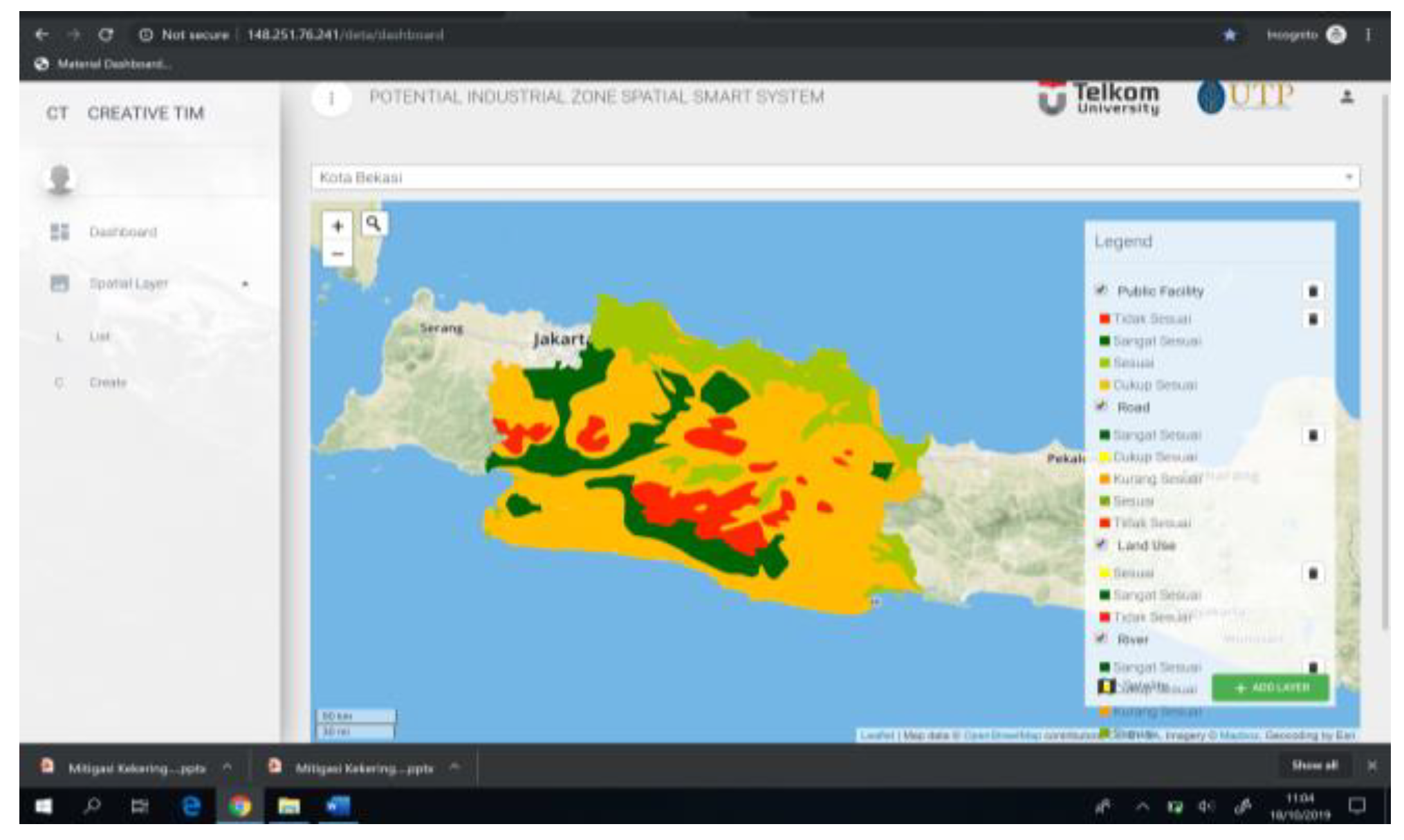
Data processing was performed using a web-based Geographical Information System (GIS) smart application to calculate scores at various points in West Java Province, Indonesia.
Figure 1 depicts the dashboard of the GIS application used for location assessment and mapping of industrial sites.
4. Result
The outcomes of the AHP method for weighting six variables, which include land slope, land use, soil type, distance from land to roads and access, distance from land to rivers, and distance from land to public facilities [
14], are presented in
Table 2.
4.1. Classifications Based on Soil Characteristics and Distance
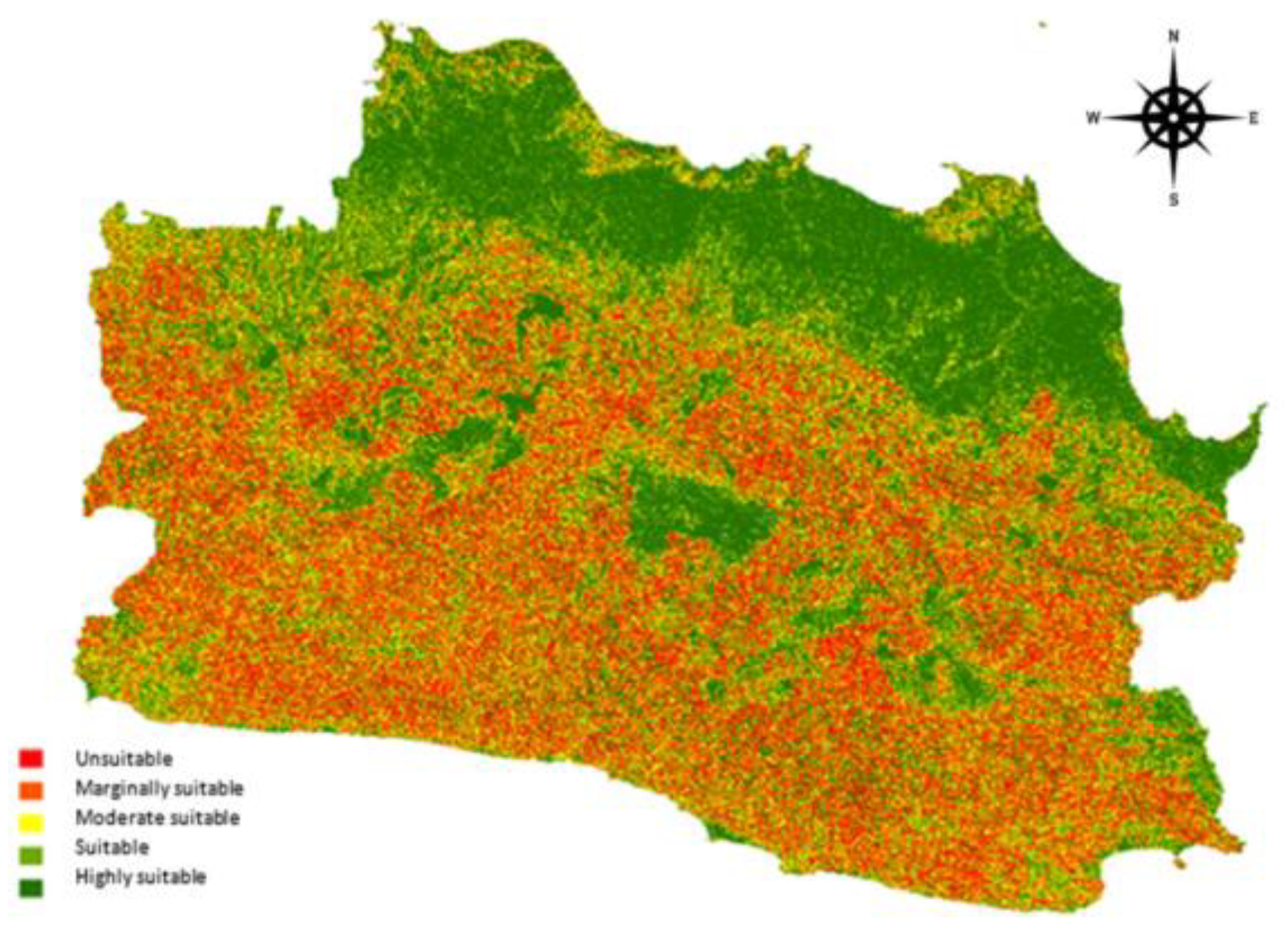
4.1.1. The Classification Based on the Soil Slope
The classification of land in West Java Province based on soil slope is depicted in
Figure 2 and detailed in
Table 3.
Based on the soil slope of West Java Province, 51% of the locations are suitable for industrial site use, whereas 49% are marginally suitable because they have a slope exceeding 15%. A lesser slope is a prerequisite for more efficient industrial sites.
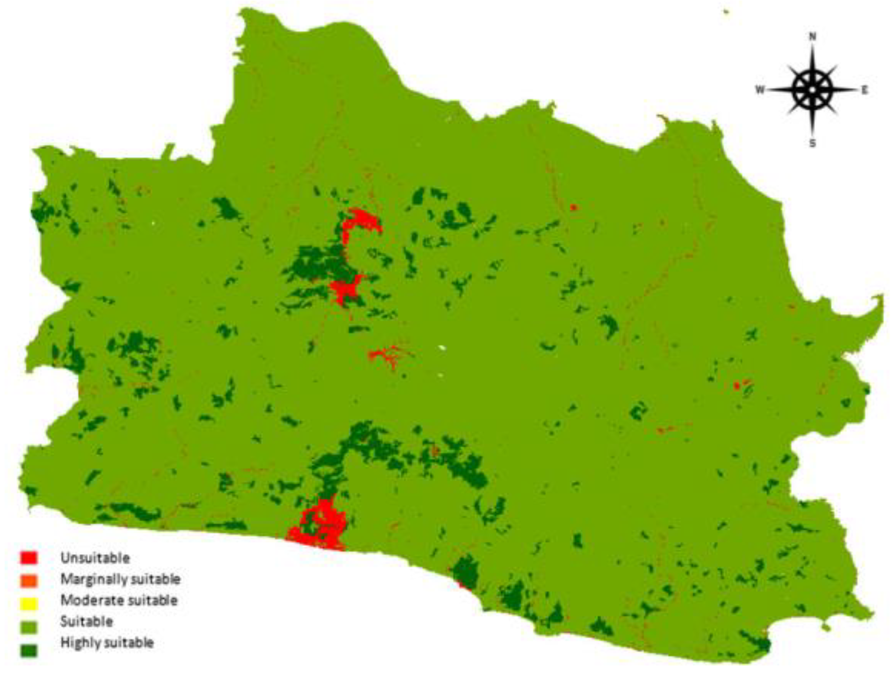
4.1.2. The Classification Based on the Land Use
The assessment results regarding land use are presented in
Table 4 and
Figure 3. Land use includes human activities on land, such as urban areas, settlements, and rice fields. Land use is classified based on prior research studies on land use/land cover classification [
51].
Based on the land use in West Java, the majority of locations (99%) are suitable for industrial site use, with only 1% being unsuitable as they are water bodies. Land use is a reference for policy making to prevent soil over-exploitation.
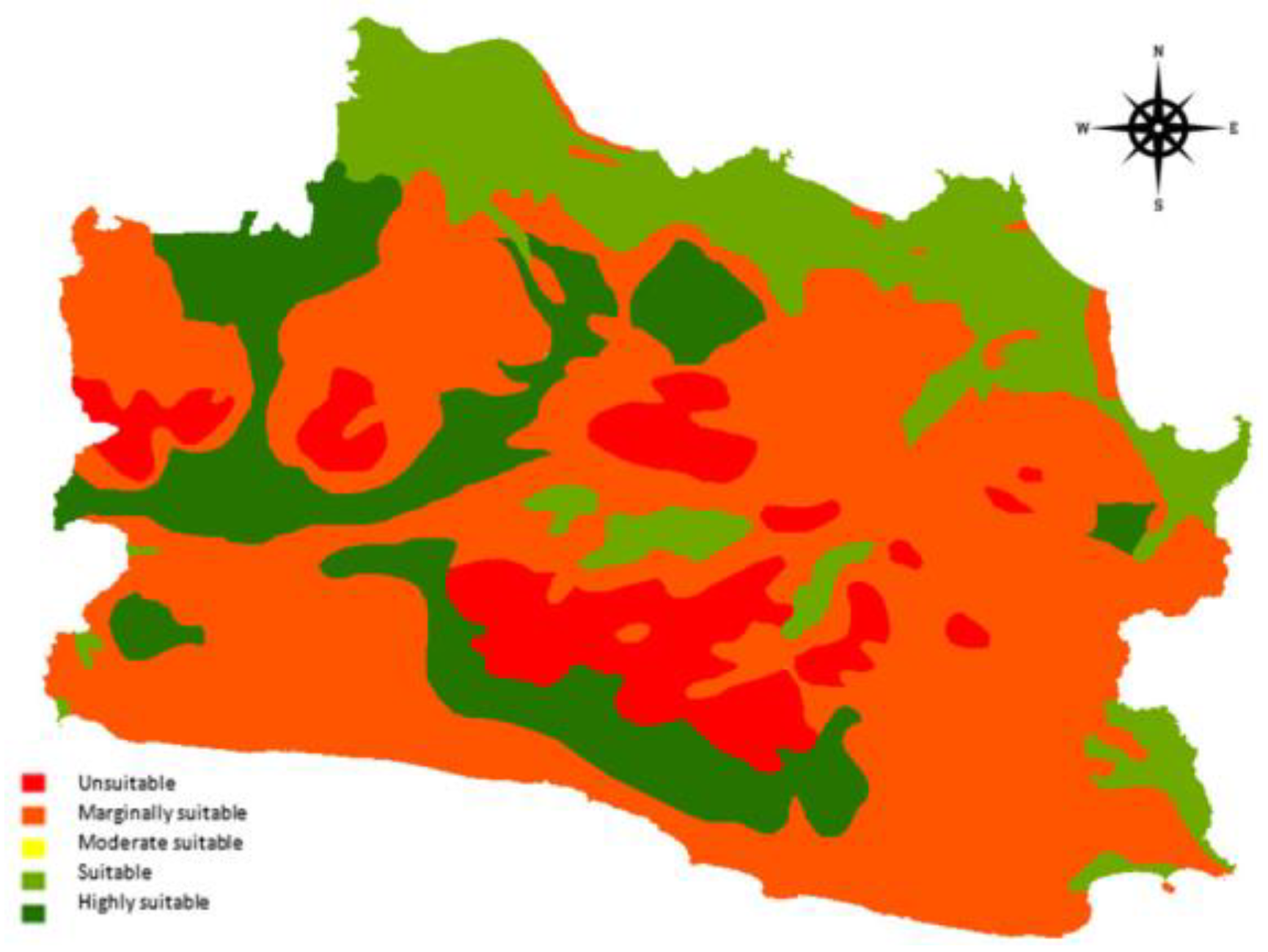
4.1.3. The Classification of the Soil Types
The assessment results based on soil types are presented in
Table 5 and
Figure 4.
The assessment indicates that 33% of the soil in West Java is suitable for industrial site locations, whereas the remaining 67% is unsuitable. This classification is based on fertility and land stability in the area.
4.1.4. The Classification Based on the Distance of Land to Road
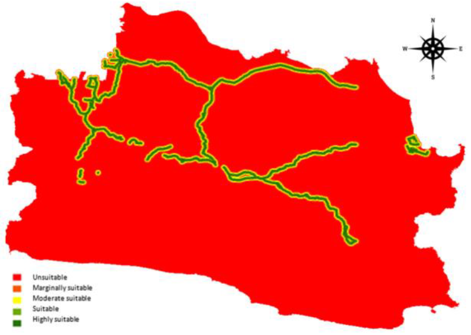
An assessment of the distance of land to roads and transportation access, which is a requirement for industrial sites, is presented in
Table 6 and
Figure 5. Proximity to roads is crucial for the convenient and efficient transportation of products, workers, and supplies.
The scoring for the distance of land to roads and access reveals that 6% of the locations are suitable for industrial sites, whereas 94% are less suitable or unsuitable. Consequently, new road constructions are required to enhance industrial site accessibility, which is vital for supporting the movement of people and products.
4.1.5. The Classification Based on the Distance of Land to Rivers
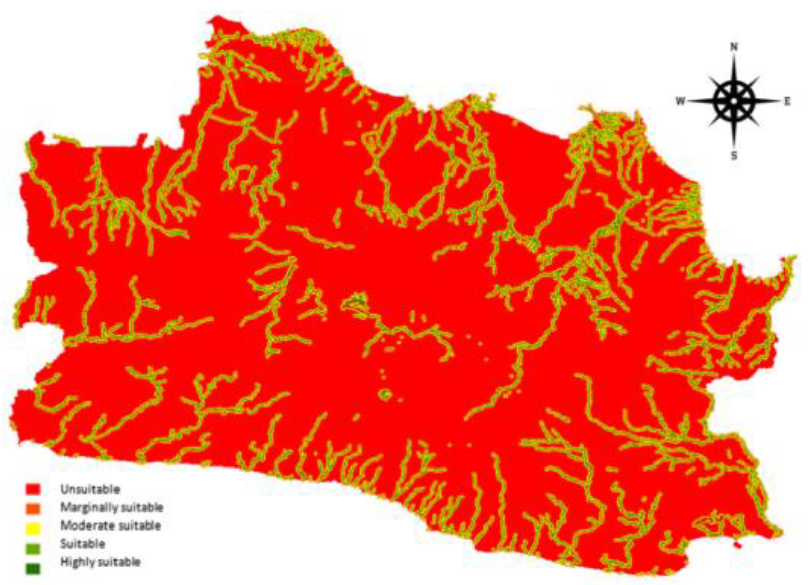
The assessment of the distance of land to rivers is presented in
Table 7 and
Figure 6. Proximity to rivers is important for accessing water resources used as industrial raw materials, as well as for managing industrial waste through water channels.
The scoring based on the distance of land to rivers shows that 15% of the sites are suitable for industrial use, whereas 85% are marginally suitable due to the greater distance from the river. The proximity to rivers is vital for handling processed industrial waste and serving as a water source for industrial activities.
4.1.6. The Classification Based on the Distance of Land to Public Facilities
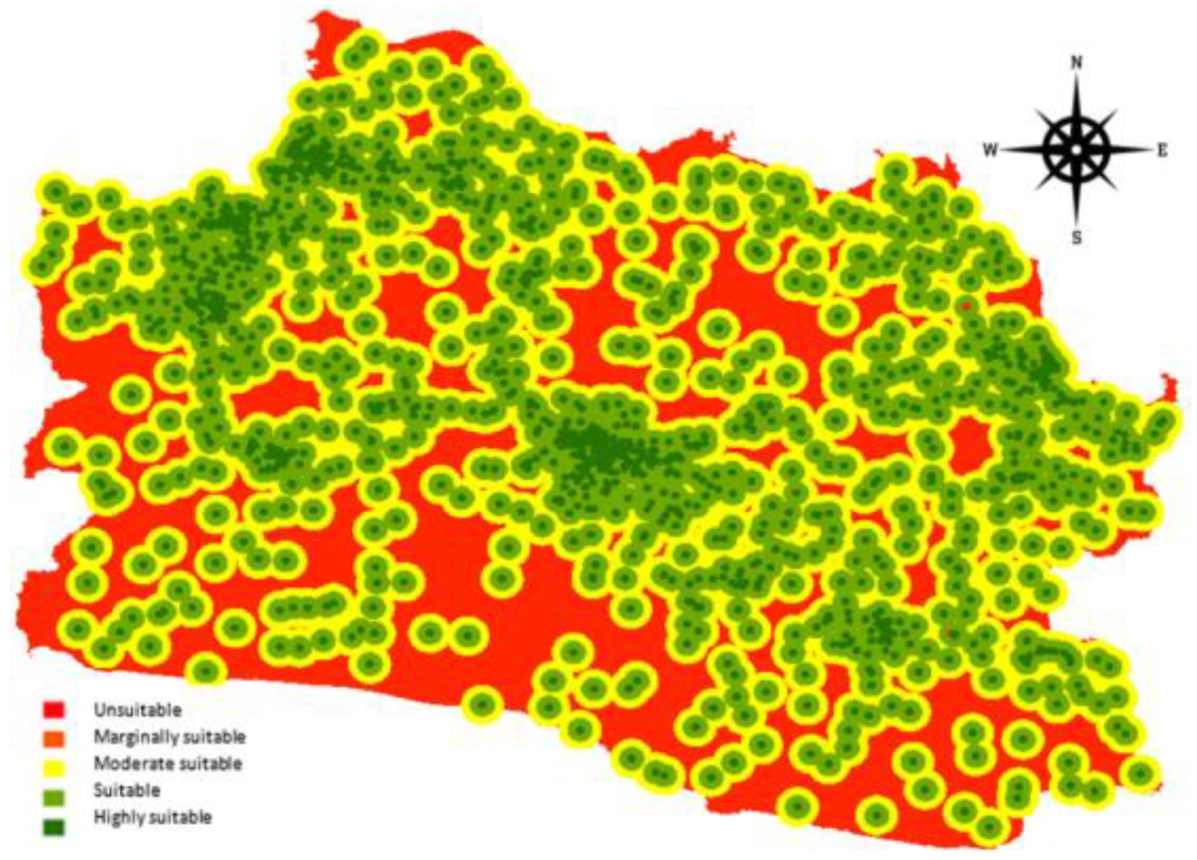
The assessment based on the distance of land to public facilities, specifically markets and terminals, is presented in
Table 8 and
Figure 7.
The scoring based on the distance of land to public facilities indicates that 47% of the sites are suitable for industrial use, whereas 53% are marginally suitable in terms of proximity to public facilities. Access to public facilities, such as markets, warehouses, settlements, health centers, trade centers, and ports, is crucial for product distribution, raw material flow, and workers’ mobility.
4.2. The Classification Based on the Total Score
By summing the scores for all six variables, the potential of industrial site land in West Java Province is classified into five categories, ranging from P1 (highly suitable) to P5 (unsuitable). The classification is presented in
Table 9.
The cumulative score of the six variables reveals that approximately 77% of the land area in West Java is suitable for industrial site development, whereas less than 23% is marginally suitable based on the criteria for industrial site selection.
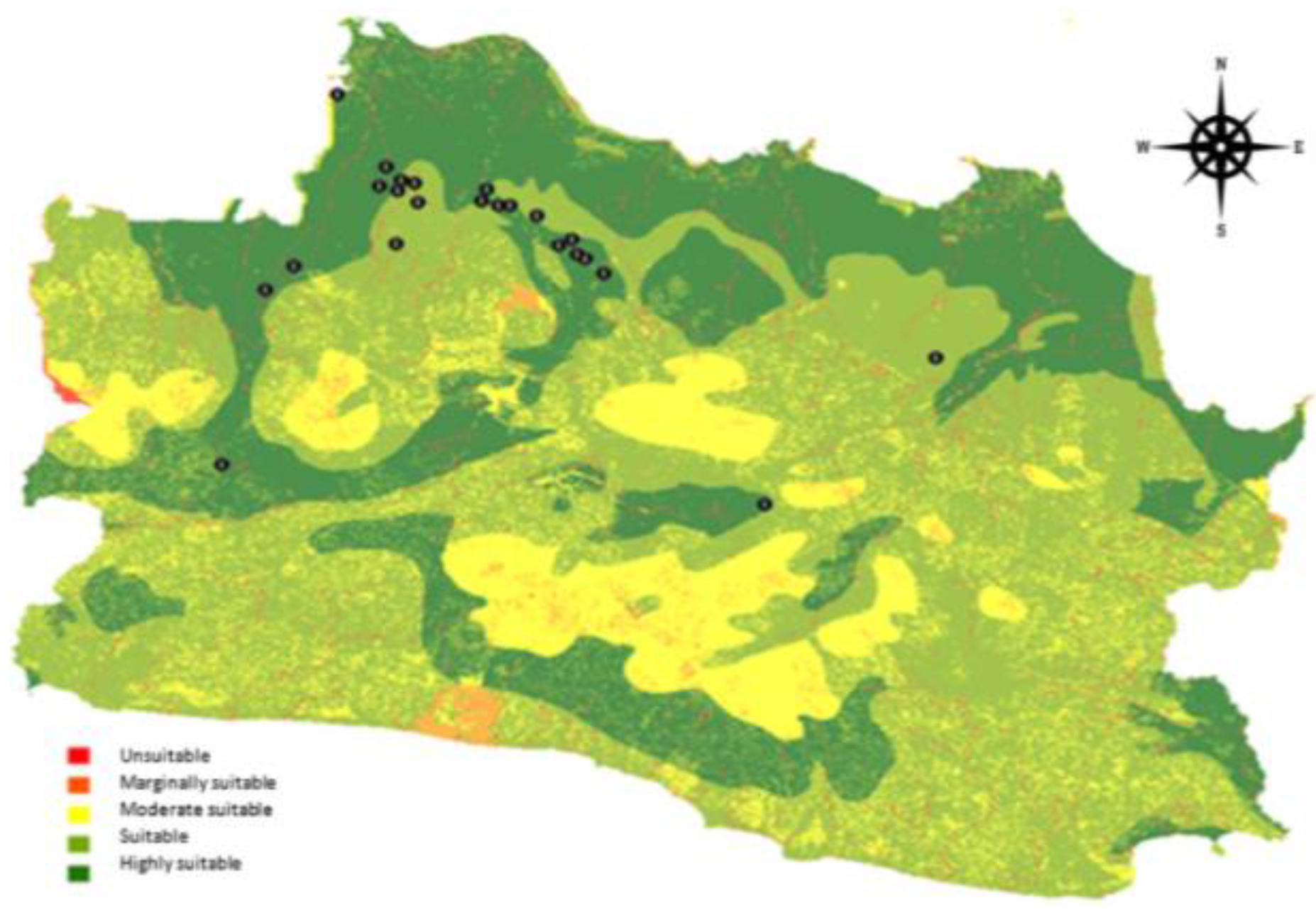
4.3. Evaluation of the Existing Map with Score
Additionally, based on the Industrial Site Spatial Plan (ISSP) of West Java Province for 2009–2029, industrial zone plans are represented as location symbols (points) rather than polygons (areas). There are 23 location points distributed in the plan for industrial site development.
Similarly, as depicted in
Figure 8, ’The Spatial Zoning Plan of West Java,’ the points on the map are organized as GIS data inputs for comparing the data related to the industrial site location plan in the Industrial Site Spatial Plan (ISSP) of West Java with the analysis data of industrial zone potentials obtained in the previous steps.
- -
Overlay map (ISSP industrial site spatial plan vs. analysis of industrial site potentials).
- -
Evaluation (industrial zoning plan vs. analysis of the assessment on industrial site)
The analysis results for the evaluation of the spatial zoning plan of West Java Province indicate that all 23 location points in the industrial zone plan align with the model for determining industrial sites via GIS analysis. Fourteen of these locations have been categorized as highly suitable, meeting the criteria for industrial zones according to the variables used in the study. The remaining nine locations are classified as suitable, as shown in
Table 10.
Figure 9, The Overlay Map, provides a visual representation of the overlay analysis.
The calculation reveals that 14 locations are highly suitable, and they fall under the jurisdiction of Karawang Regency (5 locations), Bekasi Regency (3 locations), Bogor Regency, and Purwakarta Regency (2 locations each), as well as Bandung Regency and Sukabumi Regency (1 location each). Additionally, nine locations are considered suitable, and they are situated in Bekasi Regency (5 locations), Karawang Regency (3 locations), and Majalengka Regency (1 location).
5. Discussion
The findings of this research make a significant contribution to the field of industrial location theory by incorporating the proximity factor, considering six research variables related to distance and land. What sets this model apart from previous studies is the innovative design of a web-based application, facilitating faster and more accessible industrial site assessments while taking into account risk and sustainability considerations. The practical implications of this model are extensive, as it can assist urban planners and government authorities in making well-informed decisions regarding industrial site planning, as well as reevaluating existing industrial site plans.
The strengths of this research are twofold. First, it employs highly detailed variables with specific criteria and scales based on prior research, enhancing the precision of its findings. Second, the research employs the Analytic Hierarchy Process (AHP) and a web-based Geographic Information System (GIS) to provide a comprehensive representation of spatial conditions. However, it is important to acknowledge certain limitations. The selected variables remain fundamental, thus limiting their capacity to resolve complex industrial site challenges, encompassing a broader spectrum of factors, including social, economic, and environmental aspects.
Subsequent research endeavors should incorporate additional critical variables, such as the availability of electricity and telecommunications networks, distances to ports and airports, land cost considerations, and wage data. Future research efforts should also explore the applicability of this model in different regions or countries, thereby bolstering the generalizability of the findings on a global scale. This model can serve as an invaluable tool for initial location assessments, although it necessitates further tailoring to accommodate unique site-specific conditions and critical considerations.
6. Conclusions
This study evaluated six key variables, including land slope, land use, land type, distance to road and accessibility, distance to rivers, and distance to public facilities. The assessment of these variables was conducted using the Analytic Hierarchy Process (AHP) and Geographic Information System (GIS) via a web-based application. This model not only serves for area assessments but can also be applied for the evaluation of government-established industrial site plans.
The analysis and mapping of West Java, Indonesia, revealed that 77% of the sites are suitable for industrial use, whereas 23% are only marginally suitable. The allocation of land designated for other purposes, such as settlements, offices, and public facilities, needs to be considered for these marginally suitable sites. The findings also indicate that both road accessibility (6%) and distance to rivers (15%) fall short of ideal conditions. Consequently, there is a need for infrastructure improvements, including road development and river widening.
The evaluation of the spatial zoning plan for industrial sites demonstrates that out of the 23 planned locations, 14 are highly suitable and 9 are classified as suitable. The highly suitable locations encompass five in the Regency of Karawang, three in the Regency of Bekasi, two in the Regency of Bogor, two in the Regency of Purwakarta, one in the Regency of Bandung, and one in Sukabumi. The suitable locations are distributed among the Regency of Bekasi (five locations), the Regency of Karawang (three locations), and the Regency of Majalengka (one location). It is advisable to conduct periodic evaluations of spatial zoning plans to account for evolving regional developments.
Furthermore, future research should explore the development of additional variables pertaining to production factors, such as land costs and wages, to enable the calculation of economic conditions at each industrial site location. Additionally, the environmental impacts of industrial sites should be integrated into the research model to mitigate potential negative effects. This model can be further refined and adapted as a decision-making tool for government policies related to industrial site planning. In subsequent research, the model’s applicability in different regions or countries should be assessed to enhance the global generalizability of the findings.
This research has some inherent limitations, including the reliability and validity of data sources and analytical techniques. Therefore, exploring alternative approaches for industrial site suitability analysis, such as fuzzy logic, machine learning, and other methodologies, is recommended.


 ,
, 
