Article

Ecological Risk Zoning Control in Zhundong Economic Development Zone Based on Landscape Pattern Changes

1
College of Geography and Remote Sensing Sciences, Xinjiang University, Urumqi 830046, China
2
Xinjiang Key Laboratory of Oasis Ecology, Xinjiang University, Urumqi 830046, China
3
College of Ecology and Environment, Xinjiang University, Urumqi 830046, China
*
Author to whom correspondence should be addressed.
Sustainability 2023, 15(22), 15972; https://doi.org/10.3390/su152215972
Submission received: 15 September 2023 / Revised: 3 November 2023 / Accepted: 13 November 2023 / Published: 15 November 2023
(This article belongs to the Special Issue Environmental Assessment and Management for Sustainable Development)

Abstract

:
The Zhundong coalfield in Xinjiang, China, is rich in resources and has great significance to the development of the Xinjiang region, but its local ecological environment is fragile and its climate is particularly dry, so mining is very likely to introduce a series of ecological risks; there is an urgent need for us to provide scientific and feasible guidance for the conservation and development of coal resources in this region. Therefore, this paper is based on the land-use-type data concerning the Zhundong Economic and Technological Development Zone from 2000 to 2020, exploring the land use change characteristics in the Zhundong area during these 20 years and calculating the ecological risk index of each risky district according to an ecological risk index model. Afterward, this article uses kriging interpolation to carry out a risk classification analysis to explore changes in ecological risk in the Zhundong area during the last 20 years and to put forward ecological risk partition and control measures for areas of different levels of risk. Our research shows the following features: (1) The land use type in the Zhundong area changed obviously from 2000 to 2020, in which unused land has always occupied most of the area of the Zhundong coalfield. Grassland was the land use type with the greatest area transferred, 211,412.35 hm2, accounting for 68.11% of the total transferred area, and it was mainly converted into unused and construction land. (2) In the last 20 years, the Zhundong coalfield has been dominated by higher-risk and high-risk areas, with obvious changes in the distribution of ecological risk levels. The low-risk, medium-risk, and higher-risk areas in the research zone have decreased and then increased; the lower-risk area has declined yearly, and the high-risk area has increased and then declined. Furthermore, overall, the ecological environment has transformed toward good condition. (3) High-risk and higher-risk areas still account for most of the research zone, and there is an urgent need for scientific and feasible programs to carry out ecological restoration in areas with different ecological risk levels to avoid further deterioration of the local environment.

1. Introduction

Coal resources account for about 70% of China’s energy composition [1,2]. With the rapid growth in China’s economy, the requirement for coal resources has escalated dramatically, and the conflict between domestic supply and demand has become increasingly prominent. Xinjiang is one of the provinces with the richest coal resources in the country [3], and it is an important resource reserve in China; in its identified mineral reserves, coal resources rank second in the country, with a reserve of 450.4 billion tons. This research focuses on the Zhundong coalfield. The Zhundong coalfield is the largest single coalfield in China; not only is it rich in coal resources, but it also has shallow buried coal seams and simple hydrogeology [4]. As a result, development and mining in the Zhundong coalfield are relatively easy, the mining potential is very high, and there is great strategic significance. However, the Zhundong coalfield is situated in the inland dry region of northwest China, with a fragile ecological environment, and most of the coal mines in this region are open-pit, the mining of which is very prone to cause irreversible ecological damage [5,6]. Therefore, how to develop the Zhundong coalfield carefully and scientifically is an urgent problem of great practical significance for the economic and social development in the Zhundong Economic Development Zone and surrounding areas. During the past few years, the number of investigations concerning the Zhundong coalfield (hereinafter referred to as the Zhundong area) has increased. He Jing et al. [7] conducted a study on the compensation of ecological development in the Zhundong area based on the ecosystem service value system. Wu Wei et al. [8] evaluated the comprehensive efficiency of different ecological restoration measures in the Zhundong area based on the data envelopment analysis (DEA) model. Hao-Chen Yu et al. [9] used image-by-image meta-trend analysis to show the spatial and temporal evolution of remote sensing ecological indices of drought in Zhundong, and further analyzed the impact mechanism of mining and climate change on land ecosystem quality in the Gobi mining district by using a multiple regression model and residual analysis. Fang Liu et al. [10] explored variations in the value of ecosystem services based on land use in the Zhundong coalfield. Yang Chuang et al. [11] proposed a green development direction for the Zhundong coalfield, and Zeng Qiang et al. [12] analyzed the distribution characteristics of coal resources and the ecological environment in the Xinjiang region. These scholars have studied various aspects of the Zhundong area.
Notwithstanding these studies, however, at this stage, research on the Zhundong coalfield is generally in the direction of coal mining technology; there is less research on the ecological risk in the Zhundong area, and there is still a lack of systematic research on the ecological restoration of the Northwest Inland Arid Zone. Additionally, existing ecological risk research in China tends to focus on coastal watersheds [13], urban administrative areas [14], ecologically fragile source areas [15], and other critical areas [16], and systematic and in-depth research on ecological risk in the Northwest Inland Arid Zone is lacking. During field visits and inspections carried out in recent years, this study found that the effect of ecological restoration in the study area at this stage is unsatisfactory, in addition to other problems; therefore, this study started with the change in land use types in the Zhundong area, conducted ecological risk research through a 20-year time series, and analyzed the causes of changes in areas with different risk levels. Lastly, the article suggests ecological restoration measures for areas with corresponding risk levels.
Ecological risk comprises the threat to ecosystems and their components, reflecting the adverse ecological effects of ecosystems as a result of anthropogenic activities and variations in the natural environment [17]. Landscape ecological risk assessment is an important branch of ecological risk assessment at the regional scale, that reflects the integration of geography and ecology, and pays more attention to the scale effect of ecological risk in a specific region [18,19], explaining and predicting the spatial and temporal distribution and characterization of ecosystem health and potential risk pressures [20]. During the last few years, with the acceleration in urbanization and industrialization, the influence of changes in land use structure on the ecological environment has become increasingly more significant [21,22,23], and the study of land use ecological risk has gradually become a leading theme and important issue in the domain of regional ecological risk research by scholars in China and abroad [24,25,26,27].
Land use changes can objectively reveal the degree of effect of land use categories on ecological comprehensiveness [28]. Thus, ecological risk analysis can be carried out through the structure of land categories and the characteristics of land use shifts. Regarding the larger scale of the Zhundong coalfield, ecological risk analysis of land use based on landscape structure can comprehensively assess various types of potential ecological effects and their cumulative consequences. Results can accurately show the spatial distribution of various ecological impacts and the characteristics of gradient changes. Therefore, ecological risk evaluation from the standpoint of land use transformation is one of the effective means to analyze the ecological restoration measures implemented in the Zhundong coalfield. However, new developments in the field of landscape ecological risk demand that the theoretical implications of the ecological effects of land use change need to be further detailed and defined [29], and evaluating how land use change represents ecological risk effects [30]. This is one of the research topics described in this report. In recent years, China has emphasized the protection of the ecological environment and promulgated a series of policy measures for pursuing the scientific and orderly promotion of mine ecological restoration. However, there is a lack of appropriate restoration tools for the ecological restoration of mining sites in inland drylands. Accordingly, based on available land use data, this paper calculated the ecological risk index for each region in the Zhundong coalfield for the period 2000 to 2020. Additionally, the article performed ecological-risk-level zoning to provide a theoretical basis for proposing corresponding region-specific ecological restoration measures that can be applied in the Zhundong coalfield.

2. Overview of the Research Zone and Methodology

2.1. Overview of the Research Zone

The Zhundong Coalfield is an important part of China’s 14th largest coal mining area and is situated in the eastern part of the Junggar Basin [31]. The Kalamere Mountains form the basin’s northern edge [32] and the Bogda Mountains border its southern edge. The terrain, as shown in Figure 1, is high in the northeast and low in the southwest [33], and slopes gently from the north, east, and south margins toward the center, with a general east-to-west tilt in its shallow disk-shaped basin. The elevation of the southern foothills of the Kalamere Mountains in the north is 700–1000 m, the elevation of the northern foothills of the Bogda Mountains in the south is 800–1500 m, and the elevation at the center of the basin ranges from 700 to 500 m east to the west, decreasing to the west at a slope of 0.5 m km−1; the terrain is generally relatively flat. The basin experiences a continental arid desert climate, with large variations in annual and diurnal temperatures [34] and an average annual rainfall of 106 mm, while the average annual evapotranspiration ranges from 1202 to 2380 mm. Hydrographically, the northern part of the Zhundong region is extremely undeveloped, with no annual flowing surface water; temporary runoff formed by summer rainfall is discharged southward into the desert, and some of it is collected and evaporated in low-lying areas. There are a few springs and wells within the basin, but the volume of water is very small and its quality extremely poor. Thus, it can be seen that the environment of origin in this area is fragile [35,36] and highly vulnerable to disturbance caused by external factors, while open-cast coal mines will inevitably exacerbate the destruction of the natural environment in the region.

2.2. Data Sources and Processing

For the analysis presented in this article, land use data were obtained from the Institute of Geographic Sciences and Resources of the Chinese Academy of Sciences (http://www.resdc.cn/, accessed on 23 March 2023) for China’s land use/land cover remote sensing monitoring data covering five periods: 2000, 2005, 2010, 2015, and 2020. These data were supplemented with those gathered for previous years through online searches, field surveys, and reports of coal mines in the Zhundong Economic Development Zone. Other socioeconomic-related data were obtained through the same sources. The DEM used in this article was acquired from the Geospatial Data Cloud Platform (https://www.gscloud.cn/, accessed on 25 March 2023).
Combining the actual situation of the Zhundong coalfield, local landscape characteristics, and the relevant literature relating to the Zhundong coalfield and other elements, this analysis selected six broad landscape types: cultivated land, meadow land, forest land, waters, construction land, and unused land according to the frontier of the research zone. ArcGIS 10.2 software was used to crop and reclassify land use data, and the software’s spatial analysis function was used to convert the data into a raster format. Afterward, this study applied the software’s Create Fishnet and Segmentation tools to the land-use-type data in the project area for grid segmentation, dividing the area into risky neighborhoods. This paper also used Fragstats 4.2 and Excel software 2007 tools to calculate the results of the processing, resulting in the ecological risk index of the risky neighborhoods. Next, this study imported the resulting ecological risk index into the ArcGIS 10.2 software package to carry out kriging interpolation analysis, which provided the ecological risk class classification for the research zone. Once the ecological risk classification was complete, the landscape pattern was analyzed and supplemented with field research data, statistical yearbook data, Zhundong coalfield report data, and other data, which ultimately provided support for the remediation of different levels of ecological risk in the research zone.

2.3. Research Methodology

Ecological Risk Modeling

To best construct the ecological risk model, this study queried a large number of related reports in the literature to select the most appropriate model cell size, which was found to be 2–5 times the average patch area [37]. The final choice for the Zhundong research zone was to create a grid consisting of 2000 m × 2000 m square cells, thus segmenting the region into a total of 4054 risk plots.
The ecological environment around an open-pit coal mine is fragile, and the study coalfield is situated in the inland dry zone of northwest China, where the landscape changes caused by human activities are obvious. Therefore, based on studying a large amount of the literature, and with reference to ecological risk evaluation studies and the features of the landscape pattern in the research zone, this study selected the following three factors to construct a calculation model for the index of landscape interference (Ui): index of landscape fragmentation (Ci), separation (Si), and dominance (Ki) [38,39]. Ran et al.’s [29] study based on this modeling framework is widely recognized. The formula is as follows:
U i = a C i + b S i + c K i
where the landscape fragmentation index Ci is:
C i = n i A i
and ni is the number of patches of landscape type i and Ai is the total area of landscape category i.
The landscape separation index Si is:
S i = A 2 A i n i A
where A is the total landscape area.
The degree of landscape dominance Ki is:
K i = 1 4 n i N + m i M + A i 2 A
By reviewing the corresponding literature and based on the actual conditions in the project area, variables a, b, and c in Equation (1) were assigned the values 0.5, 0.3, and 0.2 [40,41], respectively. The meaning of each parameter is the degree of influence that each index has on the value of landscape ecological services, and a + b + c = 1.
In addition, with the help of the landscape ecology method, the degree of landscape disturbance (Ui), the degree of vulnerability (Ei), and the index of loss (Ri) were selected as the risk evaluation indexes [19,42,43]:
R i = E i × U i
where degree of vulnerability (Ei) refers to the fragility of ecosystems caused by strong human disturbances. When the fragility is smaller, the risk to ecosystems is also smaller, vulnerability (Ei) was obtained through the examination of the previous literature [44]. Combined with the actual conditions in the Zhundong coalfield, the values for construction land, forest land, meadow land, cultivated land, waters, and unused land were assigned as 1–6, respectively, and normalized to derive the fragility index for each landscape category.
The landscape ecological risk index (ERI) was constructed based on each index [45]:
E R I i = i = 1 N A k i A k R i
where Aki denotes the area of landscape type i in the kth risk plot, Ak is the area of the kth risk plot, and Ri denotes the lossiness index of landscape type i.
Using ArcGIS 10.2 and Fragstats 4.2 software, the value for each risk plot during the period 2000 to 2020 was exported for the land use types, and the Excel software package was used to calculate each risk plot. The results of the calculations were then interpolated to the ERI of each risk plot using kriging interpolation in the ArcGIS software package, and the interpolation results were graded according to the natural breakpoint method [46]. Based on multiple references in the literature [39,47] and the actual conditions in the study area, five ecological risk class zones were delineated: lower-risk (0–0.071), low-risk (0.071–0.093), medium-risk (0.093–0.115), high-risk (0.115–0.145), and higher-risk (ERI > 0.145).

3. Results and Analysis

3.1. Analysis of Land Use Change

After reclassifying the land use data for each year in the Zhundong coalfield, as can be seen in Table 1, there are significant changes in the area of each land use type between 2000 and 2020. By 2020, the area of unused land was 1,424,536.02 hm2, accounting for 92.25% of the total area of the Zhundong coalfield. As the land is relatively barren and the land use categories are fairly narrow, the local ecological environment is fragile. Over the past 20 years, the areas of cultivated land, water, construction land, and unused land have all been increasing (Table 2), with construction land and unused land increasing significantly, by 23,874.44 and 109,997.56 hm2, respectively, while the areas of arable land and water have increased to a lesser extent, by only 22.54 and 578.7 hm2. In contrast, the area of forest land and meadow land decreased significantly, with forest land decreasing by 829.55 hm2 and meadow land decreasing by 133,643.7 hm2. After 2005, with further construction and development in the Zhundong coalfield, the area of unused land grew dramatically, and the area of meadow land and forest land decreased sharply, especially after 2010. The Zhundong coalfield has experienced continuous ecological degradation: the already fragile ecological environment of the local area has further deteriorated, with the ecological risk rising and many ecological issues occurring, which seriously restricts economic and social development in the local area. Thus, there is a great need for scientific and feasible conservation programs to achieve sustainable development in the Zhundong coalfield.
Using ArcGIS software package, the intersection analysis of five-phase images from 2000 to 2020 was carried out to obtain the land-type transfer matrix across 20 years, and the land-type transfer map of the coalfield was made according to the results (Figure 2). As can be seen in Table 2 and Figure 2 and Figure 3, meadowland is the land type with the largest transferred area, with a transfer out of 211,412.35 hm2, accounting for 68.11% of the total transfer-out area. The transferred area is dominated by unused land and construction land, with areas of 207,275.18 and 3763.69 hm2, accounting for 98.04% and 1.78% of the transferred area of meadow land, respectively, and the transferred areas for cultivated land, forest land, and water are 28.81, 30.18, and 314.49 hm2, respectively. Area conversions of varying sizes also occurred among other land types, but the magnitude of the increase or decrease was relatively small.

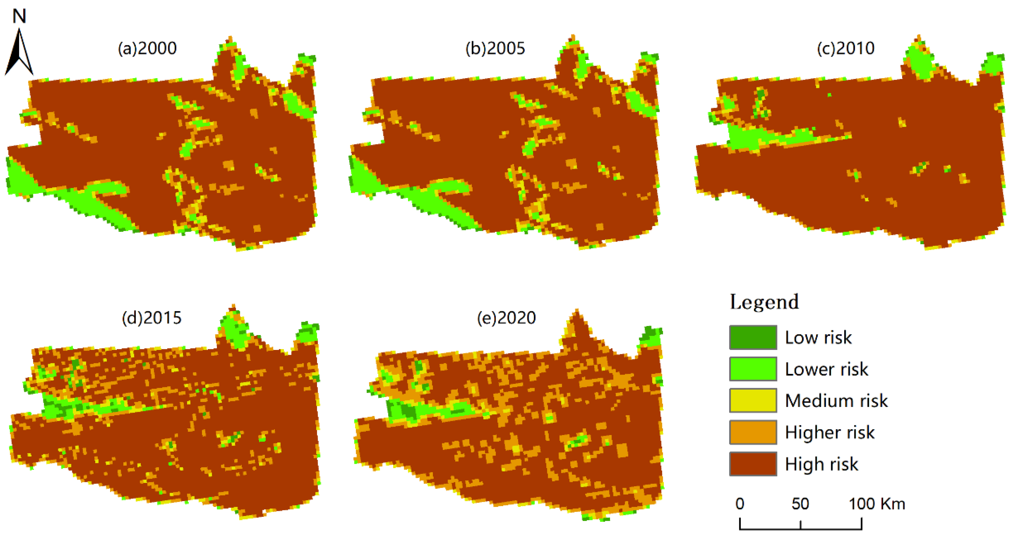
3.2. Calculation of the Ecological Risk Index for the Research Zone

Based on the ecological risk index model, the ERI for each ecological risk plot was calculated, and the calculated ERI was imported into ArcGIS software package for kriging interpolation analysis. Applying the natural breakpoint method to the analysis results for ecological risk grading, the study obtained a map showing the distribution of the ecological risk level for the Zhundong coalfield (Figure 4), and calculated (Table 3) based on the grading results. As shown in the figure and table, it can be seen that in the past 20 years, the Zhundong coalfield has been dominated by higher-risk areas and high-risk areas, and the distribution of its ecological risk levels has changed significantly. The area of low-risk, medium-risk, and higher-risk zones in the research zone decreased and then increased, the area of lower-risk zones decreased from year to year, and the area of higher-risk zones increased and then decreased. From the extended 20-year time series, the area of low-risk, medium-risk, and higher-risk zones increased by 17,974.59, 6790.40, and 218,091.74 hm2, respectively; the area of the lower-risk zone and the higher-risk zone decreased by 68,303.46 and 174,553.28 hm2, respectively.
As the Zhundong coalfield is situated in the easternmost part of the Junggar Basin in the Gobi Desert area, with inconvenient transportation, the Zhundong coalfield experienced a low degree of investigation in the last century, and has not been exploited on a large scale across a wide range [48], with an annual output of less than 30,000 tons of coal before 2005 and a very small amount of mining. Basically, the entire coalfield has yet to be exploited. From Figure 5, it can be seen that the regional ecological risk in the Zhundong coalfield basically remained unchanged between 2000 and 2005, and the ecological environment was less affected by human activities.
During the period 2005–2010, due to coal mine consolidation in 2007 and the expansion of mining in Zhundong coalfield, the ecological risk index increased in most parts of the coalfield region as a whole, and the area of high-risk zones grew dramatically, with serious damage to the ecological environment occurring. Nonetheless, the ecological risk index decreased and the ecological environment improved in some areas in the central and eastern parts of the coalfield.
Between 2010 and 2015, although a safety accident occurred in 2008 at the Laojunmiao mine in the Zhundong coalfield and all coal mines were forced to shut down, the ecological environment was not restored quickly due to a lag in ecological restoration [9]. Thus, after 2010, the overall regional ecological risk index of the Zhundong coalfield decreased as a whole. Although a series of developments were carried out in the coalfield after 2010, overall, the quality of the ecosystem improved in 2015 compared to 2010.
Between 2015 and 2020, the change in ecological risk level was relatively small, with the main change being that the area of the high-risk zone became smaller. This occurred because China has attached great importance to the ecological environment in recent years, enacted a string of policies and measures for the conservation of the ecological environment, and given increasingly more consideration to ecological environmental protection for the production activities of the mines. As a result, the deterioration of the fragile ecological environment has been significantly mitigated, and the ecological environment has become less vulnerable. A large number of lower-risk areas in the northeastern part of the region, however, have been transformed into higher-risk and high-risk areas, and the quality of the ecological environment has been degraded and reduced on a large scale.

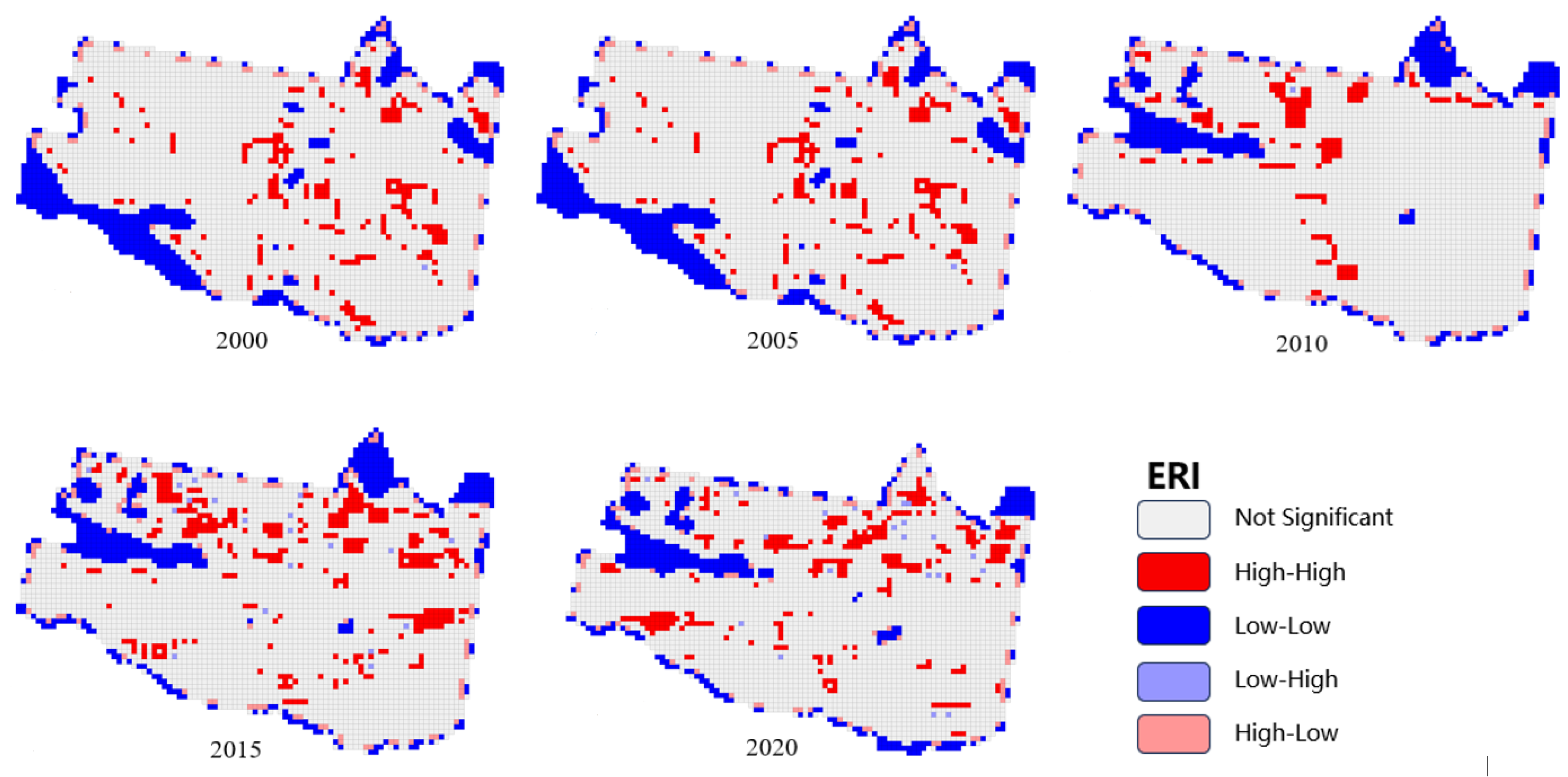
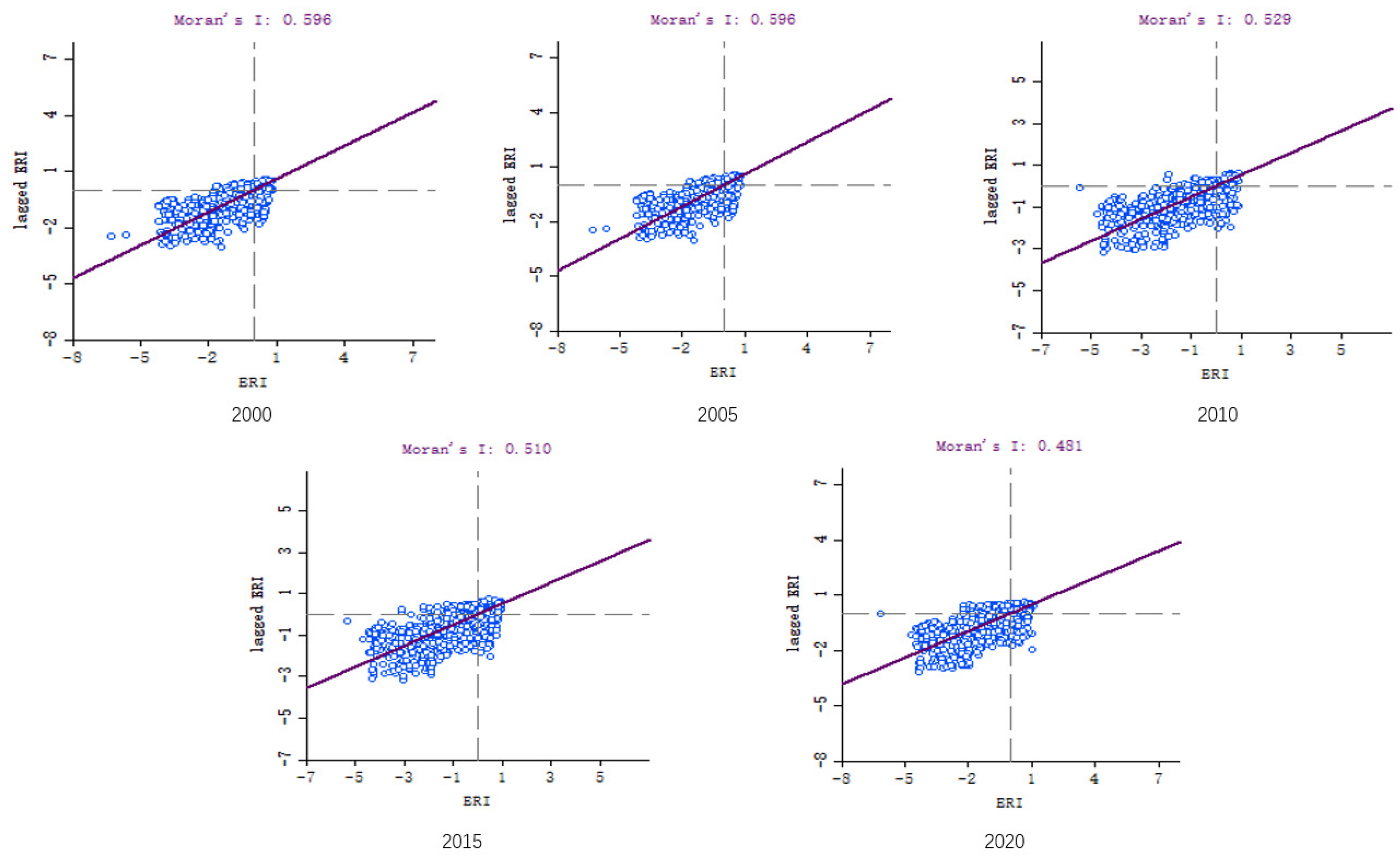
3.3. Spatial Autocorrelation Analysis of Landscape Ecological Risk

(1)
Ecological risk global autocorrelation analysis
The calculated ecological risk indices for each risk plot for the years 2000–2020 were imported into GeoDa software 1.8 to obtain Moran’s I scatter plots (global autocorrelation analysis). As shown in Figure 6, Moran’s I index is greater than 0 in each year and shows an increasing trend, indicating that the distribution of landscape ecological risk levels in the Zhundong coalfield during the period from 2000 to 2020 has a spatial positive correlation, and there is a clustering effect. Areas with high ecological risk values in the coalfield region have similarly high ecological risk values in neighboring areas, and districts with lower ecological risk values have lower ecological risk values in neighboring areas.
(2)
Local correlation analysis of ecological risks
Further local autocorrelation analysis of the ecological risk of the Zhundong coalfield was carried out using the GeoDa software package, and the LISA aggregation map of the research zone was obtained (Figure 7). In Figure 7, the spatial distribution of the ecological risk index at each year (2000, 2005, 2010, 2015, 2020) is primarily dominated by the high–high aggregation area and the low–low aggregation area, and both regions have a high degree of consistency with the spatial distribution pattern of ecological risk, with the low–low aggregation area more centralized in its distribution. From 2000 to 2005, ecological risk was primarily in the southwestern and northeastern regions; after 2005, the spatial distribution of ecological risks changed, and the low–low aggregation area changed to be mainly distributed in the west central and northeastern regions, which is related in recent years to the ecological restoration measures at the Wucaiwan and Jiangjunmiao mines in the west central region, such as the construction of reservoirs and ecological establishment of forests, among others. In addition, the high–high aggregation area is primarily located in the area where construction sites are concentrated and there are more human activities, causing greater anthropogenic interference in poorly stabilized ecosystems. Thus, the degree of loss in regional landscapes is also relatively higher.

4. Discussion

In recent years, China’s economic and social development has led to an increased demand for coal. The development and utilization of coal resources in the Zhundong coalfield is imminent, which is of great significance to the development of the Zhundong district [49]. Land use and ecosystems are closely related to the changes caused by coal mining and certainly cause changes in land types. Land use changes in mining areas are closely related to the policies implemented by China’s government [50], which continues to give attention to ecological environment, security, and protection. While there are fewer studies on ecological risk assessment in the inland arid zones of northwest China, after 2005, there has been large-scale development of coal resources in the Zhundong region and a lack of corresponding theoretical basis for ecological risk research in the same period, with earlier approaches such as the ecological risk assessment model [51] being unable to cope with the increasing compound risks in the mining area. During this same period, coal mining has caused high levels of damage to the ecological environment that have not been thoroughly researched. Although the local mining areas have responded positively to government policy and have vigorously promoted ecological restoration measures, there are remaining problems with the ecological restoration measures implemented in small areas. The effects of ecological restoration have been affected, so it is important to improve the efficiency of ecological risk assessment for the sustainable development of ecosystems in arid zones [52]. Therefore, the paper analyzed the ecological risk level in each region of the Zhundong coalfield by calculating the changes in the regional ecological risk index based on the changes in land type during the period of 2000–2020. This method has been adopted in many, study areas today and has proven to be advantageous in mining areas [43,53] as well as in areas that are ecologically [54], and although the limitations of the method in terms of assessment have been noted [55], it is still the most suitable method for ecologically fragile areas in need of ecological restoration theoretical guidance at this stage [29]. The recommended ecological restoration measures are as follows:
(1)
For low-risk and lower-risk zones, the study found that the transition to high-risk and high-risk zones should be controlled. The low-risk and lower-risk areas in the research zone are mainly the original local meadow land, forest land, and subsequent ecological restoration forest and grassland areas. Precipitation is relatively scarce in the research zone and must be supplemented by scientifically feasible methods to artificially restore tree plantations and grasses, such as a selection of local drought-, saline-, and cold-resistant adaptive plants in the planting of forests and grass to take advantage of the recent years of aridity in northwest China, the “green” trend [56], and the promotion of local ecosystems and sustainable socioeconomic development. However, improvements in ecosystem quality cannot be judged by the amount of vegetation planted alone. After fieldwork in some areas of the Zhundong coalfield during 2021 and 2022, this study found that the ecological restoration measures of vegetation planting in the mining area also brought about a range of problems, such as soil erosion and salinization. Therefore, the search for locally appropriate vegetation planting methods requires a certain amount of scientific practice and should not be considered as a temporary “greening”. As for the original forests and grasslands in the local area, local government departments should try to avoid these areas when planning for development and construction, and formulate good protection measures to minimize the ecological damage caused by human activity.
(2)
For the higher and high-risk areas, the study concluded that the existing favorable situation should be maintained. The higher and high-risk areas in the research zone mainly refer to the original ecological fragility of the area and the extent of human activity on the land, for which local government departments and corporations can introduce advanced mining technology and the corresponding mining protection measures, such as ecological restoration of the gangue landfill area of the mining district. These sectors and businesses can also minimize the damage to the area around the mining activity by optimizing the spatial layout of the mine. The mining area is in an extremely arid zone, where groundwater is the primary source of water for production and domestic use, and production and development should ensure water resource conservation and prevent the further expansion into high- and higher-risk zones areas, rather than focusing on the economic value brought by exploitation. For the original ecologically fragile areas, it is possible to reduce the construction of mining roads, control heavy metal pollution from mining and minimize damage to sites outside construction and production areas.
(3)
The medium-risk areas in the research zone are mainly low- and high-risk interface areas, which are ecological buffer zones. For the medium-risk zone, the transformation to high-risk zones should be reduced and such transformation and the transformation of low-risk zones to medium-risk zones can be prevented through relevant ecological protection measures, such as planting suitable vegetation and constructing grass-planting squares to stabilize sand with vegetation and prevent sand erosion, which would be helpful in curbing further expansion of high-risk zones and subsequent ecological degradation in the research zone.
There are several shortcomings in our analysis. For example, the land use category of construction land does not distinguish between residential and mining construction land, and therefore, the categories may not be sufficiently fine. In addition, for the selection of data, only five periods of data for a long time series (20 years) were chosen, and the analysis of some specific years was not sufficiently detailed, such as not analyzing the specific changes for each year in the study area during 2010–2015, but instead only researching and analyzing based on changes in two-year images and fieldwork data, which likely have some errors. Additionally, although land use change is closely related to the ecosystem, this study did not take into account the effect of local elevation, climate, and other natural sources of risk. As this study mainly refers to the impact of anthropogenic activity factors, it still lacks decisiveness. Our approach needs to be more refined in further research in order to seek a more in-depth and scientific analysis of changes in the spatial pattern of ecological risk in the Zhundong coalfield region, and to put forward specific and feasible ecological restoration and control measures for large-scale open-cast coal mines in arid zones.

5. Conclusions

This article analyzes the spatial changes in ecological risk in the Zhundong coalfield region from 2000 to 2020, providing a scientific theoretical basis for the conservation of the ecological environment in the research zone. In recent years, there have been few studies that evaluate ecological risk in arid areas, and there is a lack of corresponding theoretical foundations for the restoration of mines in the inland arid areas of northwest China. The present study, however, is a useful exploration of the ecological restoration measures that can be applied in the surface coal mines in northwest China, which is based on correlating ecological risk and land use.
The study investigated the landscape pattern changes and ecological risk-level changes in the Zhundong coalfield using five periods of land use data, arriving at the following conclusions:
(1)
Most of the research zone is unused land. Between 2000 and 2020, the area of cultivated land, water area, construction land, and unused land increased, while the area of meadow land and forest land decreased. In particular, meadow land was transformed into other types of land, which is closely related to the continuous development in the area during the last few years, such as an increase in population, increasing need for land, and expansion in the mining area.
(2)
The ecological risk pattern of the research zone is clearly distributed, with the high-risk and higher-risk areas consistently accounting for most of the total area of the research zone during the 20-year period, with the area of the higher-risk zones decreasing and then increasing, and the area of the high-risk zones continuing to decline. From the general viewpoint of the Zhundong coalfield, the ecological risk index has been reduced during the last 20 years, and the ecological environment quality is on an improving trend, but most of the areas remain ecologically fragile. Changes in risk level have a greater impact on the surrounding environment, and as shown from the field visits, the medium-risk areas around the mine face a series of problems such as water shortage and soil salinization. Scientific and feasible protection measures are needed to protect the ecological environment from further deterioration.
(3)
During the 20-year period, the spatial distribution of the overall ecological risk in the Zhundong coalfield has a positive correlation, with a high degree of aggregation, and the spatial pattern of landscape ecological risk is more consistent with the variations in the actual ecological risk index.

Author Contributions

Investigation, T.Y., J.J. and A.A. (Adila Akbar); supervision, A.Z. writing—original draft, B.O.; writing—review and editing, B.O. and A.A. (Abudukeyimu Abulizi). All authors have read and agreed to the published version of the manuscript.

Funding

This research was funded by the Key Project of Joint Funds of the National Natural Science Foundation of China, “The coal resources of protective exploitation and environmental effects in Xinjiang” (Grant No.U1903209) and the National Natural Science Foundation of China, “Assessment and source identification of heavy metal exposures of wild animals in Xinjiang Kalamaili Mountain Nature Reserve” (No. 42167058).

Institutional Review Board Statement

Not applicable.

Informed Consent Statement

Not applicable.

Data Availability Statement

The data used to support the findings of this study are available upon request.

Acknowledgments

We thank the Key Project of Joint Funds of the National Natural Science Foundation of China and the National Natural Science Foundation of China, “Assessment and source identification of heavy metal exposures of wild animals in Xinjiang Kalamaili Mountain Nature Reserve”, for their support of this research.

Conflicts of Interest

The authors declare no conflict of interest.

References

  1. Chen, F.; Yu, H.; Bian, Z.; Yin, D. How to handle the crisis of coal industry in China under the vision of carbon neutrality. J. China Coal Soc. 2021, 46, 1808–1820. [Google Scholar] [CrossRef]
  2. de Souza, M.R.; da Silva, F.R.; de Souza, C.T.; Niekraszewicz, L.; Dias, J.F.; Premoli, S.; Corrêa, D.S.; do Couto Soares, M.; Marroni, N.P.; Morgam-Martins, M.I.J.C. Evaluation of the genotoxic potential of soil contaminated with mineral coal tailings on snail Helix aspersa. Chemosphere 2015, 139, 512–517. [Google Scholar] [CrossRef]
  3. Li, J.; Zhuang, X.; Querol, X.; Font, O.; Moreno, N.; Zhou, J. Environmental geochemistry of the feed coals and their combustion by-products from two coal-fired power plants in Xinjiang Province, Northwest China. Fuel 2012, 95, 446–456. [Google Scholar] [CrossRef]
  4. Lv, Y.; Ma, Y. Cost estimation and standard determination for eco-compensation in Zhundong coalfield in Xinjiang. J. Arid Land Resour. Environ. 2014, 28, 39–43. [Google Scholar] [CrossRef]
  5. Yu, S.; Wang, F.; Yang, A. Remote Sensing Monitoring of Land Use Change in Pingshuo Open-pit Mine. Bull. Surv. Mapp. 2015, 4, 86–90. [Google Scholar] [CrossRef]
  6. Wu, H. Analysis of the Current Situation and Ecological Impact of Surface Coal Mining. Min. Equip. 2023, 72–74. Available online: https://www.zhangqiaokeyan.com/academic-journal-cn_mining-equipment_thesis/02012100740484.html (accessed on 25 March 2023).
  7. He, J.; Wang, Z.; Dong, W. Research on the Ecological System Service Value in Zhundong Mining Area. Environ. Prot. Xinjiang 2015, 37, 41–44. [Google Scholar] [CrossRef]
  8. Wu, W.; Wang, X.; Shi, Q.; Ma, Y.; Wang, Z.; Yuan, T.; Li, T. Comprehensive Efficiency Evaluation of Different Ecological Restoration Measures Based on DEA Model-Taking Xinjiang Zhundong Mining Area as an example. Min. Res. Dev. 2020, 40, 141–148. [Google Scholar] [CrossRef]
  9. Yu, H.; Chen, F.; Yin, D.; Han, X.; Mu, S.; Lei, S.; Bian, Z. Effects of mining activities and climate change on land ecosystem in Gobi mining area: A case study of Zhundong Coal Base. J. China Coal Soc. 2021, 46, 2650–2663. [Google Scholar] [CrossRef]
  10. Liu, F.; Yu, K.; Zhang, J.; Guo, W.; Yin, S. Temporal and Spatial Variations of Land Uses and Their Influences on Ecosystem Service Values around the Opencast Coal Mining Area of East Junggar Basin in Xinjiang. Ecol. Econ. 2021, 37, 169–175. [Google Scholar]
  11. Yang, C.; Li, C. Coal quality characteristics and green development and utilization direction of Zhundong coalfield in Xinjiang. Shaanxi Coal 2022, 41, 85–89. [Google Scholar]
  12. Zeng, Q.; Li, G.; Dong, J.; Pu, Y. Typical Ecological and Environmental Issues and Countermeasures in Coal Miningin Xinjiang Region. Min. Saf. Environ. Prot. 2017, 44, 106–110. [Google Scholar]
  13. Thoma, K.; Scharte, B.; Hiller, D.; Leismann, T. Resilience engineering as part of security research: Definitions, concepts and science approaches. Eur. J. Secur. Res. 2016, 1, 3–19. [Google Scholar] [CrossRef]
  14. Shi, H.; Yang, Z.; Han, F.; Shi, T.; Li, D. Assessing Landscape Ecological Risk for a World Natural Heritage Site: A Case Study of Bayanbulak in China. Pol. J. Environ. Stud. 2015, 24, 269–283. [Google Scholar] [CrossRef] [PubMed]
  15. Dong, D.; Sun, W.; Zhu, Z.; Xi, S.; Lin, G. Groundwater risk assessment of the third aquifer in Tianjin city, China. Water Resour. Manag. 2013, 27, 3179–3190. [Google Scholar] [CrossRef]
  16. Lan, Y.; Chen, J.; Yang, Y.; Ling, M.; You, H.; Han, X. Landscape Pattern and Ecological Risk Assessment in Guilin Based on Land Use Change. Int. J. Environ. Res. Public Health 2023, 20, 2045. [Google Scholar] [CrossRef]
  17. Zhang, X.; Wang, R.; Li, Z.; Li, F.; Wu, J.; Huang, J.; Yu, Y. Comprehensive assessment of urban ecological risks:the case of Huaibei City. Acta Ecol. Sin. 2011, 31, 6204–6214. [Google Scholar]
  18. Leuven, R.S.E.W.; Poudevigne, I. Riverine landscape dynamics and ecological risk assessment. J. Freshw. Biol. 2002, 47, 845–865. [Google Scholar] [CrossRef]
  19. Cao, Q.; Zhang, X.; Lei, D.; Guo, L.; Sun, X.; Kong, F.; Wu, J. Multi-scenario simulation of landscape ecological risk probability to facilitate different decision-making preferences. J. Clean. Prod. 2019, 227, 325–335. [Google Scholar] [CrossRef]
  20. Kang, Z.; Zhang, Z.; Wei, H.; Liu, L.; Ning, S.; Zhao, G.; Wang, T.; Tian, H. Landscape ecological risk assessment in Manas River Basin based on land use change. Acta Ecol. Sin. 2020, 40, 6472–6485. [Google Scholar]
  21. Cao, Y.; Bai, Z. Analysis of change and driving force of land utilization in AN Taibao open-cast mine. Resour. Ind. 2006, 4, 102–106. [Google Scholar] [CrossRef]
  22. Wang, Q.; Guo, E.; Bu, R. Ecological Risk Evaluation of the Eastern Ordos Plateau Based on Land Use Changes—The Case of Jungar Banner. J. Chifeng Univ. (Nat. Sci. Ed.) 2020, 36, 26–30. [Google Scholar] [CrossRef]
  23. Wang, H.; Feng, R.; Li, X.; Yang, Y.; Pan, Y. Land Use Change and Its Impact on Ecological Risk in the Huaihe River Eco-Economic Belt. Land 2023, 12, 1247. [Google Scholar] [CrossRef]
  24. McIntyre, S.; Lavorel, S. A conceptual model of land use effects on the structure and function of herbaceous vegetation. Agric. Ecosyst. Environ. 2006, 119, 11–21. [Google Scholar] [CrossRef]
  25. Xiao, Y.; Mao, X. Spatial analysis of regional landscape ecological risk. China Environ. Sci. 2006, 26, 623–626. [Google Scholar]
  26. Liang, T.; Yang, F.; Huang, D.; Luo, Y.; Wu, Y.; Wen, C. Land-use transformation and landscape ecological risk assessment in the Three Gorges Reservoir region based on the “production–living–ecological space” Perspective. Land 2022, 11, 1234. [Google Scholar] [CrossRef]
  27. Najmuddin, O.; Li, Z.; Khan, R.; Zhuang, W. Valuation of Land-Use/Land-Cover-Based Ecosystem Services in Afghanistan—An Assessment of the Past and Future. Land 2022, 11, 1906. [Google Scholar] [CrossRef]
  28. Yanfen, Y.C.F. Ecological risk assessment for Pearl River Delta based on land use change. Trans. Chin. Soc. Agric. Eng. 2013, 19, 224–232. [Google Scholar] [CrossRef]
  29. Ran, P.; Hu, S.; Frazier, A.; Qu, S.; Yu, D.; Tong, L. Exploring changes in landscape ecological risk in the Yangtze River Economic Belt from a spatiotemporal perspective. Ecol. Indic. 2022, 137, 108744. [Google Scholar] [CrossRef]
  30. Wang, K.; Zheng, H.; Zhao, X.; Sang, Z.; Yan, W.; Cai, Z.; Xu, Y.; Zhang, F. Landscape ecological risk assessment of the Hailar River basin based on ecosystem services in China. Ecol. Indic. 2023, 147, 109795. [Google Scholar] [CrossRef]
  31. Zhu, C.; Zhang, Z.; Wang, H.; Wang, J.; Yang, S. Assessing Soil Organic Matter Content in a Coal Mining Area through Spectral Variables of Different Numbers of Dimensions. Sensors 2020, 20, 1795. [Google Scholar] [CrossRef] [PubMed]
  32. Jiang, J.; Abulizi, A.; Abliz, A.; Zayiti, A.; Akbar, A.; Ou, B. Construction of landscape ecological security pattern in the Zhundong region, Xinjiang, NW China. Int. J. Environ. Res. Public Health 2022, 19, 6301. [Google Scholar] [CrossRef] [PubMed]
  33. Xu, H.; Madina, M.; Yu, S.; Wang, Z.; Cheng, H.; Jiang, T. Geological Characteristics of Shale Reservoir of Pingdiquan Formation in Huoshaoshan Area, Junggar Basin. Processes 2023, 11, 2126. [Google Scholar] [CrossRef]
  34. Fan, T.; Pan, J.; Wang, X.; Wang, S.; Lu, A. Ecological Risk Assessment and Source Apportionment of Heavy Metals in the Soil of an Opencast Mine in Xinjiang. Int. J. Environ. Res. Public Health 2022, 19, 15522. [Google Scholar] [CrossRef]
  35. Lei, K.; Pan, H.; Lin, C. A landscape approach towards ecological restoration and sustainable development of mining areas. Ecol. Eng. 2016, 90, 320–325. [Google Scholar] [CrossRef]
  36. Li, S.; Xiao, W.; Zhao, Y.; Lv, X. Incorporating ecological risk index in the multi-process MCRE model to optimize the ecological security pattern in a semi-arid area with intensive coal mining: A case study in northern China. J. Clean. Prod. 2020, 247, 119143. [Google Scholar] [CrossRef]
  37. Xie, X.; Chen, Z.C.; Wang, F.; Bai, M.W.; Xu, W.Y. Ecological risk assessment of Taihu Lake basin based on landscape pattern. Chin. J. Appl. Ecol. 2017, 28, 3369–3377. [Google Scholar]
  38. Chen, P.; Pan, X. Ecological risk analysis of regional landscape in inland river watershed of arid area-acase stuay or Sangong River Basin in Fukang. Chin. J. Ecol. 2003, 22, 116–120. [Google Scholar]
  39. Lv, L.; Zhang, J.; Sun, Z.; Wang, X.; Zheng, D. Landscapeecological risk assessment of Xi river Basin based on land-use change. Acta Ecol. Sin. 2018, 38, 5952–5960. [Google Scholar] [CrossRef]
  40. Jiansheng, W.; Na, Q.; Jian, P.; Xiulan, H.; Jianzheng, L.; Yajing, P. Spatial variation of landscape eco-risk in open mine area. Acta Ecol. Sin. 2013, 33, 3816–3824. [Google Scholar] [CrossRef]
  41. Gong, J.; Zhao, C.; Xie, Y.; Gao, Y. Ecological risk assessment and its management of Bailongjiang watershed, southern Gansu based on landscape pattern. Chin. J. Appl. Ecol. 2014, 25, 2041–2048. [Google Scholar] [CrossRef]
  42. Li, Z.; Zhang, N.; Tang, J.; Ji, Y.; Liu, J. Analysis on the Landscape Ecological Risk of Jilin Coal Mining Area. J. Jilin Univ. (Earth Sci. Ed.) 2011, 41, 207–214. [Google Scholar] [CrossRef]
  43. Gong, J.; Cao, E.; Xie, Y.; Xu, C.; Li, H.; Yan, L. Integrating ecosystem services and landscape ecological risk into adaptive management: Insights from a western mountain-basin area, China. J. Environ. Manag. 2021, 281, 111817. [Google Scholar] [CrossRef] [PubMed]
  44. Zhang, Y.; Fang, Y.; He, F.; Shao, Q. Ecological Risk Dynamic Assessment Based on Simulation of Land Use Change. Geomat. Spat. Inf. Technol. 2016, 39, 5–8+12. [Google Scholar]
  45. Xu, Y.; Gao, J.; Gao, Y. Landscape ecological risk assessment in the Taihu region based on land use change. J. Lake Sci. 2011, 23, 642–648. [Google Scholar]
  46. Li, H.; Zhou, Q.; Li, B.; Guo, H.; Wang, F.; He, C. Spatiotemporal Change and Correlation Analysis of Ecosystem Service Values and Ecological Risk in Three Gorges Reservoir Area in the Past 30 Years. Resour. Environ. Yangtze Basin 2021, 30, 654–666. [Google Scholar]
  47. Wu, L.; Hong, X.; Di, X. Assessment of regional ecological risk in coastal zone of Shandong Province. Chin. J. Ecol. 2014, 33, 214–220. [Google Scholar] [CrossRef]
  48. Shen, L.; Zeng, Q. Multiscenario simulation of land use and land cover in the Zhundong mining area, Xinjiang, China. Ecol. Indic. 2022, 145, 109608. [Google Scholar] [CrossRef]
  49. Yin, D.; Li, X.; Li, G.; Zhang, J.; Yu, H. Spatio-Temporal Evolution of Land Use Transition and Its Eco-Environmental Effects: A Case Study of the Yellow River Basin, China. Land 2020, 9, 514. [Google Scholar] [CrossRef]
  50. Weber, N.; Haase, D.; Franck, U. Assessing modelled outdoor traffic-induced noise and air pollution around urban structures using the concept of landscape metrics. Landsc. Urban Plan. 2014, 125, 105–116. [Google Scholar] [CrossRef]
  51. Forbes, V.E.; Galic, N. Next-generation ecological risk assessment: Predicting risk from molecular initiation to ecosystem service delivery. Environ. Int. 2016, 91, 215–219. [Google Scholar] [CrossRef] [PubMed]
  52. Yao, L.; Zhang, X.; Luo, J.; Li, X. Identification of Ecological Management Zoning on Arid Region from the Perspective of Risk Assessment. Sustainability 2023, 15, 9046. [Google Scholar] [CrossRef]
  53. Jin, X.; Jin, Y.; Mao, X. Ecological risk assessment of cities on the Tibetan Plateau based on land use/land cover changes–Case study of Delingha City. Ecol. Indic. 2019, 101, 185–191. [Google Scholar] [CrossRef]
  54. Peng, J.; Dang, W.; Liu, Y.; Zong, M.; Hu, X. Review on landscape ecological risk assessment. Acta Geogr. Sin. 2015, 70, 664–677. [Google Scholar]
  55. Wang, H.; Liu, X.; Zhao, C.; Chang, Y.; Liu, Y.; Zang, F. Spatial-temporal pattern analysis of landscape ecological risk assessment based on land use/land cover change in Baishuijiang National nature reserve in Gansu Province, China. Ecol. Indic. 2021, 124, 107454. [Google Scholar] [CrossRef]
  56. Chen, C.; Park, T.; Wang, X.; Piao, S.; Xu, B.; Chaturvedi, R.K.; Richard, F.; Victor, B.; Philippe, C.; Rasmus, F.; et al. China and India lead in greening of the world through land-use management. Nat. Sustain. 2019, 2, 122–129. [Google Scholar] [CrossRef]
Figure 1. Map showing the Xingjiang prefecture and topography of the Zhundong coalfield.
Sustainability 15 15972 g001
Figure 2. Distribution of land-type transfer in the Zhundong coalfield, 2000–2020.
Sustainability 15 15972 g002
Figure 3. Land use classification of the Zhundong coalfield, 2000–2020 (ae).
Sustainability 15 15972 g003
Figure 4. Transfer matrix of ecological risk levels in the Zhundong coalfield, 2000–2020.
Sustainability 15 15972 g004
Figure 5. Distribution of ecological risk levels in the Zhundong coalfield between 2000 and 2020 (a)–(e).
Sustainability 15 15972 g005
Figure 6. Scatter plots showing ecological-risk Moran indices for the Zhundong coalfield during the period 2000 to 2020.
Sustainability 15 15972 g006
Figure 7. Distribution of local indicators of spatial autocorrelation (LISA) of ecological risks in the Zhundong coalfield during 2000–2020.
Sustainability 15 15972 g007
Table 1. Variation in the area of each land category in the Zhundong coalfield, 2000–2020 (hm2).
YearCultivatedForestMeadowWatersConstruction LandUnused Land
Area (hm2)Area (hm2)Area (hm2)Area (hm2)Area (hm2)Area (hm2)
200044.6892.01230,627.160539.051,314,511.61
200558.1894.41230,630.720538.821,314,491.83
201055.8961.74118,498.23012,956.851,415,046.6
201567.3261.74116,465.76524.3419,813.321,409,686.83
202067.2362.4696,959.34578.724,413.491,424,536.02
Table 2. Land-type transfer matrix for the Zhundong coalfield, 2000–2020 hm2.
CultivatedForestMeadowWatersConstruction LandUnused LandTotal Transfers
Cultivated- -000010.1410.14
Forest3.86- -594.8300261.03859.72
Meadow28.8130.18- -314.493763.69207,275.18211,412.35
Waters000- -000
Construction land0000- -273.44273.44
Unused land0077,173.83264.2120,384.19- -97,822.22
Total transferred32.6830.1877,768.65578.724,147.88207,819.79- -
Total net transfers22.54−829.55−133,643.7578.723,874.44109,997.56- -
Table 3. Changes in the size of areas with different ecological risk levels (hm2).
YearLow RiskLower RiskMedium RiskHigher RiskHigh Risk
200015,577.98129,816.5161,113.62132,213.131,207,892.73
200515,182.47129,450.5161,129.41136,642.211,204,209.38
201013,580.8086,278.0540,742.4176,691.601,329,321.10
201530,756.5372,697.2567,105.15205,309.811,170,745.23
202033,552.5861,513.0667,904.02350,304.871,033,339.45
Disclaimer/Publisher’s Note: The statements, opinions and data contained in all publications are solely those of the individual author(s) and contributor(s) and not of MDPI and/or the editor(s). MDPI and/or the editor(s) disclaim responsibility for any injury to people or property resulting from any ideas, methods, instructions or products referred to in the content.

