Abstract
Flash floods are a significant threat to arid and semi-arid regions, causing considerable loss of life and damage, including roads, bridges, check dams and dikes, reservoir filling, and mudslides in populated areas as well as agricultural fields. Flood risk is a complex process linked to numerous morphological, pedological, geological, anthropic, and climatic factors. In arid environments such as where Bayech basin is located in southwestern Tunisia, the hydrometric data are insufficient due to the absence of measuring points. Using the hybrid fuzzy Analytical Hierarchy Process (F-AHP) and the frequency ratio statistical methods, this study aims to map flooding risks in an ungauged basin that is extremely prone to flooding. Data related to soil texture, slope, land use, altitude, rainfall, drainage density, and distance from the river were used in the risk analysis. The obtained flood risk maps from both F-AHP and FR models were validated on the basis of the Receiver Operating Characteristic (ROC), the Area Under the Curve (AUC), and the inventory map. Results revealed that areas of high and very high susceptibility to flooding are mainly located in the downstream part of the basin, where the town of Gafsa is located. Other upstream sites are also at risk. In this basin, slope is predominantly behind runoff accumulation, whereas soil type plays a major role in amplifying waterproofing and therefore overflow. The results derived from both methods clearly demonstrate a viable and efficient assessment in flood-prone areas. The F-AHP and FR methods have ROC values of 95% and 97%, respectively. Considering these results in the decision-making process, these outputs would enable the implementation of the necessary measures to mitigate flood risk impacts ensure sustainable development along with an effective management in Tunisian arid environments, for the well-being of local communities at risk.
1. Introduction
The burning of fossil fuels causes climate change and severe hydrometeorological hazards [1,2]. Among various hydrometeorological hazards, floods are considered to be the most destructive in the world. Floods often cause serious loss of life and socio-economic damage [3]. Around 200 million people worldwide are estimated to be affected by floods every year [4].
In addition, due to climate change predictions, changes in land use patterns, and population growth, flood occurrence rates and intensity are expected to increase by 2050, which could result in considerable losses [5,6,7,8,9]. Regional flood risk maps are therefore essential to mitigate flood risk or to take sustainable adaptation and mitigation measures against the devastating effects of floods [10,11].
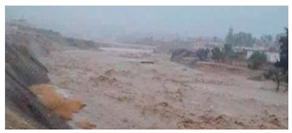
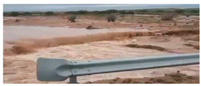
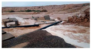
In Tunisia, over the past decades, many disastrous floods have occurred in the region, adversely affecting human lives, properties, agriculture, and other infrastructure [12]. The most damaging floods occurred in 1973–1974, 1989–1990, 1999–2000, 2009–2010, and 2019–2020. Fehri [13,14] reports that climate change has intensified the spatiotemporal variability of rainfall, posing a serious threat to local communities in the form of flooding. On the 22nd and 23rd of September 2009, the Gafsa region experienced an exceptional rainfall event as a result of very active atmospheric disturbances that approached Tunisia from the southwest. The event, with a total rainfall of 150 mm, caused a serious loss of life. Nearly 28 people were killed and many injured, and more than a third of the houses in the town of Redeyef were damaged; 750 head of livestock and around 45 vehicles were swept away [14]. As for the 17 October 2018 event, it claimed six lives in several Tunisian governorates. The event also caused extensive material damage. A number of educational establishments were damaged, and lessons were officially suspended in all schools. In Majel Bel Abbes, several homes were flooded and the electricity supply was cut off [15].
Flood risk depends on many environmental factors namely land use, soil texture, prevailing climate, geomorphology and hydrological parameters, etc. [16]. These factors need to be considered together when monitoring flood risk. In fact, changes in land use, urbanization and alteration due to fire, and inappropriate practices increase the surface impermeability and, consequently, the risk of run-off. Similarly, the dynamics of the socio-economic system, particularly in flood-prone areas, can contribute significantly to the increase in flood damage [17]. In the climate change, the frequency of exceptional rainfall events has increased and shown a spatiotemporal irregularity in intensity and distribution, leading to heavy socioeconomic losses, especially in arid environments.
Despite water and soil conservation techniques, many catchment areas are still affected by flooding. It is therefore important to develop approaches, methods, and tools for risk prediction incorporating the dominant factors influencing flood frequency. The former relies on expert knowledge to allow relative risk statements, while the latter provides quantitative results and susceptibility maps based on computational data and/or models.
Significant progress has been made in developing multi-criteria susceptibility mapping and hazard areas, much of which is based on the extensive use of Geographic Information Systems (GIS), survey data, and remote sensing techniques [18,19]. Hybrid methods are used to solve many types of problems. Among these methods, the fuzzy Analytic Hierarchy Process (F-AHP) is widely used to solve problems related to flooding [11].
This method uses approximate information and qualitative linguistic language (human opinion) to make decisions in complex problems. In addition, the F-AHP approach evaluates the relative importance of each criterion and provides an overall ranking of alternatives or factor weights. In the traditional AHP method, numerical values of linguistic variables are directly utilized for criterion evaluation. However, when decision-making occurs in a fuzzy environment, fuzzy numbers are used to accommodate deviations from decision makers. The AHP method is widely employed as a decision support tool for solving complex problems and as a weight estimation technique in various fields including water resource management, environmental management, economic development, medicine, and healthcare [3,4,5].
Nonetheless, AHP has certain limitations, particularly in analyzing datasets with vagueness, uncertainty, or complex factors typically found in real-world sustainable situations. Fuzzy set theory is extensively applied in risk assessment across multiple research fields [6,7], offering a generalized notion of sets with graded membership. By integrating fuzzy sets and AHP, a more precise representation of the relationship between criteria and alternatives can be achieved. Furthermore, the outcomes of AHP and F-AHP have been compared, revealing that F-AHP exhibits lower sensitivity to changes compared to AHP. The F-AHP process incorporates uncertainty to attain more accurate results compared to the AHP method. The FR method was employed to mitigate the uncertainty associated with expert opinions when calculating the weighing of flood-related factors.
To evaluate the accuracy of the models applied, several methods were used, including measuring the frequency of flood occurrences within specific Flood Susceptibility Index categories, constructing success and prediction rates using ROC curves, and calculating various statistical metrics. Other statistical approaches, including logistic regression and frequency ratio, have been used to generate flood susceptibility maps [8,9]. The FR method’s continuing popularity can be attributed to two reasons. First, it is a user-friendly tool, thanks to the simplicity and clarity of its fundamental principles. The input, calculation, and output procedures are easy to understand, and its implementation in a GIS environment is also straightforward. As a result, the frequency ratio method is a simple and widely accepted tool for assessing flood susceptibility where sufficient data are available (soil texture, slope, land use, elevation, rainfall, drainage density, and distance from the river). Second, similar to other bivariate methods, the frequency ratio method not only generates maps depicting flood risk susceptibility, but it also enables the examination of correlations between flood risk and various risk factors.
In this context, the present study focuses on identifying the factors influencing floods frequency in the Bayech basin in southwestern Tunisia through the F-AHP and FR methods. Then, this study aims to map the highly flood-prone areas using the GIS platform and hydrological modeling. The findings from this research can enhance the ability to interpret recurring flood hazards and develop comprehensive sustainability strategies through various activities and they can be helpful in the decision-making process as the first of its kind to put in use the F-AHP and FR models for mapping flood zones in the Bayech Basin.
2. Materials and Methods
2.1. Study Area
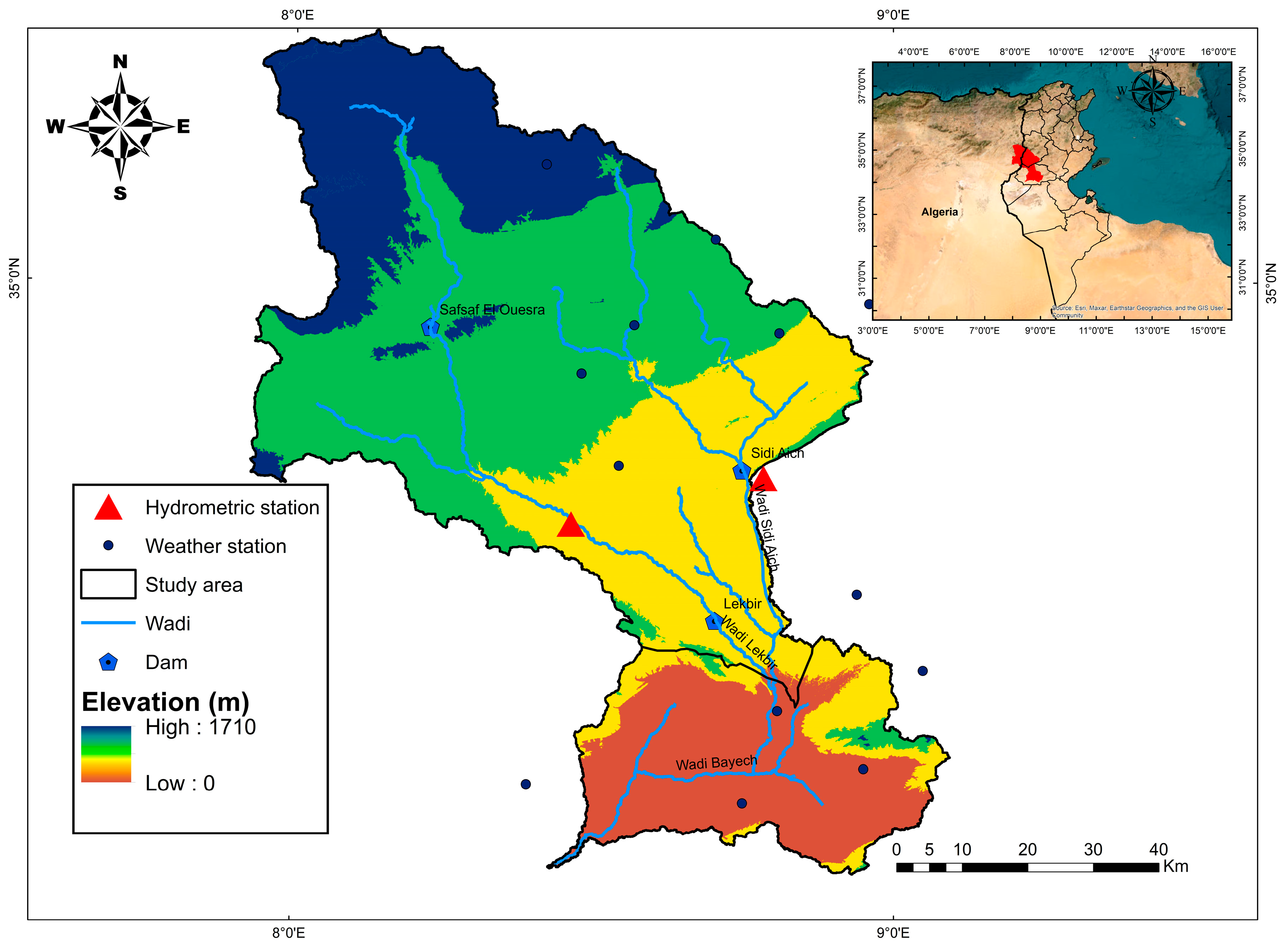
The Bayech catchment is a shared basin between Algeria (Tebessa) and Tunisia (Gafsa and Kasserine). This transboundary system covers about 6491 km2, of which 4508 km2 (69.5%) are in southwestern Tunisia.
The Bayech catchment exhibits a rapidly changing topography, and wide wadis, with indistinct channels. These wadis are frequently intersected by low-lying areas, creating a semi-endoreism that significantly disrupts the flow patterns. Flooding in this basin is primarily triggered by high-intensity storms and typically remains localized. The slope configuration and soil composition can facilitate swift surface runoff during heavy rainfall (Figure 1).

Figure 1.
Study area map.
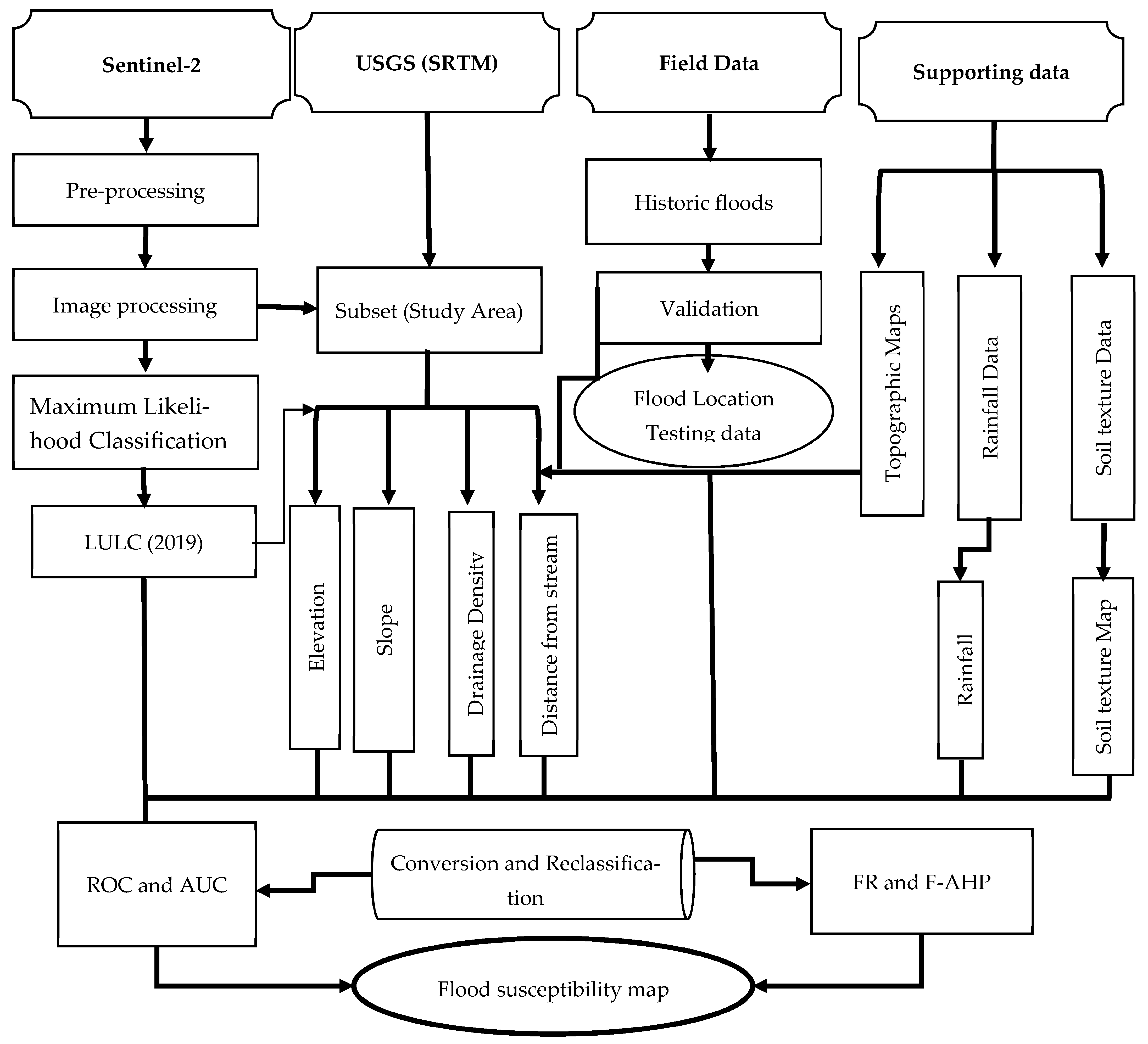
The methodology, adopted to identify flood-prone areas in the Bayech basin, is depicted in Figure 2. It is crucial to begin by defining the problem and establishing clear objectives. Given the magnitude of human and economic losses caused by flash floods, the aim of this study is to select and identify flood-prone areas within this basin. The first step involves determining relevant criteria based on a literature review. The influential criteria were standardized on a continuous scale using fuzzy logic. The second step is based on the use of both F-AHP and FR methods as a sustainability assessment tool for risk assessment. The two proposed models were subsequently validated using the ROC model.
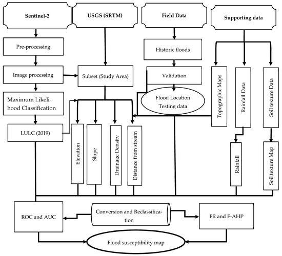
Figure 2.
Flowchart of the proposed methodology.
2.2. Flood Condition Parameters
Several studies have examined the factors closely related to the assessment of flood susceptibility in arid environments. Appendix A provides an overview of the environmental factors considered in the literature to map flood risks in these regions.
In this study, seven factors were taken into account with reference to expert opinion and available data in order to better recognize flooding prone areas. The choice of factors was made according to the specificity of climate and hydrological conditions in the Bayech catchment, namely, altitude, slope, rainfall, land use and cover, drainage density, soil texture and distance from the watercourse. The projection system used in this study area is the Degrees decimal minutes (DDM) and resampled at 30 × 30 m resolution raster maps.
Table 1 presents a summary of the generic and public data sources that were taken into account to select the database for the study.

Table 1.
Different data sources collected in the study area.
2.2.1. Elevation
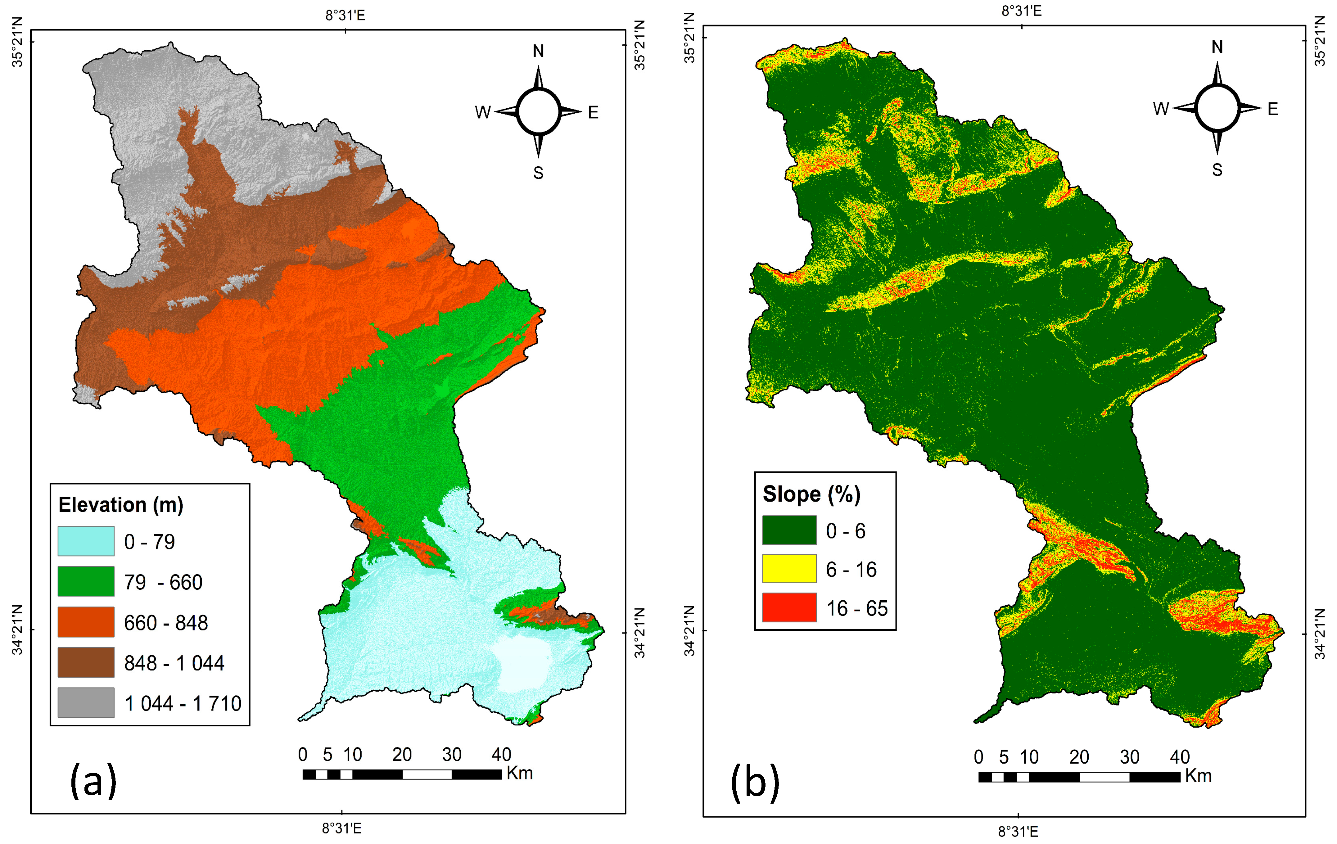
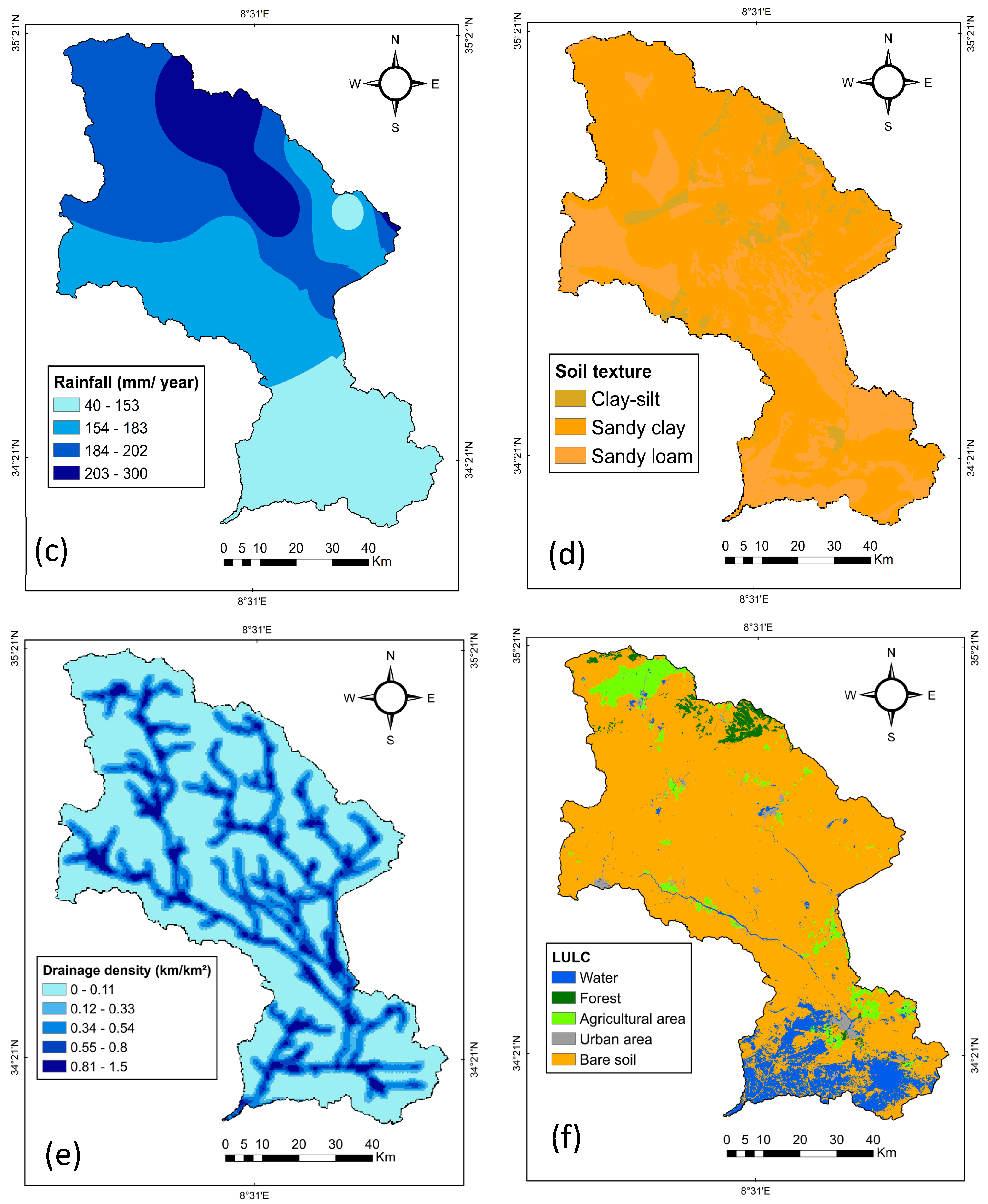
Elevation influences flood propagation and flow direction [20,21]. In this study, the elevation map was produced from the Digital Elevation Model at a spatial resolution of 30 m × 30 m, downloaded from the USGS Earth Explorer mission (https://earthexplorer.usgs.gov (accessed on 21 March 2021)) and extracted from the Shuttle Radar Topography Mission (SRTM) (See to Figure 3a).


Figure 3.
Flood conditioning factors maps: (a) Elevation map, (b) Slope map, (c) Rainfall map, (d) Soil texture map, (e) Drainage density map, (f) Land use map.
2.2.2. Drainage Density
Drainage density is one of the main factors causing flooding [22]. The higher the drainage density, the higher the run-off rate [18]. As a result, the risk of flooding is higher. The drainage density map is obtained from stream network data using the “Line density” tool (ArcGIS 10.2). Line density is calculated by dividing the total length of all streams and rivers in a catchment by the total area of the catchment (see Figure 3e).
2.2.3. Soil Texture
Soil texture is another factor that strongly controls hydrology and directly affects infiltration rates, depending on porosity and permeability [23]. The soil map used was obtained from the Tunisian agricultural map (CRDA of Gafsa and Kasserine) and the Algerian soil map. The soil texture is of three groups: sandy clay, sandy loam, and silty clay. Sandy clay dominates most of the area (see Figure 3d).
2.2.4. Slope
The slope influences water flow velocity and controls the surface runoff infiltration [24]. The slope map was created from the Digital Elevation Model (DEM) using the surface analysis tool (ArcGIS 10.2). In the study area, the slope varies from 0 to 65%.
The areas exhibiting the highest risks are represented by lowlands with a slope less than 6% and riverbeds, while the steepest slope refers to the areas less prone to flood risks (Figure 3b).
2.2.5. Distance from the River
Lutz [25] showed that the flood risks decrease progressively as the distance from the hydrographic network increases. To obtain the distance to a river, the Euclidean distance tool (ArcGIS Toolbox) was used (Figure 4).
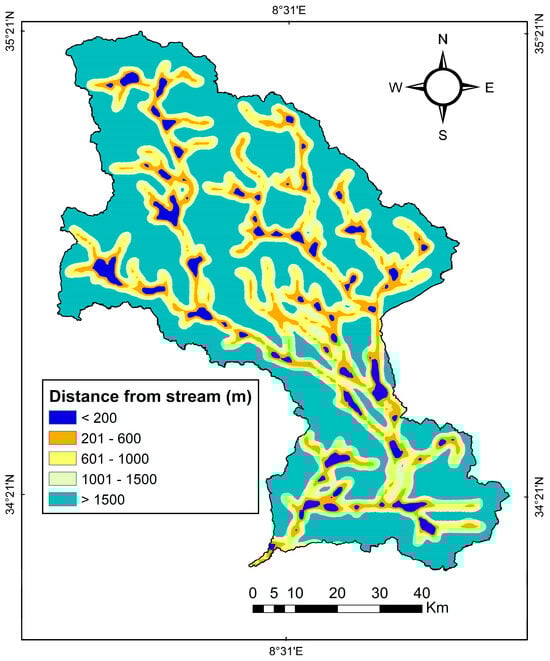
Figure 4.
Distance from stream map.
2.2.6. Land Use
Land use plays a significant role in regulating the movement of water through various processes such as runoff, infiltration, evaporation, and evapotranspiration. Consequently, it directly influences the likelihood of flooding events [26]. Land use categories encompass a wide range of factors, including soil deposits, distribution of buildings, watercourses, vegetation cover, bare land, and roads [27]. The occurrence of flooding is influenced by the specific land use patterns and its evolution over time [28]. To analyze land use, a supervised classification approach based on spectral signatures was employed. Sentinel-2 images from 2019 were acquired from the official Scihub Copernicus website. The Sentinel-2 images consisted of eleven bands (bands 1–11) with a spatial resolution of 10 m. These images were processed by enhancing their radiometric properties and then sliced using a maximum likelihood classification algorithm, employing a per-pixel classification methodology [29]. The classification method demonstrated a high overall accuracy, with a kappa coefficient of 0.90 for the year 2019 (Figure 3f).
2.2.7. Rainfall
The dataset used in this research was sourced from the hydrological services of the Gafsa and Kasserine Regional Commissariat for Agricultural Development (CRDA). To ensure the reliability and representativeness of the data, a comprehensive analysis and evaluation of the annual rainfall records were conducted. Based on their spatial distribution, 25 stations were carefully selected, which best represented the study area. The measurement period extended from 1984 to 2019. In order to achieve statistically significant results, it is essential to work with a homogeneous series of climatic data for any climatological or hydrological study. Therefore, the rainfall time-series were homogenized using the regional vector method, resulting in an operational rainfall database that can be relied upon.
Several methods were used to study rainfall variability: regional vector indices and statistical tests.Haut du formulaire The choice of mean annual rainfall from 1984 to 2019 is based on the fact that it provides a comprehensive representation of rainfall patterns over an extended period. By examining mean annual rainfall, it is possible to capture long-term climate conditions and trends, which can be very useful in understanding general rainfall patterns in the region. The pattern or trend of rainfall distribution differs from one event to another, and for this reason, the average annual rainfall in the basin is presented. The interannual rainfall average in the Bayech basin between 1984 and 2019 is about 179 mm with a maximum of 734 mm (1990) and a minimum of 4 mm (2012). According to Table 2, the wettest decade was the 1990s (348 mm), while the driest decade was the 1980s (154 mm). A downward trend in precipitation was observed between the 2000s and the 2010s.
Table 2.
The decadal statistics of rainfall in the Bayech Basin.
The study basin has witnessed numerous devastating rainfall incidents in various locations, including Gafsa and Feriana. On the 4th of October 2017, floods submerged several roads in the Gafsa governorate, leading to a complete disruption of road traffic. Specifically, Road 201, which connects Moularès to Gafsa, Road 122, linking Metlaoui to Moularès, and Regional Road 3, connecting Metlaoui to Tozeur, were all affected. Similarly, on 31 September 2019, heavy rainfall caused flooding that resulted in the blockage of Regional Road 122, affecting the towns of Om Laarayes and Metlaoui in the Gafsa governorate (see Table 3).
Table 3.
Dates and sites of floods.
The rainfall spatial variability was analyzed via ArcGIS using the Inverse Distance Weighted (IDW) interpolation method, developed in 1972, by the National Weather Service. This index is used to assign data to unknown sites on the basis of known data [30] (Figure 3c).
2.3. Fuzzy Analytical Hierarchy Process (F-AHP)
The fuzzy AHP technique is an advanced analytical method derived from the traditional AHP. It is a multicriteria method commonly used for qualitative and quantitative analysis of a hierarchical list of the most influencing factors to get insights on the decision-making process. The presence of fuzziness and vagueness in many decision-making scenarios often leads to imprecise judgments in conventional AHP approaches [31]. Consequently, several researchers (e.g., [30,32,33]) have focused on studying fuzzy AHP, an extension of Saaty’s theory, and have indicated that fuzzy AHP offers a more comprehensive description of the analyzed process than the traditional AHP method (Table 4). After calculating factor weights for each criterion, and the fuzzification of each flash flood factor, it must be multiplied by the fuzzy logic output with AHP weight output using this equation (Equation (1)) then it should be combined by the fuzzy overlay tool, to finally obtain the flash flood susceptibility map of Bayech catchment.
where:
F-AHP = ∑nin Wi × Fi
Table 4.
Membership function of linguistic scale (F-AHP).
Wi = Weight of each flash flood factor and Fi = Fuzzy map of each flash flood.
In this study case, the F-AHP calculation is:
F-AHP = 0.391 * (Fuzzy Elevation) + 0.252 * (Fuzzy Drainage Density) + 0.144 * (Fuzzy Slope) + 0.092 * (Fuzzy Distance from river) + 0.095 * (Fuzzy Land use) + 0,063 * (Fuzzy Soil texture) + 0.023 * (Fuzzy Rainfall).
2.4. Frequency Ratio Model (FR)
The frequency ratio (FR) method is widely recognized as one of the most popular statistical approaches used in mapping studies. The FR for a specific class of a flood conditioning factor is determined by calculating the ratio of the flooded points percentage within the class to the percentage of pixels representing that class in the entire domain. An FR value greater than 1 indicates a strong correlation, while a value less than 1 signifies a weak correlation [12]. The FR method is used to determine the correlation between flood special distribution and the associated factors. The influence of analyzed parameters for the flood vulnerability was assessed through the agglomeration of thematic data layers [34]. Subsequently, the frequency ratio for each factor class was computed using the procedure outlined below [35].
The frequency is determined by analyzing flood locations in relation to each of the considered factors. The FR of each factor was calculated based on its relationship with the flood inventory (Equation (2)).
In the next step, the FR was normalized in a range of probability values [0, 1] to obtain the relative frequency (RF) using Equation (3) [23].
RF = Factor class FR/∑ Factor classes FR
After normalization, the FR considered all flood factors as equally weighed. To solve this problem and find the interrelationship between flood determinants, a prediction rate (PR) was calculated by evaluating each flood determinant with the training dataset (Equation (4)) [23].
PR = (RFmax − RFmin)/(RFmax − RFmin) Min
Finally, a flood risk map was created using the sum of the PR of each factor and the RF of each class (using Equation (5)) [23]. The resulting map was reclassified into five classes: very low, low, moderate, high, and very high.
where FSI is the flood risk susceptibility index, PRi is the weight of each triggering factor, RF is the class weight of each subclass of flood triggering factor, and n is the number of factors (in this work, n = 7).
2.5. Flood Inventory Map
The flood inventory played a crucial role in both training the bivariate statistics (FR model) and verifying the accuracy of the flood susceptibility models. Fieldwork served as the primary data source for constructing the inventory map in this study (Figure 5). Based on the findings from literature reviews, a random selection process was made wherein 70% of flooded sites (represented by 50 sites) were chosen as the training dataset for developing the flood risk map. The remaining 30% of sites (represented by 25 sites) were reserved for validating the obtained results. In order to categorize the flood exposure levels, a value of 1 was assigned to areas with high flood exposure, while areas with low or no flood risk were assigned a value of 0. These methods were mentioned in several studies [23,24,36].
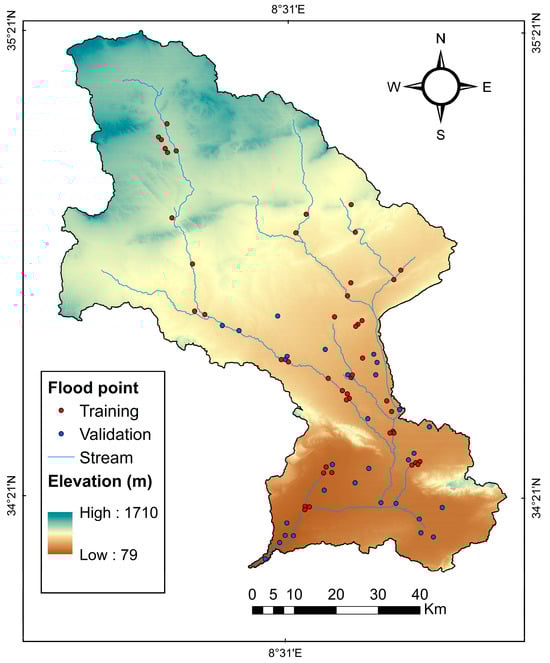
Figure 5.
Flood inventory (1984–2019) in the study area.
Validation
The results of these two proposed models were validated using ROC (Receiver Operating Characteristic) and AUC (Area under the Curve). The purpose of this validation process was to measure the agreement between the simulated flood risks (obtained by F-AHP and FR) and the observed flood risks from the inventory database, thereby assessing the accuracy of the models [35]. ROC curves, a widely used tool for accuracy assessment, provide a clear and visually appealing representation of model performance [36]. The ROC curve is constructed by plotting the true positive rate (sensitivity) on the y-axis against the false positive rate on the x-axis. The AUC, which ranges from 0.5 to 1, quantifies the accuracy of the prediction models [37]. A value of 1 indicates a perfect model, while a value of 0.5 means that it is not very useful.
3. Results
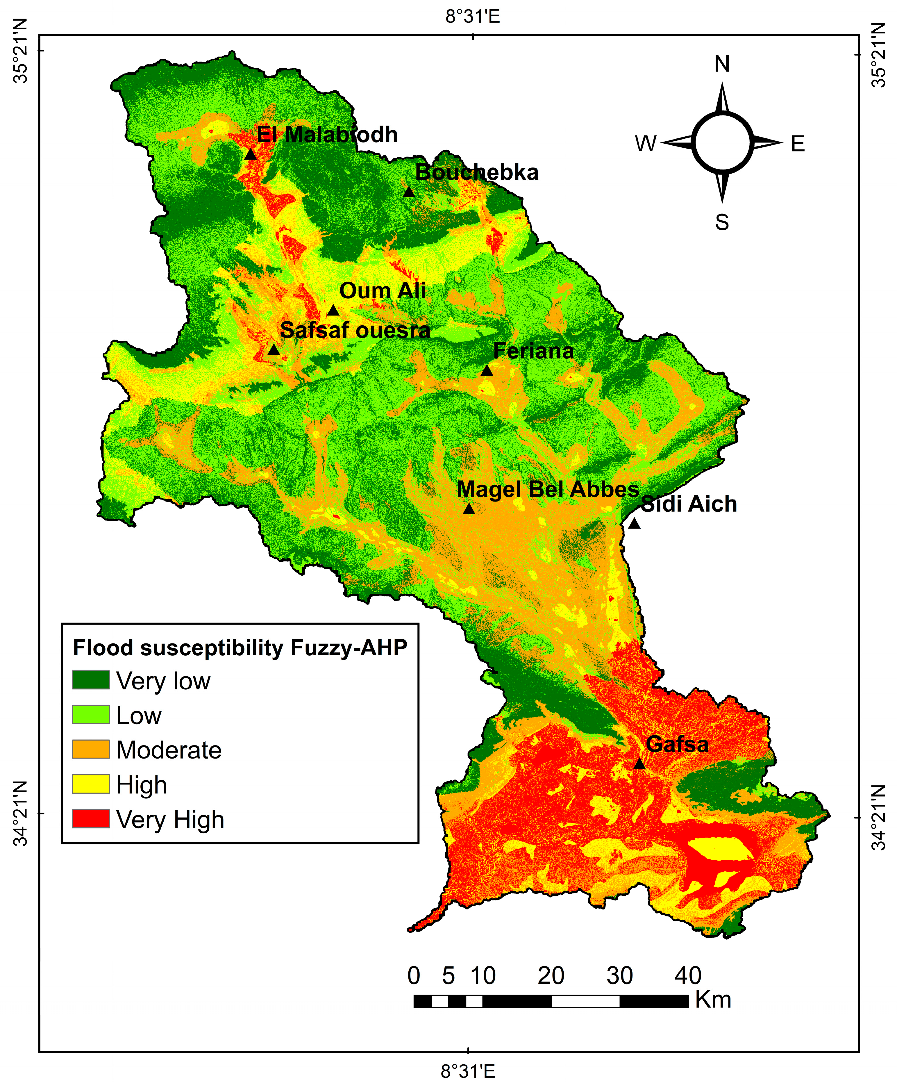
The obtained susceptibility map, derived from the F-AHP analysis shown in Figure 6, is classified into five distinct categories, reflecting varying degrees of susceptibility. Table 5 shows the weights of the factors affecting flood-risk areas in the study area.

Figure 6.
Flood susceptibility map using the F-AHP.
Table 5.
Results of weights for each sustainable factor.
The results of the F-AHP analysis indicate that impermeable areas have a moderate flood susceptibility, increasing runoff and reducing effective infiltration, whereas the majority of built-up areas fall into the very high flood susceptibility category. In addition, some smaller areas, particularly in the city of Gafsa and the northern districts, are classified into the very high susceptibility category. However, most parts of the basin fall into very low to low susceptibility to flooding. The flood risk susceptibility maps generated through the FR model demonstrated that slope had the most significant impact on flooding, as evidenced by its FR value of 2.65. In contrast, drainage density and elevation displayed moderate FR values, indicating their moderate influence on flood occurrences.
The slope of the land plays a key role in determining vulnerability to flooding due to the natural flow of water from higher to lower areas [38]. In this study, it was observed that the 0–25% slope class had the highest RF value of 0.83, indicating a strong association with flood susceptibility. Conversely, slopes above 26% had the lowest RF values of 0.16 and 0.01, as shown in Table 6. These results are consistent with previous studies, which consistently indicate a lower probability of flood susceptibility in areas with steeper slopes, while highlighting a higher probability of flooding in low-lying areas or those with gentle slopes.
Table 6.
The calculated FR and RF factors.
In this work, the slope seems to be the most dominant factor contributing to the flood risk with a PR of 2.66 followed by the drainage density (1.65), elevation (1.49), the rainfall (1.46), the land use (1.46), and the soil texture (1.47), while the distance from the stream has the least influence with a PR value of 1.32 in determining flood susceptibility in the study area (refer to Table 7).
Table 7.
PR values for all conditioning factors.
The flood susceptibility map, generated using the FR method, was classified into five susceptibility categories (very low, low, moderate, high, and very high). The resulting flood susceptibility map (Figure 7) shows that the areas characterized by very high susceptibility are mainly made up of impermeable surfaces, which prevent infiltration and encourage increased runoff.
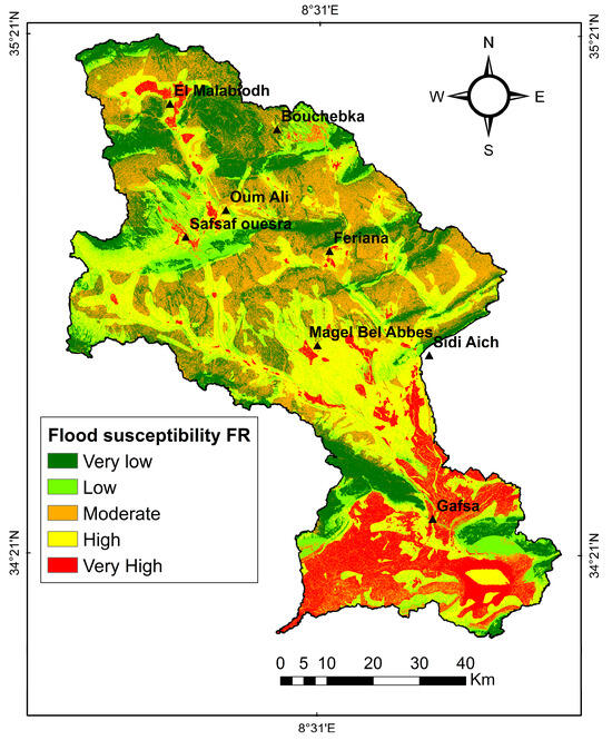
Figure 7.
Flood susceptibility map using the FR model.
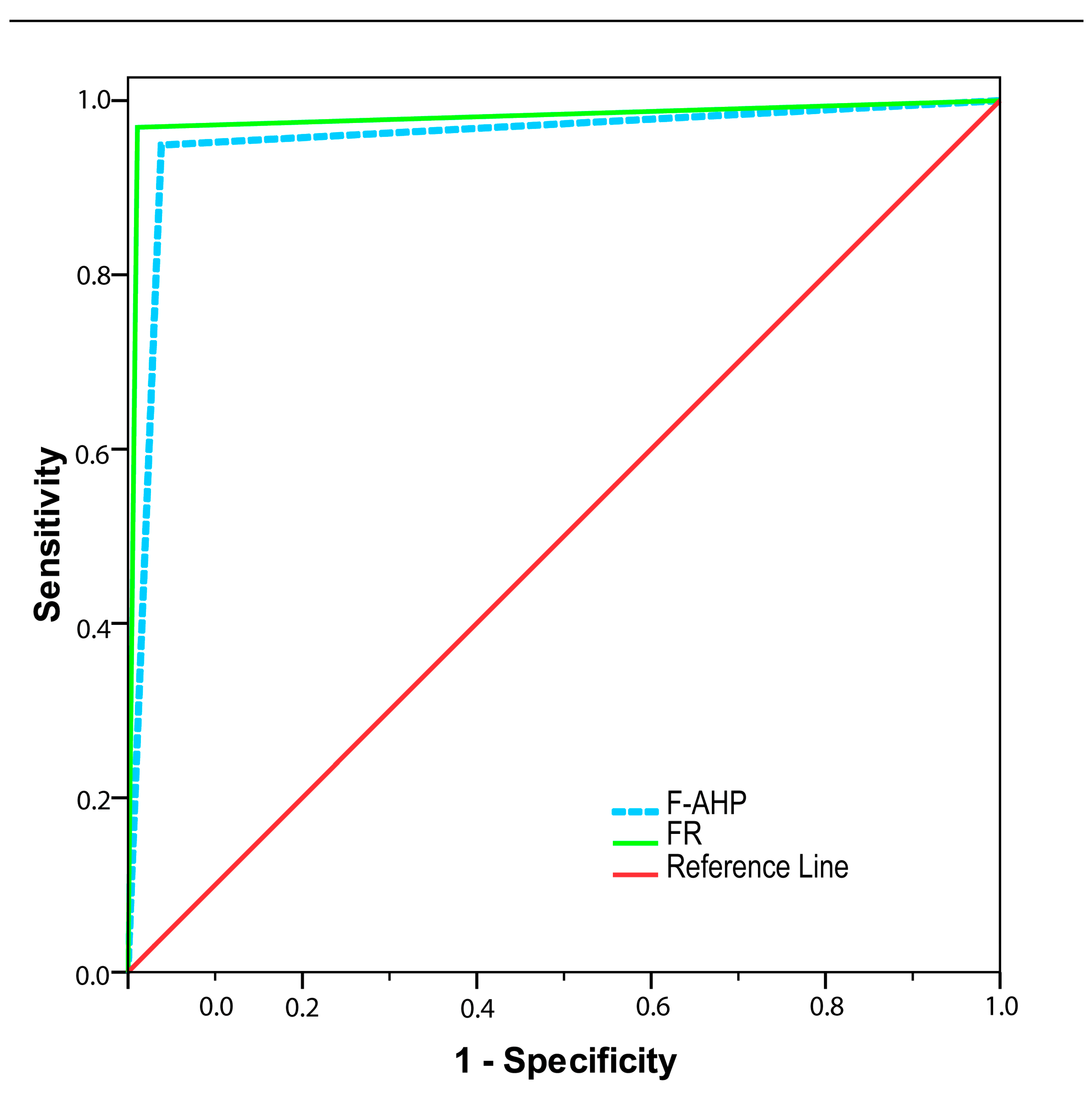
The AUC curve values for the F-AHP and FR models were 95% and 97% respectively. With regard to ROC curves, the FR model had the higher performance prediction, compared to F-AHP. According to Table 8, the FR and F-AHP models yielded similar reasonably good results. The ROC curves for the two models (F-AHP and FR) are presented in Figure 8 and Table 8 presents the ranges of AUC values along with their corresponding interpretations [39].
Table 8.
The AUC results and sensitivities obtained by F-AHP and FR.
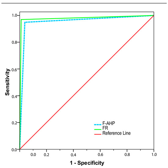
Figure 8.
Receiver Operating Characteristic (ROC) analysis of F-AHP and FR.
4. Discussion
The study was carried out in the southwest region of Tunisia, which encompasses several wadis, including Bayech, Sidi Aich, and Lekbir. As expected, the areas near these wadis were identified as being highly susceptible to flooding. The Bayech wadi is of particular concern, as it is known for its tendency to change course rapidly and trigger flash floods. The study area’s wadis have significant potential to generate recurrent flooding. The presence of areas with minimal incision in the valleys has resulted in water overflowing beyond the primary riverbed. The steep slopes in the upstream regions have effectively constrained the valleys, thereby limiting the lateral expansion of the river sections. This situation has had a significant impact on the village of Gafsa, which is the largest and most densely populated commercial center in the region, accommodating 5000 residents. The village has been heavily affected by these repetitive and extreme floods [13,38]. Agricultural villages are exposed to flooding threats, occupying the alluvial plains of various tributaries. In this study, two different models were applied to map flood susceptibility in the Bayech basin using a set of sustainability factors, including rainfall, soil texture, slope, drainage density, land cover, distance from the stream, and elevation under GIS environment. On the basis of obtained results, the FR exhibits slightly better prediction evaluation (AUC = 97%) compared to F-AHP (AUC = 95%). This result is in agreement with many previous studies, including the research of Khadraoui et al. (2022) [10]. In various research endeavors, the F-AHP methodology has been applied, as evidenced by its utilization in diverse studies. For instance, it was employed to derive a cost-effective solution for assessing urban flash flood impacts in Ras Ghareb City, Egypt, as demonstrated by Soha [16]. Similarly, the research of Hategekimana utilized this approach to establish the flood risk index in Mombasa County, Kenya, in 2018 [39]. There is also the research of Talha in Guelmim region in southwestern Morocco [11]. In this study, the adopted methodology illustrates that slope and hydrologic features reveal greater influence in determining flood susceptibility. The slope was considered the dominant controlling t for flash floods [40]. Moreover, low-quality embankment structures, deforestation at river banks, sediment deposition, and non-removal of sediment from dams are some factors that may cause floods at wadi banks.
5. Conclusions
The principal aim of this research was to assess flood susceptibility based on an examination of the two powerful F-AHP and FR models. The choice of the study area was due to its sufficient heterogeneity on the surface to be representative of a wide variety of situations, as well as the overexploitation and degradation of natural resources being linked on the one hand to high population growth and the urbanization of agricultural land, and on the other hand to the fragility of land resources. The analysis considered seven factors: land elevation, field rainfall, soil texture, slope, drainage density, land cover, and distance from the stream. Comparing the two methods, the flood susceptibility map generated by the FR model exhibited greater accuracy than that produced by the F-AHP model. The FR method demonstrated its effectiveness using only quantitative data, thus validating the reliability of the FR method.
The flood susceptibility maps generated as a part of this study can prove to be extremely valuable for preliminary investigations aimed at formulating sustainable flood prevention strategies. They can assist planners, engineers, and decision-makers in implementing suitable mitigation measures and initiatives to forestall and mitigate the impacts of future floods. Indeed, both methods used in this study gave satisfactory results in identifying flood-prone areas and can contribute to effective flood management practices. However, the frequency ratio (FR) is a frequently employed technique in bivariate statistical analysis for constructing predictive maps. However, it is worth noting that the fuzzy Analytic Hierarchy Process (F-AHP) relies on expert opinions, which can introduce subjectivity, and the FR method may not effectively address intricate problems. As a result, it may be advisable to consider employing machine learning methods for flash flood susceptibility mapping. Machine learning methods are well-suited for tackling complex problems and handling extensive datasets due to their capacity for in-depth analysis and large-scale data processing.
Author Contributions
Conceptualization, Z.A. and M.O.; Methodology, Z.A., N.D. and M.O.; Software, Z.A. and N.D. Validation, Z.A.; Formal analysis, M.O. and M.V.; Investigation, Z.A.; Resources, Z.A.; Data curation, Z.A.; Writing—original draft, Z.A., N.D., M.V. and M.O.; Writing—review and editing, M.V., A.L., M.B.Z. and A.M.; Visualization, Z.A.; Supervision, M.O. and M.V.; Project administration, M.O.; Funding acquisition, M.O. All authors have read and agreed to the published version of the manuscript.
Funding
This research received no external funding.
Institutional Review Board Statement
This study did not require ethical approval.
Informed Consent Statement
Not applicable.
Data Availability Statement
Not applicable.
Acknowledgments
This publication is associated with the PhD research conducted by the first author, which was partly funded by the MHESR of Tunisia (Contrat Programme Labo LR16IRA01) and IRA of Medenine. We would like to thank Messaoud Guied for his technical and field assistance.
Conflicts of Interest
The authors do not have any pertinent financial or non-financial affiliations to declare.
Appendix A
Summary of literature base environmental factors for modeling flood susceptibility in the semi-arid regions.
| Source (s) | [10] | [11] | [12] | [13] | [14] | [15] | [16] | [17] | |
| Name of|the Attribute | |||||||||
| Rainfall | × | × | × | × | × | × | × | × | |
| Elevation | × | × | × | × | × | × | × | × | |
| Land use/Land cover | × | × | × | × | × | × | × | × | |
| Drainage density | × | × | × | × | × | × | × | × | |
| Soil Moisture Index | × | ||||||||
| NDVI | × | ||||||||
| Hydraulic conductivity | × | ||||||||
| Flow accumulation | × | ||||||||
| Slope | × | × | × | × | × | × | × | × | |
| Groundwater level | × | × | |||||||
| Soil | × | × | × | × | × | ||||
| Curvature | × | ||||||||
| Stream power index | × | ||||||||
| Topographic wetness index | × | × | × | ||||||
| Geology | × | × | × | × | × | × | |||
| Distance from the river | × | × | × | × | × | × | |||
×: represents the parameters used in delineating flood-prone areas in the work of each author.
References
- Elahi, E.; Khalid, Z.; Tauni, M.Z.; Zhang, H.; Lirong, X. Extreme weather events risk to crop-production and the adaptation of innovative management strategies to mitigate the risk: A retrospective survey of rural Punjab, Pakistan. Technovation 2022, 117, 102255. [Google Scholar] [CrossRef]
- Abbas, A.; Waseem, M.; Ahmad, R.; Khan, K.A.; Zhao, C.; Zhu, J. Sensitivity analysis of greenhouse gas emissions at farm level: Case study of grain and cash crops. Environ. Sci. Pollut. Res. 2022, 29, 82559–82573. [Google Scholar] [CrossRef]
- Wang, Y.; Xiao, D.; Li, Y.; Li, X. Soil salinity evolution and its relationship with dynamics of groundwater in the oasis of inland river basins: Case study from the Fubei region of Xinjiang Province, China. Environ. Monit. Assess. 2008, 140, 291–302. [Google Scholar] [CrossRef] [PubMed]
- Vaidya, O.S.; Kumar, S. Analytic hierarchy process: An overview of applications. Eur. J. Oper. Res. 2006, 169, 1–29. [Google Scholar] [CrossRef]
- Chang, D.-Y. Applications of the extent analysis method on fuzzy AHP. Eur. J. Oper. Res. 1996, 95, 649–655. [Google Scholar] [CrossRef]
- Balezentiene, L.; Streimikiene, D.; Balezentis, T. Fuzzy decision support methodology for sustainable energy crop selection. Renew. Sustain. Energy Rev. 2013, 17, 83–93. [Google Scholar] [CrossRef]
- Tian, J.; Yan, Z.F. Fuzzy Analytic Hierarchy Process for Risk Assessment to General-assembling of Satellite. J. Appl. Res. Technol. 2013, 11, 568–577. [Google Scholar] [CrossRef]
- Samanta, S.; Pal, D.K.; Palsamanta, B. Flood susceptibility analysis through remote sensing, GIS and frequency ratio model. Appl. Water Sci. 2018, 8, 66. [Google Scholar] [CrossRef]
- Tehrany, M.S.; Kumar, L.; Jebur, M.N.; Shabani, F. Evaluating the application of the statistical index method in flood susceptibility mapping and its comparison with frequency ratio and logistic regression methods. Geomat. Nat. Hazards Risk 2019, 10, 79–101. [Google Scholar] [CrossRef]
- Khadraoui, N.; Dahri, N.; Bouamrane, A.; Pham, Q.B.; Abida, H. Flood susceptibility mapping using qualitative and statistical methods in a semi-arid basin: Case of the Manouba–Sijoumi watershed, Northeastern Tunisia. Acta Geophys. 2022. [Google Scholar] [CrossRef]
- Talha, S.; Maanan, M.; Atika, H.; Rhinane, H. Prediction of flash flood susceptibility using fuzzy analytical hierarchy process (f-ahp) algorithms and gis: A study case of guelmim region in southwestern of Morocco. Int. Arch. Photogramm. Remote Sens. Spat. Inf. Sci. 2019, XLII-4/W19, 407–414. [Google Scholar] [CrossRef]
- Pradhan, B.; Mansor, S.; Pirasteh, S.; Buchroithner, M.F. Landslide hazard and risk analyses at a landslide prone catchment area using statistical based geospatial model. Int. J. Remote Sens. 2011, 32, 4075–4087. [Google Scholar] [CrossRef]
- Fehri, N.; Samaali, H.; Abaza, K. Les inondations catastrophiques du 13 octobre 2007 dans le secteur de Sabbelet Ben Ammar: Entre aléa climatique et responsabilité anthropique. Rev. Tunis. Géographie 2009, 40, 31–55. [Google Scholar]
- Fehri, N. L’aggravation du risque d’inondation en Tunisie: Éléments de réflexion. Physio-Géo Géographie Phys. Environ. 2014, 8. [Google Scholar] [CrossRef]
- Inondations en Tunisie: La Vigilance Est de Mise! Available online: https://www.businessnews.com.tn/inondations-en-tunisie--la-vigilance-est-de-mise,519,83213,3 (accessed on 26 July 2023).
- Mohamed, S.A.; El-Raey, M.E. Vulnerability assessment for flash floods using GIS spatial modeling and remotely sensed data in El-Arish City, North Sinai, Egypt. Nat. Hazards 2020, 102, 707–728. [Google Scholar] [CrossRef]
- Dahri, N.; Abida, H. Causes and impacts of flash floods: Case of Gabes City, Southern Tunisia. Arab. J. Geosci. 2020, 13, 176. [Google Scholar] [CrossRef]
- SKachouri; Achour, H.; Abida, H.; Bouaziz, S. Soil erosion hazard mapping using Analytic Hierarchy Process and logistic regression: A case study of Haffouz watershed, central Tunisia. Arab. J. Geosci. 2015, 8, 4257–4268. [Google Scholar] [CrossRef]
- Dahri, N.; Abida, H. Monte Carlo simulation-aided analytical hierarchy process (AHP) for flood susceptibility mapping in Gabes Basin (southeastern Tunisia). Environ. Earth Sci. 2017, 76, 302. [Google Scholar] [CrossRef]
- Tien Bui, D.; Shirzadi, A.; Shahabi, H.; Chapi, K.; Omidavr, E.; Pham, B.T.; Talebpour Asl, D.; Khaledian, H.; Pradhan, B.; Panahi, M.; et al. A Novel Ensemble Artificial Intelligence Approach for Gully Erosion Mapping in a Semi-Arid Watershed (Iran). Sensors 2019, 19, 2444. [Google Scholar] [CrossRef]
- Rajib, A.; Liu, Z.; Merwade, V.; Tavakoly, A.A.; Follum, M.L. Towards a large-scale locally relevant flood inundation modeling framework using SWAT and LISFLOOD-FP. J. Hydrol. 2020, 581, 124406. [Google Scholar] [CrossRef]
- Falah, F.; Nejad, S.G.; Rahmati, O.; Daneshfar, M.; Zeinivand, H. Applicability of generalized additive model in groundwater potential modelling and comparison its performance by bivariate statistical methods. Geocarto Int. 2017, 32, 1069–1089. [Google Scholar] [CrossRef]
- Ullah, K.; Zhang, J. GIS-based flood hazard mapping using relative frequency ratio method: A case study of Panjkora River Basin, eastern Hindu Kush, Pakistan. PLoS ONE 2020, 15, e0229153. [Google Scholar] [CrossRef]
- Rahmati, O.; Melesse, A.M. Application of Dempster–Shafer theory, spatial analysis and remote sensing for groundwater potentiality and nitrate pollution analysis in the semi-arid region of Khuzestan, Iran. Sci. Total Environ. 2016, 568, 1110–1123. [Google Scholar] [CrossRef] [PubMed]
- Fernández, D.S.; Lutz, M.A. Urban flood hazard zoning in Tucumán Province, Argentina, using GIS and multicriteria decision analysis. Eng. Geol. 2010, 111, 90–98. [Google Scholar] [CrossRef]
- Alexakis, D.D.; Grillakis, M.; Koutroulis, A.; Agapiou, A. GIS and remote sensing techniques for the assessment of land use change impact on flood hydrology: The case study of Yialias basin in Cyprus. Nat. Hazards Earth Syst. Sci. 2014, 14, 413–426. [Google Scholar] [CrossRef]
- Al-shabeeb, A.R. The Use of AHP within GIS in Selecting Potential Sites for Water Harvesting Sites in the Azraq Basin—Jordan. J. Geogr. Inf. Syst. 2016, 8, 73–88. [Google Scholar] [CrossRef]
- Akay, H. Flood hazards susceptibility mapping using statistical, fuzzy logic, and MCDM methods. Soft Comput. 2021, 25, 9325–9346. [Google Scholar] [CrossRef]
- Dubois, D. Evaluation and decision models: A critical perspective. Fuzzy Sets Syst. 2003, 139, 469–472. [Google Scholar] [CrossRef]
- Mikhailov, L. Deriving priorities from fuzzy pairwise comparison judgements. Fuzzy Sets Syst. 2003, 134, 365–385. [Google Scholar] [CrossRef]
- Baalousha, H.M.; Younes, A.; Yassin, M.A.; Fahs, M. Comparison of the Fuzzy Analytic Hierarchy Process (F-AHP) and Fuzzy Logic for Flood Exposure Risk Assessment in Arid Regions. Hydrology 2023, 10, 136. [Google Scholar] [CrossRef]
- Lee, S.; Pradhan, B. Probabilistic landslide hazards and risk mapping on Penang Island, Malaysia. J. Earth Syst. Sci. 2006, 115, 661–672. [Google Scholar] [CrossRef]
- Mersha, T.; Meten, M. GIS-based landslide susceptibility mapping and assessment using bivariate statistical methods in Simada area, northwestern Ethiopia. Geoenvironmental Disasters 2020, 7, 20. [Google Scholar] [CrossRef]
- Khosravi, K.; Nohani, E.; Maroufinia, E.; Pourghasemi, H.R. A GIS-based flood susceptibility assessment and its mapping in Iran: A comparison between frequency ratio and weights-of-evidence bivariate statistical models with multi-criteria decision-making technique. Nat. Hazards 2016, 83, 947–987. [Google Scholar] [CrossRef]
- Falah, F.; Rahmati, O.; Rostami, M.; Ahmadisharaf, E.; Daliakopoulos, I.N.; Pourghasemi, H.R. Artificial Neural Networks for Flood Susceptibility Mapping in Data-Scarce Urban Areas. In Spatial Modeling in GIS and R for Earth and Environmental Sciences; Elsevier: Amsterdam, The Netherlands, 2019; pp. 323–336. [Google Scholar] [CrossRef]
- Tehrany, M.S.; Pradhan, B.; Jebur, M.N. Spatial prediction of flood susceptible areas using rule based decision tree (DT) and a novel ensemble bivariate and multivariate statistical models in GIS. J. Hydrol. 2013, 504, 69–79. [Google Scholar] [CrossRef]
- Nachappa, T.G.; Piralilou, S.T.; Gholamnia, K.; Ghorbanzadeh, O.; Rahmati, O.; Blaschke, T. Flood susceptibility mapping with machine learning, multi-criteria decision analysis and ensemble using Dempster Shafer Theory. J. Hydrol. 2020, 590, 125275. [Google Scholar] [CrossRef]
- Bouamrane, A.; Bouamrane, A.; Abida, H. Water erosion hazard distribution under a Semi-arid climate Condition: Case of Mellah Watershed, North-eastern Algeria. Geoderma 2021, 403, 115381. [Google Scholar] [CrossRef]
- Hategekimana, Y.; Yu, L.; Nie, Y.; Zhu, J.; Liu, F.; Guo, F. Integration of multi-parametric fuzzy analytic hierarchy process and GIS along the UNESCO World Heritage: A flood hazard index, Mombasa County, Kenya. Nat. Hazards 2018, 92, 1137–1153. [Google Scholar] [CrossRef]
- Souissi, D.; Zouhri, L.; Hammami, S.; Msaddek, M.H.; Zghibi, A.; Dlala, M. GIS-based MCDM–AHP modeling for flood susceptibility mapping of arid areas, southeastern Tunisia. Geocarto Int. 2019, 35, 991–1017. [Google Scholar] [CrossRef]


Disclaimer/Publisher’s Note: The statements, opinions and data contained in all publications are solely those of the individual author(s) and contributor(s) and not of MDPI and/or the editor(s). MDPI and/or the editor(s) disclaim responsibility for any injury to people or property resulting from any ideas, methods, instructions or products referred to in the content. |
© 2023 by the authors. Licensee MDPI, Basel, Switzerland. This article is an open access article distributed under the terms and conditions of the Creative Commons Attribution (CC BY) license (https://creativecommons.org/licenses/by/4.0/).