Article

Revealing the Environmental Characteristics of Towns in the Middle Himalayas Using a Geographic Information System and Self-Organizing Map

1
College of Tourism and Urban-Rural Planning, Chengdu University of Technology, Chengdu 610059, China
2
Research Center for Human Geography of Tibetan Plateau and Its Eastern Slope, Key Research Base of Humanities and Social Sciences of Colleges in Sichuan Province, Chengdu 610059, China
3
College of Earth Science, Chengdu University of Technology, Chengdu 610059, China
*
Author to whom correspondence should be addressed.
Sustainability 2023, 15(20), 15110; https://doi.org/10.3390/su152015110
Submission received: 10 July 2023 / Revised: 1 September 2023 / Accepted: 13 September 2023 / Published: 20 October 2023
(This article belongs to the Special Issue Climate Change Adaptation for Urban Areas)

Abstract

:
Through long-term interactions with the natural environment, the ethnic groups in the mid-Himalayas have formed unique urban environmental characteristics. Effectively identifying urban environmental characteristics is a prerequisite for implementing sustainable urban management strategies. This study took 194 towns in the mid-Himalayan as the research objects. GIS was used to statistically analyze the terrain, climate, soil, and other environmental characteristics of the towns. The SOM (Self-organizing map) method was used to classify the comprehensive environmental characteristics of the towns. The results show that the main urban environmental characteristics in this area are low-altitude towns account for a large proportion, gentle-slope towns account for a small proportion, rainfall is mainly 125–265 mm, vegetation cover is dominated by high-coverage towns, mainly distributed in central and southern parts, the soil is dominated by embryonic soil and alluvial soil. The SOM method overcomes the subjectivity and low degree of automation in traditional research on urban environmental characteristics using threshold indicator methods or feature interpretation methods. Based on environmental characteristics, the towns were divided into six categories, and the classification results showed a distinct north–south zonal distribution pattern. There were significant differences in the environmental characteristics of towns in different clusters, such as the towns in cluster 5 had high altitudes, low rainfall, and low vegetation coverage, while the towns in cluster 2 had low altitudes, high rainfall, and high vegetation coverage. Finally, based on the SOM clustering results, governance strategies were proposed for towns in different clusters to cope with climate and environmental changes and promote sustainable development in the mid-Himalayan.

1. Introduction

The complex mountain habitats in the middle reaches of the Himalayas have nurtured many distinctive ethnic minorities and indigenous cultures [1,2]. The long history of harmonious coexistence between man and nature has formed the World Heritage landscape belt around the Himalayas, which is a microcosm of the Himalayan cultural and geographical landscape system [3]. As the region’s core, the geographical distribution of towns is the continuous interaction between socioeconomic culture and the natural environment [4,5,6]. In the long-term interaction with the natural environment, different ethnic groups in the mid-Himalayan region have formed unique ethnic cultures [7,8]. In areas where ethnic groups congregate, the different ethnic cultures make the environmental characteristics of the towns of each ethnicity have different characteristics [9]. The formation of the town’s environmental characteristics is the result of the combined effects of nature, culture, history, economy, and other factors, which support the production and living activities of people of all ethnic groups [10,11,12]. Therefore, analyzing the town’s environmental characteristics in the mid-Himalayan region and studying the regional characteristics of the town environment will promote the healthy and sustainable development direction and model of towns in this region.
Current research on town environmental characteristics mainly focuses on the ecological environment and urbanization [13,14,15], town spatial layout, and geographical conditions [16,17,18]. For example, Zhang et al. studied new urbanization from the perspective of land transfer [19]. Saadi et al. determine the proportion of ecovillages based on the inhabitants’ preferences for France’s geographical location [20]. At the same time, the analysis of large-scale human settlement environmental characteristics has gradually become a research hotspot, such as Jia et al. confirmed the influence of geographical, environmental characteristics on the division of Tibetan settlements in China [21], G Zhou et al. revealed the intrinsic mechanism of natural geographical environment on the evolution of settlement layout [22]. Overall, the existing studies are mainly based on islands, mountains, and basins [23,24,25]. Affected by the intertwined influence of special natural geography and humanistic environment, the town environment types in the mid-Himalayan region are complex and diverse [3]. Under the interaction of various internal and external factors, such as global climate change and human activities [26], the towns in this region are undergoing a series of transformations and reconstructions, such as the reorganization of socioeconomic forms and the enhancement of regional functions. However, the effective identification of differences in town environmental characteristics is a prerequisite for the implementation of regulatory models and sustainable strategies [27,28,29].
At present, research methods have gradually shifted to modern spatial information technology and mathematical model analysis [30,31], mostly using GIS spatial analysis and metric models as the main methods [32,33,34]. However, current studies mostly use indicator thresholds or expert interpretation to identify differences in town environments [35,36,37]. The design of indicator thresholds or interpretation rules relies too much on the expert’s understanding of regional laws and has low versatility and automation, which can easily lead to large uncertainties in classification results [38,39]. Multivariate statistical methods (CA and PCA) cannot simultaneously reveal the correlation and classification of different variables and samples, especially for high-dimensional and complex data sets. To overcome the subjectivity and low automation of methods based on indicator thresholds or feature interpretation, some scholars have proposed unsupervised classification methods based on self-organizing feature mapping neural network (SOFM) models and clustering methods [40,41,42]. Unsupervised classification models can divide a large number of unlabeled samples into several categories according to the “birds of a feather flock together” principle, based on the similarity of their data features [43,44]. Since the town environment is the result of many driving factors, the use of GIS and SOM can quickly integrate terrain, climate and soil, water and land transport conditions, and other environmental factors to effectively identify town environmental characteristics.
Therefore, taking the central Himalayan region as the main research area, this paper analyses the influence of topographic environment, climate, soil, and transport conditions on the formation, development, and spatial pattern of towns in this region based on quantified data of town geographical and environmental characteristics. Furthermore, the environmental differences of towns in the central Himalayan region are revealed by using SOM to propose a governance framework adapted to climate and environmental changes.

2. Materials and Methods

2.1. Study Area

The main study area of this paper covers the southern foothills of the Himalayas and the Mt. Qomolangma National Nature Reserve in China (Figure 1). Part of the study area is in Nepal, a landlocked country in South Asia, bordering China’s Tibet on the north and India on the other three sides. According to the natural conditions, Nepal can be divided into three regions: the northern high mountains, the central temperate valleys, and the southern subtropical plains [45]. Nepal’s climate varies greatly from south to north. The lowest winter temperature in the north is −40 °C, and the highest summer temperature is 45 °C. Due to the influence of the terrain, there is also a large difference in rainfall between the northern and southern regions of Nepal [46]. Most of the rainfall occurs in the southern plains and central valleys, which are topographically low. When warm and humid air currents reach the northern high mountains, the moisture content is very low, and precipitation is difficult to form. As a result, Nepal’s agricultural land is concentrated in the southern plains and a few central valleys. Nepal’s economy is dominated by agriculture with relatively backward infrastructure [47]. Another part of the study area is the Mt. Qomolangma National Nature Reserve in Tibet, China, with an average altitude of over 4800 m. The vertical zonation of the mountains is significant. The southern mountains block the warm and humid air currents from the Indian Ocean and form a large amount of precipitation at the foot of the slopes [48], resulting in rich vegetation types in the southern mountains. The erosion of mountain valleys, rivers, and alpine glaciers has created deep river valleys and complex landforms [49,50].

2.2. Data Sources and Processing

The DEM data are from the Geospatial Data Cloud (http://www.gscloud.cn/ (accessed on 10 January 2022)) with a spatial resolution of 30 m, and the slope and slope change data are derived from the DEM; the annual mean precipitation and annual maximum precipitation data have a resolution of 250 m and are from the NOAA Global Environment NASA MOD13Q1 dataset (https://modis.gsfc.nasa.gov/ (accessed on 10 January 2022)); the land cover data are from the GlobeLand30 Global Geographic Information Public Product (National Geomatics Center global land cover data product service website www.webmap.cn (accessed on 10 January 2022)) and the land cover dataset types include: cropland, forest, grassland, shrubland, wetland, water body, moss land, artificial surface, bare land and glaciers and permanent snow. The NDVI vegetation cover data are from NASA (https://modis.gsfc.nasa.gov/ (accessed on 10 January 2022)) MOD13Q1 data with a time interval of 16 days for the whole year 2020, processed using ENVI and ArcGIS software, and the NDVI value for the study area is obtained by composing the maximum value, ranging from 0 to 1. The soil type data are obtained from the World Soil Database; the distance to river and road are extracted from the vector data of rivers and roads, which can be obtained using proximity analysis in the Spatial Analyst Toolbox of ArcGIS.

2.3. Method

The study area spans high mountains, valleys, and plains from north to south, with climate changing rapidly with altitude over relatively short horizontal distances, as do hydrology, vegetation, ecological conditions, and the socioeconomic environment. This rapid environmental change, in turn, affects culture and town society. There is enormous heterogeneity in rainfall, vegetation, and human livelihoods from north to south and east to west. At the local scale, the distribution of towns has a very close relationship with the natural environment, specifically manifested in the fact that the location, morphology, and distribution of towns are influenced or even controlled to varying degrees by natural environmental factors such as climatic conditions, geomorphological characteristics, and river network patterns. Therefore, this paper first obtained information on nine environmental factors, including elevation, slope, precipitation, and land cover for 194 towns using ArcGIS 10.2, and then statistically analyzed the number of towns at different intervals, which tentatively revealed the environmental characteristics of town distribution.
The SOM (Self-organizing map) analysis was then performed using the Kohonen package in R (Figure 2). The training size of the neural network was 194, each with 6 types of environmental factor data. In this study, the initial value of map size was first estimated using the Vesanto formula 5 n (where n is the number of samples), and then the optimal map size was determined according to the minimum values of quantization error (QE) and topographic error (TE) [51]. QE is used to measure the average distance between each data vector and the best-matching neuron, and TE measures the accuracy of the map in preserving the topology of the data. The SOM network cannot automatically determine the optimal number of classifications, so clustering methods must be combined to achieve a scientifically sound spatial clustering effect. In this study, the k-means method was used in combination with the Davies–Bouldin Index (DBI) to determine the optimal number of clusters. That is, k-means clustering trials were first performed based on different numbers of categories, usually from 2 to N, where N is the number of samples of all input data, and finally, the Davies–Bouldin index was used to determine the optimal number of clusters [52].

3. Result

3.1. Analysis of Town Environmental Characteristics Factors

As shown in Figure 3 and Table 1, we have summarized the basic information of elevation, slope, rainfall, and soil for the towns. Firstly, the classification criteria for altitude levels and slope gradient levels are jointly developed by the International Organization for Standardization (ISO) and the International Civil Aviation Organization (ICAO). The analysis shows that there are 45 towns in the plains (0–499 m), 49 towns in the low mountains (500–2499 m), and 28 towns in the middle mountains. The towns within these three altitude ranges account for 77.7% of the total number of towns. There are 55 towns on flat slopes (0–5°), 32 towns on gentle slopes (6–15°), and 52 towns on steep slopes (16–25°). The towns within these three slope ranges account for 68.4% of the total number of cities.
The analysis of the average annual rainfall shows that there are 18 towns with rainfall of 161.1–265.3 mm, 59 towns with rainfall of 125.0–161.1 mm, and 46 towns with rainfall of 86.0–125.0 mm. These three intervals represent 63.4% of the total number of towns. We reclassified the vegetation cover values into five levels: 0–0.2, 0.2–0.4, 0.4–0.6, 0.6–0.8, and 0.8–1.0, representing low coverage, medium–low coverage, medium coverage, medium–high coverage, and high coverage, respectively. There are 108 towns with high coverage, distributed in the central and southern parts of the study area, where there are dense forests, vast grasslands, and fertile farmlands. There are 37 towns with medium–high coverage, 13 with medium coverage, 16 with medium–low coverage, and 20 with low coverage. These towns are in the northern part of the study area, where the altitude is high, the temperature is low, and the rainfall is low, which is unsuitable for the growth of herbaceous vegetation.
In terms of soil types, there are three towns dominated by low activity, highly acidic soil, and 104 towns dominated by embryonic soil located in the central part of the study area, which is the valley and mountainous areas of Nepal. There are 26 towns dominated by alluvial soil, which is formed by the transport and deposition of rivers downstream. There are two towns dominated by glacial soils located in the northern part of the study area where the altitude is high, and the temperature is low, making it unsuitable for cultivation. There are 50 towns dominated by shallow soils located in the central and northern parts of the study area. One town is dominated by black soil, which has very high soil fertility. Eight towns are dominated by loose–rocky soils adjacent to alluvial soils, which also have relatively fertile soils suitable for cultivation.
Furthermore, in terms of land cover types of towns, there are 61 towns dominated by cropland, which are mainly located in the central and southern parts of the study area, where the terrain is relatively flat, and the soil is fertile, which is the main cultivation area in Nepal. There are 102 towns dominated by forest, grassland, and shrubland, indicating that the region is covered by dense forests and extensive grasslands. Four towns are dominated by artificial surfaces, including Kathmandu, the capital of Nepal. There are three towns dominated by glaciers and permanent snow, located in the central and northern parts of the study area, where the altitude is high, and towns are sparsely distributed. There are 22 towns dominated by bare land, also distributed in the central and northern parts of the study area, where natural conditions are poor, making it difficult to develop agriculture and livestock. Two towns are dominated by water bodies located around large lakes and rivers.

3.2. SOM Clustering of Town Environmental Characteristics

The dataset of geographical and environmental factors of the 194 cities was used as training data for the SOM network to obtain the U-matrix of each feature parameter. The distance between each grid node and its neighbors is represented by different colors, where each hexagon represents a neuron in the component plane. Areas with low neighbor distances indicate a group of similar nodes, while areas with high neighbor distances indicate greater differences between nodes. The parameters obtained from the SOM were clustered twice. First, the optimal number of clusters was calculated as six by Davies–Bo. Then, after two rounds of iterative training and continuously changing the neuron center nodes, the six feature parameters were finally divided into 6 clusters (Figure 4).
Based on the SOM results, we used GIS to show the distribution of cities in different geographical environment combinations. We found that the cities have an obvious north–south zonal distribution pattern, which reflects the regional differences in the living environment shaped by geographical differences. From north to south, the clustering results of cities according to environmental characteristics are cluster 5, cluster 4, cluster 6, cluster 1, cluster 3, and cluster 2. Combining Figure 5, we can identify the main environmental characteristics of the different clustered cities. For example, the cities in cluster 5 generally have higher altitudes but lower precipitation and vegetation cover. The cities in cluster 2 have extremely low altitudes and slopes, but higher precipitation and vegetation cover. Cluster 3 is similar to cluster 2, with relatively low altitude and high vegetation cover, but the slope of cluster 3 is significantly higher than that of cluster 2. Cluster 1 has lower altitudes but higher slopes and higher vegetation cover. Cluster 4 has a high altitude, high slope, low precipitation, and vegetation cover. Cluster 6 is similar to cluster 4 but has higher altitudes and slopes than cluster 4.

4. Discussion

4.1. Influence of Different Environmental Factors on Towns

The phenomenon of building cities against mountains is quite common in Nepal. The livelihood pattern of relying on mountains and slopes is based on natural geographical considerations. The middle and high mountainous areas of northern Nepal and the southern Mt. Qomolangma Protected Area have very high altitudes, cold climates, and barren lands, resulting in a relatively sparse distribution of towns [45,46]. The distribution of these towns reflects the selection of the geographical environment by the ancient people. Southern Nepal has relatively lower elevations, a suitable climate, and the ability to withstand certain natural disasters. The fertile land provided agriculture to ensure a normal life for the ancient people. Thus, ancient settlements were mostly located in southern Nepal [47,48]. The slope reflects terrain variations and affects human production activities and land suitability for cultivation [54].
Due to the lack of arable land, towns are mostly built against mountains and follow the terrain, showing a high degree of conformity with the natural environment. Arable land is fundamental to the survival of villages. A full sense of settlement and habitation is not established until agriculture becomes the dominant economic form. However, arable land is limited to relatively small areas at low altitudes where the heat allows crops to be grown [55,56]. The distribution of arable land is also constrained by the slope of the terrain and surface materials. The complex and rugged terrain makes it difficult to effectively fix soil, store fertilizer, and retain water if slopes are too steep [57]. Only relatively flat river valleys and basins have suitable soil conditions for cultivation. Coupled with the relatively dry climate, the development of agriculture also requires accessible irrigation conditions. Influenced by these factors, most arable land is concentrated in the river valleys of central Nepal [49,50]. Within the study area, the regions with the best cultivation conditions are in the southern plains. The generally suitable cultivation areas are in the central–southern river valleys. About 30% of the uncultivable land is in the northern highlands and the southern Mt. Qomolangma, where natural conditions are harsh, but there are still a significant number of towns.
River systems have had an important influence on the location and distribution of regional cities. On the one hand, the rivers provide water sources for life and production in the cities, allowing for more developed agriculture, which in turn creates the conditions for population aggregation [58]. On the other hand, rivers also provide the material basis for town development. Large cities are basically distributed along rivers [59]. The road network plays a crucial role in the economic development of a region. For a region to engage in cultural exchange and business with outside areas and to expand markets, it must improve the connectivity of its road network. Only with transport links can stable economic relationships be established [60]. The clear majority of settlements are located close to the road network, which provides links and trade with the outside world. It is only with these links that settlements can continue to aggregate and develop into cities [61].

4.2. Combined Influence of Environmental Factors on Towns

The results of the SOM analysis show that factors such as topography, soil, climate, and agricultural practices influence the distribution of cities. We also created a correlation heat map of the geographic environmental factors. The results show significant correlations between the factors. For example, the correlation coefficient between vegetation cover and rainfall is 0.65, showing a clear positive correlation. The correlation coefficient between altitude and precipitation is −0.72, indicating a significant negative correlation (Figure 6); this also shows that cities are influenced by the combined effects of environmental factors.
The SOM results show an obvious north–south zonal distribution pattern of towns, reflecting regional differences in settlement environments in the mid-Himalayas, which are shaped by geographical differences [1,2]. The distribution of clusters shows the spatial patterns of different ethnic groups adapting to the natural environment and forming ethnic settlement characteristics. In the early development stage of civilization in the mid-Himalayas, constrained by lower productivity, the ability to transform the natural environment was weak. Therefore, the choice of a habitable place was one of the basic principles for survival [4,5,6]. Settlement required the selection of regions with relatively superior natural and geographical environments. The northern Himalayan slopes are dominated by subtropical arid and semi-arid climates with plateau lacustrine basins [45], resulting in a sparser distribution of towns. The southern Himalayan slopes and Nepal River valleys are the regions with the best natural environment, relatively better natural geographic climate, suitable temperatures, landforms, and topography, providing superior natural conditions for crop growth [49,50]. Agricultural development led to a more concentrated population in this region; thus, towns were established in areas with more concentrated populations [47]. In selecting locations for town settlements, the ancestors valued both macro-level and micro-level geographic space choices, taking full account of natural geographic and environmental factors, especially highland climatic characteristics such as temperature, precipitation, and monsoons.

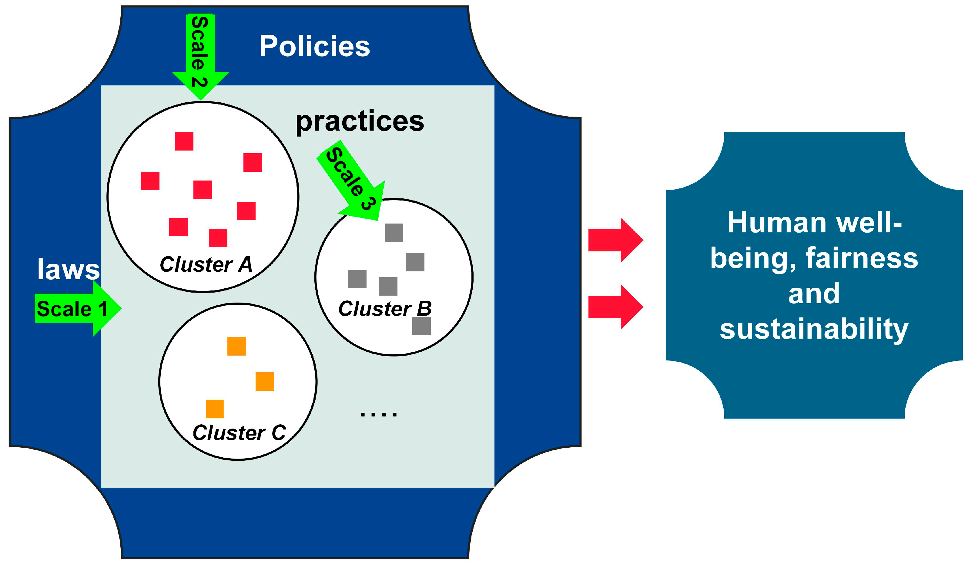
4.3. Policy Implications

Spanning the Himalayas, Sagarmatha National Park is a world-renowned high-altitude ecological tourism destination. Although China and Nepal have significant differences in the establishment of protected areas, the towns on the northern and southern slopes of Mt. Qomolangma have formed a shared regional cultural value. This region collectively provides spiritual enjoyment for visitors, including aesthetics and religious fulfillment. Formulating differentiated adaptation strategies based on the clusters and establishing a multidimensional governance framework that adapts to climate and environmental change by integrating multiple stakeholders is an effective strategy [62]. Currently, various adaptation strategies exist at national and sub-national levels through policies, plans, and projects. Most national adaptation projects and plans include watershed management, climate-smart agriculture, improving access to information for decision making, and disaster risk reduction [63]. This study has shown that the spatial distribution and economic production of mid-Himalayan towns are influenced by the geographical environment. Adapting to climate and environmental change and achieving sustainable development of human settlements in this region will become important issues. The clustering results of town environments in this study will facilitate the implementation of sustainable environmental policies in this region. For example, for cluster 3 cities with low elevation and high vegetation cover, we suggest strengthening policy support for the ecological tourism economy. Since the 1980s, the northern and southern slopes of Mt. Qomolangma have gradually become world-renowned trans-Himalayan ecological tourism destinations. The city of Shigatse on the northern slope is actively promoting Mt. Qomolangma ecotourism. Ecotourism in Sagarmatha National Park on the southern slope has also become an important pillar of local economic and social development. The Everest Base Camp Trek (EBC) in Sagarmatha National Park and the East and North Faces of Everest Trek (ENFE) in Mt. Qomolangma Nature Reserve are world-renowned high-altitude trekking routes [64]. Based on the research results, we propose sustainable development suggestions for towns at different scales (Figure 7): at the study area scale, promoting cross-border cooperation between national parks and nature reserves of China and Nepal, and promoting sustainable development of the Mt. Qomolangma region. At the cluster area level, we suggest improving the co-construction and co-management of national park protected areas and town communities, ameliorating the socioeconomic status and outdated production and living habits of the communities, and improving the way resources are utilized. Community resource management plans should be formulated to determine the management methods for natural resources and propose reasonable development initiatives. Under the coordination of co-management committee members, protected area organizations should formulate community resource management plans and promote the implementation by communities. Since each town has a different geographical location and economic development status, the management goals are different for each town. Before the project was launched, a few typical towns were selected from each cluster as pilot communities to implement co-management, accumulate experience, and promote it to the entire community, so that biodiversity conservation and economic development can achieve harmonious unity.

4.4. Limitations and Shortcomings

In this study, we analyzed the environmental characteristics of towns in the mid-Himalayan region using GIS and SOM and classified them according to their comprehensive environmental features. The classification results reflect the characteristics of the towns very well. BBased on the classification results, we proposed to formulateformulating adaptive environmental policies for towns in different clustering areas. However, due to the limitations of the research data sources, we lack more detailed investigations on the socioeconomic environment of the towns. In our follow-up studies, we will select typical towns in the study area and collect higher-resolution social and natural environmental data through questionnaires and environmental sampling devices, to propose more targeted environmental policies.

5. Conclusions

Based on GIS and SOM methods, this study analyzed the environmental characteristics of towns in the middle Himalayas. The results show that in the settlement site selection decisions, towns in the middle Himalayas chose sites on gentle slopes or terraces near rivers. Due to the lack of cultivated land, towns are mostly located against the mountain, following the terrain, showing a high degree of fit with the natural environment. The choice of town settlement sites not only pays attention to the selection of macro location, but also highly values the selection of micro geographical space, fully considering its natural geographical and environmental factors, especially the characteristics of climate such as temperature, precipitation, and monsoon. The results of SOM show that the towns have an obvious north–south zonal distribution spatiaal structure. The differences in geographical environment shaped the spatial differences in the human settlement environment of towns in the middle Himalayas and further influenced all aspects of politics, economy, culture, and society in this area, forming a unique human settlement system. Adapting to climate and environmental change and achieving sustainable development of the human settlement environment in this region will become an important issue. Attempting to establish a multidimensional governance framework adapting to climate and environmental change is an effective strategy for integrating multiple stakeholders.

Author Contributions

A.K.: writing—original draft preparation, writing—review and editing, and project administration. Q.X.: methodology, software, investigation, data curation, and conceptualization. X.Y. (Xiao Yang): validation, resources. H.X.: formal analysis. X.Y. (Xiaoxiang Yu): visualization. H.H.: supervision. A.K.: funding acquisition. All authors have read and agreed to the published version of the manuscript.

Funding

The National Social Science Foundation of China (NO.21XXW001), 2023 Central government guide local science and technology development fund project (XZ202301YD0025C), Sichuan Provincial Key Research Base of Philosophy and Social Sciences (extended) National Park Research Center 2022 Key project (GJGY2022-ZD001), Chengdu University of Technology 2021 Young and Middle-aged Backbone Teachers Development Funding Program (NO.10912-JXGG2021-04176).

Institutional Review Board Statement

Not applicable, because this article does not contain any studies with human or animal subjects.

Informed Consent Statement

Not applicable.

Data Availability Statement

The datasets used and/or analyzed during the current study are available from the corresponding author upon reasonable request.

Conflicts of Interest

The authors declare no competing interest.

References

  1. Chen, L. Landscape Geoscience Study of the Middle the Himalayas Mountains in Tibet; Wuhan University Press: Wuhan, China, 2018. [Google Scholar]
  2. Singh, C. Himalayan Histories: E Conomy, Polity, Religious Traditions; SUNY Press: Albany, NY, USA, 2018. [Google Scholar]
  3. Ali, A.; Mottaleb, K.A. Understanding the determinants of alternate energy options for cooking in the Himalayas: Empirical evidence from the Himalayan region of Pakistan. J. Clean. Prod. 2017, 149, 528–539. [Google Scholar] [CrossRef]
  4. Knox, P.; Mayer, H. Small Town Sustainability: Economic, Social, and Environmental Innovation; Walter de Gruyter: Berlin, Germany, 2013. [Google Scholar]
  5. Diaz-Sarachaga, J.M. Linking Sustainable Urban Development With Town Planning Through Proximity Trade. Eur. J. Sustain. Dev. 2021, 10, 121. [Google Scholar] [CrossRef]
  6. Payne, P.R.; Kaye-Blake, W.H.; Kelsey, A.; Brown, M.; Niles, M.T. Measuring rural community resilience: Case studies in New Zealand and Vermont, USA. Ecol. Soc. 2021, 26, 2. [Google Scholar] [CrossRef]
  7. Haq, S.M.; Hassan, M.; Bussmann, R.W.; Calixto, E.S.; Rahman, I.U.; Sakhi, S.; Ijaz, F.; Hashem, A.; Al-Arjani, A.-B.F.; Almutairi, K.F.; et al. A Cross-Cultural Analysis of Plant Resources among Five Ethnic Groups in the Western Himalayan Region of Jammu and Kashmir. Biology 2022, 11, 491. [Google Scholar] [CrossRef]
  8. Hassan, M.; Haq, S.M.; Ahmad, R.; Majeed, M.; Sahito, H.A.; Shirani, M.; Mubeen, I.; Aziz, M.A.; Pieroni, A.; Bussmann, R.W.; et al. Traditional Use of Wild and Domestic Fauna among Different Ethnic Groups in the Western Himalayas—A Cross Cultural Analysis. Animals 2022, 12, 2276. [Google Scholar] [CrossRef]
  9. Sujakhu, N.M.; Ranjitkar, S.; He, J.; Schmidt-Vogt, D.; Su, Y.; Xu, J. Assessing the Livelihood Vulnerability of Rural Indigenous Households to Climate Changes in Central Nepal, Himalaya. Sustainability 2019, 11, 2977. [Google Scholar] [CrossRef]
  10. Dade, M.C.; Mitchell, M.G.; Brown, G.; Rhodes, J.R. The effects of urban greenspace characteristics and socio-demographics vary among cultural ecosystem services. Urban For. Urban Green. 2020, 49, 126641. [Google Scholar] [CrossRef]
  11. Lehnert, M.; Savić, S.; Milošević, D.; Dunjić, J.; Geletič, J. Mapping Local Climate Zones and Their Applications in European Urban Environments: A Systematic Literature Review and Future Development Trends. ISPRS Int. J. Geo-Inf. 2021, 10, 260. [Google Scholar] [CrossRef]
  12. Zhang, M.; Tan, S.; Zhang, X. How do varying socio-economic factors affect the scale of land transfer? Evidence from 287 cities in China. Environ. Sci. Pollut. Res. 2022, 29, 40865–40877. [Google Scholar] [CrossRef]
  13. Yang, C.; Zeng, W.; Yang, X. Coupling coordination evaluation and sustainable development pattern of geo-ecological environment and urbanization in Chongqing municipality, China. Sustain. Cities Soc. 2020, 61, 102271. [Google Scholar] [CrossRef]
  14. Wang, Z.; Liang, L.; Sun, Z.; Wang, X. Spatiotemporal differentiation and the factors influencing urbanization and ecological environment synergistic effects within the Beijing-Tianjin-Hebei urban agglomeration. J. Environ. Manag. 2019, 243, 227–239. [Google Scholar] [CrossRef]
  15. Chen, Y.; Tian, W.; Zhou, Q.; Shi, T. Spatiotemporal and driving forces of Ecological Carrying Capacity for high-quality development of 286 cities in China. J. Clean. Prod. 2021, 293, 126186. [Google Scholar] [CrossRef]
  16. Cetin, M. Climate comfort depending on different altitudes and land use in the urban areas in Kahramanmaras City. Air Qual. Atmos. Health 2020, 13, 991–999. [Google Scholar] [CrossRef]
  17. Gungor, S.; Cetin, M.; Adiguzel, F. Calculation of comfortable thermal conditions for Mersin urban city planning in Turkey. Air Qual. Atmos. Health 2021, 14, 515–522. [Google Scholar] [CrossRef]
  18. Kilicoglu, C. GIS-based multicriteria decision analysis for settlement areas: A case study in Canik. Environ. Sci. Pollut. Res. 2022, 29, 35746–35759. [Google Scholar] [CrossRef]
  19. Zhang, M.; Tan, S.; Zhang, Y.; He, J.; Ni, Q. Does land transfer promote the development of new-type urbanization? New evidence from urban agglomerations in the middle reaches of the Yangtze River. Ecol. Indic. 2022, 136, 108705. [Google Scholar]
  20. Saadi, S.; Antoni, J.P.; Karimzadeh, H.; Badri, S.A.; Aghayarihir, M. Determining the proportions of the ecovillage based on the resident’s preferences in relation to the geographical location in France. Sustain. Cities Soc. 2022, 87, 104226. [Google Scholar]
  21. Jia, X.; Lee, H.F.; Cui, M.; Cheng, G.; Zhao, Y.; Ding, H.; Ricci, P.H.; Lu, H. Differentiations of geographic distribution and subsistence strategies between Tibetan and other major ethnic groups are determined by the physical environment in Hehuang Valley. Sci. China Earth Sci. 2019, 62, 412–422. [Google Scholar] [CrossRef]
  22. Wu, Y.; Wu, M.; Wang, Z.; Zhang, B.; Li, C.; Zhang, B. Distribution of Chinese traditional villages and influencing factors for regionalization. Cienc. Rural 2021, 51, 7. [Google Scholar] [CrossRef]
  23. Douglass, K.; Cooper, J. Archaeology, environmental justice, and climate change on islands of the Caribbean and southwestern Indian Ocean. Proc. Natl. Acad. Sci. USA 2020, 117, 8254–8262. [Google Scholar] [CrossRef]
  24. Wu, L.; Xie, B.; Xiao, X.; Xue, B.; Li, J. Classification method and determination of mountainous area types at township scales: A case study of Yuxi City, Yunnan Province. Complexity 2020, 2020, 3484568. [Google Scholar] [CrossRef]
  25. Wang, C.; Wu, D.; Shen, Z.; Peng, M.; Ou, X. How do physical and social factors affect urban landscape patterns in intermountain basins in Southwest China? Landsc. Ecol. 2021, 36, 1893–1911. [Google Scholar] [CrossRef]
  26. Liang, Y.; Song, W. Integrating potential ecosystem services losses into ecological risk assessment of land use changes: A case study on the Qinghai-Tibet Plateau. J. Environ. Manag. 2022, 318, 115607. [Google Scholar] [CrossRef] [PubMed]
  27. Zhang, Y.; Zhao, Z.; Fu, B.; Ma, R.; Yang, Y.; Lü, Y.; Wu, X. Identifying ecological security patterns based on the supply, demand and sensitivity of ecosystem service: A case study in the Yellow River Basin, China. J. Environ. Manag. 2022, 315, 115158. [Google Scholar] [CrossRef]
  28. Krause, R.M.; Hawkins, C.V.; Park, A.Y.; Feiock, R.C. Drivers of policy instrument selection for environmental management by local governments. Public Adm. Rev. 2019, 79, 477–487. [Google Scholar] [CrossRef]
  29. Moraci, F.; Errigo, M.F.; Fazia, C.; Campisi, T.; Castelli, F. Cities under Pressure: Strategies and Tools to Face Climate Change and Pandemic. Sustainability 2020, 12, 7743. [Google Scholar] [CrossRef]
  30. Okunuki, K.I. Urban analysis with GIS. GeoJournal 2000, 52, 181–188. [Google Scholar] [CrossRef]
  31. Shao, Z.; Zhang, L.; Han, C.; Meng, L. Measurement and Prediction of Urban Land Traffic Accessibility and Economic Contact Based on GIS: A Case Study of Land Transportation in Shandong Province, China. Int. J. Environ. Res. Public Health 2022, 19, 14867. [Google Scholar] [CrossRef]
  32. Wiatkowska, B.; Słodczyk, J.; Stokowska, A. Spatial-Temporal Land Use and Land Cover Changes in Urban Areas Using Remote Sensing Images and GIS Analysis: The Case Study of Opole, Poland. Geosciences 2021, 11, 312. [Google Scholar] [CrossRef]
  33. Vardopoulos, I.; Ioannides, S.; Georgiou, M.; Voukkali, I.; Salvati, L.; Doukas, Y.E. Shaping Sustainable Cities: A Long-Term GIS-Emanated Spatial Analysis of Settlement Growth and Planning in a Coastal Mediterranean European City. Sustainability 2023, 15, 11202. [Google Scholar] [CrossRef]
  34. Xu, X.; Zhang, Z.; Long, T.; Sun, S.; Gao, J. Mega-city region sustainability assessment and obstacles identification with GIS–entropy–TOPSIS model: A case in Yangtze River Delta urban agglomeration, China. J. Clean. Prod. 2021, 294, 126147. [Google Scholar] [CrossRef]
  35. Quan, S.J.; Bansal, P. A systematic review of GIS-based local climate zone mapping studies. Build. Environ. 2021, 196, 107791. [Google Scholar] [CrossRef]
  36. Xu, X.; Qiu, W.; Li, W.; Huang, D.; Li, X.; Yang, S. Comparing satellite image and GIS data classified local climate zones to assess urban heat island: A case study of Guangzhou. Front. Environ. Sci. 2022, 10, 29445. [Google Scholar] [CrossRef]
  37. Oliveira, A.; Lopes, A.; Niza, S. Local climate zones in five southern European cities: An improved GIS-based classification method based on Copernicus data. Urban Clim. 2020, 33, 100631. [Google Scholar] [CrossRef]
  38. Stein, L.; Pianosi, F.; Woods, R. Event-based classification for global study of river flood generating processes. Hydrol. Process. 2020, 34, 1514–1529. [Google Scholar] [CrossRef]
  39. Gugulica, M.; Burghardt, D. Mapping indicators of cultural ecosystem services use in urban green spaces based on text classification of geosocial media data. Ecosyst. Serv. 2023, 60, 101508. [Google Scholar] [CrossRef]
  40. Devi, K.J.; Singh, N.H.; Thongam, K. Automatic speaker recognition from speech signals using self organizing feature map and hybrid neural network. Microprocess. Microsyst. 2020, 79, 103264. [Google Scholar] [CrossRef]
  41. Ferro, S.; Bottigliengo, D.; Gregori, D.; Fabricio, A.S.C.; Gion, M.; Baldi, I. Phenomapping of Patients with Primary Breast Cancer Using Machine Learning-Based Unsupervised Cluster Analysis. J. Pers. Med. 2021, 11, 272. [Google Scholar] [CrossRef]
  42. Wang, X.; Li, Z.; Feng, Z. Classification of Shrinking Cities in China Based on Self-Organizing Feature Map. Land 2022, 11, 1525. [Google Scholar] [CrossRef]
  43. Haghshenas, M.; Mitra, P.; Santo, N.D.; Schmidt, D.P. Acceleration of Chemical Kinetics Computation with the Learned Intelligent Tabulation (LIT) Method. Energies 2021, 14, 7851. [Google Scholar] [CrossRef]
  44. Dai, D.; Qiao, G.; Zhang, C.; Tian, R.; Zhang, S. A Sorting Method of SAR Emitter Signal Sorting Based on Self-Supervised Clustering. Remote Sens. 2023, 15, 1867. [Google Scholar] [CrossRef]
  45. Osé, R.B.; Alok, K.B.; Kira, V. Paths to Development? Rural Roads and Multidimensional Poverty in the Hills and Plains of Nepal. J. Int. Dev. 2017, 30, 430–456. [Google Scholar] [CrossRef]
  46. Narayan, K. Challenges to developing the economy of Nepal. Contemp. S. Asia 1998, 7, 147–165. [Google Scholar] [CrossRef]
  47. Gyan, P.N.; Netra, C. Vulnerability to Climate Change of Nature-Based Tourism in the Nepalese Himalayas. Tour. Geogr. 2009, 11, 95–119. [Google Scholar] [CrossRef]
  48. Jeong, C.; Ozga, A.T.; Witonsky, D.B.; Malmström, H.; Edlund, H.; Hofman, C.A.; Hagan, R.W.; Jakobsson, M.; Lewis, C.M.; Aldenderfer, M.S.; et al. Long-term genetic stability and a high-altitude East Asian origin for the peoples of the high valleys of the Himalayan arc. Proc. Natl. Acad. Sci. USA 2016, 113, 7485–7490. [Google Scholar] [CrossRef]
  49. Ivan, G.P.; Dennyse, D.S.; Vincanne, A.A.; Mingma, N. Growth of Tourism in Nepal’s Everest Region: Impact on the Physical Environment and Structure of Human Settlements. Mt. Res. Dev. 1984, 4, 237–246. [Google Scholar] [CrossRef]
  50. Ritodhi, C.; Mabel, D.G.; Pasang, Y.S.; Costanza, R. A plural climate studies framework for the Himalayas. Curr. Opin. Environ. Sustain. 2021, 51, 42–54. [Google Scholar] [CrossRef]
  51. Kohonen, T. The self-organizing map. IEEE Proc. Icnn. 1990, 78, 1464–1480. [Google Scholar] [CrossRef]
  52. Günter, S.; Bunke, H. Validation indices for graph clustering. Pattern Recognit. Lett. 2023, 24, 1107–1113. [Google Scholar] [CrossRef]
  53. Ghaseminezhad, M.H.; Karami, A. A novel self-organizing map (SOM) neural network for discrete groups of data clustering. Appl. Soft Comput. 2011, 11, 3771–3778. [Google Scholar] [CrossRef]
  54. Taghizadeh-Mehrjardi, R.; Nabiollahi, K.; Rasoli, L.; Kerry, R.; Scholten, T. Land Suitability Assessment and Agricultural Production Sustainability Using Machine Learning Models. Agronomy 2020, 10, 573. [Google Scholar] [CrossRef]
  55. Zhang, H.; Wang, L.; Tian, T.; Yin, J. A Review of Unmanned Aerial Vehicle Low-Altitude Remote Sensing (UAV-LARS) Use in Agricultural Monitoring in China. Remote Sens. 2021, 13, 1221. [Google Scholar] [CrossRef]
  56. Mishra, G.; Francaviglia, R. Land Uses, Altitude and Texture Effects on Soil Parameters. A Comparative Study in Two Districts of Nagaland, Northeast India. Agriculture 2021, 11, 171. [Google Scholar] [CrossRef]
  57. Li, Y.; Ma, Z.; Liu, Y.; Cui, Z.; Mo, Q.; Zhang, C.; Sheng, H.; Wang, W.; Zhang, Y. Variation in Soil Aggregate Stability Due to Land Use Changes from Alpine Grassland in a High-Altitude Watershed. Land 2023, 12, 393. [Google Scholar] [CrossRef]
  58. Wang, Q.; Bing, H.; Wang, S.; Xu, Q. Study on the Spatial Distribution Characteristics and Influencing Factors of Famous Historical and Cultural Towns or Villages in Hubei Province, China. Sustainability 2022, 14, 13735. [Google Scholar] [CrossRef]
  59. Feng, S.; Lu, Q.; Wu, Z.; Guo, Z. The Distribution Model and Spatial Structure of Market Towns in the Pearl River Delta during the Ming, Qing, and Min-Guo Periods: A Case Study of Taishan County. Land 2022, 11, 1354. [Google Scholar] [CrossRef]
  60. van Nes, A. The Impact of the Ring Roads on the Location Pattern of Shops in Town and City Centres. A Space Syntax Approach. Sustainability 2021, 13, 3927. [Google Scholar] [CrossRef]
  61. Xu, Y.; Rollo, J.; Esteban, Y. Evaluating Experiential Qualities of Historical Streets in Nanxun Canal Town through a Space Syntax Approach. Buildings 2021, 11, 544. [Google Scholar] [CrossRef]
  62. Mishra, A.; Appadurai, A.N.; Choudhury, D.; Regmi, B.R.; Kelkar, U.; Alam, M.; Chaudhary, P.; Mu, S.S.; Ahmed, A.U.; Lotia, H.; et al. Adaptation to climate change in the Hindu Kush Himalaya: Stronger action urgently needed. In The Hindu Kush Himalaya Assessment: Mountains, Climate Change, Sustainability and People; Springer: Berlin/Heidelberg, Germany, 2019; pp. 457–490. [Google Scholar]
  63. Ojha, H.R.; Ghate, R.; Dorji, L.; Shrestha, A.; Paudel, D.; Nightingale, A.; Shrestha, K.; Watto, M.A.; Kotru, R. Governance: Key for environmental sustainability in the Hindu Kush Himalaya. In The Hindu Kush Himalaya Assessment: Mountains, Climate Change, Sustainability and People; Springer: Berlin/Heidelberg, Germany, 2019; pp. 545–578. [Google Scholar]
  64. Fu, J.; Gao, J.; Li, J.; Zhang, Z.H.; Li, W.Y.; Bao, Y.N.; Ma, S.T. Spatial analysis and assessment of cultural ecosystem services at the protected area of the Mt. Qomolangma. Acta Ecol. Sin. 2021, 41, 901–911. [Google Scholar]
Figure 1. Research area (Place names or mountain peak names marked in the picture).
Sustainability 15 15110 g001
Figure 2. The basic structure of the SOM network [53].
Sustainability 15 15110 g002
Figure 3. Environmental factor analysis of town distribution.
Sustainability 15 15110 g003
Figure 4. Result of self-organizing map (SOM). (a), SOM visualization of gravel characteristic parameters, where different colors represent different neighborhood distances; (b), changing trend of SOM center point in the clustering process; (c), node number and SOM clusters.
Sustainability 15 15110 g004
Figure 5. Geographical and environmental differences of towns in different clusters. (a), Spatial distribution of town clustering results; (be), environmental Characteristics of Clustering in Different Towns.
Sustainability 15 15110 g005
Figure 6. Correlation of environmental factors.
Sustainability 15 15110 g006
Figure 7. Governance framework for sustaining the geographical environment in the middle Himalayas.
Sustainability 15 15110 g007
Table 1. Statistics of the distribution of towns in different geographical environments.
Evaluation FactorsRange/TypeNumber of Town PointsCumulative Percentage (%)
Elevation (m)0–4994523.1
500–24997863.3
2500–39992877.7
4000–64994299.3
6500–88481100
Slope (°)0–54925.2
6–153241.6
16–255268.4
26–354390.5
36–4518100
Average Annual Precipitation (mm)16.7–46.04121.1
46.0–86.03036.6
86.0–125.04660.3
125.0–161.15990.7
161.1–265.318100
Vegetation Coverage0–0.22010.3
0.2–0.41618.6
0.4–0.61325.3
0.6–0.83744.3
0.8–1.0108100
Soil TypeLow activity, strongly acidic soil31.5
Embryonic soil10455.1
Alluvial soil2668.5
Glacier269.5
Shallow soil5095.3
Black soil195.8
Loose rocky soil8100
Land CoverCultivated land6131.4
Cropland Woodland, grassland and shrubland10284
Artificial surfaces486.1
Glaciers and permanent snow387.6
Bare land2298.9
Water body2100
Disclaimer/Publisher’s Note: The statements, opinions and data contained in all publications are solely those of the individual author(s) and contributor(s) and not of MDPI and/or the editor(s). MDPI and/or the editor(s) disclaim responsibility for any injury to people or property resulting from any ideas, methods, instructions or products referred to in the content.

