1. Introduction
The construction industry is responsible for 36% of global final energy consumption, 39% of carbon dioxide (CO
2) emissions linked to energy and construction processes, 10% of suspended particulate emissions, and 25% of waste [
1]. The environmental impact of the construction process is generally expressed by the supply of materials, the consumption of 20–50% of natural resources, and the overall impacts on the surrounding environment and local residents [
2]. Taking these impacts into account from the earliest stages of project planning is the ideal approach pursued by planners to ensure that their plans not only take these impacts into account but also mitigate their effects as much as possible.
In road projects, the effects of these impacts on the sensitive elements of the receiving environment and on public health, convenience, and safety are difficult to determine due to the linear nature of these projects [
3]. Unlike buildings, road projects are large and elongated and may cross different areas with different functions, such as residential areas, natural parks, or lakes. The project team must consider the various issues surrounding the zone of influence (the road right-of-way and the borrow sites) of the planned road when determining the impact of the work. However, the difficulty of understanding the spatial extent and timing of these impacts poses a problem for mitigation planning due to the complex and variable nature of the impacts [
4]. Poor planning of construction impacts can result in significant non-compliance, delays in project planning, and sometimes the environmental and social non-acceptability of the project [
5].
Over the last three decades, several environmental assessment tools have been developed to better manage the impact of the construction industry on the environment, including the Environmental Impact Assessment (EIA). EIA is presented as an original environmental assessment tool that provides a technical response to biophysical and social impacts while focusing on health, socio-economic issues, and public policies [
6]. EIA is a systemic process with its own administrative and technical procedures. The idea of integrating environmental issues from the very first phase of project planning has been unanimously endorsed by decision-makers and implementation professionals alike. The analysis of project variants appears to be an approach that makes it possible to evaluate the different possibilities for carrying out the work and to unite the various stakeholders around an optimal variant. However, the literature has shown that the traditional method of analyzing variants of construction projects does not resolve the difficulty of understanding the spatio-temporal nature of the impacts of linear facilities on the environment [
4].
Furthermore, the last decade has seen the automation and digitization of construction sites, which have become drivers of productivity in the construction sector [
7]. Today, digital mock-ups and the collaborative digital approach are positioned as technological tools for creating, sharing, and managing information on structures/products throughout the project lifecycle [
8]. This working method is known as BIM (Building Information Modeling). BIM 4D is a level of BIM development that combines the temporal dimension with a 3D digital model of the structure to be built so as to simulate its construction through time [
9,
10]. These tools are gradually proving indispensable for design and planning in the construction industry. It is therefore legitimate to question their implementation for the environmental analysis of road projects at the initial decision-making phase.
In the literature, numerous works have shown progress in the use of BIM to define and estimate the public and environmental impacts of road projects [
11,
12,
13]. However, little research [
4,
14] has addressed the issue of using the BIM approach to support planning for the environmental impacts of road projects from the earliest decision-making phase, i.e., the links and influences between the design of the structure and the requirements for selecting an optimal project variant. Indeed, design decisions regarding site selection, optimal project size, type of facility, technology, and process have a significant impact on the public, sensitive elements of the project’s host environment, and even the ability of workers to perform their various tasks [
15]. It therefore makes sense to assess the possibilities of deploying BIM 4D to support the process of analyzing and selecting variants for road projects. Indeed, the use of 4D simulation could provide a highly valuable visual aid to visually characterize and compare different design variants. It could also simulate various aspects of a variant, including the time evolution of the impact of construction operations. This can serve as a decision support tool, enabling planners and professionals to make informed choices. It also allows other project stakeholders, who may not always be construction specialists, to better understand the project and contribute more effectively to its definition and social acceptance. However, there is currently no theoretical framework in the scientific literature for using 4D simulation to support variant analysis in road construction projects.
The objective of the work presented in this article is to develop a structured and neutral approach for using 4D simulation to support variant analysis in road construction projects. To achieve this, the methodological approach adopted is that of an exploratory case study. This approach was implemented through (1) the development of a structured conceptual framework for the deployment of BIM 4D to support variant analysis, (2) the elaboration of a proof of concept and the testing of the various stages of the conceptual framework on a variant analysis case study of a road construction project, and (3) a comparison of the proposed approach with the traditional analysis method.
This paper is organized into four sections. The first section covers the literature review, general concepts of environmental analysis, and BIM for environmental analysis.
Section 2 presents the methodological approach to the research, the research stages, and the tools used.
Section 3 presents the results of the research into the development of a structured conceptual framework for the deployment of 4D to support the variant analysis process. Finally, in
Section 4, discussions are held to evaluate the proposed approach, and some recommendations and avenues for future development are suggested.
2. Literature Review
Environmental analysis of construction projects is a wide-ranging field, covering all phases of project design, construction, and operation. It covers the entire implementation of the project, from cradle to grave. This literature review focuses on three aspects relating to the environmental analysis of project variants during the design phase. The first aspect concerns the “environmental impact assessment” tool for planning and preventing the impacts of construction projects. This section briefly introduces and discusses EIA practices in the construction industry and defines the concept of variant analysis as part of EIA. The second aspect looks at the traditional method of variant analysis, the issues involved in analyzing and selecting variants for construction projects, and the challenges faced by professionals today. The final aspect presents the concept of BIM (Building Information Modeling) and the support that this new digital approach and its technologies can bring to environmental analysis.
2.1. Environmental Impact Assessment in the Construction Industry
To understand the term “environmental impact assessment”, we need to analyze the three distinct concepts of assessment, impact, and environment that represent EIA. The concept of “assessment” in the context of EIA is a forward-looking, operational practice involving divergent points of view on a given issue. It is a process that involves discussion, talks, and negotiations. The term “impact” defines the orientation of the assessment to be carried out. It indicates the magnitude, extent, and duration of the consequences measured for the environmental element. Finally, the concept of “environment” delimits the impacts to be considered in the assessment, even though there is no unanimity on its definition and it does not always encompass the same realities. Nevertheless, for some time now, in the context of EIA, the environment has referred to all the elements surrounding a living being, a population, or a community, as well as the natural and artificial factors that affect them [
16].
Based on the three concepts defined above, the term “environmental impact assessment” can be defined as a systemic process for examining and negotiating all the consequences of a project on the natural and human elements of its insertion environment. The United Nations Environment Program (UNEP) defines EIA as “a tool for identifying the environmental impacts of a construction project at the decision-making stage and prior to statutory approval” [
17].
In the construction industry, EIA can be defined as a two-way process: (1) assessing the impact of construction on the environment and proposing mitigation measures; and (2) analyzing the evolution of environmental aspects, such as the climate, in relation to the installation.
EIA practices in the construction industry draw on many environmental aspects to better plan the environmental quality of construction. The literature shows that there is no clear consensus regarding the classification of the environmental impacts of construction, which vary in terms of products and construction processes [
18]. Nevertheless, the widely recognized Eco-Management and Audit Scheme (EMAS) identifies the following environmental aspects: air emissions; water discharges; solid and other wastes; land use and contamination; use of natural resources and raw materials; local problems (noise, vibration, odors, dust); transport problems; accidents and potential emergency situations; and effects on biodiversity [
19]. The ISO 14001:2015 standard [
20] and the national standards of the various countries, generally referred to in the environmental management plan report, provide structure and guidance for the environmental analysis processes of construction projects.
The EIA process begins with the initial information phase and continues as a collaborative effort through the project validation phase [
21]. The process thus depends on the contribution of different disciplines such as basic sciences (biology, chemistry, etc.) and applied sciences (engineering and management). It should also be noted that the EIA process follows an administrative procedure based on the regulations and institutions governing impact assessment in each country.
2.2. Analysis of Variants
Linear projects (roads, railroads, etc.) spread over large areas of land or regions, crossing various natural and urban environments, can generate significant negative impacts. These projects must undergo a strategic environmental assessment, including variant analysis. The analysis of variants is a preliminary step occurring before the planning of the Environmental Impact Assessment (EIA). It entails the assessment of various potential methods for executing the project, as indicated in reference [
5]. This process of variant analysis entails a comparison of the pros and cons of each option and aims to pinpoint the option that optimally aligns with a range of criteria, including technical, economic, and environmental aspects [
22]. At the variant analysis stage, alternative sites, designs, and timetables for the various project components are evaluated, leading to the selection of an optimal variant. The national guide to environmental impact assessment in France divides the variant analysis process into three main stages [
22]: the analysis of the likely evolution of the environment in the absence of project implementation, the generation and analysis of each project variant, and the comparison of variants.
Regarding the first stage, it involves analyzing the likely evolution of the physical environment (hydrology, relief, and soil), the likely evolution of the natural environment (land use, crops, meadows, and woodlands), the likely evolution of the human environment (agriculture, urbanization, acoustics, and other projects), and the likely evolution of the landscape and heritage.
The actual analysis of variants is generally carried out as follows:
Identification of objectives: this stage involves clearly defining the project’s objectives. The identification of objectives helps guide the variant analysis process.
Variant generation: in this step, different options or variants for the project are generated. This may include variants in terms of route, design, sizing, materials, technologies, etc. The aim is to explore a wide range of possibilities to meet the identified objectives.
Evaluation criteria: evaluation criteria are defined according to the project objectives. These criteria may include environmental, social, economic, technical, and operational considerations. For example, criteria may include impacts on ecosystems, local connectivity, construction costs, timescales, safety, etc.
Variant analysis: each variant is evaluated quantitatively and qualitatively according to defined criteria. This may involve the use of models and analysis tools, such as 3D models of the structure, environmental impact assessments, cost-benefit analyses, risk analyses, and so on. The results of this analysis enable us to compare the performance of each variant.
The comparison of variants involves:
the selection of the best variant: based on the results of the analysis, the best variant is selected, considering relative performance against objectives and criteria. This step may involve weighting the criteria according to their respective importance. The variant selected is the one that offers the best balance between the various criteria.
validation and decision-making: the selected variant is then validated and refined, if necessary, according to technical, regulatory, budgetary, and feasibility constraints. Once the variant is considered viable, a final decision is taken to implement the project.
It should be noted that the specific stages and details of variant analysis may vary according to the project and context.
It should also be noted that understanding each environmental impact, its potential impact, and its significance in relation to construction activities is a complex and challenging process.
2.3. Environmental Planning Challenges in the Construction Industry
In the construction industry, as in other sectors, the challenges of the environmental analysis process are generally related to process and information for stakeholders. Julie Jupp’s work [
14] has identified six main challenges related to the environmental planning and management process. These challenges can be applied to the variant analysis process:
- -
Communication gaps and poor information flow: Compartmentalized practices in the EIA process result in poor information flows between project participants and inconsistencies in information transfer, storage, accessibility, and redundancy. Environmental planning is a complex process involving several actors, such as the multilateral development banks, the government concerned, the consulting firm (with a range of expertise in multiple disciplines), and the project host community. The constraints associated with gaps in communication and poor information flow are mentioned by Tam et al. as the two main challenges in the environmental planning and management process [
23].
- -
Delineating the project’s zones of influence: Construction projects generally generate environmental impacts over a relatively short period, but with a high density of potential impacts on many aspects of the environment [
24]. These impacts can be divided into two zones of influence: the project’s direct zone of influence, where the installation site is located and varies from 0–5 km in radius, and the indirect zone of influence, which encompasses borrow sites, supply routes, etc. [
25]. The scope of environmental impacts is often very wide, which makes it difficult to assess project impacts on a human scale.
- -
Using the traditional 2D paper approach: 2D representations are presented as obstacles to improving the environmental analysis process. The literature has shown that they are inadequate to facilitate the identification of environmental impacts associated with construction activities, including an understanding of the nature of the structure and associated workspaces and of the site. In addition, mitigation and control measures depicted in 2D may overlook or minimize environmental risks [
14]. Strategies for controlling and managing environmental impacts are generally drawn using different colors on the drawings. However, these drawings do not show the link between environmental controls and the construction schedule.
- -
Interdependencies between environmental control and management plans: Identifying and planning the impacts of construction on the various environmental aspects in a well-developed plan is a major challenge. This challenge is due to the usual changes in construction schedules (weather conditions, delays in the delivery of materials). The dynamic nature of construction projects can distort the planning of mitigation measures, which can lead to changes in the control plans for identified impacts. It is also difficult to identify certain impacts, for example, those that will be caused by contaminated construction waste. On-site communication using paper plans of environmental impact interdependencies may therefore not be managed appropriately [
26].
- -
Methods for assessing the significance of environmental impacts: Impact assessment criteria (scale, severity, impact duration, type, size, and frequency), applicable legal requirements (emission and discharge limits in regulations), and the concerns of internal and external stakeholders are elements to consider when specifying the environmental analysis method for construction projects [
27]. Liu et al. mention that some designed EIA methods are not conducive as a pre-construction assessment tool to support the decision but rather as a tool that aims to facilitate the acceptance of predefined works [
28]. It should also be noted that some methods are based on qualitative and subjective scores, making them difficult to interpret and integrate into project planning.
2.4. Use of 4D Simulation for Environmental Impact Analysis
4D simulation combines the schedule with the 3D digital model of the structure so as to simulate its construction over time [
9]. It is an approach that provides a 3D model for each selected unit of time, i.e., a view of the possible state of construction at each selected moment [
29]. 4D simulation techniques can therefore facilitate the integration of spatial data visualization with construction planning information in 3D models and enable efficient visualization of the spatial and temporal attributes of different impacts.
The literature has shown that the functionalities of BIM 4D can be divided into two parts: (i) construction planning and (ii) site planning. BIM 4D applications for construction planning include work allocation at the tender stage, construction method planning, schedule communication, conceptual analysis, resource management, workspace planning, risk identification, and safety planning [
30]. 4D applications for site planning consider site logistics, pedestrian and traffic flows, material delivery and storage, major plant activities, temporary works, welfare facilities, and site safety. Jupp’s recent work has identified five functional prerequisites for the use of 4D in environmental assessment: (i) scheduling and simulation; (ii) environmental equipment modeling; (iii) site layout modeling; (iv) environmental impact significance modeling and visualization; and (v) rule verification capability [
14]. Despite several algorithmic methods used to define and estimate the environmental impacts of roadworks [
31], the issue of supporting spatio-temporal environmental performance indicators remains.
However, the work of Zanen et al. on the use of 4D BIM to visualize the public impacts of highway construction comes closest to the present research question [
4]. Despite the limitations encountered in their work, analysis of the results of practitioner surveys showed that the 4D modeling method offers practitioners an easier tool for visualizing and assessing impacts on the public than traditional methods based on 2D construction stage drawings. The objective of the research is to contribute to the improvement of the EIA process by proposing a structured framework for the deployment of 4D simulation to support the process of variant analysis for a road project. The specific objectives can be formulated as follows:
Characterize environmental impact assessment practices in the construction industry;
Develop a conceptual framework for the use of 4D technologies to support the variant analysis process;
Develop a proof of concept through case studies.
3. Research Approach
The present research project, which targets the deployment of 4D simulation to support the process of variant analysis in the context of environmental impact assessment, followed four stages: formulation of the problem and identification of the research question, definition of the research approach, development of the conceptual framework, and elaboration of a proof of concept through the demonstration of a road project case study.
3.1. Development of the Conceptual Framework
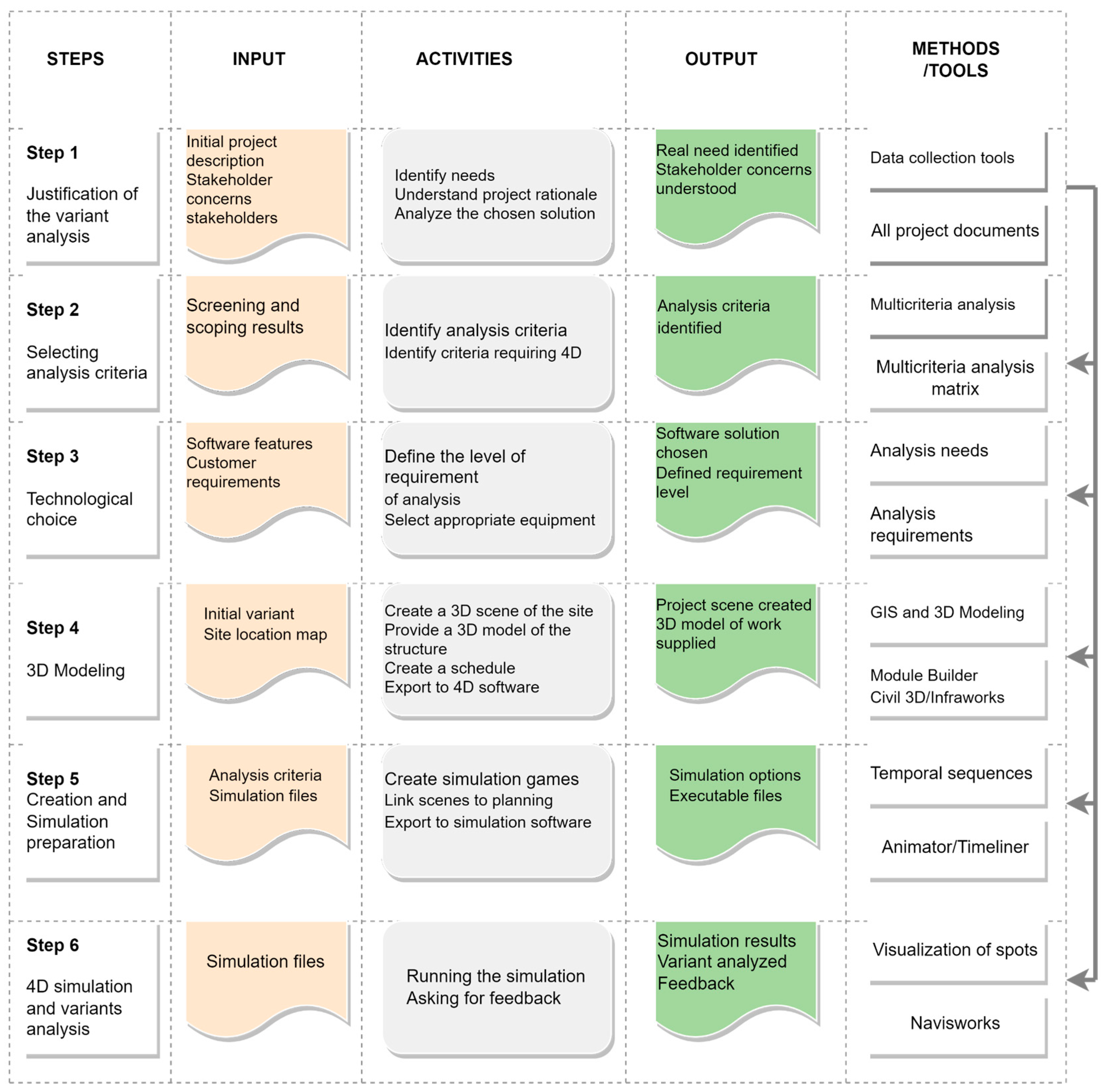
This stage consists of developing a conceptual framework for the deployment of BIM 4D that can help resolve the issues raised in the previous stage. The process of developing the conceptual framework followed six stages. The first two stages of the framework highlight the technological, economic, and socio-environmental factors that will justify and determine the scope of the analysis of project variants. Stages 3 and 4 define the level of requirements of the analysis, which will condition the technological choices, and then model the structure and the project site in 3D. Finally, stages 5 and 6 prepare the simulation scenes and the conduct of the simulation, which will lead to feedback.
3.2. Elaboration of the Proof of Concept
We have developed and tested the various stages of the conceptual framework for using 4D to support the variant analysis process listed in the previous section through a case study of a road improvement project in western Quebec. The aim of this proof of concept is to carry out an evaluation of the various variants of the proposed framework and to draw lessons learned from them. During this stage, the variant analysis workflows based on construction simulation are tested using the proposed tools and methods. The evaluation of the test results will be based on the following criteria:
The maximum number of environmental performance indicators that can be supported by BIM 4D;
The level of customer requirements for 4D simulation;
The level of understanding of spatio-temporal indicators (scenario intelligibility);
Navigation and interaction with 3D models of the structure and sensitive site elements in the virtual 4D environment by all users;
The possibility of generalizing the approach.
4. A Conceptual Framework for 4D Simulation-Based Variant Analysis in EIA
The proposed conceptual framework is a standard work process consisting of six complementary stages (
Figure 1): (1) justification for variant analysis; (2) selection of analysis criteria requiring 4D; (3) technology selection; (4) 3D modeling of the structure and project site; (5) preparation for 4D simulation; and (6) simulation conduct and feedback. Before giving some details of each stage of the framework, it should be noted that the method requires different types of input data. Geographical data on the current state of the site, design data, and data relating to construction activity can be found in tender documents.
The following sections provide more details on each of these steps.
4.1. Step 1: Rationale for Variant Analysis
The aim of the first step is to provide the rationale for the analysis of alternatives to a selected project solution, i.e., to identify the project components with severe impacts and the sensitive receptor components that require an analysis of alternatives. This stage begins by gathering information on the project. This information can generally be found in the project notice, which is the initial description (variant 0) of the project. The aim is to analyze the initial project description and the various possible variants for carrying out the project, and to see whether the latter are compatible with the projected objectives and can consider the concerns of stakeholders. To ensure a successful variant analysis, it is necessary to identify the promoter’s requirements from the outset, highlight those elements of the project likely to generate significant impacts on the receiving environment and on the public, analyze the choice made of the alternative (solution selected), and see whether the latter meets the promoter’s needs and, above all, the projected objectives.
The need for a variant analysis is determined by the project category. If the project is in category A (Severe Impact Project) according to World Bank standards, it is mandatory to carry out a variant analysis during the design phase to bring together all stakeholders. Variant analysis goes beyond the analysis of the project site options. It encompasses site analysis, constructability analysis, project schedule planning options analysis, and even technology selection. Variant analysis of a construction project is based on several criteria, generally defined by the national authorities of the country in question.
4.2. Step 2: Choice of Variant Analysis Criteria
Having identified the elements of the project likely to generate severe impacts on the sensitive elements of the receiving environment and the public, the identification of criteria for the analysis of variants is an important step, as they will serve as a useful basis for the rest of the process. It should be noted that the environmental analysis factors for a designated project are defined and delimited by the national agency in charge of environmental assessment. It is the agency’s responsibility to define practical and optimal criteria based on the needs of the proponent, projected objectives, stakeholder concerns, and regulatory and legislative requirements. Traditionally, the determination of environmental analysis criteria is based on screening results. These criteria are generally divided according to the project’s technical, environmental, and socio-economic aspects, but in some cases, they must take into account changes in the country’s regulations and legislation.
When using 4D BIM applications to support variant analysis, only those indicators requiring 4D will be supported. To ensure a comprehensive selection of environmental and social optimization indicators for a project variant, we propose a scenario that covers all phases of the project (from identification of the feasibility of the need to the operation of the structure). The aim of such a scenario is to detect possible conflicts and impacts during the design, construction, and operation phases. Depending on the scenario defined, an appropriate choice of technological tools is essential for carrying out an optimal analysis.
4.3. Step 3: Technological Choices
The choice of technological tools depends on the possible project scenarios, the developer’s visualization needs, and the level of requirements for all parties. Once geographic data on the current state of the site, design data, and data relating to construction activity have been acquired, it is essential to make the right technological choices to best represent the various workflows involved in planning construction and its impacts on the public and the environment.
When using 4D simulation to support the variant analysis process, the choice of technological tools can be divided into three parts:
The first part concerns the tools used to model or generate the site in 3D. There are a multitude of tools available, but their choice should be based on the following criteria: interoperability and level of requirements (intelligibility of the real 3D context and level of detail of the issues present on the site). Tools such as ArcGIS Pro 3.1, the of Infraworks 2024 Model Builder, etc. are available.
The second is the choice of 3D modeling software. The criteria of collaboration, interoperability, and the level of detail of the various elements of the structure should guide this choice. At this stage, it is important to create specific sequences of project activities, combining them with a new or modified schedule.
The last part consists of choosing 4D simulation software for coordinating 3D models (site + facility + schedule) to proceed with the analysis.
A good technological choice will guarantee the success of the process and allow better renderings or 3D views to be obtained for analysis.
4.4. Step 4: 3D Modeling
Modeling the structure and its site is a crucial stage in the process, as it is at this level that the various trades involved in the project must express their requirements in terms of views, rendering quality, and design details to facilitate later detection of conflicts and better analysis of possible variants. 3D modeling begins with the creation of the actual site context in 3D (the various traffic networks surrounding the project and the sensitive elements surrounding the project right-of-way), followed by the representation of the structure of the work (road, bridge, tunnel, railroad, etc.) that is to be constructed.
In the proposed standard workflow, it is desirable for the planned structure model to be generated concurrently with the creation of the actual 3D context to facilitate the import of topographic points and site surfaces into 3D modeling software. With the integration of Geographic Information Systems (GIS) and Building Information Modeling (BIM) for land development, tools such as ArcGIS Pro and the Infraworks Model Builder module can be employed to create the realistic 3D context of the project site. Subsequently, depending on the visualization requirements and the type of impact modeling, modelers can choose specific visualization techniques for each impact to be visualized. We propose two impact visualization techniques based on 3D and 4D models, which are described in the following section.
4.5. Step 5: Creation and Preparation of the 4D Simulation
Creating simulation models is an important step for the success of the rest of the process. Two techniques based on 4D CAD applications [
4] can be used to create visualization scenarios of the environmental impacts of a linear construction project. In the first technique, issues present in the project environment, such as buildings, associated roads, sub-watersheds, species habitats, and others, can be integrated into the project structure and its real 3D context (3D site). The next step is to set up color codes so that different construction activities and their impacts can be discerned. Already at this level, analyses can be carried out. The position of the structure’s right-of-way, the location of issues in the zone of influence, adjacent sites that could generate cumulative impacts, and the encroachment of sub-watersheds can all be analyzed at this stage using the virtual tour.
The second technique finally allows for the addition of a construction schedule, either created or modified, to project activities for analyzing the timing, location, and size of impact zones for specific tasks. This means that specific sequences (start date-end date), as well as objects and surfaces from the 3D model, can be prepared and transferred into 4D simulation software solutions. This technique enables the visualization of spatio-temporal impacts during the project’s lifecycle, such as the spread of noise or dust, the vibration of machinery during excavation, and encroachment on the habitats of vulnerable species, which can sometimes lead to the displacement of these species from their natural habitats.
For these models to be useful tools, they must meet a set of criteria and provide a certain expected level of interactivity, graphical representation, detailed planning, and dynamic interaction. This expected level varies according to the specific needs of users. Heesom and Mahdjoubi identified three basic applications for 4D models: product modeling and visualization, process modeling and analysis, and collaboration and communication [
32]. For each of these requirements, they have proposed the necessary levels of interactivity, graphical representation, planning details, and dynamic suitability (
Table 1).
Once the impact simulation scenes are created and ready for visualization, various stakeholders can come together in the 4D virtual environment to view different project sequences.
4.6. Step 6: Simulation and Feedback
The final step of the method aims to carry out the simulation phase and provide feedback. This is where various project execution variants are analyzed. To successfully complete this step, a good understanding of simulation needs for different parties or users, user interactions, and visualization tasks is required. Analyzing project variants based on 4D models aligns more with process modeling and analysis applications, collaboration, and communication applications.
The criteria for analyzing variants consist of design attributes, construction attributes, and environmental impact attributes. Design attributes refer to standardization factors (current standards, legislative and regulatory texts) and economic impact factors (component flexibility, resource availability, and workforce skills). Construction attributes include space factors (material access, personnel access, equipment access) and installation factors (construction sequence, weather effects, safety). Environmental impact attributes include public service availability factors (government facilities, road capacity) and site impact factors (adjacent sites, nearby infrastructure, species habitats, pollution, etc.).
The simulation will consider the interactions of different users with multiple views in the virtual environment and the level of understanding of each party. Several navigation options can be used during the simulation to enhance understanding. The 4D visualization of various project activity sequences will help understand the project’s impacts throughout its lifecycle and propose mitigation measures that can align the interests of all parties involved.
5. Proof of Concept: A Case Study of a Road Project in North-West Quebec
The proof of concept, developed as part of this research project, serves as an evaluation tool for the various stages of the proposed framework. It represents a reiteration of the process for analyzing project variants of a road project in Western Quebec. This variant analysis was conducted as part of an environmental impact study mandated by the Impact Assessment Agency of Canada on the project promoter (Quebec Ministry of Transportation).
The case study is based on a documentary review of the project, including the tender technical documents, the project’s environmental impact assessment report, public consultation reports, and monthly reports on the project’s progress from the start of construction. To test and evaluate the two techniques for simulating environmental construction impacts, we propose two scenarios based on a 3D and 4D model, respectively. The following sections present the results of testing the various stages of the proposed framework.
5.1. Justification for Variant Analysis
The purpose of justifying variant analysis is to understand the real project needs, identify the project’s reasons for existence, and have a rough idea of the various possible project execution variants. The road project used in this case study crosses a region characterized by geological formations and specific environmental conditions. From an environmental perspective, the area served by the road is home to diverse wildlife, including deer, moose, black bears, and a multitude of bird species. The lakes and rivers scattered throughout the region are often used for fishing and boating. The project encompasses interventions along approximately 200 km. The project involves a major refurbishment of an existing section of the road and the creation of new routes (covering approximately 86 km). The project’s objective is to enhance the safety and traffic flow of the road, promote connectivity in the region, and improve access to the natural resources in this region.
The project’s necessity is justified by several factors, including road safety concerns, the growth of mining and recreational tourism activities, as well as the desires of the municipal and community sectors.
After analyzing various project documents, the primary pieces of information justifying variant analysis are summarized in
Table 2.
It should be noted that all this information stems from the preliminary project review and the initial public consultation. Based on this information, the factors for the environmental analysis of the project will be defined and delineated by the AEIC (Agency for Environmental Impact Assessment).
5.2. Selection of Analysis Criteria
The analysis and selection of analysis criteria, requiring a spatio-temporal visualization, determine the next steps in the process. In the current project under study, the AEIC has defined and delineated several environmental analysis criteria upon which the analysis of different project implementation variants must be based (
Table 3). The delineation of these criteria is based on the screening results, the initial project description, and the initial results of the public consultation.
After delineating the environmental analysis factors based on the screening results and the initial project description by the AEIC, an integrated project management group conducted a multi-criteria analysis of the project’s environmental and social performance. Based on these analysis criteria, we proceeded to select criteria deemed important and requiring spatio-temporal visualization. Using the results of the work carried out by the integrated project management group, we developed two visualization scenarios based on criteria that require 3D and 4D visualization models to understand and assess severe impacts:
The first scenario already allows for a virtual site tour within the 3D model, providing a panoramic view of various aspects, including the locations of various environmental considerations, adjacent sites that may generate cumulative impacts, etc. At this level, several environmental performance indicators related to site management can be accommodated.
The second scenario involves the use of 4D visualization techniques to assess the impacts of various project activities on the environment. The goal of this scenario is to understand the evolution of the impacts from various construction activities and their potential negative effects on different functions within residential, natural, and industrial zones, or local and regional road networks. Some examples of spatio-temporal indicators that can be considered are presented in
Table 4.
In the proof of concept, we tested the first scenario based on 3D models, and for the second scenario, we chose to visualize the impact of noise during the road’s operational phase on the residential environment. The implementation of these two scenarios requires the selection of suitable technological tools, which will be presented in the next step.
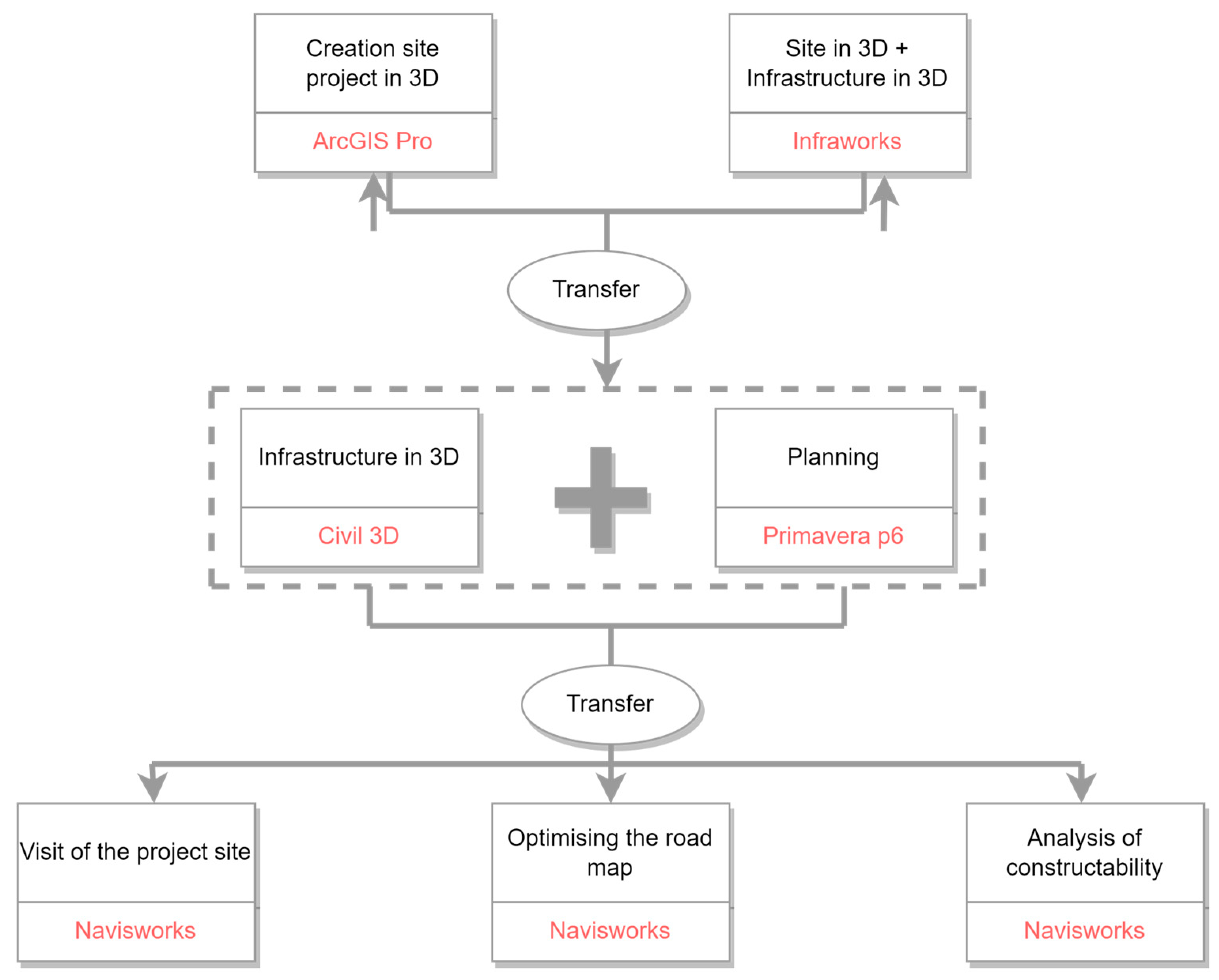
5.3. Technological Choices
The development of a 3D project scene that incorporates an infrastructure, such as a road, for environmental analysis requires suitable tools to effectively present various elements of the real project context.
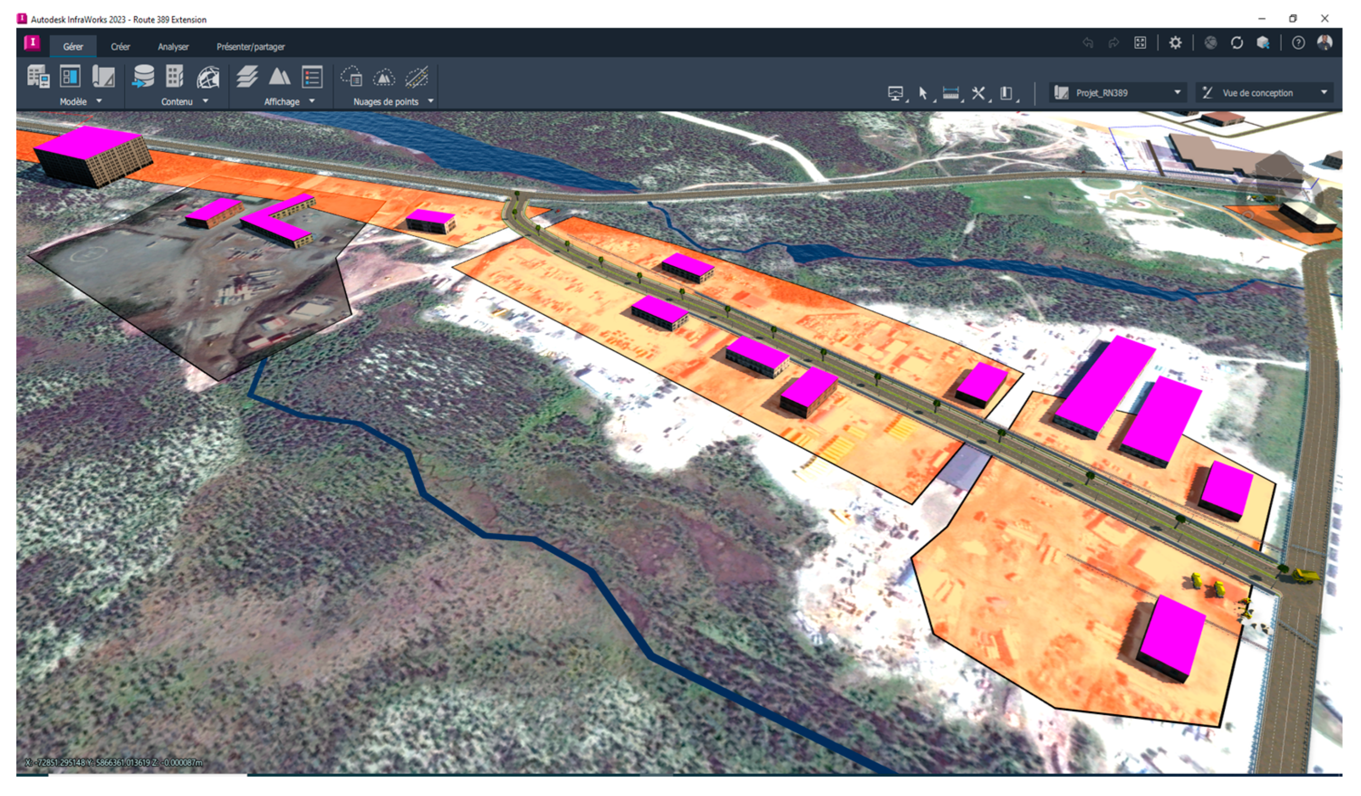
Figure 2 illustrates a scenario for selecting technological tools to model and coordinate the flows of environmental and social optimization work for the alignment of a road.
Based on the scenario described, the software tools corresponding to the needs were chosen to model the various scenarios outlined in the previous step. In this work, the selection of these software tools is based not only on the availability of their licenses at our laboratory but also on the level of graphical representation of the real project context. For example, in this project, the choice of the Infraworks Model Builder to create the 3D real context of the project is linked to the quality of the environment rendered. The choice of Navisworks to coordinate the various files and simulate the project is simply based on the availability of an educational license.
5.4. 3D Modeling
In the proposed working method, modeling is the process of creating virtual three-dimensional objects in a digital environment. The purpose of this process in the developed approach is to encourage collaboration efforts among different professional disciplines involved in the Environmental Impact Assessment (EIA) process to have a common analysis and communication platform. The modeling process begins with an effort to identify technical input data, which are generally categorized into three groups:
Geographic data about the current state of the area: These can be obtained from Geographic Information Systems (GIS) or existing design documents. Important geographic data include site topography or information about the surrounding built environment.
Design data for the structure: These typically include information about the new structure’s layout, its exact geometric properties, and its structural composition. This information can be obtained from the project’s design documentation, for example, from the project’s initial description in tender documents.
Construction activity-related data: These should include information about the project’s phasing and a construction schedule covering the entire life cycle of the modeled structure. Information about the potential impact of different construction methods on the public and the spatial extent of these impacts is also particularly important input data for the proposed modeling process.
After collecting these data and, if necessary, converting them for use with specific 3D modeling software, the modeling process can take place. The modeling of the two defined scenarios follows these steps:
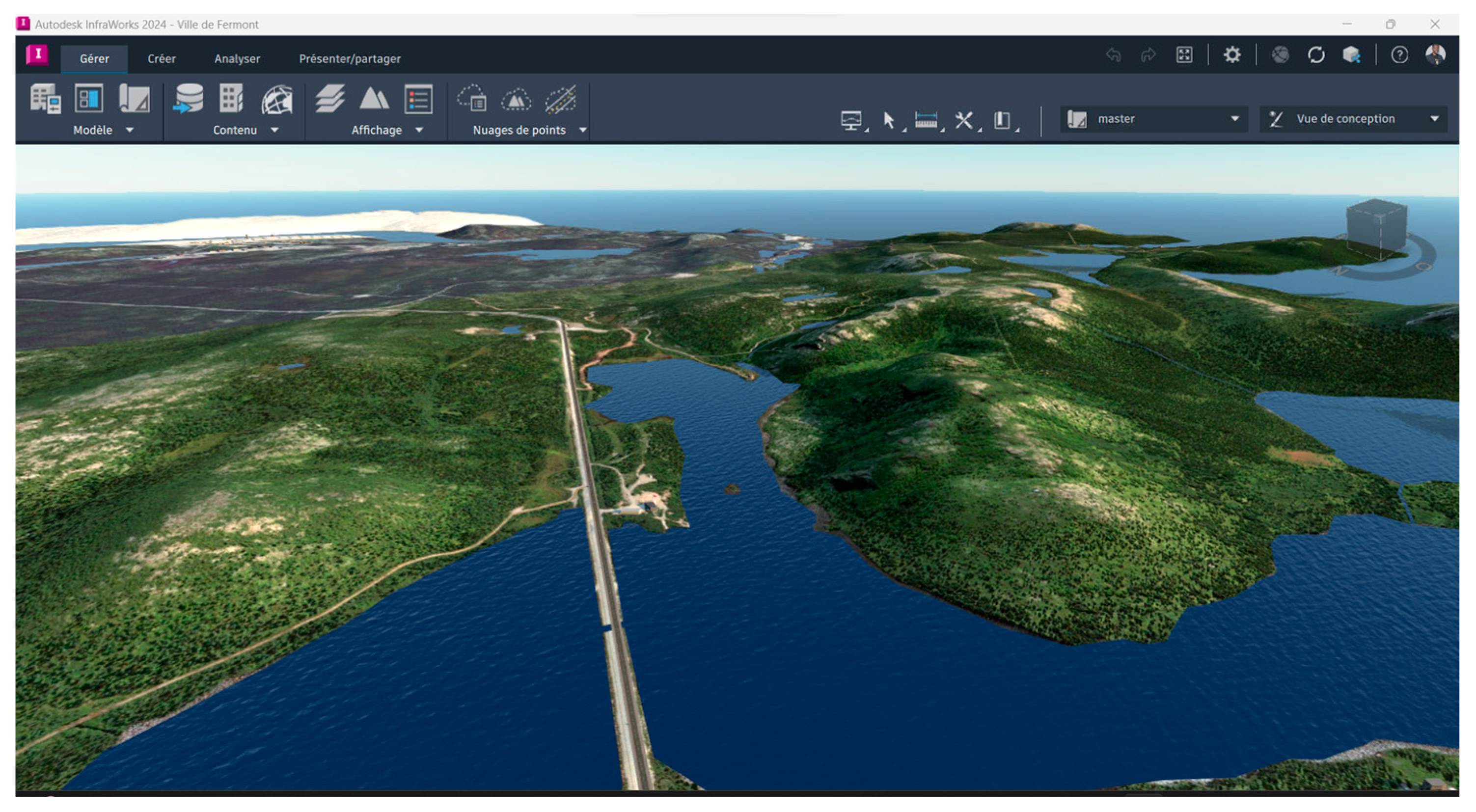
Generating the site location map: This can be carried out using mapping software such as QGIS, ArcGIS Pro, or others. In the context of our work, the location map for different sections of the road was provided by the promoter.
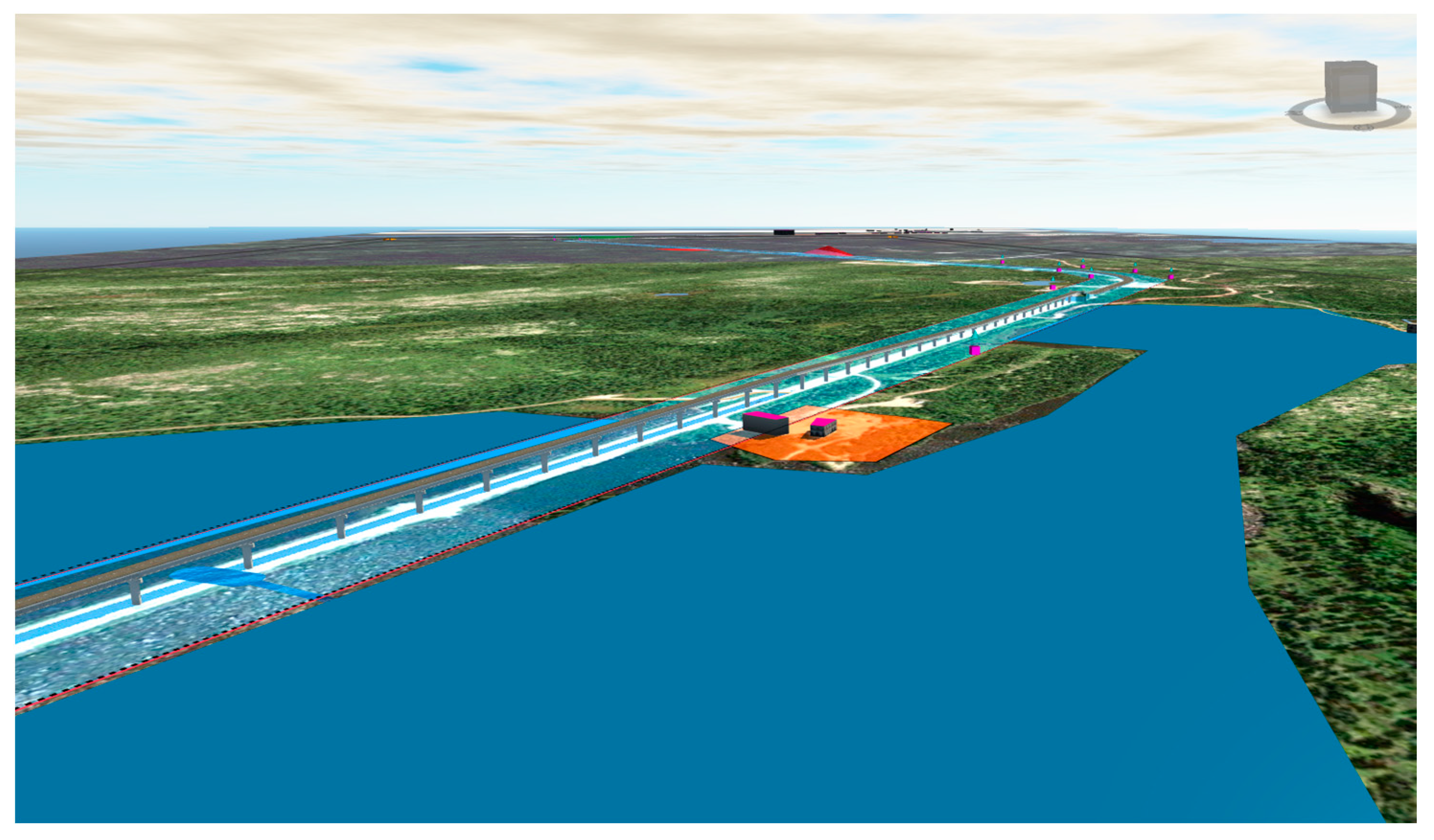
The creation of the real 3D context of the project site was carried out using the Infraworks Model Builder (
Figure 3).
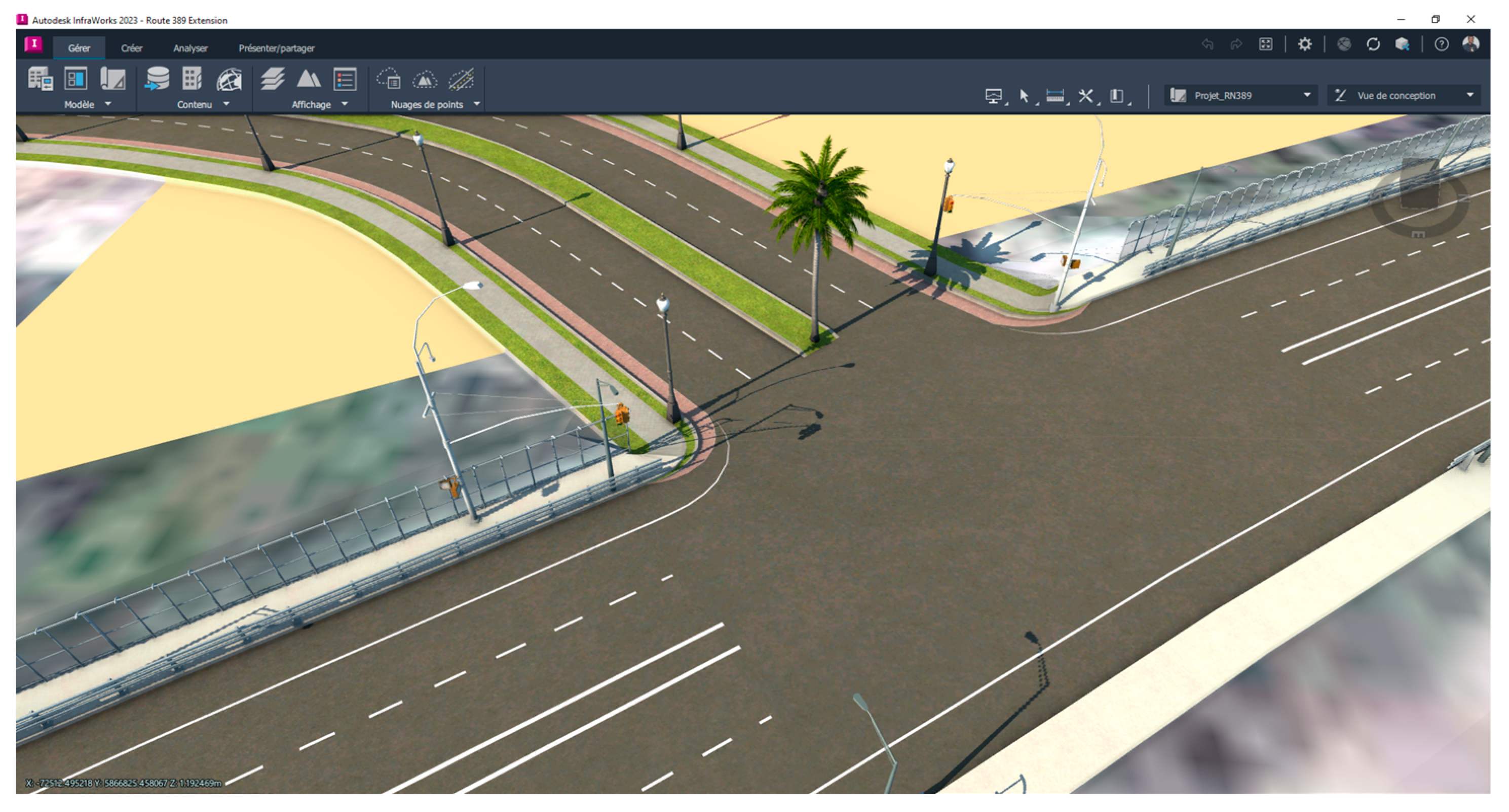
The modeling of the road in Civil 3D 2024 and then in Infraworks 2024: The use of Civil 3D 2024 in this project allowed for the extraction of contour lines for the road’s footprint and, most importantly, the verification of slope and camber. The modeling of project elements in Infraworks 2024 allows for the depiction of road segments in a more realistic 3D view (
Figure 4).
The creation of the project schedule using Oracle Primavera P6: Creating a schedule with specific project activity sequences is necessary for planning the various phases of the project in Navisworks Manage 2024. It is important to ensure that these models are saved in transferable formats. The next step will involve transferring all the files into the coordination software (in this case, Navisworks Manage) to create sequences for visualizing potential impacts.
5.5. Creation and Preparation of the 4D Simulation
It is during this step that the two impact visualization scenarios are modeled. Referring to the key construction attributes, the variant analysis will be based on the following factors: construction sequence, access to materials, access to equipment, and the site’s impact on adjacent sites. As we have seen in previous sections, the use of construction simulation models to support variant analysis falls within the applications of process modeling and analysis, collaboration, and communication. Therefore, a high level of interactivity is required for 4D simulation, for visualization details, and for the comprehensibility of the simulation (
Table 5).
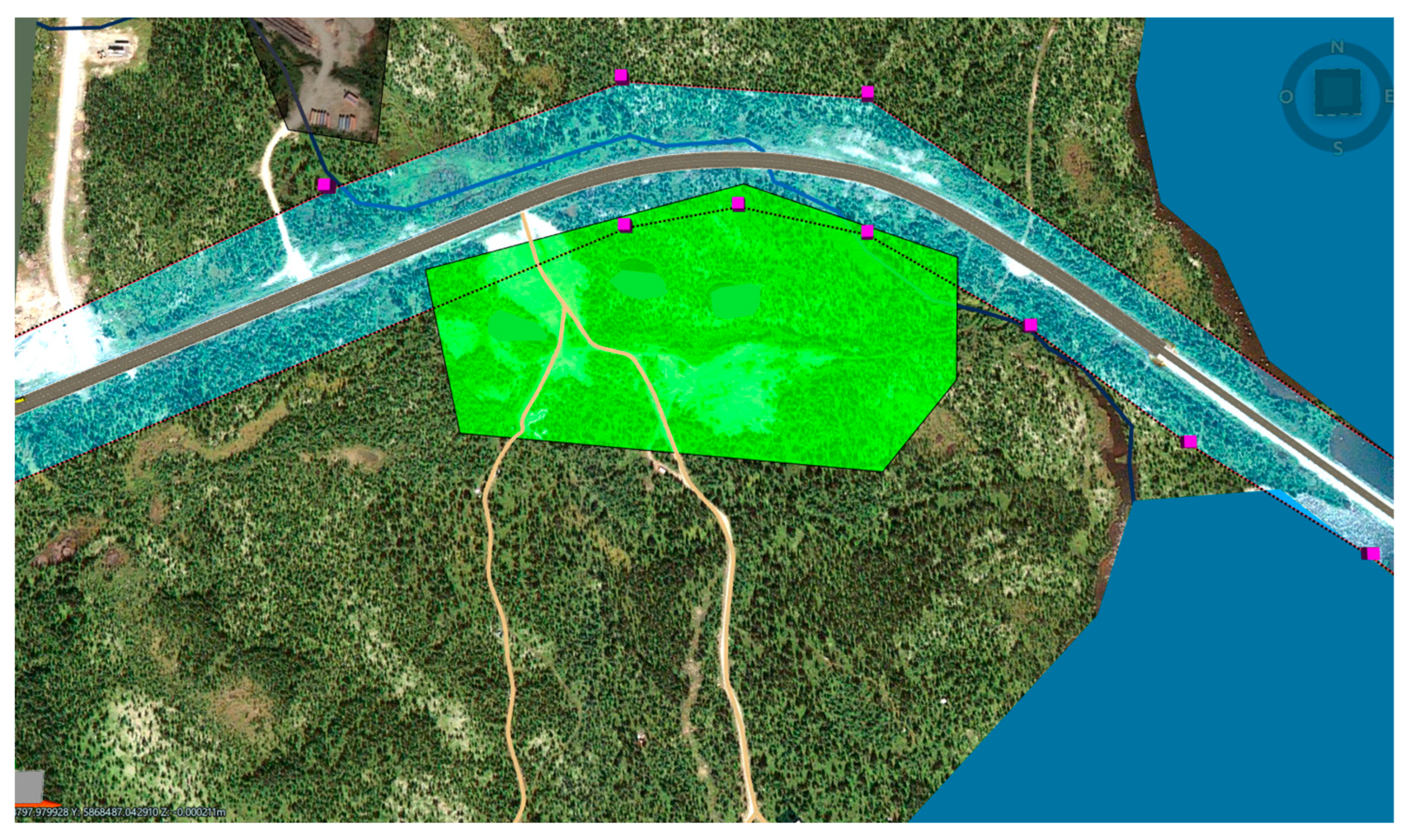
It is based on these requirements that the two impact visualization scenarios, based respectively on 3D and 4D models, will be created. The 3D scenario is created by configuring color codes to distinguish different construction activities and their impacts. Various viewpoints (geotags) of the integration of project elements into different environments (residential, natural, aquatic) enable a virtual site tour. The creation of 3D visualization models can be entirely carried out in software such as Infraworks, which is a powerful site analysis tool. The virtual site tour can allow for an understanding of the layout or location of environmental concerns in relation to the road footprint, including encroachment on wildlife habitat (
Figure 5), encroachment on private property (
Figure 6), or dust in the residential environment (
Figure 7).
The creation of different spatio-temporal visualization sequences for the chosen criterion (noise impact on the residential environment) is carried out using the Timeliner tool in Navisworks. The schedule created earlier is imported into Timeliner, and specific project tasks are assigned to the temporal sequences for analysis. Once the two impact visualization scenarios are created, we can proceed to the final step of the process, which involves conducting the simulation.
5.6. Simulation and Feedback
The final step of the test aims to conduct the simulation phase and provide feedback. The simulation starts with a virtual site tour of the project site to observe and analyze the location of various issues about the road footprint. The project site tour can be conducted through geotags (view captures) or navigation tools (zoom) from Infraworks to understand the possible interactions between the project site and the surrounding environment. The Animator tool in Navisworks can also be used to animate different pre-recorded viewpoints for a panoramic view of the project’s integration into its real environment.
During this virtual tour, analyses related to site-related criteria can be performed. For example, the length of the road crossing a lake, the area of sub-basins encroached by the road footprint, the distance between the project’s main site and borrow sites, the distance between industrial sites and the project site that could cause cumulative impacts, etc., are criteria that we were able to verify with the 3D model.
Adding the project schedule to specific project sequences in the Timeliner tool allowed us to see the extent, timing, and spatial location of future noise impacts from construction equipment on the residential environment. This is referred to as a 4D visualization or simulation.
The impact of noise on the residential environment during road operation is analyzed using the 4D model created in the Timeliner module of Navisworks Manage 2024.
The environmental analysis of different project phases is mainly focused on:
the analysis of the project site (factors affecting the integration of the road into its host environment);
the analysis of different project components (roads + bridges);
the interactions between all activities on the project site and those of adjacent sites;
the quality of the communication medium for social acceptability.
In this proof of concept, the simulation experience is based on 3D models since most of the criteria are related to site management, and thus, there is a reliance on realistic 3D visualization of various issues at the site for analysis. It is important to note that in the development of this proof of concept, the exercise was largely based on understanding and analyzing impacts. Therefore, the proposal of mitigation measures, which is not addressed here in this virtual project, must be carried out within the framework of a more comprehensive environmental impact study of a real project. The test results are presented in
Table 6.
The developed proof of concept allowed us to verify the first scenario, which is the analysis of environmental performance criteria based on 3D models.
For the second scenario, we integrated the schedule with various construction tasks for a section of the road (roadway construction, installation of safety barriers, road landscaping, and installation of streetlights). The purpose of this scenario is to verify the evolution of dust or noise impacts caused by construction equipment in a residential environment. We can observe the progress of work in relation to the project schedule. We also simulated the movement of equipment in the completed section. However, the progress of road construction did not follow the normal stages of road construction because the designed models do not allow for the simulation of the successive stages of road construction. Therefore, the second scenario was not successful and will be the subject of future work.
6. Discussion
This research project primarily aims to analyze a methodological approach for the use of 4D BIM to support the variant analysis process of a road project within the framework of EIA. The developed concept considers road projects as integral parts of the zones in which they are built. In doing so, it represents an interesting attempt to develop a modeling method that enables dynamic visualization of the possible impacts of road construction works on their receiving environment. Currently, the majority of research on the use of BIM applications to support the environmental analysis process focuses on vertical building construction rather than horizontal linear construction works such as road projects [
33]. Therefore, this study is one of the few works that focuses on the development of a concept for using 4D BIM to better plan the construction impacts of horizontal structures. This research complements the broader body of work exploring the use of 4D visualization techniques to support environmental planning and management in the construction industry [
14].
The main lessons drawn from the results of the proof of concept and the analysis of the BIM adoption for supporting environmental analysis can be summarized as follows: The 3D impact visualization scenario helps us understand where specific types of impacts occur and how this, along with the severity of impacts, changes depending on the environment they traverse. The 3D scenario requires us to use the project’s longitudinal profile and mark areas sensitive to certain types of impact on these drawings. What is missing is the ability to visualize changes over time. The 3D scenario lacks the ability to provide a comprehensive overview, as we need to assess drawings and the project schedule separately, resulting in the loss of valuable information. By integrating design and scheduling work into a single model (4D scenario), we can verify if the proposed design and schedule are suitable concerning their impact on the project’s environment. For instance, closing certain lanes for work may take place during the weekends to avoid disrupting the flow of trucks from industrial sites.
In this experiment, even though the 4D simulation did not cover all phases of the project life cycle, the models can offer a dynamic insight into how impacts change as the project schedule changes. This insight could give us an advantage in competition to gain points for this aspect in the tender process. It could also help us make decisions regarding the best way to address different types of impacts based on the environment, timing, and magnitude. Visualizing the project’s impact in this way allows us to assess how and when different impacts occur by adjusting the schedule or limiting simultaneous work in certain areas. These 3D and 4D models are advantageous compared to 2D methods because they are easier for non-experts to understand than traditional technical drawings. These models are also useful tools for communication in the public consultation process.
Furthermore, the method provides a stepping stone for a better understanding of how to meaningfully visualize the impacts of project components on sensitive elements of the surrounding environment in space and time. With the advent of BIM methods in the construction industry that combine different information with geometric design models of facilities, visualization methods for non-geometric information will become increasingly important [
4]. Our study contributes to this discussion by providing a conceptual framework for the deployment of 4D BIM to meaningfully visualize information stored in multidimensional data models, which is applicable to visualizing the impacts of road projects.
In addition to these broader contributions to impact modeling theory, the developed method formalizes the use of two impact visualization techniques:
The use of color-coded surfaces in 3D models to indicate the location and extent of various types of impacts allows practitioners to grasp the spatial extent of possible impacts. Additionally, the use of 3D objects representing other structures or nearby roads related to the projected road will provide a more detailed picture of where the impacts will occur.
The second technique involves adding a project schedule to these models to visualize the evolution of these impacts throughout the project’s lifecycle.
By developing and testing the method, we provide evidence that the method and the two visualization techniques effectively provide planning professionals with a better understanding of the extent, magnitude, timing, and ways areas surrounding the project could be affected by the planned construction activity. The modeling method offers the opportunity to develop numerous project scenarios (variants) within a single 3D model and examine changes in project impacts without the need to create additional drawings or schedules. In this way, the modeling method provides practitioners with a way to reduce the time spent on creating drawings, schedules, and other related planning materials, thereby allowing more time for evaluating project scenarios and alternatives. Overall, we expect the method to have the potential to enhance the quality of decision-making when choosing variants for a road project to define construction strategies that minimize the impact of construction work on the host environment. More specifically, a 4D simulation provides the ability to simplify the visualization and the comparison of variant details. Some of these details can be difficult to explain to those unfamiliar with the field. 4D simulation, however, makes the process transparent and comprehensible to a wide range of stakeholders, whether construction experts or not. By bringing all stakeholders together around a clear, detailed visualization of the project alternatives, 4D simulation facilitates communication and mutual understanding. This enables the project team to collaborate more effectively, make informed decisions, and anticipate potential problems.
This study has some inevitable limitations. First, the validation process of the proposed method focused only on developing a proof of concept in the laboratory, thus the absence of real project stakeholders involved in the planning process. Naturalistic evaluations, conducted in a real environment with real devices, are more realistic in capturing all the complexities of the human experience in real organizations. Artificial evaluations are less realistic because they use laboratory experiments, simulations, field experiments, theoretical arguments, or mathematical evidence. A more in-depth study of a real case would allow for a more comprehensive comparison with the results of the traditional approach. Second, although the developed approach has major advantages in improving the environmental analysis process, it has limitations in terms of handling certain indicators. For example, social and legal indicators (social acceptability, land acquisition) are not supported by the construction simulation. Finally, the case study methodology used to conduct this research has limitations in terms of generalizing the results.
Regarding the results of the validation test of the proposed method, the work provided has limitations in terms of verifying the 4D scenario. We were unable to complete the modeling of the 4D scenario due to the time required to familiarize ourselves with the 4D CAD tools.
7. Conclusions
Analyzing variants in a road project within the framework of the Environmental Impact Assessment (EIA) is an important element of environmental planning and management. Finding a project schedule that minimizes impacts on the receiving environment is a multicriteria decision-making problem that requires trade-offs between potential impacts and their spatial and temporal extent. Furthermore, road projects are linear projects along which the characteristics or functions of the environment change. Consequently, the effect that different types of impacts have on the surrounding environment also changes. Understanding these impacts and planning for them in a project schedule is a complex and knowledge-intensive task.
We have developed a conceptual framework for the use of 4D simulation to help planners acquire an understanding of the temporal and spatial extents of impacts required in scheduling tasks. The approach uses two specific modeling techniques. The first technique is based on a 3D scenario that uses color-coded surfaces in 3D models to visualize the area affected by a particular impact and the use of 3D objects representing other structures near the projected road. The second technique allows for the addition of a project schedule to these models to visualize the evolution of these impacts throughout the project’s lifecycle. By applying color coding to surfaces and 3D objects, the method can also visualize different types of impacts and their magnitudes.
We tested the method by developing a proof-of-concept based on a case study of a road improvement project in northwestern Quebec. The lessons learned show that the method is capable of effectively visualizing the impacts of road projects and providing insights into these impacts. Despite these initial successful applications of the method, there are also some limitations in the method that offer opportunities for improvement. Firstly, currently, the generated 3D models cannot display a number of impacts. Adding too many impact visualizations quickly clutters 3D models to the point of becoming incomprehensible. Therefore, future research should design techniques for sequentially visualizing multiple types of impact within a single model without compromising its intelligibility or clarity of representation. The models currently created cannot statistically simulate impact visualization models and present an opportunity for future research to create more dynamic models using simulation tools. In this version of the work, data exchange between different stages of the framework is carried out manually. Future efforts will be dedicated to developing automation mechanisms to streamline user tasks. The aim of the work is to provide a neutral framework, even though the proof of concept was carried out using specific software.
In conclusion of this work, the conceptual framework of 4D deployment described provides practitioners with an effective alternative to current 2D methods that are relatively easy to use and understand. Furthermore, the proposed method is well-suited for evaluating different planning alternatives, as the initially created simulation models are easily adjustable. We believe and have illustratively shown that the method already has the potential to offer road construction planners a clear picture of the impacts of construction work on the environment and allows for the minimization of these impacts.


