Article

Remote Sensing Classification of Temperate Grassland in Eurasia Based on Normalized Difference Vegetation Index (NDVI) Time-Series Data

1
College of Resources and Environment, University of Chinese Academy of Sciences, Beijing 100049, China
2
Beijing Yanshan Earth Critical Zone National Research Station, University of Chinese Academy of Sciences, Beijing 101408, China
3
Beijing Geoway Software Co., Ltd., Beijing 100049, China
*
Author to whom correspondence should be addressed.
Sustainability 2023, 15(20), 14973; https://doi.org/10.3390/su152014973
Submission received: 5 September 2023 / Revised: 15 October 2023 / Accepted: 16 October 2023 / Published: 17 October 2023
(This article belongs to the Special Issue Remote Sensing Monitoring of Resources and Ecological Environment)

Abstract

:
The Eurasian temperate grassland is the largest temperate grassland ecosystem and vegetation transition zone globally. The spatiotemporal distribution and changes of grassland types are vital for grassland monitoring and management. However, there is currently a lack of a unified classification method and standard distribution map of Eurasian temperate grassland types. The Normalized Difference Vegetation Index (NDVI) from remote sensing data is commonly used in grassland monitoring. In this paper, the Accumulated Rate of NDVI Change Index (ARNCI) was proposed to characterize the annual NDVI trend of different temperate grassland types, and four transitional categories were introduced to account for the overlap between them. Based on survey data on the distribution of Eurasian temperate grassland types in the 1980s, the study area was divided into three sub-regions: Northern China, Central Asia, and Mongolia. Regionally, pixel-based ARNCI maps in the 1980s and 1990s were successfully calculated from using NOAA’s AVHRR NDVI time-series products. The ARNCI classification thresholds for different sub-regions were determined, and classification experiments and validation were conducted for each sub-region. The overall accuracies of grasslands types classification for Northern China, Central Asia, and Mongolia in the 1980s were 75.3%, 64.2%, and 84.6%, respectively, which demonstrated that there were variations in classification accuracy in the three sub-regions, and the overall performance was favorable. Finally, distribution maps of Eurasian temperate grassland types in the 1980s and 1990s were obtained, and the spatiotemporal changes of grassland types were analyzed and discussed. The ARNCI method is simple to operate and easy to obtain data, and it can be conveniently used in grassland type classification. The maps firstly address the lack of remote sensing classification maps of Eurasian temperate grassland types, and provide a promising tool for monitoring grassland degradation, management, and utilization.

1. Introduction

As the largest terrestrial ecosystem on earth, grassland plays a crucial role in regulating the climate, maintaining soil moisture, reducing soil erosion, and promoting ecological balance [1]. Based on composition and geographic distribution, global natural grasslands can be categorized into temperate, cold, warm-temperate, and tropical zones. Among them, temperate grasslands represent one of the vastest biomes on earth, with Eurasian grasslands occupying the largest grassland belt in the mid-latitudes of the northern hemisphere [2]. Temperate grasslands are indispensable for production, serve as important ecological barriers, and are critical for the development of grassland resources, conservation of grassland biodiversity, and sustainable ecosystem management. In recent years, due to immense pressures such as climate change and land use, temperate grasslands have become one of the most endangered ecosystems [3,4,5,6,7,8,9]. Changes in grassland types serve as important indicators for monitoring grassland degradation or improvement. Therefore, accurate knowledge of the spatiotemporal distribution of grassland types is vital for monitoring grassland quality.
Due to the influence of multiple factors such as climate, soil, and topography, the growth of grasslands varies significantly, resulting in substantial differences in grassland distribution. As a result, several scholars worldwide have proposed different classification systems for grasslands [10,11,12,13]. For example, in the early plant community classification system, Stoddart and Smith [10] divided grazing areas in the western United States into 9 grazing regions and 18 grazing types based on the characteristics of grassland plant communities and whether they were used for grazing purposes. In the land-phytocoenological classification system, Salisbury [11] categorized British grasslands into five types (neutral grassland, acidic grassland, alkaline grassland, etc.), based on soil and vegetation conditions. In the climate-phytocoenological classification system, Australian grasslands were divided into nine major categories, including wet tropical, arid tropical, arid temperate, subalpine, etc., based on climatic conditions, and further classified into grazing and artificial grassland types based on vegetation characteristics [12]. In the agricultural management classification system used in Western European countries, Watson and More [13] classified grasslands into three major categories, namely, semi-natural grassland, improved permanent grassland, and artificial grassland, based on the degree of human cultivation, and land and vegetation characteristics. Previous studies have shown that there are currently no universally accepted classification indicators or method for grassland types. Many studies qualitatively or quantitatively analyzed the relationships between vegetation types and some special indicators such as soil [14], climate [15], and vegetation distribution patterns [16]. Moreover, these classification systems are established based on local characteristics of geographic environments that cannot meet the global demands for grassland classification.
Remote sensing technology enables long-term and large-scale earth observations, making it an important tool for grassland remote sensing. Grassland remote sensing classification can be divided into two main directions. On the one hand, some research has focused on rough classification of grasslands at a large spatial scale, mostly at the land use level. For example, global land cover datasets classify grasslands into categories such as grassland, mixed grassland, etc. [17,18,19,20,21]. However, such studies often regard grassland as a single category or a mixed category, and differentiate it from other land cover types. Due to the limitations of spatial resolution in remote sensing imagery and the complex characteristics of grasslands, which are of low height and diverse vegetation structures, as well as mixed growth, these methods are often unable to distinguish between grassland types. On the other hand, there is research focus on fine classification of grasslands in specific local areas, using UAVs and high-resolution satellite and airborne data to classify fine-scale grassland types, species, and communities [22,23,24,25,26,27]. These classifications are limited by data availability and cost, and only commonly applied at small regional scales, making it challenging to extend to a global scale. Many scholars have conducted grassland classification studies in specific local areas. For example, Wen [28] used MODIS time-series data to classify grasslands in Tibet, China, into six types, including meadow grassland, typical grassland, desert grassland, alpine meadow grassland, alpine typical grassland, and shrub herbaceous grassland, achieving an overall accuracy (OA) of 68.02%. Qiao et al. [29] employed decision tree to classify eight grassland types, including temperate meadow grassland, temperate grassland, alpine meadow, lowland meadow, and marsh, in the Ili of Xinjiang, China, with a classification accuracy of 85%. Zhou et al. [30] used expert knowledge-based decision tree to classify grasslands on the northern slope of the Tianshan Mountains in Xinjiang, China, into five types, including plain desert, plain desertified land, low mountain desertified land, temperate meadow, and alpine meadow, with an overall accuracy of over 95%. It is worth noting that these grassland classification studies were conducted on small scales, and the classification systems and criteria are not generalized. Currently, there is no research on the classification of temperate grassland types at the Eurasian scale. This study aims to explore a generalized classification method and system suitable for the Eurasian grassland.
The Normalized Difference Vegetation Index (NDVI) product from remote sensing data is commonly applied in vegetation monitoring studies [31,32]. However, using NDVI as a single feature for fine-scale grassland classification has limitations [33]. It is often combined with other variables such as topography, climate, and environmental factors [34,35]. In this study, based on ground survey data in the research area, the monthly variation characteristics of NDVI for different types were analyzed. This study proposes the Accumulated Rate of NDVI Change Index (ARNCI) for temperate grassland classification and extends this method in space and time at the Eurasian scale, which may also provide reference for the large-scale distribution research of other grassland types. This research generated temperate grassland type maps in the Eurasian continent over the past 40 years, and conducted dynamic change analysis. The maps firstly address the lack of remote sensing classification maps of Eurasian temperate grassland types, and provide a promising tool for monitoring grassland degradation, management, and utilization. The scientific questions mainly addressed are as follows: (i) Is there a uniform method to classify temperate grassland at the Eurasian scale? (ii) What are the distribution and transition patterns of grassland types in different ages and regions?

2. Materials and Methods
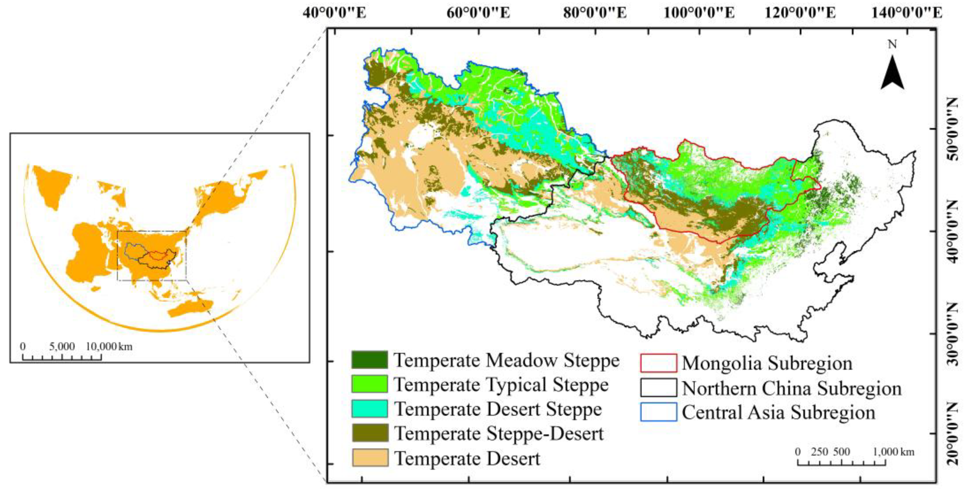
2.1. Study Area

The study area is the main part of the Eurasian temperate grassland (Figure 1), with longitude and latitude ranging from 46°29′ to 135°5′ E and from 3°50′ to 55°27′ N, respectively. The Eurasian grassland stretches approximately 8000 km [36], covering about 150 million hectares and spanning 110 longitudinal zones. It encompasses vast vegetation types such as temperate grasslands, sparse woodlands, and shrublands, making it the largest temperate grassland ecosystem and vegetation transition zone globally [37]. It can be roughly divided into three sub-regions: the Black Sea–Kazakhstan steppe, the Mongolian Plateau steppe, and the Qinghai–Tibetan Plateau steppe [38]. This study collected some ground truth data, including vegetation type maps of five Central Asian countries in the 1980s, vegetation type maps of the People’s Republic of China in the 1980s, and grassland coverage data from Mongolia in 1990. The research area of the Eurasian temperate grassland was divided into three sub-regions, namely, Northern China, the five Central Asian countries (Kazakhstan, Kyrgyzstan, Uzbekistan, Turkmenistan, and Tajikistan), and Mongolia, by considering the differences in data sources, spatial resolution, mapping methods, and accuracy. For the Northern China temperate grassland range, this study extracted the provinces covered by grassland types referenced in the vegetation type map of the People’s Republic of China in the 1980s. The 15 provinces included in this study are Heilongjiang, Jilin, Liaoning, Beijing, Tianjin, Hebei, Shanxi, Inner Mongolia, Shaanxi, Gansu, Qinghai, Ningxia, Xinjiang, Shandong, and Henan. As these provinces are located in the northern part of China, they were merged and defined as the Northern China sub-region.

2.2. Data

2.2.1. Ground Truth Data

This research collected some ground truth data as prior knowledge for feature analysis and classification validation. As the study area includes different countries, it should be noted that the ground survey data were collected from different sources, and the mapping accuracies were inconsistent because they were produced using non-uniform methods by different countries. The collected data are showed in Table 1.
Vegetation type map of the five Central Asian countries in the 1980s, with a scale of 1:2,500,000. These data were digitized from paper maps of the former Soviet Union and supplemented with field measurements. They were provided by the Center for Regional Studies of the Chinese Academy of Sciences.
Vegetation type map of the People’s Republic of China in the 1980s [39]. These data primarily relied on field surveys and measurements of biomass, with remote sensing image verification as a secondary source. They included 1:500,000 grassland vegetation type maps, grassland classification maps, and grassland land-use status maps for each province. These were compiled into a national-level 1:1,000,000 map of vegetation types in China.
Grassland coverage data of Mongolia in 1990 [40], with a spatial resolution of 30 m. These data were derived from Landsat TM/ETM+ images and classified into 9 primary categories: forest, grassland, wetland, cropland, water, tundra, construction land, bare land, and snow. The classification accuracy was 82.26%. The data were obtained from the website of the International Knowledge Centre for Engineering Sciences and Technology (IKCEST) for Disaster Risk Reduction [41].
This article performed data extraction and merging based on the same vegetation types and subcategories of temperate grassland, since the vegetation type data contained multi-level categorical attributes. The temperate grassland types were classified into five categories: temperate meadow steppe, temperate typical steppe, temperate desert steppe, temperate steppe-desert, and temperate desert. To facilitate data analysis, the following steps were processed: spatial gridding, resampling to 1 km spatial resolution, projection transformation, and unification of geographic coordinates. The grassland type ranges from the three research sub-regions were integrated to obtain the survey map of temperate grassland types in Eurasia in the 1980s at a resolution of 1 km (the picture on the right of Figure 1). This map served as the data foundation for classification and validation.

2.2.2. Remote Sensing Data

The study used the NOAA CDR AVHRR product data: Normalized Difference Vegetation Index, Version 5 (NDVI) product data from the Google Earth Engine (GEE) platform. The data are available for direct download in netCDF format, with 0.05° × 0.05° spatial resolution and 1-day temporal resolution. The GEE cloud platform [42] consists of servers that can handle petabyte-scale data and perform high-performance parallel computing [43]. Using GEE, the monthly NDVI data from 1981 to 2000 were downloaded in batches. Preprocessing steps such as stitching, clipping, cloud removal, band calculations, map projection transformation to GCS-WGS84, and resampling were performed on the data. The data were then converted to the .tif format, resulting in NDVI monthly data with a spatial resolution of 1 km for the period between 1981 and 2000.

2.3. Grassland Classification System

As mentioned before, there are many different classification systems proposed by scholars worldwide, and these systems and criteria for classification are not consistent. To conduct a broad-scale classification and comparative study of grassland types, it is necessary to establish a unified classification system with standardized criteria. Jia [44] proposed a vegetation-habitat classification method that combines grassland characteristics with environmental factors such as climate, topography, and soil as the criteria. This method involves three hierarchical levels: class, group, and type. The first level, class, reflects the characteristics of major climate zones and mainly represents dominant vegetation types. There are 18 types, including woodland steppe, temperate meadow steppe, temperate steppe, temperate desert steppe, mountain steppe, alpine steppe, temperate desertified steppe, temperate desert, alpine desert, shrub steppe, hill steppe, montane sparse shrub meadow, continental meadow, mountain meadow, alpine meadow, swamp meadow, herbaceous swamp, and hummocky swamp. The second level is group, which serves as the basic unit for grassland management. The same groups have consistent meso-topographic, climatic, and substrate conditions. The third level is type, which represents the basic unit of classification, combined with certain habitat conditions. The same types have the same habitat conditions and certain dominant species composition.
Among the collected field data sets, the 1980s Vegetation Map of the People’s Republic of China is based on the vegetation-habitat classification system with modifications and supplements [45]. In this study, NDVI data were used for classification, and the performance of NDVI data in vegetation growth aligns with the development patterns of this classification system. Moreover, the collected field data sets from Mongolia and Central Asia also demonstrate consistency with this classification system. Therefore, this study adopted the classification system used in the first natural survey of grassland resources in China based on the 1980s Vegetation Map of the People’s Republic of China, with appropriate adjustments to form a classification system for temperate grassland types. Specifically, it includes five types: temperate meadow steppe, temperate typical steppe, temperate desert steppe, temperate steppe-desert, and temperate desert (Table 2).

2.4. Research Methods

2.4.1. Monthly Variation of NDVI

NDVI is an important ecological index reflecting vegetation growth and nutritional information, and has a strong indicator effect on grassland types. Figure 2 shows the monthly NDVI changes in Inner Mongolia from January to December 1989.
Based on the spatial distribution of five grassland types in the vegetation type map of the People’s Republic of China in the 1980s, the monthly mean NDVI in Northern China sub-region in 1989 was statistically analyzed (Figure 3), and it was found that the time-series NDVI mean values of different grassland types in different seasons showed different patterns. The changing patterns of different grassland types increased from spring, reaching the peak value in summer, decreased in summer, and reached the lowest value in winter.

2.4.2. Accumulated Rate of NDVI Change Index

Based on the strong indication of grassland types by NDVI, this study takes the trend analysis method [46] as a reference and defines the Accumulated Rate of NDVI Change Index (ARNCI). The threshold of the ARNCI for different grassland types was analyzed and applied in classification.
For a specific grassland type, let NDVI be a function of time, i.e., NDVI = f(t). Then, the rate of NDVI change (RNC) can be defined as:
RNC = f’(t) = dNDVI/dt
The ARNCI can be calculated as:
ARNCI = T 1 T 2 RNC
In practical applications, when the starting time is T1 in early spring and the ending time is T2 in late winter, the RNC value may be negative after the summer season. Therefore, the calculation formula in the discrete case is as follows:
ARNCI = | RNC | = i = 0 i = n | NDVI t i + 1 NDVI t i t i + 1 t i |
where t i represents the discrete intervals within the period T1 to T2, divided into n intervals. ARNCI is the accumulated value of the absolute RNC during the period. The ARNCI reflects the intensity of NDVI fluctuations during a specific time, which provides a stronger indication of temperate grassland types than NDVI itself.

3. Results

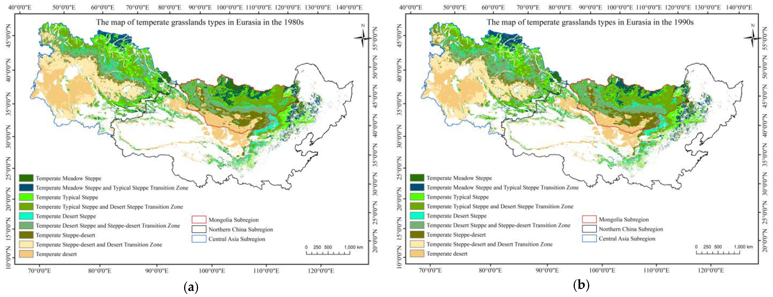
3.1. Classification of Temperate Grassland Types in Northern China in the 1980s

According to the proposed ARNCI formulas, ARNCI mapping of grassland can be carried out for classification application. By taking the ground truth data of the grassland types in Northern China in the 1980s as a standard, this study investigated their characteristic patterns and extended the analysis to other spatial and temporal scales. Figure 4 reveals that the variations of ARNCI between April and November are more representative. Considering the data processing workload, this study only utilized NDVI data from April to November.
The temporal resolution of this study is a decade, focusing on the classification of Eurasian temperate grassland types during the 1980s (1981–1990) and 1990s (1991–2000). To eliminate the influence of meteorological factors or sudden NDVI changes in a single year that could lead to misclassification of grassland types, this study employed the 10-year average monthly NDVI data to calculate the RNC. Based on the ARNCI formula, the maps of ARNCI from April to November for Northern China in the 1980s and 1990s were obtained (Figure 4).
By comparing the ground truth data of the Northern China temperate grassland types in the 1980s with the ARNCI maps, pixel-based ARNCI distribution ranges were calculated for the five temperate grassland types. Following the 3-sigma criterion [47], data cleaning was conducted by considering values within the range of mean ± 1.5 × standard deviation. The ARNCI thresholds for each type are shown in Figure 5. It was observed that the ARNCI values in the Northern China sub-region during the 1980s ranged from 0 to 1.1. Different grassland types exhibited distinct peak positions and varying value ranges. The ARNCI values gradually increased from temperate grassland desert to meadow, with a wider range span. There were also overlapping regions between adjacent grassland types. So, four transitional zones were proposed, namely, the temperate meadow steppe and typical steppe transition zone, the temperate typical steppe and desert steppe transition zone, the temperate desert steppe and steppe-desert transition zone, and the temperate steppe-desert and desert transition zone.
By utilizing the aforementioned method of ARNCI, classification thresholds were established for different grassland types and transitional zones in Northern China during the 1980s. Multiple thresholds were tried and evaluated using the experimental approach, and, finally, the threshold that yielded the best experimental results was selected for classification. According to Figure 5, the initial threshold range was tried, and then the threshold range was continuously adjusted through ten experiments to determine the range that achieved the highest accuracy. The thresholds and overall accuracy corresponding to the ten experiments conducted in Northern China are presented in Table 3.
An error matrix between the classification maps and the ground truth data was established to evaluate the classification results. Statistical tests showed that the threshold range of the eighth experiment yielded the highest classification accuracy. The evaluation of accuracy in this study was based on overall accuracy (OA), producer accuracy (PA), and user accuracy (UA). According to the accuracy evaluation results (Table 4), the overall classification accuracy in Northern China in the 1980s reached 75.3%. The classification accuracy was highest for the temperate desert, while the accuracy for temperate desert steppe and temperate steppe-desert was relatively lower. The error matrix revealed that some types were most likely misclassified as adjacent grassland categories, confirming the difficulty in distinguishing between adjacent grassland types. This highlights the necessity of establishing transitional zones.

3.2. Experiments of Spatial Extension Application

To further validate the applicability in spatial extent, the same experimental study was conducted on the other two research sub-regions, namely, Central Asia and Mongolia. The ARNCI thresholds and OA for the two sub-regions in the 1980s were obtained and are presented in Table 5 and Table 6, respectively.
Through experiments, the ARNCI thresholds and OA were obtained for the Central Asia and Mongolia sub-regions in the 1980s, which were 64.2% and 84.6%, respectively (as shown in Table 5 and Table 6). In Central Asia, the PA for the temperate meadow steppe was relatively low due to its small area in the overall region. Since the threshold value will be set according to the dominant grassland types, subjective factors will affect the classification accuracy of the category with a small area proportion. Similarly, in Mongolia, the relatively low proportion of temperate meadow steppe also led to some subjective classification errors and thus poorer classification performance. It is clear that that there were variations in classification accuracy in the three sub-regions. Overall, the three sub-regions achieved good overall classification accuracies, with the lowest accuracy in Central Asia, possibly due to the influence of different observation scales.
The results demonstrated that this method achieved satisfactory performance in the spatiotemporal expansion experiments, with relatively high overall accuracy. This confirmed the transferability of the method in both spatial and temporal domains. Therefore, this method can predict the spatial distribution of grassland types in the research area for the 1990s. By applying this method, the ARNCI thresholds were obtained for the three sub-regions in the 1980s, and ARNCI values were calculated for the 1990s. The ARNCI threshold ranges from the three sub-regions in the 1980s were used to predict the grassland type distributions for the 1980s and 1990s, resulting in the final maps of temperate grassland types for both periods (1980s and 1990s) in the Eurasian continent.

4. Discussion

From the comparison of the classification results (Figure 6), the overall prediction of spatial pattern of grassland type distribution in the 1990s is reasonable, and the temperate grassland presents a certain continuity in space. To provide a spatiotemporal analysis of changes, the Sankey diagram method was used for analyzing the transition between different grassland types in the three sub-regions (Figure 7). Taking full account of the complexity of grassland type transitions, this study focused on highlighting the major changes in types. It is worth noting that the area statistics are derived from remote sensing images and may differ from the actual areas.
The total area of temperate grassland in the three sub-regions of Northern China, Central Asia, and Mongolia, obtained from remote sensing imagery, is 2,037,593 km2, 5,165,535 km2, and 2,567,574 km2, respectively. Central Asia has the largest area.
In Northern China, the largest proportion of the area is occupied by temperate desert, with areas of 415,968 km2 and 438,137 km2 in the 1980s and 1990s, respectively. The second largest area is temperate typical steppe (354,344 km2 and 367,591 km2). The areas of temperate meadow steppe, desert steppe, and steppe-desert are relatively similar and occupy smaller proportions, with temperate steppe-desert being the smallest (with an average area of 360,968 km2). In Northern China, the areas of different grassland types exhibit stable changes, with fluctuations of only around 20,000 km2. The increase in the area of temperate desert is prominent and mainly occurs as a net conversion from the temperate steppe-desert and desert transition zone, particularly in the northeastern part of Xinjiang. The decrease in the area of temperate meadow steppe is attributed to a net conversion from the typical grassland transition zone, while the increase in temperate typical steppe indicates a net conversion from both the meadow steppe and desert steppe transition zone.
In Central Asia, temperate typical steppe and temperate desert cover relatively larger areas. Temperate typical steppe is the second largest type in Central Asia, with areas of 603,185 km2 and 511,094 km2 in the 1980s and 1990s, respectively. The areas of temperate desert are 863,598 km2 and 767,253 km2, while temperate meadow steppe has the smallest coverage, with only 75,257 km2 and 61,450 km2. In the Central Asia, except for the increase in the area of temperate steppe-desert, the other four grassland types show varying degrees of decrease. The area of temperate steppe-desert has increased by approximately 77,000 km2, as revealed in the Sankey diagram, primarily through conversions from the temperate steppe-desert and desert transition zone, with a small area of conversion from temperate desert (7324 km2). The decrease in temperate typical steppe and temperate desert is relatively similar, with areas of approximately 92,000 km2 and 96,000 km2, respectively. The decrease in temperate typical steppe is primarily attributed to conversions to the desert steppe transition zone (148,251 km2), with a smaller portion converting to the temperate meadow steppe (75,372 km2). The decrease in temperate desert is mainly due to net conversions to the temperate steppe-desert and desert transition zone, predominantly occurring in the eastern part of Turkmenistan. The changes in temperate meadow steppe and temperate desert steppe are relatively small, with most conversions occurring in neighboring transition zones or grassland types.
In Mongolia, temperate steppe-desert occupies the largest proportion, with areas of 422,874 km2 and 418,990 km2 in the 1980s and 1990s, respectively, followed by temperate desert (227,953 km2 and 277,410 km2). The average area of temperate meadow steppe is relatively small (93,335 km2). In Mongolia, temperate meadow steppe has the smallest average area, but it exhibits the largest changes, with a significant decrease of approximately 96,000 km2, of which around 93% converts to the typical steppe transition zone, with the remainder converting to the typical steppe. The changes in temperate desert are also relatively significant, mainly in terms of conversions. It primarily converts to the steppe-desert transition zone (56,594 km2), with a small portion converting to the temperate steppe-desert (10,810 km2). The areas of temperate typical steppe, desert steppe, and steppe-desert show relatively small changes, with steppe-desert remaining relatively stable. Overall, the areas exhibit net conversions, but there are mutual transitions between the adjacent transition zones.
In total, Central Asia represents the largest grassland sub-region in Eurasia. Temperate desert covers relatively larger areas both in Northern China and Central Asia, whereas temperate steppe-desert occupies the largest proportion in Mongolia. On the contrary, the areas of temperate meadow steppe cover the smallest area in the three sub-regions. In all three sub-regions, the spatial distribution of grassland types exhibits zonation and long-term characteristics. Based on the statistical data, the majority of area changes take place in adjacent grassland types and transition zones, with edge changes in each grassland type being more prominent and gradually stabilizing towards the center. Grassland types vary in their spatial dynamics, demonstrating differences in both contraction and expansion patterns, often characterized by localized shifts at the edges.
In view of classification accuracy evaluation and spatial pattern consistency, it is evident that the use of ARNCI for monitoring grassland types exhibits good transferability in both spatial and temporal domains. This index has shown good potential to serve as an effective indicator for monitoring continental-scale temperate grassland. However, this research heavily relies on the originally collected ground truth data, and therefore, when the proposed index is used for continental-scale grassland, there maybe remain some issues for collecting data. On the one hand, it is difficult to collect the same mapping accuracies when the data are produced by different countries. On the other hand, the collected data usually have inconsistent temporal-spatial resolution. Moreover, the ground truth grassland type data may be categorized by different classification systems. Finally, the ground truth grassland type data may be classified according to different standards even if the same classification systems were used. Taking into consideration the actual differences in data sources, temporal-spatial resolution, mapping methods, and accuracy, the zone partition method was used in this research. The Eurasian temperate grassland was divided into three sub-regions: Northern China, the five Central Asian countries, and Mongolia. From the result map in the 1980s, Mongolia has the highest classification OA of 84.6%, Northern China has the second higher classification OA of 75.3%, while Central Asia’s classification OA of 64.2% is the lowest. Analytically, the Mongolia map resulted from the collected ground truth data with the highest spatial resolution of 30 m, that of Northern China from the second higher spatial resolution of 1:1,000,000 map scale, and that of Central Asia from the lowest spatial resolution of 1:1:2,500,000 map scale. The difference of classification OA is reasonable if only the effect of spatial resolution of ground truth data is considered.
In fact, the proposed index method depends on the growth characteristics of the grassland vegetation, if the study area spreads across different climatic zones, which may result in different NDVI time-series characteristics in it. Indeed, Northern China has a larger climate zone span from west to east than Mongolia and Central Asia, which means that having more detailed sub-regions for Northern China maybe improve its classification OA. In addition, the growth of grasslands is influenced by diverse factors, such as climate, topography, and soil, and significant variations exist in these factors across different research sub-regions. Currently, this research emphasizes the methodological investigation for grassland type remote sensing classification rather than the qualitative understanding of grassland type changes and transitions. In future research, due to varying degrees of influence from environmental and topographical factors in different regions, it is essential to delve deeper into the selection of driving factors, the assessment of how different factors affect various regions, and the analysis of the mechanisms and driving factors of grassland type changes and transitions between them. This research can provide precise information for decision making in different regions, and assist in planning grassland health assessments, pastoral management, biodiversity conservation, and natural disaster risk management.

5. Conclusions

Temperate grasslands play a vital role in raising livestock and sustaining wildlife, and provide important ecosystem services. The distribution mapping of temperate grassland types from remote sensing data is a meaningful task for the sustainable development of the grassland. There are still no published maps on the classification of temperate grassland types at the Eurasian scale. This study proposed the ARNCI to obtain a classification map of Eurasian temperate grassland, basing on the time-series NDVI data for grassland types and the ground truth dataset derived from collected vegetation type maps and grassland coverage data of the study area. Four transition zone categories were proposed: temperate meadow steppe and typical steppe transition zone, temperate typical steppe and desert steppe transition zone, temperate desert steppe and steppe-desert transition zone, and temperate steppe-desert and desert transition zone. The overall classification accuracies showed a good performance, achieving 64.2–84.6%. Finally, distribution maps of Eurasian temperate grassland types in the 1980s and 1990s were obtained, and the temporal and spatial changes were analyzed. The following conclusions were drawn: Central Asia is the largest grassland sub-region in Eurasia; the proportions of different grassland types vary among sub-regions, with larger areas of temperate desert and smaller areas of temperate meadow steppe in general; the spatial distribution of grassland types exhibits zonation and long-term characteristics, with area changes mainly occurring in adjacent grassland types and transition zones, and the edge changes of each grassland type are more pronounced, becoming more stable toward the center; different grassland types also show varying degrees of contraction and expansion in space, with local edge movements.
In view of classification accuracy evaluation and spatial pattern consistency, the ARNCI demonstrated good transferability in time and space, reflecting the transitional zones between grassland types. It can effectively be applied to the classification and change research of Eurasian temperate grassland types. The ARNCI utilizes NOAA NDVI data, which are easy to obtain and process, has a long available time range, and facilitates long-term studies on Eurasian temperate grassland types. Generally, the classification OA is amazing, and the lower OA of Central Asia could be improved if more and better ground truth data could be collected in future research. For the continental-scale mapping of grassland types such as the Eurasian temperate grassland, which usually spreads across many countries, international collaborative research needs to be strengthened to collect more and better ground truth data using the same survey and processing methods when applying ARNCI into practice. Ecologically, the results firstly address the lack of remote sensing classification maps of Eurasian temperate grassland types, which can provide a promising tool for ecosystem assessments, such as biodiversity and ecological monitoring, as well as climate change adaptation, including improving land use models, reducing land erosion, and enhancing water resource management. However, this work lacks the study of the mechanisms and driving factors responsible for the transitions into different grassland types, which may be a research direction in future.

Author Contributions

Conceptualization, X.X.; methodology, X.X., J.T. and N.Z.; data collection, X.X., A.Z., W.W. and Q.S.; image processing, X.X. and Q.S.; validation, X.X., A.Z. and W.W.; data analysis, X.X., J.T., N.Z., A.Z. and W.W.; writing—original draft preparation, X.X.; writing—review and editing, X.X. and J.T.; supervision, J.T. and N.Z. All authors have read and agreed to the published version of the manuscript.

Funding

This research was funded by the CAS Strategic Priority Research Program (A), grant number XDA20050103, and Science & Technology Fundamental Resources Investigation Program, grant number 2022FY100100.

Institutional Review Board Statement

Not applicable.

Informed Consent Statement

Not applicable.

Data Availability Statement

Data are available from the authors upon reasonable request.

Acknowledgments

Thanks to NASA, NOAA, ECMWF, and other units for providing MODIS, NOAA, ERA5, and other data support. Special thanks to the Central Asia Regional Research Center, Institute of Botany, Chinese Academy of Sciences, and Inner Mongolia Grassland Survey and Planning Institute for the data support of this study.

Conflicts of Interest

The authors declare no conflict of interest.

References

  1. Coupland, R.T. Grassland Ecosystems of the World: Analysis of Grasslands and Their Uses; Cambridge University Press: Cambridge, UK, 1978. [Google Scholar]
  2. Archibold, O.W. Temperate grasslands. In Ecology of World Vegetation; Springer: Dordrecht, The Netherlands, 1995. [Google Scholar]
  3. White, R.P.; Murray, S.; Rohweder, M. Grasslands of the World; World Resources Institute: Washington, DC, USA, 2000. [Google Scholar]
  4. White, R.; Murray, S.; Rohweder, M. Pilot Analysis of Global Ecosystems: Grassland Ecosystems; World Resources Institute: Washington, DC, USA, 2000. [Google Scholar]
  5. Smelansky, I.E.; Tishkov, A.A. The Steppe Biome in Russia: Ecosystem Services, Conservation Status, and Actual Challenges. In Eurasian Steppes. Ecological Problems and Livelihoods in a Changing World; Plant and Vegetation; Werger, M., van Staalduinen, M., Eds.; Springer: Berlin/Heidelberg, Germany, 2012; Volume 6, pp. 45–101. [Google Scholar]
  6. Zhang, G.; Biradar, C.M.; Xiao, X.; Dong, J.; Zhou, Y.; Qin, Y.; Zhang, Y.; Liu, F.; Ding, M.; Thomas, R.J. Exacerbated grassland degradation and desertification in Central Asia during 2000–2014. Ecol. Appl. 2018, 28, 442–456. [Google Scholar] [CrossRef] [PubMed]
  7. Li, Y.; Wang, Y.; Song, J. Trends in extreme climatic indices across the temperate steppes of China from 1961 to 2013. J. Plant Ecol. 2019, 12, 485–497. [Google Scholar] [CrossRef]
  8. Meng, X.; Gao, X.; Li, S.; Li, S.; Lei, J. Monitoring desertification in Mongolia based on Landsat images and Google Earth Engine from 1990 to 2020. Ecol. Indic. 2021, 129, 107908. [Google Scholar] [CrossRef]
  9. Zhang, Y.; Wang, Q.; Wang, Z.; Li, J.; Xu, Z. Dynamics and Drivers of Grasslands in the Eurasian Steppe during 2000–2014. Sustainability 2021, 13, 5887. [Google Scholar] [CrossRef]
  10. Stoddart, L.A.; Smith, A.D. Range Management. Soil Sci. 1956, 81, 77. [Google Scholar] [CrossRef]
  11. Salisbury, E.J. The British Islands and their Vegetation. Nature 1939, 144, 305–306. [Google Scholar] [CrossRef]
  12. Moore, R.M. Australian Grasslands; Australian National University Press: Canberra, Australia, 1975. [Google Scholar]
  13. Watson, J.; More, J.A. Agriculture Science and Practice of British Farming, 3rd ed.; Oliver and Boyd: Edinburg, UK, 1949. [Google Scholar]
  14. You, M.Y.; Liu, X.B.; Bäumler, R.; Oliver, M.A. Grassland soils in the cool–arid–temperate ecozone (Steppe, grassland). In Encyclopedia of Soils in the Environment, 2nd ed.; Elsevier: Amsterdam, The Netherlands, 2023; Volume 4, pp. 299–318. [Google Scholar]
  15. Ren, S.L.; Chen, X.Q.; Lang, W.G.; Schwartz, M.D. Climatic Controls of the Spatial Patterns of Vegetation Phenology in Midlatitude Grasslands of the Northern Hemisphere. JGR Biogeosci. 2018, 123, 2323–2336. [Google Scholar] [CrossRef]
  16. Wikramanayake, E.; Akbarally, Z.; Wickramaratne, C. Grasslands and Savannas of South Asia. In Encyclopedia of the World’s Biomes; Elsevier: Cambridge, UK, 2020; pp. 800–813. [Google Scholar]
  17. Hansen, M.C.; Defries, R.S.; Townshend, J.R.G.; Sohlberg, R. Global land cover classification at 1km spatial resolution using a classification tree approach. Int. J. Remote Sens. 2000, 21, 1331–1364. [Google Scholar] [CrossRef]
  18. Loveland, T.R.; Reed, B.C.; Brown, J.F.; Ohlen, D.O.; Zhu, Z.; Yang, L.; Merchant, J.W. Development of a global land cover characteristics database and IGBP DIS-Cover from 1 km AVHRR data. Int. J. Remote Sens. 2000, 21, 1303–1330. [Google Scholar] [CrossRef]
  19. Friedl, M.A.; Mciver, D.K.; Hodges, J.C.F.; Zhang, X.Y.; Muchoney, D.; Strahler, A.H.; Woodcock, C.E.; Gopal, S.; Schneider, A.; Cooper, A.; et al. Global land cover mapping from MODIS: Algorithms and early results. Remote Sens. Environ. 2002, 83, 287–302. [Google Scholar] [CrossRef]
  20. Bartholome, E.; Belward, A.S. GLC2000: A new approach to global land cover mapping from Earth observation data. Int. J. Remote Sens. 2005, 26, 1959–1977. [Google Scholar] [CrossRef]
  21. Potapov, P.; Hansen, M.C.; Pickens, A.; Hernandez-Serna, A.; Tyukavina, A.; Turubanova, S.; Zalles, V.; Li, X.; Khan, A.; Stolle, F.; et al. The Global 2000–2020 Land Cover and Land Use Change Dataset Derived from the Landsat Archive: First Results. Front. Remote Sens 2022, 3, 856903. [Google Scholar] [CrossRef]
  22. Pi, W.; Du, J.; Bi, Y.; Gao, X.; Zhu, X. 3D-CNN based UAV hyperspectral imagery for grassland degradation indicator ground object classification research–Science Direct. Ecol. Inform. 2021, 62, 101208. [Google Scholar] [CrossRef]
  23. Yang, H.Y.; Du, J.M.; Wang, Y.; Zhang, Y.B.; Zhang, X.P.; Kang, Y.C. Classification Method of Grassland Species Based on Unmanned Aerial Vehicle Remote Sensing and Convolutional Neural Network. Trans. Chin. Soc. Agric. Mach. 2019, 50, 188–195. (In Chinese) [Google Scholar]
  24. Lu, B.; He, Y.H. Optimal spatial resolution of Unmanned Aerial Vehicle (UAV)-acquired imagery for species classification in a heterogeneous grassland ecosystem. GISci. Remote Sens. 2018, 55, 205–220. [Google Scholar] [CrossRef]
  25. Wu, Z.; Zhang, J.; Deng, F.; Zhang, S.; Zhang, D.; Xun, L.; Javed, T.; Liu, G.; Liu, D.; Ji, M. Fusion of GF and MODIS Data for Regional-Scale Grassland Community Classification with EVI2 Time-Series and Phenological Features. Remote Sens. 2021, 13, 835. [Google Scholar] [CrossRef]
  26. Meng, B.; Zhang, Y.; Yang, Z.; Lv, Y.; Chen, J.; Li, M.; Sun, Y.; Zhang, H.; Yu, H.; Zhang, J.; et al. Mapping Grassland Classes Using Unmanned Aerial Vehicle and MODIS NDVI Data for Temperate Grassland in Inner Mongolia, China. Remote Sens. 2022, 14, 2094. [Google Scholar] [CrossRef]
  27. Zhu, X.B.; Bi, Y.G.; Du, J.M.; Gao, X.; Zhang, T.; Pi, W.; Zhang, Y.; Wang, Y.; Zhang, H. Research on deep learning method recognition and a classification model of grassland grass species based on unmanned aerial vehicle hyperspectral remote sensing. Sensors 2023, 69, 3–11. [Google Scholar] [CrossRef]
  28. Wen, Q.; Zhang, Z.; Liu, S.; Wang, X.; Wang, C. Classification of Grassland Types by MODIS Time-Series Images in Tibet, China. IEEE J. Sel. Top. Appl. Earth Obs. Remote Sens. 2010, 3, 404–409. [Google Scholar] [CrossRef]
  29. Qiao, X.Y.; Zhu, H.Z.; Shao, X.M.; Zhong, H.P.; Zhou, L.L.; Wu, Z.W. Automatic classification of grassland type in Xinjiang Ili based on spatial interpolation of remote sensing and other data. Acta Pratacult. Sin. 2017, 26, 30–45. (In Chinese) [Google Scholar]
  30. Zhou, W.; Yang, F.; Qian, Y.R.; Li, J.L. Typical grassland classification and precision evaluation based on remote sensing data in the northern slope of Tianshan Mountain. Pratacult. Sci. 2012, 29, 1526–1532. (In Chinese) [Google Scholar]
  31. Wang, S.; Zhang, L.L.; Lin, W.B.; Huang, Q.; Song, Y.; Ye, M. Study on vegetation cover and land use change in Guangdong Province based on MODIS Normalized Vegetation Index. Acta Ecol. Sin. 2022, 42, 2149–2163. (In Chinese) [Google Scholar]
  32. Wang, S.Q. Fractional Vegetation Cover in the Source Area of Yellow River Extraction and Change Analysis Based on Temporal NDVI Data of Landsat and MODIS. Master’s Thesis, China University of Geosciences, Beijing, China, 2020. (In Chinese). [Google Scholar]
  33. Wang, Z.X.; Liu, C.; Zhao, B.R. Potentials and limitation of AVHRR for grassland classification in Xilinguole, Inner Mongolia. J. Nat. Resour. 2003, 6, 704–711. (In Chinese) [Google Scholar]
  34. Yang, X.; Yang, T.; Ji, Q.; He, Y.; Ghebrezgabher, M.G. Regional-scale grassland classification using moderate-resolution imaging spectrometer datasets based on multistep unsupervised classification and indices suitability analysis. J. Appl. Remote Sens. 2014, 8, 1261–1264. [Google Scholar] [CrossRef]
  35. Xu, D.; Chen, B.; Shen, B.; Wang, X.; Yan, Y.; Xu, L.; Xin, X. The Classification of Grassland Types Based on Object-Based Image Analysis with Multisource Data. Rangel. Ecol. Manag. 2018, 72, 318–326. [Google Scholar] [CrossRef]
  36. Bai, Y.F.; Wu, J.G.; Pan, Q.M.; Huang, J.; Wang, Q.; Li, F.; Buyantuyev, A.; Han, X. Positive linear relationship between productivity and diversity: Evidence from the Eurasian Steppe. Appl. Ecol. 2007, 44, 1023–1034. [Google Scholar] [CrossRef]
  37. Chen, Y.L.; Li, J.L.; Sun, G.Z.; Gang, C. Spatiotemporal dynamics of grassland net primary productivity and its response to climate change in the Temperate Eurasian Steppe 1982–2008. Acta Ecol. Sin. 2017, 26, 1–12. (In Chinese) [Google Scholar]
  38. Jiao, C.C.; Yu, G.R.; He, N.P.; Ma, A.; Ge, J.; Hu, Z. The spatial pattern of grassland aboveground biomass and its environmental controls in the Eurasian steppe. Acta Geogr. Sin. 2016, 71, 781–796. (In Chinese) [Google Scholar] [CrossRef]
  39. 1:1,000,000 China Grassland Resource Mapping Committee. 1:1 Million Atlas of Grassland Resources in China; China Cartographic Publishing House: Beijing, China, 1993. [Google Scholar]
  40. Wang, J.L.; Cheng, K.; Zhu, J.X.; Liu, Q. Development and Pattern Analysis of Mongolian Land Cover Data Products with 30 Meters Resolution. J. Geo-Inf. Sci. 2018, 20, 1263–1273. (In Chinese) [Google Scholar]
  41. International Knowledge Centre for Engineering Sciences and Technology (IKCEST). Available online: http://drr.ikcest.org/info/939bc (accessed on 28 September 2023).
  42. Google Earth Engine. Available online: https://earthengine.google.com/ (accessed on 28 September 2023).
  43. Gorelick, N.; Hancher, M.; Dixon, M.; Ilyushchenko, S.; Thau, D.; Moore, R. Google Earth Engine: Planetary-scale geospatial analysis for everyone. Remote Sens. Environ. 2017, 202, 18–27. [Google Scholar] [CrossRef]
  44. Jia, S.X. Discussion on the type classification of Chinese steppe. Chin. Steppe 1980, 1, 1–13. (In Chinese) [Google Scholar]
  45. Guo, K.; Fang, J.Y.; Wang, G.H.; Tang, Z.-Y.; Xie, Z.-Q.; Shen, Z.-H.; Wang, R.-Q.; Qiang, S.; Liang, C.-Z.; Da, L.-J. A revised scheme of vegetation classification system of China. Chin. J. Plant Ecol. 2020, 44, 111–127. (In Chinese) [Google Scholar] [CrossRef]
  46. Ma, M.G.; Wang, J.; Wang, X.M. Advance in the Inter-annual Variability of Vegetation and Its Relation to Climate Based on Remote Sensing. J. Remote Sens. 2006, 10, 421–431. [Google Scholar]
  47. Li, K.Z.; Gupta, R.; Drayton, A.; Barth, I.; Conteduca, D.; Reardon, C.; Dholakia, K.; Krauss, T.F. Extended Kalman Filtering Projection Method to Reduce the 3 sigma Noise Value of Optical Biosensors. ACS Sens. 1990, 5, 3474–3482. [Google Scholar] [CrossRef]
Figure 1. Coverage of temperate grassland types in Eurasia. The figure on the left shows the location of the study area on a global scale; the figure on the right presents the ground truth data in the 1980s.
Sustainability 15 14973 g001
Figure 2. Monthly variation of NDVI in Inner Mongolia in 1989.
Sustainability 15 14973 g002
Figure 3. Monthly mean NDVI of different grassland types in Northern China in 1989.
Sustainability 15 14973 g003
Figure 4. ARNCI maps of Northern China in the 1980s and 1990s: (a) showing the ARNCI distribution of Northern China in the 1980s; and (b) showing the ARNCI distribution of Northern China in the 1990s.
Sustainability 15 14973 g004
Figure 5. Pixel-based ARNCI statistic of different grassland types in Northern China in the 1980s.
Sustainability 15 14973 g005
Figure 6. Maps of temperate grasslands types in Eurasia in the 1980s and 1990s: (a) 1980s; (b) 1990s.
Sustainability 15 14973 g006
Figure 7. Eurasian temperate grassland areas and Sankey maps in the 1980s and 1990s. The letters (a,b,c) represent the cover area, area changes, and Sankey diagrams of grassland types, respectively, in different regions. The hyphenated numbers (1), (2), and (3) represent Northern China, Central Asia, and Mongolia, respectively.
Sustainability 15 14973 g007
Table 1. Summary for ground truth data.
Data TypeStudy Sub RegionResolution
Vegetation type map of the five Central Asian countries (1980s)Central Asia1:2,500,000
Vegetation type map of the People’s Republic of China (1980s)Northern China1:1,000,000 [39]
Grassland coverage data of Mongolia (1990)Mongolia30 m [40]
Table 2. Comparison between the first national survey of grassland resource classification system (on the left in this table) and the temperate grassland type classification system of this paper (on the right in this table).
NumberGrassland Type (Classification System of First
National Survey of Grassland Resources) [45]
Grassland Type (Temperate Grassland Type Classification System of This Paper Adjusted from the Left)
1Temperate meadow steppeTemperate meadow steppe
2Temperate steppeTemperate typical steppe
3Temperate desert steppeTemperate desert steppe
4Temperate desertified steppeTemperate steppe-desert
5Temperate desertTemperate desert
Table 3. ANRCI thresholds and accuracy of ten experiments in Northern China in the 1980s.
Types1st2nd3rd4th5th6th7th8th9th10th
A(0, 0.05](0, 0.06](0, 0.07](0, 0.07](0, 0.08](0, 0.08](0, 0.08](0, 0.08](0, 0.08](0, 0.08]
B(0.05, 0.07](0.06, 0.7](0.07, 0.09](0.07, 0.1](0.08, 0.1](0.08, 0.1](0.08, 0.1](0.08, 0.11](0.08, 0.1](0.08, 0.1]
C(0.07, 0.11](0.7, 0.11](0.09, 0.12](0.1, 0.13](0.1, 0.13](0.1, 0.13](0.1, 0.14](0.11, 0.14](0.1, 0.14](0.1, 0.14]
D(0.11, 0.15](0.11, 0.16](0.12, 0.19](0.13, 0.19](0.13, 0.19](0.13, 0.19](0.14, 0.19](0.14, 0.19](0.14, 0.19](0.14, 0.19]
E(0.15, 0.22](0.16, 0.2](0.19, 0.23](0.19, 0.23](0.19, 0.25](0.19, 0.25](0.19, 0.25](0.19, 0.25](0.19, 0.23](0.19, 0.25]
F(0.22, 0.34](0.2, 0.33](0.23, 0.35](0.23, 0.35](0.25, 0.35](0.25, 0.34](0.25, 0.33](0.25, 0.33](0.23, 0.33](0.25, 0.33]
G(0.34, 0.6](0.33, 0.6](0.35, 0.6](0.35, 0.6](0.35, 0.6](0.34, 0.6](0.33, 0.6](0.33, 0.6](0.33, 0.6](0.33, 0.6]
H(0.6, 0.75](0.6, 0.75](0.6, 0.75](0.6, 0.75](0.6, 0.75](0.6, 0.75](0.6, 0.75](0.6, 0.75](0.6, 0.77](0.6, 0.77]
I(0.75, 1.5)(0.75, 1.5)(0.75, 1.5)(0.75, 1.5)(0.75, 1.5)(0.75, 1.5)(0.75, 1.5)(0.75, 1.5)(0.77, 1.5)(0.77, 1.5)
OA (%)67.865.969.570.172.272.674.175.374.875
A: Temperate meadow steppe; B: temperate meadow steppe and typical steppe transition zone; C: temperate typical steppe; D: temperate typical steppe and desert steppe transition zone; E: temperate desert steppe; F: temperate desert steppe and steppe-desert transition zone; G: temperate steppe-desert; H: temperate steppe-desert and desert transition zone; I: temperate desert.
Table 4. Accuracy evaluation in Northern China in the 1980s.
Types of GrasslandsTemperate Meadow SteppeTemperate Typical SteppeTemperate Desert SteppeTemperate Steppe-DesertTemperate
Desert
PA (%)
Temperate meadow steppe127,85533,495162739618178.2
Temperate typical steppe18,304264,84239,442687422,13375.3
Temperate desert steppe47243,08694,18218,20025,54151.9
Temperate
steppe-desert
1371364125,65652,53931,81145.7
Temperate desert441290525926,602392,68292.2
UA (%)86.476.556.750.283.1/
OA (%): 75.3
OA: overall accuracy; PA: producer accuracy; and UA: user accuracy.
Table 5. ARNCI of different temperate grassland types in the other two sub-regions in the 1980s.
Grassland TypesCentral AsiaMongolia
A(0, 0.06](0, 0.05]
B(0.06, 0.16](0.05, 0.07]
C(0.16, 0.2](0.07, 0.15]
D(0.2, 0.27](0.15, 0.35]
E(0.27, 0.3](0.35, 0.4]
F(0.3, 0.45](0.4, 0.65]
G(0.45, 0.65](0.65, 0.75]
H(0.65, 0.85](0.75, 0.9]
I(0.85, 2)(0.9, 2)
OA (%)64.284.6
A: Temperate meadow steppe; B: temperate meadow steppe and typical steppe transition zone; C: temperate typical steppe; D: temperate typical steppe and desert steppe transition zone; E: temperate desert steppe; F: temperate desert steppe and steppe-desert transition zone; G: temperate steppe-desert; H: temperate steppe-desert and desert transition zone; I: temperate desert.
Table 6. Accuracy evaluation in the other two sub-regions in the 1980s.
Central AsiaMongolia
Grassland TypesPA (%)UA (%)PA (%)UA (%)
Temperate meadow steppe22.768.18.231.8
Temperate typical steppe57.875.677.960.3
Temperate desert steppe41.232.748.852.6
Temperate steppe-desert41.240.496.195.9
Temperate desert89.377.199.998.9
OA (%)64.284.6
Disclaimer/Publisher’s Note: The statements, opinions and data contained in all publications are solely those of the individual author(s) and contributor(s) and not of MDPI and/or the editor(s). MDPI and/or the editor(s) disclaim responsibility for any injury to people or property resulting from any ideas, methods, instructions or products referred to in the content.

