Article

Heritage Trasimeno: From Mapping the Dynamics of Landscape Transformation to Possible Strategies for Heritage Use

Department of Civil and Environmental Engineering, University of Perugia, 06125 Perugia, Italy
*
Author to whom correspondence should be addressed.
Sustainability 2023, 15(20), 14777; https://doi.org/10.3390/su152014777
Submission received: 21 July 2023 / Revised: 12 September 2023 / Accepted: 10 October 2023 / Published: 12 October 2023
(This article belongs to the Special Issue Visualising Landscape Dynamics)

Abstract

:
This research concerns the analysis of the evolution of the landscape of Lake Trasimeno, in the Umbria region (Italy). The case study is marked by an inconsistent settlement pattern. Nevertheless, it retains wide glimpses of unspoilt territory, still tied to its original values. The same landscape transformations offer a series of opportunities for recomposition. These require representative instruments capable of interpreting and guiding the valorisation of the rich heritage, all this also considering the strong tourism value of the area under study. From a methodological point of view, the contribution is structured in three main phases: a first phase of studying the tourism dynamics in the area; a second phase of mapping the identity and evolutionary characteristics of the area; a third phase of conception and development of three project proposals aimed at enhancing the identity characteristics of the place and at favouring its usability with a view to sustainable tourism. The restitution and interpretation of the analysis and mapping phases (albeit partial, because they are limited to only a part of the lake’s coastline) become fundamental for identifying sustainable project strategies, as they are integrated with the social, cultural and economic characteristics of the area.

1. Introduction

Lake Trasimeno has always been a precious resource for Umbria (Figure 1). The lake extends for 45 kilometres of coastal perimetre and a bathing surface area of about 128 square kilometres from which three islands emerge, each with its own identity: the Maggiore, characterised by an ancient village; the Minore, almost uncontaminated in its naturalistic features; the Polvese, rich in historical and artistic pre-existences [1,2,3,4]. The lake is characterised by its peculiar shallowness and characteristic greenish colour, such that Cesare Brandi described it as “a veil of water on a meadow” [5] (p. 11). As a result of the protracted lack of a natural outlet, settlement phenomena have historically been prevented by the marshy nature of the banks, forcing populations to take shelter in the healthier hillside sites (Castel Rigone, Magione, Montecolognola, Paciano, Panicale, San Savino, Tuoro) and occupy the few rocky promontories present (Castiglione del Lago, Monte del Lago, Passignano, San Feliciano) [6]. After the completion of the hydraulic arrangement of the perilacustrine territory, the 20th century saw a settlement explosion characterised by a predominantly tourism purpose that overcame the lack of a direct outlet to the sea. The coastline was progressively occupied by semi-permanent campsites as well as pseudo-swimming establishments equipped with sandy beaches. These dynamics have affected the figurative order inherited from the past, altering the pleasant and spontaneous image portrayed over time by the most famous Umbrian painters, from Pietro Vannucci to Gerardo Dottori [7], and depicted by the numerous northern European travellers on the Grand Tour: from Johann Wolfgang von Goethe to George Byron. Since the second half of the 20th century, the expansion process has been driven by two distinct phenomena underlying the main morphological characteristics of the areas around Lake Trasimeno. In the north, the sloping course of the hills and of the road axes towards the lake leaves the historic villages in a barycentric position, forcing a homogeneous spread of new settlements along the coast (as in the case of Passignano sul Trasimeno), while on the south-western side, where the historic nuclei are set in flat sites, there is a radial expansion around the old settlements and the road network of exclusive local relevance (as in the case of Magione). In the past, the fertility of the land and the abundance of water determined the strategic value of these places and guaranteed a coherence between the variation of the figurative image and the transformation of the Trasimeno landscape. Today, however, the Trasimeno landscape is particularly complex. In fact, it is marked by haphazard and inconsistent settlement action, while at the same time preserving vast uncontaminated spaces, still intimately tied to their original values that still make it attractive for tourism. It is for these very reasons that this research intends to investigate the possible ways of enhancing the tourism vocation of the Lake Trasimeno area in relation to possible strategies of sustainable and responsible development. To this end, from a methodological point of view, the research is divided into three main phases: a first phase that concerns the study of the tourism dynamics underway in the context under study; a second phase of mapping the identity and evolutionary characteristics of the area; a third phase of the conception and development of three project proposals aimed on the one hand at enhancing the identity characteristics of the place and on the other at favouring its usability from a sustainable tourism perspective.

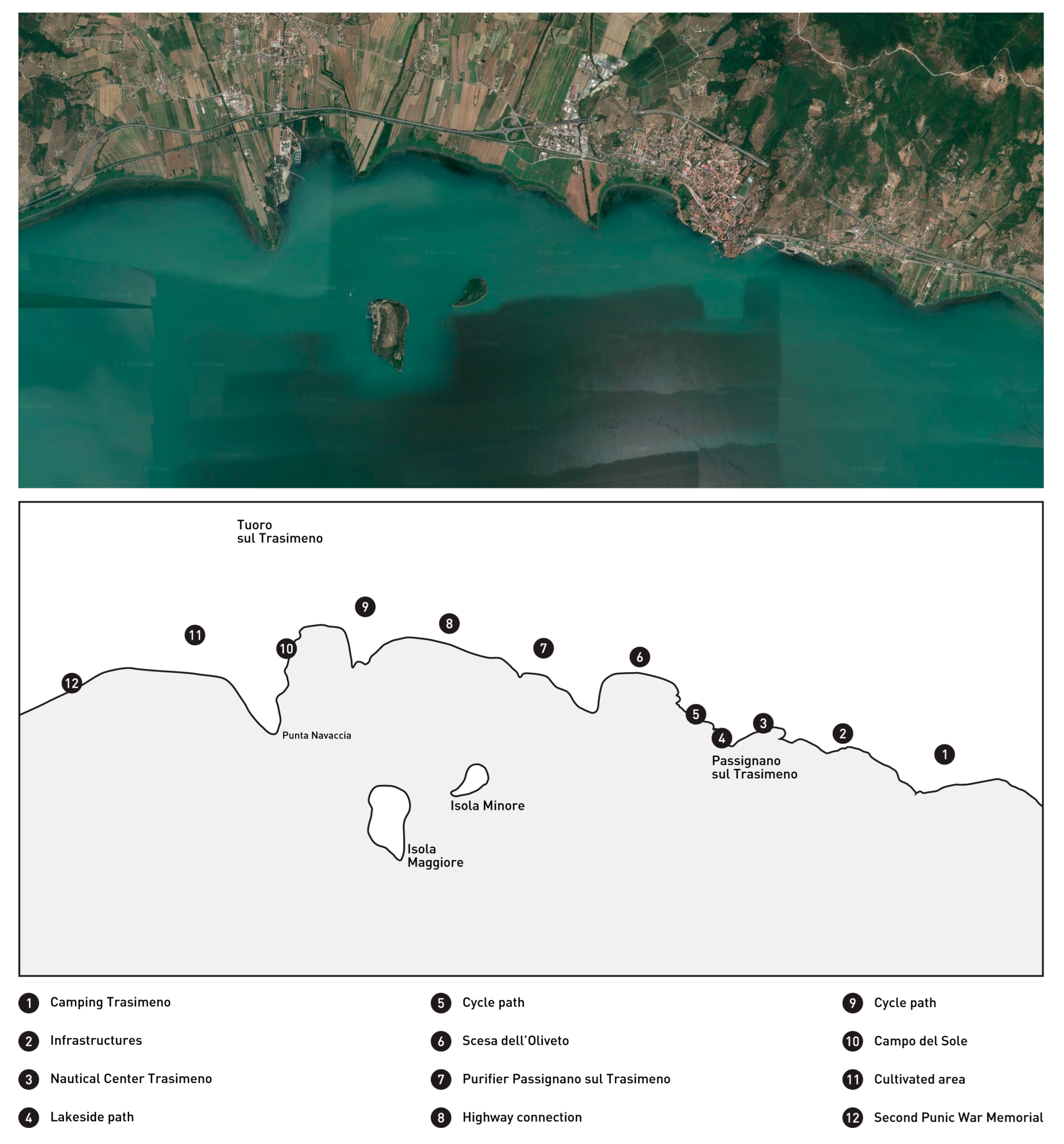
2. Tourism in the Lake Trasimeno Area

Statistics for the year 2022 show that the Lake Trasimeno area is among the most visited destinations in the Umbria region. Among the ten most popular destinations for foreign tourists are Castiglione del Lago, on the western coast, and Passignano sul Trasimeno, on the northern coast. The two locations, in fourth and fifth place in the ranking, respectively, overtake important urban centres such as Gubbio, Spoleto and Terni and record stay times of between two and three days [8]. The Trasimeno area plays a strategic role in the planning of investment policies for the regional territory and represents a development factor for the entire Umbrian economy. In order to achieve a trajectory of sustainable development, the main lines of action, referable both to the Strategia Nazionale Aree Interne Regione Umbria [9] and to the Piano Nazionale di Ripresa e Resilienza (PNRR) [10], go through the protection and enhancement of the environmental, natural, landscape and cultural heritage referable both to the lake itself and to the historical villages and centres of more recent expansion linked to it. Also with a view to preventing abandonment and depopulation phenomena, the line of action ‘Enhancement of the region’s inland areas and villages’ (Valorizzazione delle aree interne e dei borghi della regione) identified within the PNRR supports the economic, social, environmental and cultural dimensions by proposing strategies aimed at fostering an active relationship with the communities concerned and the authentic experience of the tangible and intangible elements that identify the territory, with a view to ‘heritage tourism’ [11]. From a theoretical point of view, this approach falls fully within a general framework related to sustainable tourism that has been spreading at European level since the late 1980s [12]. In fact, it is a concept that takes shape starting from the transposition of the more general concept of sustainability to the sphere of tourism. As is well known, sustainable development means a mode of development that does not compromise the ability of future generations to satisfy their needs [13]. Based on this concept, the World Tourism Organisation defines the principle of sustainable tourism as those activities that are developed in such a way that they do not alter the environment (natural, social and artistic) and do not hinder the development of other social and economic activities [14]. The definition of sustainable tourism was then formalised in 1995 by ICOMOS in the Lanzarote Tourism Charter and was further supplemented and expanded in the following years [15]. In general, however, a constant aspect in the definition of responsible tourism in Europe concerns the focus on local communities. In fact, these are expected to participate actively to help determine the development models of the relative territories. This issue finds concrete application within the Lake Trasimeno area. To this end, a fundamental role is played by the so-called ‘Landscape Contract’, set up with a special resolution in December 2013 and aimed at identifying possible directions for the enhancement of the Trasimeno territory, also thanks to the active involvement of the local populations, in an attempt to identify a shared and landscape-sustainable development perspective [16]. From an operational point of view, the trajectories of tourism development in the Trasimeno area are based on a series of actions mainly aimed at promoting the most representative elements of the area’s identity. In this respect, it is particularly important to redevelop and systematise the network of cycle paths, bridle paths, trails and paths currently present in order to build a model of outdoor tourism based on soft mobility and on the rediscovery of the territory [17] that includes the elements most representative of the identity of the local community [10]: from the typical agro-food products to the widespread architectural heritage. In addition to being served by a physical network of routes along the coast, the lake is affected by a virtual network of inland routes. In this case, the planned actions are aimed at the urgent need to stabilise the level of the lake, both through water resource management methods (the balance of which is strongly linked to the contribution of the Chiascio river) and through appropriate ways of using the water, encouraging the use of electric boats.
Bearing in mind the strong tourism value of the area in question, the transformations on the lake’s landscape, whether already implemented or planned, offer a palimpsest of opportunities for reconnection and recomposition, which require representative instruments capable of interpreting, presenting and guiding the valorisation, accessibility and enjoyment of the rich environmental and cultural heritage.

3. Heritage Mapping/Interpretation

The significance of mapping a territory or the phenomena manifesting in that territory has taken on an increasingly broad and complex meaning in recent decades. Originating in the ‘cultural turn’ of the second half of the 20th century, it has transversally invested cultural studies [18,19], recognising a crucial role for cartography. While maintaining the subjective and interpretative nature of the action, which presupposes a selection of data deemed significant and their representation according to a specific graphic code, the updating of available technological tools and the progressive computerisation of spatial geographic data have today made map production procedures democratically accessible, offering, moreover, a substantial amount of data for critical reading by contemporary cartographers, which allow them to effectively and immediately visualise phenomena underlying complex territorial geographies [20]. In the era of cybercartography [21,22], the map explores topics of social interest and allows interactive use, sometimes including elements of multisensoriality accessible through multimedia interfaces in an immersive manner [23]. In this context, even the inexperienced user can try out navigation experiences that are significantly different from those offered by traditional cartography; moreover, cartographic production is no longer the prerogative of specialists alone, but of an increasingly broader public of operators with extremely diverse cultural backgrounds and knowledge needs. The new way of looking at cartography [24] now allows attention to be focused on the dynamic quality of mapping, which becomes the primary objective of the map and which is intended to accompany the equally dynamic conditions of the territory or phenomena under investigation. Indeed, the rapidly evolving nature of information and data, combined with an approach aimed at monitoring, even in the short term, territorial dynamics for political-administrative management purposes, leads to the need for flexible mapping that can be easily updated over time.
This aspect becomes even more decisive if one takes into account the target user of the map and his demand for interaction and customisation according to a ‘user-centred’ attitude. This updating of the act of mapping also entails an extension of the information to be selected for the purposes of map construction; whereas in traditional cartography we witnessed the recording of mere geographical data with the objective of maximum objectivity of representation, in contemporary cartography the perspective is broadened and, also in the light of the renewed definition of cultural heritage (and consequently landscape) extended to intangible values, the perceptive, emotional and experiential dimensions of the map are discovered [25,26,27]. Within the framework defined by the fields of psychogeography [28,29] and emotional geography [30], it becomes possible to detect and map information related to individual perception, multisensoriality, and emotional state, from which novel cartographic systems whose characters are constantly being updated can be derived.
Reference experiences such as the Tranquillity maps designed to detect the level of tranquillity perceived by the inhabitants of a territorial area [31] or the Emotional maps developed by Christian Nold [32], in which users, placed in conditions of partial sensory deprivation, are asked to detect the sensations felt along an urban route, but above all the dynamic and interactive ‘multidimensional’ maps developed by Forensic Architecture and capable of having a decisive impact on the current political scenario, can guide the construction and development of an effective mapping and interpretation of the transformations of the Trasimeno landscape. Also relevant to the present study is the emotional mapping project of Lake Bracciano, based on an experiential survey aimed at “representing and mapping the perception of a landscape and the cultural values attributed to it” [33] (p. 5). The construction of maps based on individual perceptions of landscape qualities can indeed act as an interpretative filter, playing a socio-cultural role that is projected onto the landscape itself, helping to define its imagery and influencing its perceptions and future transformations [34].

3.1. Mapping Methodology

In relation to this specific case, the reading of the transformation dynamics of the Trasimeno territory aims to take into account the complex system of values that over time have been stratified over the entire basin of influence of the lake. The first step assumes as sample territory the coastal strip, where the material traces of the most radical landscape modifications are concentrated due to the inescapable presence of the water element. Here the mapping actions are focused, in order to examine as a priority the signs currently present near the coast, interpreting them as the result of past transformation dynamics. Indeed, over the centuries the coastline has gone through distinctly different, if not opposing, uses and functions: a protective device but at the same time a front exposed to attack during the Middle Ages (as evidenced by the rise of numerous fortified architectures on the shores of the lake and its islands); an unspoilt naturalistic place but at the same time a mass tourist destination; a source of sustenance through land cultivation and fishing but at the same time a resource denied during drought periods. The diversity of uses is still legible in the strong heterogeneity of the material evidence along the shoreline, which, when put together, makes it possible to reconstruct a narrative of the lake history, its values and its multiple identity.
The methodology involves two main stages. Initially, the comparison between orthophoto images allows a general reading of the transformations of the perilacustrine territory, showing some macroscopic modifications. Based on some initial deductions, a portion of territory is taken as the sample for the mapping action focusing perceptive and multi-sensorial aspects, in order to collect data from a multisensorial and experiential survey. The next phase, still undeveloped, consists in extending the mapping to the entire perimetre of the coastline, in order to achieve an overall reading.
a.
Ortophoto comparison
An initial survey of the anthropic-derived transformations that have characterised the Trasimeno coastline can be read by comparing aerial images of the last 70 years (Figure 2), which highlight both the fluctuations in water levels and the progressive consolidation and diversification of settlement dynamics, with the specialisation of certain functional areas. The images under consideration are available from the institutional database of the Umbria Region (siat.regione.umbria.it) and refer to six photographic surveys: IGM-GAI 1954–1955, Ortophoto 1:10,000 1977, Digital Ortophoto AIMA 1997, Digital Ortophoto TerraItaly TM NR 2005, Ortophoto Consorzio TeA 2014 and Google TerraMetrics 2023. A comparison of the images shows how the level fluctuations in the extreme south-eastern, central north coast and central west coast segments, in the immediate surroundings of the settlements closest to the water, result in the presence of under-utilised buffer areas, lacking figurative identity and lying between very different functional areas. Indeed, despite the chronological continuity of territorial transformations, one aspect that characterises the coastal strip is the alternation of very heterogeneous features, differently influenced by human action. Thus, along the coast there is a succession of sections dedicated to the agricultural cultivation of the soil, whose peculiar shape of a thin parcel elongated towards the water (pedate) is a strongly characterising element; sections on which touristic receptive activities insist, in which anthropisation has led to a degradation of the original lacustrine habitat, on the incorporation of sand and the construction of beaches and camping sites; sections marked by the infrastructural network that runs close to the water surface, which appears as dynamic observation points of the lacustrine landscape; sections marked by dense and compact historicised settlement, which take on the value of a destination for cultural tourism and which are in the most prominent centres characterised by the presence of a port for transfer to the islands. The Trasimeno coastline was the subject of previous PRIN research dedicated to the monitoring and requalification of Italian coastal strips [35], which highlighted the main vulnerabilities of the coastline and identified three initial opportunities for possible figurative requalification in correspondence with the centres of Passignano sul Trasimeno, Sant’Arcangelo and Castiglione del Lago. The compromising of the original landscape caused by an improper tourist model has led to situations of contamination between the natural environment and the anthropic environment, which are distinguished more by friction than by integration.
b.
Multisensory mapping
The goal of conducting a multisensory mapping of the Lake Trasimeno coastal strip guided the setting up of an initial survey project that would impartially take into account both the main evolutionary dynamics to which the coast has been subjected and the now historicised anthropic transformations. In this sense, the mapping project was conceived with an objective gaze, superimposing an uncritical reading concerning the time and typology of transformations and relative to objective and measurable perceptions. Multisensory perception appeared to be a significant key precisely because of the possibility of mapping users’ sensations regardless of their prior knowledge of the area and thus defining a view predominantly referring to the current modes of use of the coastal path.
The mapping project was started on the northern segment of the coastal perimetre, already analysed during the previous PRIN research; the stretch considered extends for a length of approximately 10 km and appeared relevant due to the presence of numerous points of interest and to the proximity of the two islands Maggiore and Minore, which can be reached from two moorings (Passignano sul Trasimeno and Tuoro-Punta Navaccia) out of the four distributed along the entire coastline of the basin (Figure 3).
The surveyed route runs parallel to the coastline, approaching it at significant points, and is entirely practicable on foot or by bicycle. Within this stretch, the points of interest have been selected based on the specialisation of the areas and the heterogeneity of the functions present, which appears to be relevant precisely because of its variability in a relatively short overall extension of the stretch. The points of interest under consideration include naturalistic and otherwise man-made areas and seem to be arranged at fairly regular intervals of approximately 1 km in length. This characteristic also facilitates the carrying out of the survey campaign, as it allows the stretch to be easily covered on foot in a time span of a few hours, permitting the data recording in a single day. The diversity of uses is reflected in the sequence of attraction points, which include tourist sites (campsites, lakeside paths, nautical centre), agricultural areas (pedate or thin strips of cultivated land) and nature areas (scese or calate to the lake with a jetty), functional areas (intersections between infrastructures, water purification plant) and sites of cultural interest (the Campo del Sole sculpture park and the memorial to the Second Punic War).
There are not many experiences of multisensory mapping presented by the scientific literature; a first, significant reference [36] proposed a methodology for recording sensory data in an urban landscape. The presented mapping proposes a systematisation of the detection of multisensory perceptions, taking into account the five senses and providing a recording tool with normalised and comparable value scales. Thus, the purpose of the survey was to record the multisensory perceptions encountered along the route at points of interest. Documentation of perceptions was made using a survey form organised into four sections, each relating to a sensory stimulus; there are four senses considered, namely sight, touch, hearing and smell (except taste). The following were taken into consideration: visual stimuli, referring to the identification and quantification of colours and architectural elements in the landscape; tactile stimuli, referring to the identification and quantification of wind, heat and the sensations expressed by the materials of flooring and supports; sound stimuli, referring to the identification and quantification of the sounds and noises present; olfactory stimuli, referring to the identification and quantification of the perceived smells. An overall assessment of perceived visual, tactile, auditory and olfactory well-being was also requested for each of the stimulus categories detected. This had to be expressed qualitatively on a five-level scale whose extremes were unpleasant and pleasant, respectively.

3.2. Mapping Results

The initial outcomes of the mapping revealed several significant aspects. Concerning visual detection, chromatic perceptions referring to the colours of natural elements (vegetation, water, sky) and architectural perceptions referring to the historicised settlements are predominant, with a constant prevalence of the naturalistic component over the architectural component and with a substantial balance between overall pleasant and unpleasant perception. Concerning tactile detection, perceptions referring to the presence of wind and the sensation of heat are predominant, with less frequent reporting of perceptions referring to materials (wood, stone) and again with a substantial balance between pleasant and unpleasant overall perception. Concerning sound detection, two types of stimuli are predominant, respectively: natural (referring to the presence of sounds such as wind rustling, water noise and animal cries) and artificial (referring to the perception of sounds such as the passage of cars and other vehicles along road infrastructure and plant noise), with frequent reporting of the perception of absolute silence and with an overall assessment of sound perceptions more shifted toward the unpleasant extreme. Concerning olfactory detection, perceptions referring to the natural component (vegetation) are predominant, with a peak of detection of unpleasant perceptions at point 7 of the itinerary (purifier Passignano sul Trasimeno) related to the presence of sewage substances and with a substantial shift of the overall assessment towards the pleasant extreme.
The not large number of the initial sample of users participating in the mapping (30 students) allowed at this stage only a partial analysis, which, however, has already provided the first useful elements to optimise the survey form. The mapping performed so far can be interpreted in this sense as a preliminary test, useful to validate the survey instruments employed. The first critical consideration highlights the need to extend the mapping to cover the entire extent of the coastline, so that an overall reading can be obtained that is not affected by internal imbalances. Concerning the density of the selected points of interest, the positioning at regular intervals spaced 1 km apart will allow, once the project is extended to the entire coastline, for detecting information related to about 50 points, to which additional significant points may be added in a future perspective, either located at a short distance from the coastline (while still maintaining a visual and perceptual relationship with the water surface) or positioned at the main attractors located in the three islands of Trasimeno. The multisensory mapping will thus constitute an interpretative reading to be systematised derived from previous investigations on the settlement and transformative dynamics of the coast, allowing the comparison of established knowledge with the actual perception of the territory.

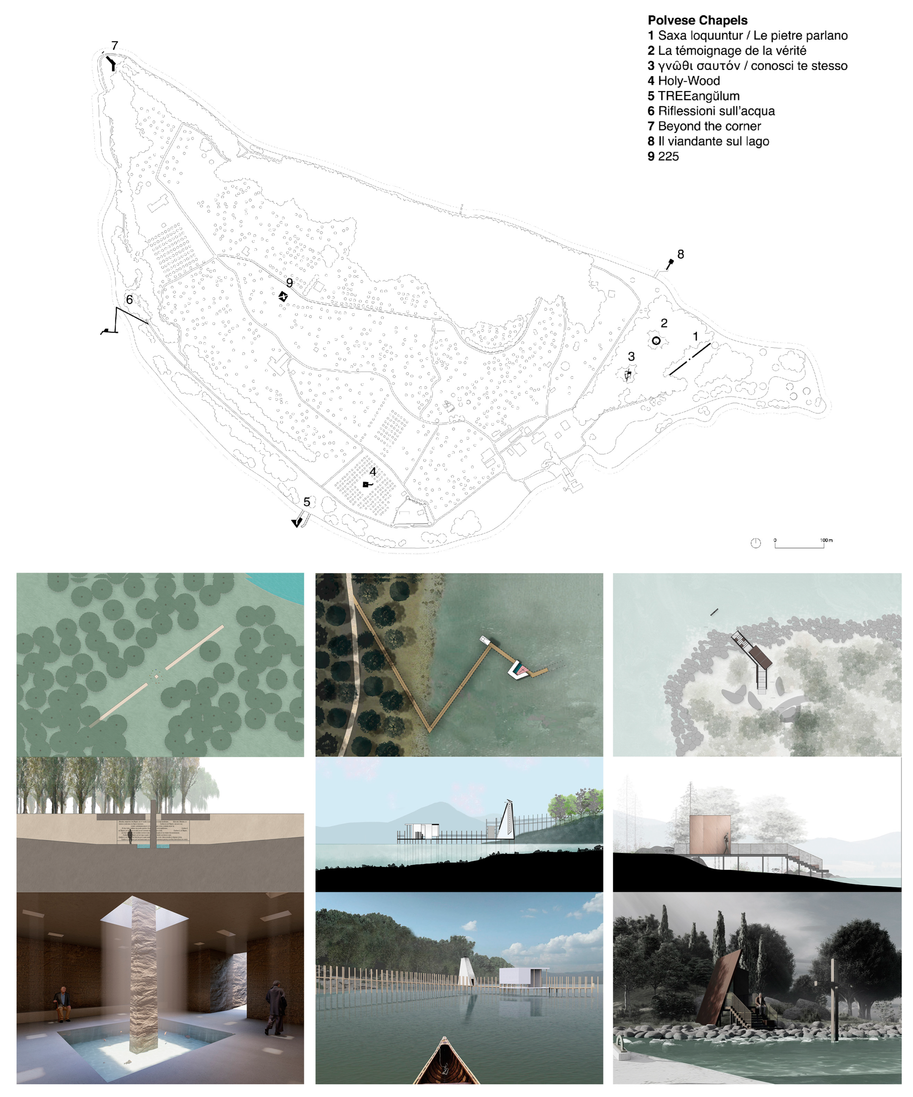
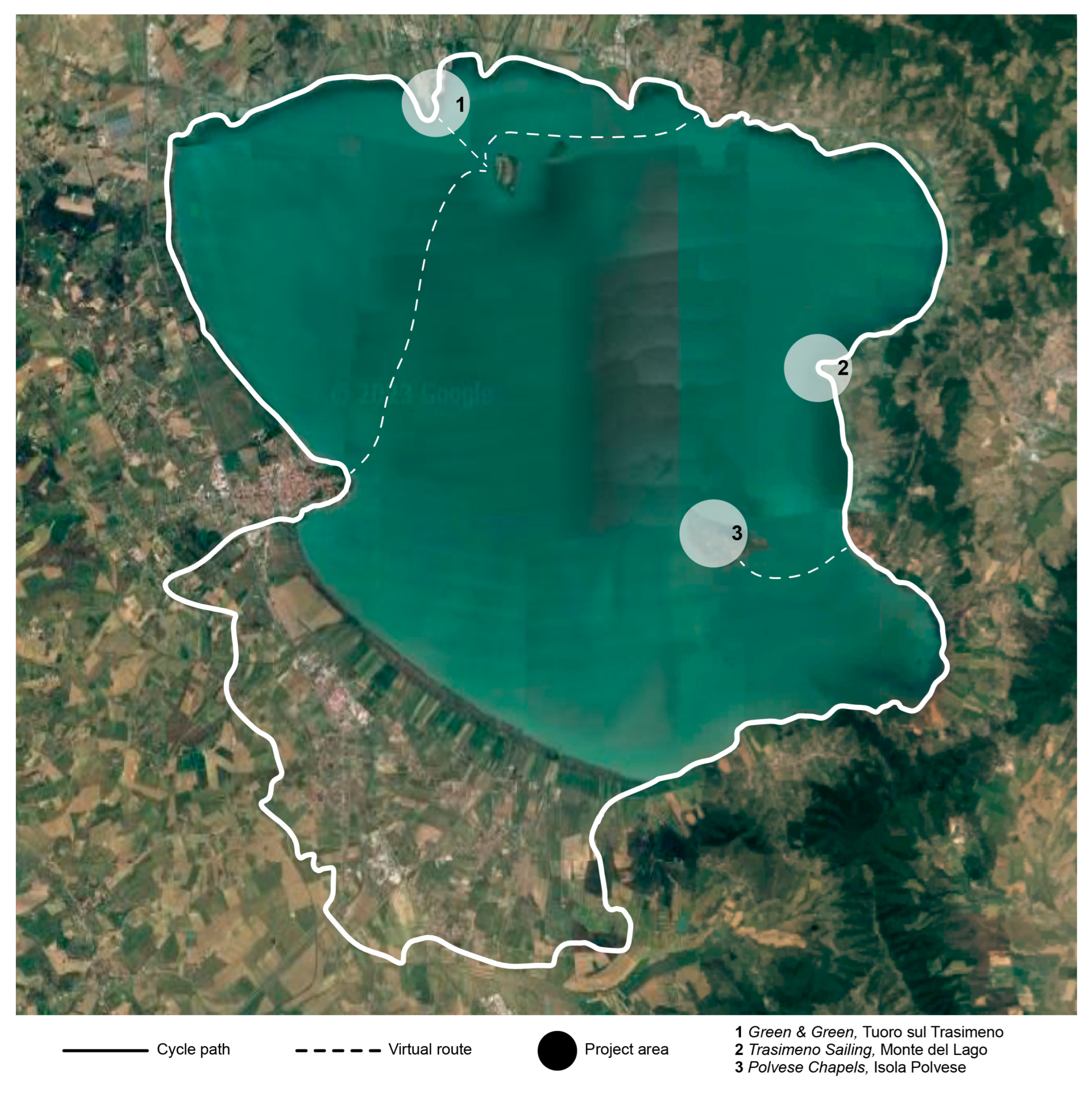
4. Heritage Communication/Experience

Starting from the critical considerations that emerged during the analysis phase, a number of design strategies were experimented with, aimed at enhancing the previously identified aspects of the landscape and proposing innovative ways of fruition, both physical and virtual, of the tangible and intangible cultural heritage of Lake Trasimeno. Within a synergic vision centred on the enhancement of the specific and typical qualities of the Trasimeno area, three specific actions have been identified to promote an aware and sustainable tourism that cannot disregard the knowledge of the peculiarities that make up the landscape itself. The three proposals, all developed by an interdisciplinary team of the Department of Civil and Environmental Engineering of the University of Perugia, are conceived as a possible standstill within the existing outdoor routes, referring both to the cycle path along the coastal strip (identifying two case studies, one in Tuoro sul Trasimeno and one in Monte del Lago) and the virtual route within the lake (identifying the Isola Polvese area as a case study) (Figure 4). The project proposals described below have the common objective of interpreting some of the main aspects of sustainable tourism previously introduced. In fact, three intervention strategies are identified that attempt to combine the economic growth of the territory with the valorisation of local resources and identity. A further important aspect concerns respect for the environment interpreted in relation to seasonality. In fact, in order to avoid an intensive flow of tourists during specific periods of the year and concentrated only on a few areas of the coast, the project proposal identifies a number of project areas equally spread along the coastal strip and intended for diversified functions. This is in order to guarantee a spatially and temporally distributed fruition, but also to offer a diversified quality to the tourist experience.
The Green & Green project, prefigures the architectural and landscape recomposition of Punta Navaccia, an area located in the municipal territory of Tuoro sul Trasimeno and which includes within it a variety of landscapes and facilities: from agricultural areas to fish farms, from the junction of the Perugia-Bettolle motorway to the Foligno-Terontola railway line station, from recreational facilities to the ferry landing stage and from the tourist campsite to the museum park. But it is also an area that, combining many dualities (water and land, silence and noise, the active and the passive), presents a strongly identifiable morphology, marked by a strip of land that, like the prow of a ship, penetrates deep into the lake, blurring the green of the vegetation with the green of the water. Aiming at the valorisation of the pre-existences, the project proposes a cultural theme park in which the planimetric composition is dictated by the textures of the farmland, while the cultural facilities, designed in the form of archaeological finds, are conceived as true works of land art. These are planned to be built with elementary geometries using the land moved for the construction of the new equipped wharf and especially the new dock, which are relocated near the parking areas as well as the railway station to limit private vehicular traffic (Figure 5).
In particular, the Trasimeno Sailing architectural project concerns the functional and figurative reorganisation of the headquarters of the nautical club of the same name, located at the foot of the historic centre of Monte del Lago, a hamlet of Magione, and along the Lake Trasimeno cycle path. A reorganisation based on a series of autonomous but coordinated interventions, such as the restyling of the pre-existing building (which includes a refreshment area, an administrative office and a sheltered area for storage), the preparation of a new body of woodwork to house the essential services (changing rooms and toilets), the setting up of an open-air recreational space (divided into a tree-lined garden towards the lakefront and a floating patio towards the lake), as well as the rearrangement of the dock for mooring the fleet (two rubber dinghies for assistance and four cabin sailboats for educational activities). A long perimeter fence, arranged parallel to the Monte del Lago pier, establishes the boundary between private and public spaces, advertising with the company logo the sporting function housed inside (Figure 6).
Finally, the Polvese Chapels project proposes an immersive sensorial experience that interprets the spiritual dimension of Polvese Island’s natural heritage. Inspired by the Venetian precedent of Vatican Chapels [37], nine naturalistic locations are identified to house as many offline sacred chapels. This is because, at the point of landing on the island, there is a veritable ‘spiritual customs’, equipped with safes where any telematic device must be deposited in order to offer the possibility of regaining a condition of silence and disconnection, even in the crowded tourist environment. On the basis of a unified drawing, three project areas were identified in the willow and poplar forest (located east of the island), a project area in the clearing among the olive trees (located south of the island), three project areas in contact with the water (located, respectively, south-west west and north-east of the island), a project area at the tip, on the border between land and water (located to the north-west of the island) and, lastly, a project area at the top (located at the apex and barycentrically positioned with respect to the island). The project outcomes provide a broad and varied panorama of the different possible meanings of the concept of the spiritual in relation to the naturalistic context of Isola Polvese, identifiable in extraneousness, in the dimension in which it legitimises contemplation through a process of introspective search for solitude (as in the case of the projects Saxa loquuntur/Le pietre parlano, Holy-Wood and 225); in expectation, in the dimension in which the catharsis of meditation is rediscovered (as in the case of the projects Beyond the corner and TREEangŭlum); and in discovery, in the dimension in which the understanding of self and other is stimulated (as in the case of the projects La témoignage de la vérité, γνῶθι σαυτόν/Conosci te stesso, Riflessioni sull’acqua and Il Viandante sul Lago) (Figure 7).

5. Results and Conclusions

The research presented aims to highlight how tourism cannot be an extraneous element of a place’s identity but an element integrated into its social, cultural and economic wealth. From this point of view, it is emphasised that the mapping tool has been fundamental for the analysis phase, providing a critical reading necessary to elaborate the project proposals. However, the need to expand the mapping in order to involve the extension of the entire coastline is highlighted. Likewise, it is expected that the project activity can be further developed, involving also the western side of the coastal perimetre.
The affirmation of sustainable thinking gives value to behaviour whereby tourism does not only refer to a representational image and a visual perception of places but also to a perception related to the other senses [40]. This confirms a performative dynamic of the multiple offers of the tourism system that is essentially linked to the characteristics of the lived travel experience [41]. Within this framework, the research presented attributes of knowledge, representation and critical interpretation of identity landscape aspects an essential active value for the protection and enhancement of cultural heritage.
The restitution and interpretation of the partial mapping presented here show individual perceptions that express the same heterogeneities and contradictions that characterise the territory. It is documented how the multiplicity of factors that have influenced the transformations of the landscape over time have today delineated an extremely complex identity, which offers itself as a palimpsest on which to graft diversified readings of the evolutionary dynamics but which requires advanced tools for management and planning forecasts.
In this sense, the project strategies illustrated take the form of actions aimed at improving the conscious and sustainable use of the Lake Trasimeno landscape, with a view to cultural development as a guarantor of the population’s wellbeing.

Author Contributions

Conceptualization, P.B., V.M. and G.R.; Methodology, P.B., V.M. and G.R.; Writing—original draft, P.B., V.M. and G.R.; Visualization, P.B., V.M. and G.R. All authors have read and agreed to the published version of the manuscript.

Funding

The research activity dedicated to the coastal perimetre of Lake Trasimeno was started within the framework of the Miur 2002 research entitled “Piano di monitoraggio e di riqualificazione delle fasce costiere italiane” (national coordinator, Prof. Roberto de Rubertis, “Sapienza”, University of Rome) and conducted by the research unit activated at the University of Perugia, under the scientific responsibility of Prof. Paolo Belardi.

Institutional Review Board Statement

Not applicable.

Informed Consent Statement

Not applicable.

Data Availability Statement

Publicly available datasets were analyzed in this study. This data can be found here: [siat.regione.umbria.it] (accessed on 11 October 2023).

Acknowledgments

The sensorial mapping presented in the Heritage Mapping/Interpretation section involved a sample of about 30 students, enrolled in the course ‘Architectural Survey’ in the 5-year single degree course in Building Engineering and Architecture at the University of Perugia in the academic year 2022–2023 (lecturer Valeria Menchetelli, subject tutor Francesco Cotana). We would like to thank Francesco Cotana for his collaboration in the conception and scientific setting of the mapping action. The project proposals submitted under Heritage Mapping/Interpretation were drafted between 2016 and 2021 by a working group coordinated by Paolo Belardi. For the Trasimeno Sailing project, we thank, Acqua Dolce Sailing sas, Simone Bori, Matteo Scoccia, Laura Becchetti and Carl Volckerts. For the Green & Green project, we thank Debora Berardi, Alessandro Bulletti, Piergiorgio Manciola and Marco Maovaz. The Polvese Chapels design exercise involved 26 students enrolled in the ‘Architecture and Composition 1′ course in the 5-year single degree course in Building Engineering and Architecture at the University of Perugia in the 2020–2021 academic year. For the supervision activity, we thank Monica Battistoni, Felice Lombardi, Luca Martini, Simone Menichelli, Camilla Sorignani, Margherita Maria Ristori and Luca Tesei.

Conflicts of Interest

The authors declare no conflict of interest.

References

  1. Burzigotti, R.; Capuano, M.C. (Eds.) Zoom Sull’ambiente: L’Isola Polvese; Provincia di Perugia, Assessorato all’Ambiente Area Promozione Risorse Ambientali: Perugia, Italy, 2004. [Google Scholar]
  2. Longo, C.; Salerno, P. Isola Polvese: Itinerari tra Natura, Arte, Cultura; Plestina Società Cooperativa: Perugia, Italy, 2006. [Google Scholar]
  3. Nicoletti, M. Isola Polvese. Territorium egregium. Diomede Riv. Cult. Politica Dell’umbria 2006, 4, 43–50. [Google Scholar]
  4. Pisinicca, E. Vicende Storiche dell’Isola Polvese; Protagon Editrice: Perugia, Italy, 1991. [Google Scholar]
  5. Brandi, C. Umbria Vera; Edizioni Della Cometa: Roma, Italy, 1986. [Google Scholar]
  6. Montella, E. (Ed.) Perugia; Electa Editori Umbri: Perugia, Italy, 1993. [Google Scholar]
  7. Duranti, M. (Ed.) Gerardo Dottori, Opere 1898–1997; EFFE Fabrizio Fabbri Editore: Perugia, Italy, 1997. [Google Scholar]
  8. Flussi Turistici in Umbria Anno 2022. Available online: https://www.regione.umbria.it/turismo-attivita-sportive/statistiche-turismo-2022 (accessed on 20 July 2023).
  9. Strategia Aree Interne 2021–2027. Available online: https://www.regione.umbria.it/strategia-aree-interne-2021-2027 (accessed on 20 July 2023).
  10. PNRR Umbria 2021–2026. Piano Nazionale di Ripresa e Resilienza; Regione Umbria-Giunta Regionale: Perugia, Italy, 2021. [Google Scholar]
  11. Hall, M.; Zeppel, H. Cultural and heritage tourism: The new grand tour. Hist. Environ. 1990, 7, 86–98. [Google Scholar]
  12. Bruscino, A. Il Turismo Sostenibile; Libreriauniversitaria: Padova, Italy, 2021. [Google Scholar]
  13. United Nations. Report of the World Commission on Environment and Development: Our Common Future. 1987. Available online: https://www.unicas.it/media/2732719/Rapporto_Brundtland_1987.pdf (accessed on 20 July 2023).
  14. Clarke, J. A Framework of Approaches to Sustainable Tourism. J. Sustain. Tour. 1997, 5, 224–233. [Google Scholar] [CrossRef]
  15. Messina, S.; Santamato, V.R. (Eds.) Esperienze e Casi di Turismo Sostenibile; Franco Angeli: Milano, Italy, 2012. [Google Scholar]
  16. Contratto di Paesaggio del Trasimeno. Available online: https://www.regione.umbria.it/dettaglionotizie/-/asset_publisher/lU1Y2yh4H8pu/content/contratto-di-paesaggio-del-trasimeno-insediato-tavolo-di-lavoro-interistituzionale?read_more=true (accessed on 20 July 2023).
  17. Osservatorio Regionale per la Qualità del Paesaggio. Available online: http://www.umbriapaesaggio.regione.umbria.it/pagine/piano-paesaggistico-regionale-000 (accessed on 20 July 2023).
  18. Cosgrove, D. (Ed.) Mappings; Reaktion Books: London, UK, 1999. [Google Scholar]
  19. Cosgrove, D. Cultural cartography: Maps and mapping in cultural geography. Ann. Géographie 2008, 660–661, 159–178. [Google Scholar] [CrossRef]
  20. Ganciu, A. Geometric Modelling in the Narrative of Metropolitan Areas: A View on Attraction Dynamics. Diségno 2023, 12, 99–112. [Google Scholar] [CrossRef]
  21. Taylor, D.R.F. Maps and mapping in the information era. In Proceedings of the 18th International Cartographic Conference, Stockholm, Sweden, 23–27 June 1997. [Google Scholar]
  22. Taylor, D.R.F.; Caquard, S. Cybercartography: Maps and Mapping in the Information Era. Cartogr. Int. J. Geogr. Inf. Geovisualization 2006, 41, 1–6. [Google Scholar] [CrossRef]
  23. Diaconu, M. (Ed.) Senses and the City. An Interdisciplinary Approach to Urban Sensescapes; Lit: Vienna, Austria; Berlin, Germany, 2011. [Google Scholar]
  24. Moretti, F.R. La Multimedialità e il Futuro della Cartografia. Available online: https://www.treccani.it/enciclopedia/la-multimedialita-e-il-futuro-della-cartografia_%28XXI-Secolo%29/ (accessed on 20 July 2023).
  25. Cullen, G. Townscape; The Architectural Press: London, UK, 1961. [Google Scholar]
  26. Salerno, R. Mapping Urban Environment by Geometry(es) and Perception(s). In Urban Design and Representation; Piga, B., Salerno, R., Eds.; Springer: Cham, Switzerland, 2017. [Google Scholar] [CrossRef]
  27. Salerno, R. Digital Technologies for “Minor” Cultural Landscapes Knowledge: Sharing Values in Heritage and Tourism Perspec-tive. In Geospatial Intelligence: Concepts, Methodologies, Tools, and Applications; IGI Global: Hershey, PA, USA, 2019; pp. 1645–1670. [Google Scholar] [CrossRef]
  28. Debord, G. Theorie de la derive. Les Lèvres Nues 1956, 9, 6. [Google Scholar]
  29. O’Rourke, K. Psychogeography: A Purposeful Drift through the City. 2021. Available online: https://thereader.mitpress.mit.edu/psychogeography-a-purposeful-drift-through-the-city/ (accessed on 10 September 2023).
  30. Caquard, S.; Griffin, A. Mapping Emotional Cartography. Cartogr. Perspect. 2019, 91, 4–16. [Google Scholar] [CrossRef]
  31. Wartmann, F.M.; Koblet, O.; Purves, R.S. Assessing experienced tranquillity through natural language processing and landscape ecology measures. Landscape Ecol. 2021, 36, 2347–2365. [Google Scholar] [CrossRef] [PubMed]
  32. Nold, C. (Ed.) Emotional Cartography. Technologies of the Self. 2009. Available online: http://www.emotionalcartography.net/ (accessed on 20 July 2023).
  33. Correggiari, M.; Mappe emozionali. Interagire con la Percezione del Paesaggio, Master in World Natural Heritage Management. Available online: https://www.researchgate.net/publication/311807785_Mappe_emozionali_Interagire_con_la_percezione_del_paesaggio_Ricerca_e_idea_progettuale (accessed on 20 July 2023).
  34. Balestrieri, M.; Cicalò, E. Se la rappresentazione si autoavvera. Relazioni di co-evoluzione tra il territorio e la sua immagine. Territorio 2020, 93, 7–12. [Google Scholar]
  35. De Rubertis, R. La Riva Perduta. Piano di Monitoraggio e di Riqualificazione delle Fasce Costiere Italiane; Officina Edizioni: Roma, Italy, 2005. [Google Scholar]
  36. Misharina, A.; Betts, E. The Embodied City: A Method for Multisensory Mapping. In Capturing the Senses. Quantitative Methods in the Humanities and Social Sciences; Landeschi, G., Betts, E., Eds.; Springer: Cham, Switzerland, 2023. [Google Scholar] [CrossRef]
  37. Dal Co, F. (Ed.) Vatican Chapels; Electa: Milano, Italy, 2018. [Google Scholar]
  38. Berardi, D. Progetto di Ricomposizione Architettonica e Paesaggistixa dell’area di Punta Navaccia a Tuoro (PG). Master’s Thesis, Department of Civil and Environmental Engineering, University of Perugia, Perugia, Italy, 2019. [Google Scholar]
  39. Hoflab. Club Nautico. 2016. Available online: http://www.hoflab.it/architetture/regesto/club-nautico (accessed on 20 July 2023).
  40. Pink, S. Sensing Cittàslow: Slow living and the constitution of sensory city. Senses Soc. 2007, 2, 59–77. [Google Scholar] [CrossRef]
  41. Gemini, L. Viaggio. Immaginario, Comunicazione e Pratiche del Turismo Contemporaneo; Franco Angeli: Milano, Italy, 2008. [Google Scholar]
Figure 1. Lake Trasimeno location at national level (left) and regional level (right).
Sustainability 15 14777 g001
Figure 2. Lake Trasimeno coastline analysis, aerial images comparison. Years: 1954–1955, 1977, 1997, 2005, 2014 and 2023.
Sustainability 15 14777 g002
Figure 3. Lake Trasimeno coastline analysis, mapping project (2023).
Sustainability 15 14777 g003
Figure 4. General map of the project areas.
Sustainability 15 14777 g004
Figure 5. Planimetry, front and 3D simulation. Courtesy of Debora Berardi [38].
Sustainability 15 14777 g005aSustainability 15 14777 g005b
Figure 6. Plan, front and 3D simulation. Courtesy of HOFLAB [39].
Sustainability 15 14777 g006
Figure 7. Masterplan and infographic simulation related to the project Polvese Chapels. Courtesy of Alessia Amadei, Letizia Busani, Tommi Hay Greene, Valerio Moretti, Silvia Nafissi, Agata Nardella, Benedetta Romualdi, Chiara Terchi Nocentinij and Maria Virginia Vagni.
Sustainability 15 14777 g007
Disclaimer/Publisher’s Note: The statements, opinions and data contained in all publications are solely those of the individual author(s) and contributor(s) and not of MDPI and/or the editor(s). MDPI and/or the editor(s) disclaim responsibility for any injury to people or property resulting from any ideas, methods, instructions or products referred to in the content.

