1. Introduction
Consolidation of land to improve living and farming conditions in rural areas is a significant and current object of study in various regions of the world. The special importance of land consolidation for sustainable rural development is testified by numerous examples documented in, among other countries, China [
1,
2,
3,
4,
5,
6,
7], India [
8], Czechia, France, Turkey [
9,
10,
11,
12,
13], Albania [
14], Cyprus [
15,
16,
17], Serbia [
18], Slovakia [
19,
20,
21,
22], Slovenia [
23], Estonia [
24], Lithuania [
25], Finland [
26], Croatia [
27] and Poland [
28,
29,
30,
31,
32,
33,
34,
35,
36].
Simultaneously, many researchers mention the urgent necessity of improving land consolidation procedures to improve the efficiency of work and maximise the benefits. The role of land consolidation in sustainable rural development and the possibility of programming works with a particular focus on what the community and environment needs are essential objects of present-day research. Long et al. observe a strong relationship between land consolidation and rural development. However, in response to the effects of the marginalisation of agriculture and rural areas in China for the benefit of industrialisation and urbanisation, the authors elaborated on the idea of comprehensive consolidation considering rural areas as a living space and a strategic resource of the national economy. They recommended the concept as an extension of the existing land consolidation programmes focusing mainly on the technical aspects of optimising the spatial layout of agricultural holdings to increase the efficiency of agricultural production [
37]. Yin et al. suggest similar solutions and give numerous examples of comprehensive land consolidation projects as the key elements of rural land restructuring aimed at noticeable improvements in rural life [
38]. On the example of land consolidation projects in Europe and China, de Vries underlines a distinctive role of social factors in increasing the efficiency and viability of land consolidation projects and postulates that the social aspect should be taken into consideration at all stages of land consolidation, criticising the commonly observed approach based on economic criteria. In the author’s opinion, ensuring the real participation of the population within the consolidated area in the planning and execution of land consolidation projects can contribute to increasing the actual universal efficiency of all operations [
39]. Ettanen and Vitikainen discuss changes to the landscape of the consolidated area based on case studies from Finland. Too much interference with the historical heritage of localities, constituting a potential adverse effect of land consolidation, can give rise to residents’ objections regarding land consolidation works. As regards the urgency of measures for the protection of the natural and cultural values of rural areas, the authors recommend that the specific landscape features of the consolidated area should be taken into account from time to time, and its particularly valuable elements should be incorporated in the design of the new space [
40]. Wang et al. also tackle the problem of potential decline in the biodiversity of consolidated objects as a phenomenon adversely affecting the landscape and the ecosystem in the consolidation area and recommend introducing compensation mechanisms for ecological areas lost due to land consolidation towards intensive agriculture [
41].
Researchers also discuss methods for delimiting sites subject to land consolidation. The optimum selection of land where the spatial layout of agricultural holdings needs adjusting makes it possible to allocate available resources correctly and maximise the productivity of agriculture on a local and national scale. An author undertaking this topic is Leń, presenting a self-designed system for multivariate identification and prioritisation of land consolidation needs. The solution, which is based on the specific features of Polish agriculture, makes it possible to adapt the scope of evaluation criteria to local conditions determining the urgency of land consolidation projects in the study area [
42]. Methods of selecting potential objects for consolidation are also the subject pursued by Janus and Taszakowski. The authors present a tool supporting substantive qualification of individual areas for consolidation and ensuring the possibility of creating urgency rankings for objects in waiting [
43]. In the context of delimiting potential sites for consolidation, it is necessary to take note of consolidation obstacles and identify agricultural wastelands. Wójcik-Leń presented a self-designed method of advanced analysis of so-called problem areas. Accurate specification of the location of adverse factors that are difficult to identify using conventional methods contributes to the correct layout of utilised agricultural areas and non-agricultural areas, and in particular cases, also to revising the legitimacy of land consolidation projects [
33].
The vast research scope also includes various concepts of boosting land consolidation efficiency, understood as the efficiency of performing individual tasks and their effectiveness manifested as improved parameters of the spatial structure of agricultural holdings and the general satisfaction of landowners [
12,
13,
17]. Relying on surveys conducted in Poland, Cienciała et al. promote using dedicated photogrammetry resources as the materials to partially replace time-consuming fieldwork and provide reliable data on land cover, land use, terrain relief and topography. They believe that aerial imagery and digital terrain models acquired by unmanned aerial vehicles can significantly accelerate land consolidation and provide valid data of use at the farmstead design stage [
44]. Teijeiro et al. see the possibility of optimising land consolidation efficiency and effectiveness by introducing genetic algorithms for automated farmstead design. In their opinion, automated computer solutions considerably increase the possibility of fulfilling the assumptions, including optimising plot shapes and layout and considering the individual needs of land consolidation participants [
45]. İnceyol and Özbeyaz and Ertunç et al., authors of artificial intelligence-based algorithms for land consolidation in Turkey [
46,
47], also support this view. Tunalı and Dağdelen compare the efficiency of a numerical land reallocation method based on fuzzy logic with a conventional manual reallocation method based on the consolidation participants’ wish list. The study shows that numerical methods are considerably more efficient [
48]. Uyan et al. formulated similar claims referring to the outcomes of a study comparing present-day heuristic methods such as the spatial decision support system and the genetic algorithm with manual ones [
49].
Implementing innovative solutions for a universal optimisation of the land consolidation and exchange process without a relevant regulatory framework is impossible. The world literature depicts some legal systems in the countries of Central and Eastern Europe as particularly problematic. Anachronous regulations inhibiting the modernisation of the land consolidation procedure are present predominantly in post-socialist states. Their legislation shows a clear impact of the restricted ownership rights, being a relic of the socialist system [
3,
24]. There are also regulation elements regarding the economic transformation, including, without limitation, the re-privatisation of agricultural holdings. Adverse conditions are particularly notable in former Soviet Republics such as Lithuania and Ukraine. Pašakarnis and Maliene highlight the negative consequences of land privatisation in Lithuania that led to excessive land fragmentation. The authors suggest introducing solutions to urgently intensify land consolidation projects [
25]. Martyn et al. point to a necessity to modify the legal system of Ukraine and criticise the diagnosed technical incapacity to coordinate land consolidation works [
50].
The vast thematic scope of research carried out in countries with various specific agricultural features reflects the current need for improving land consolidation methods and implementing solutions to optimise the results of the operations. Since land consolidation is a multifaceted process, and its tasks are complex, a considerable part of these concepts refers to narrow, explicit groups of specialist issues usually associated with respective stages of the land consolidation procedure. Therefore, creating an efficient land consolidation and exchange model requires substantively correct integration of particular concepts and ensuring they are compatible with local law and customary practices. The research presented above focuses on options to optimise land consolidation methods at all stages of the procedure. The researchers recommend tools to minimise the working time and improve the quality of deliverables. A detailed analysis of the available literature showed numerous concepts based on self-designed methods considering various land-value determinants. However, in many cases, land consolidation practices imply the necessity to improve the task performance procedures using existing, commonly acceptable methods regulated by law. The analysis of scientific publications revealed an explicit deficiency of applicable technical solutions that would facilitate the improvement of cadastral data processing for the land valuation of particular farmsteads.
One of the problematic aspects of the land consolidation procedure in Poland is the broadly understood valuation of land, which is carried out in the course of comparative estimates of land value and has essential applications at the stage of designing new farmsteads based on the value of land held by respective existing owners. The present discussion covers, in particular, the consideration of methods referring to the substantive concept of rules applied in estimating land value [
51,
52,
53,
54]. However, the possibility of implementing technical solutions to optimise working time and eliminate the risk of errors is still essential. This refers to, among other issues, the problem of generating and applying so-called land use/soil valuation classes used in computing and design works associated with the valuation of existing farmsteads and redesigning the spatial structure of land [
55].
This paper aims to supplement practical knowledge to the extent mentioned above and provide tools to optimise the performance of this problematic activity. A detailed objective of our research, based on the case study presented in the following section, was the preparation of technical assumptions and practical implementation of the concept of a tool to improve cadastral data processing for land valuation in consolidation projects. An innovative algorithm was designed under these measures, ensuring automated conversion of soil class and land use contours into land use/soil valuation classes necessary for correct land valuation. In addition to the fundamental functions such as geometric intersection and recomputing attribute fields, the algorithm offers an interactive tool for checking the correctness of input data topology and eliminating potential gaps and residual polygons. The solution makes it possible to eliminate time-consuming manual operations and topological errors perpetuated by tools offered with commonly available programmes supporting the graphic layout of cadastral databases. We thoroughly evaluated the solution and then implemented it in the land consolidation work of the Subcarpathian Office of Land Surveying and Agricultural Areas in Rzeszów.
2. Description of the Object of Study
The survey, designing and evaluating an automated tool to support generating land use/soil valuation class geometries, was based on a real land consolidation project in Poland. A simplified procedure for implementing the integral stages of land consolidation, stemming from the provisions of the Act of 26 March 1982 on Land Consolidation and Exchange [
51], consists of the following:
Developing assumptions for the land consolidation project;
Analysing and evaluating available land surveying materials;
Examining land and mortgage registers and checking their consistency with the cadastral register;
Checking the soil classification of land and updating information on land use;
Measuring the invariable elements of the project;
Appraising land value and compiling the land register to date;
Recording the wishes of land consolidation project participants on the desirable location of land;
Preparing and consulting the preliminary plot layout;
Preparing a land consolidation project;
Delimiting and presenting the land project;
Preparing documentation, analysing objections to the land consolidation project and implementing relevant modifications; preparing a draft decision approving the land consolidation project;
Compiling land surveying records and updating information in the cadastral database;
Assigning ownership of new land to consolidation participants and compiling documentation for land and mortgage register updates.
The object of study is, in particular, work stages referring to the control and updates of soil classification of land and land appraisal. These activities require properly processed cadastral data in the form of geometric and database objects representing the so-called land use/soil valuation classes. The specificity of this object stems from the applicable technical and legal solutions as described by regulations on the structure of the cadastre.
In Poland, the Regulation of the Minister of Economic Development, Labour and Technology of 27 July 2021 concerning the Land and Buildings Register defines soil class contours and land use classes as separate classes of objects having their own geometries and standardised attributes. The key designation distinguishing between types of soil class contours is the set of attributes called OZU (soil class contour type) and OZK (soil valuation class), whereas the OFU attribute (land use class type) specifies the type of land use class. At the same time, the above-referenced regulatory act introduces the term “land use/soil valuation class” as a geometric intersection of the layers of soil class contours and land use classes that connects the attributes of designations of such layers [
56]. The value of the area covered by corresponding land use/soil valuation classes is defined by the so-called registered plot surveys, which are numeric descriptions of the nature of the land and constitute, among other things, the primary sources of data for comparative estimates of land value and design of new farmsteads in the land consolidation process.
The concept of land use/soil valuation class as the result of an intersection between layers of soil class contours and land use contours is justified from the point of view of georeferenced database administration. Maintaining separate layers of soil class contours and land use contours allows their independent modification and graphic presentation and facilitates various spatial analyses. Simultaneously, a potentially adverse consequence of documenting soil class contours and land use contours as two separate categories of objects is the absence of a direct visual representation of land use/soil valuation classes, which is significant for the land surveying procedures. Introducing land use/soil valuation classes as additional objects with their own geometries and attributes would result in undesirable redundancy of data, which could give rise to potential substantive errors [
57,
58,
59].
The absence of an independent category of objects representing land use/soil valuation classes is not typically an issue with their correct interpretation using cadastral database management software. Still, some specialised operations such as, in particular, the aforementioned comparative estimates of land value and farmstead design in the course of land consolidation, require prior conversion of existing layers of soil class contours and land use contours into a uniform and spatially continuous layer of land use/soil valuation classes clearly labelled and retaining information contained in the attributes of the constituent layers.
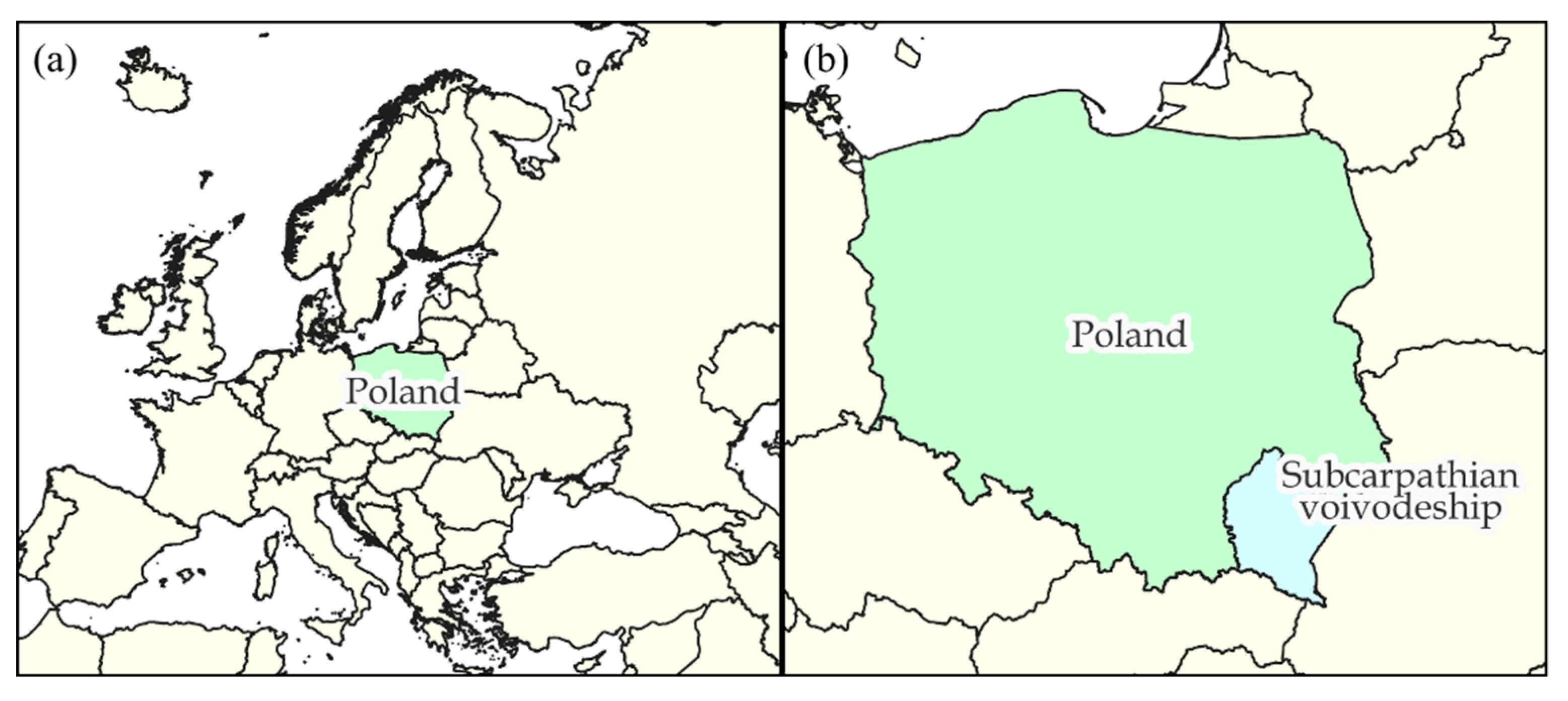
The tool developed within the research procedure was evaluated in detail using cadastral databases from 21 districts of the Subcarpathian voivodeship located in Southeastern Poland (
Figure 1), including localities where land consolidation works are currently pending.
3. Materials and Methods
In line with the concept of the designed tool, to prepare a detailed tool project and then put it into practice and verify the deliverables, elements of district cadastral databases consisting of visual and descriptive data regarding soil class contours and land use contours were retrieved. The retrieved input data were derived from all 21 districts forming the Subcarpathian voivodeship (Southeastern Poland). Since our study focused mainly on rural land, we did not include the area of municipalities (i.e., towns with district rights).
Data files fully or partially representing district cadastral databases in each case covered the vector geometries of soil class contours and land use contours delimiting the spatial range of corresponding land types, as classified by the authorised land surveyor and recorded in the cadastral database with an accuracy specific to the geodetic measurement technique used. The nominal resolution of spatial data supported by software for geometric cadastral data processing was 0.01 m.
Table 1 contains detailed characteristics of the source data used.
In line with the adopted project assumptions, we developed an algorithm that converted the geometric objects of the “soil class contour” and “land use contour” categories into a technical vector layer of land use/soil valuation classes.
Figure 2 presents a general overview of the underlying assumption of the designed tool.
Open-source QGIS provided the software environment for developing and implementing the model of algorithms, making the designed tool accessible and intuitive. The use of existing Python libraries and predefined elementary algorithms for geospatial computing typical of GIS technology contributed to minimising the duration of the design stage and optimising the computing modules. The commonly used SHP (shapefile) format ensured compatibility between data processing formats and existing software.
A nominal set of input data for this algorithm comprises four vector data files, including polygon layers representing soil class contours and land use contours and point layers containing their vertices. The adopted concept stems from technical solutions used in the EWMAPA programme issued by Geobid sp. z o.o. (Katowice, Poland) as the primary environment supporting the graphic layout of the cadastral database for most districts of the Subcarpathian voivodeship. With data from other districts, using TurboMAP by Geomatyka Kraków s.c. (Kraków, Poland), it is possible to generate the point layer of vertices using a suitable geoprocessing tool available in the basic applet in QGIS. In addition, the delimited layers should be accompanied by names of attributes storing information on the unique numbers and dictionary designations of soil class contours and land use contours and the numbers of points representing vertices. A significant element of the input data set is the bilateral instruction defining the algorithm’s operation flow in the case of errors in geometry and attributes due to incorrect input files. Depending on the command checkbox selected by the user, the algorithm can either leave defective objects in the output layer with a suitable warning label or delete incorrect elements, hence reducing the output data set to land use/soil valuation classes compatible with software supporting land consolidation works.
Correct identification of source data previously imported into the QGIS interface makes it possible to launch the generation of output layers of land use/soil valuation classes, including polygons and points representing their vertices.
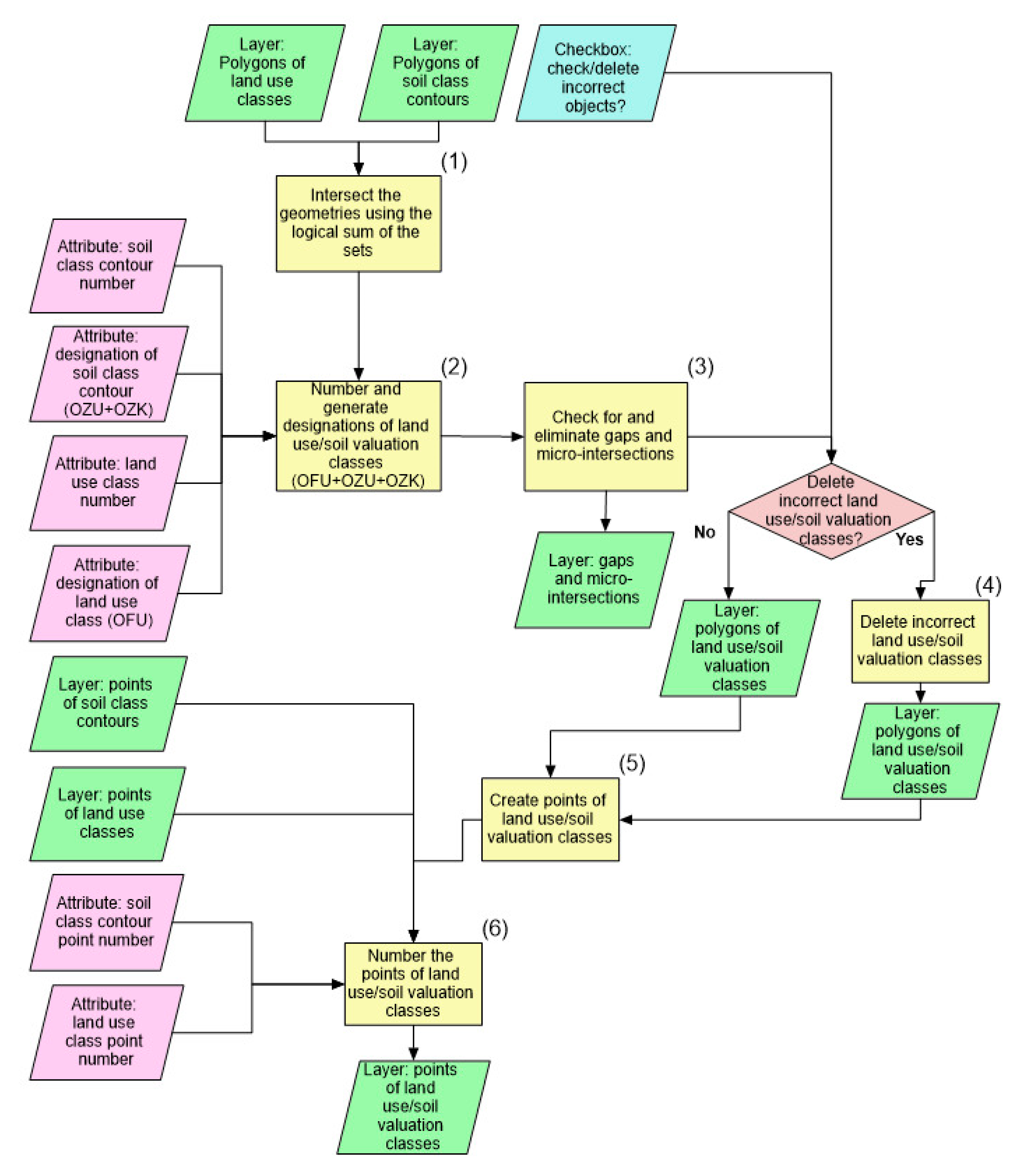
Figure 3 is a general flow chart of the algorithm.
At the first and the key stage of the algorithm’s operation, the geometries of soil class contours and land use contours intersect (1). A basic geoprocessing operation generates the principal layer representing the polygon geometry of land use/soil valuation classes. However, in its ultimate shape, it needs an attribute describing the types of land use/soil valuation classes according to the applicable dictionary values and ensuring a correct geometry of the objects.
As the next operation, the algorithm assigns new, unique numbers to each land use/soil valuation class and generates designations combining OFU, OZU and OZK attributes as the legacy of input layers (2). The rules for creating designations of land use/soil valuation classes are laid down in the Regulation of the Minister of Economic Development, Labour and Technology of 27 July 2021 concerning the Land and Buildings Register [
56]. However, the original guidelines were modified to ensure compatibility between output data and software supporting land consolidation works. The algorithm, relying on SQL queries, searches for OFU, OZU and OZK in the arrays of input layers’ attributes and then merges them and creates the target designation of land use/soil valuation classes based on the following criteria:
A standard designation for a land use/soil valuation class is [OFU]/[OZU][OZK].
For land use classes such as arable land, permanent meadows, permanent pastures and forest and afforested areas, the OFU attribute having the value coinciding with that of [OZU] is not taken into account. This land use/soil valuation class is designated as [OZU][OZK].
For land use classes not included in the classification of soils, the land use/soil valuation class is designated as [OFU].
At the next stage, the tool runs an obligatory check and eliminates micro-surfaces and gaps understood as polygons or empty spaces with a surface area of up to 1 m2 (3). Such errors result from slight inconsistencies in the geometry of soil class contours and land use contours. The algorithm automatically fills the gaps and eliminates micro-surfaces by attaching defective surfaces to adjacent objects. However, it also creates an additional output layer containing point objects at the locations of micro-surfaces or gaps so that the user can verify or possibly correct the existing inconsistencies.
The tool also verifies correctness at the following stage. Having eliminated slight errors in the topology, it checks the land use/soil valuation classes for substantive correctness based on compatibility between their designations and acceptable dictionary designations stemming from a regulatory act [
56] (4). Potential inconsistencies are grave errors that generally prevent the use of output data in further works or pose a risk of perpetuating material inconsistencies in a cadastral database. The presence of defects can testify to one of the following three emergencies regarding the input layers:
Missing or distorted land use contours or soil class contours;
Missing or incorrectly recorded OFU, OZU and OZK attributes;
Inconsistency in the spatial range of layers of land use/soil valuation classes.
Errors trigger one of two emergency procedures selected by the operator before putting the algorithm into operation. Depending on the option selected, the tool may leave incorrect elements in the output layer with a relevant label or delete the defective objects and allow importing output data into cadastral database management software. However, it should be highlighted that using incomplete layers of land use/soil valuation classes in operations, such as comparative estimates of land value or farmstead design, leads to perpetuating critical errors in the database. For correct results, we suggest choosing the option of leaving and labelling incorrect elements in the output layer. This information on the location of errors can be used for adjusting the input layer before subsequent iterations of the algorithm. The error-free polygon layer of land use/soil valuation classes is the tool’s final deliverable.
Another element of the procedure for generating land use/soil valuation classes is the point layer representing the new objects’ vertices (5). The points of land use/soil valuation classes are not included in the cadastral database, yet they are necessary for the correct import and processing of output data by the target software. The points of land use/soil valuation classes are generated by delineating the breakpoints of their contours. Next, according to the pattern embedded in the attributes of input layers, the points are numbered, which is the last data processing stage (6).
4. Results and Discussion
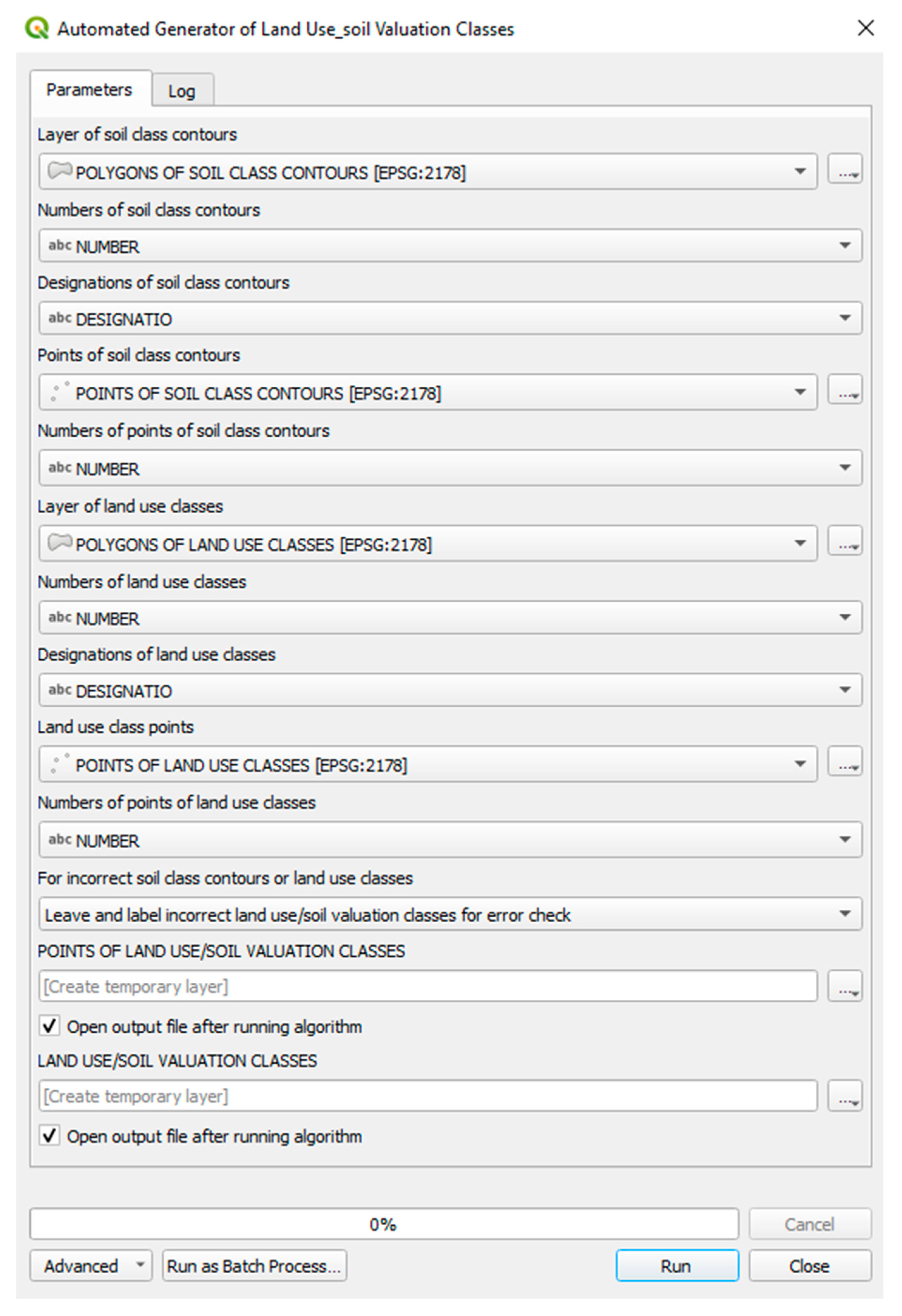
Our work resulted in developing a self-designed algorithm ensuring substantively correct conversion of separate soil class contours and land use contours into unified land use/soil valuation classes used for, among other applications, comparative estimates of land value and designing new farmsteads in the land consolidation procedure. The tool activates fully automated tasks, simultaneously maintaining complete and substantively correct data processing. The intuitive interface of the model (
Figure 4), supported by a popular QIS software environment, makes the tool user-friendly.
The tool’s interface facilitates the free selection of geometric input, including relevant cadastral objects such as soil class contours and land use classes. When determining the attribute fields corresponding to object numbers and designations (OFU, OZU and OZK attributes), the user selects the value from a drop-down list of attributes for respective layers. For input data provided in the applicable GML format, the correct names of attribute fields storing object identifiers and designations are assigned automatically.
The tool was subject to a detailed evaluation using vast sets of cadastral data derived from 21 districts of the Subcarpathian voivodeship to verify the correctness and efficiency of the underlying solutions. Especially valuable is the analysis of the algorithm’s path taken with incomplete or defective sets of output data. In addition, we investigated the substantive correctness of designations assigned to land use/soil valuation classes and compatibility between output data and numeric cadastral database management software. The outcomes supported the view that the algorithm is a safe and effective tool capable of fully accomplishing the adopted assumptions.
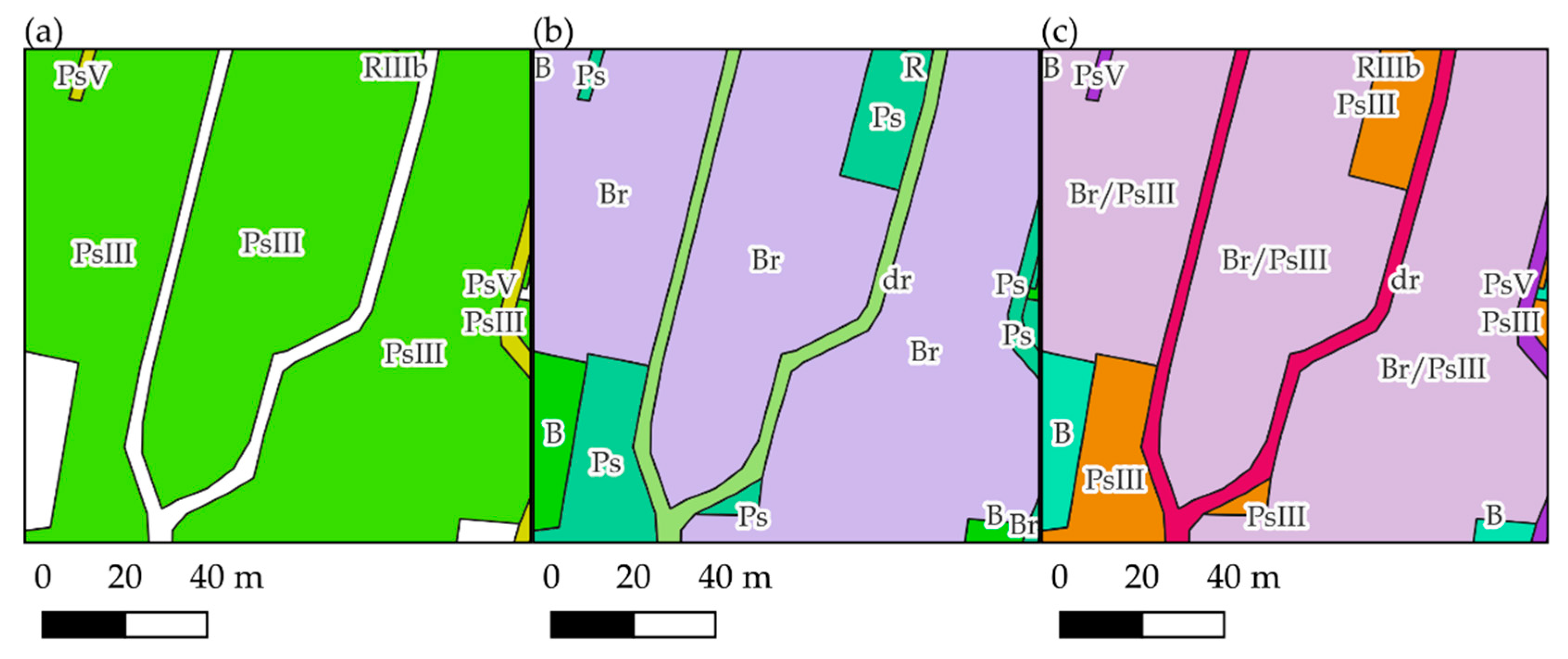
Test results illustrating how the algorithm works and specifying output data are described below using representative examples of the villages of Grodzisko Górne (Leżajsk district) and Turze Pole (Brzozów district).
Figure 5 presents them as final vector layers of land use/soil valuation classes.
The result illustrates a substantively correct cadastral data conversion procedure. The output objects shown in the figure are typical examples of land use/soil valuation classes used, for instance, in estimating land value. Automatically generated designations determining land use/soil valuation class types comply with the rules set out by the legal regulations in force and referred to in
Section 2.
The module for preliminary quality control of input data was also subject to critical evaluation. To verify the solution’s efficiency, we entered input objects with incorrect topology, containing gaps or overlapping areas, into the tool’s interface.
Figure 6 shows an example result for a cadastral database covering the village of Turze Pole.
The applied control procedure demonstrated inconsistencies leading to output data discontinuity. This phenomenon necessitates verifying and adjusting input data (soil class contours or land use contours) at locations designated by automatically generated tags. The probable cause of an error presented above can be the lack of necessary coverage between the corresponding vertices of soil class contours and land use contours. The correct identification of inconsistencies in the geometry of input data was additionally confirmed by an independent analysis using EWMAPA software, the outcome of which—referring to the same area—is presented in
Figure 7.
A significant benefit attached to the developed model, corroborated by the evaluation, is the ability to smoothly eliminate all inconsistencies in the geometry and attribute designations, which are a relatively common defect of cadastral inputs. The implemented control and repair modules have eliminated the need for manual verification of substantive correctness—a considerably more labour-consuming task associated with an unacceptable risk of perpetuating critical errors. The absence of analogical solutions in the existing software supporting the graphic layout of cadastral databases is the main reason for developing and using this algorithm. Other advantages of this tool include seamless editing of the source code in the Python script corresponding to the algorithm model of QGIS. Changes, if any, may be required, for instance, in the case of an obligatory change of methods used in creating designations of land use/soil valuation classes or dictionary values of soil class contour and land use contour designations due to modification of legal regulations in force.
We have used the tool in land surveying practice at the Subcarpathian Office of Land Surveying and Agricultural Areas in Rzeszów—an entity authorised to conduct land consolidation and exchange works within the Subcarpathian voivodeship. The proposed solutions have considerably reduced the processing time of data necessary for key operations such as comparative estimates of land value and designing farmsteads based on the estimated value of land use/soil valuation classes. The improvement offers an additional benefit, that is, full correctness of output data being the condition of substantive correctness of the whole land consolidation procedure.
The tool is universal. The designed algorithm considers the specificity of land consolidation projects in Poland. Still, due to its modular structure, the tool can be adapted to the standards of other cadastral systems.
However, to ensure the tool works correctly, its constraints, particularly those associated with input data quality, should be considered. Despite the module for controlling input data correctness being highly efficient, a risk exists that the errors become permanent if the recommended procedure for using the algorithm is not followed. The mechanism for the preliminary validation of processed cadastral data does not provide solutions that allow us to detect incorrect values of attributes of soil class contours and land use contours if the combination standing for the land use/soil valuation class type falls within the set of acceptable dictionary values. Thus, automated data processing does not preclude the necessity for fulfilling the condition set by the input materials.
A tool that enables the automatic extraction of complete data for land valuation purposes is a practical complement to the land consolidation methodology being analysed and developed. Methods based on the score or monetary value of respective land types, practised over a large area of Poland, require an efficient and uniform system for developing input objects representing the basic land category units in line with the national real estate property register regulations. Dudzińska’s findings have corroborated the advisability of using land use/soil valuation classes that define land use form and soil quality class, constituting the final product of the algorithm in question. She points out that soil quality, as defined by land use types and soil classes, affects the value of land estimated during land consolidation projects to the greatest extent [
60].
Paciorek and Witkowski, in presenting the outcomes of their analysis of land valuation methods used in land consolidation, point to the lack of uniform standards and highlight the relationship between the adopted strategy and factors such as the experience and expertise of the land surveying designer responsible for the land value estimation project [
61]. We believe the observed phenomenon should be considered unfavourable due to the lack of reliable instruments to verify the correctness of actions and the high risk of errors and inconsistencies. The proposed algorithm is an element of efforts to solve this problem by unifying land value calculation methods, which aim to automate the procedures performed.
5. Conclusions
The key driving force of global technological progress is the unlimited requirement for solutions to long-time problems and satisfying the newly emerging needs of human civilisation. As a multifaceted project, the consolidation of land, a procedure significant to the sustainable development of agriculture, requires current expertise and efficient technical solutions based on today’s technological developments. Thanks to efficient geoinformation tools optimising the time and quality of the works, the procedures can be adjusted to the incremental challenges of the present times.
The presented self-designed algorithm for processing spatial data has had practical applications in optimising specific processes that comprise the land consolidation procedure. The use of contemporary developments in GIS technology allowed us to develop a highly efficient tool capable of eliminating potential errors. The replacement of manual or partly automated operations with a unified and intuitive algorithm providing complete automation of the works has had an actual impact on the time and quality of the numerous land consolidation procedures in Southeast Poland. A significant advantage of the proposed tool is its compatibility with legal norms determining land consolidation methodology and the general procedure for performing particular tasks. A considerable part of solutions documented in the world literature is based on the assumptions of existing regulations that need modification to include the concepts we suggested. Due to technical difficulties and the lack of economic justification for such changes, authorities and entities in charge of land consolidation can reject the proposed numerous innovative methods for improving the work.
The result of our research and design activities, substantiated by the needs described in the reviewed literature and the successful implementation of the proposed solutions in land surveying, confirm the commonly proposed necessity for undertaking measures to develop information technology services for the benefit of the broadly understood civilisational progress.


 ,
, 


