
Land- and Skyscapes of the Camino de Santiago: An Astronomy and World Heritage Sustainable Approach


Abstract
:1. Introduction: The Road of the Stars
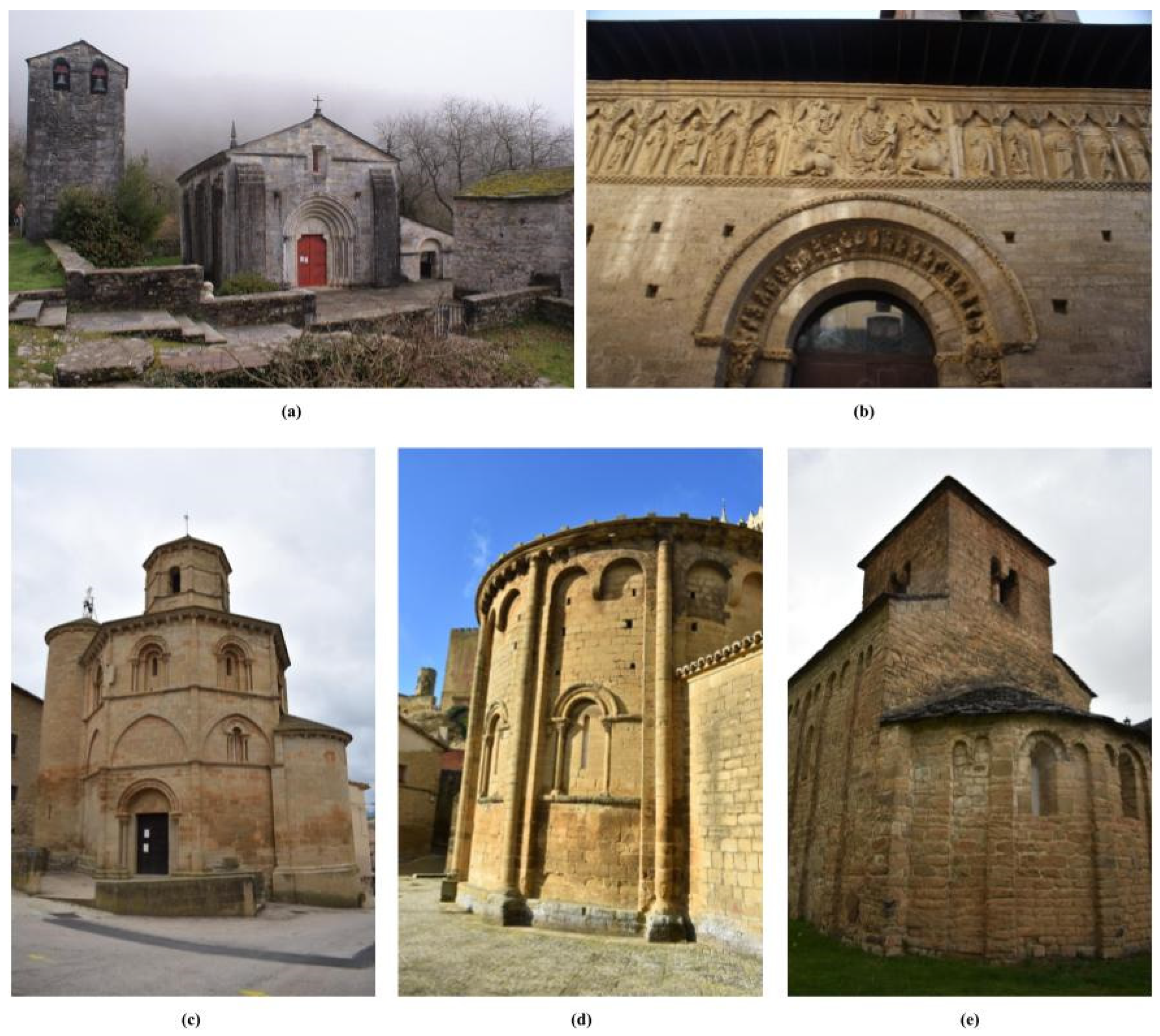
2. Elements in the Landscape: The Orientation of Christian Churches in the Iberian Peninsula
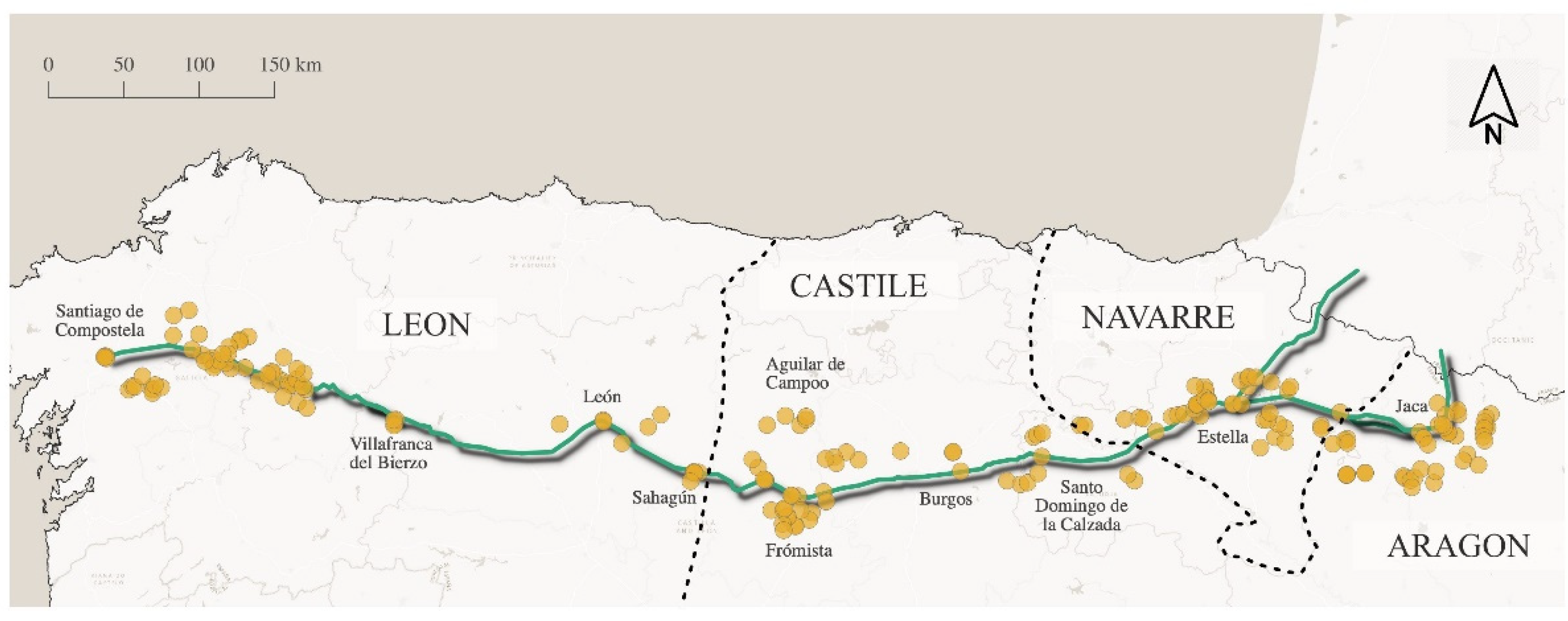
3. Methods
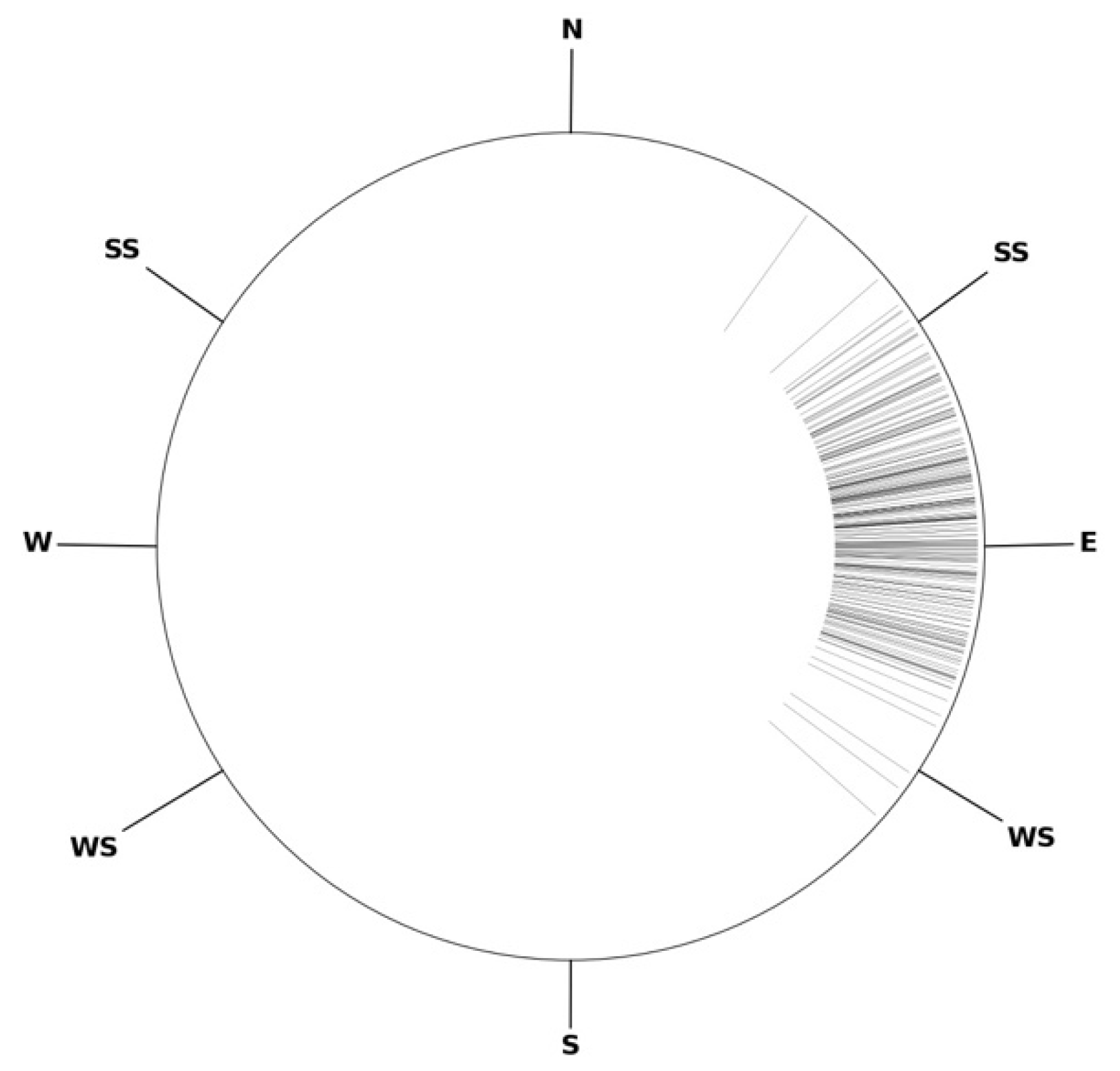
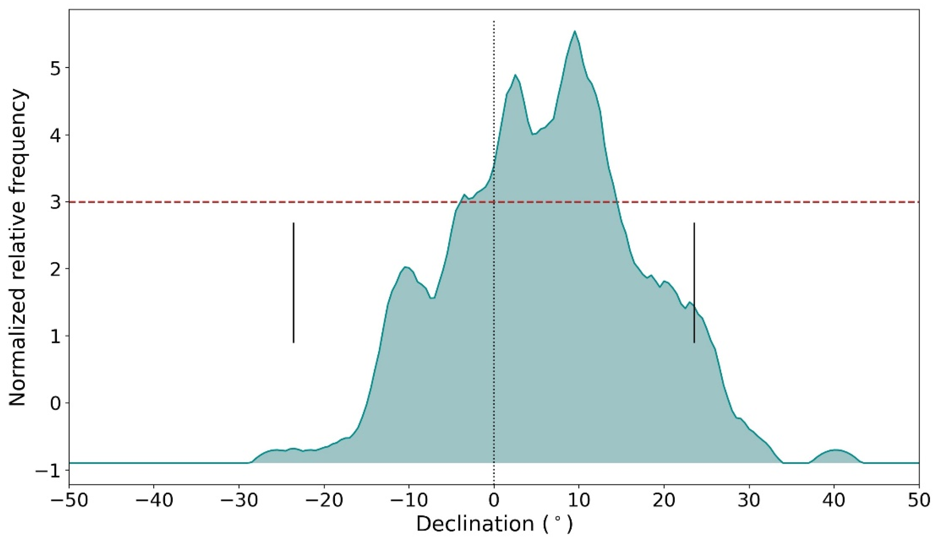
4. Results
5. Discussion
5.1. Leon
5.2. Castile
5.3. Navarre
5.4. Aragon
5.5. The Way
6. Conclusions
Author Contributions
Funding
Institutional Review Board Statement
Informed Consent Statement
Data Availability Statement
Acknowledgments
Conflicts of Interest
Appendix A
| Kingdom | Place | Monument | φ (°/’) | λ (°/’) | a (°) | h (°) | δ (°) |
| Castile (La Rioja) | San Vicente del Valle | Ntra Sra de la Asunción | 42/20 | −3/9 | 62.1 ± 1.1 | 11.5 | 28.2 ± 1.0 |
| Valgañón | Ntra Sra de las Tres Fuentes | 42/19 | −3/4 | 66.8 ± 0.5 | 0.0 | 16.5 ± 0.5 | |
| Zorraquín | San Esteban | 42/19 | −3/2 | 91.5 ± 1.4 | 4.5 * | 1.8 ± 1.2 | |
| Ojacastro | Ermita de la Ascensión San Asensio de los Cantos | 42/22 | −2/58 | 85.7 ± 0.8 | 17.7 * | 14.9 ± 0.7 | |
| Santo Domingo de la Calzada | El Salvador | 42/26 | −2/57 | 95.1 ± 0.4 | 0.3 * | −3.9 ± 0.5 | |
| Ochánduri | Santa María de la Concepción | 42/31 | −3/0 | 54.5 ± 0.5 | 0.5 | 25.4 ± 0.5 | |
| Cuzcurrita del Río Tirón | Santa María de Sorejana | 42/32 | −2/58 | 73.7 ± 0.4 | 1.0 | 12.3 ± 0.5 | |
| Tirgo | San Salvador | 42/32 | −2/56 | 85.8 ± 0.9 | 0.4 * | 3.0 ± 0.8 | |
| San Vicente de la Sonsierra | Santa María de la Piscina | 42/34 | −2/43 | 80.4 ± 0.6 | 3.5 | 9.3 ± 0.6 | |
| Ábalos | San Felices | 42/34 | −2/41 | 83.1 ± 0.3 | −0.5 | 4.3 ± 0.4 | |
| Leza del Río Leza | Santa María de Plano | 42/20 | −2/23 | 79.8 ± 1.1 | 2.5 | 9.0 ± 1.0 | |
| Albelda de Iregua | Santa Fe de Palazuelos | 42/21 | −2/26 | 71.2 ± 0.3 | 1.5 | 14.6 ± 0.4 | |
| Navarre | La Población de Meano | Ntra Sra de la Asunción | 42/36 | −2/27 | 62.4 ± 0.3 | 1.5 | 20.8 ± 0.4 |
| Aguilar de Codés | San Bartolomé | 42/36 | −2/22 | 101.4 ± 0.8 | 7.5 | −3.3 ± 0.7 | |
| Azuelo | San Jorge | 42/36 | −2/20 | 91.1 ± 0.5 | 2.0 | 0.3 ± 0.5 | |
| Torres del Río | Santo Sepulcro | 42/33 | −2/16 | 54.7 ± 0.6 | 7.0 | 30.2 ± 0.6 | |
| Learza | San Andrés | 42/36 | −2/10 | 83.1 ± 0.8 | 2.0 | 6.2 ± 0.8 | |
| Olejua | Santiago | 42/37 | −2/8 | 67.2 ± 1.0 | 5.5 | 20.3 ± 0.9 | |
| Villamayor de Monjardín | San Andrés Apóstol | 42/37 | −2/6 | 88.3 ± 1.0 | 4.0 | 3.8 ± 0.9 | |
| Irache | Santa María de Irache | 42/39 | −2/2 | 89.5 ± 0.8 | 1.0 | 0.8 ± 0.8 | |
| Aberin | San Juan Bautista | 42/37 | −2/0 | 85.1 ± 0.6 | 0.5 | 3.6 ± 0.6 | |
| Estella | San Pedro | 42/40 | −2/1 | 91.3 ± 2.2 | 2.3 * | 0.4 ± 1.8 | |
| Estella | Santa María Jus del Castillo | 42/40 | −2/1 | 77.5 ± 0.5 | 4.1 * | 11.8 ± 0.5 | |
| Estella | Santo Sepulcro | 42/40 | −2/1 | 95.9 ± 1.1 | 6.3 * | −0.1 ± 1.0 | |
| Estella | San Miguel | 42/40 | −2/1 | 89.1 ± 1.1 | 4.5 | 3.6 ± 1.0 | |
| Azcona | Santa Catalina de Alejandría | 42/44 | −1/58 | 71.0 ± 0.6 | 1.0 | 14.2 ± 0.6 | |
| Ugar | San Martín | 42/43 | −1/58 | 89.6 ± 0.5 | 3.3 * | 2.4 ± 0.5 | |
| Zurucuáin | San Martín de Montalbán | 42/42 | −1/58 | 114.6 ± 0.6 | 2.0 | −16.6 ± 0.6 | |
| Eguiarte | Santa María | 42/41 | −1/57 | 91.0 ± 0.6 | 3.0 | 1.1 ± 0.6 | |
| Lácar | Santa Engracia | 42/41 | −1/57 | 64.8 ± 0.5 | 4.1 * | 21.0 ± 0.5 | |
| Puente de la Reina | Santiago | 42/40 | −1/48 | 76.5 ± 0.3 | 1.8 * | 10.9 ± 0.4 | |
| Puente de la Reina | Crucifijo | 42/40 | −1/48 | 65.8 ± 0.9 | 2.2 * | 18.9 ± 0.8 | |
| Muruzábal | Santa María de Eunate | 42/40 | −1/45 | 105.1 ± 0.5 | 2.0 | −9.9 ± 0.5 | |
| Olite | San Pedro | 42/28 | −1/38 | 88.5 ± 1.7 | 1.0 | 1.5 ± 1.4 | |
| Unx | San Martín | 42/31 | −1/33 | 76.1 ± 1.0 | 2.7 * | 11.9 ± 0.9 | |
| Ujué | Santa María | 42/30 | −1/29 | 90.3 ± 1.3 | 0.3 * | −0.4 ± 1.1 | |
| Lerga | San Martín | 42/33 | −1/30 | 77.3 ± 0.4 | 2.3 * | 10.7 ± 0.5 | |
| Olleta | Ntra Sra de la Asunción de la Virgen | 42/35 | −1/32 | 100.6 ± 0.7 | 7.4 * | –2.8 ± 0.7 | |
| Garínoain | Santo Cristo de Catalán | 42/36 | −1/37 | 79.6 ± 0.4 | 4.0 | 10.2 ± 0.5 | |
| Orísoain | San Martín | 42/36 | −1/36 | 85.9 ± 0.8 | 6.5 | 7.3 ± 0.8 | |
| Olóriz | San Pedro ad Vincula de Echano | 42/38 | −1/35 | 61.7 ± 0.5 | 9.5 | 27.1 ± 0.5 | |
| Zariquiegui | San Andrés | 42/44 | −1/43 | 71.1 ± 0.5 | 0.5 | 13.8 ± 0.5 | |
| Larraya | San Román | 42/46 | −1/45 | 75.3 ± 0.6 | 2.0 | 11.9 ± 0.6 | |
| Sagüés | San Miguel Arcángel | 42/47 | −1/43 | 80.1 ± 0.5 | 1.0 | 7.7 ± 0.5 | |
| Gazólaz | Ntra Sra de la Purificación | 42/47 | −1/43 | 75.3 ± 0.6 | 3.5 * | 13.0 ± 0.6 | |
| Cizur Menor | San Emeterio y San Celedonio | 42/47 | −1/40 | 94.7 ± 1.0 | 1.5 | −2.7 ± 0.9 | |
| Zolina | San Esteban | 42/46 | −1/35 | 73.3 ± 0.6 | 3.0 | 14.1 ± 0.6 | |
| Najurieta | Santo Tomás | 42/43 | −1/29 | 69.2 ± 0.5 | 6.0 | 19.2 ± 0.5 | |
| Artaiz | San Martín de Artaiz | 42/44 | −1/28 | 89.5 ± 0.8 | 1.0 | 0.8 ± 0.8 | |
| Sangüesa | Santa María la Real | 42/34 | −1/17 | 93.8 ± 0.5 | 2.9 * | −1.0 ± 0.5 | |
| Vadoluengo | San Adrián | 42/33 | −1/17 | 102.8 ± 0.6 | 1.5 | −8.6 ± 0.6 | |
| Yesa | San Salvador de Leyre | 42/38 | −1/10 | 90.3 ± 0.4 | 0.7 * | −0.1 ± 0.5 | |
| Aragon | Sasabe | San Adrián | 42/40 | −0/35 | 93.5 ± 0.5 | 17.0 | 8.9 ± 0.5 |
| Acín | San Juan Bautista | 42/37 | −0/27 | 83.2 ± 0.4 | 16.0 | 15.7 ± 0.5 | |
| Iguácel | Santa María | 42/38 | −0/28 | 79.8 ± 0.4 | 17.75 | 19.3 ± 0.5 | |
| Castiello de Jaca | Santa Juliana | 42/37 | −0/32 | 65.5 ± 0.7 | 8.5 | 23.6 ± 0.7 | |
| Navasa | Santa Eulalia | 42/31 | −0/28 | 110.5 ± 0.5 | 3.5 * | −12.6 ± 0.5 | |
| Barós | Santiago | 42/32 | −0/31 | 85.7 ± 0.8 | 1.5 | 3.9 ± 0.8 | |
| Barós | San Fructuoso | 42/32 | −0/31 | 104.8 ± 0.8 | 1.5 | −10.1 ± 0.8 | |
| Jaca | San Pedro | 42/34 | −0/32 | 94.1 ± 0.3 | 1.6 * | −2.2 ± 0.4 | |
| Binacua | Ángeles Custodios | 42/32 | −0/41 | 97.7 ± 0.4 | 2.5 | −4.1 ± 0.5 | |
| Santa Cruz de la Serós | San Caprasio | 42/31 | −0/40 | 105.9 ± 0.4 | 10.5 | −4.4 ± 0.5 | |
| Santa Cruz de la Serós | Santa María | 42/31 | −0/40 | 103.4 ± 0.7 | 11.5 | –1.9 ± 0.7 | |
| Botaya | San Miguel | 42/29 | −0/38 | 92.9 ± 1.1 | 13.0 | 6.6 ± 1.0 | |
| Banaguás | San Juan Bautista | 42/34 | −0/35 | 99.8 ± 0.3 | 2.0 | −6.0 ± 0.4 | |
| Asieso | San Andrés | 42/34 | −0/33 | 80.2 ± 0.2 | 4.0 | 9.8 ± 0.3 | |
| Loarre | San Pedro | 42/19 | −0/36 | 83.6 ± 0.7 | 5.5 * | 8.3 ± 0.7 | |
| Loarre | Santa María de Valverde | 42/19 | −0/36 | 83.5 ± 0.7 | 5.5 * | 8.4 ± 0.7 | |
| Agüero | San Salvador | 42/21 | −0/47 | 91.9 ± 0.7 | 4.0 | 1.2 ± 0.7 | |
| Agüero | Santiago | 42/20 | −0/47 | 109.1 ± 3.8 | 1.5 | −13.2 ± 2.9 | |
| Murillo de Gállego | San Salvador | 42/20 | −0/45 | 93.9 ± 0.4 | 7.5 * | 2.1 ± 0.5 | |
| Riglos | San Martín | 42/20 | −0/43 | 105.1 ± 0.9 | 12.0 | −2.8 ± 0.8 | |
| Concilio | Santa María | 42/18 | −0/44 | 100.4 ± 0.5 | 5.0 | −4.4 ± 0.5 | |
| Uncastillo | San Juan | 42/21 | −1/8 | 83.2 ± 0.6 | 5.0 | 8.3 ± 0.6 | |
| Uncastillo | San Martín | 42/21 | −1/7 | 103.4 ± 0.5 | 7.5 | −4.8 ± 0.5 | |
| Uncastillo | Santa María la Mayor | 42/21 | −1/7 | 73.3 ± 0.4 | 6.4 * | 16.5 ± 0.5 | |
| Uncastillo | San Felices | 42/21 | −1/8 | 102.8 ± 0.3 | 5.1 * | −6.0 ± 0.4 | |
| Luesia | San Salvador | 42/22 | −1/1 | 101.4 ± 0.9 | 3.4 * | −6.2 ± 0.8 | |
| Luesia | San Esteban | 42/22 | −1/1 | 80.5 ± 0.2 | 5.0 | 10.3 ± 0.3 | |
| Urriés | San Esteban | 42/31 | −1/7 | 98.7 ± 0.7 | 4.2 * | −3.7 ± 0.7 | |
| Navardún | Ntra Sra de la Asunción | 42/30 | −1/8 | 94.3 ± 0.5 | 3.4 * | −1.0 ± 0.5 | |
| Sos–Ceñito | San Nicolás | 42/30 | −1/7 | 83.2 ± 0.5 | 3.5 | 7.2 ± 0.5 | |
| Sos del Rey Católico | San Esteban | 42/29 | −1/12 | 102.4 ± 0.3 | 1.0 | −8.7 ± 0.4 |
References
- Routes of Santiago de Compostela: Camino Francés and Routes of Northern Spain (UNESCO, World Heritage List). Available online: https://whc.unesco.org/en/list/669 (accessed on 25 November 2021).
- Bango Torviso, I.G. El Camino de Santiago, 1st ed.; Espasa Calpe: Madrid, Spain, 1993; pp. 97–98. [Google Scholar]
- González, R.C.L.; López, L. El Camino de Santiago: Una aproximación a su carácter polisémico desde la geografía cultural y el turismo. Doc. D’anàlisi Geogràfica 2012, 58, 459–479. [Google Scholar] [CrossRef] [Green Version]
- López, L. El Poder Religioso en el Paisaje Europeo Occidental. AGALI J. J. Soc. Sci. Humanit. 2012, 2, 59–75. [Google Scholar]
- Melczer, W. The Pilgrim’s Guide to Santiago de Compostela; Italica Press: New York, NY, USA, 1993. [Google Scholar]
- Falqué Rey, E. Historia Compostelana; Ediciones Akal: Madrid, Spain, 1994; pp. 69–77. [Google Scholar]
- Solana de Quesada, A. Criterios de verosimilitud de la tradición jacobea. Rudesindus 2011, 7, 31–76. [Google Scholar]
- López Alsina, F. La invención del sepulcro de Santiago y la difusión del culto jacobeo. In El Camino de Santiago y la Articulación del Espacio Hispánico (Actas de la XX Semana de Estudios Medievales de Estella. 26–30 de Julio de 1993); Gobierno de Navarra: Pamplona, Spain, 1994; pp. 59–84. [Google Scholar]
- Herbers, K.; Santos Noia, M.; Moralejo, A.; Torres, C.; Feo, J. Liber Sancti Jaobi “Codex Calixtinus”, Libro IV.; Xunta de Galicia: Galicia, Spain, 2001; pp. 13–14. [Google Scholar]
- Belmonte Avilés, J.A.; Sanz de Lara Barrios, M. El Cielo de los Magos: Tiempo Astronómico y Meteorológico en la Cultura Tradicional del Campesinado Canario, 2nd ed.; Le Canarien ediciones: Santa Cruz de Tenerife, Spain, 2020. [Google Scholar]
- International Astronomical Union. Heritage Sites of Astronomy and Archaeoastronomy in the Context of the UNESCO World Heritage Convention: Thematic Study no. 2; Ruggles, C.L.N., Ed.; ICOMOS-IAU: Paris, France, 2017. [Google Scholar]
- Category of Astronomical Heritage: Tangible Immovable ‘Risco Caído and the Sacred Mountains of Gran Canaria’. Available online: https://www3.astronomicalheritage.net/index.php/show-entity?identity=77&idsubentity=1 (accessed on 25 November 2021).
- Hoskin, M. Temples, Tombs and Their Orientations; Ocarina Books: Bognor Regis, UK, 2001. [Google Scholar]
- Esteban, C. Astronomy and Ritual in the protohistory of the Southeast of the Iberian Peninsula. Mediterr. Archaeol. Archaeom. 2018, 18, 33–41. [Google Scholar] [CrossRef]
- Garcia Quintela, M.V.; González-García, A.C. Archaeological Footprints of the “Celtic Calendar”? JSA 2017, 3, 49–78. [Google Scholar] [CrossRef]
- Rodríguez-Antón, A. Cosmovisión y Urbanismo en la Roma Antigua: Orientación de Ciudades y Campamentos Romanos. Ph.D. Thesis, Universidad de La Laguna, Santa Cruz de Tenerife, Spain, 2017. [Google Scholar]
- Rodríguez-Antón, A.; González-García, A.C.; Belmonte, J.A. Astronomy in Roman Urbanism: A Statistical Analysis of the Orientation of Roman Towns in the Iberian Peninsula. J. Hist. Astron. 2018, 49, 363–387. [Google Scholar] [CrossRef]
- González-García, A.C.; Belmonte, J.A. The Orientation of Pre-Romanesque Churches in the Iberian Peninsula. Nexus Netw. J. 2015, 17, 353–377. [Google Scholar] [CrossRef] [Green Version]
- Belmonte Avilés, J.A.; Hoskin, M.A. Reflejo del Cosmos: Atlas de Arqueoastronomía en el Mediterráneo Antiguo; Equipo Sirius: Madrid, Spain, 2002. [Google Scholar]
- Belmonte, J.A. Archaeoastronomy/Cultural Astronomy. OREP 2021, 1–28. [Google Scholar] [CrossRef]
- González-García, C.A.; Belmonte, J.A. Archaeoastronomy: A Sustainable Way to Grasp the Skylore of Past Societies. Sustainability 2019, 11, 2240. [Google Scholar] [CrossRef] [Green Version]
- Ruggles, C.L.N. Handbook of Archaeoastronomy and Ethnoastronomy; Springer: New York, NY, USA, 2015. [Google Scholar] [CrossRef]
- Magli, G. Archaeoastronomy, 1st ed.; Springer: New York, NY, USA, 2016. [Google Scholar] [CrossRef]
- Lockyer, J.N. The Dawn of Astronomy: A Study of the Temple-Worship and Mythology of the Ancient Egyptians; Macmillan and Co.: New York, NY, USA, 1894; pp. 95–98. [Google Scholar]
- Nissen, H. Orientation: Studien zur Geschichte der Religion; Weidmann: Berlin, Germany, 1906. [Google Scholar]
- McCluskey, S.C. Astronomies and Cultures in Early Medieval Europe; Cambridge University Press: Cambridge, UK, 1998. [Google Scholar]
- McCluskey, S.C. Astronomy in the Service of Christianity. In Handbook of Archaeoastronomy and Ethnoastronomy; Ruggles, C.L.N., Ed.; Springer: New York, NY, USA, 2015; pp. 165–179. [Google Scholar] [CrossRef]
- Funk, F.X. Didascalia et Constitutiones Apostolorum; Paderbornae Schoeningh: Paderborn, Germany, 1905. [Google Scholar]
- McCluskey, S.C. Orientation of Christian Churches. In Handbook of Archaeoastronomy and Ethnoastronomy; Ruggles, C.L.N., Ed.; Springer: New York, NY, USA, 2015; pp. 1703–1710. [Google Scholar] [CrossRef]
- González-García, A.C. A voyage of Christian medieval astronomy: Symbolic, ritual and political orientation of churches. In SEAC 2011 Stars and Stones: Voyages in Archaeoastronomy and Cultural Astronomy; Pimenta, F., Ed.; BAR International Series: Oxford, UK, 2015; pp. 268–275. [Google Scholar]
- Spinazzè, E. The Alignment of Medieval Churches in Northern-Central Italy and in the Alps and the Path of Light inside the Church on the Patron Saint’s Day. Mediterr. Archaeol. Archaeom. 2016, 16, 455–463. [Google Scholar] [CrossRef]
- Kräuchi, K. How has a Christian Church been aligned towards the East? Conclusions from statistical analyses of churches built between 300 and 1300. Archaeometry 2021, 63, 668–683. [Google Scholar] [CrossRef]
- Čaval, S. Locating the festival, positioning the feast: Natural and calendar festivals in medieval Slovenia. World Archaeol. 2018, 50, 300–322. [Google Scholar] [CrossRef]
- Brady, B. The Dual Alignments of the Solstitial Churches in North Wales. JSA 2017, 3, 5–28. [Google Scholar] [CrossRef] [Green Version]
- Dallas, T.G. On the Orientation of Early Christian Churches in Præfectura Illyricum. Mediterr. Archaeol. Archaeom. 2018, 18, 131–138. [Google Scholar] [CrossRef]
- Hoare, P.G. Orientation of English Medieval Parish Churches. In Handbook of Archaeoastronomy and Ethnoastronomy; Ruggles, C.L.N., Ed.; Springer: New York, NY, USA, 2015; pp. 1711–1718. [Google Scholar] [CrossRef]
- González-García, A.C.; Belmonte, J.A. Interactions between Islamic and Christian Traditions in the Iberian Peninsula. In Handbook of Archaeoastronomy and Ethnoastronomy; Ruggles, C.L.N., Ed.; Springer: New York, NY, USA, 2015; pp. 1695–1702. [Google Scholar] [CrossRef]
- Pérez-Valcárcel, J. La orientación de las iglesias románicas del Camino de Santiago. In Actas del Segundo Congreso Nacional de Historia de la Construcció; Universidade da Coruña: A Coruña, Spain, 1998; pp. 391–396. [Google Scholar]
- Pérez-Valcárcel, J.; Pérez-Palmero, V. La orientación de las iglesias mozárabes. En La España Mediev. 2018, 41, 171–197. [Google Scholar] [CrossRef] [Green Version]
- Pérez-Valcárcel, J.; Pérez-Palmero, V. La orientación de las iglesias románicas en la Península Ibérica. Anu. De Estud. Mediev. 2019, 49, 761–791. [Google Scholar] [CrossRef]
- Pérez-Valcárcel, J.; Pérez-Palmero, V. Orientation of the churches in the Hispanic Medieval Castles. Mediterr. Archaeol. Archaeom. 2021, 21, 241–257. [Google Scholar] [CrossRef]
- Pérez-Valcárcel, J.; Pérez-Palmero, V. Orientaciones atípicas en la arquitectura prerrománica en la Península Ibérica. In Proceedings of the Actas del Undécimo Congreso Nacional de la Historia de la Construcción, Soria, Spain, 9–12 October 2019; pp. 875–884. [Google Scholar]
- Pérez-Valcárcel, J. Casos singulares de orientación de las iglesias románicas. Románico 2018, 26, 48–55. [Google Scholar]
- Lluis i Ginovart, J.; López-Piquer, M.; Coll-Pla, S.; Costa-Jover, A.; Urbano-Lorente, J. Orientation of the Romanesque churches in the region of Val d’Aran, Spain (11th–13th centuries). Archaeometry 2019, 61, 226–241. [Google Scholar] [CrossRef]
- Lluis i Ginovart, J.; Ugalde Blázquez, I.; Lluis Teruel, C. Gisemundus and the Orientation of the Romanesque churches in the Spanish Pyrenees (11th–13th centuries). Mediterr. Archaeol. Archaeom. 2021, 21, 205–214. [Google Scholar] [CrossRef]
- Lluis i Ginovart, J.; Lluís Teruel, C.; Ugalde Blázquez, I. Cosmology and Precision in the Val d’Aran. Nexus Netw. J. 2021, 23, 433–451. [Google Scholar] [CrossRef]
- Urrutia-Aparicio, M.; González-García, A.C.; Belmonte, J.A. East or Easter? Keys to the orientation of Romanesque churches along the Way of Saint James. J. Hist. Astron. 2021, 52, 289–310. [Google Scholar] [CrossRef]
- Urrutia-Aparicio, M.; González-García, A.C.; Belmonte, J.A. Ad orientem: Las iglesias románicas del Camino Francés en los reinos de Castilla y León bajo la perspectiva de la Astronomía Cultural. Arq. Arqt. 2021, 18, e122. [Google Scholar] [CrossRef]
- Abril, J.M. Evidence of Churches Aligned to the Sun on the Patron Saint’s Day in Southern Spain after the Twelfth Century. JSA 2017, 3, 29–48. [Google Scholar] [CrossRef] [Green Version]
- Abril, J.M. The Orientation of Gothic-Mudéjar Churches in Southern Spain: The Rotation of the Qibla and Sunrise on the Canonical Equinox. JSA 2021, 6, 182–206. [Google Scholar] [CrossRef]
- Di Paolo, A.; Gangui, A.; Belmonte, J.; Perera Betancort, M. Cuando La Ortodoxia No Es Lo Más Relevante: El Paisaje De La Gomera Y La Orientación De Sus Iglesias. Cosmovisiones 2020, 1, 73–88. [Google Scholar]
- Gangui, A.; González-García, A.C.; Perera Betancort, M.A.; Belmonte, J.A. La orientación como una seña de identidad cultural: Las iglesias históricas de Lanzarote. Tabona 2016, 20, 105–128. [Google Scholar]
- Muratore, M.F.; Gangui, A. La orientación de las iglesias coloniales de Fuerteventura. An. AFA 2021, 31, 93–100. [Google Scholar] [CrossRef]
- Instituto Geográfico Nacional, Centro Nacional de Información Geográfica. Archivo: España, Confirmación de los Reinos Cristianos. Imperio Almohade (1147–1232). Available online: http://atlasnacional.ign.es/wane/Archivo:Espana_Confirmacion-de-los-reinos-cristianos.-Imperio-Almohade-(1147--1232-48)_1147-1232_mapa_13997_spa.jpg (accessed on 30 November 2021).
- Baena Yerón, C. Patrimonio artístico de Serrablo. Cuad. Amigos Mus. Osuna 2017, 19, 163–168. [Google Scholar]
- Fundación Santa María la Real, Románico Digital. Available online: https://www.romanicodigital.com/el-romanico/enciclopedia-online (accessed on 30 November 2021).
- Cobreros, J. Guía del Románico en España, 5th ed.; Grupo Anaya: Madrid, Spain, 2019. [Google Scholar]
- Arteguias. Available online: https://www.arteguias.com/index.htm (accessed on 30 November 2021).
- HeyWhatsThat. Available online: http://www.heywhatsthat.com (accessed on 30 November 2021).
- Google Earth Pro. Available online: https://www.google.es/earth/ (accessed on 30 November 2021).
- Rodríguez-Antón, A.; González-García, A.C.; Belmonte, J.A. Estimating the Reliability of Digital Data Acquisition in Cultural Astronomy: The Case of Roman North Africa. JSA 2018, 3, 191–206. [Google Scholar] [CrossRef]
- Instituto Geográfico Nacional, Centro Nacional de Información Geográfica, Declinación Magnética. Available online: https://www.ign.es/web/ign/portal/gmt-declinacion-magnetica (accessed on 30 November 2021).
- National Centers for Enviromental Information, Nationa Oceanic and Atmospheric Administration, Magnetic Field Calculators. Available online: https://www.ngdc.noaa.gov/geomag/calculators/magcalc.shtml#ushistoric (accessed on 30 November 2021).
- Shaefer, B.E. Astronomy and the Limits of Vision. Vistas Astron. 1993, 36, 311–361. [Google Scholar] [CrossRef]
- Ruggles, C.L.N. Analyzing orientations. In Handbook of Archaeoastronomy and Ethnoastronomy; Ruggles, C.L.N., Ed.; Springer: New York, NY, USA, 2015; pp. 411–425. [Google Scholar] [CrossRef]
- Ruggles, C.L.N. Basic concepts of positional astronomy. In Handbook of Archaeoastronomy and Ethnoastronomy; Ruggles, C.L.N., Ed.; Springer: New York, NY, USA, 2015; pp. 459–472. [Google Scholar] [CrossRef]
- González-García, A.C. Profiting from models of astronomical alignments to unveil ancient cosmologies in Europe and the Mediterranean. In Ancient Cosmologies and Modern Prophets, Anthropological Notebooks; Šprajc, I., Pehani, P., Eds.; Slovene Anthropological Society: Ljubljana, Slovenia, 2014; Volume 19, pp. 49–66. [Google Scholar]
- González-García, A.C.; Šprajc, I. Astronomical significance of architectural orientations in the Maya Lowlands: A statistical approach. JAS Rep. 2016, 9, 191–202. [Google Scholar] [CrossRef]
- González-García, A.C.; Rodríguez-Antón, A.; Espinosa-Espinosa, D.; García Quintela, M.V.; Belmonte Avilés, J. Establishing a New Order: The Orientation of Roman Towns Built in the Age of Augustus. In Archaeoastronomy in the Roman World. Historical & Cultural Astronomy; Magli, G., González-García, A.C., Belmonte Aviles, J., Antonello, E., Eds.; Springer: New York, NY, USA, 2019; pp. 85–102. [Google Scholar] [CrossRef]
- Waugh, A.E. Sundials: Their Teory and Construction; Dover Publications: New York, NY, USA, 1973; pp. 9–12. [Google Scholar]
- Martín Escorza, C. Orientación de las iglesias en La Rioja Baja. KALAKORIKOS 2017, 22, 225–234. [Google Scholar]
- Marcos Díez, D. Las Nueve Villas de Campos: Estudio y Documentos. PITTM 2010, 81, 171–229. [Google Scholar]
- Estella/Lizarra, Románico Digital, Fundación Santa María la Real. Available online: https://www.romanicodigital.com/sites/default/files/pdfs/files/navarra_Estella.pdf (accessed on 30 November 2021).
- San Martín de Unx, Románico Digital, Fundación Santa María la Real. Available online: https://www.romanicodigital.com/sites/default/files/pdfs/files/navarra_SAN_MART%C3%8DN_DE_UNX.pdf (accessed on 30 November 2021).
- González-García, A.C. La Orientación De Las Iglesias Prerrománicas De Galicia: Análisis Y Resultados Preliminares. EQ 2015, 12, 133–142. [Google Scholar] [CrossRef]
- Sánchez Domingo, R. El rito hispano-visigótico o mozárabe: Del ordo tradicional al canon romano. In Patrimonio Inmaterial de la Cultura Cristiana; Campos y Fernández de Sevilla, F.J., Ed.; Ediciones Escurialenses: San Lorenzo de El Escorial, Spain, 2013; pp. 215–236. [Google Scholar]
- Vilas-Estévez, B.; Varela, R.; González-García, A.C. Previous tradition? Coincidence? Design? How it was possible to create the illumination effects at the Cathedral of Saint James (Galicia, Spain)? Mediterr. Archaeol. Archaeom. 2018, 18, 251–258. [Google Scholar] [CrossRef]
- Incerti, M.; Lavoratti, G.; D’Amico, S.; Giannetti, S. Survey, Archaeoastronomy and Communication: The mausoleum of Galla Placidia in Ravenna (Italy). Mediterr. Archaeol. Archaeom. 2018, 18, 181–189. [Google Scholar] [CrossRef]


| Kingdom | Declination (°) | Julian Date for 1150 |
|---|---|---|
| Leon | 2.6 ± 0.7 | 20 March/12 September |
| 9.0 ± 0.7 | 5 April/26 August | |
| –10.4 ± 0.7 | 13 February/16 October | |
| Castile | 9.6 ± 0.9 | 7 April/24 August |
| 14.0 ± 0.9 | 20 April/12 August | |
| 7.1 ± 0.9 | 31 March/31 August | |
| Navarre | 0.5 ± 0.6 | 14 March/17 September |
| 12.3 ± 0.6 | 14 April/17 August | |
| 20.0 ± 0.6 | 11 May/21 July | |
| Aragon | –4.1 ± 0.7 | 2 March/29 September |
| 8.8 ± 0.7 | 5 April/27 August |
Publisher’s Note: MDPI stays neutral with regard to jurisdictional claims in published maps and institutional affiliations. |
© 2022 by the authors. Licensee MDPI, Basel, Switzerland. This article is an open access article distributed under the terms and conditions of the Creative Commons Attribution (CC BY) license (https://creativecommons.org/licenses/by/4.0/).
Share and Cite
Urrutia-Aparicio, M.; Belmonte, J.A.; González-García, A.C. Land- and Skyscapes of the Camino de Santiago: An Astronomy and World Heritage Sustainable Approach. Sustainability 2022, 14, 3047. https://doi.org/10.3390/su14053047
Urrutia-Aparicio M, Belmonte JA, González-García AC. Land- and Skyscapes of the Camino de Santiago: An Astronomy and World Heritage Sustainable Approach. Sustainability. 2022; 14(5):3047. https://doi.org/10.3390/su14053047
Chicago/Turabian StyleUrrutia-Aparicio, Maitane, Juan A. Belmonte, and Antonio César González-García. 2022. "Land- and Skyscapes of the Camino de Santiago: An Astronomy and World Heritage Sustainable Approach" Sustainability 14, no. 5: 3047. https://doi.org/10.3390/su14053047
APA StyleUrrutia-Aparicio, M., Belmonte, J. A., & González-García, A. C. (2022). Land- and Skyscapes of the Camino de Santiago: An Astronomy and World Heritage Sustainable Approach. Sustainability, 14(5), 3047. https://doi.org/10.3390/su14053047