
Urban Planning and Sustainable Storm Water Management: Gaps and Potential for Integration for Climate Adaptation Strategies


Abstract
1. Introduction
2. Materials and Methods
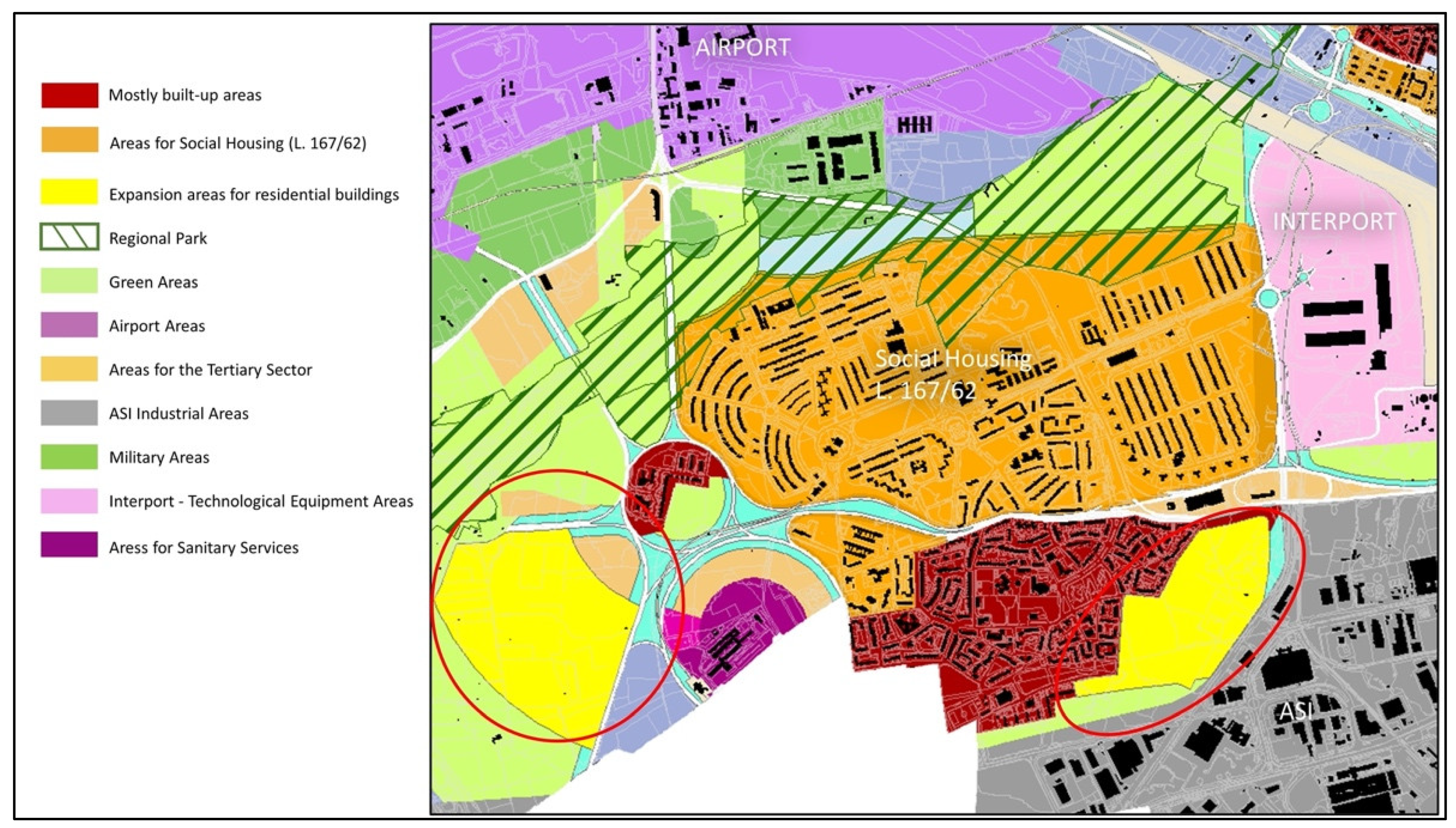
2.1. Study Area
2.2. Materials and Methods for the Analysis of Alternative Development Scenarios
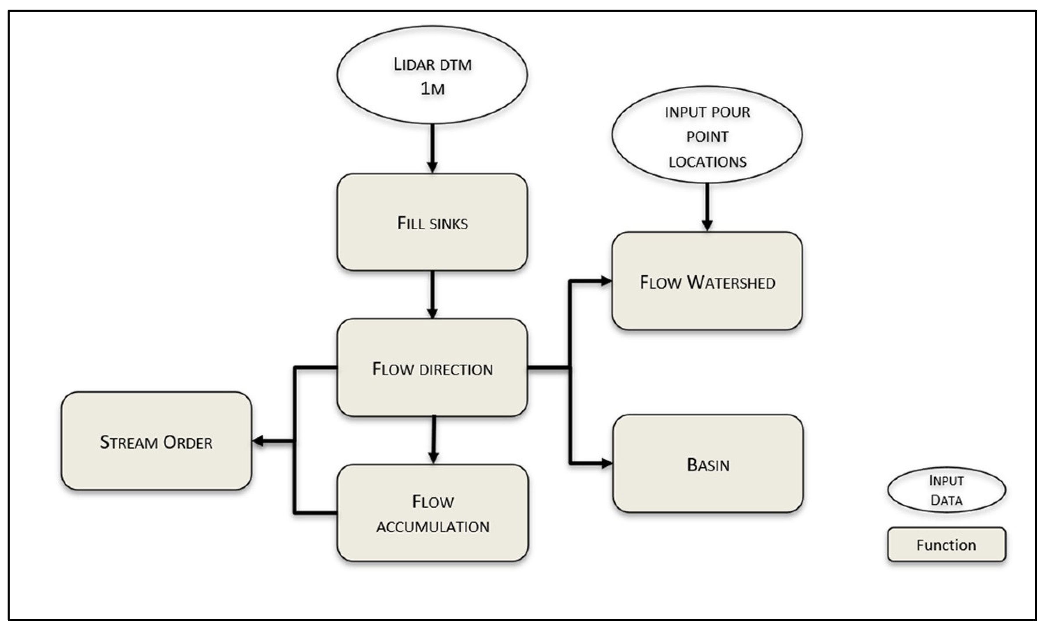
2.3. Urban Water Flow Model
2.3.1. Fill Sinks
2.3.2. Flow Direction
2.3.3. Flow Accumulation
2.3.4. Basin and Watershed
2.3.5. Stream Order
3. Results
3.1. Alternative Land use Scenarios for the San Paolo Neighborhood
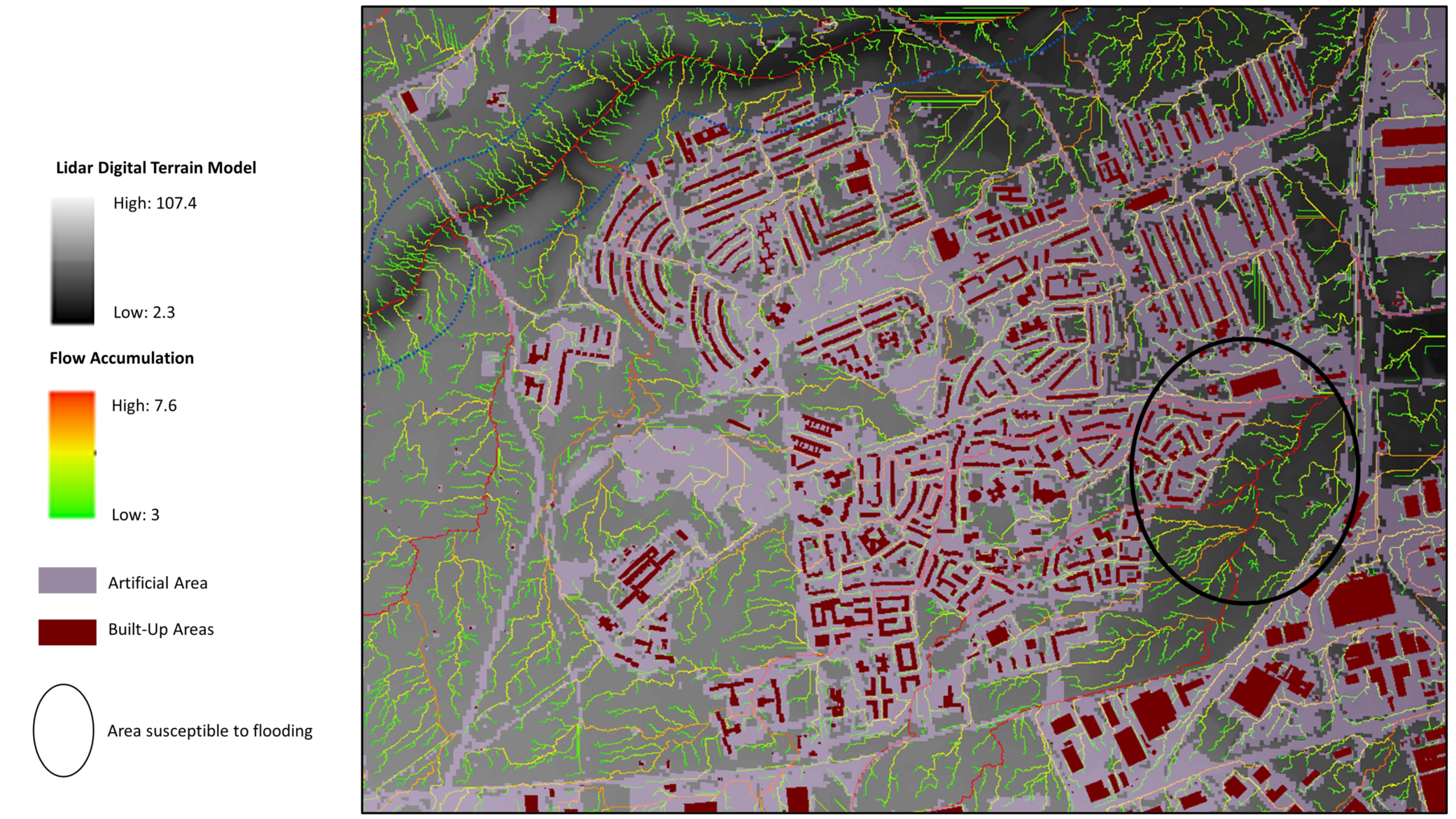
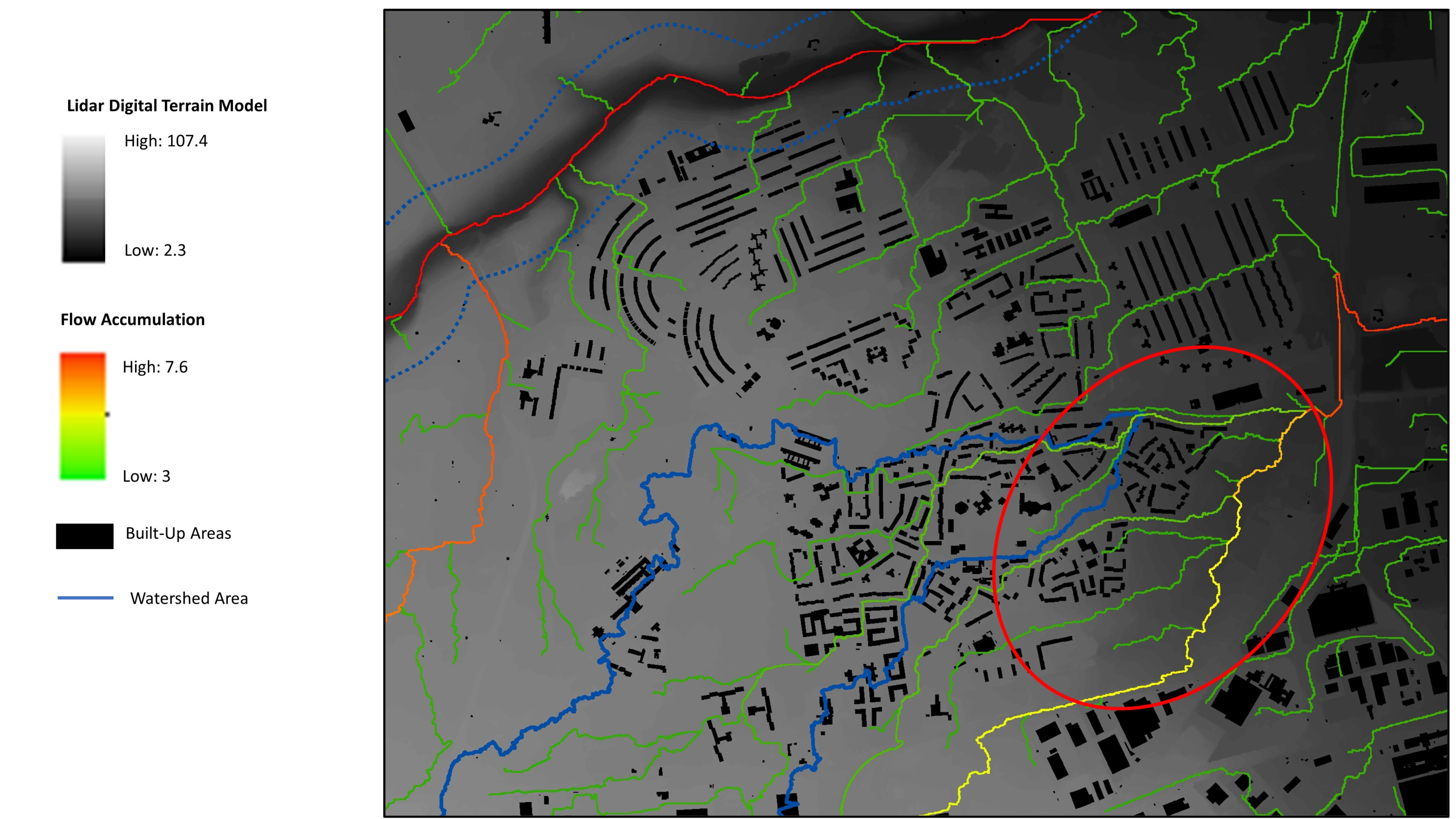
3.2. Water Flow Scenarios
4. Discussion
5. Conclusions
- (1)
- In the strategic environmental assessment phase, it guides the plan and, indeed, becomes a perfect integral part of it;
- (2)
- In the phase of urban landscape management and planning of the adaptation of the city to climate change.
Author Contributions
Funding
Institutional Review Board Statement
Informed Consent Statement
Data Availability Statement
Conflicts of Interest
References
- ESPON. ESPON Climate—Climate Change and Territorial Effects on Regions and Local Economies in Europe. 2021. Available online: www.espon.eu/climate (accessed on 7 December 2021).
- EEA. Urban Adaptation in Europe: How Cities and Towns Respond to Climate Change. EEA Report No. 12/2020; Publications Office of the EU: Luxembourg, 2020. [Google Scholar]
- Pelorosso, R.; Leone, A.; Boccia, L. Land Cover and Land Use Change in the Italian Central Apennines: Comparison among Assessment Methods. Appl Geogr. 2009, 29, 35–48. [Google Scholar] [CrossRef]
- Pelorosso, R.; Gobattoni, F.; Leone, A. Increasing Hydrological Resilience Employing Nature-Based Solutions: A Modelling Approach to Support Spatial Planning. In Smart Planning: Sustainability and Mobility in the Age of Change; Papa, R., Fistola, R., Eds.; Springer: Cham, Switzerland, 2018; pp. 71–82. [Google Scholar]
- Gobattoni, F.; Pelorosso, R.; Piccinni, A.F.; Leone, A. The Sustainability of the Urban System From a Hydrological Point of View: A Planning Practice Proposal. UPLanD 2017, 2, 101–122. [Google Scholar]
- Chow, W.T. Handbook of Applied Hydrology; Mc Graw-Hill: New York, NY, USA, 2010. [Google Scholar]
- Leone, A.; Gobattoni, F.; Pelorosso, R.; Balena, P. L’uso del suolo agricolo è il fattore chiave per la sicurezza dei territori fragili. In Proceedings of the XXII Conference SIU: L’urbanistica Italiana di Fronte all’Agenda 2030, Bari, Italy, 5–7 June 2019; pp. 857–862. [Google Scholar]
- Ericksen, N.J. Creating Flood Disasters? New Zealand’s Need for a New Approach to Urban Flood Hazard; Water and Soil Directorate, Ministry of Works and Development: Wellington, New Zealand, 1986.
- EU. Towards an EU Research and Innovation Policy Agenda for Nature-Based Solutions & Renaturing Cities; CEC: Brussels, Belgium, 2015. [Google Scholar]
- Senes, G.; Ferrario, P.S.; Cirone, G.; Fumagalli, N.; Frattini, P.; Sacchi, G.; Valè, G. Nature-Based Solutions for Storm Water Management—Creation of a Green Infrastructure Suitability Map as a Tool for Land-Use Planning at the Municipal Level in the Province of Monza-Brianza (Italy). Sustainability 2021, 13, 6124. [Google Scholar] [CrossRef]
- Haase, D.; Larondelle, N.; Andersson, E.; Artmann, M.; Borgström, S.; Breuste, J.; Gomez-Baggethun, E.; Gren, Å.; Hamstead, Z.; Hansen, R.; et al. A quantitative review of urban ecosystem service assessments: Concepts, models, and implementation. Ambio 2014, 43, 413–433. [Google Scholar] [CrossRef] [PubMed]
- Gómez-Baggethun, E.; Barton, D.N. Classifying and valuing ecosystem services for urban planning. Ecol. Econ. 2013, 86, 235–245. [Google Scholar] [CrossRef]
- Green, O.O.; Garmestani, A.S.; Albro, S.; Ban, N.C.; Berland, A.; Burkman, C.E.; Gardiner, M.M.; Gunderson, L.; Hopton, M.E.; Schoon, M.L.; et al. Adaptive governance to promote ecosystem services in urban green spaces. Urban Ecosyst. 2016, 19, 77–93. [Google Scholar] [CrossRef]
- Council of Europe. European Landscape Convention. ETS No. 176; Council of Europe: Strasbourg, France, 2022; Available online: https://rm.coe.int/1680080621https://rm.coe.int/1680080621 (accessed on 16 September 2022).
- Laera, R.; Riccardi, C. Ludovico Quaroni, il piano di Bari e l’idea di “città regione”. Piano Progett. Città 1990, 09/10, 38–44. [Google Scholar]
- Calace, F. La legge dei grandi numeri del Piano di Bari. In Una Geografia delle Politiche Urbane tra Possesso e Governo. Sfide e Opportunità nella Transizione, Working Papers—Urban@it, 12; Perrone, C., Masiani, B., Tosi, F., Eds.; Dipartimento di Architettura dell’Università di Bologna: Bologna, Italia, 2021; pp. 230–239. [Google Scholar]
- Cucciolla, A.; di Bari, P., II. Note per una lettura sistematica. Piano Progett. Città 1990, 09/10, 45–72. [Google Scholar]
- Calace, F.; Paparusso, O.G. Regional landscape planning for the innovation of urban planning. Municipal implementation of the city-country pact in Apulia. City Territ. Archit. 2022, 9, 25. [Google Scholar] [CrossRef]
- Barbanente, A.; Grassini, L. Fostering innovation in area-based initiatives for deprived neighbourhoods: A multi-level approach. Int. Plan. Stud. 2019, 25, 206–221. [Google Scholar] [CrossRef]
- Barbanente, A.; Grassini, L. Fostering transitions in landscape policies: A multi-level perspective. Land Use Policy 2022, 112, 105869. [Google Scholar] [CrossRef]
- Cialdea, D.; Leone, A.; Muscio, V. Landscape and the city. A new vision for enhancing sustainability issues. TeMA—J. Land Use Mobil. Environ. 2022, in press. [Google Scholar]
- Marks, D.; Dozier, J.; Frew, J. Automated basin delineation from digital elevation data. Geo-Processing 1984, 2, 299–311. [Google Scholar]
- O′Callaghan, J.F.; Mark, D.M. The extraction of drainage networks from digital elevation data. Comput. Gr. Image Process 1984, 28, 323–344. [Google Scholar] [CrossRef]
- Shreve, R.L. Statistical law of stream numbers. J. Geol. 1966, 74, 17–37. [Google Scholar] [CrossRef]
- Albrechts, L.; Barbanente, A.; Monno, V. Practicing Transformative Planning: The Territory-Landscape Plan as a Catalyst for Change. City Territ. Archit. 2020, 7, 1–13. [Google Scholar] [CrossRef]
- Comune di Bari, Documento Programmatico Preliminare per il Piano Urbanistico Generale—Elaborati Grafici, 2010 (Preliminary Programmatic Document (DPP) for the PUG—Maps). Available online: https://www.comune.bari.it/web/edilizia-e-territorio/elaborati-grafici (accessed on 15 July 2022).
- Comune di Bari, Documento Programmatico Preliminare per il Piano Urbanistico Generale—Relazione Generale, 2010 (Preliminary Programmatic Document (DPP) for the PUG—General Report). Available online: https://www.comune.bari.it/web/edilizia-e-territorio/relazione-generale (accessed on 15 July 2022).
- Barbanente, A.; Grassini, L. Integrating nature-based solutions into urban planning and policies: Learning from the Apulia case study. In Innovation in Urban and Regional Planning, Lecture Notes in Civil Engineering Series, 242; La Rosa, D., Privitera, R., Eds.; Springer: Cham, Switzerland, 2022; Volume 2, pp. 12–21. [Google Scholar]
- Comune di Bari, Documento Programmatico per la Rigenerazione Urbana, 2011 (Programmatic Document for the Urban Regeneration). Available online: https://www.comune.bari.it/documents/114869/651878/01.+Copertina+e+indice+%28agg.+dicembre+2010%29.pdf/6eec860c-5d67-45a8-8027-dfdde6d726c9 (accessed on 15 July 2022).
- Recanatesi, F.; Petroselli, A.; Ripa, M.N.; Leone, A. Assessment of Stormwater Runoff Management Practices and BMPs Under Soil Sealing: A Study Case in a Peri-Urban Watershed of The Metropolitan Area Of Rome (Italy). J. Environ. Manag. 2017, 201, 6–18. [Google Scholar] [CrossRef] [PubMed]
- CEC-European Commission. The EU Compendium of Spatial Planning Systems and Policies, Regional Development Studies 28; Office for Official Publications of the European Communities: Luxembourg, 1997. [Google Scholar]
- Palme, U. Multiple conceptions of sustainable urban water systems: A problem or asset? Water Policy 2010, 12, 425–443. [Google Scholar] [CrossRef]
- Cettner, A.; Ashley, R.; Viklander, M.; Nilsson, K. Stormwater management and urban planning: Lessons from 40 years of innovation. J. Environ. Plan. Manag. 2013, 56, 786–801. [Google Scholar] [CrossRef]
- Reckien, D.; Flacke, J.; Dawson, R.J.; Heidrich, O.; Olazabal, M.; Foley, A.; Hamann, J.J.-P.; Orru, H.; Salvia, M.; De Gregorio Hurtado, S.; et al. Climate change response in Europe: What’s the reality? Analysis of adaptation and mitigation plans from 200 urban areas in 11 countries. Clim. Change 2014, 122, 331–340. [Google Scholar] [CrossRef]
- Reckien, D.; Flacke, J.; Olazabal, M.; Heidrich, O. The influence of drivers and barriers on urban adaptation and mitigation plans: An empirical analysis of European cities. PLoS ONE 2015, 10, e0135597. [Google Scholar] [CrossRef] [PubMed]
- Pietrapertosa, F.; Salvia, M.; de Gregorio Hurtado, S.; d’Alonzo, V.; Church, J.M.; Geneletti, D.; Musco, F.; Reckien, D. Urban climate change mitigation and adaptation planning: Are Italian cities ready? Cities 2019, 91, 93–105. [Google Scholar] [CrossRef]
- Qiao, X.J.; Kristoffersson, A.; Randrup, T.B. Challenges to implementing urban sustainable stormwater management from a governance perspective: A literature review. J. Clean. Prod. 2018, 196, 943–952. [Google Scholar] [CrossRef]
- Bohman, A.; Glaas, E.; Karlson, M. Integrating sustainable stormwater management in urban planning: Ways forward towards institutional change and collaborative action. Water 2020, 12, 203. [Google Scholar] [CrossRef]
- Brown, R.R.; Farrelly, M.A. Challenges ahead: Social and institutional factors influencing sustainable urban stormwater management in Australia. Water Sci. Technol. 2009, 59, 653–660. [Google Scholar] [CrossRef] [PubMed]


Publisher’s Note: MDPI stays neutral with regard to jurisdictional claims in published maps and institutional affiliations. |
© 2022 by the authors. Licensee MDPI, Basel, Switzerland. This article is an open access article distributed under the terms and conditions of the Creative Commons Attribution (CC BY) license (https://creativecommons.org/licenses/by/4.0/).
Share and Cite
Leone, A.; Grassini, L.; Balena, P. Urban Planning and Sustainable Storm Water Management: Gaps and Potential for Integration for Climate Adaptation Strategies. Sustainability 2022, 14, 16870. https://doi.org/10.3390/su142416870
Leone A, Grassini L, Balena P. Urban Planning and Sustainable Storm Water Management: Gaps and Potential for Integration for Climate Adaptation Strategies. Sustainability. 2022; 14(24):16870. https://doi.org/10.3390/su142416870
Chicago/Turabian StyleLeone, Antonio, Laura Grassini, and Pasquale Balena. 2022. "Urban Planning and Sustainable Storm Water Management: Gaps and Potential for Integration for Climate Adaptation Strategies" Sustainability 14, no. 24: 16870. https://doi.org/10.3390/su142416870
APA StyleLeone, A., Grassini, L., & Balena, P. (2022). Urban Planning and Sustainable Storm Water Management: Gaps and Potential for Integration for Climate Adaptation Strategies. Sustainability, 14(24), 16870. https://doi.org/10.3390/su142416870