Article

Climate Change during the Third Millennium—The Gulf Cooperation Council Countries

by
Mohamed E. Hereher
1,2
1
Department of Environmental Sciences, Faculty of Science, Damietta University, New Damietta 34517, Egypt
2
Geography Department, College of Arts and Social Sciences, Sultan Qaboos University, Muscat 123, Oman
Sustainability 2022, 14(21), 14181; https://doi.org/10.3390/su142114181
Submission received: 21 April 2022 / Revised: 24 May 2022 / Accepted: 27 May 2022 / Published: 31 October 2022

Abstract

:
The Gulf Cooperation Council (GCC) is a union occurring in the arid subtropical belt of the world. Contemporary climate change is a serious environmental issue at the regional and global levels. The main purpose of this study was to investigate the changes and trends in the regional climate in the GCC countries in terms of the land surface temperatures and surface anomalies, precipitation, and sea surface temperatures over the first two decades of this millennium. Research data exclusively relied on satellite remote sensing. Spatial, statistical, and cartographic analyses were performed to extract, manipulate, and display thematic maps reflecting the changes and trends of the regional climate. The results showed that notable climate changes were obvious and frequent throughout the GCC countries, with symptoms influencing the atmosphere, lithosphere, and the hydrosphere of the region. However, a prominent gradient in the severity of climate change occurred from north to south. Remarkably, serious impacts were observed in Kuwait and eastern Saudi Arabia, while the least effects were recorded in Oman. The study denotes the competence of remote sensing for monitoring regional climate change.

1. Introduction

The global CO2 emissions increased from 6 billion tons in 1950 to 22 billion tons in 1990 and eventually approached 34 billion tons in 2020 [1]. As it contains more than 60% of the world’s population, Asia is the largest contributor of CO2 in the world, with about 53% of global emissions. There is a direct correlation between the high rates of greenhouse gas (GHG) emissions (mostly CO2 and methane) from burning fossil fuels (oil, gas, and coal) and global warming [2]. This issue of climate change has received universal interest in the last decades. International endeavors pursue the goal of keeping global warming from approaching 2 °C by encouraging the countries that emit the most GHGs to restrict the increase in global temperatures below 1.5 °C [3]. However, the rates of GHG emission could increase the global temperatures by 6 °C by the end of this century [4]. Recently, the United Nations Climate Change Conference (COP26), which was held in November 2021 in Glasgow, Scotland, emphasized again the responsibility of all countries to limit the world temperature increase by 1.5 °C above the pre-industrial revolution levels. The world witnesses not only enormous emissions of GHGs but many other air pollutants as well. Hence, global warming is just one facet of the problem. Air pollution is considered the most significant environmental health issue in the world. It ranks among the top five risks for attributable deaths globally [5] and causes about 4.2 million premature deaths every year [6]. Air pollution consists of particulate matter and gaseous constituents, e.g., sulfur dioxide (SO2), nitrogen dioxide (NO2), ozone, particulates, and carbon monoxide (CO).
The Gulf Cooperation Council (GCC) is a regional geographical union established in 1981 between six Arab countries (Kuwait, Saudi Arabia, Bahrain, Qatar, United Arab Emirates, and Oman) (Figure 1). These oil-producing countries are all experiencing remarkable socio-economic developments depending on their tremendous fossil fuel production (Table 1). They hold approximately 40% of the world’s known oil and about 24% of the world’s known gas reserves [7]. These states have also experienced accelerated population growth accompanied by extensive energy utilization. Energy consumption in the GCC countries is the highest in the world and is as much as 2.5 times the consumption of the European Union [8]. There is a direct relationship between energy consumption and CO2 emissions as well as between economic growth and energy consumption in the GCC countries [9]. All the GCC countries are listed as being among the largest per capita CO2 emitters in the world, as they emit 3.08% of global CO2, with the maximum being from Saudi Arabia (1.8%) in 2020. Major sources of GHGs and air pollutants in the GCC countries are numerous. However, the burning of fossil fuels for energy, transportation, petrochemical industries, and oil refineries are at the top. Unfortunately, regional studies on GHGs and air pollution studies are generally few. However, there are some local investigations that demonstrate the rates of GHG emissions and their projections for the near future. For example, CO2 emissions have tripled in Oman between 2000 and 2014 due to the expansion of the industrial sector [10]. Ref. [11] showed that the CO2 emissions from the transportation sector of Saudi Arabia increased from 2000 through 2010 to 2020 to a total of 56 million tons, 98 million tons, and 163 million tons, respectively. In the United Arab Emirates (UAE), the major emissions (90%) of GHGs are produced from the energy sector [12].
The GCC region is under a hot desert climate (BWh), according to the Koppen climate classification. Summers are generally hot to extremely hot, and air temperatures usually approach 40 °C during the summer months. However, winters are generally mild with temperatures seldom falling below 10 °C, particularly in coastal regions. Rainfall in the area is generally scant, except for in Oman, where Al-Hajar Mountain receives up to 300 mm/year. The relative humidity is high (up to 85%) along the coastal zones. The GCC countries are usually exposed to frequent dust storms accompanying the Al-Shamal (northern in Arabic) winds, and these storms can significantly reduce visibility and cause problems regarding the air and traffic [13]. The region is experiencing fast population growth. The majority of the region’s population resides in Saudi Arabia, UAE, Kuwait, and Oman. The total population of the GCC countries exceeds 50 million [14].
The impacts of climate change on the GCC region were also addressed in some previous studies, with a particular focus on air temperatures, precipitation, and the Arabian Gulf environment. For example, Ref. [15] observed a tendency toward increasing drought intensity and frequency between 1981 and 2000 over the Arabian Peninsula due to climate change. Ref. [13] reported a significant increase in air temperatures between 1996 and 2010. Ref. [16] observed that between 2003 and 2018, the annual increase in the gulf water surface temperatures exceeded the global ocean warming that occurred since 1900. In addition, Ref. [17] reported a correlation between the warming of seawater and the locations of bleached coral reefs in the Arabian Gulf. Moreover, Ref. [18] observed significant nighttime warming caused by the urban heat islands of the major cities in the region, particularly in Dubai (1.9 °C/decade). The warming of the climate is generally associated with drought, an increase in the frequency of heatwaves, the deterioration of terrestrial biodiversity and marine ecosystems, and sea-level rise [19,20,21]. To the best of the author’s knowledge, there has been little major research on regional climate change, and most of the published work was at the country level. In addition, the majority of the previous studies relied on data from existing ground meteorological stations, which are relatively little in space compared to the huge area of the region. The present study entirely depends on remotely sensed data, which covers all the spatial gaps and boundaries of the region. In addition, there is a necessity for regional climate change studies in order to determine appropriate management procedures and to prioritize the available natural resources in the region with particular focus upon the renewable resources [22,23,24,25,26]. Therefore, the present study attempts to fill the gap in the literature and provides a comprehensive regional and synoptic overview on the status of climate change over the past two decades using remotely sensed data. The goal is to focus on the decadal changes in the land surface temperatures, precipitation, and sea surface temperatures, as revealed by satellite images. Therefore, the current research aims to answer the following questions: 1—what are the temporal regional changes in the emission of GHGs and air pollution? 2—are there any changes in land surface temperatures, precipitation, and sea surface temperatures? And 3—what are the decadal rates of these changes? The time frame of most studied parameters extends to two decades, while some others extend to 40 years.

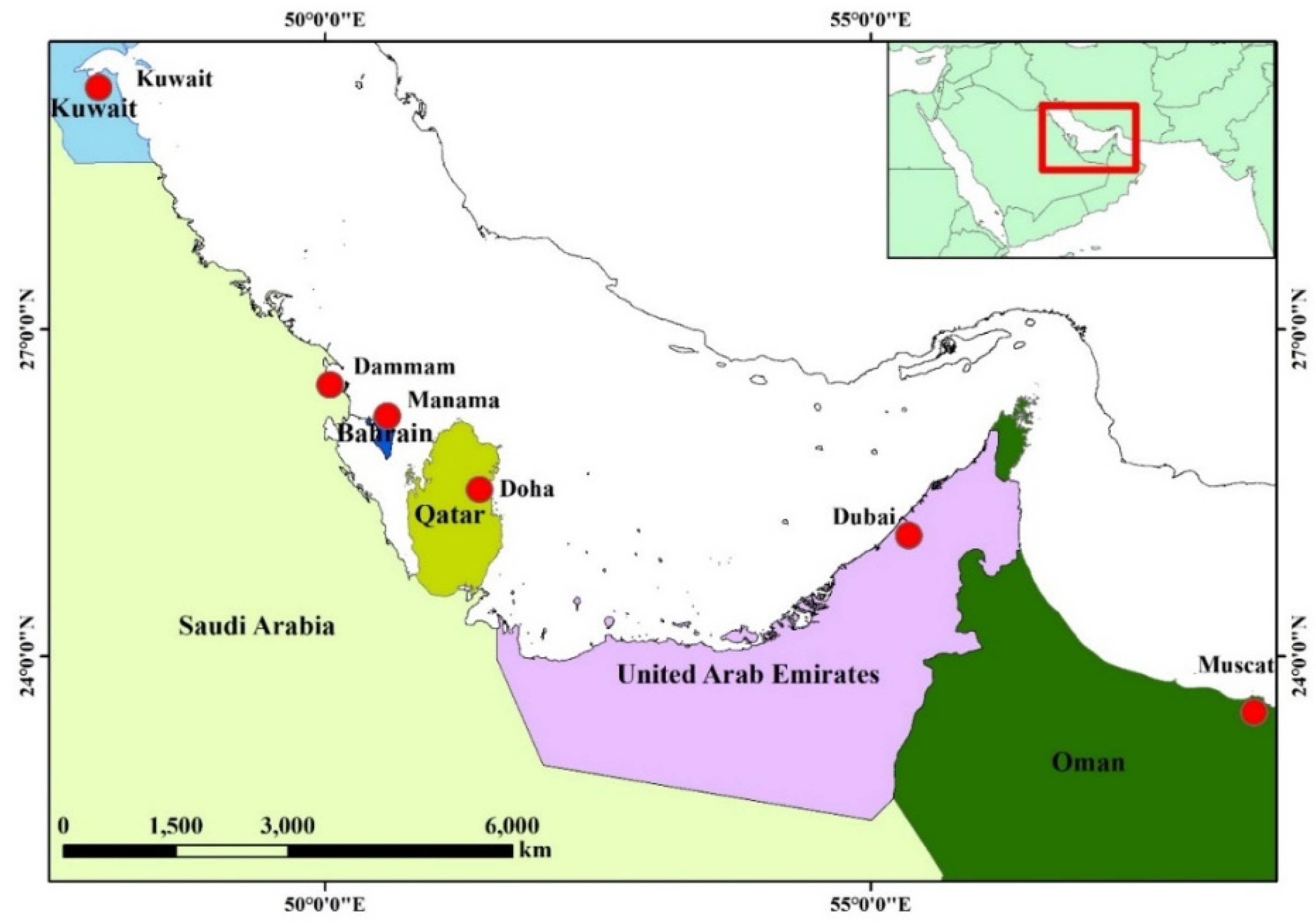
2. Materials and Methods

2.1. Atmospheric Data

In this investigation, the goal was to probe into the geographical changes of atmospheric constituents, considering those that are the most related to global warming and climate change in this important fossil fuel stock region. The atmospheric data include two GHGs: carbon dioxide (CO2) and methane (CH4), as well as three air pollutants: sulfur dioxide (SO2), nitrogen dioxide (NO2), and black carbon (BC). The data utilized are gridded (monthly/daily records) time series raster images covering the entirety of the GCC countries along the Arabian Gulf (Table 2). All these data were acquired by means of remote sensing. The CO2 and CH4 datasets cover the periods 2003–2016 and 2003–2020, respectively. On the other hand, the dataset of BC and SO2 extends to 40 years (1980–2020), while NO2 data cover the period 2005–2020. The data were acquired for a window covering the entirety of the GCC countries overlooking the Arabian Gulf. All the data were downloaded from the Geospatial Interactive Online Visualization and Analysis Infrastructure (Giovanni) (https://giovanni.gsfc.nasa.gov/giovanni/, (accessed on 11 November 2021)) portal; Version (V.4.36). Giovanni is a web-based platform developed by the Goddard Earth Sciences Data and Information Services Center (GES DISC) that provides a simple and instinctive way to visualize, analyze, and access the earth science remotely sensed data acquired from many sources and satellites, such as TRMM, TOMS, OMI, AIRS, MERRA, MLS, MODIS, etc. [27]. These data were provided as daily or monthly records shown as timely averaged maps in different spatial resolutions ranging from 0.25 × 0.25 to 2 × 2.5 degrees in GeoTiff format and at the Geographical Coordinate System (GCS).

2.2. Land Surface Temperatures and Precipitation Data

The Land Surface Temperature (LST) data were acquired from the Moderate Resolution Imaging Spectroradiometer (MODIS) instrument onboard the Aqua satellite. In this study, LST data were selected from the MYD11B3.V6 product, which provides average monthly land surface temperature in a pixel size of 0.05° × 0.05° (5600 m × 5600 m) within a 1200 by 1200 km (km) tile. This product provides both daytime (at 13:30) and nighttime (01:30) land surface temperatures. MODIS data were found to well agree with ground LSTs, as they were validated in different environments, including lakes, vegetation, and soil sites in clear sky conditions by the radiance-based approach to have a mean bias within 1 K [28]. The LST data were obtained from the NASA’s Land Processes Distributed Active Archive Center (LP DAAC) (https://lpdaac.usgs.gov, (accessed on 1 December 2021)) from the tiles H22V06 and H23V06 for the period from January 2003–December 2020. In this investigation, the daytime LST images were extracted from the MYD11B3 product on a monthly basis, and the digital numbers were converted to degrees Celsius at the pixel level. The two tiles were mosaicked together in order to compile one continuous image, and a subset covering the study area was then produced. In addition, the nighttime anomalies of surface air temperatures were also investigated. Surface nighttime temperature anomalies data were also acquired from the Giovanni web portal for the period from 2003–2016. The data were acquired from the Atmospheric Infrared Sounder (AIRS) satellite for the main cities along the Arabian Gulf. Regarding precipitation, gridded data were acquired from the World Climate (https://www.worldclim.org, (accessed on 19 February 2022)) web portal. This platform provides a monthly raster database of the global monthly precipitation obtained via the reanalysis of 9000 to 60,000 ground weather stations worldwide for the period from 1960–2018 via interpolation techniques. The global cross-validation correlations were 0.86 for precipitation, revealing high confidence estimations. Details on acquiring, processing, and validating these climate data are shown in Ref. [29]. In the present study, the monthly precipitation dataset acquired between 2000 and 2018 was downloaded at 2.5° × 2.5° (~20 km2) for the GCC region in GeoTiff format. The precipitation profile for the study area was generated, from which the mean annual precipitation and the decadal trend were statistically determined.

2.3. Sea Surface Temperatures Data

The GCC countries overlook the western side of the Arabian Gulf. The oceanographic characteristics of this semi-enclosed inland sea are affected by the regional climate. Therefore, climate change should influence not only the lithosphere but the hydrosphere as well. The sea surface temperatures (SST) of the gulf water were extracted by thermal remote sensing satellites. In this context, MODIS data are highly beneficial for mapping SST gradients and have high confidence results, as they significantly correlate to the in situ SST measurements [30]. They have been processed and calibrated by the NASA technical laboratories using the most recent updates and algorithms. In this study, level-3 (9 km) global monthly SST data for the period of 2003–2018 were downloaded from the NASA Ocean Color web portal (http://oceancolor.gsfc.nasa.gov, (accessed on 19 May 2019)). The monthly images were stacked together, the entire time series profile was produced, and the geographical subset of the gulf was extracted.

2.4. Data Analysis and Visualization

In the beginning, all the acquired data were re-projected to the Geographical Coordinate System. However, the pixel size of all images in each parameter was kept without resampling, as each element was independently treated. For each parameter, images of the individual monthly records were stacked together, forming one file of multi-date profiles (from the first to the last date) for this parameter. This raster dataset was then converted to vector data in a tabular format (the American Standard Code for Information Interchange, ASCII) for consequent analysis. For each parameter, the converted ASCII table shows the coordinates and the record of each point for every date in the time series. This table was eventually used for statistical analysis. The monthly and annual average values for each point for each parameter were computed from the monthly records to yield a mean layer for that parameter. In addition, the rate of change at every point of that parameter was obtained from the slope of the linear regression relationship of the time series records. For example, the LST for a given pixel at a given date is calculated as follows:
Y = α X + β
where X, Y, α, and β are the time, LST, slope, and intercept, respectively. The modeled slope of the regression (α) was defined as the temperature rate of change (°C/decade). In the same manner, the decadal trend for every studied parameter was determined at the pixel level. The tables of the mean and trend for each parameter were displayed in ArcMap for interpolation analysis. The Inverse Distance Weighted (IDW) algorithm is the interpolator used to produce the surface of distribution maps of the mean and rate of change throughout the study region. This technique, which considers the spatial density of data points when producing the continuous surface, is widely used in environmental and climatic studies [31,32]. Thematic maps for the mean and decadal trends of each parameter, including the atmospheric, terrestrial, and sea surface temperature changes, were prepared and visualized. In addition to the regional mean and trend maps, all the GHGs and air pollutants were investigated to reveal the monthly profile during the study period of each parameter. Then the monthly distribution pattern was analyzed for the main cities overlooking the Arabian Gulf (Kuwait City, Dammam, Manama, Doha, Dubai, and Muscat), and a window of 50 × 50 km was selected for each city. The monthly profiles for GHG/air pollutant parameters for these cities were displayed in order to visualize the temporal variations of these inputs to the atmosphere.

3. Results

3.1. Greenhouse Gases and Air Pollution

All the GCC countries are experiencing notable high emissions of greenhouse gases [33]. There has been a significant increase in the CO2 gas concentration throughout the entire region, which increased from 375 ppm in 2003 to 402 ppm in 2016. Figure 2a shows that the mean CO2 emissions were remarkably high in Kuwait, KSA, Bahrain, Qatar, and UAE. This high concentration reflects the dependence of these countries upon crude oil for their energy, industry, and transport sectors. Globally, two-thirds of carbon dioxide (CO2) originated from the energy sector [26]. The decadal trend of CO2 gas emissions (Figure 2b) revealed maxim emission rates in Kuwait, KSA, and UAE (up to 21.6 ppm/decade). Saudi Arabia alone contributed 1.8% of the global CO2 emissions in 2020 [26]. The lower rates of emissions were clearly observed in areas that were farther away from the gulf in the Arabian desert. At the monthly level, it was observed that the concentrations of CO2 are higher during spring and summer, with the maximum values occurring during May and June. The lowest concentrations were recorded in January and October (Figure 2c). The highest monthly CO2 record ever was observed in Dubai in June.
Methane (CH4) is considered a major greenhouse gas that is responsible for global warming. In contrast to CO2 gas, methane has a short lifetime (~12 years); however, it absorbs much energy in the troposphere compared to CO2 [34]. The energy sector, which depends on oil and gas reserves, is the primary source of atmospheric methane. The distribution of the mean monthly concentration of CH4 emissions between 2003 and 2020 (Figure 3a) revealed that many emissions were clear in UAE (1862 ppbv), Kuwait (1860 ppbv), and Saudi Arabia (1854 ppbv). In addition, there has been a notable increase in the decadal rate of emissions in the GCC countries, with maximal rates in Oman (456 ppbv/decade) and UAE (437 ppbv/decade). This is evident in the increase in CH4 emissions in Oman (mainly from the energy sector), which increased from 288 Gg in 2000 to 825 Gg in 2015 [35]. The peak emission was observed during August, whereas the lowest record was observed during February (Figure 3c).
The three air pollutants analyzed in this study are SO2, NO2, and black carbon. SO2 concentrations and trends are shown in Figure 4. The primary sources of SO2 are oil refineries, desalination, and power plants using diesel [14,36]. The mean monthly concentrations of SO2 for the period from 1980–2020 revealed maximum values in both the Dammam region of Saudi Arabia (15 µg/m3) and Kuwait (13 µg/m3). The decadal trends concurred with the monthly averages, where maximal trends occurred in these two locations. Specifically, KSA and Kuwait are among the top 25 countries producing SO2 in the world in 2018 [37]. In addition, Ref. [38] reported that SO2 emissions from power plants in Kuwait are greatly exceeding the annual national standards (80 µg/m3). At the monthly level (Figure 4c) and in contrast to the CO2 emissions, winter and fall witnessed maximum SO2 emissions, while the minimum was recorded during June and July.
The distribution of NO2 is correlated mainly to the road traffic and to the indoor use of stoves, heaters, and fossil-fuel-burning appliances [39]. Therefore, it is obvious that the high mean concentrations of this pollutant are apparent in all the metropolitan agglomerations of the GCC countries, such as Kuwait City, Dammam, Manama, Doha, and Dubai (Figure 5a) during the period from 2005–2020. The maximum monthly concentrations were observed in Abu Dhabi (9.2 Molecules/cm2) and Kuwait cities (8.9 Molecules/cm2). Interestingly, Ref. [40] reported that the GCC countries with high NO2 emissions are UAE, KSA, and Kuwait. In addition, higher NO2 from traffic was also reported in Kuwait City [41] and Abu Dhabi, UAE [40]. However, the decadal rate of NO2 revealed recent inputs from other regions, such as Sohar in northern Oman (Figure 5b). This is confirmed by Ref. [42], who reported that the traffic near Sohar City in Oman yields double the average concentration of NO2. In contrast, some cities, such as Dammam, experienced a decrease in the decadal trend. It is also clear that all the GCC cities have comparable monthly emissions, with relatively high emissions during the winter months (Figure 5c).
Black carbon (BC) is considered to be a fine carbonaceous particulate matter (PM2.5) and occurs in the exhaust of the diesel-engine vehicles due to the incomplete combustion of fossil fuel. It is also produced from non-fossil fuels, such as biomass combustion [43]. It is a significant source of climate change. Specifically, BC is the second largest anthropogenic contributor to global warming after CO2 [44]. This pollutant was clearly observed in the GCC countries between 1980 and 2020, particularly in UAE and Kuwait. The maximum monthly averages were observed in Dubai (0.73 µg/m3) and Kuwait (0.57 µg/m3). The decadal trends were also remarkably the highest in both Kuwait and UAE (Figure 6a,b). The monthly distribution pattern was shown to be high during the late spring and early summer months, while the minimum values were recorded in January (Figure 6c). The peak occurrence of BC was encountered in Dubai, either at the monthly level, the annual mean, or the decadal trend.

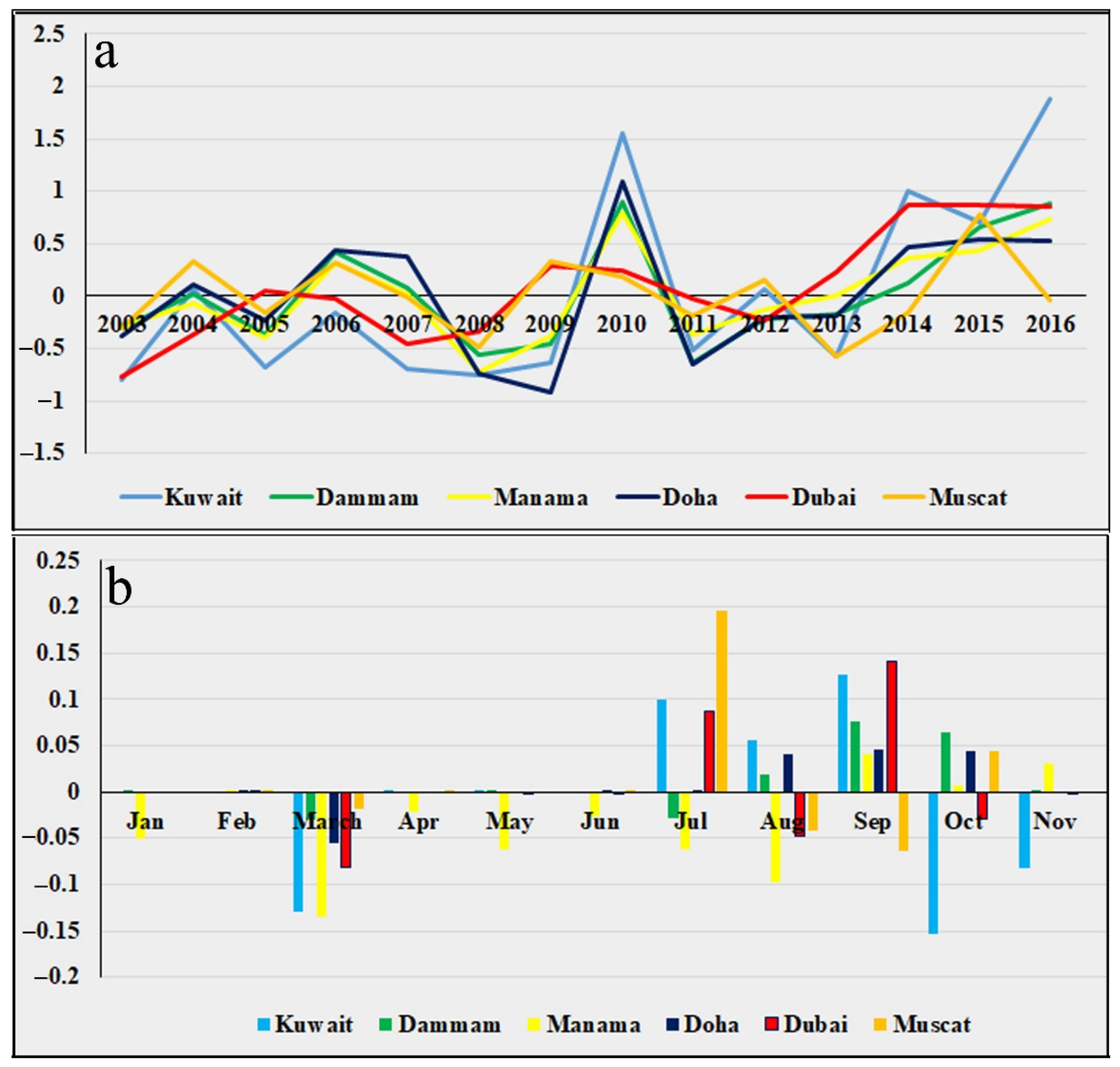
3.2. Precipitation, Land Surface Temperatures and Anomalies of Surface Temperatures

The annual rainfall along the GCC countries for the period 2000–2018 significantly varies from one country to another. It is discernable that the mountainous ranges in Oman and UAE receive the maximum rainfall (>300 mm/year) by the orographic and monsoonal rains from the Indian Ocean [13]. The remaining parts receive less precipitation (~50 mm/year), except for northeastern Saudi Arabia, which receives relatively higher annual rainfall (up to 150 mm) (Figure 7a). The majority of rainfall occurs during winter; however, heavy torrential rainstorms may hit the region during fall and spring. The statistical analysis of the precipitation trends for this period (2000–2018) indicated a clear decrease (9.7 mm/decade) in precipitation, mostly over Kuwait and some parts of the KSA. On the other hand, Al-Hajar Mountain in northern Oman and the northern part of UAE are witnessing a rise in precipitation rates (up to 12.6 mm/decade). This is obvious due to the recent increase in the frequency of torrential rainstorms over Al-Hajar Mountain in Oman.
The mean values of the land surface temperatures (LST) for the period from 2003–2020 showed higher records for the southern GCC countries, e.g., UAU and Oman, where the mean LSTs approached 50 °C for the plains and sandy terrains of these countries. The highlands in Oman and UAE have conspicuously lower LST than surrounding plateaus (Figure 8a). The northern section of the GCC courtiers, including Kuwait, KSA, Bahrain, and Qatar, exhibited relatively lower mean LST, with a difference approaching 10–15 °C, as this region experiences colder winters than UAE and Oman due to the continental and latitudinal effects. The statistical LST trend for the study period (2003–2020) revealed a contradictory pattern to the mean values. Certainly, it is very clear that Kuwait, Bahrain, Qatar, the eastern province of KSA, and the middle part of the UAE have been exposed to a decadal LST warming (Figure 8b). Specifically, this warming has reached up to 2.0 °C/decade in Kuwait, 1.7 °C in Bahrain, and 1.5 in Dammam and Abu Dhabi (UAE). On the other hand, the inland desert of KSA and the highlands of Oman have experienced a decadal cooling in LST by about 0.1 to 0.8 °C/decade. The regional change of the LST for the entire region was toward warming by 0.62 °C/decade.
The average anomaly of nighttime surface temperature, as acquired from the AIRS satellite, showed that there has been an increase in the anomalies of extraordinary temperatures, particularly toward the warming of nights. However, it was observed that some of the GCC countries were exposed to several colder nights during the period from 2003–2016. Minimal nighttime anomalies occurred in 2005, 2008, and 2011, mostly in Kuwait and Dubai, and reached 0.6 °C below average. Nevertheless, during the years 2010, 2015, and 2016, all the GCC countries experienced extreme warmer nights that were above the annual average. This is conspicuous, with maximal anomalies approaching 0.99 °C in Kuwait, Doha, and Manama (Figure 9a). Ref. [45] attributes the anomalous increase in temperatures during 2015/2016 to the El Niño/La Niña Southern Oscillation (ENSO) event. At the monthly level, it was observed that surface temperature anomalies are frequent during summer and early fall (from July to October), and the maximal values occurred in Kuwait and Muscat. However, during March, there was a decrease in temperatures that went below the average, with a minimum value in Manama. The remaining months exhibited values close to the average records. Generally, extraordinary nighttime heatwaves were frequent in Kuwait, Manama, Doha, and Dammam between 2003 and 2016, with minimal occurrences in Muscat.

3.3. Sea Surface Temperatures

The Arabian Gulf, which is a shallow inland sea with a mean depth of about 40 m, reveals considerable variations in its sea surface temperatures. This is attributed mainly to the latitudinal location of this semi-enclosed, inland water body. In addition, the gulf environment is significantly influenced by evaporation, circulation, and lateral exchange with the Arabian Sea [46]. There is a thermal gradient in the mean LST of the gulf from south to north. The mean annual SST for the period from 2003–2018 was maximal along the coasts of UAE and Oman (~28 °C) in the south, while the coldest waters occurred near the offshores of Kuwait (~24 °C) in the north (Figure 10a). The decadal trends of SST agree with the regional LST decadal trend, where the northern section is warming up at maximal rates. This is obvious in areas where there has been a warming of 1.64 °C/decade, such as the coasts of Kuwait and KSA. The least warming was recorded near the entrance of the gulf at the Strait of Hurmuz (~0.2 °C/decade). Considerable warming (0.6–1.0 °C/decade) was also observed near the offshores of Qatar, Bahrain, and UEA (Figure 10b). The overall decadal rate of the entire gulf is 0.7 °C/decade. The low warming trend in the southern part of the gulf might be attributed to the connection with the Indian Ocean and the exchange of energy with the deep, colder water body along the Sea of Oman.

4. Discussion and Conclusions

The GCC union includes some of the countries with the most excessive energy consumption and is considered a global hub for oil and gas reserves. Lately, fossil-fuel related activities have bloomed in the region, resulting in substantial and immense emissions of greenhouse gases and air pollutants. The GCC countries have a unique socio-economic setting that relies on huge oil reserves. These countries account for about a quarter of the world’s crude oil production, mostly stemming from Saudi Arabia, the UAE, and Kuwait, and these three countries were among the ten largest producers of crude oil in the world in 2018 [47]. In addition, the majority of the GCC countries can be found in the top ten worldwide ranks of energy consumption per capita [48]. Moreover, the low energy prices have attracted foreign companies to establish investments, which has not only influenced the economy but also increased the energy demand [49]. In addition, the number of motor vehicles in GCC countries was 221% more than the average value in Asia, Oceania, and the Middle East in 2015 [50]. The excessive use of energy, specifically fossil fuels, imposes considerable pressure upon these non-renewable resources. As such, the current study proves that there are considerable emissions of GHGs and air pollution. Looking at the emissions of the two greenhouse gases (CO2 and CH4), it is clear that there has been a substantial increase in both gases during the past two decades. CO2 increased from 375 ppm to more than 400 ppm. In this context, Ref. [13] mentioned that the CO2 emissions in 2012 alone were four times the average per capita in the world. However, this increase in CO2 emission has been documented to be ubiquitous and remarkable worldwide. The present study indicates that the highest rates of emissions were encountered in KSA, UAE, and Kuwait, where energy sources rely mainly on fossil fuels [51]. In Saudi Arabia, for example, the demand for crude oil for the energy sector increased by 340% between 2006 and 2011 [52]. Simultaneously, CH4 emissions also showed increased rates in the third millennium. For a country like Oman, where the decadal rate of emission is the highest of the GCC countries, CH4 emissions from the oil and gas sectors are the primary contributor to the country’s total GHG emissions [35]. It is also remarkable that GHGs were at a maximum during the summer months and at a minimum during winter. Regionally, the GCC countries contributed 2.4% of GHG emissions during a time when only 0.6% of the world’s population was alive [53]. In addition to these GHGs, significant air pollutants also showed higher outputs into the atmosphere in GCC countries, particularly Kuwait, UAE, and KSA. In contrary to GHGs, SO2 and NO2 emissions are maximal during winter, while BC emissions are maximal during summer. The present study demonstrates that GCC countries reveal higher emissions of SO2, NO2, and BC. Many concentrations of these air pollutants are quite observable in the industrial regions of GCC countries. Consequent impacts involve the deterioration of air quality and the blooming of air-borne diseases. The health impacts of air pollution are noteworthy in GCC countries due to the higher relative humidity in the region [54]. Some studies attribute the high health risk and mortality in Kuwait to the increased levels of air pollution [55,56], while Ref. [57] claims that air pollution is responsible for 9% of mortality in Saudi Arabia. The lowest emissions of the studied air pollutants were observed in Oman.
Decadal changes in regional precipitation, land surface temperatures, and sea surface temperatures were apparent from the remotely sensed data. Statistical analysis revealed a decline in precipitation in the northern part, including the entire State of Kuwait and some parts of Saudi Arabia. This observation is confirmed by Ref. [58], who reported declining rates of rainfall in this region of the Arabian Peninsula. These results also agree with the projected climate change scenarios in terms of the aridity and drought of the Arabian Peninsula, where wetter conditions will prevail south of 25 °N and drier conditions will occur north of 25 °N [59]. Interestingly, the present study showed a relative wetting in some parts of Oman (south of 25 °N). It is worth noting that there was a substantial increase in the surface temperature anomalies during summer nights. This concept was previously established in Saudi Arabia by Ref. [60], who observed that the number of abnormal warm nights increased by 21 days during the decades between 1979 and 2019. Concurrently, remotely sensed land surface temperature analysis showed considerable warming, particularly along the northern section. The present study demonstrates that GCC countries revealed a net warming of the land by 0.6 °C/decade over the past twenty years, with maximal warming (2 °C/decade) in Kuwait. It is important to note that the rate of global temperatures increased globally by 1.1 °C in the last 150 years, with higher rates after 1970 [61]. Remarkably, Ref. [58], in their analysis regarding the changes in the regional air temperatures using data acquired from 25 meteorological stations for the period from 1980–2010, reported an increase in the air temperatures of the Arabian Peninsula by 0.63 °C/decade. In addition, Ref. [62], using data from 44 stations, reported that the Arabian Peninsula witnessed a warming trend of 0.55/decade for the period from 1980–2008. Climate change has been also observed to influence the Arabian Gulf’s surface water temperatures. Although the northern section of the gulf is the coldest, it experiences the most warming of the entire water body. The study indicates that the warming of this part of the gulf approaches 0.7 °C/decade. This was also confirmed by Ref. [63], who reported the comparable warming (0.6/decade) of the Kuwait Bay for the period from 1985–2002. The southern section of the Gulf witnessed the least warming during the study period due to the connection with the Indian Ocean through the Sea of Oman. Overall, it was observed that there is a dipole pattern in the severity of climate change elements (LST, precipitation, and SST) in the GCC countries. The northern section of the GCC countries, particularly Kuwait and northern KSA, revealed the highest degree of climate change in terms of decreasing rates of precipitation, increasing LST, warm nighttime anomalies, and a warming of the sea surface temperatures of the gulf water. On the other hand, the southern side of the GCC countries, mostly Oman and parts of UAE, exhibited lower degrees of climate change, mostly a localized warming in LST.
The present study could help to prioritize the management of the natural resources of the GCC region. However, the truthfulness of the results is definitely related to the quality of the data used. Limitations of this research include the coarse resolution of the data, the short period of coverage for some parameters, and the absence of ground-based measurements for validation. The launch of the recent atmosphere-monitoring satellites, such as the Sentinel-5 Precursor in 2017, will provide detailed information about the atmosphere and its constituents via fine spatial resolution data. Also, as the study period in the current investigation is still limited to draw a solid trend of climate change and there should be longer time-series data to yield reliable results, observations of temperature and precipitation changes agree with localized previous studies, which utilized a longer time span. Furthermore, future research will focus on the integration between space-based and ground-based measurements for more trustworthy outcomes.

Funding

This research received no external funding.

Institutional Review Board Statement

Not applicable.

Informed Consent Statement

Not applicable.

Data Availability Statement

The data are available on request from the corresponding author.

Conflicts of Interest

The author declares no conflict of interest.

References

  1. Ritchie, H.; Roser, M. CO2 and Greenhouse Gas Emissions. 2020. Available online: https://ourworldindata.org/co2-and-other-greenhouse-gas-emissions (accessed on 4 April 2022).
  2. Intergovernmental Panel on Climate Change (IPCC). Climate Change 2013: The Physical Science Basis; Working Group I Contribution to the IPCC Fifth Assessment Report; Cambridge University Press: Cambridge, UK, 2013. [Google Scholar]
  3. Nyambuu, U.; Semmler, W. Climate change and the transition to a low carbon economy—Carbon targets and the carbon budget. Econ. Model. 2020, 84, 367–376. [Google Scholar] [CrossRef]
  4. Department of Energy and Climate Change (DECC). The UK Low Carbon Transition Plan: National Strategy for Climate and Energy; Department of Energy and Climate Change: London, UK, 2009. [Google Scholar]
  5. Borroni, E.; Pesatori, A.; Bollati, V.; Buoli, M.; Carugno, M. Air pollution exposure and depression: A comprehensive updated systematic review and meta-analysis. Environ. Pollut. 2022, 292, 118245. [Google Scholar] [CrossRef]
  6. WHO. Ambient Air Pollution: A Global Assessment of Exposure and Burden of Disease; World Health Organization: Geneva, Switzerland, 2016. [Google Scholar]
  7. Statistical Review of World Energy, June 2008; BP: London, UK, 2008. Available online: https://www.bp.com/en/global/corporate/energy-economics/statistical-review-of-world-energy.html (accessed on 15 January 2022).
  8. Asif, M. Growth and sustainability trends in the buildings sector in the GCC region with particular reference to the KSA and UAE. Renew. Sustain. Energy Rev. 2016, 55, 1267–1273. [Google Scholar] [CrossRef]
  9. Salahuddin, M.; Gow, J. Economic growth, energy consumption and CO2 emissions in Gulf Cooperation Council countries. Energy 2014, 73, 44–58. [Google Scholar] [CrossRef]
  10. Charabi, Y.; Al Nasiri, N.; Al Awadhi, T.; Choudri, B.; Al Bimani, A. GHG emissions from the transport sector in Oman: Trends and potential decarbonization pathways. Energy Strategy Rev. 2020, 32, 100548. [Google Scholar] [CrossRef]
  11. Rahman, S.; Khondaker, A.; Hasan, M.; Reza, I. Greenhouse gas emissions from road transportation in Saudi Arabia—A challenging frontier. Renew. Sustain. Energy Rev. 2017, 69, 812–821. [Google Scholar] [CrossRef]
  12. Khondaker, A.N.; Hassan, M.; Rahman, S.; Malik, K.; Shafiullah, M.; Muhyedeen, M. Greenhouse gas emissions from energy sector in the United Arab Emirates—An overview. Renew. Sustain. Energy Rev. 2016, 59, 1317–1325. [Google Scholar] [CrossRef]
  13. Al-Maamary, H.M.; Kazem, H.A.; Chaichan, M.T. Climate change: The game changer in the Gulf Cooperation Council Region. Renew. Sustain. Energy Rev. 2017, 76, 555–576. [Google Scholar] [CrossRef]
  14. Omidvarborna, H.; Baawain, M.; Al-Mamun, A. Ambient air quality and exposure assessment study of the Gulf Cooperation Council countries: A critical review. Sci. Total Environ. 2018, 636, 437–448. [Google Scholar] [CrossRef] [PubMed]
  15. Kim, D.-W.; Byun, H.-R. Future pattern of Asian drought under global warming scenario. Arch. Meteorol. Geophys. Bioclimatol. Ser. B 2009, 98, 137–150. [Google Scholar] [CrossRef]
  16. Scafetta, N. Climate change and its causes, a discussion about some key issues. arXiv 2010, arXiv:1003.1554. [Google Scholar]
  17. Hereher, M. Assessment of climate change impacts on sea surface temperatures and sea level rise—The Arabian Gulf. Climate 2020, 8, 50. [Google Scholar] [CrossRef] [Green Version]
  18. Al-Fazari, A.; El-Kenawy, A.; Al-Nasiri, N.; Hereher, M. Monitoring Urban Heat Islands in Selected Cities of the Gulf Region Based on Nighttime MODIS LST Data (2003–2018). Urban Heat Island (UHI) Mitigation: Hot and Humid Regions; Springer: Berlin/Heidelberg, Germany, 2020; Chapter 12; pp. 249–276. [Google Scholar]
  19. IPCC. Global Warming of 1.5 °C; IPCC Special Report on the impacts of global warming of 1.5 °C above pre-industrial levels and related global greenhouse gas emission pathways, in the context of strengthening the global response to the threat of climate change, sustainable development, and efforts to eradicate poverty; Masson-Delmotte, V., Zhai, P., Pörtner, H.-O., Roberts, D., Skea, J., Shukla, P.R., Pirani, A., Moufouma-Okia, W.C., Péan, R., Pidcock, S., et al., Eds.; The Intergovermnetal Panel on Climate Change: Geneva, Switzerland, 2018; Available online: https://www.ipcc.ch/sr15 (accessed on 20 February 2022).
  20. Martins, F.; Benassi, R.; Torres, R.; Neto, F. Impacts of 1.5 °C and 2 °C global warming on Eucalyptus plantations in South America. Sci. Total Environ. 2022, 825, 153820. [Google Scholar] [CrossRef] [PubMed]
  21. Fotso-Nguemo, T.; Vondou, D.; Diallo, I.; Diedhiou, A.; Weber, T.; Tanessong, R.; Nghonda, J.; Yepdo, Z. Potential impact of 1.5, 2 and 3 °C global warming levels on heat and discomfort indices changes over Central Africa. Sci. Total Environ. 2021, 804, 150099. [Google Scholar] [CrossRef]
  22. Hereher, M.; El Kenawy, A. Exploring the potential of solar, tidal, and wind energy resources in Oman using an integrated climatic-socioeconomic approach. Renew. Energy 2020, 161, 662–675. [Google Scholar] [CrossRef]
  23. Elrahmani, A.; Hannun, J.; Eljack, F.; Kazi, M.-K. Status of renewable energy in the GCC region and future opportunities. Curr. Opin. Chem. Eng. 2020, 31, 100664. [Google Scholar] [CrossRef]
  24. Ünal, F.; Temir, G.; Köten, H. Energy, exergy and exergoeconomic analysis of solar-assisted vertical ground source heat pump system for heating season. J. Mech. Sci. Technol. 2018, 32, 3929–3942. [Google Scholar] [CrossRef]
  25. Cura, D.; Yilmaz, M.; Koten, H.; Senthilraja, S.; Awad, M.M. Evaluation of the technical and economic aspects of solar photovoltaic plants under different climate conditions and feed-in tariff. Sustain. Cities Soc. 2022, 80, 103804. [Google Scholar] [CrossRef]
  26. Alharbi, F.; Csala, D. Gulf Cooperation Council Countries’ Climate Change Mitigation Challenges and Exploration of Solar and Wind Energy Resource Potential. Appl. Sci. 2021, 11, 2648. [Google Scholar] [CrossRef]
  27. Flores, R.; Kaya, N.; Eser, O.; Saltan, S. The effect of mineral dust transport on PM 10 concentrations and physical properties in Istanbul during 2007–2014. Atmos. Res. 2017, 197, 342–355. [Google Scholar] [CrossRef]
  28. Wan, Z. New refinements and validation of the MODIS Land-Surface Temperature/Emissivity products. Remote Sens. Environ. 2008, 112, 59–74. [Google Scholar] [CrossRef]
  29. Fick, S.E.; Hijmans, R.J. WorldClim 2: New 1-km spatial resolution climate surfaces for global land areas. Int. J. Climatol. 2017, 37, 4302–4315. [Google Scholar] [CrossRef]
  30. Carlson, D.F.; Yarbro, L.A.; Scolaro, S.; Poniatowski, M.; McGee-Absten, V.; Carlson, P.R., Jr. Sea surface temperatures and seagrass mortality in Florida Bay: Spatial and temporal patterns discerned from MODIS and AVHRR data. Remote. Sens. Environ. 2018, 208, 171–188. [Google Scholar] [CrossRef]
  31. Apaydin, H.; Sonmez, F.; Yildirim, Y. Spatial interpolation techniques for climate data in the GAP region in Turkey. Clim. Chang. 2004, 28, 31–40. [Google Scholar] [CrossRef] [Green Version]
  32. Ozelkan, E.; Bagis, S.; Ozelkan, E.; Ustundag, B.; Yucel, M.; Ormeci, C. Spatial interpolation of climatic variables using land surface temperature and modified inverse distance weighting. Int. J. Remote Sens. 2015, 36, 1000–1025. [Google Scholar] [CrossRef]
  33. Mahmood, H. The effects of natural gas and oil consumption on CO2 emissions in GCC countries: Asymmetry analysis. Environ. Sci. Pollut. Res. 2022, 1–17. Available online: https://pubmed.ncbi.nlm.nih.gov/35359204/ (accessed on 15 January 2022). [CrossRef]
  34. Farahat, A. The Impact of the 2020 Oil Production Fluctuations on Methane Emissions over the Gulf Cooperation Council (GCC) Countries: A Satellite Approach. Atmosphere 2022, 13, 11. [Google Scholar] [CrossRef]
  35. Charabi, Y. Digging deeper into cutting methane emissions from the oil and gas industry in the era of volatile prices. Mitig. Adapt. Strateg. Glob. Chang. 2021, 26, 6. [Google Scholar] [CrossRef]
  36. Al-Jahdali, M.O.; Bin Bisher, A.S. Sulfur Dioxide (SO2) Accumulation in Soil and Plant’s Leaves around an Oil Refinery: A Case Study from Saudi Arabia. Am. J. Environ. Sci. 2008, 4, 84–88. [Google Scholar] [CrossRef]
  37. Dahiya, S.; Myllyvirta, L.; Global SO2 Emission Hotspot Database. Greenpeace Environment Trust. 2019. Available online: https://www.greenpeace.org (accessed on 29 March 2022).
  38. Al-Rashidi, M.; Nassehi, V.; Wakeman, R. Investigation of the efficiency of existing air pollution monitoring sites in the state of Kuwait. Environ. Pollut. 2005, 138, 219–229. [Google Scholar] [CrossRef]
  39. Hereher, M.; Eissa, R.; Alqasemi, A.; El Kenawy, A.M. Assessment of air pollution at Greater Cairo in relation to the spatial variability of surface urban heat island. Environ. Sci. Pollut. Res. 2021, 29, 21412–21425. [Google Scholar] [CrossRef]
  40. Lelieveld, J.; Hoor, P.; Jöckel, P.; Pozzer, A.; Hadjinicolaou, P.; Cammas, J.P.; Beirle, S. Severe ozone air pollution in the Persian Gulf region. Atmos. Chem. Phys. 2009, 9, 1393–1406. [Google Scholar] [CrossRef] [Green Version]
  41. Khan, A.; Al-Salem, S. Seasonal variation effect on airborne pollutants in an urban area of the state of Kuwait. J. Environ. Res. Dev. 2007, 1, 215–218. [Google Scholar]
  42. Chaichan, M.T.; Al-Asadi, K.A. Environmental impact assessment of some vehicles pollutants in Sohar, Oman. Int. J. Sci. Eng. Res. 2015, 6, 493–496. [Google Scholar]
  43. Wyche, K.P.; Cordell, R.L.; Smallbone, K.L.; Lyons, P.; Hama, S.M.L.; Monks, P.S.; Staelens, J.; Hofman, J.; Stroobants, C.; Roekens, E.; et al. The spatio-temporal evolution of black carbon in the North-West European ‘air pollution hotspot’. Atmos. Environ. 2020, 243, 117874. [Google Scholar] [CrossRef]
  44. Comer, B. Including Estimates of Black Carbon Emissions in the Fourth IMO GHG Study. The International Council of Clean Transportation (ICCT). 2019. Available online: https://wwwcdn.imo.org/localresources/en/OurWork/Environment/Documents/CSC-Bryan%20Comer.pdf (accessed on 31 March 2021).
  45. Varotsos, C.A.; Cracknell, A.P.; Efstathiou, M.N. The global signature of the El Niño/La Niña Southern Oscillation. Int. J. Remote Sens. 2018, 39, 5965–5977. [Google Scholar] [CrossRef]
  46. Xue, P.; Eltahir, E. Estimation of the Heat and Water Budgets of the Persian (Arabian) Gulf Using a Regional Climate Model. J. Clim. 2015, 28, 5041–5062. [Google Scholar] [CrossRef]
  47. BP. Statistical Review of World Energy. 2019. Available online: https://www.bp.com/en/global/corporate/news-and-insights/press-releases/bp-statistical-review-of-world-energy-2019.html (accessed on 5 April 2022).
  48. Iriani, M.; Trabelsi, M. The economic impact of phasing out energy consumption subsidies in GCC countries. J. Bus. Econ. Manag. 2016, 87, 35–49. [Google Scholar] [CrossRef]
  49. Bhutto, A.W.; Bazmi, A.A.; Zahedi, G.; Klemeš, J.J. A review of progress in renewable energy implementation in the Gulf Cooperation Council countries. J. Clean. Prod. 2014, 71, 168–180. [Google Scholar] [CrossRef]
  50. OICA. International Organization of Motor Vehicle Manufacturers, Vehicle in Use by Country and Type 2005–2015. Available online: https://www.oica.net/wp-content/uploads//Total_in-use-All-Vehicles.pdf (accessed on 9 April 2022).
  51. Statistica Research Department. Volume of Greenhouse Gas Emissions in the Gulf Cooperation Council in 2014, by Country. 2017. Available online: https://www.statista.com/statistics/814843/gcc-volume-of-ghg-emissions-by-country/ (accessed on 5 April 2022).
  52. IEA. World Energy Outlook 2010, Paris Cedex, France. 2011. Available online: https://www.iea.org/reports/world-energy-outlook-2010 (accessed on 1 March 2022).
  53. Reiche, D. Energy Policies of Gulf Cooperation Council (GCC) Countries—Possibilities and Limitations of Ecological Modernization in Rentier States. Energ. Policy 2010, 38, 2395–2403. [Google Scholar] [CrossRef] [Green Version]
  54. Amoatey, P.; Omidvarborna, H.; Baawain, S.; Al-Mamun, A. Indoor air pollution and exposure assessment of the gulf cooperation council countries: A critical review. Enviro. Int. 2018, 121, 491–506. [Google Scholar] [CrossRef]
  55. Achilleos, S.; Al-Ozairi, E.; Alahmad, B.; Garshick, E.; Eophytou, A.; Bouhamra, W.; Yassin, M.; Koutrakis, P. Acute effects of air pollution on mortality: A 17-year analysis in Kuwait. Environ. Int. 2019, 126, 476–483. [Google Scholar] [CrossRef]
  56. Al-Hemoud, A.; Gasana, J.; Al-Dabbous, A.; Alajeel, A.; Al-Shatti, A.; Behbehani, W.; Malak, M. Exposure levels of air pollution (PM2.5) and associated health risk in Kuwait. Environ. Res. 2019, 179, 108730. [Google Scholar] [CrossRef] [PubMed]
  57. Rojas-Rueda, D.; Alsufyani, W.; Herbst, C.; AlBalawi, S.; Alsukait, R.; Alomran, M. Ambient particulate matter burden of disease in the Kingdom of Saudi Arabia. Environ. Res. 2021, 197, 111036. [Google Scholar] [CrossRef]
  58. Almazroui, M.; Islam, N.; Saeed, S.; Saeed, F.; Ismail, M. Future Changes in Climate over the Arabian Peninsula based on CMIP6 Multimodel Simulations. Earth Syst. Environ. 2020, 4, 611–630. [Google Scholar] [CrossRef]
  59. Waha, K.; Krummenauer, L.; Adams, S.; Aich, V.; Baarsch, F.; Coumou, D.; Schleussner, C.F. Climate change impacts in the Middle East and Northern Africa (MENA) region and their implications for vulnerable population groups. Reg. Environ. Change 2017, 17, 1623–1638. [Google Scholar] [CrossRef]
  60. Almazroui, M. Changes in Temperature Trends and Extremes over Saudi Arabia for the Period 1978–2019. Adv. Meteorol. 2020, 2020, 1–21. [Google Scholar] [CrossRef]
  61. Intergovernmental Panel on Climate Change (IPCC). Summary for Policymakers. In Climate Change 2021: The Physical Science Basis; Contribution of Working Group I to the Sixth Assessment Report of the Intergovernmental Panel on Climate Change; Masson-Delmotte, V., Zhai, P., Pirani, A., Connors, S.L., Péan, C., Berger, S., Caud, N., Chen, Y., Goldfarb, L., Gomis, M., et al., Eds.; Cambridge University Press: Cambridge, UK, 2021; in press. [Google Scholar]
  62. AlSarmi, S.; Washington, R. Recent observed climate change over the Arabian Peninsula. J. Geophys. Res. Atmos. 2011, 116, 1–15. [Google Scholar] [CrossRef]
  63. Al-Rashidi, T.B.; El-Gamily, H.I.; Amos, C.L.; Rakha, K.A. Sea surface temperature trends in Kuwait bay, Arabian Gulf. Nat. Hazards 2009, 50, 73–82. [Google Scholar] [CrossRef]
Figure 1. The study region of the GCC countries (the red square in the upper map) and the major cities along the coast of the Arabian Gulf and the Sea of Oman.
Sustainability 14 14181 g001
Figure 2. (a) is the distribution of the mean CO2 gas emissions in ppm over the GCC countries between 2003 and 2016, (b) represents the trend (ppm/decade), which are maximal in Kuwait, KSA, and UAE, and (c) shows the average monthly concentration of CO2 in the six main cities. The source of the raw data is: https://giovanni.gsfc.nasa.gov/giovanni/; accessed on 18 February 2022.
Sustainability 14 14181 g002
Figure 3. (a) is the distribution of the mean monthly CH4 gas emissions in ppbv over the GCC countries between 2003 and 2020, (b) represents the trend (ppbv/decade), which are maximal in Oman and UAE, and (c) shows the average monthly concentration of CH4 in the six main cities. The source of the raw data is: https://giovanni.gsfc.nasa.gov/giovanni/; accessed on 18 February 2022.
Sustainability 14 14181 g003
Figure 4. (a) is the distribution of the mean monthly SO2 emissions in µgm/m3 over the GCC countries between 1980 and 2020, (b) represents the trend (µgm/m3 per decade), which are maximal in Dammam and Kuwait, and (c) shows the average monthly concentration of SO2 in the six main cities. The source of the raw data is: https://giovanni.gsfc.nasa.gov/giovanni/; accessed on 18 February 2022.
Sustainability 14 14181 g004
Figure 5. (a) is the distribution of the mean monthly NO2 gas emissions in trillion molecules/cm2 throughout the GCC countries between 2005 and 2020, (b) represents the trend (trillion molecules/cm2 per decade), which is maximal in Sohar (Oman), and (c) shows the average monthly concentration of NO2 in the six main cities. The source of the raw data is: https://giovanni.gsfc.nasa.gov/giovanni/; accessed on 18 February 2022.
Sustainability 14 14181 g005
Figure 6. (a) is the distribution of the mean monthly BC emissions in µgm/m3 throughout the GCC countries between 1980 and 2020, (b) represents the trend (µgm/m3 per decade), which is maximal in Kuwait and Dubai, and (c) shows the average monthly concentration of BC in the six main cities. The source of the raw data is: https://giovanni.gsfc.nasa.gov/giovanni/; accessed on 18 February 2022.
Sustainability 14 14181 g006
Figure 7. (a) is the distribution of the mean annual precipitation in mm throughout the GCC countries between 2000 and 2018, and (b) is the trend (mm/decade), which is positive (wetting) over Oman and negative (drying) over Kuwait. The source of the raw data is: https://www.worldclim.org; accessed on 18 February 2022.
Sustainability 14 14181 g007
Figure 8. (a) is the distribution of the mean annual LST in degree Celsius over the GCC countries (2003–2020), and (b) is the trend (°C/decade), which reveals warming over Kuwait, Dammam, Bahrain, and Qatar and cooling over Oman and parts of KSA. The source of the data is: https://lpdaac.usgs.gov; accessed on 18 February 2022.
Sustainability 14 14181 g008
Figure 9. (a) is the average nighttime surface temperature anomalies in degree Celsius for the main cities along the gulf between 2003 and 2016, and (b) is the monthly distribution of nighttime surface temperature anomalies. The source of the raw data is: https://giovanni.gsfc.nasa.gov/giovanni/; accessed on 18 February 2022.
Sustainability 14 14181 g009
Figure 10. (a) is the distribution of the mean annual SST degree Celsius over the Arabian Gulf (2003–2018), and (b) is the trend (°C/decade), which reveals high warming near Kuwait, Dammam, Bahrain, and Qatar. The source of the raw data is: http://oceancolor.gsfc.nasa.gov; accessed on 18 February 2022.
Sustainability 14 14181 g010
Table 1. Synopsis of the GCC countries (Source: https://www.gccstat.org/en; accessed on 18 February 2022).
CountryArea (km2)Population in 2017 (Million)Oil Production in 2017 (Million Barresls/Day) Natural Gas-Marketed Production in 2019 (Million m3) Electricity Production in 2019 (GWH)
Kuwait17,8184.22.7013,95275,082
KSA2,149,69032.69.96117,000342,622
Bahrain7781.50.1917,14917,854
Qatar11,6002.70.60176,00049,873
UAE83,6009.32.9655,097138,454
Oman309,5004.50.9736,46237,513
Table 2. Characteristics of the analyzed data (Source: https://giovanni.gsfc.nasa.gov/giovanni/; accessed on 18 February 2022).
ParameterSourceSpatial Resolution (Degree)Temporal ResolutionTemporal CoverageUnits of Measurements
CO2AIRS *2 × 2.5Monthly2003–2016Parts per million (ppm)
CH4AIRS1Monthly2003–2020Parts per billion per volume (ppbv)
SO2MERRA-2 **0.5 × 0.6 Monthly1980–2020Kg/m3
NO2OM I ***0.25 Daily2005–2020Molecules/cm2
Black carbonMERRA-20.5 × 0.6 Monthly1980–2020Kg/m3
Nighttime Temp. anomalyAIRS1 Monthly2003–2016Degrees Celsius
* Atmospheric Infrared Sounder. ** The Modern-Era Retrospective analysis for Research and Applications. *** Ozone Monitoring Instrument.
Publisher’s Note: MDPI stays neutral with regard to jurisdictional claims in published maps and institutional affiliations.

