Spatial Delineation for Great Wall Zone at Sub-Watershed Scale: A Coupled Ecological and Heritage Perspective
Abstract
:1. Introduction
2. Materials and Methods
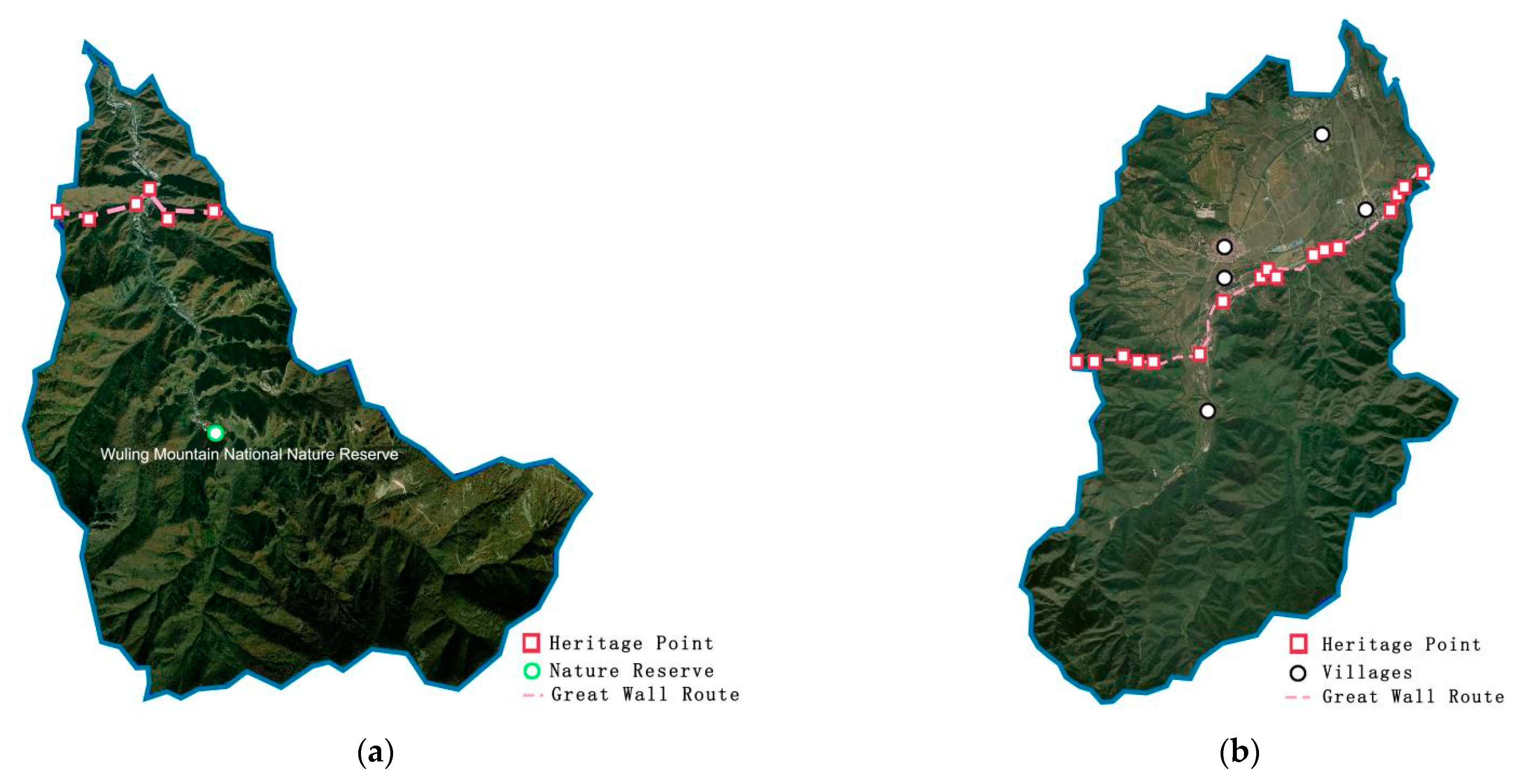
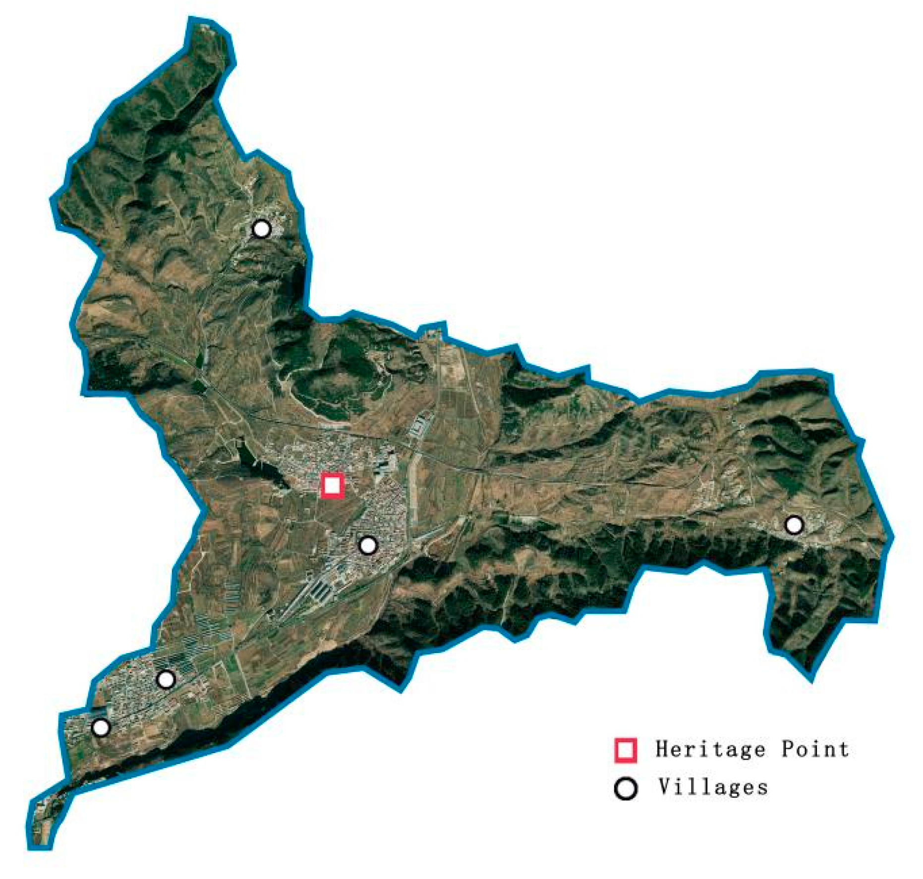
2.1. Study Area
2.2. Data Collection
2.3. Methodology of Watershed Delineation
2.4. Watershed Classification Indicator System Construction
2.5. Watershed Classification Indicator System Construction
2.5.1. Correlation Analysis
2.5.2. Cluster Analysis
3. Results
3.1. Results of the Sub-Watershed Classification of the Great Wall Cultural Zone in Beijing
3.2. Spatial Distribution Characteristics of Sub-Watershed Indicators
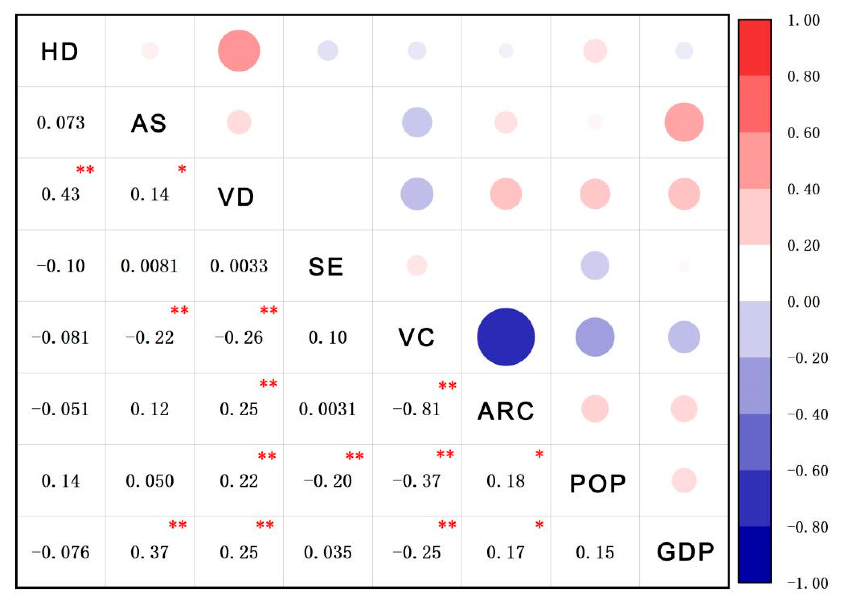
3.3. Correlation Analysis between Indicators
3.4. Types and Characteristics of Great Wall Sub-Watersheds
4. Discussion
5. Conclusions
Author Contributions
Funding
Institutional Review Board Statement
Informed Consent Statement
Data Availability Statement
Conflicts of Interest
References
- Du, Y.M.; Chen, W.W.; Cui, K.; Zhang, K.W. Study on Damage Assessment of Earthen Sites of the Ming Great Wall in Qinghai Province Based on Fuzzy-AHP and AHP-TOPSIS. Int. J. Archit. Herit. 2020, 14, 903–916. [Google Scholar] [CrossRef]
- Richards, J.; Viles, H.; Guo, Q. The importance of wind as a driver of earthen heritage deterioration in dryland environments. Geomorphology 2020, 369, 107363. [Google Scholar] [CrossRef]
- Lee, W.H.; Abdullah, S.A. Framework to develop a consolidated index model to evaluate the conservation effectiveness of protected areas. Ecol. Indic. 2019, 102, 131–144. [Google Scholar] [CrossRef]
- Davis, S.M.C. Rethinking Biodiversity Conservation Effectiveness and Evaluation in the National Protected Areas Systems of Tropical Islands: The case of Jamaica and the Dominican Repulic; Wilfrid Laurier University: Waterloo, ON, Canada, 2009. [Google Scholar]
- Watson, J.E.M.; Dudley, N.; Segan, D.B.; Hockings, M. The performance and potential of protected areas. Nature 2014, 515, 67–73. [Google Scholar] [CrossRef]
- Cao, Y.C.; Zhang, Y.K. The fractal structure of the Ming Great Wall Military Defense System: A revised horizon over the relationship between the Great Wall and the military defense settlements. J. Cult. Herit. 2018, 33, 159–169. [Google Scholar] [CrossRef]
- Wang, L. Spatial analysis of the Great Wall Ji Town military settlements in the Ming Dynasty: Research and conservation. Ann. GIS 2018, 24, 71–81. [Google Scholar] [CrossRef] [Green Version]
- Wang, C.K.; Yang, W.W.; Zhu, Y.F.; Ren, Y.J. Analysis of the impact of ancient city walls on urban landscape patterns by remote sensing. Landsc. Ecol. Eng. 2021, 17, 29–39. [Google Scholar] [CrossRef]
- Yuan, X.; LI, J.W.; LI, J.Q. Attibutes of vegetation and status of plant diversity in Great Wall Scenic-spots in Beijing. Acta Geogr. Sin. 2007, 27, 0977–0988. [Google Scholar]
- Kong, F.D. Ecological Damage Characteristics Along the Great Wall of China and Protective Measures. Res. Soil Water Conserv. 2006, 13, 42–43. [Google Scholar]
- Du, Y.M.; Chen, W.W.; Cui, K.; Gong, S.Y.; Pu, T.B.; Fu, X.L. A Model Characterizing Deterioration at Earthen Sites of the Ming Great Wall in Qinghai Province, China. Soil Mech. Found. Eng. 2017, 53, 426–434. [Google Scholar] [CrossRef]
- Du, Y.M.; Chen, W.W.; Cui, K.; Zhang, J.K.; Chen, Z.; Zhang, Q.Y. Damage Assessment of Earthen Sites of the Ming Great Wall in Qinghai Province: A Comparison between Support Vector Machine (SVM) and BP Neural Network. J. Comput. Cult. Herit. 2020, 13, 1–18. [Google Scholar] [CrossRef]
- Wang, Y.Y. Nanjing Ming City Wall Heritage Corridor Protection and Construction Research. Mater’s Thesis, Nanjing Forestry University, Beijing, China, 2015. [Google Scholar]
- Zhang, O. Research on the Distribution Status and Damage Protection of the Great Wall of Ming Dynasty in Beijing. Mater’s Thesis, Capital Normal University, Beijing, China, 2007. [Google Scholar]
- Gong, J.J.; Yang, H.; Deng, H.F. Spatial heterogeneity and complexity of forest landscape along the Ming Great Wall in Beijing. J. Beijing For. Univ. 2015, 37, 81–87. [Google Scholar] [CrossRef]
- Wei, D. Research on Conservation Planning of Yumenguan Section of Han Great Wall. Mater’s Thesis, Xi’an University of Architecture and Technology, Beijing, China, 2007. [Google Scholar]
- Tang, Y.Y.; Cai, C.; Liu, Z.W. Into Beijing Great Wall Culture Belt Protection and Development. In The Great Wall—A Collection of Essays Celebrating the 70th Anniversary of the Founding of the People’s Republic of China; The Great Wall: Beijing, China, 2019; pp. 36–41. [Google Scholar] [CrossRef]
- Lotspeich, F.B. Watersheds as the Basic Ecosystem: This Conceptual Framework Provides a Basis for a Natural Classification System. J. Am. Water Resour. Assoc. 1980, 16, 581–586. [Google Scholar] [CrossRef]
- Steiner, F.; Blair, J.; McSherry, L.; Guhathakurta, S.; Marruffo, J.; Holm, M. A watershed at a watershed: The potential for environmentally sensitive area protection in the upper San Pedro Drainage Basin (Mexico and USA). Landsc. Urban Plan. 2000, 49, 129–148. [Google Scholar] [CrossRef]
- Zhang, Y.F.; Jia, D.M.; Tan, J.; Zhang, H.Y.; Song, S.Y.; Sun, R.F. The Spatial Structure of Valley Economy Development in the Mountainous Areas of Beijing. Acta Geogr. Sin. 2009, 64, 1231–1242. [Google Scholar]
- Karen, M.O. Can Watershed Management Unite Town and Country? Soc. Nat. Resour. 2005, 18, 241–253. [Google Scholar] [CrossRef]
- FU, B.J.; XU, Y.D.; LV, Y.H. Scale Characteristics and Coupled Research of Landscape Pattern and Soil and Water Loss. Adv. Earth Sci. 2010, 25, 673–681. [Google Scholar] [CrossRef] [Green Version]
- Mayer, A.; Winkler, R.; Fry, L. Classification of watersheds into integrated social and biophysical indicators with clustering analysis. Ecol. Indic. 2014, 45, 340–349. [Google Scholar] [CrossRef]
- Shen, Y.; Su, Q.S.; Jia, T.L.; Zhou, X.D. Characteristics of the site selection and the layout of the Great Wall of the Ming dynasty from a military perspective: Xiaohekou section as an example. Front. Archit. Res. 2020, 9, 541–555. [Google Scholar] [CrossRef]
- Su, M.M.; Wall, G. Global–local relationships and governance issues at the Great Wall World Heritage Site, China. J. Sustain. Tour. 2012, 20, 1067–1086. [Google Scholar] [CrossRef]
- Chen, J.H.; Li, H.; Zhou, L.D. Gully Economy Development’s Exploration and Practice in Beijing Mountain Area. Ecol. Econ. 2010, 1, 57–62. [Google Scholar]
- Chen, T.Q.; Feng, Z.; Zhao, H.F.; Wu, K.N. Identification of ecosystem service bundles and driving factors in Beijing and its surrounding areas. Sci. Total Environ. 2020, 711, 134687. [Google Scholar] [CrossRef] [PubMed]
- Chen, D.S.; Pan, Y.Q.; Jin, X.L.; Du, H.Y.; Li, M.C.; Jiang, P.H. The delineation of ecological redline area for catchment sustainable management from the perspective of ecosystem services and social needs: A case study of the Xiangjiang watershed, China. Ecol. Indic. 2020, 121, 107130. [Google Scholar] [CrossRef]
- Wu, M.; Che, Y.; Lv, Y.P.; Yang, K. Neighbourhood-scale urban riparian ecosystem classification. Ecol. Indic. 2017, 72, 330–339. [Google Scholar] [CrossRef]
- Peng, J.; Hu, X.X.; Qiu, S.J.; Hu, Y.N.; Meersmans, J.; Liu, Y.X. Multifunctional landscapes identification and associated development zoning in mountainous area. Sci. Total Environ. 2019, 660, 765–775. [Google Scholar] [CrossRef] [PubMed] [Green Version]
- Xinliang, X. Spatial Distribution Dataset of China’s Annual Vegetation Index (NDVI). Resource and Environmental Science Data Registration and Publication System. 2018. Available online: https://www.resdc.cn/DOI/doi.aspx?DOIid=49 (accessed on 21 September 2022).
- Xinliang, X.; Chinese Population Spatial Distribution Kilometer Grid Dataset. Resource and Environmental Science Data Registration and Publication System. 2017. Available online: https://www.resdc.cn/DOI/doi.aspx?DOIid=32 (accessed on 21 September 2022).
- Fan, Y.T.; Jin, X.B.; Gan, L.; Jessup, L.H.; Pijanowski, B.C.; Yang, X.H.; Xiang, X.; Zhou, Y. Spatial identification and dynamic analysis of land use functions reveals istinct zones of multiple functions in eastern China. Sci. Total Environ. 2018, 642, 33–44. [Google Scholar] [CrossRef]
- Xinliang, X. China’s GDP Spatial Distribution Kilometer Grid Dataset. Resource and Environmental Science Data Registration and Publication System. 2017. Available online: https://www.resdc.cn/DOI/doi.aspx?DOIid=33 (accessed on 21 September 2022).
- Liang, B. Study of the method of dividing medium and large catchments into small catchments of a given size. Technol. Soil Water Conserv. 2021, 5, 12–14. [Google Scholar] [CrossRef]
- Ministry of Water Resources, PRC. Specification for Division and Coding of Small Watershed; China Water & Power Press: Devon, UK, 2013; Chapter 6. [Google Scholar]
- Zhou, Y.X.; Duan, S.H. Unit for Beijing Information System of Soil and Water Conservation—Small Watershed Division in Beijing Mountain Area. Res. Soil Water Conserv. 2004, 2, 45–46. [Google Scholar]
- Feloni, E.; Mousadis, I.; Baltas, E. Flood vulnerability assessment using a GIS-based multi-criteria approach—The case of Attica region. J. Flood Risk Manag. 2019, 13, e12563. [Google Scholar] [CrossRef] [Green Version]
- Zhang, X.Y.; Du, S.H.; Wang, Q. Integrating bottom-up classification and top-down feedback for improving urban land-cover and functional-zone mapping. Remote Sens. Environ. Interdiscip. J. 2018, 212, 231–248. [Google Scholar] [CrossRef]
- Zhang, Y.S.; Lu, X.; Liu, B.Y.; Wu, D.T.; Fu, G.; Zhao, Y.T.; Sun, P.L. Spatial relationships between ecosystem services and socioecological drivers across a large-scale region: A case study in the Yellow River Basin. Sci. Total Environ. 2020, 766, 142480. [Google Scholar] [CrossRef] [PubMed]
- Spake, R.; Lasseur, R.; Crouzat, E.; Bullock, J.M.; Lavorel, S.; Parks, K.E.; Schaafsma, M.; Bennett, E.M.; Maes, J.; Mulligan, M.; et al. Unpacking ecosystem service bundles: Towards predictive mapping of synergies and trade-offs between ecosystem services. Glob. Environ. Change 2017, 47, 37–50. [Google Scholar] [CrossRef] [Green Version]
- Peng, J.; Tian, L.; Liu, Y.X.; Zhao, M.Y.; Hu, Y.N.; Wu, J.S. Ecosystem services response to urbanization in metropolitan areas: Thresholds identification. Sci. Total Environ. 2017, 607–608, 706–714. [Google Scholar] [CrossRef]
- Mouchet, M.A.; Lamarque, P.; Martín-López, B.; Crouzat, E.; Gos, P.; Byczek, C.; Lavorel, S. An interdisciplinary methodological guide for quantifying associations between ecosystem services. Glob. Environ. Change 2014, 28, 298–308. [Google Scholar] [CrossRef]
- Safavian, S.R.; Landgrebe, D. A Survey of Decision Wee Classifier Methodology. IEEE Trans. Syst. Man Cybern. 1991, 21, 660–674. [Google Scholar] [CrossRef] [Green Version]
- Ertuğrul, Ö.F.; Tağluk, M.E. A Novel Version of k Nearest Neighbor: Dependent Nearest Neighbor. Appl. Soft Comput. 2017, 55, 480–490. [Google Scholar] [CrossRef]
- Aggarwal, C.C.; Zhai, C. A Survey of Text Classification Algorithms. In Mining Text Data; Springer: Boston, MA, USA, 2012; Chapter 6; pp. 163–222. [Google Scholar] [CrossRef] [Green Version]
- Capó, M.; Pére, A.; Lozano, J.A. An efficient approximation to the k-means clustering for massive data. Knowl.-Based Syst. 2017, 117, 56–69. [Google Scholar] [CrossRef] [Green Version]
- Jiao, Y.M.; Zhao, D.M.; Ding, Y.P.; Liu, Y.; Xu, Q.; Qiu, Y.; Liu, C.; Liu, Z.L.; Zha, Z.Q.; Li, R. Performance evaluation for four GIS-based models purposed to predict and map landslide susceptibility: A case study at a World Heritage site in Southwest China. CATENA 2019, 183, 104221. [Google Scholar] [CrossRef]
- Battis-Schinker, E.; Al-Alawi, S.; Knippschild, R.; Gmur, K.; Belof, M. Towards quality of life indicators for historic urban landscapes—Insight into a German-Polish research project. Environ. Sustain. Indic. 2021, 10, 100094. [Google Scholar] [CrossRef]
- Cano, M.; Garzón, E.; Sánchez-Soto, P.J. Historic preservation, GIS, & rural development: The case of Almería province, Spain. Appl. Geogr. 2013, 42, 34–47. [Google Scholar] [CrossRef]
- Stanganelli, M.; Torrieri, F.; Gerundo, C.; Rossitti, M. An integrated strategic-performative planning methodology towards enhancing the sustainable decisional regeneration of fragile territories. Sustain. Cities Soc. 2019, 53, 101920. [Google Scholar] [CrossRef]
- Wang, H. Environmental problems in the exploitation and management of the farmhouse enjoyment and their solving ways. J. Anhui Agric. Sci. 2008, 36, 10081–10082. [Google Scholar] [CrossRef]
- Seduikyte, L.; Grazuleviciute-Vileniske, I.; Kvasova, O.; Strasinskaite, E. Knowledge transfer in sustainable management of heritage buildings. Case of Lithuania and Cyprus. Sustain. Cities Soc. 2018, 40, 66–74. [Google Scholar] [CrossRef]
- Su, M.M.; Wall, G. Community involvement at Great Wall World Heritage sites, Beijing, China. Curr. Issues Tour. 2013, 18, 137–157. [Google Scholar] [CrossRef]
- Schirpke, U.; Scolozzi, R.; Dean, G.; Haller, A.; Jäger, H.; Kister, J.; Kovács, B.; Sarmiento, F.O.; Sattler, B.; Schleyer, C. Cultural ecosystem services in mountain regions: Conceptualising conflicts among users and limitations of use. Ecosyst. Serv. 2020, 46, 101210. [Google Scholar] [CrossRef]
- Nicu, I.C. Frequency ratio and GIS-based evaluation of landslide susceptibility applied to cultural heritage assessment. J. Cult. Herit. 2017, 28, 172–176. [Google Scholar] [CrossRef]
- Wu, T.M. Discussion on sewage treatment method in mountain scenic area. Shanxi Architec. 2007, 35, 207–208. [Google Scholar]
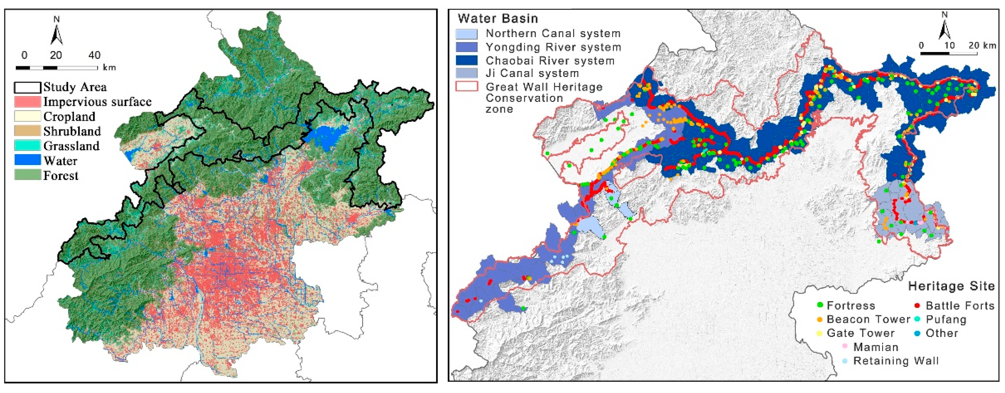

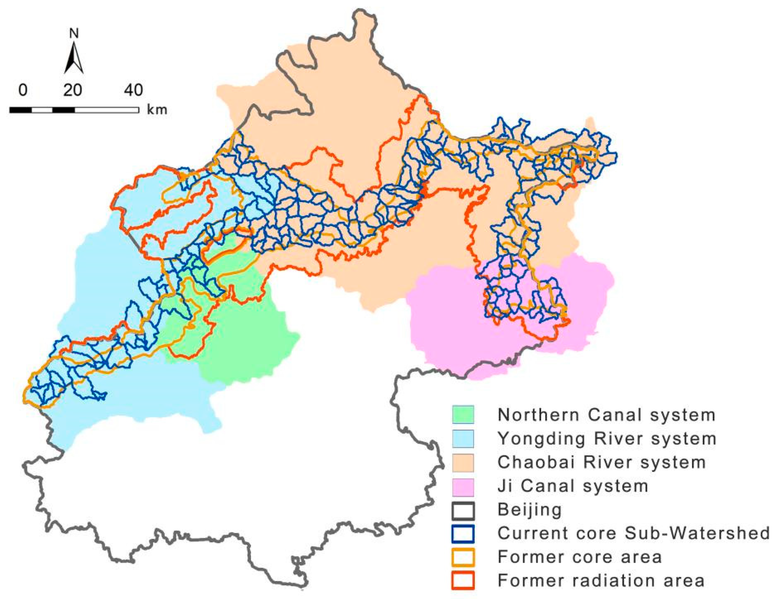
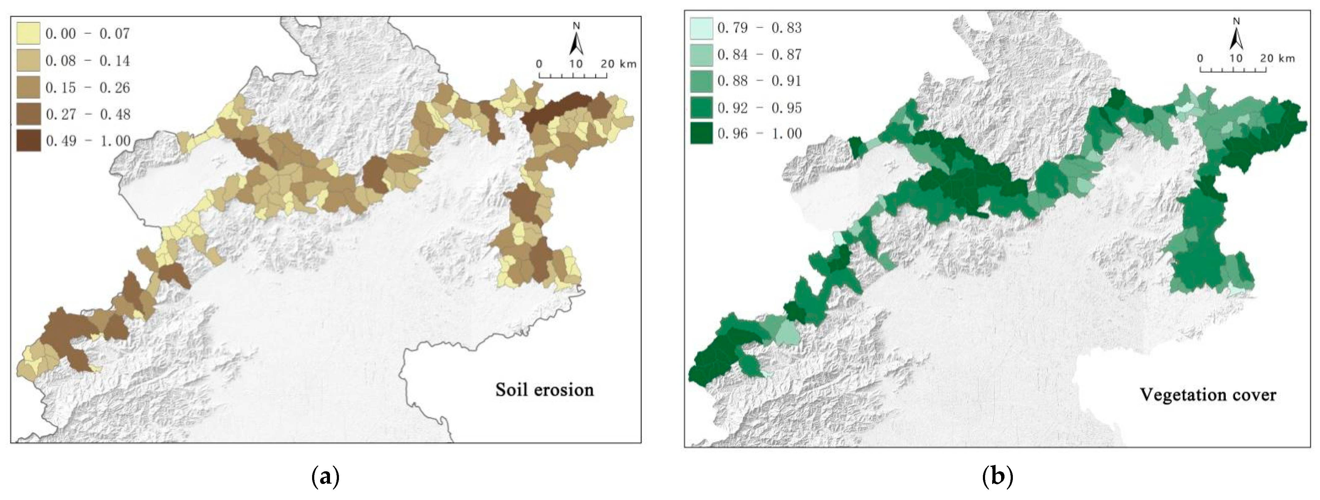
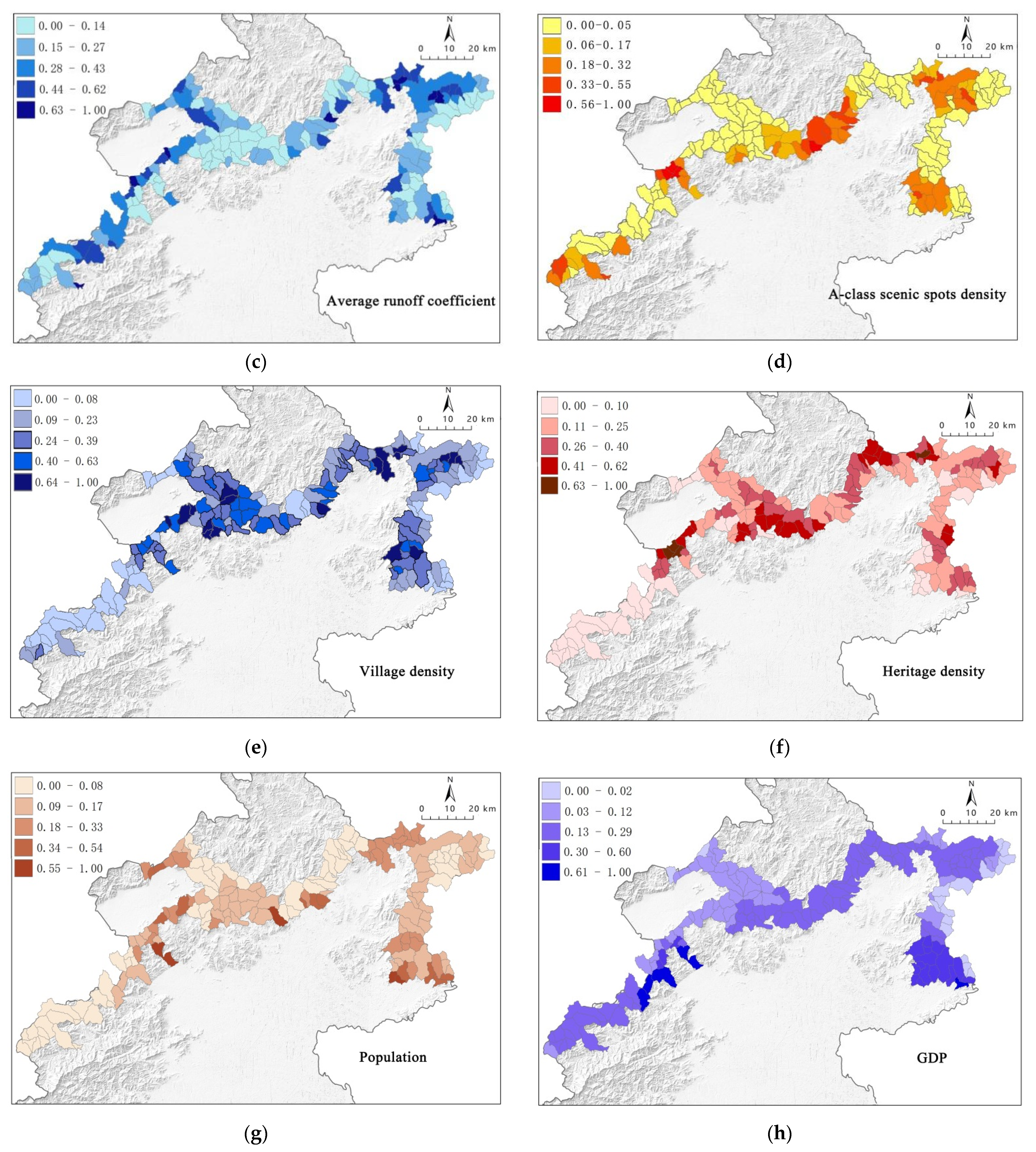


| Indicator Type | Indicator | Calculation Method | Explanation | References and Data Source |
|---|---|---|---|---|
| 1. Heritage Attributes | 1.1. Great Wall heritage density | Calculations through the heritage (heritage/km2) | Reflecting the distribution of heritage resources in the watershed, the more heritage sites there are, the more prominent the heritage attributes. | [27] (http://www.ilovegreatwall.cn/public/TheGoogleGreatWall/ (accessed on 21 September 2022)) |
| 2. Ecological Attributes | 2.1. Degree of soil erosion | USLE (universal soil loss equation) (km2·a) | Reflecting the intensity of soil erosion in the watershed, the greater the soil erosion, the greater the ecological sensitivity. | [28,29] (http://www.ecosystem.csdb.cn, accessed on 21 September 2022) |
| 2.2. Degree of vegetation cover | Estimation of vegetation cover from NDVI (%) | The vegetation growth status can influence the quantity and quality of ecosystem services [30]. The higher the vegetation cover, the better the ecological functions. | [30,31] (http://www.resdc.cn/, accessed on 21 September 2022) | |
| 3. Social Attributes | 3.1. Population density | Population per square kilometer (inhabitants/km2) | Population distribution is an important indicator; higher population densities are associated with higher levels of villagization and more human activities. | [32,33] (http://www.resdc.cn/, accessed on 21 September 2022) |
| 3.2. GDP | GDP value per square kilometer (million/km2) | An essential indicator of the gross domestic value of a watershed’s economy, the higher the GDP value, the better the economic development. | [33,34] (http://www.resdc. cn/, accessed on 21 September 2022) | |
| 3.3. Village density | Number of villages per square kilometer (village/km2) | Reflecting the distribution of villages in the catchment, the higher the density of villages, the richer the human activity and disturbance. | (National Bureau of Statistics) | |
| 3.4. A-class scenic spots density | Data from the 2020 list of A-class scenic spots obtained from the Ministry of Culture and Tourism of the People’s Republic of China was crawled through the Baidu API for the longitude and latitude. Number of A-class attractions per square kilometer (Scenic Area/km2) | The Great Wall heritages are located in valleys, where numerous tourist attractions are developed, representing the cultural services provided by the heritages and ecosystems. The higher the density of tourist attractions, the more developed the tertiary sector. | [27,33] (https://www.mct.gov.cn/, accessed on 21 September 2022) | |
| 4. Hydrological Attributes | 4.1. Average runoff coefficient | Multiplying the land use of each catchment by the corresponding runoff coefficient and making a weighted average | The runoff coefficient reflects the catchment’s land cover, building density, and soil characteristics and is significant for watershed classification. The higher the average runoff coefficient of the watershed, the higher the surface runoff yield. | [28,29] |
| Clustering | Error | |||||
|---|---|---|---|---|---|---|
| Mean Square | Degree of Freedom | Mean Square | Degree of Freedom | F | Significance | |
| Soil erosion | 0.072 | 4 | 0.012 | 164 | 6.194 | 0.000 |
| Vegetation coverage | 0.030 | 4 | 0.001 | 164 | 28.023 | 0.000 |
| Average runoff coefficient | 0.785 | 4 | 0.024 | 164 | 32.723 | 0.000 |
| Heritage density | 0.575 | 4 | 0.021 | 164 | 26.782 | 0.000 |
| Village density | 1.732 | 4 | 0.019 | 164 | 89.904 | 0.000 |
| A-class scenic spot density | 0.523 | 4 | 0.023 | 164 | 23.004 | 0.000 |
| GDP | 0.763 | 4 | 0.014 | 164 | 53.354 | 0.000 |
| Population | 0.370 | 4 | 0.017 | 164 | 21.187 | 0.000 |
| Category | Number in Each Category (Fraction of Total) | Description | |
|---|---|---|---|
| High Attributes | Low Attributes | ||
| 1. Heritage + Ecology | 76 (45%) | Vegetation coverage, Heritage density | Population, GDP, Soil erosion, A-class scenic spot density |
| 2. Heritage + Village | 44 (26%) | Heritage density, Village density, Average runoff coefficient | — |
| 3. Heritage + Tourism | 8 (4.7%) | Average runoff coefficient, Heritage density, A-class scenic spot density, Village density | Soil erosion |
| 4. Ecological Protection | 29 (17.2%) | Soil erosion, Average runoff coefficient | Heritage density, GDP, Population |
| 5. Rural Economy | 12 (7.1%) | Population, GDP | Heritage density, A-class scenic spots density |
Publisher’s Note: MDPI stays neutral with regard to jurisdictional claims in published maps and institutional affiliations. |
© 2022 by the authors. Licensee MDPI, Basel, Switzerland. This article is an open access article distributed under the terms and conditions of the Creative Commons Attribution (CC BY) license (https://creativecommons.org/licenses/by/4.0/).
Share and Cite
Jiang, L.; Wang, S.; Sun, Z.; Chen, C.; Zhao, Y.; Su, Y.; Kou, Y. Spatial Delineation for Great Wall Zone at Sub-Watershed Scale: A Coupled Ecological and Heritage Perspective. Sustainability 2022, 14, 13836. https://doi.org/10.3390/su142113836
Jiang L, Wang S, Sun Z, Chen C, Zhao Y, Su Y, Kou Y. Spatial Delineation for Great Wall Zone at Sub-Watershed Scale: A Coupled Ecological and Heritage Perspective. Sustainability. 2022; 14(21):13836. https://doi.org/10.3390/su142113836
Chicago/Turabian StyleJiang, Linping, Sisi Wang, Zhe Sun, Chundi Chen, Yingli Zhao, Yi Su, and Yingying Kou. 2022. "Spatial Delineation for Great Wall Zone at Sub-Watershed Scale: A Coupled Ecological and Heritage Perspective" Sustainability 14, no. 21: 13836. https://doi.org/10.3390/su142113836
APA StyleJiang, L., Wang, S., Sun, Z., Chen, C., Zhao, Y., Su, Y., & Kou, Y. (2022). Spatial Delineation for Great Wall Zone at Sub-Watershed Scale: A Coupled Ecological and Heritage Perspective. Sustainability, 14(21), 13836. https://doi.org/10.3390/su142113836


