Article

The Classification and Regulation of Mountain Villages in the Context of Rural Revitalization—The Example of Zhaotong, Yunnan Province

1
Institute of Geographical Sciences and Natural Resources Research, Chinese Academy of Sciences, Beijing 100101, China
2
College of Resources and Environment, University of Chinese Academy of Sciences, Beijing 100049, China
3
Qiqihar Branch of Heilongjiang Academy of Agricultural Sciences, Qiqihar 161006, China
*
Author to whom correspondence should be addressed.
Sustainability 2022, 14(18), 11381; https://doi.org/10.3390/su141811381
Submission received: 24 July 2022 / Revised: 5 September 2022 / Accepted: 5 September 2022 / Published: 10 September 2022
(This article belongs to the Section Sustainable Urban and Rural Development)

Abstract

:
Village classification schemes and development strategies have important theoretical and practical significance for realizing rural revitalization. Mountainous villages account for a large proportion of China’s rural areas, which is a challenge to rural revitalization. This study takes the mountainous region of Zhaotong, Yunnan Province, and the “National Strategic Plan for Rural Revitalization (2018–2022)” to construct an evaluative index of village development potential and a village classification model, and proposes regulation strategies and the classification and stratification public service configuration scheme for different types of village. The research results show that (1) when evaluating development potential, terrain factors such as slope and geological hazards should be included; (2) the distribution of development potential in Zhaotong has obvious heterogeneity; (3) villages in Zhaotong are divided into five types for development: agglomeration and upgrading, suburban integrated, relocated and merged, characteristic conservation, and temporarily ambiguous types; and (4) the order of greatest to least number of village types is agglomeration and upgrading > suburban integrated > relocated and merged > temporarily ambiguous > characteristic conservation. The agglomeration and upgrading, relocated and merged, and suburban integrated types are relatively concentrated spatially. The characteristic conservation and temporarily ambiguous types are more scattered. Based on the above research results, it is suggested that villages be renovated and public service facilities be configured on different levels, according to the characteristics of different village types. During renovation, special emphasis is placed on preserving the original style of the village and protecting and respecting the will of the villagers. The strategy for developing village infrastructure and public service facilities should be dynamically adjusted according to village type.

1. Introduction

Villages are the backup force for urban construction and an inseparable part of social progress and national development. Urbanization in rural areas has always been the focus of scholars in both developed and developing countries. In 1982, Leo Van Den Berg et al. proposed the famous spatial-cycle model (SCM) from the perspective of resource factor flow, indicating the urban development stages of urbanization, suburbanization, desurbanization and re-urbanization [1]. On this basis, Chinese scholars summarized the development process of urbanization in the world, and from the perspective of urban-rural relationship, put forward the transformation process of urban-rural differentiation, urban-rural separation, urban-rural opposition, urban-rural composition and urban-rural integration [2]. In the process of industrialization, the dual urban-rural system of emphasizing cities over rural areas has made the gap between urban and rural development continue to widen in China. According to research, since 2000, China’s rural areas have undergone widespread and drastic changes, the coordination of development between urban and rural areas has dropped significantly, and a large number of villagers have flocked to cities. A series of “rural diseases”, such as the hollowing of infrastructure and agricultural marginalization, have been identified [2,3,4,5].
In fact, both developed and developing countries have faced or are facing problems such as rural depopulation and rural decline, and have explored solutions suitable for their own development [6], such as research into the construction of small rural towns in the United States, the village-building movement in Japan, the new village movement in South Korea, etc. [7,8,9]. However, the experience of other countries can only provide a reference for China to deal with urban and rural problems, which is not completely suitable for China’s national conditions. In the context of the urgency of solving urban-rural problems and the uniqueness of China’s situation, China formally proposed the Rural Revitalization Strategy (RRS) in 2018. It includes five aspects of industrial revitalization, talent revitalization, cultural revitalization, ecological revitalization and organizational revitalization in rural areas, aiming to solve the imbalance between urban and rural development, curb rural decline, revitalize villages, and promote the comprehensive rejuvenation of rural areas [4]. The rural revitalization strategy is based on the theory of sustainable development and the man-land relationship regional system [8], and emphasizes the sustainable development of rural economy, politics, culture, society and ecology as well as the interactive, inseparable and co-developing relationship between urban and rural areas. It is a characteristic strategy that conforms to China’s national conditions after summarizing its historical experience. What needs to be made clear is that rural revitalization does not mean stopping urbanization, but breaking the dual urban-rural system and advancing the urban-rural relationship in a scientific way.
In recent years, with the process of urbanization and industrialization, the heterogeneity of resource endowment, location conditions, scale, and form between villages in the same region has gradually become prominent. The difference between rural regional systems has become the main basis for village development, and a single policy or a specific development model is no longer suitable for rural development [10,11]. The classification of villages has become the focus of scholars’ attention. Globally, typology is often used as the basis for the classification of villages, and the OECD first attempted to create a typology of rural areas [12]. Typology aims to delineate or define rural areas and is increasingly used by scholars to identify and explain the heterogeneity of rural areas for better planning [13]. In 2018, the Central Committee of the Communist Party of China and the State Council issued the “National Strategic Plan for Rural Revitalization (2018–2022)” (hereafter referred to as the “Plan”). The “Plan” summarizes the experience of China’s rural reform and poverty reduction process, and from the perspective of the differences in rural regional systems, proposes to divide villages into suburban integrated villages, agglomeration and upgrading villages, characteristic conservation villages, and relocated and merged villages, so as to promote rural development by classification. Suburban integrated villages emphasize the clustering of villages into cities, which is the key to breaking the dual urban-rural structure and realizing urban-rural integration. Agglomeration and the upgrading of villages are the focus of rural revitalization, and its setting is the extension of the growth pole theory. Such villages are regarded as the spatial center of rural growth, and the spatial layout of village agglomeration is also an important condition for minimizing cost and maximizing profit. Characteristic conservation villages are important carriers of nature, history and traditional culture. The setting of such villages conforms to the “Convention Concerning the Protection of the World Cultural and Natural Heritage”, and confirms the cultural value contained in villages. Relocated and merged villages take into account the most basic human right to life. When natural disasters occur frequently and endanger human life, they should be moved out of the area immediately. The village is also set up on the basis of spatial agglomeration and cost minimization. It is relocated to the nearby large village settlement to avoid decentralized village development and resource allocation. In conclusion, China’s village classification has a rich history and a reliable theoretical basis, but the classification method is not mentioned in the “Plan”. Therefore, it is very important for the sustainable development of rural areas to explore the methods of village classification and put forward the classification remediation strategies.
At present, scholars have launched a series of discussions on the classification and remediation of villages. Research on rural areas in developed countries occurred elsewhere before in China, mainly to solve the problems of rapid urban expansion and the influx of rural resources into urban areas [14,15]. In terms of village classification, Christaller proposed central place theory after researching German villages, arguing that villages have different levels of development and different spatial distributions [16]. With the development of society, more complex village development problems appear. The traditional qualitative method of rural typology relying on experience is no longer applicable, and the quantitative method of rural typology has become the focus of scholars [17]. Scholars often use a series of decomposition and induction methods to study village classification on the basis of identifying natural resources, human resources, social economy and other attributes [18,19,20,21]. For example, John R. Blunden et al. divided the village into five categories, including urban imprint zone, high amenity and advantaged areas and so on, from the aspects of accessibility, settlement, population, socio-economic profile and telematics systems, and through the establishment of an artificial neural network model to identify the rural areas of EU countries [22]. It also provides an effective and convenient technical means for the subsequent quantitative research on village classification. Aleksandra Gajić et al. established a classification framework from the potential and the limitations of rural areas. Using the method of principal component analysis and cluster analysis, Serbia was divided into six regions, which created the conditions for the formulation and implementation of spatial planning in rural areas [23]. Based on the analysis of Diday dynamic cloud clustering, Monika Stanny et al. divided the rural areas of Poland into seven types of units, including traditional agriculture, large-scale agriculture and so on, and explored the diversity of different types of rural areas and the heterogeneity of socio-economic development in Poland [24]. Chinese research on villages mainly focuses on rural revitalization, village classification, evaluation of village development potential, rural land consolidation, etc. [25,26,27,28,29,30]. Especially after the “Plan” clarified the types of villages, different classification schemes were proposed, based on these. For example, Feng Danyue and others considered the rural revitalization strategy and the development requirements of villages, and used the Pajek complex network analysis method to construct the village hierarchy system. They also provide theoretical and data reference for the classification and consolidation of villages [31]. Li Y et al. first proposed the village classification model (VCM). The qualitative classification of villages by means of filter screens provided an effective way for the development of village classification methods in China [32]. Overall, rich classification indicators and diverse classification methods provide a solid foundation for the development of this paper. However, the current research methods are mostly single quantitative or qualitative methods, and because the “Plan” is not clear regarding a classification scheme, scholars are still exploring the classification methods of village types involved in the “Plan”. It has the certain research blank.
During development, the problems of mountain villages, compared with those of villages in flat areas, are more prominent. Mountain villages are affected by the energy gradient, surface fragmentation, and other natural attributes of the mountains [33], and the phenomenon of empty village settlements is common. In mountain villages, farmers have inconvenient transportation, high investment in infrastructure and public service facilities, and difficulty with remediation, which are key areas for sustainable rural development. Globally, mountains are widely distributed in Eurasia and the Americas [34], and China’s mountainous area accounts for nearly 70% of the country’s total land area. According to the “China Counties Statistical Yearbook (County and Cities Volume)”, when more than 80% of the area in a county is mountainous, the county is defined as mountainous, and the total area of China occupied by mountainous counties is approximately 45% [35]. As an important part of China’s rural areas, mountainous villages are relatively underdeveloped socioeconomically. Solving the problems of remediation and development of such villages plays a pivotal role in China’s rural revitalization strategy. Therefore, against the background of rural revitalization, studying the cost-effective and efficient classification and remediation strategy of mountain villages is of practical significance.
Based on scholarly research and considering the particularity of mountain villages, this paper establishes an evaluation index of village development potential and a village classification model with regional characteristics. It proposes a targeted rectification strategy, and a hierarchical plan to configure public service facilities to provide a systematic basis for wisely classifying villages and promoting rural development and revitalization.

2. Materials and Methods

2.1. Overview of the Study Area

Zhaotong is located in the northeastern part of Yunnan Province, on the right bank of the lower reaches of the Jinsha River, in the remote area of the Wumeng Mountains at the junction of Yunnan, Guizhou and Sichuan Provinces, and in the transition zone from the Sichuan Basin to the uplift of the Yunnan-Guizhou Plateau. It has jurisdiction over 11 counties and cities. The total land area of Zhaotong is approximately 23,000 square kilometers. In 2018, the developed land area was 19,509 square kilometers, accounting for 84.74% of the total land area of the city. Agricultural land, at 18,795 square kilometers, accounts for 96.34% of developed land. The amount of land with architectural structures is 714 square kilometers, accounting for 3.66% of developed land. Zhaotong is located on the Yunnan-Guizhou Plateau, and the elevation is high in the southwest and low in the northeast, which is typical of mountainous terrain for the region. Although its territory has many mountains and little flat land, the total population is large. The population density of Zhaotong is higher than the average level of Yunnan Province and the whole country, and the population distribution is not balanced.
In recent years, in combination with the national new urbanization development strategy, Zhaotong has continuously strengthened the integrated development of urban and rural areas and continued to improve rural people’s livelihood, infrastructure, and the ecological environment. However, rural shortcomings are still prominent. The main problem is the contradiction between terrain and development. According to scholarly research, Zhaotong is a mountainous county [35], and the villages are typical mountain villages. Restricted by the terrain, the layout of the villages is scattered, and the cost of public services is high, making it difficult to develop. Therefore, this paper chose Zhaotong City as the research area and takes its 1619 administrative villages as the research object, in an attempt to provide reference for the classification and improvement of villages in mountainous areas and the optimization of village layout (Figure 1).

2.2. Data Sources

The data covered in this paper mainly include nighttime light remote sensing data, various land use data, geological disaster data, DEM data, earthquake data, POI data, administrative division data at all levels and other geographic information data. The NPP/VIIRS night light remote sensing data come from the academic department of Corolla University of Mines (https://payneinstitute.mines.edu/eog/) (accessed on 15 March 2022), which has been widely used in various studies [36] and was resampled to 30 m in this study. All kinds of land use data, including urban development boundaries, ecological protection zones, industrial land, urban and village roads, etc., as well as historical records of geological disasters and administrative divisions at all levels are all from the land and resources department. DEM data come from NASA (https://earthdata.nasa.gov/esds/competitive-programs/measures/nasadem) (accessed on 15 March 2022) and have been used in previous research [37]. The population density data come from Worldpop, the time node is 2018, and the resampling was 30 m in this study. The seismic data come from the National Earthquake Science Data Center, and the time and regional scope includes all earthquakes that have occurred in Yunnan Province since 2010. The POI data come from the Resource and Environmental Science Data Center of the Chinese Academy of Sciences, and the time node is 2018. The specific parameters of the data are shown in Table 1.

2.3. Research Method

2.3.1. Evaluation of Village Development Potential Based on AHP

The construction of the village development potential index system is to select the indicators related to the village development and reflect the future development ability, and summarize them, which is an important part of evaluating the village development potential. Scholars have carried out studies on this. For example, Wei Lin et al. constructed an index system from five aspects, location conditions, village scale, economic development, service facilities and concentration degree, to measure the development potential of villages [38]. Rosa Cuesta Molestina et al. classified the development of villages based on population, urbanization rate, economically active population and distance to regionally important cities [21].
Through a review of the literature, scholars selected evaluation indicators for village development potential mainly from the three aspects of village location conditions, social and economic development level, and the completeness of public service facilities. Some studies set personalized indicators based on the evaluation purpose. In this paper, the evaluation of village development potential is to use quantitative methods to assist the classification of villages, so the index system is only constructed for the three types of villages involved in the “Plan”: suburban integrated villages, agglomeration and upgrading villages, and relocated and merged villages. In order to protect historical and cultural relics, develop tourist resources and preserve traditional ethnic culture, villages with a distinctive natural history and cultural characteristics, such as famous historical and cultural villages, ethnic minority characteristic villages, and famous scenic tourist villages, are directly classified as characteristic conservation villages according to the national or local published lists. The development potential of villages has little impact on the classification of such villages, and historical culture, tourist resources and other related cultural background and resource endowment indexes will not be added into this evaluation index system.
By comprehensively considering the above conditions, following the principles of methodical, complete and feasible index selection, and combining with the research and the actual situation of mountainous villages in Zhaotong, the evaluation index system of village development potential is constructed in this paper, as shown in Table 2. The index system includes six aspects: socioeconomic scale, industry dependence, local condition, completeness of public service facilities, degree of disaster impact and land suitability.
The socioeconomic scale reflects the social and economic development status of the village, and is represented by population density and the level of economic development. The larger the scale of the social economy, the greater the attractiveness of the village for the population and the economy, and the greater the potential for social and economic development. Industry dependence refers to the dependence of a village on a certain industry and is expressed by the ratio of the land area of the industry to the area of homesteads in the village. The high dependence of villages on this industry indicates that this industry has a good foundation for development and has greater potential for future development. The local conditions are key to village development, which is represented by the distance from village to the nearest town development boundary, the distance from village to the nearest highway and the nearest town village road. Villages with a superior location have more opportunities to connect and communicate with the outside world. The completeness of public service facilities refers to conveniences for living and learning, which is represented by the number of kindergartens, primary and secondary schools, hospitals and health stations in the village. Convenient service facilities can attract villagers to settle down, which is a favorable condition for village development. The degree of disaster impact is a factor set according to the actual situation of frequent disasters in Zhaotong and is an important aspect of the evaluation of village development potential. It is described by the number of geological disasters and the number of earthquakes that occur in the village in a given time period. Villages with more disasters have a relatively poor development foundation and need to determine the response measures according to the actual situation. Land suitability is the basic condition of village development, which is expressed by village average slope and village average elevation. The villages with relatively steep terrain have some difficulties in transportation development, public facilities configuration and villagers’ production and life, and the development potential is relatively small.
To eliminate the difference in results caused by different indicator units and data ranges, this paper standardizes the indicators before calculating development potential and uses the extreme value method [39] to make the value range of each indicator between 0 and 1. The specific formula is as follows:
Positive   indicator :   x i j = x i j x i , m i n x i , m a x x i , m i n ,
Negative   indicator :   x i j = x i j x i , m i n x i , m a x x i , m i n ,
where x i j is the value of the i th indicator in the j th village before the standardization, x i , m a x and x i , m i n are the maximum and minimum values of the i th indicator, respectively, and x i j is the normalized value of the i th indicator in the   j th village.
Because the selection of indicators is more complex and diverse, this paper selects AHP (Analytic Hierarchy Process) to calculate the weight of each indicator. AHP is a decision theory proposed by Saaty in the 1970s [40]. It can hierarchically classify and prioritize complex and disordered problems through relative metrics and pairwise comparisons. It is a systematic method that combines qualitative and quantitative methods and is widely used by scholars to assign power to indicator systems [41,42,43]. By comparing the pairwise importance of the factor layer and the index layer corresponding to each factor, a judgement matrix is constructed, and the weight of each index and each factor is finally obtained (Table 2). Each judgement matrix passed the consistency test.
In order to observe and analyze the development potential of villages more intuitively, this paper uses the natural breaks (Jenks) method to divide villages into four levels according to their development potential value. Natural breaks is a common method in statistics. It is based on the natural distribution law of data and identifies the classification interval, so as to minimize the intra-class difference and maximize the inter-class difference. It is a relatively objective classification method and widely used by scholars [44,45,46,47].

2.3.2. Classification of Villages Based on Village Development Potential and VCM

According to the development status, location conditions, and resource endowments of different villages, the “National Strategic Plan for Rural Revitalization (2018–2022)” promotes the development of villages by a classification system with four different categories: suburban integrated villages, agglomeration and upgrading villages, characteristic conservation villages, and relocated and merged villages. On this basis, combined with the development potential of villages, this study constructed a village classification model (VCM) for Zhaotong [32]. The unique attributes and potential values of each village are put into the model and stratified by filters to determine the type to which it belongs.
On the basis of the description of the four types in the “Plan” and combined with the actual situation in Zhaotong, the study further clarifies the definition of four types of villages in the “Plan”. “Suburban integrated” refers to villages that are close to towns and have the potential to develop into the towns. In the study, they are defined as villages that intersect with urban development boundaries. The “agglomeration and upgrading” type refers to existing large-scale villages and other villages with better infrastructure for transportation, industrial development, facilities and general development prospects. This category accounts for the majority of the villages, defined in the study as villages with a development potential value above the 1/4 quantile. The “characteristic conservation” type is a village with beautiful natural scenery, profound cultural heritage and diverse ethnic customs. In the “Plan” and literature [32], they are defined as famous historical and cultural villages at all levels, traditional villages, ethnic minority villages and famous scenic tourist destinations. The “relocated and merged” type includes villages with poor living conditions and fragile ecological environments. Considering the frequent occurrence of natural disasters in Zhaotong, geological disasters and earthquakes have been included in the evaluation indicators for village potential, and the weights are relatively large. These villages are defined in the study as nature reserves, forest farms, mining areas, farms, and villages with potential values less than the first natural breakpoint threshold. Considering that the characteristics and development direction of some villages have not been clearly defined and cannot be classified into any one of the above four types for the time being, this study adds a category of temporarily ambiguous type to the village types proposed in the “Plan”.
At the same time, because the characteristic conservation villages contain mostly cultural relics, historical buildings, etc., their importance is strong, the overall number is small, and assessment is easy, so their priority is ranked first. The relocated and merged villages have poor resource endowments affecting the normal production and life of villagers, and the bottom line of village development is threatened, making them the second priority. Suburban integrated villages radiate from towns and have greater development potential, so they are regarded as the third priority. The agglomeration and upgrading villages are the fourth priority. Villages that do not meet the above four criteria are classified as temporarily undefined. The village classification model of Zhaotong is shown in Figure 2.
With the continuous development of the village’s social economy and traffic conditions, the distribution of factors in the village is also constantly concentrated and transition to agglomeration distribution. From the perspective of village development and cost-effectiveness, the decentralized distribution of public service facilities and infrastructure is no longer suitable for village construction. In view of this, this paper proposes the hierarchical allocation of public service facilities and infrastructure. In this paper, each type of village is divided into three levels: central village, grassroots village and scattered households. A central village refers to an area with relatively large remediation potential and relatively concentrated distribution of people and services for its development category. Grassroots villages are natural villages with relatively small remediation potential, which are distributed around the central village. Scattered households are far away from both the central village and grassroots villages, distributed independently, and basically do not have remediation potential. For all types of village, the number of central villages is the largest, followed by grassroots villages, and the number of scattered households is the lowest.

3. Results

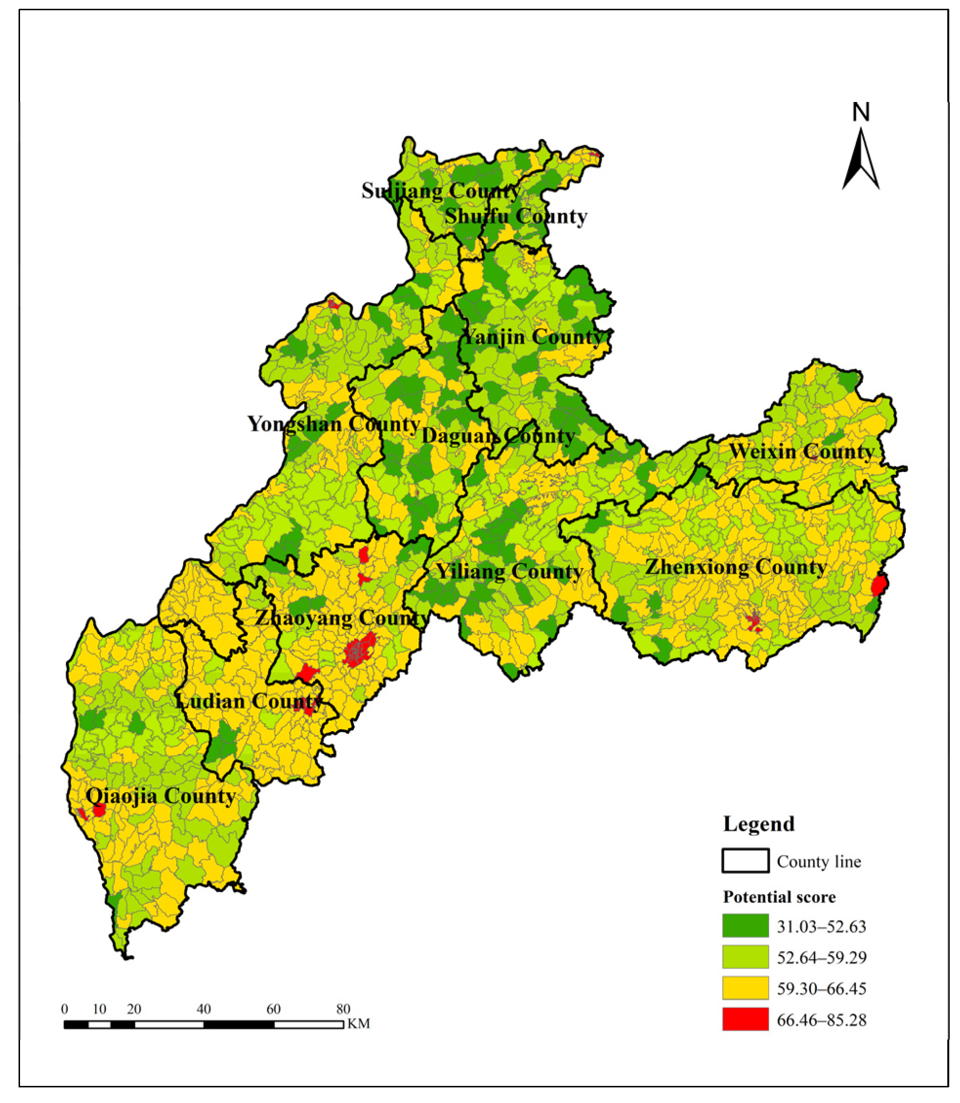
3.1. Analysis of Village Development Potential

According to the evaluation index of village development potential and the weight of each factor obtained by AHP, the village development potential score can be calculated. Figure 3 maps the spatial distribution of the development potential of each village in Zhaotong, which is divided into four categories according to the potential score using the natural breakpoint method in ArcGIS 10.2. The average development potential of villages in Zhaotong is 59.35, the development potential of most villages is between 53.94–64.66, and the overall development potential needs to be improved. The village with the lowest development potential is Gaoqiao Village Committee, Gaoqiao Town, Daguan County. Due to frequent geological disasters, its potential score is only 31.03. The village with the highest development potential is the Wenwei Community in Zhenxiong County, with a large population and economic scale and neither geological disasters nor earthquakes, with a potential score of 85.28.
In addition, the spatial heterogeneity of the development potential of each village in Zhaotong is obvious. The potential in the northern and central counties is relatively low, and the potential in the eastern and western counties is relatively high, especially in Zhaoyang District. This is related to the location of the village and the frequency of natural disasters. As the political, economic and cultural activity center of Zhaotong, Zhaoyang District has a superior geographical location and a high level of economic development, and the villages under its jurisdiction have naturally high development potential. However, ecologically fragile areas and other extremely important areas for ecological protection in the northern and central parts of Zhaotong account for a large proportion of the area, and natural disasters are relatively frequent. At the same time, the northern counties are far from the downtown area of Zhaotong and are not easily affected by the radiation of development from the central area. Therefore, the development potential of the villages under its jurisdiction is generally not high.

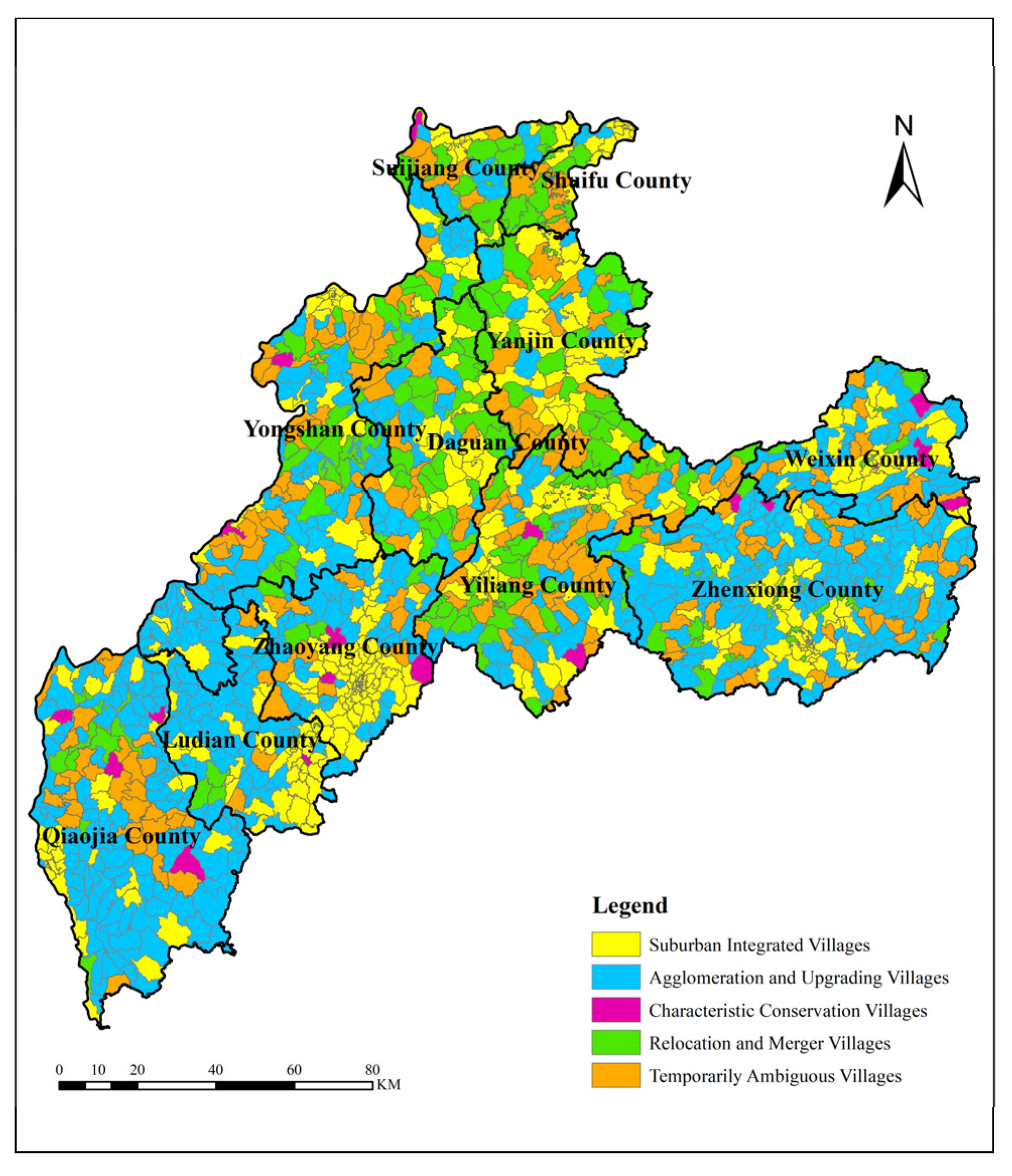
3.2. Analysis of Village Classification Result

Combined with the “National Strategic Plan for Rural Revitalization (2018–2022)”, according to the village development potential and village classification model, this paper classified villages into five types: suburban integrated, agglomeration and upgrading, characteristic conservation, relocated and merged and temporarily ambiguous. The classification results of villages divided into administrative villages are shown in Figure 4. There are 446 suburban integrated villages, 570 agglomeration and upgrading villages, 362 relocated and merged villages, 21 characteristic conservation villages and 220 temporarily ambiguous villages in Zhaotong. The classification results are consistent with the actual situation of the villages. In addition, the remaining rural homesteads within the ecological protection zones need to be relocated and merged. The distribution of village types is pyramidal. That is, from more to less, they rank as agglomeration and upgrading > suburban integrated > relocated and merged > temporarily ambiguous > characteristic conservation. As a key area of rural development and rural revitalization, the number of agglomeration and upgrading villages is the largest, which is in line with the requirements of the plan. The characteristic conservation villages must have specific cultural or landscape characteristics, so their number is the lowest.
In terms of spatial distribution, suburban integrated villages are distributed in a concentrated and contiguous manner, and most of them are adjacent to or located within the county seat of Chengguan. There are relatively few natural disasters within the range of urban influence, and the layout of public service facilities is relatively dense, so they have great development potential. The agglomeration and upgrading villages are relatively concentrated, mainly distributed in Qiaojia County, Ludian County, Zhaoyang District and Zhenxiong County, and the number is at the top of each village type, which is the focus of rural revitalization. Most of these villages are adjacent to suburban integrated villages, which are conducive to receiving the influence of urban resources. Characteristic conservation villages are distributed in counties other than Shuifu County, Yanjin County and Daguan County. These villages mainly qualify to be classified as traditional villages and ethnic minority villages at the national level, with outstanding historical features, profound cultural heritage and diverse ethnic customs, which are important for preserving the characteristics of Zhaotong’s rural areas. Relocated and merged villages are mainly distributed in the central and northern parts of Zhaotong and are concentrated in Suijiang County, Shuifu County, Yongshan County, Yanjin County, Daguan County and Yiliang County. Such villages have poor ecological conditions and low development potential. They are generally located in areas requiring centralized protection, such as nature reserves or areas with frequent natural disasters. They do not have the conditions for in situ remediation and development, so they have no retention value. Temporarily ambiguous villages are scattered in each county and district. Such villages have no clear unique attributes or development direction, so it is impossible to distinguish their categorization.

4. Village Classification and Remediation Strategies

Zhaotong has a mountainous terrain with tectonic activity. Terrain factors cause problems such as frequent natural disasters and scattered layouts for public service facilities. The development of villages is greatly restricted and needs systematic treatment. Based on the above village classification results and combined with the characteristics of different types of villages, the following village classification and regulation strategies are proposed, and on this basis, the hierarchical configuration of public service facilities are carried out.
(1)
Suburban Integrated Villages
Suburban integrated villages have obvious geographical advantages and high development potential, and they play a vital role in breaking the dual urban-rural structure. Therefore, we can give full play to the regional advantages of such villages, promote the mutual integration and complementarity of urban and rural industries, promote the coconstruction and sharing of urban and rural public service facilities, and allow these villages to undertake the management of urban spillover and meet urban consumption demand. In addition, when carrying out village renovation, we should retain their rural style but reflect an urban level of governance, and strengthen population agglomeration. Some villages close to cities and towns should be guided to either gradually bring them into the scope of urban areas or change them to new rural communities.
(2)
Agglomeration and Upgrading Villages
The agglomeration and upgrading villages are close to the town and maintain a good ecological environment. However, since they are restricted by the level of economic development, public services, transportation and other conditions, they have great remediation potential, and they should be a target of development. The comparative advantages should be accurately analyzed, the development targets of the village should be methodically chosen, transformation and upgrading should be conducted in an orderly manner on the basis of the original scale, the infrastructure and public environment of the village should be improved, and the carrying capacity of agglomeration development should be improved. Specifically, areas with a large population base and relatively strong development potential located in the center of this type of village can be regarded as the center of focus for improvement efforts. Public service facilities should be allocated in accordance with development-oriented standards, the supply of basic public services for education, culture, and medical care should be strengthened, and the surrounding real estate market should be guided toward the central villages first to improve the population carrying capacity of villages. At the same time, the focus of village improvement in agglomeration-enhancing noncentral villages should be agglomeration. On the basis of implementing basic public service facilities, transportation accessibility should be improved, villagers’ travel costs should be reduced, communication with central villages should be made more convenient, and resource sharing should be realized. In terms of land remediation, the government should ensure the homestead area standards in Yunnan Province are strictly implemented. We should fully investigate the phenomena of “multiple houses for one family”, “building new houses without demolishing old ones”, and “hollow villages” and make use of policy incentives to vacate idle homesteads on land marked for development on the premise that the will of the villagers is respected.
(3)
Characteristic Conservation Villages
Although the number of characteristic conservation villages is small, their historical and cultural value cannot be ignored. In the remediation, attention must be paid to maintaining the authenticity of the villages, continuing their original cultural features and traditions, respecting the customs of ethnic minority villages, minimizing unnecessary intervention, and considering the development trajectories of the villages. Therefore, public service facilities with village characteristics can be configured in accordance with local development patterns, the tourist industry can be developed according to the resources of the village, including creative products in villages with unique cultural heritage and the use of idle homesteads for self-sufficient homestays and farmhouse entertainment to realize the integration of the “three industries”. At the same time, special attention should be given to the characteristic conservation villages with frequent natural disasters, such as strengthening the resources available to aid in geological disasters, regularly conducting earthquake exercises and formulating practical emergency plans for natural disasters. In this way, the characteristic culture of the villages can be protected on the basis of ensuring the safety of people’s lives and property to the greatest extent.
(4)
Relocated and Merged Villages
Relocated and merged villages have little development potential, poor ecological background, and have no conditions for remediation in the same place. For such villages, relocation and rural agglomeration can be adopted for poverty alleviation and development according to the corresponding conditions and regulations, while adhering to the principle of villagers’ consent, The relocated and merged villages should be conducted only with the formal consent of the villagers’ committee. For villages that are closer to regions of suburban integrated or agglomeration, farmers should be encouraged to gather in these two types of villages. Spatially dispersed villages should be resettled by choosing suitable areas according to traffic lines, industrial parks, leisure agriculture and rural tourism agglomeration areas to prevent isolated settlements. At the same time, the larger villages formed by the merger will be equipped with development-appropriate public service facilities and infrastructure by the central village to ensure the living conditions of the villagers. Homesteads within the ecological protection zone should also be relocated and merged. Villagers should be resettled in a centralized manner in accordance with relevant regulations such as “one house for one home”, and corresponding public service facilities and infrastructure should be configured to scale.
In the case of a village meeting the conditions for relocation and merger but the villagers’ willingness is not strong, this study further clarifies the remediation strategy. If there are no major ecological problems or natural disaster risks in such villages, and the only terrain problems are caused by the social and economic development lagging behind, and through lack of public facilities, etc., the relocation may not be carried out temporarily on the premise of respecting the wishes of the villagers. Instead, it is classified as a special category in the agglomeration and upgrading type, which guarantees the supply of subsistence public services to maintain the normal production and living conditions of the villagers, and on this basis, does a good job in disaster monitoring and early warning. If it is judged that such villages do have major natural disaster risks, they should give full play to the guiding role of the government and the leading role of village cadres to clarify the necessity of relocation to the villagers, which is an inevitable choice to protect the safety of life and property. At the same time, the relocation plan shall be clarified to the relocated farmers, and adequate and reasonable subsidies shall be given in accordance with relevant regulations.
(5)
Temporarily Ambiguous Villages
The future development direction of temporarily ambiguous villages cannot be determined for the time being, so the focus of such village renovation is to keep the village environment clean and hygienic, develop basic public service facilities and meet the living needs of villagers. Before clarifying the direction of their development, we should carry out long-term support for these human settlements and guarantee public service facilities. If industry and capital are introduced along with new policies and other elements in the future development process, village development can be planned and controlled according to the strategies that match its evolving characteristics towards the categories of either agglomeration and upgrading or suburban integrated.
Village resources are limited. If public service facilities and infrastructure are equipped to the same standard, some villages may lack resources and some villages may waste resources, and the investment and benefit do not match. In view of this difference, on the basis of village classification, this study further proposes a hierarchical management scheme to allocate public service facilities and infrastructure at three levels: central village, grassroots village and scattered households. In principle, the central village is equipped with education, medical and health care, transportation, water and electricity, and other facilities according to the development standard. In principle, the grassroots village is configured in accordance with basic support public service standards. In principle, scattered households are equipped with survival facilities so that limited rural resources can be distributed to serve the majority of people who truly need them. The proposal for the classification and hierarchical configuration of village public service facilities is shown in the following table (Table 3).

5. Discussion

This research identifies village types in a quantitative and qualitative way by constructing a village development potential index and a village classification model for rural areas characterized by mountainous terrain and proposes remediation directions and strategies for different village types. Compared with other village classification schemes, the research method proposed in this paper is more detailed and quantitative, avoids any qualitative “final decision”, and creates reference data for the index, which has operability.
In the process of classifying villages, the research first constructed a village development potential index specifically for mountain villages. Zhaotong is located in a mountainous area, and frequent natural disasters and earthquakes were incorporated into the index as the factor layer with the highest weight. At the same time, social variables such as population density and industrial dependence are included in the evaluation index system of village development potential. Among them, population density represents the attractiveness of the village to the population and is a direct indicator of the development potential of the village. Industrial dependency, including the dependence of villages on agriculture and industry. It can represent the industrial development foundation and development direction of the village, and it is also a direct indicator reflecting the development potential of the village. Compared with natural geographical variables, the social variables show little difference between villages in Zhaotong City. Therefore, compared with natural geographical variables, this paper selected fewer social variables. However, the social variables are indispensable in the evaluation of village development potential, so this paper gave relatively high weight to social variables such as socio-economic scale. Therefore, the evaluation results avoid relying too much on natural factors, and the index system is more reasonable.
This paper used the VCM model to classify villages, comprehensively considered the characteristics of the study area and combined the quantification of the development potential of the villages and the qualitative characterization of the characteristics of the village types to screen all the villages by layers. Scholars such as Li Y and Wang M have used this model to conduct village classification research. In addition, Zhou Y used the SOM method to spatially cluster villages with comprehensive geographic proximity and endowment similarity. From the research results, the quantitative distribution of various types of villages in this study is consistent with the research of Li Y et al. [32]; all villages in order of dominance are agglomeration and upgrading type > suburban integrated type > relocated and merged type > characteristic conservation type. Because the method and basis of the village classification in this paper are different from those of the predecessors, there are differences in the relative quantity of each classification result. Among them, the proportion of suburban integrated villages in this study is 27.42%, which is different from the research results of Wang M et al. (2.87%) [48]. This is because this paper takes the urban development boundary demarcated by the Zhaotong Municipal Government as an important basis for the delineation of suburban integrated villages, and all the intersecting villages that are expected to be integrated into towns are designated as suburban integrated villages, so the proportion of such villages is larger in relative terms. The proportion of relocated and merged villages in this paper is 23.04%, which is significantly smaller than the result of 72% in Zhou Y’s research [17]. This is because this paper has a relatively clear basis for the division of relocated and merged type villages, and divides them as the second priority. However, Zhou Y first divided the agglomeration and upgrading type, suburban integrated type, and characteristic conservation type villages, and finally classified all the remaining villages as relocated and merged villages. In addition, considering that some villages currently do not have obvious village characteristics and development directions, this paper adds temporarily ambiguous villages.
The results of the village classification in this paper can be combined with the 14th Five-Year Plan of Zhaotong City to provide a scientific reference for the classification and improvement of villages and regional development in Zhaotong City. In the 14th Five-Year Plan of Zhaotong, Zhaoyang District and Ludian County are regarded as key areas of urbanization; these two counties are also where the suburban integrated villages are more concentrated, and the villages under their jurisdiction are regarded as key areas for urbanization. The backup force of the city is mainly already developed to support rural development. Daguan County, Yanjin County, and Yiliang County are the key distribution areas for the relocated and merged villages in this paper, and they are also mentioned in the 14th Five-Year Plan of Zhaotong as subjects for ecological resettlement and risk-reduction relocation. In counties and districts, relevant relocation and merger projects will be implemented on the premise of respecting the wishes of the villagers. Characteristic conservation villages are included with the protection of traditional villages and rural features mentioned in the 14th Five-Year Plan. When renovating this type of village, the first thing to do is to maintain the village’s characteristics. The cultural features are authentic, and it should be on this basis that the resources of traditional villages are revitalized.
Due to the constraints of geographic accessibility and the fragility of the ecological environment, the social and economic development of mountain villages is obviously lagging behind that of flatter areas, which is a particular challenge in China’s rural revitalization. If remediation of mountainous and rural areas encounters obstacles, it may lead to aggravation of the effect of geological disasters, thereby increasing the risk to residents’ lives and property. Scholars have carried out a series of discussions and research projects on the improvement of mountain villages. Some experts questioned the village remediation. Robert Elliot proposed anti-restoration-thesis by studying village development, questioning and opposing land consolidation. He believes that this is human disturbance destroying the natural environment and ecological landscape of the countryside, which is not conducive to the sustainability of the environment and landscape, and believes that the natural compensation plan will cause value loss [49]. Sikorski found that some disadvantaged rural areas, such as mountainous and marginal regions, which are classified as declining villages, have shown signs of economic recovery in recent years [11]. Although these rural development experiences can provide reference for China’s development, they must not be copied completely. The national conditions with Chinese characteristics and strong government management capabilities make land consolidation possible. First, the public ownership of land in China reduces the cost of land remediation and the difficulty of development. Second, the Chinese government’s strong overall planning ability can comprehensively consider multiple influencing factors in rural development planning, and effectively avoid environmental and landscape damage. At the same time, it must be emphasized that the land remediation we are talking about refers to remediation from various aspects such as villagers’ safety and economic development, and it is a remediation that is conducive to the sustainability of the environment and landscape. In general, the classification and rectification of villages will reduce the number of villages, which is in line with the development process of rural and is also the future development trend in China. In recent years, the number of Chinese villages has shown an overall decreasing trend. From 2011 to 2019, the number of Chinese villages decreased from 2.669 million to 2.513 million. The proportion of China’s rural permanent population dropped from 48.17% to 37.29%, the population in remote areas gradually decreased, and public services showed a trend of concentration in central villages. As Liu Y said in his research, some villages in uninhabitable places will have to be relocated [6]. Deep valleys or mountain villages with harsh natural conditions will always be economically vulnerable. We classify such villages as relocated and merged villages, which is scientific and reasonable.
In addition, some scholars have pointed out that farmers’ willingness plays an important role in the governance of mountain villages in their studies on the settlement characteristics, spatial reconstruction, and type division of mountain villages [9,34,50,51]. This undoubtedly reminds us that we need to be extra cautious in relocated and merged villages, combine government guidance with the participation of farmers, and fully respect the wishes of farmers. And the remediation strategy of the relocated and merged villages proposed in this paper also fully considers this point. On the premise of respecting the wishes of the villagers, villages with no major ecological problems or natural disaster risks but with lagging social and economic development are classified as a special category of the agglomeration and upgrading type, which leaves the possibility for their development and economic recovery.
It must be noted that in the process of rural development, according to the evaluation criteria, some types of villages will change dynamically. We should strengthen the tracking and monitoring of village development, adjust the classification of villages according to the actual situation at each stage, and dynamically adjust the allocation strategy for rural infrastructure and public service facilities.

6. Conclusions

In the context of rural revitalization, this study takes Zhaotong, Yunnan Province, as an example to construct a village development potential index and a village classification model for mountainous areas and, on the basis of “Plan”, proposes a more detailed and quantitative village classification scheme. The research results can provide the basis for the classification of village renovation and the promotion of rural development. The research conclusions mainly include the following aspects:
(1)
In constructing the development potential index, in addition to conventional indicators, terrain factors such as slope, geological hazards, and other disaster factors are included, which can more comprehensively and accurately reflect the characteristics of mountain villages.
(2)
The development potential scores of villages in Zhaotong are generally not high, and the spatial distribution is uneven and has strong heterogeneity. The development potential of villages in the northern and central counties is relatively low compared to the development potential of villages in the eastern and western counties, which is higher.
(3)
Combined with “Plan”, the villages in Zhaotong are divided into five categories, namely, agglomeration and upgrading, suburban integrated, relocated and merged, temporarily ambiguous, and characteristic conservation types. In terms of quantity, the rank of each category from largest to smallest is agglomeration and upgrading > suburban integrated > relocated and merged > temporarily ambiguous> characteristic conservation. From a spatial point of view, the spatial distribution of agglomeration and upgrading, relocated and merged, and suburban integrated types is relatively concentrated. The characteristic conservation type and the temporarily ambiguous type are scattered.
(4)
Due to the high cost of maintaining public service facilities in mountain villages and many hollow villages and abandoned villages in rural settlements, different types of village remediation strategies for mountainous regions are proposed. With the understanding that services will be allocated dynamically, a hierarchical scheme for implementing public services is proposed.
China has a vast territory. This paper studies only the villages in Zhaotong. The research ideas and methods can be used as a reference for the classification of mountain villages, and the selection of evaluation indicators can be used as a reference for areas with mountainous or tectonically active terrain. However, in the construction of a specific index and the selection of the development potential threshold in the model, we should also consider the actual situation of the research area and classify villages according to local conditions over time.

Author Contributions

Conceptualization, Z.L. and M.W.; Methodology, M.W., X.M. and Z.L.; Software, X.M.; Validation, Z.L. and M.W.; Formal Analysis, X.M.; Investigation, Z.L.; Resources, Y.W.; Data Curation, S.J.; Writing—Original Draft Preparation, X.M.; Writing—Review & Editing, M.W.; Visualization, S.J.; Supervision, Z.L.; Project Administration, Z.L. All authors have read and agreed to the published version of the manuscript.

Funding

This research was funded by the Second Tibetan Plateau Scientific Expedition and Research Program (Grant No. 2019QZKK040303) and the Strategic Priority Research Program of the Chinese Academy of Sciences (XDA28130300).

Institutional Review Board Statement

Not applicable.

Informed Consent Statement

Not applicable.

Data Availability Statement

Not applicable.

Acknowledgments

The authors would like to thank the editor and reviewers for their insightful comments and suggestions.

Conflicts of Interest

The authors declare no conflict of interest.

References

  1. Van den Berg, L.; Drewett, R.; Klaassen, L.H.; Rossi, A.; Vijverberg, C.H.T. A Study of Growth and Decline, Urban Europe, 1st ed.; European Coordination Centre for Research and Documentation in Social Sciences: Vienna, Austria, 1982. [Google Scholar]
  2. Liu, Y.; Yang, R. The Spatial Characteristics and Formation Mechanism of the County Urbanization in China. Acta Geogr. Sin. 2012, 67, 1011–1020. [Google Scholar]
  3. Long, H.; Zou, J.; Pykett, J.; Li, Y. Analysis of rural transformation development in China since the turn of the new millennium. Appl. Geogr. 2011, 31, 1094–1105. [Google Scholar] [CrossRef]
  4. Long, H.; Zhang, Y.; Tu, S. Land consolidation and rural vitalization. Acta Geogr. Sin. 2018, 73, 1837–1849. [Google Scholar]
  5. Liu, Y. Introduction to land use and rural sustainability in China. Land Use Policy 2018, 74, 1–4. [Google Scholar] [CrossRef]
  6. Liu, Y.; Li, Y. Revitalize the world’s countryside. Nature 2017, 548, 275–277. [Google Scholar] [CrossRef]
  7. Moein, M.; Asgarian, A.; Sakieh, Y.; Soffianian, A. Scenario-based analysis of land-use conflict in central Iran: Finding the trade-off between urban growth patterns and agricultural productivity. Sustain. Cities Soc. 2018, 39, 557–567. [Google Scholar] [CrossRef]
  8. Liu, Y. Research on the urban-rural integration and rural revitalization in the new era in China. Acta Geogr. Sin. 2018, 73, 14. [Google Scholar]
  9. Bu, X.; Pu, L.; Shen, C.; Xie, X.; Xu, C. Study on the Spatial Restructuring of the Village System at the County Level Oriented toward the Rural Revitalization Strategy: A Case of Jintan District, Jiangsu Province. Land 2020, 9, 478. [Google Scholar] [CrossRef]
  10. Yu, S.; Wang, Y.; Du, Y. Classified Governance: The Strategy of Rural Revitalization Under Heterogeneous Resource Endowment. J. Northwest A&F Univ. (Soc. Sci. Ed.) 2019, 19, 52–60. [Google Scholar]
  11. Sikorski, D.; Latocha, A.; Szmytkie, R.; Kajdanek, K.; Miodońska, P.; Tomczak, P. Functional changes in peripheral mountainous areas in east central Europe between 2004 and 2016 as an aspect of rural revival? Kodzko County case study. Appl. Geogr. 2020, 122, 102223. [Google Scholar] [CrossRef]
  12. Ballas, D.; Kalogeresis, T.; Labrianidis, L. A comparative study of typologies for rural areas in Europe. In Proceedings of the 43rd European Congress of the Regional Science Association, Jyväskylä, Finland, 27–30 August 2003; European Congress of the Regional Science Association: Jyväskylä, Finland, 2003; pp. 3–515. Available online: https://ideas.repec.org/p/wiw/wiwrsa/ersa03p515.html (accessed on 5 April 2022).
  13. Beyazli, D.; Aydemir, S.; Öksüz, A.; Özlü, S. Rural typology with and inductive approach. Int. J. Environ. Res. 2017, 11, 225–241. [Google Scholar] [CrossRef]
  14. Luo, Y. Research on County Village Development Evaluation and Construction Planning Classification under the Background of “Rural Revitalization”. Master’s Thesis, Jiangxi Normal University, Nanchang, China, 2018. [Google Scholar]
  15. Wen, Q.; Zheng, D. Identification and revitalization of rural poverty-stricken areas in northwest China. Geogr. Res. 2019, 38, 13. [Google Scholar]
  16. Christaller, W.; Baskin, C. Central Places in Southern Germany, 1st ed.; Prentice-Hall: Englewood Cliffs, NJ, USA, 1966. [Google Scholar]
  17. Zhou, Y.; Shen, Y.; Yang, X.; Wang, Z.; Xu, L. Where to Revitalize, and How? A Rural Typology Zoning for China. Land 2021, 10, 1336. [Google Scholar] [CrossRef]
  18. Bogdanov, N.; Meredith, D.; Efstratoglou, S. A Typology of Rural Areas in Serbia. Econ. Ann. 2008, 53, 7–29. [Google Scholar] [CrossRef]
  19. Van Eupen, M.; Metzger, M.J.; Pérez-Soba, M.; Verburg, P.H.; van Doorn, A.; Bunce, R.G.H. A rural typology for strategic European policies. Land Use Policy 2012, 29, 473–482. [Google Scholar] [CrossRef]
  20. Raharja, A.; Aji, S.; Syarifudin, D. Typology of The Coastal Countryside in Supporting Development of North Coast Region in West Java. J. Tataloka 2020, 22, 486–496. [Google Scholar] [CrossRef]
  21. Molestina, R.C.; Orozco, M.V.; Sili, M.; Meiller, A. A methodology for creating typologies of rural territories in Ecuador. Soc. Sci. Humanit. Open 2020, 2, 100032. [Google Scholar] [CrossRef]
  22. Blunden, J.; Pryce, W.; Dreyer, P. The classification of rural areas in the European context: An exploration of a typology using neural network applications. Reg. Stud. 1998, 32, 149–160. [Google Scholar] [CrossRef]
  23. Gajić, A.; Krunić, N.; Protić, B. Classification of Rural Areas in Serbia: Framework and Implications for Spatial Planning. Sustainability 2021, 13, 1596. [Google Scholar] [CrossRef]
  24. Stanny, M.; Komorowski, Ł.; Rosner, A. The Socio-Economic Heterogeneity of Rural Areas: Towards a Rural Typology of Poland. Energies 2021, 14, 5030. [Google Scholar] [CrossRef]
  25. Shi, Q.; Liu, T.; Cao, G. Classifying Villages for Planning and Construction Guidance: Index Development and Application in China. Hum. Geogr. 2017, 32, 121–128. [Google Scholar]
  26. Zheng, X. Research on Evaluation Index System of Rural Revitalization Potential Based on Classification Promotion—Survey Data from 6 Villages in 3 Counties and Cities of Fujian Province. Soc. Sci. 2019, 6, 36–47. [Google Scholar]
  27. Zhang, G.; Ye, Z. Research on the Development Dilemma and Realization Path of Different Types of Villages from the Perspective of Rural Revitalization. Rural Econ. 2019, 8, 17–25. [Google Scholar]
  28. Zeng, C.; Li, B.; Li, C.; Lei, X.; Dou, Y. Type Identification of Village Development in Underdeveloped Areas and Its Revitalization Countermeasures: Take Fenghuang County, Hunan as an Example. Econ. Geogr. 2021, 41, 167–176. [Google Scholar]
  29. Jin, X.; Zhang, X.; Fan, Y.; Zhou, Y. Analysis on the Types of Rural Development and Comprehensive Land Consolidation Models from the Perspective of Rural Development Elements. Mod. Urban Res. 2021, 3, 2–10. [Google Scholar]
  30. Zhu, Z.; Yang, H.; Hu, Y.; Chen, F.; Ke, C. Evaluation of Village Development Potential and Village Classification by Multi-source Data. J. Agric. Resour. Environ. 2021, 38, 1142–1151. [Google Scholar]
  31. Feng, D.; Jin, X.; Liang, X.; Han, B.; Xiao, Y.; Wu, X.; Zhou, Y. Village Feature Identification and Remediation Countermeasures from the Perspective of “type-rank-potential”. Trans. Chin. Soc. Agric. Eng. 2020, 36, 226–237. [Google Scholar]
  32. Li, Y.; Pu, C.; Cao, Z.; Liu, Y.; Liu, Y. Village Classification System for Rural Vitalization Strategy: Method and Empirical Study. J. Nat. Resour. 2020, 35, 243–256. [Google Scholar]
  33. Feng, Y.; Long, H. Progress and prospect of research on spatial reconstruction of rural settlements in mountainous areas of China. Process Geogr. 2020, 39, 866–879. [Google Scholar] [CrossRef]
  34. Zhong, J.; Liu, S.; Huang, M.; Cao, S. Driving Forces for the Spatial Reconstruction of Rural Settlements in Mountainous Areas based on Structural Equation Models: A Case Study in Western China. Land 2021, 10, 913. [Google Scholar] [CrossRef]
  35. Li, S.; Li, X.; Xin, L.; Tan, M.; Wang, X.; Wang, R.; Jiang, M.; Wang, Y. Extent and Distribution of Cropland Abandonment in Chinese Mountainous Areas. Resour. Sci. 2017, 39, 1801–1811. [Google Scholar]
  36. Ma, M.; Lang, Q.; Yang, H.; Shi, K.; Ge, W. Identification of Polycentric Cities in China Based on NPP-VIIRS Nighttime Light Data. Remote Sens. 2020, 12, 3248. [Google Scholar] [CrossRef]
  37. Chen, T.; Bao, A.; Guo, H.; Zheng, G.; Yuan, Y.; Yu, T. Ecological vulnerability assessment for a transboundary basin in Central Asia and its spatiotemporal characteristics analysis: Taking Amu Darya River Basin as an example. J. Nat. Resour. 2019, 34, 2643–2657. [Google Scholar]
  38. Wei, L.; Meng, Q.; Zhu, G. Determination of Central Village Based on Village Comprehensive Development Potential Evaluation. Hubei Agric. Sci. 2012, 51, 2636–2640. [Google Scholar]
  39. Zhang, M.; Wang, X.; Zhang, Z.; Zhao, X. Assessing the Potential of Rural Settlement Land Consolidation in China: A Method Based on Comprehensive Evaluation of Restricted Factors. Sustainability 2018, 10, 3102. [Google Scholar] [CrossRef]
  40. Saaty, T. Modeling unstructured decision problems: The theory of analytical hierarchies. Math. Comput. Simul. 1978, 20, 147–158. [Google Scholar] [CrossRef]
  41. He, F.; Gu, L.; Wang, T.; Zhang, Z. The synthetic geo-ecological environmental evaluation of a coastal coal-mining city using spatiotemporal big data A case study in Longkou, China. J. Clean. Prod. 2017, 2, 854–866. [Google Scholar] [CrossRef]
  42. Xiao, P.; Peng, K.; Zhao, X.; Wang, X.; Liang, C.; Cheng, G. Evaluation and Analysis on Suitability of Development and Utilization of the Bank Line Resources in the Middle Reaches of Yangtze River. J. Nat. Resour. 2020, 35, 788–798. [Google Scholar]
  43. Nandy, S. Assessment of terrain stability zones for human habitation in Himalayan Upper Pindar River Basin, Uttarakhand using AHP and GIS. Environ. Earth Sci. 2021, 80, 9. [Google Scholar] [CrossRef]
  44. Xu, Q.; Huang, M.; Lv, P.; Li, R. Integrated Assessment of Eco-Environmental Vulnerability in Yangtze River Delta Based on RS and GIS. Res. Environ. Sci. 2011, 24, 58–65. [Google Scholar]
  45. Duan, Y.; Liu, Y.; Liu, X.; Wang, H.L. Identification of Polycentric Urban Structure of Central Chongqing Using Points of Interest Big Data. J. Nat. Resour. 2018, 33, 788–800. [Google Scholar]
  46. Aburas, M.M.; Abdullah, S.H.; Ramli, M.F.; Ash’aari, Z.H. Measuring Land Cover Change in Seremban, Malaysia Using NDVI Index. Procedia Environ. Sci. 2015, 30, 238–243. [Google Scholar] [CrossRef]
  47. Moreira, L.L.; de Brito, M.M.; Kobiyama, M. Effects of Different Normalization, Aggregation, and Classification Methods on the Construction of Flood Vulnerability Indexes. Water 2021, 13, 98. [Google Scholar] [CrossRef]
  48. Wang, M.; Lv, Y.; Wu, C.; Qiu, Y. Study on the Village Classification Mode in the Context of Territorial Spatial Planning: A Case of Laizhou City, Shandong Province. Unban Stud. 2020, 27, 1–7. [Google Scholar]
  49. Deliège, D.G. Faking Nature in Doel. Robert Elliot’s Anti-restoration-thesis. Tijdschr. Voor Filos. 2011, 73, 421–444. [Google Scholar]
  50. Hong, H.; Xie, D.; Guo, L.; Hu, R.; Liao, H. Differentiation of Spatial Function in a Mountainous Rural Area from a Multi-functional Perspective. Acta Ecol. Sin. 2017, 37, 2415–2427. [Google Scholar]
  51. Luo, G.; Wang, B.; Luo, D.; Wei, C. Spatial Agglomeration Characteristics of Rural Settlements in Poor Mountainous Areas of Southwest China. Sustainability 2020, 12, 1818. [Google Scholar] [CrossRef] [Green Version]
Figure 1. Overview of the study area.
Sustainability 14 11381 g001
Figure 2. The village classification model of Zhaotong.
Sustainability 14 11381 g002
Figure 3. Spatial distribution map of village development potential in Zhaotong.
Sustainability 14 11381 g003
Figure 4. Classification of villages in Zhaotong.
Sustainability 14 11381 g004
Table 1. Data sources.
DataTypeTimeSource
NPP/VIIRS
night light remote sensing data
raster data2018Corolla University of Mines Academic Departments
Various land use datavector data Zhaotong Municipal Natural Resources Department
Geohazard Datavector data
Administrative division data at all levelsvector data
DEM dataraster data2018NASA
Population density dataraster data2018Worldpop
Seismic datapoint dataSince 2010National Earthquake Science Data Centre
POI datapoint data2018Resource and Environmental Science Data Centre,
Chinese Academy of Sciences
Table 2. The evaluation index of village development potential in Zhaotong.
Target LayerFactor Layer (Weights)Indicator Layer (Weights)Indicator Description
Evaluation of Village Development PotentialSocioeconomic scale (0.2352)Population density
(0.0784)
Number of people/square kilometer
The level of economic development
(0.1568)
The average nighttime light brightness value of the village
Industry dependence (0.0501)Agricultural dependence (0.0334)The area of agricultural land in the village/Rural homestead area
Industrial dependence (0.0167)Village industrial land area/Rural homestead area
Local conditions
(0.1205)
Urban radiation intensity
(0.0753)
Distance to the nearest town development boundary
Highway proximity(0.0165)Distance to nearest highway
Proximity to roads in towns and villages
(0.0287)
Distance to the nearest town or village road
Completeness of public service facilities
(0.0719)
Kindergarten
(0.0355)
The number of kindergartens in each village
Primary and secondary schools
(0.0224)
The number of primary and secondary schools in each village
Hospital or health stations
(0.0141)
The number of hospitals or health stations in each village
Degree of disaster impact
(0.4806)
Geological disaster
(0.3204)
The number of geological disasters per village
Earthquake
(0.1602)
Number of earthquakes per village
Land suitability (0.0416)Elevation
(0.0139)
Village average
Slope
(0.0278)
Village average
Table 3. Proposal for classification and hierarchical configuration of village public service facilities in Zhaotong.
Central VillageGrassroots VillageScattered Households
Types of village renovationSuburban Integrated VillagesIncluded in Township Management
Township standard
The population gradually enters the town
Basic support
The population has priority for relocation to a town
Relocation
Agglomeration and Upgrading VillagesDo a good job in practical village planning
Development standard
Gradually merge into the central village
Basic support
Merge into central villages
Survival standard
Characteristic Conservation VillagesDo a good job in the planning of conservation
Development standard
Respect the will of the villagers
Basic support
Proper retention of authenticity
Survival standard
Relocated and Merger VillagesIncorporate into villages nearby
Development standard
Gradual relocation
No new configuration
Priority relocation
No new configuration
Temporarily Ambiguous VillagesTo be further cultivated and investigated
Development standard
To be further cultivated and investigated
Basic support
To be further cultivated and investigated
Survival standard
Publisher’s Note: MDPI stays neutral with regard to jurisdictional claims in published maps and institutional affiliations.

