Article

Spatial Structure and Development Patterns of Urban Traffic Flow Network in Less Developed Areas: A Sustainable Development Perspective

1
School of Civil Engineering, Southwest Jiaotong University, Chengdu 610032, China
2
China Railway Engineering Corporation, Beijing 100071, China
3
Northeast Institute of Geography and Agroecology, Chinese Academy of Sciences, Changchun 130012, China
4
College of Resources and Environment, University of Chinese Academy of Sciences, Beijing 100049, China
5
School of Economics and Management, Beijing Jiaotong University, Beijing 100044, China
6
Logistics Department, Beijing Wuzi University, Beijing 101149, China
7
Institute of History and Tourism Culture, Inner Mongolia University, Hohhot 010021, China
8
Adam Smith Business School, University of Glasgow, Glasgow G12 8QQ, UK
*
Author to whom correspondence should be addressed.
These authors contributed equally to this work.
Sustainability 2022, 14(13), 8095; https://doi.org/10.3390/su14138095
Submission received: 27 May 2022 / Revised: 23 June 2022 / Accepted: 28 June 2022 / Published: 2 July 2022

Abstract

:
Sustainable development is a scientific development requirement for economic, social, and ecological development and is particularly important for less developed areas to achieve high quality development. Among them, the traffic flow network is a key contributor to economic activity and an inclusive society, as well as influencing the regional ecology, and is an important way to reflect the connection and structure of cities and towns. Based on the literature related to sustainable development, the article takes the passenger traffic data of highways, railways, and aviation of Inner Mongolia in 2021 as the sample and applies the complex network analysis method to analyze the traffic flow network structure and refine the spatial development patterns. The results show that: (1) The highway network is manifested as the connection between the central urban areas and surrounding banner counties and the connection between the adjacent banner counties. The railroad flow is extended and expanded by the railway line with core cities as the development axis. The internal and external connections of Hohhot are the general form of aviation network. The less developed areas under traffic flow network show obvious pointing of core cities and important node towns. (2) Each traffic flow network has the tendency of scale-free and small-world properties. The influence of key town nodes in the traffic flow network is relatively limited. (3) The town connection patterns under the highway, railway, and air flow networks are “single-core and multi-point”, “axis-spoke”, and “hub-spoke”, respectively. The multiple traffic flows support the development framework of towns in less developed areas. This paper also proposes strategies for the regional transport and urban pattern with complementary advantages and high quality and sustainable development in less developed areas.

1. Introduction

Since the concept of sustainable development was put forward, it has become the focus and forefront subject of various disciplines. As major sites of human activity, cities are more vulnerable in their development due to the interaction and accumulation of demographic, environmental, economic, and social issues. Therefore, only when cities take the path of sustainable development will there be national and even global sustainable development. Sustainable Urban Development is a process in which the four dimensions of urban economic development, social progress, ecological harmony, and resource friendliness are in high harmony [1]. A study [2] deconstructed the SDGs target system based on the United Nations Sustainable Development Goals, distilled the theoretical core of SDGs and established its corresponding indicator system to assess and monitor the sustainable development of Chinese cities. The results showed that living standards (including housing security, efficient transportation, etc.) and environmental governance were the main shortcomings of Chinese cities. Regionally, China’s top cities (e.g., Beijing, Shanghai, and Guangzhou) are mainly economically developed, large cities with high administrative levels, and have fully advanced the process of inclusive and sustainable urbanization, becoming innovative demonstration zones for China’s sustainable development agenda and providing Chinese experience for global sustainable development. However, problems in less developed areas, such as population loss in the Tibetan region and slow economic growth in parts of the Northeast [3], confirm the urgency of implementing sustainable development topics in the region.
The United Nations Sustainable Development Goals (SDGs) system explicitly includes efficient transportation planning as one of the measurement indicators. As an important aspect of sustainable development, the development of transportation network has broken through the distance cost of regional connection, promoted the flow of population, goods, economy, information, and other factors between regions, improved the efficiency of resource and environmental utilization, strengthened regional spatial connection, and reshaped the regional spatial pattern [4]. Moreover, the network of transportation facilities and the flow of elements on the network are important indicators of the regional spatial association structure, which can reflect the development of regional urban linkages [5]. Therefore, the spatial relationship of towns and cities from the perspective of transportation networks has clear practical significance for achieving sustainable urban development. Analyzing the structure of regional traffic flow networks from a sustainable perspective and scientifically recognizing the spatial association of cities and towns under the traffic flow is of great importance to the coordinated development and spatial pattern optimization of the region. Especially in less developed regions, the traffic flow network structure affects the regional urbanization development. In Inner Mongolia, for example, its special administrative contour, natural environment, and social relations development provide challenges for the layout of traffic network, which becomes an obstacle for the implementation of sustainable development in less developed regions.
Taking Inner Mongolia as a sample of less developed areas, this study focuses on transportation networks based on the concept of sustainable development. Through passenger frequency data of road, railway, and air flights in Inner Mongolia in 2021, the paper aims to (1) reveal the topological characteristics of traffic flow networks in Inner Mongolia at the scale of county units by using the complex network analysis considering important attributes, and (2) summarize the town connection patterns from traffic flow networks and achieve the regional cognition of town relationships. The results show that: traffic flow networks in less developed areas exhibit significant agglomeration effects of core cities and key node towns; regional connection can be established between cities and towns through the combination of traffic flow, but the key town nodes have a limited influence and poorly developed networking; I structure of “single core-multipoint”, “axis” and the “hub-spoke” shows the spatial organization forms of internal and external connections, constituting the overall framework of urban development in less developed areas.
The rest of this study is organized as follows. Section 2 presents a review of the extant literature. In Section 3, we describe the data and methodology used in this article. Then, the main results are shown in Section 4. Section 5 is the discussions, including interpretations for the results, limitations, and recommendations for sustainable development. The conclusions are presented in Section 6.

2. Literature Review

This paper reviews the related literature from two aspects. One is the research related to the sustainable development of cities; the other is the study of traffic flow networks.

2.1. Sustainable Urban Development

Globalization has had a significant impact on China’s regional development and the evolution of its urban system, making urbanization important for addressing the social and environmental challenges of global development [6]. To this end, the United Nations 2030 Agenda for Sustainable Development clearly sets out the strategic goal of achieving sustainable development of cities, towns, and human settlements (SDG11), building inclusive, safe, disaster-resilient, and sustainable cities and human settlements, indicating that the global sustainable development strategy is turning to cities as the subject and object of governance [7]. By reviewing the concept of sustainable development, Abubakar and Aina [8] analyzed the prospects and challenges of achieving SDG 11 in Nigeria considering its current urbanization, socio-economic, and security challenges and suggested the need for integrated planning decisions on the social, environmental and economic aspects of settlements and towns to achieve inclusive and participatory development. Meanwhile, a study [9] constructed a unified indicator system applicable at the city level to monitor the accomplishment of SDGs. Comparing the regions of China, the sustainable development status is uneven across regions. The western region should prioritize economic development in favor of SDG implementation, while the eastern region should consider the balance between economic development and environmental protection.
Different scholars have developed their own evaluation systems based on the SDGs to analyze different regions specifically. Han et al. [10] argued that maintaining harmony between urbanization, economy and ecology in complex geographical areas is an important issue in achieving the Sustainable Development Goals (SDGs). Based on the theory of environmental Kuznets curve, scholars used inclusive indicators to argue the interconnection between ecological and environmental quality, economic level, and the degree of urban expansion, arguing that urban SDGs and spatial complexity are closely related, and that macro, meso, and micro-sustainable development policies formulated for cities with different levels of urbanization need to be more targeted. Xue et al. [11] listed 33 indicators to assess the sustainability of Chinese cities, which can be summarized into economic development, social progress, ecological environment, and innovation drive, and designed a roadmap for sustainable urban development based on the Driver-Pressure-State-Impact-Response (DPSIR) model. This decision framework was used to assess and predict the sustainability of Chenzhou City, China, and propose measures or policies to implement environmental construction projects and social governance methods, where optimizing the spatial layout of natural resources was the primary measure for environmental construction. A multi- and cross-type systematic analysis of a data sample consisting of 67 indicator set from academia and practice has been conducted [12]. The study illuminates priorities and gaps in the way urban sustainability currently translated into metrics, and draws guiding lessons to support the development of future indicator sets. The findings highlight the most common indicators in urban sustainability measurement initiatives and demonstrate the salience of social issues (e.g., quality of life, access to services, consumer behavior, employment) and, to a lesser extent, environmental benefits. The above shows that the evaluation of sustainable development of towns and cities mainly focuses on four aspects: economic, social, resources, and environment, while sustainable development is closely related to the spatial structure of towns and cities.
Balanced development between regions is always an important goal for a large country and can advance sustainable urban development from different perspectives. Melkonyan et al. [13] argued that mobility demand and supply must be balanced, and to this end constructed a multi-criteria decision aid (MCDA) model that provided a solid basis for developing a comprehensive government framework for urban transportation transformation, identifying a comprehensive set of push and pull measures that proposed the need to change the spatial structure of living communities, industrial and commercial areas in order to transform a sustainable urban future. Alderson and Beckfield [14] used a world city network based on 446 of Fortune Global 500 (2000) headquarters and their subsidiaries’ relations among 3692 cities, and found a significant ordering effect of the world system positions on world cities. Cities located in semi-peripheral countries, on average, rank lower than cities located in core countries, whereas cities located in peripheral countries are much more likely to rank lower. Hu et al. [15] proposed a theoretical framework and evaluation system for the ecological resilience of urban transportation from the perspective of “production-life-ecology” integration of transportation ecosystem, and proposed to optimize compact and intensive spatial layout, improve land use efficiency, and achieve high-quality urban development from the perspective of urban planning and comprehensive transportation management. Jin et al. [16] explored high levels of innovation in intra-city traffic accessibility and sustainability, and showed through multi-scale geographically weighted regression (MGWR) that there was significant heterogeneity in the sensitivity of the quality of innovation to traffic speed across spatial locations, revealing the association between town space and traffic flow to help better understand sustainable development.

2.2. Traffic Flow Network

Traffic flow is an important subject that carries regional factor flow and shapes regional spatial structure [17]. The current stage of research on traffic flow networks shows the following characteristics: first, the plurality of research scales. Scholars have interpreted and characterized traffic flow networks from different spatial scales, including global [18,19], national [20,21], provincial [22,23], urban agglomerations [24,25], cities [26,27], and other research regions. At the scale of a single city, the research mostly used the analysis of the road network structure to explore traffic efficiency and road optimization. At the scale of urban agglomerations, provinces, and countries, the flow data of traffic connections were mostly used to achieve the cognition of urban relations and the shaping of regional spatial structure. The second is the diversification research of traffic flow types. Scholars have analyzed the structural characteristics of urban linkages in terms of transportation links by rail [28], road [29,30], air [31,32], and their combinations [33], respectively. Third, the fine description of spatial features. Early studies would symmetrize the relational data of traffic flow networks and construct dichotomous linkage matrices to facilitate network analysis, while later studies began to focus on the fine characterization of important attribute information such as node weights, connection edge weights and asymmetric links in traffic links. For example, Chen et al. analyzed the changes in centrality and inter-mediation of city nodes in the Central Plains Urban Agglomeration based on railroad linkage data. The use of GPS in Qingdao, China, illustrated that the proposed model, which included geographical constraints and patterns of human mobility, can explain urban traffic flows [34].
Complex network analysis is widely applied to the study of model or structural properties of real systems such as information, social, technological and biological [35]. This research interest was triggered by the discovery of laws such as the small-world effect [36] and the scale-free property [37] of complex networks in an attempt to understand the effect of network structural complexity on the network behavior [38]. The problem of structural complexity, spatial and temporal distribution complexity of the network and its traffic evolution mechanism is the key to the study of complex networks and is also a key basic scientific and theoretical problem in the study of urban transportation networks. In recent years, many scholars have started to study in depth the various structural properties of traffic networks and the interaction between dynamical processes and topologies, using complex networks as the main research tool [39]. Sergio Porta et al. used the primitive and pairwise methods to abstract the road network of the city, and the analysis confirmed the small-world effect and scale-free properties of its topology [40], but all the six road networks studied were only 2.59 km2 in extent, which is hardly representative of the overall structural properties of the entire urban road network. Fu et al. studied a traffic frequency-based highway passenger network and found that it had both scale-free and small-world properties [41]. Bin Jiang used the pairwise method to abstract the road networks of 40 cities in the United States, and the analysis confirmed that they all had scale-free properties [42]. However, there are significant differences in the development history, planning methods and indicators, road network scale and morphology of urban road networks in each country compared with those in China. From the perspective of polycentricity, Ma et al. [43] found that the coastal urban belt of Shandong was a polycentric structure characterized by scale sensitivity, regional differentiation and homogeneity of change, and has initially formed a network of polycentric urban spatial linkage patterns. It is difficult to directly apply the results of the above studies to the description of the topological characteristics of the different regional traffic network in China. Scholars Xing and Liu constructed a small-world network model and a scale-free network model based on the Sierpinski fractal pad, and unified the two to propose a deterministic network evolution model [44], but no empirical validation was performed.
Previous studies have made positive and useful explorations on the construction of traffic flow networks and the characterization of urban linkages, but a glance at the existing studies shows that most of them focus on single traffic flows or traffic flow combinations and lack comparative analysis of urban linkages from different traffic flow perspectives. Most of the studies take prefecture-level cities and above as the research units for analysis, and there are few fine structure studies focusing on county town units. The research areas tend to be more developed regions, while there are fewer studies on less developed areas such as Inner Mongolia, and there is a lack of deeper analysis of town relations in border ethnic regions such as Inner Mongolia.

3. Data and Methodology

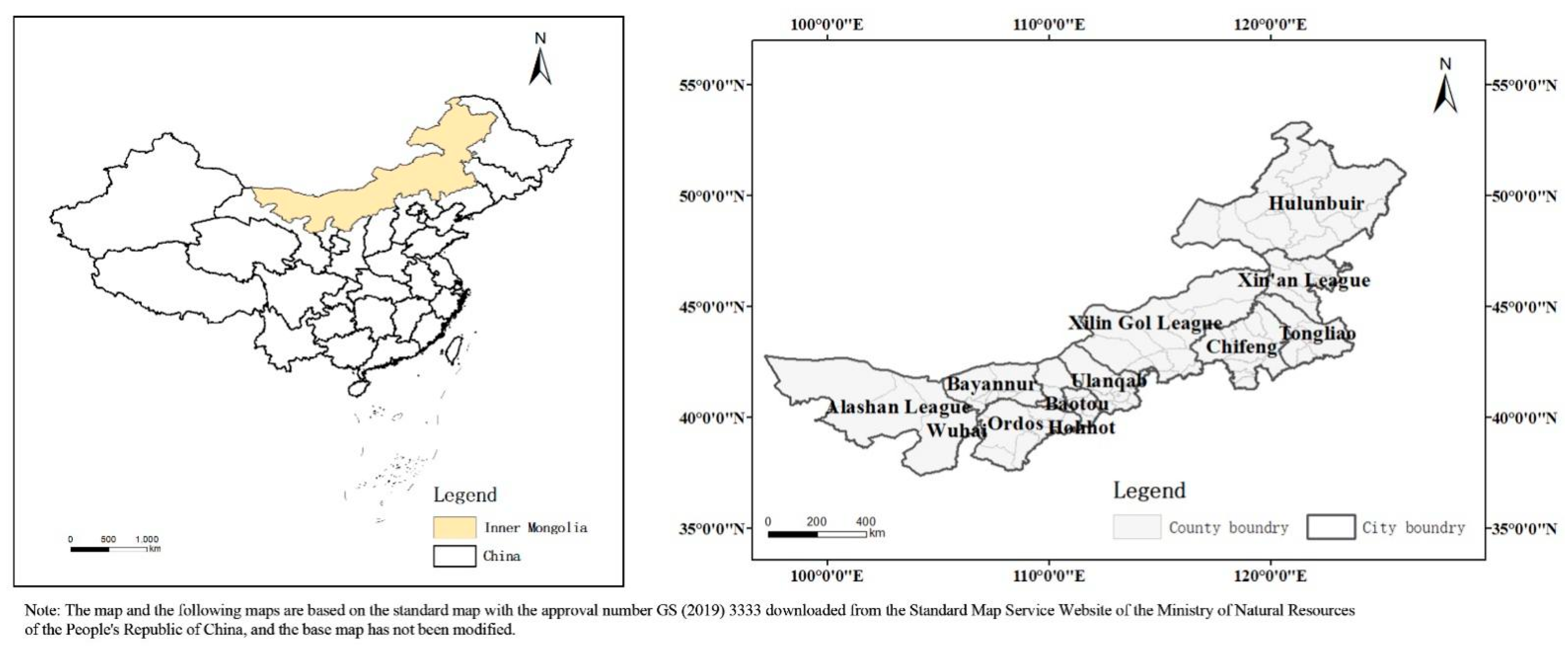
3.1. Selection of the Study Sample

Located on the northern border of China, spanning northeast, north, and northwest China, Inner Mongolia Autonomous Region is the provincial administrative unit with the largest longitude span and the second largest latitude span in China, and is one of the less developed regions in China. Inner Mongolia is connected to eight provinces in China and outreach to Russia and Mongolia, and is a strategic province of “One Belt, One Road” and an important economic zone along the border of China. Its unique geographical location makes Inner Mongolia’s transportation and township development important in the overall development of the country. The narrow and irregular contour structure of the administrative region, the diverse natural environmental factors and the development factors of historical zoning adjustments highlight the fragmented and uneven development characteristics of Inner Mongolia’s own urban linkages, further highlighting the important driving role of transportation facilities in the development of Inner Mongolia’s urban linkages. At present, Inner Mongolia has formed a situation with full coverage of railroad, highway and air transportation modes in 12 leagues and cities. The study of town relations at the level of transportation facilities can, on the one hand, reflect the peculiarities of the development of spatial town links in Inner Mongolia and provide useful references for the construction of new urbanization in Inner Mongolia, and on the other hand, optimize the regional transportation pattern, promote the rational allocation of resource factors and coordinated regional development, and serve as a model for implementing sustainable development strategies for towns and cities.
Inner Mongolia has 9 prefecture-level cities and 3 leagues in the region. There are 103 county-level administrative units in the region, which are 23 municipal districts, 11 county-level cities, 17 counties, 49 banners, and 3 autonomous banners. Because of the closer socioeconomic ties within the municipal districts, the municipal districts of Hohhot, Baotou, Ordos, Wuhai, and Chifeng are combined in this paper as the overall study unit [45]. The Zhalai’er district, which is under the escrow of Manzhouli city, is also included in the overall research unit of Manzhouli city. In this regard, the number of research units in this paper is 89 (Figure 1).

3.2. Data Source

In this paper, using the year 2021 as the time cross-section, authors obtain the data on the passenger frequency of road, railway and air flights between the towns by consulting 12306, coach schedules and WeChat public account of each airline airport, and use the passenger frequency data to characterize the traffic flow between cities in Inner Mongolia. Among them, one day of frequency data is selected as representative for road and rail data; air data is consulted for a week of peak tourist season and the data for the day with the highest number of flights is taken as representative; the study data is collected without considering the need for transit or conversion of transportation modes between two towns [46]. For the shutting down affected by the epidemic, the data refers to the operation data of previous years.

3.3. Methodology

Based on the data of traffic passenger frequency, undirected weighted matrices of different traffic connections between cities and towns are established to obtain the traffic flow network in Inner Mongolia. Network analysis takes the connections between nodes as the unit of analysis and can characterize the complex and complicated connection properties between nodes. Complex network analysis provides quantitative metric measures for traffic flow networks at different scales [47], and the metrics involve centrality, density, and group division.

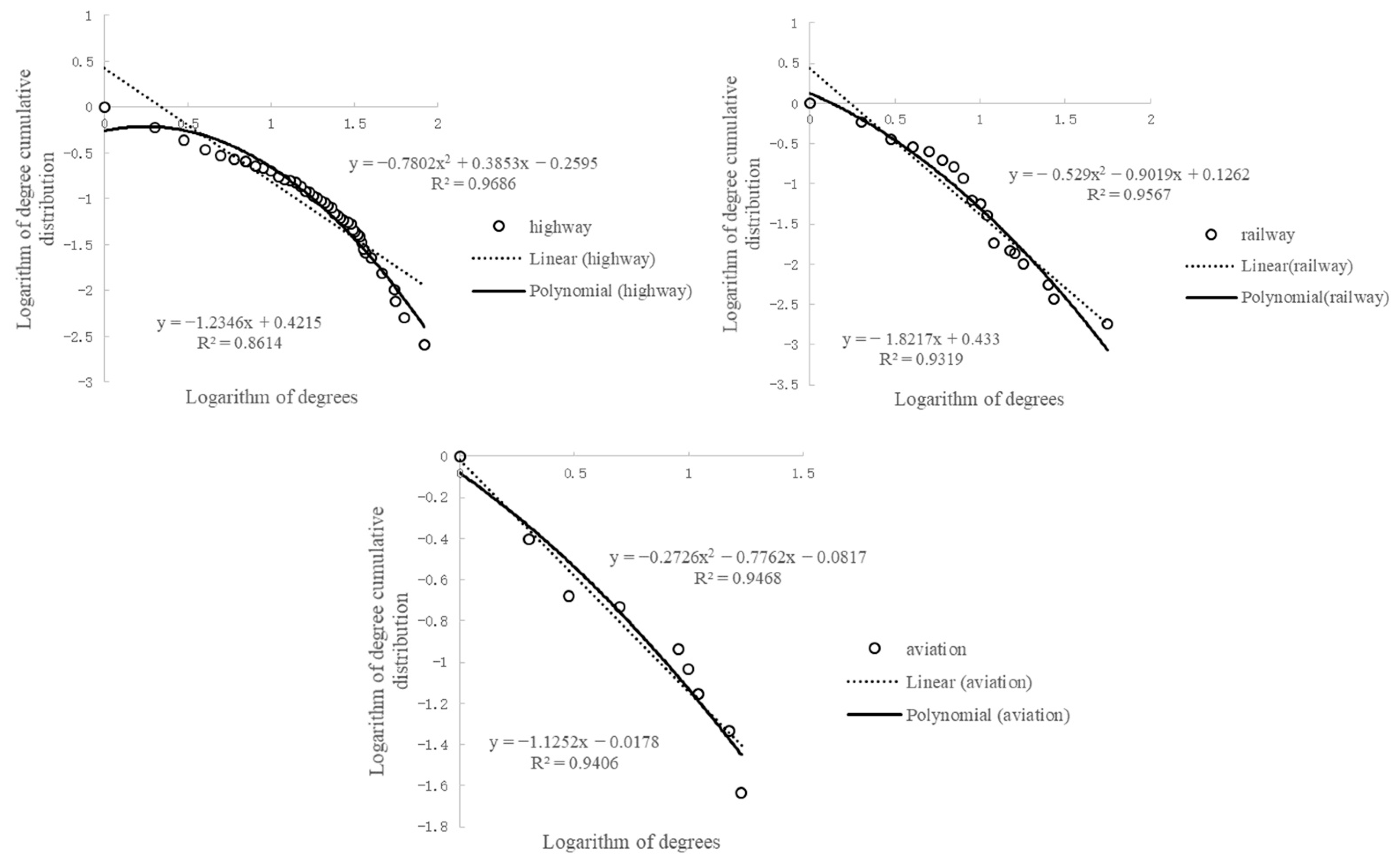
3.3.1. Degree and Cumulative Degree Distribution

The degree is the number of edges connected by a node and is mainly used to portray the position of a town transportation node in the network, both in terms of the number of trips from that node to other nodes and the number of trips from other nodes to that node [48]. The cumulative degree distribution is a reflection of the distribution pattern of the nodes in the network and is the cumulative probability case of the degree distribution of each node [17]. The calculation formula is as follows:
C D = j = 1 n X i j + i = 1 n X i j 2 n 2
P ( k ) = k = k p ( k ) ,     p ( k ) k - γ
where C D is the degree, X i j and X i j denote the direct connection of node i to node j , and node j to node i , respectively, n is the number of nodes, and P ( k ) is the cumulative degree distribution function, which conforms to a power law distribution with γ between 2 and 3, and is therefore a scale-free network [38], such a power-law distribution can be approximated as a straight line in the logarithmic coordinate system after taking the logarithm on both sides. p ( k ) is the node degree distribution, which is the ratio of the number of nodes in the network with degree value k to the total number of nodes in the network.

3.3.2. Small-World Effect

The small-world effect, also known as six-degree space theory, is an important indicator reflecting the efficiency of traffic factor flow. If a traffic flow network has a small average path length L and a high average clustering coefficient C, it means that the network has a small-world effect, which is judged by the following criteria:
L ~ L rand
C > > C rand
where L rand and C rand are the average path length and the average clustering coefficient of a random network of the same size (with the same number of nodes and edges as the network under study), which are equal order quantities of ln n / ln K and K / n (n is the number of nodes and K is the average degree of the network, i.e., the number of edges divided by the number of nodes), respectively, and are often equine quantified in the calculation, and this treatment does not affect the judgment of the results [49].

3.3.3. Identification of Town Clusters

Transportation links between town nodes may be close or sparse, with closely linked town nodes combining to form town clusters. The community discovery algorithm is the clustering algorithm that identifies clusters of towns. In this paper, we use the Fast Unfolding algorithm proposed by Blondel et al. [50], which is a modularity optimization algorithm that considers the connected edge weights, i.e., traffic shifts.
  Q = [ i n + 2 d i , i n 2 n ( a l l + d i 2 n ) 2 ] [ i n   2 n ( a l l   2 n ) 2 ( d i 2 n ) 2 ]
where Q is the modularity value ranging from 0 to 1. A larger Q value indicates a significant community structure division. i n   is the weight of edges inside the town cluster, a l l   is the weight of edges connected to the inside of the town cluster, d i is the weight of edges connecting node i , d i , i n is the weight of edges connecting node i to the inside of the town cluster, and n is the sum of the weights of all connected edges in the network.

4. Results

4.1. Traffic Flow Network Structure Characteristics

The traffic flow network structure is the mapping of urban traffic nodes, traffic connections between nodes and the structural relationship formed by their interweaving in regional space. This subsection makes an in-depth study of the traffic network structure in Inner Mongolia from the three aspects of “point (town node)–line (node connection)–network (space network)”.

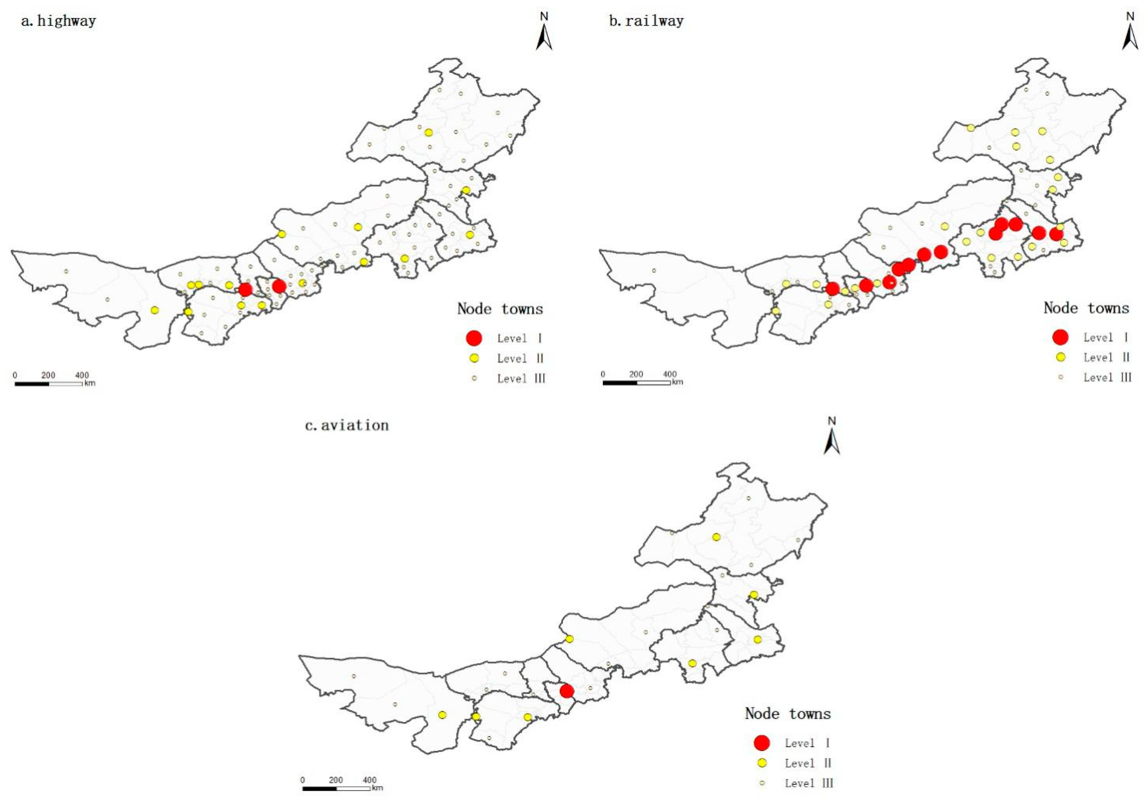
4.1.1. Node Characteristics of Traffic Flow Network

(a)
Node spatial hierarchy differentiation
Based on the traffic flow data in 2021, there are 89 road node towns, 60 railroad node towns, and 25 air node towns in Inner Mongolia, covering 100%, 67.42%, and 28.09% of the county-level administrative units in Inner Mongolia, respectively. Here, the hierarchical visualization of node degree is used to specifically analyze the linkage ability and hierarchical structure of town nodes in different traffic flow networks (Figure 2).
The traffic nodes of cities and towns have significant differences in connection levels, and the spatial level divergence is obvious. Only Hohhot has a level I linkage status in the traffic flow network, and the linkage levels of the rest of the cities and towns vary significantly at the spatial level (Figure 2). In terms of the linkage level of each town, (1) Level I towns. The level I towns of the highway network are Hohhot and Baotou, two prefecture-level cities with prominent regional economic strength. The rail network has a high number of this type, mainly 12 towns along the railway lines Beijing-Baotou line and Jining-Tongliao line, including Hohhot, Ulanqab, Baotou, and Tongliao. The center of the air network is only Hohhot. (2) Level II towns. There are 15 level II towns in the highway network, including 11 prefecture-level cities and border port cities. There are 22 towns of this type in the railway network, most of which are located in the areas near and extended by the Beijing-Baotou line and the Jining-Tongliao line, and along the Harbin-Manzhouli line. The air network has 8 sub-centers, and the 8 sub-centers are the important cities of the four major airport clusters in the northeast, southeast, southwest and west of Inner Mongolia. (3) Level III towns. The number of level III towns in the highway, railway and aviation networks accounts for 80.9%, 43.33%, and 64% of the total number of towns in various transportation networks, respectively. Level III towns with different traffic flow networks basically show a “fragmented” distribution pattern.
  • (b) Node degree function distribution
The double logarithmic curves of the distribution of the node degree and cumulative degree of each traffic network town are fitted for analysis (Figure 3). In the fitting formula, although the fitting effect of the polynomial formula is better than that of the straight-line formula, the fitting degree of the straight-line formula of each transportation network is at an acceptable level, indicating that each transportation network has the tendency to be scale-free network. The connection of most nodes in the Inner Mongolia transportation network needs to rely on the central connection of a few nodes, and the stability of the network connection is general.
Combined with town size indicators (derived by multiplying GDP and population size), the correlation coefficients of the town size indicators are 0.802 for highway town node linkage level, 0.438 for rail town node linkage level, and 0.585 for air town node linkage level. The linkage capacity of road town node is close to the town scale, while the rail and air town node linkage capacity is somewhat different from the town scale. There is a partial discrepancy between the town node characteristics characterized by city scale attributes and the status of town nodes in the traffic flow network, indicating that the node linkage capacity of some transportation hub towns does not match the town scale, and the support of transportation linkage to the development of these town scales is insufficient, and the regional driving force of transportation still needs to be strengthened.

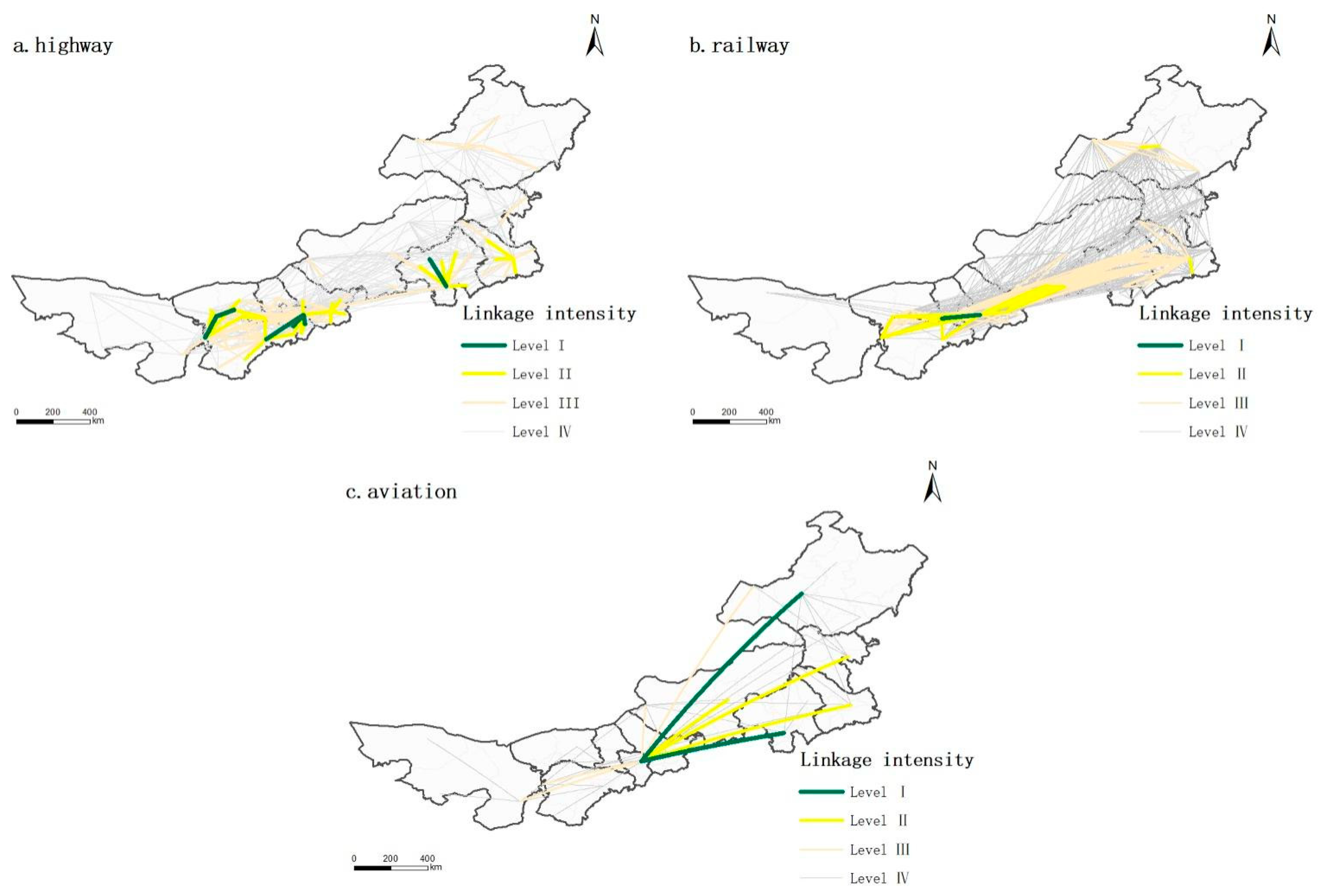
4.1.2. Town Connections Characteristics of Traffic Flow Network

(a)
Spatial differences of town connections
According to the traffic flow data of different traffic modes between the towns, the linkage matrices of highway (89 × 89), railway (60 × 60), and air (25 × 25) are established, respectively, and the linkages of different traffic modes between the towns are classified into four classes with the help of natural breakpoint method (Figure 4). Specifically, it can be seen that:
The highway linkages at I level concentrate 13.8% of the highway passenger flow, manifested as the town linkages between the allied cities of Hohhot-Erdos and Wuhai-Bayannur and the linkages between the towns within the municipalities of Hohhot, Bayannur, and Chifeng. The former is the regional cooperation relationship of close ties between neighboring allied cities, and the latter is the factor flow relationship between prefecture-level cities within allied cities and neighboring towns. The second level concentrates 32.1%, which is the expansion and refinement on the basis of the first level. Hohhot-Erdos and Wuhai-Bayannur municipalities are linked by the intermediate linkage of Baotou, forming a belt-like linkage structure with Ulanqab, which is adjacent to Hohhot. On the other hand, some prefecture-level cities have been formed as the core of the linkage structure, such as the gradually strengthened central position of Chifeng and the intra-municipal linkage of Tongliao as the center and connecting the surrounding towns. Level III concentrates 29.4% of the highway passenger flow. The linkages at level III basically cover 12 league cities, and the town linkages involved and influenced by the belt-like structure of Hohhot–Baotou–Erdos–Ulanqab–Bayannur–Wuhai are getting closer and closer, and the town linkages at local scale show a belt-like clustering pattern. In addition, besides the links between prefecture-level cities and neighboring towns, new features of links of border cities have emerged. The connections at the fourth level concentrates 24.7% of the highway passenger flow. The ties centering on Hohhot and radiating the surrounding towns are more prominent, and the remaining prefecture-level cities still have radiating ties with the surrounding towns.
The railway linkages at level I account for 3.1% of rail passenger traffic flow and concentrates on the town linkages between Hohhot-Baotou-Ulanqab city, which is combined with the Hohhot-Erdos city linkage in the preceding highway network at level I, and together constitute the regional development structure of Hohhot–Baotou–Erdos–Ulanqab integration. Level II accounts for 21.1%. The railroad network in level II has a similar structure compared with the highway network in level II, but the railroad network adds the linkage with Xilin Gol league to the linked skeleton. Tier III takes up 43.4% of rail passenger traffic flow. The ribbon connection of Hohhot–Baotou–Erdos–Ulanqab–Bayannur–Wuhai connects to Xi-Chi-Tong, which constitutes the development axis of Hohhot–Baotou–Yinchuan–Jining–TongLiao line. Among the remaining league connections, Hulunbuir City has formed a small-scale town connection within the city based on the Harbin-Manzhouli Line, while the towns of Alashan League are still independent and only Horqin Right Wing Middle Banner of Xing’an League has established town connections with the neighboring Tongliao City. Tier IV concentrates 32.4% of the railway passenger flow. The development axis of Hohhot–Baotou–Yinchuan–Jining–TongLiao line is further strengthened, and most of the towns outside the axis are not linked in series with the Hohhot–Baotou–Yinchuan–Jining–TongLiao line but show direct connections with the towns along the Hohhot–Baotou–Yinchuan–Jining–TongLiao line. The reason for this is that the main railroad line in Hulunbuir in the eastern part of Mongolia bypasses the northeastern provinces to reach Tongliao to connect with towns in other parts of Inner Mongolia. In contrast, only individual town in Alashan League, a marginal region in western Mongolia, are connected to the Hohhot–Baotou–Yinchuan–Jining–TongLiao line due to natural environmental factors.
The first level of airline connections occupies 26.2% of air passenger traffic flow and is the regional connection between Hohhot and Chifeng, Hailar of Hulunbuir. The second level takes up 24.6% and is the close connection between Hohhot and Ulanhot, Tongliao, Xilinhot in the eastern part of Mongolia. Both level I and level II linkages are characterized by intercity connections between Hohhot and the cities and towns in the eastern part of Mongolia. The third level takes up 14.8% of air passenger traffic flow. Hohhot establishes links with the marginal towns in Inner Mongolia, and links with the border cities of Erlianhot and Manzhouli in Inner Mongolia and Wuhai in the neighboring northwest region are evident. In Tier IV, it occupies 34.4%. Chifeng, Hulunbuir, Ordos and Alxa Left Banner, the important cities of the four major airport clusters in the northeast, southeast, southwest, and west of Inner Mongolia, have shown their connection status. The structure of “two fans concentric” has taken shape.
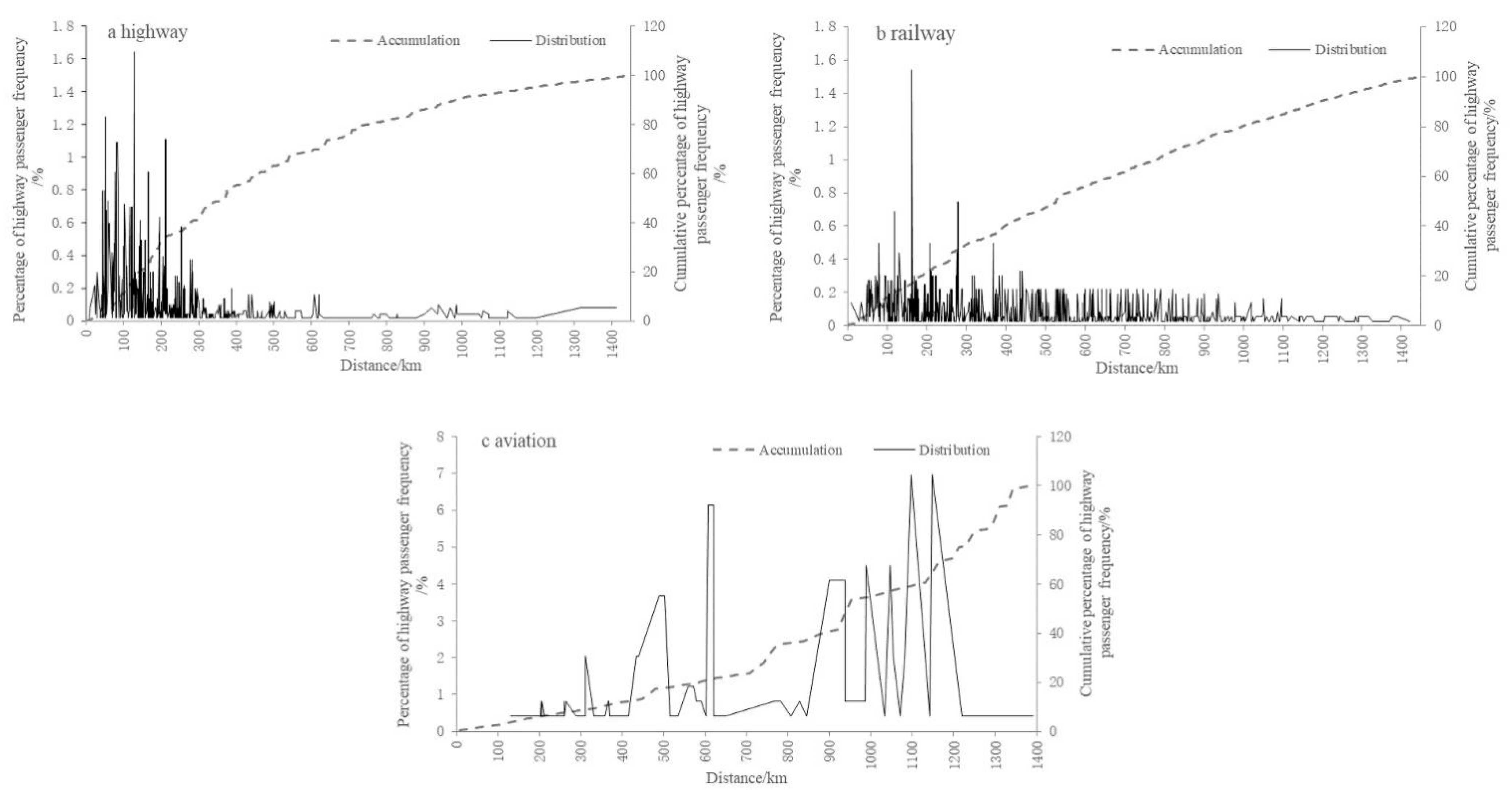
  • (b) Distance distribution of town connections
The hierarchical urban connections under road, railway and air transport modes reflect the obvious spatial interaction and superposition of the hierarchical connections and geographic distances of each town. Affected by the attenuation of spatial distance, urban connections under different transportation modes have different contact ranges. In this regard, the extent of this differential connection is analyzed with the aid of connection strength-distance decay (Figure 5).
Different traffic flow networks serve urban connections with different distances. From the point of view of the distribution rate of transport connection, the connection between road and railway has strong distance sensitivity. The frequency of road and railway increases rapidly within the range of 130 km and 160 km, respectively, and then shows a fluctuating downward trend with the increase of distance. Due to the characteristics of long-distance transportation, the law of distance attenuation in aviation is relatively insignificant. In terms of cumulative shifts, 90% of highway flow is concentrated in the range of 300 km, railway flow is concentrated from 0 to 800 km, and air flow is concentrated from 0 to 1100 km. The highway flow is suitable for short-distance connections within the prefecture-and-city-level and adjacent towns, the railway flow is suitable for medium and long-distance connections within prefecture-and-city-level and adjacent provinces and regions, and the air flow is suitable for long-distance connections inside and outside the province. The complementary advantages and coordinated development of road, railway, and air traffic flow can continuously expand the scope of urban spatial connection and establish internal and external connections between cities and towns in Inner Mongolia.

4.1.3. Overall Structural Characteristics of Traffic Flow Network

(a)
The tightness of the network connection
The cities and towns in Inner Mongolia can establish connections between regions through the combined action of traffic flow and the intermediary action of urban nodes. Only 2.324, 1.838, and 2.34 towns are required to establish urban connections between every two towns on the road, railway, and air network. The average route length of railways is the shortest, and most towns only need to pass through one town to reach their destination. The clustering coefficient of the railway network is 0.759, which is larger than that of the road and aviation. The railway network is a typical small-world network, and the road and aviation network tend to be small-world networks. Compared with the railway network, the average path length of the highway and aviation network is longer and the clustering coefficient is smaller. Since the flow data of highway traffic comes from the frequency of coaches and the aviation network is affected by the actual passenger flow in the region, the local connections of two networks are relatively sparse. The connectivity of towns and cities is relatively weak, and the network connection paths are incomplete.
  • (b) Town cluster structure
Here, the Fast Unfolding algorithm is used to identify clusters for their internal spatial structure. As the road, railroad and air networks are influenced by the distance of transportation modes, the effect of blocking gradually decreases and the structure of grouping changes from clear to blurred (Figure 6).
The highway network with obvious territorial and near-domain characteristics has a clearer grouping at the local scale, with a modularity value of 0.535. A total of six groups are divided, which are divided into four cross-city cooperation types and two adjacent banner-county combination types. The cross-city cooperation type is characterized by frequent flow of factors between the leagues and cities, and the cross-regional cooperation has achieved remarkable results, such as the town cluster of Hohhot, Baotou, Erdos, and a small part of banners and counties in Ulanqab (Cluster 1), town cluster of Hulunbuir and Ulanhot, Arshaan, and Jalaid Banner of Xin’an League (Cluster 2), town cluster of Chifeng and most of banners and counties in Xilin Gol league (Cluster 5), town clusters of Bayannur, Wuhai, Alashan League, and Ertok Banner of Erdos (Cluster 6). The combination type of adjacent banners and counties is represented by the cooperation between the bordering banners and the neighboring cross banners. On the one hand, the banners and counties at the border of cities are relatively limited by the radiation influence of the central area of the city where they are located. On the other hand, due to the role of adjustment of historic zoning and socio-cultural aspects, leapfrogging occurs to establish links with the banners and counties in neighboring cities. For example, the town clusters of Tongliao City, Horqin Right Wing Front and Middle Banner of Xing’an League (Cluster 3), and the town clusters of Xilin Gol League’s Sunit Left Banner, Sunit Right Banner, Bordered Yellow Banner, Erlianhot City and some banners and counties in Ulanqab City (Cluster 4).
The railway network is divided into three groups with a modularity value of 0.278. Cluster 1 mainly focuses on towns along the Beijing-Baotou line and Baotou-Lanzhou in Inner Mongolia section, the Xilinhot–Erlianhot line, the Jining–Erlianhot line, the Baotou-Xi’an line in Inner Mongolia section; Cluster 2 focuses on towns along the Harbin–Manzhouli line; and Cluster 3 mainly focuses on towns along the Jining–Tongliao line and the Baicheng–Arshaan line.
The aviation network is divided into two groups with a modularity value of 0.109. The cluster structure of the air network is not obvious, and the clusters are “fragmented”. Compared with the road and railroad networks, the less geospatially restricted air network combines the eastern part of Inner Mongolia with Hohhot and Wuhai to form a cluster (Cluster 1), which deepens the connection between the midwestern region and the eastern region. Baotou and Erdos link up with Bayannur and Alashan League to form another separate cluster (Cluster 2).

4.2. Spatial Development Patterns of Town Association

The interconnection of transportation infrastructure has formed a diverse transportation network in Inner Mongolia, which can further reflect the particularity of the development of spatial connections in Inner Mongolia. Based on the traffic network analysis results of urban nodes, urban connections and overall structure, this subsection summarizes and refines the urban spatial development mode.

4.2.1. Single Core-Multipoint Mode

The highway connection is mainly based on the regional central city, Hohhot, and some important node cities, such as Baotou, Ordos, Ulanqab, Chifeng, Tongliao, etc. From the perspective of the division of urban clusters, cluster1 with Hohhot, Baotou, and Ordos as the main body has the highest connection strength value. The Hohhot–Baotou–Erdos city group is playing a regional driving role and has attracted some towns in Ulanqab to join the group, and the construction of Hohhot–Baotou–Erdos–Ulanqab integration is gradually advancing. The area centered on the central city of Wuhai, linking the surrounding towns has the common demand for faster development, and under the cross influence of urban cluster along the Yellow River in Ningxia and Hohhot–Baotou–Erdos urban cluster, the “grouping together for warmth” approach is effective. Other urban groups are located in the eastern part of Inner Mongolia. Because they are more likely to be influenced by the neighboring provinces of Heilongjiang, Jilin, and Liaoning, the links between the groups are relatively loose, and the integration of the Xilin Gol–Chifeng–Tongliao town belt and the Hulunbuir–Xing’an League town area is weak. The town linkage pattern of road network is single core-multipoint decentralized type. Single-core refers to the integration trend of urban cluster, with Hohhot regional central city as the core and Baotou and Erdos cities as the neighboring hinterland cities, and multi-point refers to each node city such as Chifeng, Tongliao and Wuhai. The overall performance is the integration scope of the single core and the linkage with each node city, and the linkage of each node city’s territorial and proximity characteristics.

4.2.2. Axis (Channel) Mode

The railway connection is extended and expanded with the Hohhot–Baotou–Yinchuan–Jining–TongLiao line as the development axis. The Hohhot–Baotou–Yinchuan–Jining–TongLiao line shows the ability to gather and radiate resource elements. The cluster identification of the railway connection also highlights the external connection effect of the Harbin–Manzhouli line. The railway network urban development mode is the axis (channel) type, which highlights the channel economic advantages of Inner Mongolia. Inner Mongolia is gradually playing the role of the link and bridge to communicate with North China, Northeast China, Northwest China and Belt and Road countries.

4.2.3. Hub-Spoke Mode

The aviation network fully highlights the directional characteristics of regional axis cities. The aviation network with the characteristics of “hyperspace” transportation has a hub-and-spoke mode of urban connection in Inner Mongolia. The overall performance is a hub-and-spoke service mode that takes Hohhot as a single axis, connects cities outside the province, and radiates within the province. The hub is the single axis that Hohhot undertakes the branch line transfer in the area and the point-to-point connection outside the area. Spoke is the branch towns in Inner Mongolia. Due to the long distance between cities and counties, the branch towns integrate the characteristics of town strings. The further optimization of the hub-and-spoke model can promote the formation of aviation network in Inner Mongolia to form a spatial pattern of four areas in the northeast, southeast, southwest, and west, and “two fans concentric”.

5. Discussion

Considering from the perspective of sustainable development, building a comprehensive transportation network that meets the needs of social and economic development is an important support for sustainable development, especially in underdeveloped areas. Previous studies have focused on the research on transport and urban linkages in more developed areas, which are characterized by multi-center and multi-level network structures [28,33]. However, due to the influence of natural resources, environment, geographical distance and development conditions, transportation linkages and town development in Inner Mongolia have prominent marginal and regional characteristics [45,51]. The town linkage pattern of Inner Mongolia under traffic flow network shows an obvious core-edge pattern, with relatively large transportation linkage costs and high energy consumption, and the insufficient support of the transportation system for town scale development. The research results in the more developed areas are difficult to be directly applied to the topological characteristics of the regional transportation network in Inner Mongolia and the guiding significance for the underdeveloped areas is weak. In this study, based on various traffic flow data in Inner Mongolia, authors conduct an in-depth exploration and analysis of the topological characteristics of the traffic flow network and the urban association mode, to a certain extent, to make up for the existing research on the lack of traffic flow data in underdeveloped areas to describe the regional association structure [52].
Recognizing the structural characteristics and development patterns of urban traffic flow has important practical significance for the subsequent optimization of regional layout, rational utilization of resources and environment, and guidance for the coordinated development of urban structures in underdeveloped areas. The core cities in Inner Mongolia have relatively limited radiation influence, the node cities are underdeveloped, the extension and expansion of the axis is weak, the towns are not compactly connected, the social connections of counties and small towns are relatively weak, and the network structure has not yet been formed.
Based on the results of this study, we propose the following strategies: (1) Adjust the planning of regional transportation network with sustainable development as the cornerstone, give full play to the comparative advantages and combined efficiency of different modes of transportation, strengthen the construction of major corridors for opening up to the outside world, and form an integrated transportation system that connects international, national and regional. (2) Always maintain the intensive use of urban resources and beautiful and livable environment in the construction of road networks, adhere to the principles of greening the economy and low-carbon social construction, and assist in building modern towns with good ecological environment. (3) Play the leading role of regional central city and urban agglomerations in the coordinated development of the region, improve their comprehensive carrying capacity and optimal allocation of resources, release the effect of polarization and diffusion, and better stimulate the vitality of towns of different scales. (4) Actively cultivate regional central cities, central towns and transportation hub towns, gradually cultivate them to form gradient growth poles, enhance the correlation of transportation nodes, and maximize transportation network connections. (5) Take the important development axis as the main frame and promote the nature of axis from transportation axis to industry axis. Close the network connection between the towns on the axis and cities and towns within the influence area of the axis and promote the formation of main axis to extend the development of more cities and counties [53]. (6) Pay attention to the cross-regional links of cities and counties on the edge of the region and border towns, strengthen the cross-regional industrial division of labor and eco-tourism cooperation, extend the scope of regional links, and establish a suitable regional practical open mode and path, build a regional diversified open cooperation platform, in order to promote the deep development of regional ties.
This paper takes Inner Mongolia as a sample to study the traffic flow network structure in less developed regions. Although Inner Mongolia is representative in China, other less developed regions possess other characteristics, so the situation may be different in other less developed regions. In addition, there may be an impact of the new crown pneumonia epidemic with the 2021 passenger frequency data of road, railroad, and air in Inner Mongolia Autonomous Region as the sample. The third limitation of this paper is the lack of representativeness of the impact of the sample data on the environment in terms of sustainable development.

6. Conclusions

Traffic flow network is an important way to understand urban relationships and identify spatial structures and patterns. Through the exploration and analysis of the topological characteristics of the traffic flow network in Inner Mongolia and the urban association model, we obtain the following conclusions: First, the regional central city of Hohhot, important node cities of Baotou, Erdos, and Ulanqab, and the development axis of Hohhot–Baotou–Yinchuan–Jining–TongLiao line in Inner Mongolia all exhibit the ability to gather and radiate resource elements. The less developed areas under the traffic flow network show obvious pointing of core cities and important node towns. The connection of most nodes needs to rely on the intermediate connection of a few nodes. Each transportation network has the tendency to be scale-free network, and the stability of network connection is general, while some transportation hubs are not yet able to support the development of regional urbanization. Second, the highway network is affected by the distance factor and the economy of the administrative region, which is manifested as the connection between the central urban area and the surrounding banner counties and the connection between the adjacent banner counties. It has obvious territorial characteristics and spatial dependence characteristics. The railway network is affected by important traffic trunk lines and is extended with the Hohhot–Baotou–Yinchuan–Jining–TongLiao Line as the development axis. The aviation network is less affected by the attenuation of spatial distance, and has a larger spatial influence range, and mainly serves the spatial connection between the core-peripheral cities in the region and the cities outside the region. Third, each traffic flow network has the “small-world effect”, and the influence of key town nodes in traffic flow network is relatively limited due to spatial distance and geographical environment. The connectivity of towns and cities is relatively weak, and the network connection paths are incomplete. The road network is divided into four cross-city cooperation types and two adjacent banner-county combination types. The railroad network is basically divided into three clusters along the main railroad lines in Inner Mongolia. The cluster structure of the air network is “fragmented”. Fourth, the “Single core-multipoint” development pattern of the highway network shows the spatial organization of township connections within Inner Mongolia. The “axis” of the railroad network and the “hub-spoke” of the air network reflect the spatial organization between Inner Mongolia and the external cities. The urban association structure composed of highway, railway, and aviation network basically conforms to the spatial layout requirements in the new urbanization planning of Inner Mongolia, and basically adapts to the spatial development layout of “one-core, multiple-centers, and one belt and multiple axes”.
The highway, railway, and aviation networks reflect regional spatial connections at different scales. The interdependence and complementation of multiple traffic flows constitute the basic framework of urban spatial development in less developed areas. From a long-term perspective, development segregation between different towns is still an important factor hindering the development of urban linkages in less developed areas. In order to achieve sustainable development in underdeveloped areas, we will continue to pay attention to the optimization of traffic space structure in underdeveloped areas, the influence of external space environment and the linkage development between local areas and focus on the research on cross-interactive development between clusters.

Author Contributions

Conceptualization, X.S. and Y.Y. (Yefei Yang); methodology, C.Z. and Y.Y. (Yafei Yang); formal analysis, Y.Y. (Yafei Yang) and W.Z.; writing—original draft preparation, C.Z. and Y.Y. (Yue Yu); project administration and funding acquisition, Y.Y. (Yefei Yang). All authors have read and agreed to the published version of the manuscript.

Funding

This research was funded by National Natural Science Foundation of China, grant number 72102011.

Institutional Review Board Statement

Not applicable.

Informed Consent Statement

Not applicable.

Data Availability Statement

The data presented in this study are available on request from the author.

Conflicts of Interest

The authors declare no conflict of interest.

References

  1. Zhang, J.J.; Qiang, X.X.; Wei, Q.Q. The research of sustainable urban development in foreign countries. Geogr. Res. 1999, 18, 207–213. [Google Scholar]
  2. Wang, C.; Quan, Y.; Li, X.; Yan, Y.; Zhang, J.; Song, W.; Lu, J.; Wu, G. Characterizing and analyzing the sustainability and potential of China’s cities over the past three decades. Ecol. Indic. 2022, 136, 108635. [Google Scholar] [CrossRef]
  3. Chen, Y.; Zhang, D. Evaluation and driving factors of city sustainability in Northeast China: An analysis based on interaction among multiple indicators. Sustain. Cities Soc. 2021, 67, 102721. [Google Scholar] [CrossRef]
  4. Ke, W.; Lu, Y.; Chen, W.; Ding, Y.; Yang, Q. Evolutionary stages and theoretical model of high-speed traffic network spatio-temporal structure: A case study of expressway traffic flow network in Jiangsu province. Acta Geogr. Sin. 2016, 71, 281–292. [Google Scholar]
  5. Lyapin, S.; Rizaeva, Y.; Kadasev, D.; Sysoev, A. Methods to Analyze Traffic Demand Formation in Intelligent Transportation and Logistic Regional Network. Transp. Res. Procedia 2020, 45, 522–529. [Google Scholar] [CrossRef]
  6. Rasoolimanesh, S.M.; Badarulzaman, N.; Jaafar, M. City development strategies (CDS) and sustainable urbanization in developing world. Procedia-Soc. Behav. Sci. 2012, 36, 623–631. [Google Scholar] [CrossRef] [Green Version]
  7. United Nations. Transforming Our World: The 2030 Agenda for Sustainable Development; United Nations: New York, NY, USA, 2014.
  8. Abubakar, I.R.; Aina, Y.A. The prospects and challenges of developing more inclusive, safe, resilient and sustainable cities in Nigeria. Land Use Policy 2019, 87, 104105. [Google Scholar] [CrossRef]
  9. Wang, Y.; Lu, Y.; He, G.; Wang, C.; Yuan, J.; Cao, X. Spatial variability of sustainable development goals in China: A provincial level evaluation. Environ. Dev. 2020, 35, 100483. [Google Scholar] [CrossRef]
  10. Han, Z.; Jiao, S.; Zhang, X.; Xie, F.; Ran, J.; Jin, R.; Xu, S. Seeking sustainable development policies at the municipal level based on the triad of city, economy and environment: Evidence from Hunan province, China. J. Environ. Manag. 2021, 290, 112554. [Google Scholar] [CrossRef]
  11. Xue, B.; Liu, B.; Yang, Q.; Sun, X.; Wang, W.; Li, L. Formalizing an evaluation-prediction based roadmap towards urban sustainability: A case study of Chenzhou, China. Habitat Int. 2021, 112, 102376. [Google Scholar] [CrossRef]
  12. Merino-Saum, A.; Halla, P.; Superti, V.; Boesch, A.; Binder, C.R. Indicators for urban sustainability: Key lessons from a systematic analysis of 67 measurement initiatives. Ecol. Indic. 2020, 119, 106879. [Google Scholar] [CrossRef]
  13. Melkonyan, A.; Gruchmann, T.; Lohmar, F.; Bleischwitz, R. Decision support for sustainable urban mobility: A case study of the Rhine-Ruhr area. Sustain. Cities Soc. 2022, 80, 103806. [Google Scholar] [CrossRef]
  14. Alderson, A.S.; Beckfield, J.; Sprague-Jones, J. Intercity Relations and Globalisation: The Evolution of the Global Urban Hierarchy, 1981–2007. Urban Stud. 2010, 47, 1899–1923. [Google Scholar] [CrossRef]
  15. Hu, X.; Su, Y.; Ren, K.; Song, F.; Xue, R. Measurement and influencing factors of urban traffic ecological resilience in developing countries: A case study of 31 Chinese cities. Reg. Sustain. 2021, 2, 211–223. [Google Scholar] [CrossRef]
  16. Jin, P.; Mangla, S.K.; Song, M. Moving towards a Sustainable and Innovative City: Internal Urban Traffic Accessibility and High-level Innovation Based on Platform Monitoring Data. Int. J. Prod. Econ. 2021, 235, 108086. [Google Scholar] [CrossRef]
  17. Castells, M. Globalisation, Networking, Urbanisation: Reflections on the Spatial Dynamics of the Information Age. Urban Stud. 2010, 47, 2737–2745. [Google Scholar] [CrossRef]
  18. Matsumoto, H.; Domae, K. Assessment of competitive hub status of cities in Europe and Asia from an international air traffic perspective. J. Air Transp. Manag. 2019, 78, 88–95. [Google Scholar] [CrossRef]
  19. Derudder, B.; Witlox, F. Mapping world city networks through airline flows: Context, relevance, and problems. J. Transp. Geogr. 2008, 16, 305–312. [Google Scholar] [CrossRef]
  20. Liu, X.; Derudder, B.; Wu, K. Measuring Polycentric Urban Development in China: An Intercity Transportation Network Perspective. Reg. Stud. 2016, 50, 1302–1315. [Google Scholar] [CrossRef]
  21. Weber, J. The Evolving Interstate Highway System and the Changing Geography of the United States. J. Transp. Geogr. 2012, 25, 70–86. [Google Scholar] [CrossRef]
  22. Feng, X.; Xiu, C.; Bai, L.; Wen, Y. Urban Centrality and Influencing Factors in Jilin Province from the Perspective of Highway Traffic Flow. Econ. Geogr. 2019, 39, 64–72. [Google Scholar]
  23. Tang, E.B.; Zhang, M.Q. Urban Rail Accessibility and Interurban Spatial Effects on the Background of High-Speed rail in Jiangxi Province. Resour. Environ. Yangtze Basin 2018, 27, 2241–2249. [Google Scholar]
  24. Zhao, Y.; Chu, N.; Guo, J.; Jiang, B.; Zhu, L. High-Speed Railway Network Structure and Characteristics in Three Urban Agglomerations in China. Econ. Geogr. 2017, 37, 68–73. [Google Scholar]
  25. Geng, L.I.; Zong, H.M. Study on Multi-centered Degree of Chengdu-Chongqing Urban Agglomerations Based on Railway Transportation. J. Southwest Univ. 2019, 41, 109–116. [Google Scholar]
  26. Zambrano-Martinez, J.L.; Calafate, C.T.; Soler, D.; Cano, J.C.; Manzoni, P. Modeling and characterization of traffic flows in urban environments. Sensors 2018, 18, 2020. [Google Scholar] [CrossRef] [Green Version]
  27. Chrpa, L.; Magazzeni, D.; McCabe, K.; McCluskey, T.L.; Vallati, M. Automated planning for Urban traffic control: Strategic vehicle routing to respect air quality limitations. Intell. Artif. 2016, 10, 113–128. [Google Scholar]
  28. Cheng-Lin, M.U.; Lin, L.U.; Huang, J.F.; Wang, Y.; Deng, H.B. Research on Yangtze River Delta Tourist Traffic Pattern and Linkage Under the High-Speed Rail Network. Econ. Geogr. 2015, 35, 193–202. [Google Scholar]
  29. Yang, X.M.; Ling-Qin, L.I.; Jian-Xin, F.U.; Cao, G.C.; Tang, Z.X.; Ya-Ling, L.I.; Wang, H.W.; Wang, R.Q.; Liu, A.J. Pattern variation of accessibility and economic linkage at county scale in Qinghai Province from 1986 to 2016. Arid. Land Geogr. 2018, 41, 1376–1387. [Google Scholar]
  30. Ke, W.; Chen, W.; Lu, Y.; Yu, Z.; Yang, Q. Extracting Spatial Structures and Evolutionary Characteristics of City Networks in Jiangsu Province Based on the Expressway Traffic Flow. Sci. Geogr. Sin. 2019, 39, 405–414. [Google Scholar]
  31. Mahutga, M.C.; Ma, X.L.; Smith, D.A.; Timberlake, M. Economic Globalisation and the Structure of the World City System: The Case of Airline Passenger Data. Urban Stud. 2010, 47, 1925–1947. [Google Scholar] [CrossRef]
  32. Zhou, Y.; Hu, Z. Looking into the network structure of Chinese urban system from the perspective of air transportation. Geogr. Res. 2002, 21, 276–286. [Google Scholar]
  33. Yang, S.; Zhang, L.C.; Yao, S.M. Spatial flow network structural features of the urban agglomeration in the Yangtze River Delta: A comprehensive analysis based on road transportation, railway passenger transportation, and Baidu indexes. Resour. Environ. Yangtze Basin 2017, 26, 1304–1310. [Google Scholar]
  34. Gao, S.; Wang, Y.L.; Gao, Y.; Liu, Y. Understanding urban traffic-flow characteristics: A rethinking of betweenness centrality. Environ. Plan. B Plan. Des. 2013, 40, 135–153. [Google Scholar] [CrossRef] [Green Version]
  35. Porta, S.; Crucitti, P.; Latora, V. The Network Analysis of Urban Streets: A Dual Approach. Phys. A Stat. Mech. Its Appl. 2006, 369, 853–866. [Google Scholar] [CrossRef] [Green Version]
  36. Watts, D.J.; Strogatz, S.H. Collective dynamics of ’small-world’ networks. Nature 1998, 393, 440–442. [Google Scholar] [CrossRef]
  37. Barabási, A.; Albert, R. Emergence of Scaling in Random Networks. Science 1999, 286, 509–512. [Google Scholar] [CrossRef] [Green Version]
  38. Newman, M. The structure and function of complex networks. SIAM Rev. 2003, 45, 167–256. [Google Scholar] [CrossRef] [Green Version]
  39. Gao, Z.Y.; Zhao, X.M.; Huang, H.J.; Mao, B.H. Research on Problems Related to Complex Networks and Urban Traffic systems. J. Transp. Syst. Eng. Inf. Technol. 2006, 6, 41. [Google Scholar]
  40. Porta, S.; Crucitti, P.; Latora, V. The Network Analysis of Urban Streets: A Primal Approach. Environ. Plan. B Plan. Des. 2006, 33, 705–725. [Google Scholar] [CrossRef] [Green Version]
  41. Baibai, F.U.; Gao, Z.; Liu, F.; Kong, X. Express passenger transport system as a scale-free network. Mod. Phys. Lett. B 2006, 20, 1755–1761. [Google Scholar]
  42. Jiang, B. A topological pattern of urban street networks: Universality and peculiarity. Phys. A Stat. Mech. Its Appl. 2007, 384, 647–655. [Google Scholar] [CrossRef] [Green Version]
  43. Xueguang, M.A.; Dou, P. Characteristics of Polycentricity Spatial Structure of Shandong Coastal City-region Based on Passenger Traffic Flow. Mod. Urban Res. 2017, 10, 101–109. [Google Scholar]
  44. Xing, C.-M.; Liu, F.-A. Research on the deterministic complex network model based on the Sierpinski network. Acta Phys. Sin. 2010, 59, 1608–1614. [Google Scholar] [CrossRef]
  45. Wang, F.; Gao, X.L. Spatial Pattern Evolvement of the Economy in Inner Mongolia at the County Level. Sci. Geogr. Sin. 2014, 34, 818–824. [Google Scholar]
  46. Wang, J.; Jing, Y. Comparison of spatial structure and organization mode of inter-city networks from the perspective of railway and air passenger flow. Acta Geogr. Sin. 2017, 72, 1508–1519. [Google Scholar]
  47. Xd, A.; Min, X.B.; Nw, A. The industrial impact of the Beijing-Shanghai high-speed rail. Travel Behav. Soc. 2018, 12, 23–29. [Google Scholar]
  48. Qinghua, Z.; Liang, L. Social Network Analysis Method and Its Application in Information Science. Inf. Stud. Theory Appl. 2008, 31, 179–183. [Google Scholar]
  49. Wang, G.M.; Xia-Miao, L.I.; Yang, B.; Zheng-Dong, H.U. The Properties of Traffic Networks in Urban Agglomeration. Comput. Eng. Sci. 2012, 34, 174–182. [Google Scholar]
  50. Blondel, V.D.; Guillaume, J.-L.; Lambiotte, R.; Lefebvre, E. Fast unfolding of communities in large networks. J. Stat. Mech. Theory Exp. 2008, 2008, P10008. [Google Scholar] [CrossRef] [Green Version]
  51. Tang, H.X.; Wang, D. Research on the construction of comprehensive transportation system in southwest frontier minority areas. Guangxi Soc. Sci. 2018, 2018, 92–97. [Google Scholar] [CrossRef]
  52. Chen, W.; Liu, W.; Ke, W.; Wang, N. Understanding spatial structures and organizational patterns of city networks in China: A highway passenger flow perspective. Acta Geogr. 2018, 28, 477–494. [Google Scholar] [CrossRef] [Green Version]
  53. Feng, X.; Xiu, C.; Liu, Z.; Ma, L.; Li, X. Characteristics of Urban Network Hierarchy Evolution Based on the Perspective of Railway Passenger Transport in Northeast China. Sci. Geogr. Sin. 2018, 38, 1430–1438. [Google Scholar]
Figure 1. Location of the study area.
Sustainability 14 08095 g001
Figure 2. Urban level of Inner Mongolia under different traffic flow network.
Sustainability 14 08095 g002
Figure 3. Distribution of node degree in Inner Mongolia under different traffic flow network.
Sustainability 14 08095 g003
Figure 4. Urban connection structure of Inner Mongolia under different traffic flow network.
Sustainability 14 08095 g004
Figure 5. Distance attenuation in Inner Mongolia under different traffic flow network.
Sustainability 14 08095 g005
Figure 6. Town clusters under different traffic flow network.
Sustainability 14 08095 g006
Publisher’s Note: MDPI stays neutral with regard to jurisdictional claims in published maps and institutional affiliations.

