Article

ICT Uses, Constraints, and Challenges in Flash Flood Risk Management: A Case Study in North-Eastern Haor Areas of Bangladesh

1
Department of Soil Science, Bangladesh Agricultural University, Mymensingh 2202, Bangladesh
2
Rural Planning and Sustainable Rural Development Laboratory, Kyoto University, Kyoto 615-8530, Japan
3
Department of Agricultural Extension (DAE), Ministry of Agriculture, Dhaka 1000, Bangladesh
4
Department of City and Metropolitan Planning, The University of Utah Asia Campus, Yeonsu-Gu, Incheon 21985, Korea
5
Institute of Water and Flood Management, Bangladesh University of Engineering and Technology (BUET), Dhaka 1000, Bangladesh
6
Department of Chemistry, Faculty of Science, Taif University, P.O. Box 11099, Taif 21944, Saudi Arabia
7
Department of Biology, College of Science, Taif University, P.O. Box 11099, Taif 21944, Saudi Arabia
*
Authors to whom correspondence should be addressed.
Sustainability 2022, 14(13), 8018; https://doi.org/10.3390/su14138018
Submission received: 22 April 2022 / Revised: 21 June 2022 / Accepted: 28 June 2022 / Published: 30 June 2022
(This article belongs to the Special Issue ICT Adoption for Sustainability)

Abstract

:
This study intends to explore the extent of the use of information and communication technology (ICT) in flash-flood-prone haor (wetland ecosystem) areas of north-eastern Bangladesh. Addressing the situation of severe flash floods in 2017 at the community level, this study aims to examine the constraints and challenges in using ICT for flash flood risk management. An empirical study was conducted in two upazilas (administrative sub-districts) within the Sunamganj, the most affected district. A total of 120 household heads were interviewed using a semi-structured questionnaire. Focused group discussions (FGD) and key informant interviews (KII) were also used. Results reveal that people in these areas do not use computers or Internet. However, the use of mobile phones is common for communication during disasters. Illiteracy, poor quality of life, poor social capital, poor infrastructure, and poor communication with institutions are highlighted as the main constraints and challenges in the effective application of ICT in flash flood management. The results showed that the local community people of the study area receive early warning and hazards preparedness-related information through mobile phones, television, radio, and Facebook. However, the results also highlighted the constraints and challenges in applying ICT in DRR at the community level. By addressing a remote region and a relatively less focused disaster (flash flood), this study contributes to boosting the application of ICT in DRR, especially in remote, disadvantaged communities.

1. Introduction

Information and communications technology (ICT) is emerging worldwide as an integral aspect of human lives. Scholars argue that ICT plays a critical role in all aspects of life, ranging from personal communication between individuals and interaction within and between communities to global trade and commerce, knowledge sharing, and negotiation [1]. In addition, ICT is an accelerator of social and economic progress [2]. In today’s world, ICT is gaining more importance for disaster risk reduction (DRR) [3]. Almost all developed countries extensively use ICT and ICT-based applications to manage natural hazards, as ICT encompasses both traditional media (radio, television) as well as new emerging media (cell broadcasting, the Internet, satellite radio, etc.). All these communication media play a major role in minimizing the risks of a potential or impending disaster. Before disasters strike, ICT is used as a channel for disseminating information about impending danger, thus making it possible to take the necessary precautions to mitigate the impact of these hazards. For example, television is used as the most common and popular platform for early warning to minimize the negative impacts of different natural hazards in Bangladesh. Hence, to achieve effective DRR, it is crucial that the application of ICT is consistent in risk areas [4]. In terms of flooding events, ICT plays an increasing role in different stages of flood risk management, including forecasting and prediction, early warning, mitigation, response, and recovery, as well as rehabilitation [5]. These can be accomplished in flood risk management using different types of ICT, such as remote sensing, geographic information systems, satellite and space technology, wireless sensor networks, mobile technology, and social media.
Due to the emerging and crucial role of ICT, the Bangladesh government has assigned the highest priority to develop ICT and its various applications in all sectors of development and management [4]. The government has placed a high level of emphasis on digital technologies, with the state-sponsored digital initiative ‘Digital Bangladesh’ being used to promote different ambitious ICT projects that aim for a poverty-free and more inclusive society by 2021 [6]. In addition to socio-economic development, the government considered the crucial role of ICT in disaster management and preparedness by mainstreaming disaster preparedness and management in its National ICT Policy 2009 [7]. It is well known internationally that Bangladesh is one of the most disaster-prone countries in the world [8]. Of the different types of disaster, floods and cyclones are the most common hazards faced in Bangladesh. Although flooded rivers have a widespread impact, flash floods are emerging as severe hazardous events in almost all countries [9], especially in the north-eastern areas of Bangladesh. As Bangladesh is a low-lying country, the frequency, intensity, and duration of floods have significantly increased in the last few decades, and it covers 13% of Bangladesh [10]. As flash flood occurs very frequently in Bangladesh, an early forecasting system can significantly mitigate the severity of flash floods [11,12]. Although there are some conventional early warning systems to minimize the negative impact of monsoon floods, there is no flash flood early warning system available in haor areas of Bangladesh.
The wetland region of north-eastern Bangladesh, known as the haor, is highly prone to flash floods. In early 2017, nearly one million households were affected by a flash flood that damaged rice crops valued at USD 450 million [13]. As reported in one study, flash floods cause enormous damage to crop production and place the agricultural sector at significant risk [14]. They also threaten the lives and livelihoods of the people. Local people usually follow and use different approaches to obtain information related to flash floods and associated issues, with this information utilized for preparedness, risk reduction, and recovery. Among these approaches, the extent of ICT uses and its constraints and challenges are not yet known. In different parts of the world, initiatives and research have been undertaken related to the use, benefits, constraints, and challenges associated with ICT use, especially in relation to disaster management [2,15]. In Bangladesh, academic studies have identified the use and challenges of ICT in the education sector as well as the overall challenges [6,16,17].
Sustainability is composed of ecological, economic, social, environmental, and political aspects. Adoption of ICT by the local government can contribute to mitigating flash flood risk in the haor areas of Bangladesh and leads to the development of a sustainable, resilient community [18]. Previous research suggests that quality and management practices of ICT can play a significant positive role in sustainability, including environmental, social, and economic sustainability [19]. Thus, the adoption of ICT in flash flood management will ensure social sustainability by implementing an early warning system; economic sustainability by minimizing economic loss in agriculture, fisheries, and households; and ecological sustainability by an information-based land use system (bottom layer fish sanctuary and upland rice cultivation). Combining all these approaches will finally lead to a sustainable information society and a flash-flood-resilient community [20]. However, no academic research has addressed the uses and challenges of ICT applications, specifically in flash flood management in the haor region. The haor is a unique region of Bangladesh, and flash floods are, to some extent, unique to that region.
Therefore, considering the haor region, flash floods, and ICT, this study attempts to determine the ways in which ICT was used in recent flash flood management at the community level. This study employs a quantitative approach to investigate how to adopt ICT in flash flood risk management and how this adoption improves ecological and social sustainability. The study also identifies the constraints and challenges faced by ICT in successfully implementing flash flood management at various levels in the affected area. With an empirical study in two sub-districts (upazilas), this study explores whether significant differences occurred in ICT use and constraints in these two different areas. The conceptual framework or layout of the present study is presented in Figure 1.

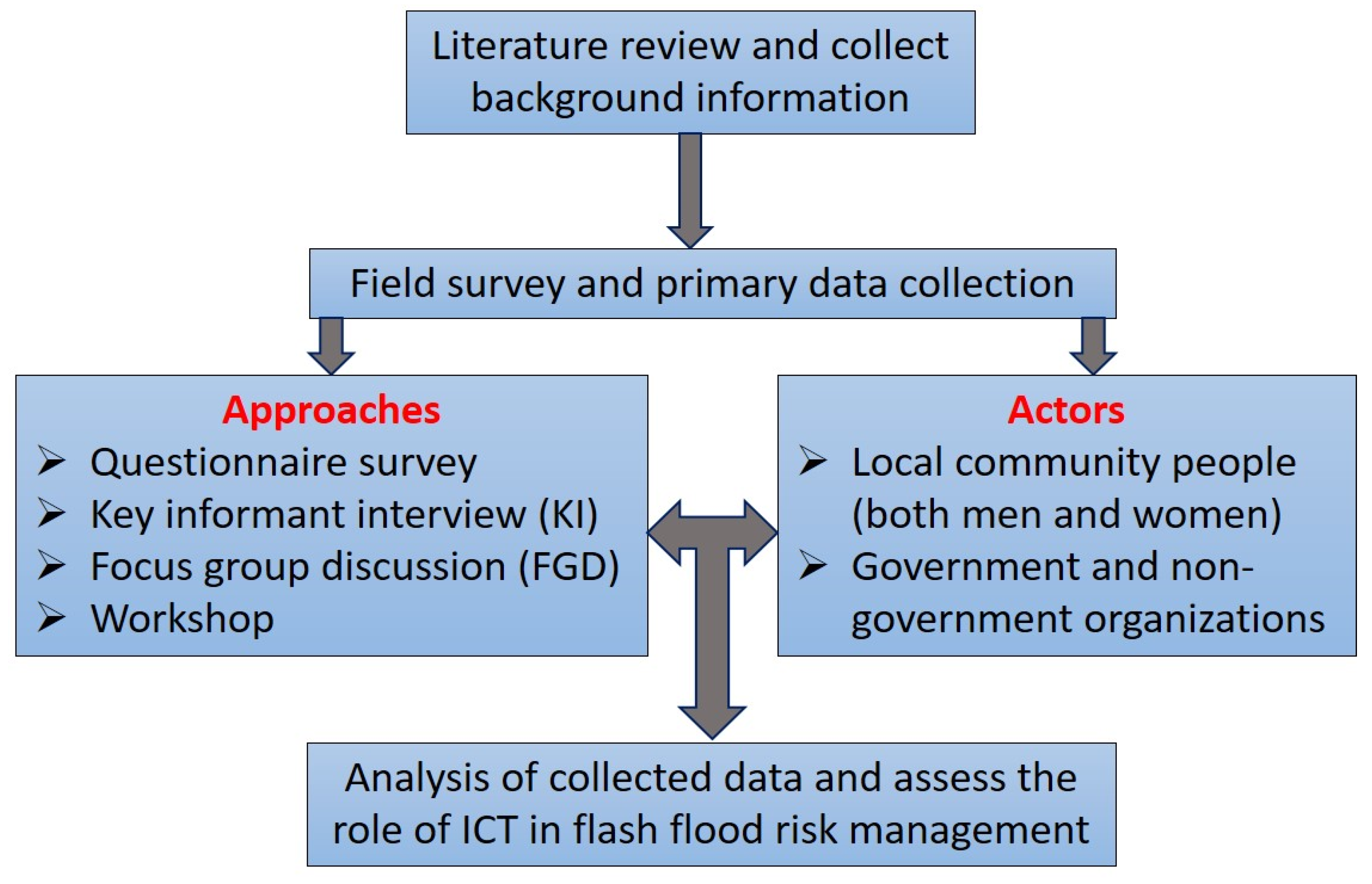
2. Materials and Methods

The north-eastern region of Bangladesh (Sunamganj district: the most flash-flood-affected region) was selected as the study area in the present study. The study was conducted at the community level in two upazilas within the Sunamganj district. The sampling unit was an individual person representing a family. Without following a sound sampling technique due to time and resource limitations, a total of 120 individuals (60 persons from each upazila) were interviewed using a semi-structured questionnaire (Supplementary Materials).
Respondents were randomly selected with attempts made to cover all types of livelihood groups. The questionnaire survey was conducted over about three weeks from 6–26 December 2017 (a few months after the flash flood). The main aspects addressed in the questionnaire were the impact of the flash flood, types of ICT use, constraints in the use of ICT, and expectations for enhancing ICT use for flash flood management. To validate the data, focus group discussions (FGDs) (one in each upazila) and key informant interviews (mainly with an agriculture officer, upazila officials, and local leaders) were conducted (Table 1). Microsoft (MS) Excel and IBM’s SPSS Statistics were used for data processing and analysis. Cross-tabulation, descriptive statistics, and chi-square tests were conducted at the community level to explore any significant differences between the two upazilas in ICT use, constraints, and expectations.

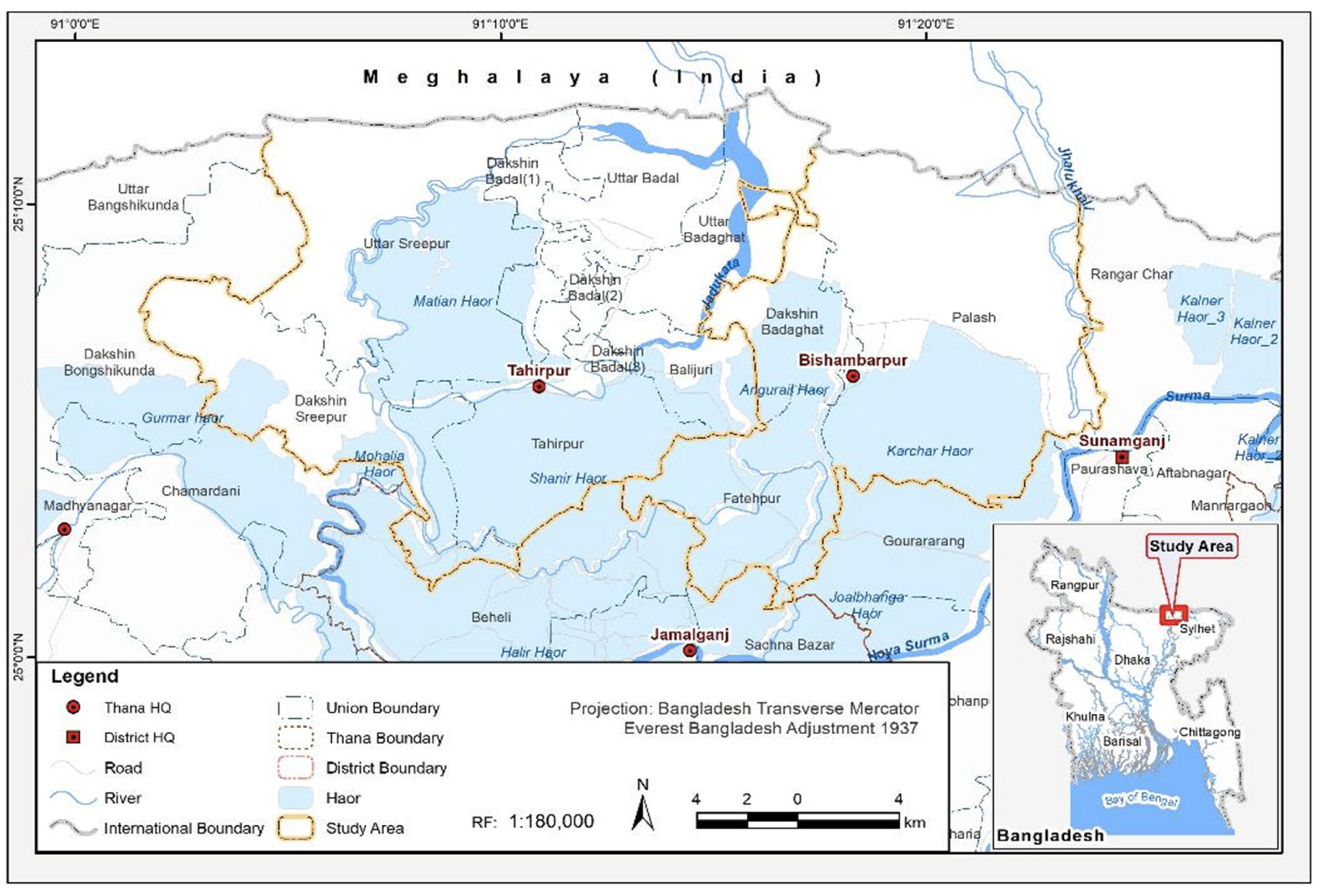
2.1. Study Area and Studied Communities

2.1.1. Study Area

In Bangladesh, the north-eastern haor (wetland) region comprises six districts (Sylhet, Moulauvibazar, Sunamganj, Habiganj, Netrokona, and Kishoreganj.). The Bangla term haor means a wetland ecosystem that is topographically a bowl-shaped shallow area, also known as ‘black swamp’ [21,22]. During the monsoon, due to receiving run-off water from rivers and canals, the haor turns into a vast area of water, and the villages seem like islands. However, after the monsoon, the area gradually becomes vast green land.
The haor region is prone to flash floods: the flash flood in 2017 was devastating. According to the Department of Agricultural Extension (DAE) [23], the Sunamganj district was the most affected among the above-mentioned six districts by the early flash flood in 2017. Therefore, this study selected as its study area two upazilas (sub-districts), Bishwamvarpur and Tahirpur, from the Sunamganj district (Figure 2).
Flash floods occur in this area mainly due to heavy rainfall from the very steep uplands in the Meghalaya Hills [24]. The Meghalaya Hills on the Indian side of the border are among the world regions that receive the maximum annual rainfall (12,000 mm). According to the Center for Environmental and Geographic Information Services (CEGIS) [25], the mean annual rainfall in the Sunamganj district varies between 3600 mm and 7800 mm. Many rivers flowing into Bangladesh have their source in the hills of Meghalaya in that territory. Every monsoon, these rivers overflow riverbanks and embankments, causing flooding and damage to crops and other property.
The study area covers 440.70 km2 and supports a population of 0.26 million. The literacy rate is 31.45%. Agriculture is the largest producing sector of the economy, employing 66.52% of the population. Aside from agriculture, other income-generating activities carried out in this region include fishing, business, services, wage labor, stone collection, etc. [22].

2.1.2. Studied Communities

To vividly depict a community’s ICT utilization, it is necessary to understand the people’s socio-economic characteristics, their location, ICT coverage, and their responses to the flash flood occurring around them. The extent of a community’s risk from hazards depends on the frequency and severity of hazards and their vulnerability to those hazards [26]. Table 2 shows the socio-economic characteristics of the people studied. As shown in the table, most people are aged between 26 and 50, indicating that they are still young when it comes to adopting ICT to minimize flash flood risk. In terms of education, the educational level of most respondents varies from primary to secondary levels.
The main source of livelihood in the study area is agriculture. However, in Tahirpur upazila, services are also an important source of livelihood. In the case of housing, people of Bishwamvarpur upazila live in better houses compared to those in Tahirpur upazila, with the findings denoting that more than half the people in Bishwamvarpur live in a pacca house. It was thought in this study that the socio-economic differences in the two studied communities could influence their use of ICT and the constraints they face in ICT use.

3. Results

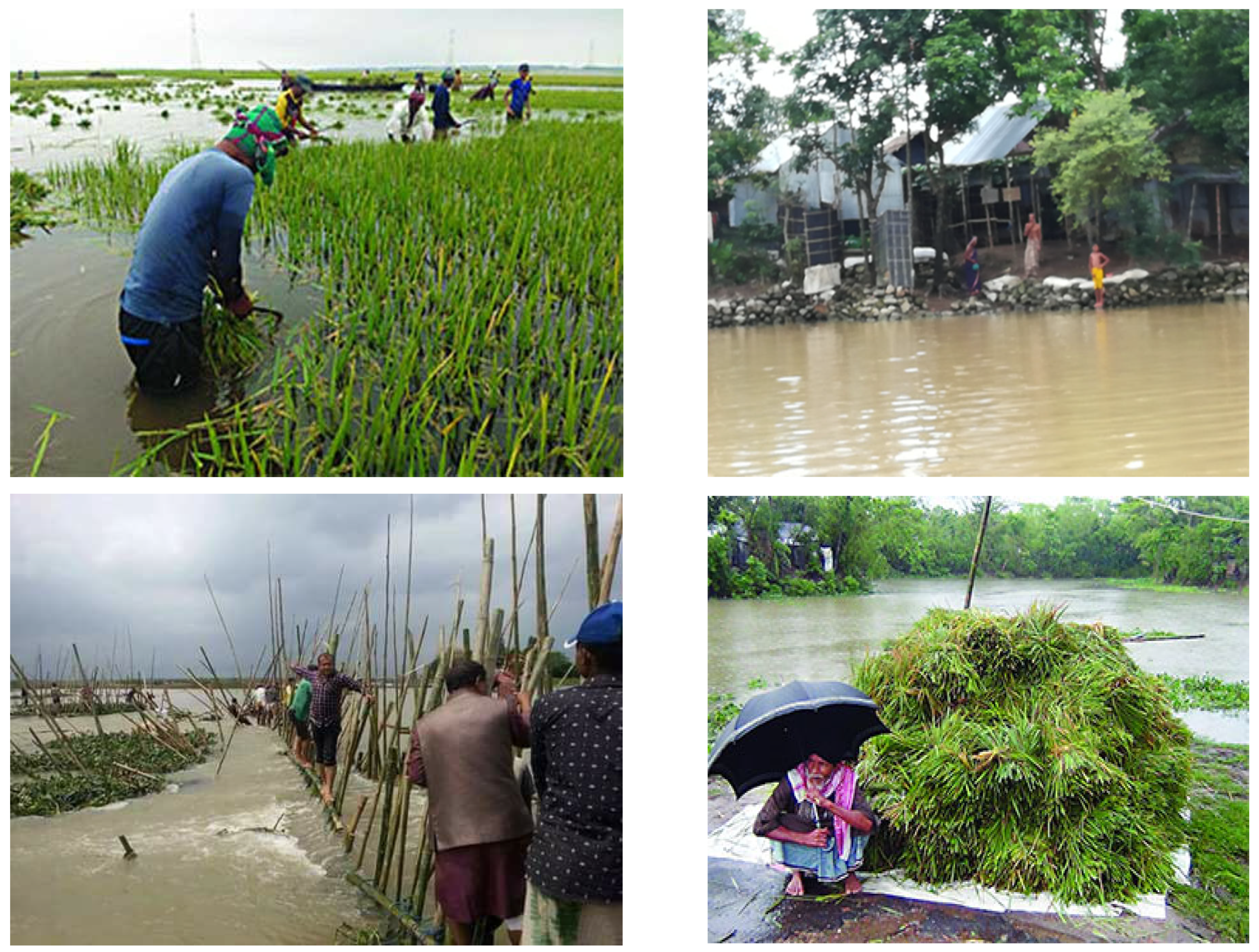
3.1. Impacts of 2017 Flash Flood

Excess rainfall in the upstream hilly areas and subsequent run-off, sedimentation in the rivers, deforestation and hill degradation, improper drainage, unplanned road and water management infrastructure, and the effect of climate variability are believed to be the major triggers of flash floods in this region. Generally, flash floods occur in the haor areas in the early monsoon (from the end of April through the month of May), with farmers not having sufficient time to harvest their standing boro rice crop. The flash flood in 2017 triggered a situation of havoc for the people in the haor areas as the floodwaters came very quickly. The rising water was reported to have overflowed and breached embankments, inundating vast areas of crop lands.
In the Sunamganj district, although flash floods hit almost every year, the boro rice crops of Matian Haor, Tanguar Haor, and Shanir Haor in Tahirpur upazila were drastically affected by the flash flood (Figure 3). As shown in Table 3, most of the respondents in both upazilas highlighted that agriculture was badly affected by the flash flood in 2017. When a flash flood occurs in this area, the boro rice stands during that period in the field. However, when a sudden flash flood occurs accompanied by an onrush of water, this completely damages the boro rice crops. Apart from agriculture, more than 50% of Bishwamvarpur upazila respondents mentioned that safe drinking water and sanitation systems were also hampered by the flash flood. Pearson’s chi-square test was conducted for each parameter to identify any variation of impact between the two sub-districts (upazilas). Results show that livelihood, fisheries, safe drinking water, settlements, and infrastructure experienced significantly different levels of impact in the two upazilas. Tahirpur upazila is relatively in closer proximity to the foothills of Meghalaya, India. Water via heavy rainfall comes from the very steep uplands in the Meghalaya Hills to Tahirpur upazila first, with this upazila more affected by the flash flood than the Bishwamvarpur upazila. Reasons mentioned by respondents for the variation of impacts between the two upazilas included locational remoteness, poor condition of infrastructure, and poor institutional set-up.

3.2. ICT Use and Constraints at Community Level: Lessons from 2017 Flash Flood

Table 4 reveals that in both upazilas, people used different types of ICT modes, with television being the most common one. During the 2017 flash flood, most respondents were dependent on television for information and warnings related to the flash flood. To combat the flash flood, they received response- and recovery-related activities mainly via television in both upazilas. Mobile phone was another main source of flood-related information collection and dissemination. They received preparedness-related guidelines via mobile phone. Some people also received early warnings and preparedness-related information via radio, Facebook, and telephone.
The chi-square test results denote significant variation between the two upazilas in all types of ICT mode use. As Tahirpur upazila is relatively more vulnerable to flash floods compared to Bishwamvarpur upazila, the people of Tahirpur upazila were more dependent on different modes of ICT in their preparedness for flash floods. Although ICT use and applications have been recognized in every phase of disaster risk reduction (DRR) and management, people in the study area are faced different constraints in using and applying ICT applications in their flood risk reduction and management.
During the field survey, respondents were asked about their experiences of the different constraints they faced during the 2017 flash flood. Respondents from both the studied upazilas listed the constraints they faced in applying or using ICT during the 2017 flash flood, with this list shown in Table 5. The different constraints reported by respondents were grouped into nine types. Among the listed constraints, illiteracy was found to be the principal one. As shown in Table 5, illiteracy was the most pressing issue in the adoption of ICT in both upazilas. In Tahirpur upazila, almost all respondents (90%) were found to be illiterate, with this identified as the key constraint in utilizing ICT in flash flood risk reduction. Furthermore, in addition to information literacy, most people in the studied upazilas also lacked basic literacy.
Bivariate analysis implied that the two studied upazilas (sub-districts) were significantly different in reporting illiteracy as a constraint. While the overwhelming majority (90%) of Tahirpur respondents claimed illiteracy as a constraint in ICT use in flash flood risk reduction, in contrast, only about 40% of respondents from Bishwamvarpur highlighted illiteracy as a constraint. Apart from illiteracy, lack of quality of life, remote location, poor communication with institutions, and poor awareness about flash floods were highlighted as the main constraints to using ICT in flash flood management and risk reduction.

3.3. Challenges in the Use of ICT in Flash Flood Management
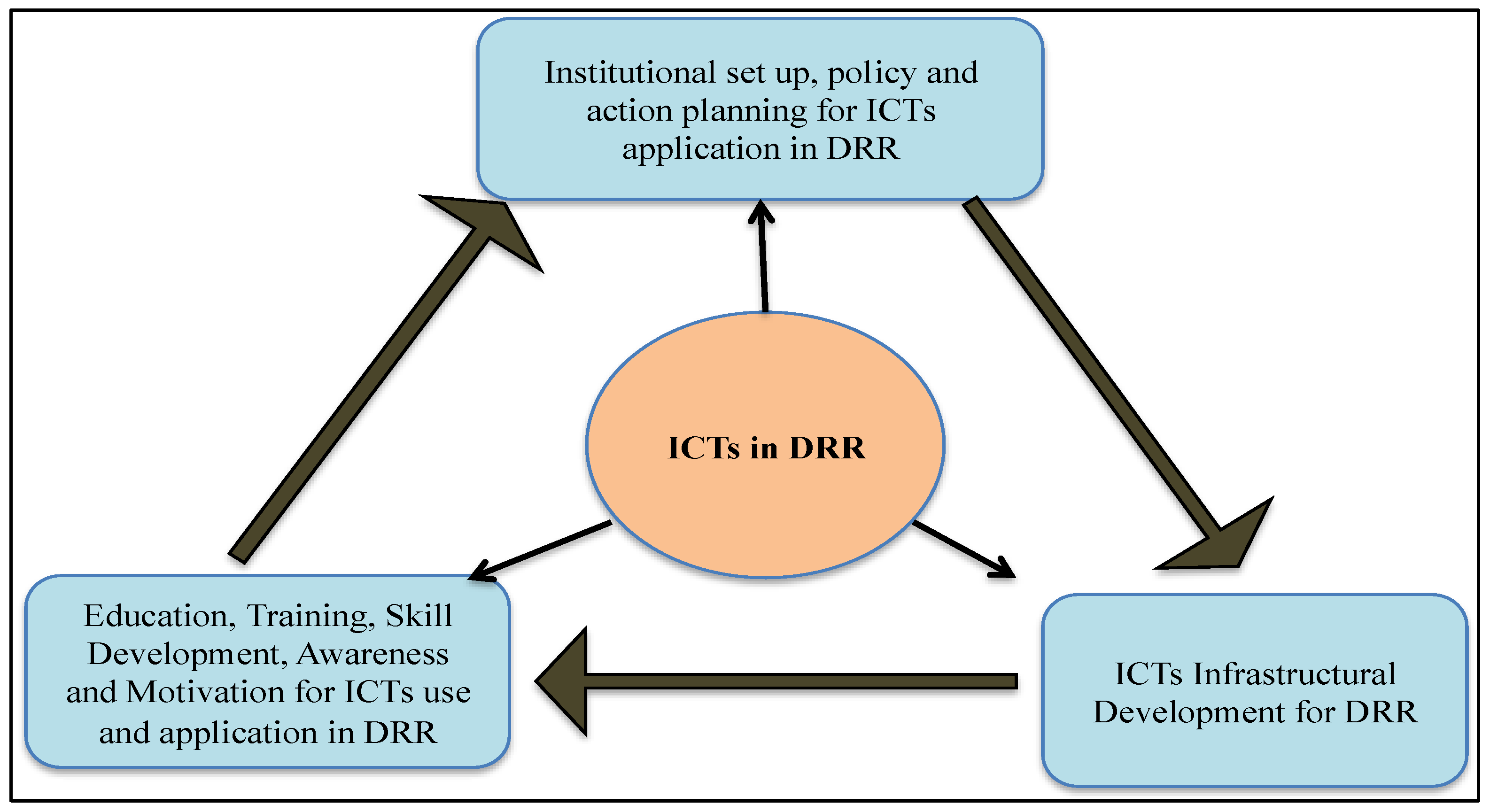
This study conducted interviews with key informants and focus group discussions on exploring the challenges in the use and application of ICT in the study area for flash flood management and risk reduction. Among the different challenges, some were at the individual or community level, while others were associated with the institutional level and/or national development initiatives and actions. The current study identified the following main challenges, as highlighted in Table 6.

4. Discussion

Based on the present study and previous reports, flash floods hit almost every year in the study area [21] and cause a devastating situation for the livelihoods of thousands of farmers [27]. A previous study also reported that the variety of information provided by ICT is beneficial to all communities [28]. The use of ICT and its application to mitigate the devastating effects of flash floods by early forecasting has also been reported in several reports [2,7], but the present study highlighted that people in the study area are faced different constraints in using and applying ICT applications in their flood risk reduction and management. It has already been reported that information literacy is important in recognizing people’s information needs, locating and evaluating the quality of information, storing and retrieving information, and making effective and ethical use of information [29]. One of the main constraints was identified as the remoteness of the study area. Prior research recognized the difficulties in communicating disaster alerts to people using cellular phones and radio broadcasts, as some locations have very poor radio and cellular phone reception [30].
In 2004, one study identified different challenges in the use and application of ICT in developing countries [31]. However, Bangladesh today still has not eliminated most of those challenges, with the current study identifying that they continue to exist in Bangladesh. Similar to our findings regarding the challenges of using ICT in flash flood management, prior research has considered that the two main components of ICT are computers and the Internet [32]. Due to this unpredictable nature, at times, it becomes difficult to predict the exact time and extent of flooding, especially when using the limited ICT available at the institutional level in Bangladesh, which has also been reported by Martins [33]. According to key informants and focus group discussions with local communities, local-level sub-district (upazila) officers were also not sufficiently skilled to apply different types of ICT for flash flood risk prediction, forecasting, and management. However, as one goal of ‘Digital Bangladesh’, the Bangladeshi government has proposed an assessment of ICT skills in public service entrance exams [6]. Moreover, prior research has recommended that efficient manpower and secure communications infrastructure is a precondition for successful ICT applications and development [34].
Although it is difficult to diminish the extent of flash floods due to their sudden nature and the geomorphological characteristics of the haor area, local authorities and communities need to be well prepared to reduce risks and to manage flash floods efficiently. Efficient risk management demands effective and efficient ICT use and applications. Zubairi and Idwan [35] support the view that in any mass disaster situation, such as a building collapse, earthquake, or flash flood, chaos and unmanageable situations may make it difficult to save lives. Better and more modern ICT can minimize these problems. For this to occur, however, constraints in ICT use and applications need to be eliminated.
Analysis of ICT use, constraints, and challenges in flash flood management reveals that education, training, skill development, and awareness, as well as infrastructural development, are needed to ensure ICT applications for effective DRR, thus demanding that a coordinated approach is used in the institutional set-up (Figure 4). The current study has identified illiteracy, poor quality of life, and poor social capital as some of the prime constraints that need to be prioritized in national ICT policy actions. Furthermore, other studies have advocated not only developing infrastructure but also educating people before the Internet becomes available and popular in targeted areas [28]. Scholars have also claimed that ICT can facilitate inter-village communication and community participation, bringing about positive outcomes for local communities at least at an early stage of diffusion.
Therefore, it can be expected that the constraints restricting ICT use and applications could be eliminated by enhancing ICT services and products. Moreover, the impacts of flash floods and ICT use and constraints in flash flood risk reduction are not the same in all areas. Therefore, the characteristics of the location, the extent of flash flood impacts, the use of ICT, and the nature of constraints and challenges in applying ICT need to be emphasized in the efforts and policy actions of the ‘Digital Bangladesh by 2021’ vision. Although the government has considered ICT as an important component in policy action for digital Bangladesh, the sectoral-based (ICT in DRR) implementation has not been started yet at the local and community level. The government has allotted a significant amount of budget at national level, and they are planning to work in close cooperation with the non-government organizations and local community peoples to develop disaster resilient community in the Haor areas of Bangladesh. We strongly believe that our findings on the role of ICT in flash flood management will help the government and policy makers in the development of an ICT-based flash flood resilient community by providing early warning among the local level community people.
In conclusion, the present study highlighted that poor quality of life, poor social capital, poor infrastructure, and poor communication with institutions are highlighted as the main constraints and challenges in the effective application of ICT in flash flood management. The findings from this study will contribute to the policy making for mitigating the flash flood risk in the haor areas of Bangladesh. In comparison to previous research findings, this study contributes new knowledge on ICT’s role in flash flood management in haor areas of Bangladesh. However, the use of mobile phones is common for communication during disasters. From the FGD and KII, it is evident that television, radio, and mobile phones can be used as the best resource for early warning in flash flood management in Haor areas of Bangladesh. Thus, ICT-based flash flood management should be implemented in Haor areas of Bangladesh directly by the government and local administrations. The findings can also be implemented in different regions across the globe for efficient flash flood risk management by customizing based on local context. Further research should focus on the performance evaluation for ICT-based flash flood risk management and the technological development of locally customized and user-friendly early warning systems.

Supplementary Materials

The following supporting information can be downloaded at: https://www.mdpi.com/article/10.3390/su14138018/s1.

Author Contributions

Conceptualization, M.A.A. and G.A.P.; methodology, M.A.A.; software, G.A.P.; data collection, U.H., M.G.K. and M.A.A.; formal analysis, G.A.P.; investigation, U.H.; writing—original draft preparation, G.A.P. and M.A.A.; writing—review and editing, M.G.K., R.A., M.I.K., A.G. and K.O.; supervision, M.M.R., M.I.K. and A.G.; project administration, M.M.R.; funding acquisition, M.M.R., M.I.K. and A.G. All authors have read and agreed to the published version of the manuscript.

Funding

This research was funded by SATREPS (0510000000023) (funded by JST-JICA) through ‘Research on Disaster Mitigation against Storm surges and floods in Bangladesh’, and partially funded by Researchers Supporting Project number (TURSP-2020/74), Taif University, Taif, Saudi Arabia.

Data Availability Statement

The data are available upon reasonable request from the corresponding author.

Acknowledgments

The authors acknowledge the support received for conducting this research from the Science and Technology Research Partnership for Sustainable Development (SATREPS) Project titled “Research on Disaster Prevention/Mitigation Measures against Floods and Storm Surges in Bangladesh”. The authors would like to extend their sincere appreciation to the Researchers Supporting Project number (TURSP-2020/74), Taif University, Taif, Saudi Arabia.

Conflicts of Interest

The authors declare no conflict of interest.

References

  1. Shabajee, P.; Fairbrother, M.; Dewsbury, J.D.; Preist, C. ICT 4 climate change adaptation: Systemic and generative perspectives & tools. In ICT for Sustainability (ICT4S-14); Atlantis Press: Amsterdam, The Netherlands, 2014; pp. 248–257. [Google Scholar]
  2. Kelvin, O.K.; Innocent, K. ICT in disaster risk reduction: The Kenyan experience. Int. J. Disaster Manag. Risk Reduct. 2012, 4, 44. [Google Scholar]
  3. United Nations Asian and Pacific Training Centre for Information and Communication Technology for Development (UN-APCICT). ICT for Disaster Risk Reduction Report 2010. pp. 28–40. Available online: https://core.ac.uk/download/pdf/61806512.pdf (accessed on 11 July 2021).
  4. Wattegama, C.; United Nations Asian and Pacific Training Centre for Information and Communication Technology for Development (UN-APCICT). ICT for Disaster Management Report 2007. pp. 22–26. Available online: http://www.unapcict.org (accessed on 2 June 2022).
  5. Shafiq, F.; Ahsan, K. An ICT based early warning system for flood disasters in Pakistan. Res. J. Recent Sci. 2014, 2277, 2502. [Google Scholar]
  6. Aziz, A. Digital inclusion challenges in Bangladesh: The case of the National ICT Policy. Contemp. South Asia 2020, 28, 304–319. [Google Scholar] [CrossRef]
  7. Zaman, A.M.; Biswas, A. Application of ICT Tools for Climate Change and Disaster Management in Bangladesh. In Proceedings of the AFITA (Asian Federation of Information Technology in Agriculture), Perth, WA, Australia, 29 September–2 October 2014; pp. 548–562. [Google Scholar]
  8. Mallick, B.; Ahmed, B.; Vogt, J. Living with the risks of cyclone disasters in the south-western coastal region of Bangladesh. Environments 2017, 4, 13. [Google Scholar] [CrossRef]
  9. Yazdani, M.; Mojtahedi, M.; Loosemore, M.; Sanderson, D. A modelling framework to design an evacuation support system for healthcare infrastructures in response to major flood events. Prog. Disaster Sci. 2022, 13, 100218. [Google Scholar] [CrossRef]
  10. Uddin, K.; Matin, M.A. Potential flood hazard zonation and flood shelter suitability mapping for disaster risk mitigation in Bangladesh using geospatial technology. Prog. Disaster Sci. 2021, 11, 100185. [Google Scholar] [CrossRef]
  11. Hagen, G.S.; Cutler, A.; Trambauer, P.; Weerts, A.; Suarez, P.; Solomatine, D. Development and evaluation of flood forecasting models for forecast-based financing using a novel model suitability matrix. Prog. Disaster Sci. 2020, 6, 100076. [Google Scholar] [CrossRef]
  12. Mikio, I.; Sasaki, D. Investing in flood protection in Asia: An empirical study focusing on the relationship between investment and damage. Prog. Disaster Sci. 2021, 12, 100197. [Google Scholar]
  13. Kamal, A.M.; Shamsudduha, M.; Ahmed, B.; Hassan, S.K.; Islam, M.S.; Kelman, I.; Fordham, M. Resilience to flash floods in wetland communities of northeastern Bangladesh. Int. J. Disaster Risk Reduct. 2018, 31, 478–488. [Google Scholar] [CrossRef] [Green Version]
  14. Bangladesh Water Development Board (BWDB). Annual Flood Report, Flood Forecasting and Warning Centre, Processing and Flood Forecasting Circle; Bangladesh Water Development Board: Dhaka, Bangladesh, 2014; p. 90. [Google Scholar]
  15. Sakurai, M.; Murayama, Y. Information technologies and disaster management–Benefits and issues. Prog. Disaster Sci. 2019, 2, 100012. [Google Scholar] [CrossRef]
  16. Parvin, S. Integrations of ICT in education sector for the advancement of the developing country: Some challenges and recommendations-Bangladesh perspective. Int. J. Comput. Sci. Inf. Technol. 2013, 5, 81. [Google Scholar] [CrossRef]
  17. Khan, S. A model for integrating ICT into teacher training programs in Bangladesh based on TPCK. Int. J. Educ. Dev. 2014, 10, 3. [Google Scholar]
  18. Ziemba, E. The contribution of ICT adoption by local governments to sustainability—Empirical evidence from Poland. Inf. Syst. Manag. 2021, 38, 116–134. [Google Scholar] [CrossRef]
  19. Ziemba, E. The contribution of ICT adoption to sustainability: Households’ perspective. Inf. Technol. People 2018, 32, 731–753. [Google Scholar] [CrossRef]
  20. Ziemba, E. The contribution of ICT adoption to the sustainable information society. J. Comput. Inf. Syst. 2019, 59, 116–126. [Google Scholar] [CrossRef]
  21. Akhter, H.; Mia, C.; Panna, S.A. Understanding the Changes of the Wetland Ecosystem, and Its Impact on the Biodiversity of Tanguar Haor in Sunamganj. Bangladesh Asian J. Environ. Ecol. 2018, 12, 1. [Google Scholar] [CrossRef]
  22. Wikipedia. Available online: https://en.wikipedia.org/wiki/Haor (accessed on 26 March 2021).
  23. Department of Agricultural Extension (DAE). District Report Sunamganj; DAE: Dhaka, Bangladesh, 2017. [Google Scholar]
  24. Aldhshan, S.R.; Mohammed, O.Z.; Shafri, H.M. Flash flood area mapping using sentinel-1 SAR data: A case study of eight upazilas in Sunamganj district, Bangladesh. In IOP Conference Series: Earth and Environmental Science; IOP Publishing: Bristol, UK, 2019; Volume 357, p. 012034. [Google Scholar]
  25. Center for Environmental and Geographic Information Services (CEGIS). Master Plan of Haor Area: Summary Report. In Bangladesh Haor and Wetland Development Board; Ministry of Water Resources, Government of Bangladesh: Dhaka, Bangladesh, 2012. [Google Scholar]
  26. USAID. Disaster Occurrence: Number of Natural Disasters Registered in EMDAT. 2007. Available online: http://www.unisdr.org/disaster-statistics/occurrence-trends-century.htm (accessed on 18 February 2009).
  27. Ferdushi, K.F.; Ismail, M.; Kamil, A.A. Perceptions, Knowledge, and Adaptation about Climate Change: A Study on Farmers of Haor Areas after a Flash Flood in Bangladesh. Climate 2019, 7, 85. [Google Scholar] [CrossRef] [Green Version]
  28. Onitsuka, K.; Hidayat, A.R.; Huang, W. Challenges for the next level of digital divide in rural Indonesian communities. Electron. J. Inf. Syst. Dev. Ctries 2018, 84, e12021. [Google Scholar] [CrossRef] [Green Version]
  29. Tilvawala, K.; Myers, M.D.; Andrade, A.D. Information literacy in Kenya. Electron. J. Inf. Syst. Dev. Ctries 2009, 39, 1. [Google Scholar] [CrossRef] [Green Version]
  30. Kang, B.; Choo, H. A Deep-Learning-Based Emergency Alert System. ICT Express 2016, 2, 67–70. [Google Scholar] [CrossRef] [Green Version]
  31. Ndou, V.E. Government for developing countries: Opportunities and challenges. Electron. J. Inf. Syst. Dev. Ctries 2004, 18, 1–24. [Google Scholar] [CrossRef]
  32. Leino, K. The Relationship between ICT Uses and Reading Literacy: Focus on 15-Year-Old Finnish Students in PISA Studies. Ph.D. Thesis, University of Jyvasklya, Jyväskylä, Finland, 2014. [Google Scholar]
  33. Martins, B.; Nunes, A.; Lourenço, L.; Velez-Castro, F. Flash flood risk perception by the population of Mindelo, S. Vicente (Cape Verde). Water 2019, 11, 1895. [Google Scholar] [CrossRef] [Green Version]
  34. Yan, Y.; Qian, Y.; Sharif, H.; Tipper, D. A survey on smart grid communication infrastructures: Motivations, requirements, and challenges. IEEE Commun. Surv. Tutor. 2012, 15, 5–20. [Google Scholar] [CrossRef] [Green Version]
  35. Zubairi, J.A.; Idwan, S. Smart algorithms for patient assignment in disasters. ICT Express 2018, 4, 107–111. [Google Scholar] [CrossRef]
Figure 1. Conceptual framework or layout of the present study.
Sustainability 14 08018 g001
Figure 2. Study area showing Tahirpur and Bishwamvarpur upazilas in the Sunamganj district, north-eastern Bangladesh.
Sustainability 14 08018 g002
Figure 3. Flash flood 2017: images showing impacts on the study area.
Sustainability 14 08018 g003
Figure 4. Coordinated approaches required for ICT applications in disaster risk reduction (DRR).
Sustainability 14 08018 g004
Table 1. Data collection methodology used in this study.
Data Collection ApproachCollected Data/VariablesRespondents
Semi-structured questionnaire survey at community levelDemographic and socio-economic information related to gender, age, education, occupation, and type and location of house
Flash flood impact-related information (impact on livelihood, food security, agriculture, health, water supply, and sanitation)
Use of ICT modes (television, telephone, mobile phone, broadcast radio, Facebook, etc.)
Household head in each of the two upazilas was the respondent
Focus group discussion (FGD) and interviews with key informantsConstraints and challenges in ICT use and/or applicationsHeld in each of the two upazilas: about 15–20 people attended the discussion. Key informants, such as an agriculture officer, upazila officials, and local leaders, were interviewed
Table 2. Socio-economic characteristics of the respondents from the study area.
Socio-Economic ParametersSunamganj District
Tahirpur UpazilaBishwamvarpur Upazila
% of Respondents% of Respondents
Gender
Male7085
Female3015
Age
Young (<25 years)1015
Middle-aged (26–50 years)6560
Old (>50 years)2525
Education level
Illiterate1020
Primary school4550
Secondary school3525
College55
Graduate50
Occupation
Agriculture3065
Services305
Business105
Day labor520
Other (fisherman, rickshaw puller, boatman)255
Location of house
Bank of river2010
Bank of haor6530
Roadside1560
Type of house
Pacca2055
Semi-pacca355
Katcha4540
Note: pacca—brick and concrete; semi-pacca—brick, mud, and tin sheet; katcha—bamboo, mud, and rice straw.
Table 3. Impacts of flash floods in study area (% of respondents).
ParametersTahirpurBishwamvarpurPearson’s Chi-Square: Significance Level
YesNoYesNo
Agriculture90109550.298
Livelihood *356515850.011
Fisheries *158501000.002
Livestock208020801.000
Food security356525750.232
Safe drinking water *208050500.001
Sanitation406055450.100
Health257515850.171
Education15855950.068
Migration455550500.583
Settlements *109001000.012
Infrastructure *35655950.000
Note: Parameters with * symbol denote parameters that significantly vary in the two upazilas. Significance levels calculated by Pearson’s chi-square test are shown in the last column.
Table 4. Types of ICT used in flash flood risk reduction (% of respondents).
ICT ModesTahirpurBishwamvarpurp-Value and Significance Level
Television *90750.053
Mobile phone *60300.002
Broadcast radio *2380.043
Facebook *2300.000
Telephone *3000.000
Note: ICT modes marked with * have significant variation in uses in the two studied upazilas.
Table 5. Community constraints in using ICT for flash flood risk reduction (% of respondents).
Types of ConstraintsTahirpurBishwamvarpur
Lack of quality of life * (0.019)1535
Illiteracy * (0.000)9040
Access and transportation3035
Located in remote area5543
Poor communication with institutions * (0.079)3015
Lack of training1510
Lack of willingness to adopt ICT 2011
Poor awareness about flash flood response4030
Poor social capital * (0.053)2510
Note: Multiple responses are considered here. Constraints marked with * show significant variation between the two upazilas. Values inside the first column bracket indicate the level of significance.
Table 6. Challenges in using ICT for flash flood risk reduction (% of respondents).
Types of ChallengesTahirpurBishwamvarpur
Unavailability of logistics to support ICT at individual or household level 8070
Unpredictable nature of flash floods9590
Lack of professionalism and skilled manpower5560
Failure of power supply9080
Poor Internet facility infrastructure and maintenance5540
Publisher’s Note: MDPI stays neutral with regard to jurisdictional claims in published maps and institutional affiliations.

