Abstract
To study the landslide risk of high-altitude and cold stope slopes, the slope deformation index and landslide risk standards at home and abroad for many years were analyzed and summarized. Using the unascertained measurement model, combined with the analytic hierarchy process, using the Dongbang slope of the Beizhan Iron Mine in Hejing County, Xinjiang, as the research object, the detailed geological data of the slope were obtained, and nine factors affecting the landslide risk of the slope were analyzed. When calculating the weight of each factor, the actual situation of the slope was used as the standard, and the weight of each factor was determined by the analytic hierarchy process. Then, the undetermined measurement matrix of the slope was determined by the statistical method combined with the expert scoring results. Finally, an unconfirmed measurement model for landslide risk grade evaluation of the Dongbang slope of the Beizhan Iron Mine was formed, and the landslide risk monitoring grade evaluation was carried out on the slope in the cold area. The results show that the landslide risk monitoring level of the Dongbang slope in Beizhan Iron Mine is grade II, which indicates that there is a possibility of mild landslide risk for the slope in this cold area. The research results can provide a reference for the risk level and risk assessment of high-altitude alpine slopes.
1. Introduction
China is one of the countries in the world with fragile geological environments and frequent landslide disasters [1]. At the same time, China is also one of the countries with large areas of high altitude and cold areas. Slope landslides in open-pit mines are a potential hazard, especially in the harsh environment of high-altitude cold areas. The rock mass of the slope is more susceptible to the impact of the harsh environment in producing sliding damage [2], resulting in the stability of the slope. Therefore, the landslide caused by slope instability restricts the development of the mineral resources mining industry in China’s high-altitude and cold regions. Due to the special characteristics of slopes in cold regions, the stability of the slopes is reduced [3], and the landslides caused by the instability of the slopes has become a large loss of property and personnel and is one of the world’s geological disasters [4,5,6,7]. The risk assessment of landslide disasters on slopes can provide safety warnings for slope landslides, thereby reducing the losses caused by landslide disasters, which has attracted attention [8].
The factors that affect slope landslides are often multifaceted, and the current system for determining the risk level of landslides is not perfect. In 1988, HH Enstein [9] presented a framework for landslide hazard risk assessment; R. Anbalagan [10] and Bhawani Singh proposed landslide hazard risk assessment mapping based on mountain landslide hazard risk assessment mapping and zoning mapping research. New methods and a risk assessment matrix have also been developed. From the perspective of system theory, XieQuanmin et al. [11] proposed and systematically explained the system theory of landslide disaster risk assessment with landslide risk analysis, disaster-bearing body vulnerability analysis and landslide disaster damage loss assessment as the core content. In recent years, scholars such as Wang Hao, Tang Xubo, Wu Yue, Pan Xiaocheng, Tang Fuquan, and Yang Songyue [12,13,14,15,16,17,18,19] have separately compared the information volume model, the information volume method model and GIS technology, the spatial disaster probability method, the fuzzy comprehensive evaluation method, and the Monte Carlo method. Methods such as Lofa, GIS and the analytic hierarchy process (AHP) were applied to the slope risk assessment and achieved certain results. However, due to the freeze–thaw cycle under high-altitude and high-cold conditions, the factors affecting the instability of landslides in cold areas are more complicated than those in non-high altitude and high-cold conditions. For cold areas, more in-depth research is needed for stability research.
Landslide risk assessment can provide an important basis for formulating disaster prevention and mitigation measures and has guiding significance for landslide disaster mitigation planning and economic construction in disaster-stricken areas [20]. Based on the iron-bearing deposits being developed by Xinjiang Hejing County Beizhan Mining Co., Ltd., this paper conducts a comprehensive analysis and research on the factors affecting slope landslides. Based on existing research, the freeze–thaw cycle factors under high-altitude and high-cold conditions are integrated to comprehensively judge the landslide risk level of stope slopes in cold areas [21,22,23,24]. The disaster mechanism of a high-cold freeze-thaw slope is shown in Figure 1.
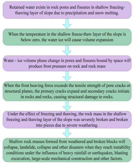
Figure 1.
Disaster mechanism of a high-cold freeze–thaw slope.
2. Study Area
The effective evaluation of slope landslide risk is one of the important contents of current world disaster prevention and mitigation work. Slope landslide safety evaluations are the embodiment of the real-time condition of the slope body and the prediction of the development trend of the slope body for a period of time in the future. According to the development of the slope body, specific disaster prevention measures are formulated, which is very important for the safe mining of the mine slope. However, due to the freeze–thaw cycle under high altitude and high-cold conditions, the influential factors of slope instability and landslides in cold areas are more complex than those of slope landslides under normal temperature conditions. To date, there are relatively few studies on slope instability and landslides in cold regions. A traffic location map of the Beizhan Iron mine is shown in Figure 2, and an open pit plan of the Beizhan Iron mine is shown in Figure 3.
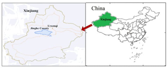
Figure 2.
Traffic location map of the Beizhan Iron mine.
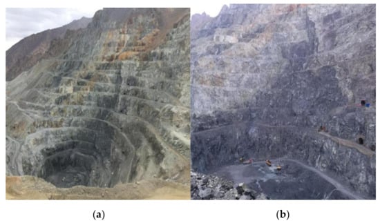
Figure 3.
Open pit plan of the Beizhan Iron mine. (a) Overall, (b) Partial.
3. Evaluation Model
3.1. Analysis of Slope Deformation Index in Cold Areas
Based on the iron-bearing deposits being developed by Xinjiang Hejing County Beizhan Mining Co., Ltd., this paper conducts a comprehensive analysis and research on the factors affecting slope landslides in cold regions. Based on existing research, the freeze–thaw cycle factors under high-altitude and high-cold conditions are integrated to comprehensively judge the landslide risk level of stope slopes in cold areas.
According to the national safety monitoring technical specifications, the formula for calculating the slope deformation index of an open-pit mine stope is shown in Equation (1):
where D is the deformation index;
H—Height index;
A—grade index;
G—Geological condition index.
The slopes of high-altitude and high-cold stopes will be affected by freeze–thaw cycles for a long time due to the harsher geographical conditions. For rock slopes, the freeze–thaw action will cause the formation of water in the pores of the rock mass. A cyclic process of freezing-melting-refreezing-remelting occurs. In this process, the water in the pores will produce frost heave, increase the volume, and destroy the rock structure. This has a certain influence on the geological condition index of the slope, which leads to the instability of the slope and the occurrence of landslides. Therefore, it is necessary to introduce the freeze–thaw cycle coefficient ζ to modify the deformation index, and the modified calculation formula for the deformation index of the slope in the cold zone is shown in Equation (2):
The freeze–thaw cycle coefficient ζ is determined by the specific environment of the mine slope. The slope rock is sampled, and then the mechanical performance data of the rock are obtained from the freeze–thaw cycle test to determine the freeze–thaw cycle coefficient ζ of the slope.
3.2. Analysis of Risk Factors for Slope Landslides in Cold Areas
Based on the research on the definition of slope landslide risk proposed by Varnes, domestic and foreign scholars have summarized the factor relationship of the influence of landslide risk, as shown in Equation (3):
where: R—risk of landslide; H—risk, which refers to the probability of the occurrence of a landslide; V—vulnerability of landslide body; E—value of landslide body; C—hazardousness, which refers to the consequences caused by a landslide, and is a function of vulnerability V and value E.
Combining (3), risks were the major influencing factors of landslide risk and harmfulness of two aspects, harmfulness associated with the economic value and the damage degree of slope; therefore, the influence factor of landslide risk can be divided into three aspects, namely, risk factor, slope factor, and degree of slope destruction factor value. The research on risk assessment of slope landslides at home and abroad is summarized. The main factors that affect slope landslides include slope, slope height, rock mass compressive strength, rock mass weathering degree, earthquake influence, groundwater, annual rainfall, artificial activities, and freezing and thawing cycles.
The influence of slope geometry on slope landslide risk is mainly shown in the following aspects: the higher the height and the steeper the slope, the more potential energy it contains. Therefore, the more easily the stability of the slope is destroyed, the greater the harm caused by the landslide. In addition, the lithology of the slope rock mass has a greater impact on the risk of landslides. The higher the strength of the rock itself, the higher the hardness, the higher the integrity of the rock, the stronger the ability to resist weathering, and the better the mechanical properties, such as the uniaxial compressive strength. The more resistant such a rock slope is to external forces, the lower the risk of unstable landslides. In contrast, if its strength is not high, its mechanical properties are poor, and it is easy to break. Such a rocky slope under the action of an external force is easy to destabilize, resulting in slope landslides and other disasters. In the natural state of the slope, the internal potential energy and stress field are kept in a stable state. Only when the internal stress field is seriously unbalanced under the induction of an external force will slope instability and landslides be induced. There are many inducing factors of slope instability landslides, including natural forces and non-natural forces. Among the natural forces, the most significant is the effect of earthquakes, which can cause the destruction of slope rock masses, thus causing the destruction of slope stability and inducing slope slides. In addition, the effect of rainwater will also affect slope landslides; meteoric precipitation will produce erosion effects on the surface soil, rock, and vegetation of the slope, resulting in slope stability reduction. Minerals contained in the groundwater can corrode the rock, causing damage to the internal structure of the rock mass, so the impact of rain on the risk of slope landslides cannot be ignored. Artificial activities are the main non-natural inducing factors that lead to slope landslides. For mines, frequent blasting mining and mining activities with large machinery operations will damage the integrity of the slope rock mass and cause a serious imbalance of the stress field of the slope rock mass, thus inducing landslide disasters. In addition to the conventional influencing factors mentioned above, the rock mass of the slope in the cold region is affected by the freeze–thaw cycle year-round, and its mechanical properties will be damaged to a certain extent, which may also lead to the occurrence of landslides. Therefore, the impact of the freeze–thaw cycle factor on the slope landslide risk should be considered. A total of nine influencing factors jointly determine the slope landslide risk in cold regions.
3.3. Computational Theories of Unascertained Measure Models
Assume that the object A to be evaluated has N impact factors (i.e., indicators) A1, A2, …, an; then, we can write the object as A = {a1, a2, …, an}. Each impact factor Ni (I = 1, 2, …, n) has P rating levels: E1, E2, …, EP, and they all have E1, >, E2, >, …, >ep, P = {e1, e2, …, ep}.
(1) Determine the unascertained measure matrix
According to the enterprise scoring method or induction method, each impact factor of the evaluation object is graded, where aij represents the observed value of indicator ai on the JTH evaluation level ej (j = 1, 2, …, p) and is the score. The observed value obtained is normalized, and Uij = aij/100 represents the unascertained measure of the impact Factor I, so Uij ={ai1, ai2, aip} (I = 1, 2, …, n). Uij is the unascertained measure matrix, as shown in Equation (4).
(2) Determine index weights
Each influence factor of the evaluation object relative to its importance degree is not completely the same, so the weights determine the influence and importance of the analytic hierarchy process (ahp). The research object of evaluation analysis is influenced systematically by many factors and the calculation results are also very clear, so it is reasonable to determine the weights of the affecting factors. The specific calculation steps are shown in Figure 4 (bij is the importance degree of bi and bj relative to the element at the higher level).
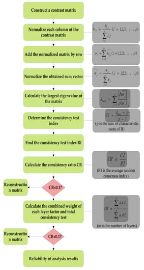
Figure 4.
AHP weight calculation step diagram.
Let Uk = U(ai ∈ ek) be the degree to which each impact factor of the evaluation object is at the k-th evaluation level, as shown in Equations (5) and (6):
Obviously, 0 ≤ Uk ≤ 1 and .
3.4. Evaluation of Risk Monitoring Level of Slope and Landslides in Cold Areas
(1) Establishing the evaluation model of slope landslide risk monitoring grade in cold areas
Through specific analysis of the influencing factors of slope landslide risk in cold areas, nine influencing factors (namely, indicators) were determined. Therefore, a risk monitoring grade evaluation model for slope landslides in cold areas can be established, as shown in Figure 5.
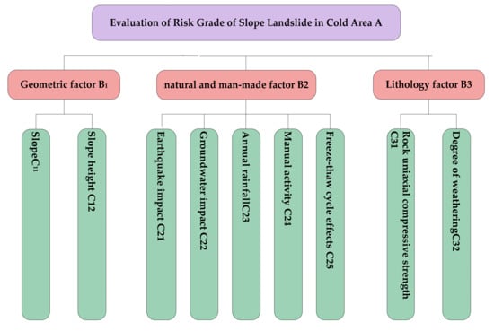
Figure 5.
Slope landslide risk grade evaluation model diagram in cold regions.
(2) Determining the weight
The AHP method is used to determine the weights of various indicators in the unascertained measurement model of slope landslide risk monitoring grade evaluation in cold areas. Based on information such as on-site engineering conditions of high altitude and cold stope slopes, combined with expert scoring results, a comparison matrix A, B1, B2, B3, B4 is constructed, as shown below.
From this, the weights of the criterion layer to the target layer and the index layer to the criterion layer can be calculated, and then the consistency is checked. The calculation results are shown in Table 1.

Table 1.
Impact factor index weight.
After obtaining the weights of the various indicators at each level, the consistency test of each matrix is carried out. First, according to Formula (7):
The value of CI is calculated and compared with the random consistency index RI. The value of RI is shown in Table 2.

Table 2.
RI value table.
Only when the random consensus ratio is can the judgement matrix be established; otherwise, the judgement matrix will have to be adjusted. The matrix consistency test of the target layer to the criterion layer is as follows:
λ1max = 3.1078, CI = 0.054, RI = 0.58, CR = 0.093 < 0.1;
Criterion layer to index layer matrix consistency test:
λ2max = 2, CI = 0, RI = 0;
λ3max = 5.2896, CI = 0.072, RI = 1.21, R = 0.060 < 0.1;
λ4max = 2, CI = 0, RI = 0.
From the above calculation results, each judgement matrix has passed the consistency test, so the constructed judgement matrix is effective and reasonable, and the weight vector can be calculated continuously:
(3) Determining the unascertained measure matrix
To ensure the accuracy of the classification of each influencing factor and reduce the error of each link, the classification should be divided into as few levels as possible to reduce the influence of subjective factors. With reference to the research on slope and landslide risk monitoring levels at home and abroad, the risk levels are divided into four levels: Level I: no risk; Level II: mild risk; Level III: moderate risk; and Level IV: high risk. See the classification standards t in Table 3.

Table 3.
Landslide risk grade classification standard table.
Through the understanding of the actual measurement data of the slope in the cold area of the iron mine and the survey of 100 people, including the management, employees and experts of the mining enterprise, the scoring results were obtained, and then the average scoring table was summarized, as shown in Table 4.

Table 4.
Rating results.
The unascertained measure matrix can be obtained by using the Formula (4) unascertained measure matrix calculation method, as shown in Formula (8).
Combining the calculation results of the weights, the final comprehensive measurement evaluation vector can be obtained by applying Formula (9):
4. Results and Discussion
According to the calculation theory and principle of the unascertained measure model, the maximum value of the comprehensive measure evaluation vector finally obtained is 0.449, and the corresponding landslide risk monitoring evaluation level is level II, indicating that there is a slight landslide risk on the slope in the cold area. The calculations show that among the nine factors that affect the risk of slope landslides in this cold area, the main factors leading to the risk of mild landslides should be the uniaxial compressive strength in the lithological factors and the freezing in the natural and man-made factors.
First, the main body of the landslide is the slope body, including the overlying soil body and the lower rock mass. The performance of the lower rock mass determines the slope’s ability to resist external force intrusion. When the rock composing the slope has strong lithology and the rock mass structure is complete, the more stable the slope is, and the stronger the ability of the slope to resist the risk of landslides. Conversely, if the rock composing the slope has poor lithology, low uniaxial compressive strength, complex rock structure, well-developed cracks, and staggered structural surfaces, the slope’s ability to resist external force intrusion is very low, and it is easy to cause a landslide when induced by an external force. In addition, the slope height and gradient of the slope also have an important impact on the risk of slope landslides. The higher the height and the steeper the slope, the greater the potential energy contained in the slope. In the original state, the internal energy of the slope is in a balanced state. Under the action of external forces (such as excavation, blasting, etc.) and activities (such as earthquakes and other natural effects), the internal mechanical balance of the slope is disrupted, which will release extremely powerful energy, resulting in a landslide. Therefore, the higher the height and the steeper the slope, the more likely it is that energy released after breaking the mechanical balance will cause landslides to occur. There are various lithologies distributed from south to north on the eastern slope of the iron mine. They are monzonite porphyry-skarn ore body-skarn marble-limestone. In the marble and limestone, the poor lithology and low compressive strength of the rock are important factors leading to the risk of landslides. However, the structural surface of the rock mass of the entire slope is relatively complete, which makes up for some of the deficiencies in lithology. The vertical height of the slope has reached more than 300 meters, and the slope is greater than 50°. It is a typical steep slope. Therefore, its geometry is also an important factor in the risk of mild landslides. Finally, the unique freeze–thaw cycle effect of the slope in the cold area cannot be ignored. Although its effect is negligible from a momentary point of view, the strength of the slope in the cold area will be severely damaged under the action of many years. The freeze–thaw cycle effect means that the water in the rock pores will form an infinite cycle of solidification-melting-solidification during the temperature transition of the slope in the cold area throughout the year. On the one hand, during this process the abnormal cold expansion and heat shrinkage properties will produce a frost heaving force to destroy the original pores and form larger pores due to the water in the pores, resulting in the deterioration of the rock mechanical properties of the slope, thereby increasing the risk of slope landslides. On the other hand, the water will gradually erode deep into the slope after it melts when the temperature rises. After a certain depth, the water will increase, and the friction of the rock will weaken, which is equivalent to the separation between the rock surface and the seepage layer and the interior of the slope. The former is the combination of rock, soil, and water that is easily damaged by external forces, which can lead to landslides. Therefore, the freeze–thaw cycle of slopes in cold regions is an extremely important factor affecting slope landslides. It is precisely because of the abovementioned leading factors that there is a possibility of a slight landslide risk on the slope in this cold area, and finally, the landslide risk level of the slope in this cold area is calculated as Grade II.
5. Conclusions
Using a mining company as an example, based on an unascertained theoretical model, 16 impact factors were selected to establish an unascertained measurement model for safety standardized operation, and finally, the safety standardized operation level of the mine was obtained. The result verified the applicability of the model. This paper uses an unascertained measurement model, combined with the analytic hierarchy process, to take the slope of the east side of the Beizhan Iron Mine in Xinjiang Hejing County as the research object, investigates and obtains detailed geological data of the slope, and analyzes the results. Nine factors that affect the landslide risk of the slope are considered. When calculating the weight of each factor, the actual conditions of the slope are taken as the standard, and the analytic hierarchy process is used to determine the weight of each factor. Then, using statistical methods, combined with expert scoring results, the unascertained measure matrix of the slope is determined. Finally, an unascertained measurement model was formed for the landslide risk level evaluation of the eastern slope of the iron mine, and the landslide risk monitoring level evaluation was performed on the slope in the cold area.
- The long-term freeze–thaw cycle will inevitably affect the slope’s geological condition index, which will lead to slope instability, so it is appropriate to introduce the freeze–thaw cycle coefficient ζ to correct the slope deformation index in cold regions.
- The factors affecting the risk of landslides in cold regions are slope, slope height, groundwater, earthquake, freeze–thaw cycle, uniaxial compressive strength of rock, and degree of weathering.
- The calculation results of the theoretical model of the calculation of the uncertain measurement show that the landslide risk monitoring level of the Dongbang slope is Class II, indicating that the slope in the cold area has the possibility of a slight landslide risk. The main factors leading to slight landslide risk should be the uniaxial compressive strength, freeze–thaw cycle effect, geometric factors, and lithology of the rock mass.
Author Contributions
Conceptualization, R.Z.; Formal analysis, R.Z.; Funding acquisition, R.Z.; Investigation, R.Z.; Methodology, S.W.; Project administration, S.W. and C.X.; Resources, C.X.; Software, C.X.; Visualization, Q.C.; Writing—original draft, Q.C. All authors have read and agreed to the published version of the manuscript.
Funding
The research was funded by the national key research and development project “Slope instability mechanism and early warning technology of open pit in high altitude and cold area” (No. 2018YFC0808402) and the Hunan Province Science Foundation, grant number “2021JJ30679”.
Institutional Review Board Statement
Not applicable.
Informed Consent Statement
Not applicable.
Data Availability Statement
All the data included in this study are available upon request by contact with the corresponding author.
Conflicts of Interest
The authors declare no conflict of interest.
References
- Pan, X.C.; Nie, R.S.; Luo, H.Y. Application of Fuzzy Comprehensive Evaluation in the Risk Assessment of Single Landslide. Soil Eng. Found. 2018, 32, 330–334. [Google Scholar]
- Meng, L.L.; Chen, Q.F. Stability analysis of high-altitude and high-cold slopes in preparation for the iron mine. Nonferrous Met. 2020, 72, 5–9. [Google Scholar]
- Li, J.F.; Wan, C. Evaluation of rock slope stability in high-cold and high-altitude areas. J. ChongqingJiaotong Univ. 2015, 34, 45–48. [Google Scholar]
- Fang, R.K.; Liu, Y.H. Review of regional landslide risk assessment methods based on machine learning. Chin. J. Geol. Hazard Control. 2021, 32, 1–5. [Google Scholar]
- Xie, C.Y.; Nguyen, H.; Bui, X.N.; Nguyen, V.T.; Zhou, J. Predicting roof displacement of roadways in underground coal mines using adaptive neuro-fuzzy inference system optimized by various physics-based optimization algorithms. J. Rock Mech. Geotech. Eng. 2021, 13, 1452–1465. [Google Scholar] [CrossRef]
- Shang, G.A. Analysis of dump slope deformation monitoring data based on the rescaled range analysis method. Opencast Min.Technol. 2018, 33, 64–67. [Google Scholar]
- Li, C.H.; Xiao, Y.G. Research status and trend of deformation failure mechanism of rock slopes in high altitude and cold area. Chin. J. Eng.Sci. 2019, 41, 1374–1386. [Google Scholar]
- Wu, Y.; Liu, D.S.; Lu, X.; Song, Q.H. A quantitative assessment model for property risk caused by single landslide. Rock Soil Mech. 2010, 31, 342–348. [Google Scholar]
- Einsten, H.H. Special lecture: Landslide risk assessment procedure. Proc. 5th. Int. Symp. Landslide Lausanne 1988, 2, 1075–1090. [Google Scholar]
- Anbalagan, R.; Singh, B. Landslide hazard and risk assessment mapping of mountainous terrains—A case study from kumaunhimalaya. India Eng.Geol. 1996, 43, 237–246. [Google Scholar] [CrossRef]
- Xie, Q.M.; Bian, X.; Xia, Y.Y. Systematic analysis of risk evaluation of landslide hazard. Rock Soil Mech. 2005, 26, 71–74. [Google Scholar]
- Wang, H.; Dou, H.Q. A technical framework for life cycle risk assessment and management of cutting slopes. Rock Soil Mech. 2017, 38, 3505–3514. [Google Scholar]
- Tang, X.B. Risk assessment of landslide in Shennongjia forest area based on information model. J. Water Resour. Archit. Eng. 2018, 16, 115–119. [Google Scholar]
- Wang, L.; Chang, M. Risk Assessment of Landslide Geological Hazard Based on Information Quantity Method Model and GIS. Geol. Hazards Environ. Prot. 2021, 32, 14–20. [Google Scholar]
- Wu, Y.; Xiang, L.J. Quantitative assessment of landslide disaster property risk based on the spatial probability of the affected body. Chin. J. Rock Mech. Eng. 2020, 39, 3464–3473. [Google Scholar]
- Liu, D.F.; Wang, X.S. Risk Assessment of Xieliu Slope Landslide in Zhouqu, Gansu Based on Reliability Analysis. J. Mt. Res. 2017, 35, 323–331. [Google Scholar]
- Shen, H.F.; Yang, J.L. Evaluation of landslide disaster risk and loss in Hunan Province based on GIS. Bull. Soil Water Conserv. 2020, 40, 146–151. [Google Scholar]
- Tang, F.Q.; Lu, J.X. Risk assessment of landslide disaster caused by mining in loess mining area. Coal Technol. 2018, 37, 123–125. [Google Scholar] [CrossRef]
- Yang, S.Y.; Weng, M.Z. Risk Assessment of Landslide Geological Hazards in the Urban Area of Hefeng County, Hubei Province. Saf. Environ. Prot. Eng. 2021, 28, 144–155. [Google Scholar]
- Li, Z.; Nadim, F.; Huang, H.; Uzielli, M.; Lacasse, S. Quantitative vulnerability estimation for scenario-based landslide hazards. Land-Slides 2010, 7, 125–134. [Google Scholar] [CrossRef]
- Xie, C.Y.; Nguyen, H.; Choi, Y.; Armaghani, D.J. Optimized functional linked neural network for predicting diaphragm wall deflection induced by braced excavations in clays. Geosci. Front. 2022, 13, 101313. [Google Scholar] [CrossRef]
- Zhang, R.; Wu, S.; Xie, C.; Chen, Q. Study on the Geological Condition Analysis and Grade Division of High Altitude and Cold Stope Slope. Sustainability 2021, 13, 12464. [Google Scholar] [CrossRef]
- Cui, G.; Zhang, Y.; Shi, F.; Jia, W.; Pan, B.; Han, C.; Liu, Z.; Li, M.; Zhou, H. Study of Spatiotemporal Changes and Driving Factors of Habitat Quality: A Case Study of the Agro-Pastoral Ecotone in Northern Shaanxi, China. Sustainability 2022, 14, 5141. [Google Scholar] [CrossRef]
- Sengani, F.; Allopi, D. Accuracy of Two-Dimensional Limit Equilibrium Methods in Predicting Stability of Homogenous Road-Cut Slopes. Sustainability 2022, 14, 3872. [Google Scholar] [CrossRef]
Publisher’s Note: MDPI stays neutral with regard to jurisdictional claims in published maps and institutional affiliations. |
© 2022 by the authors. Licensee MDPI, Basel, Switzerland. This article is an open access article distributed under the terms and conditions of the Creative Commons Attribution (CC BY) license (https://creativecommons.org/licenses/by/4.0/).