Article

Research on Traffic Design of Urban Vital Streets

1
School of Civil Engineering and Architecture, Wuhan Institute of Technology, Wuhan 430074, China
2
Wuhan Transportation Planning & Design Co., Ltd., Wuhan 430017, China
*
Author to whom correspondence should be addressed.
Sustainability 2022, 14(11), 6468; https://doi.org/10.3390/su14116468
Submission received: 22 April 2022 / Revised: 14 May 2022 / Accepted: 18 May 2022 / Published: 25 May 2022

Abstract

:
As an important part of urban public spaces, the urban street is an important place for people’s lives, communication, and activities. Its vitality directly affects the vitality of the whole city. It is of great practical significance to examine the current situation and theoretical development of urban streets in China and reconstruct the vitality of streets from the perspective of the traffic users. Based on the “people-oriented” design concept of street traffic, this study took street sections and intersections as the main research object, proposed an overall layout of traffic, space, and facilities. A complete set of humanized and green traffic design methods was constructed to enhance the street vitality. First, through the analysis of the concept of road and street, the traffic connotations of the vital street was determined, the characteristics of the vital street was investigated, and the constituent elements of the vital street was summarized. Then, with a focus on people’s needs, the vital street traffic design methods were mainly divided into two parts: vital street section traffic design and vital street intersection design. Finally, Zhongshan Avenue in Wuhan City was chosen for empirical analysis. Through a field questionnaire survey, the traffic characteristics and traffic demands of residents on Zhongshan Avenue were analyzed, and the traffic design of Zhongshan Avenue was carried out in combination with the traffic design method proposed in this study. The results showed that people’s satisfaction with the renovated Zhongshan Avenue reached 90%. Buses, subways, bicycles, and walkways have become the four major green transportation modes for people to arrive at and leave Zhongshan Avenue, and the renovated Zhongshan Avenue has become a vibrant living street.

1. Introduction

At present, the main social contradiction in China focuses on people’s growing needs for better lives and unbalanced and insufficient development. For example, people’s demand for street space has gradually shifted to the pursuit of high-quality street space and restoring street vitality. With the acceleration of urbanization, the vitality of original streets gradually decreased in the context of disordered urban construction. Urban roads were “car-based” and ignored the travel environment and the feelings of residents.
The basic design concept of vital streets is “people-oriented”. Its traffic connotation lies in an efficient, safe, healthy, and environmentally friendly green transportation system and a good, slow travel environment. Therefore, it has become important in urban development to design street traffic from the perspectives of being people-oriented and vital.
In the past, streets were public spaces that were crucial for our social, cultural, and economic needs [1,2]. With the passage of time, people rethought the street, regarding it not only as a means of transportation but also as a space with more functions [3]. The connotation of “vitality” was an important factor in defining vital streets. Neil Ravenscroft, a British scholar, believed that vitality was the degree of busyness in urban centers at different times and places [4]. Yi et al., regarded the vitality of urban streets as an urban landscape concept in describing the quality of urban space, and considered vitality on the basis of people’s subjective perceptions of urban environments [5]. Gehl proposed that street vitality referred to the people and activities that could be observed in a street space, and that a vital street was the product of the number and duration of various activities [6]. The vitality of the street is also closely related to urban design; Montgomery believed that taking social factors into account when designing a city can make the city more pleasant [7].
In the face of the continuous loss of street vitality, some street designers carried out substantial research. The first discussion on the vitality of urban streets took place in the 20th century. Some studies described the attributes related to street vitality from a qualitative perspective and identified the internal laws affecting spatial vitality [8]. This method provided less attention to the social attributes of streets and lacked the support of quantitative data.
At that time, quantitative research on street vitality and the factors that influenced it was in its infancy. The wide application of multi-source data provided strong support for the acquisition of street data. Cranshaw et al., used lBS data to analyze the temporal and spatial distribution of residents’ behavior in Pittsburgh, Pennsylvania. Based on this analysis, Pittsburgh was divided into nine types of living blocks with different characteristics [9]. Feick used mainstream pictures together with geographic data information to identify the aggregation of entertainment and tourism activities in urban street spaces in Vancouver [10]. Harvey used spatial data and spatial research methods to measure the suitability of streetscape designs in Boston, New York, and Baltimore [11]. Bell thoroughly analyzed the flow of public transport by collecting data on subway usage and public bicycle travel within a city [12].
In recent years, the correlation analysis method has been widely used in the research of street vitality. Nai and Zarin et al., used the method of multiple linear regression to study the influence of a street’s physical space environment and other factors on street vitality [13,14]. Xu et al. proposed that the time dimension had a certain impact on street vitality. In that study, nine streets with different ages in the old urban area, the main urban area, and the new urban area of Nanjing were selected, and factors such as street shape, street business type, and street accessibility were selected for analysis. The ranking method was used to rank and comprehensively analyze the impact of those factors. Xu et al. concluded that in different periods, street vitality in the new urban area was lower than that in the old urban area and the main urban area [15]. Samrat et al., investigated Boalisina street, one of the main streets of Hamadan, analyzed a model of the identifiable influencing factors on the vitality of this street, and concluded that factors such as security and user diversity had a great impact on the vitality and popularity of this street [16]. With the help of multi-source urban data, Yj et al., conducted a systematic analysis of 14 cities in China from the perspectives of top-down and human scale, and concluded from hierarchical regression analysis that functional characteristics had the greatest impact, followed by morphological characteristics and human scale characteristics [17].
For street design in different historical stages, people had different needs, including safety, accessibility, livability, openness, durability, and sustainability. Based on studies of street space attributes and the factors that influence street vitality, some scholars proposed to take the street as an extension of built space and design it into a safe, attractive, and shareable space [18,19]. Based on the “people-oriented” street design concept, Yang et al. selected four typical cities as examples and put forward the comprehensive framework of Chinese urban street design guidelines [20]. Mohammed suggested creating a shorter travel distance for pedestrians through the street design method of increasing walkability [21]. Zhang discussed the relationship between the street space and human space experience from the perspective of space experience, summarized the important factors affecting urban street space experience, and put forward the construction strategy of urban street space based on space experience [22]. Corrado took Cagliari as an example, investigated the residents’ satisfaction with the environment in the central area of the city. Based on discrete model analysis, it was found that people’s satisfaction could be improved by improving the setting of public space [23]. Shared space has becoming a widely accepted street design method. This method introduced a certain degree of uncertainty in the application of traffic rules by minimizing traffic signs and traditional physical boundaries, so that different users could share road space and negotiate their movement [24].
More extensive is the research concerning street vigor connotation as well as the factors affecting a large number of achievements. Most studies about street humanized design (among them, studies from the level of the whole city planning and resulted obtained and compared with the concept of macro) are less separate from some of the theoretical study on road traffic and fine design.
Therefore, this work mainly focused on the angle of road traffic vitality streets were studied, put forward the “people-oriented” design concept, the streets of, respectively, in view of the road and the main content of the intersection and the elements that constitute the system analysis, and at the same time through ancillary facilities of roads, streets, landmarks and detail design of the building facade to beautify the street environment, satisfy the user’s functional requirements. In order to “return the street to pedestrians”, thus enhancing the vitality of the street, which also provided a corresponding supplement for the subsequent improvement of the shaping method and strategy of the urban vital street. The purpose of this study is to return the idea of “vehicles first” to “people-oriented”, and to change the original intention of “meeting traffic needs” to “pedestrians first”. On the premise of satisfying people’s material and spiritual needs, the spatial function of the street was comprehensively considered, to create a humanized and green transportation system. Take “traffic, space and facilities” as a whole, so as to achieve the purpose of harmonious coexistence of people and vehicles. It can provide new ideas for the construction and renovation of urban streets, realize the development goals of safety, greenness and vitality, and make the streets glow with new vitality.

2. Design Methods

2.1. Traffic Design of Vital Street Section

The traffic design of vital street section mainly included four parts: road interior space design, walking and activity space design, ancillary facilities design and architectural interface design along the street.

2.1.1. Road Interior Space Design

Streets with large interior space could be set up with a central divider and a certain width of greening; for streets with insufficient interior space, physical isolation can be used, and a rotatable rubber bumper can be set at the opening. When using space resources, the mode of “slow traffic + public transport” can be adopted; the street lights, public signs and other facilities on a separation zone between motor vehicles and non-motor vehicles can adopt the integration method of “one pole for multiple purposes”. That is, a pole includes street lights, public signs and other facilities, which can play multiple functions at the same time, as shown in Figure 1.
On the basis of the design, the most common two-way four lanes were selected, and the bus lane can be set up if the space conditions allow. On the contrary, buses and cars can be mixed, and the bus station was set up on the separation belt between the motor lane and the non-motor lane. On the road surface of motor vehicles about 30 m into the bus station, three-dimensional painted deceleration signs were set up. The curb at the bus stop was convex 2 m to the non-motor vehicle lane for non-motor vehicle parking, and the sidewalk was concave 2 m accordingly. By changing the alignment of the non-motor vehicle lane, the speed was slowed down, the safety of transfer was increased, and the continuity of the non-motor vehicle lane at the bus station was also guaranteed.
Non-motorized lanes were in the form of common slabs with sidewalks, separated by facilities or green belts, and set isolation piles and isolation railings at crosswalks. To reduce the speed of non-motor vehicles and ensure the safety of pedestrians, a painted non-motor vehicle deceleration sign should be installed on the non-motor vehicle road surface about 5 m away from the crosswalk. A barrier-free ramp was set between the non-motorized lane and the bus station, and the bus waiting area was raised about 20 cm above the base height of the sidewalk, which can facilitate the transfer of disabled people (as shown in Figure 2).

2.1.2. Walking and Activity Space Design

As shown in Figure 3, the design elements of walking and activity space of vital street section include facility belt, sidewalk, building front area, street node, etc.
Vital street sections were divided into landscape sidewalks and leisure sidewalks according to the different travel purposes, which were distinguished by different pavement textures and colors of pedestrian roads forming a continuous walking space.
The pedestrian passage area mainly included green belt, landscape sidewalk, facility belt and leisure sidewalk. The green belt was mainly planted with small seasonal flowers and street trees with small spacing. The landscape sidewalk mainly served the pedestrians of rapid traffic and traffic transfer. The facility belt mainly included public leisure facilities and street landscape greening. The leisure sidewalk mainly served people for leisure and entertainment and interaction with the internal space of the building.

2.1.3. Ancillary Facilities Design

The design elements of ancillary facilities of vital street sections included traffic facilities, service facilities and landscape facilities. The design scheme of ancillary facilities in vital street section was as follows
  • Traffic facilities
    (1)
    Pedestrian crossing facilities
    The cross section of the street was symmetrical. When the distance of pedestrians crossing the street at one time was equal or greater than 18 m, the central divider should be used to set up a safety island for two times. When non-motor vehicles crossed the street, the width of the safety island should not be less than 2 m. Set up crosswalk signal lights on pedestrian crossing safety islands [25]. The design scheme was shown in Figure 4, the curb of the non-motorized lane protrudes 2 m to the non-motorized zone, and the non-motorized zone was compressed. In order to guarantee the continuity of the non-motorized lane, the footpath also protruded 2 m.
    Figure 4. Design drawing of ancillary facilities of a vital street section.
    Figure 4. Design drawing of ancillary facilities of a vital street section.
    Sustainability 14 06468 g004
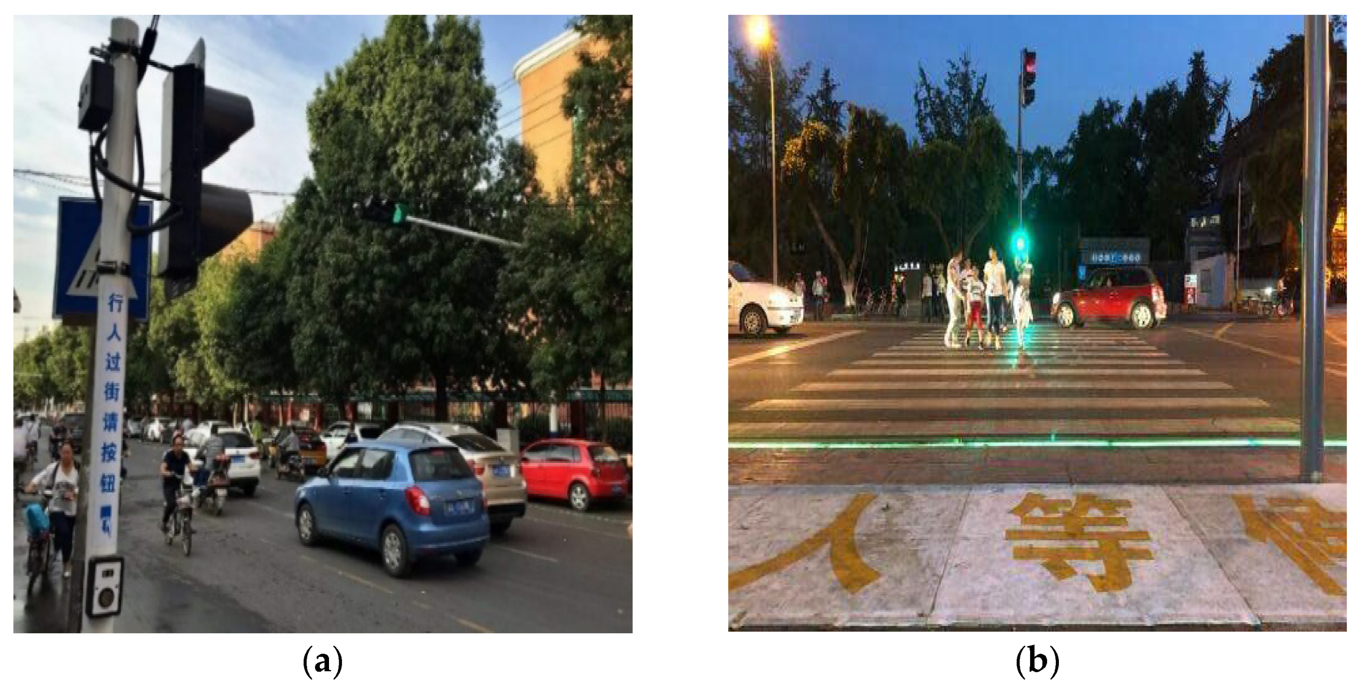
    As shown in Figure 5, the pedestrian crossing traffic light should be set as touch type signal light, and the height of the pedestrian button should be within the range of 1.2 m to 1.5 m. At the same time, set up the sound of traffic lights to remind, the entrance of the crosswalk set up the ground LED light to remind, and kept synchronized with the crossing traffic lights, to prevent “phubs” playing mobile phones to ignore the traffic lights caused by the hidden dangers of crossing the street.
    Figure 5. Pedestrian crossing facilities. (a) Touch type signal lamp. (b) Floor LED reminder lamp.
    Figure 5. Pedestrian crossing facilities. (a) Touch type signal lamp. (b) Floor LED reminder lamp.
    Sustainability 14 06468 g005
    (2)
    Bicycle parking facilities
    Bicycle parking spaces were set up in the space behind the separation zone for motor vehicles and non-motor vehicles and the bus station; a bicycle parking area was planned next to the subway station on the ground to facilitate the transfer between bicycles and subways (as shown in Figure 6).
    Figure 6. Layout of bicycle parking space. (a) Behind the separation zone for motor vehicles and non-motor vehicles and the bus station. (b) Next to the subway station.
    Figure 6. Layout of bicycle parking space. (a) Behind the separation zone for motor vehicles and non-motor vehicles and the bus station. (b) Next to the subway station.
    Sustainability 14 06468 g006
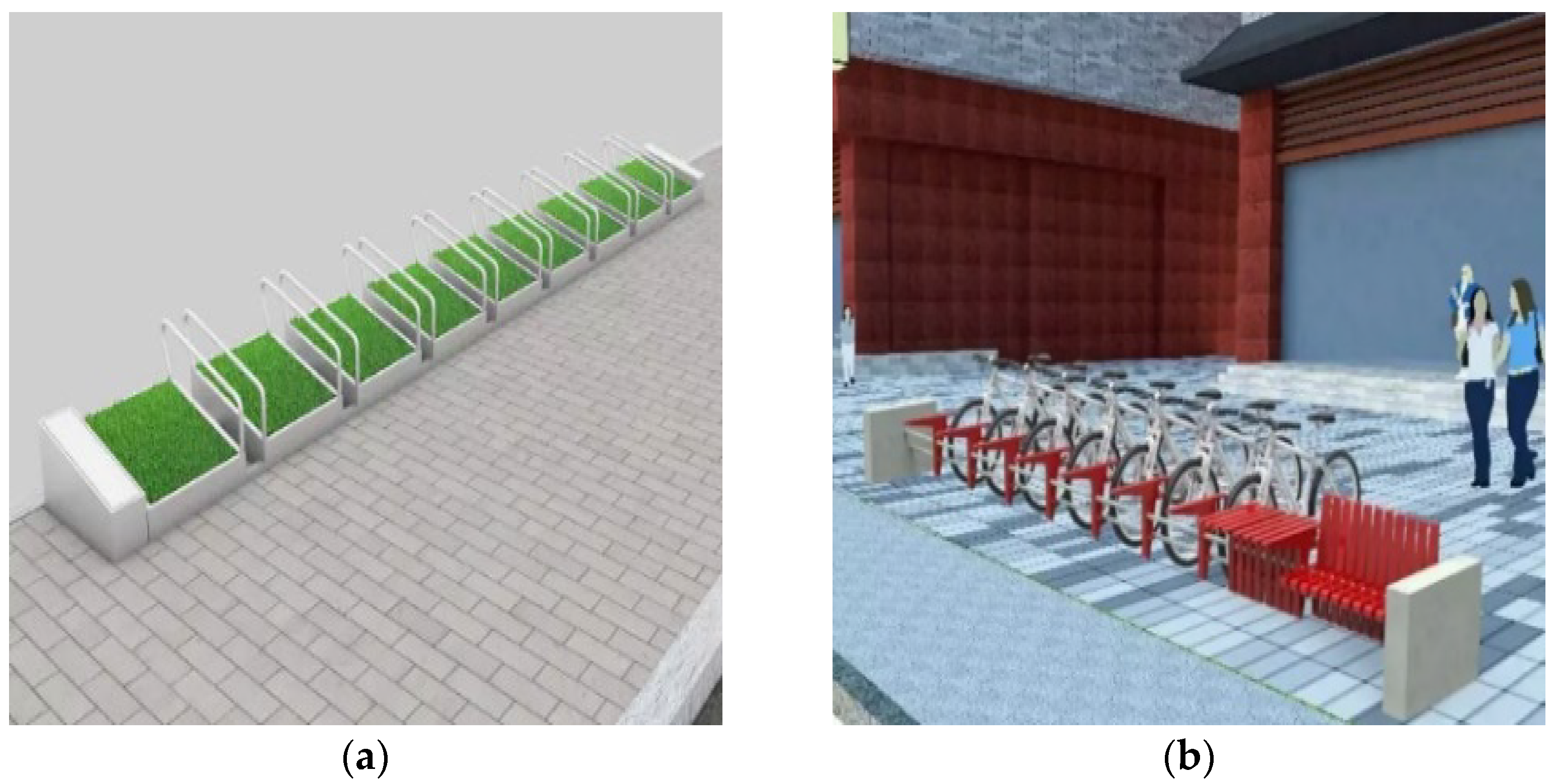
    As shown in Figure 7, bicycle parking facilities could adopt landmark and easily identifiable road parking racks, one for each vehicle, which were easy to park neatly, strong wind resistance and novel.
    Figure 7. Bicycle parking rack. (a) Type one; (b) type two.
    Figure 7. Bicycle parking rack. (a) Type one; (b) type two.
    Sustainability 14 06468 g007
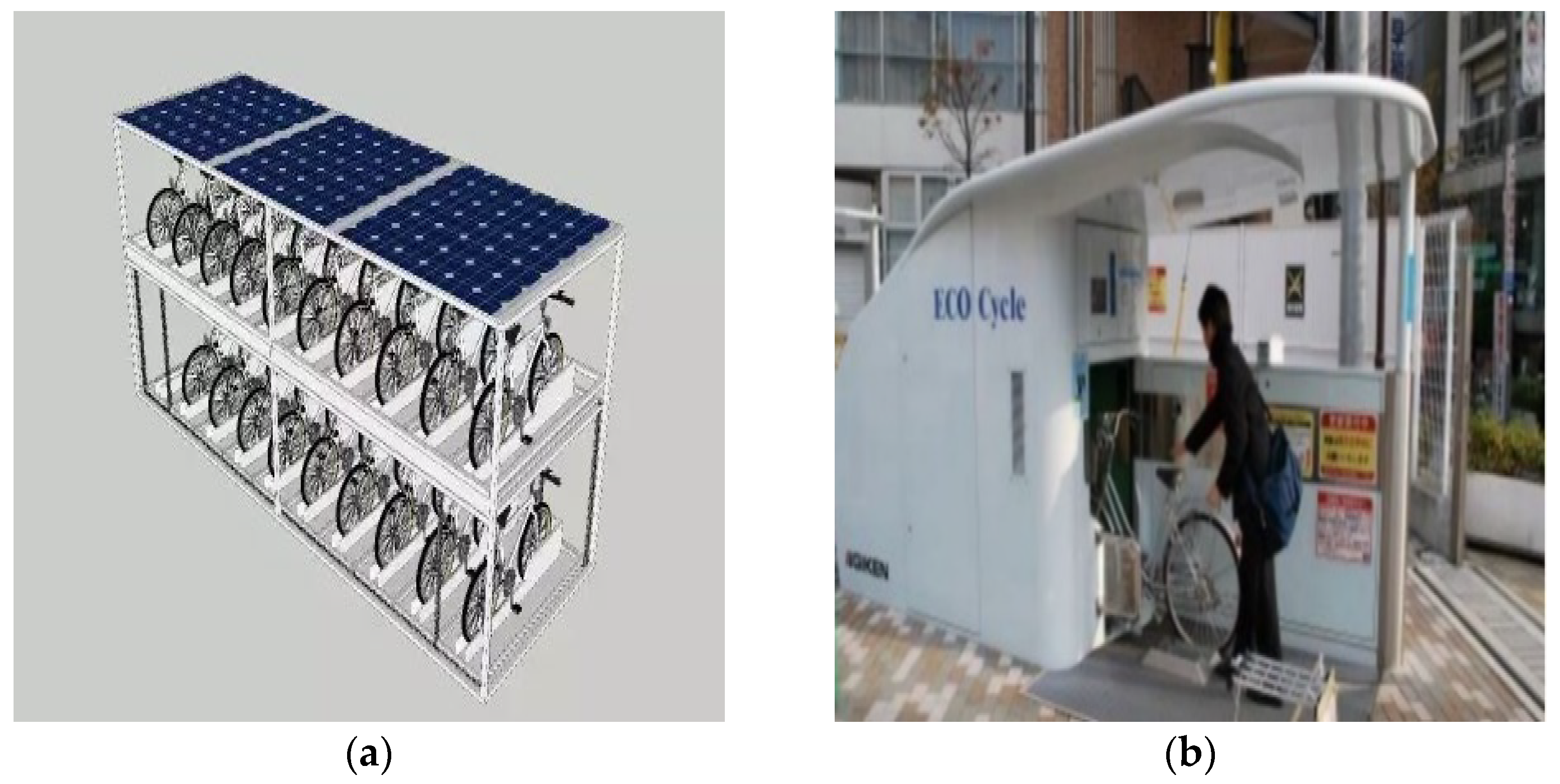
    For nodes with large street space, such as squares and parks, advanced ground and underground three-dimensional bicycle parking methods could be adopted, as shown in Figure 8.
    Figure 8. (a) Underground stereo bicycle parking mode; (b) ground three-dimensional bicycle parking mode.
    Figure 8. (a) Underground stereo bicycle parking mode; (b) ground three-dimensional bicycle parking mode.
    Sustainability 14 06468 g008
    According to the layout characteristics of bicycle parking spaces in vital streets, roadside guardrail parking racks could be used for bicycle parking facilities near the machine non separation belt and subway stations. For bicycle parking facilities in the rear space of the bus shelter, the integrated design of the bus shelter and bicycle facilities could be used, as shown in Figure 9.
    Figure 9. Vital street bicycle parking facilities.
    Figure 9. Vital street bicycle parking facilities.
    Sustainability 14 06468 g009
    (3)
    Motor vehicle parking facilities
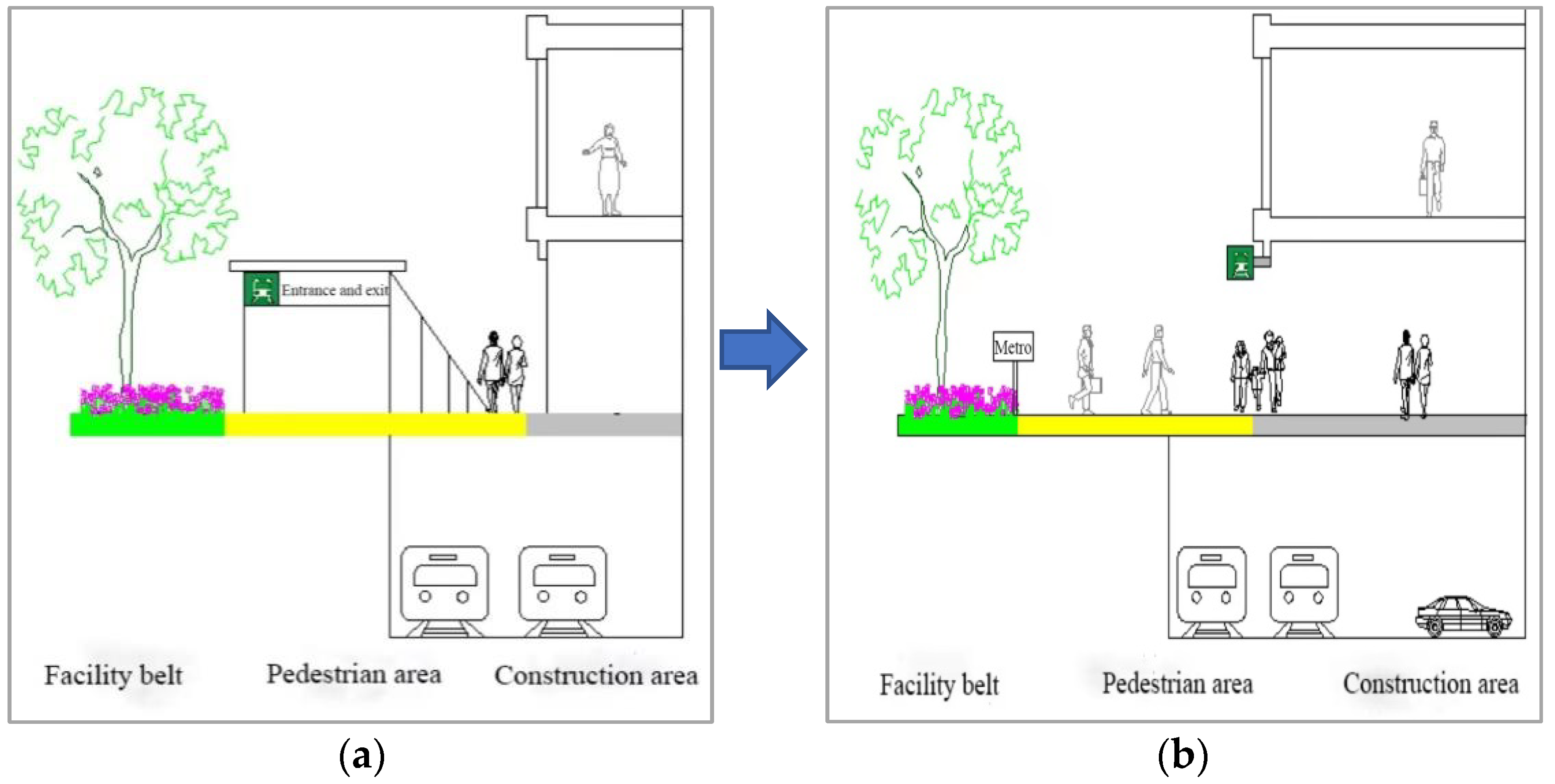
    As shown in Figure 10, make full use of the underground space, set the motor vehicle parking lot in the underground parking lot of large buildings, and set the subway station close to the ground floor of the building to form a “P + R” (parking and transfer) mode with the underground parking lot of the building, so as to facilitate the transfer between motor vehicles and subway.
    Figure 10. (a) Traditional parking facilities; (b) design of motor vehicle parking facilities in a vital street.
    Figure 10. (a) Traditional parking facilities; (b) design of motor vehicle parking facilities in a vital street.
    Sustainability 14 06468 g010
  • Service facilities
    Street service facilities were mainly divided into municipal facilities and public leisure facilities. Municipal facilities mainly included street lights, signs, traffic lights, traffic electronic monitoring and so on; public leisure facilities mainly included leisure seats, cigarette butts dropping devices, mobile phone charging piles, shared charging treasure, etc.
  • Landscape facilities
    In places that affect the driver’s observation line of sight, such as pedestrian crossing, bicycle parking area of facility belt, etc., high trees should be cancelled, and seasonal flowers or green space could be set. In addition, street trees should be pruned regularly to avoid blocking street lights, street signs and signal lights. Add small shrubs in the green belt beside the pedestrian road to create rich levels of high, medium and low, and plant different varieties of street trees for different characteristic sections.

2.1.4. Interface Design of Buildings along the Street

Forming a good and continuous interface in street space was a necessary step to create street vitality. The interface design elements of buildings along the street in the vital street section included architectural space combination and layout, architectural facade form, architectural style, architectural details, etc.
  • Space combination and layout design of buildings
For buildings with prominent volume, in order to avoid visual confusion and damage to the integrity of the space, the closed building on the first floor could be designed as a bench, and the height difference between the building space and the sidewalk could be cancelled, as shown in Figure 11.
2.
Facade form design of buildings
The facade form of the buildings along the vital street should have the characteristics of diversity. For example, there were various types of street buildings in Japan. traditional harmony buildings, ancient shrines or temples were close to modern western buildings. The flexible design process made this diversified facade form let people experience the charm of tradition and modernity at the same time.
3.
Street architectural style design
As shown in Figure 12, streets could form different theme sections according to different architectural styles, which respectively showed the city’s history, cultural relics and historic sites and other cultural and artistic elements, and became the postcards and attractions of the city.
4.
Detailed design of building façade
The details of the design included the building entrance, window, awning, stepping, roof contour, etc. The specific design methods were as follows: transparent glass windows were set at the bottom of the building to reflect the activity information of indoor people to the people on the street so as to attract them. Artistic awning and public telephone facilities were installed in front of the building. The continuous design of the eave line made the roof contour line and the sky as the background form the top interface of the street space.

2.2. Traffic Design of Vital Street Intersection

The design of a vital street intersection included three parts: physical space design, traffic organization design, and ancillary facilities design.

2.2.1. Physical Space Design

Taking the common orthogonal two-way four lane intersection in life as the design object, the traffic design scheme of vital street intersection was formulated. Compared with the traditional street intersection, this scheme had obvious advantages in three aspects: motor vehicle traffic, non-motor vehicle traffic, walking and activity area.
  • Vehicle
The median at the intersection would lengthen the distance and time of pedestrian crossing and aggravate the conflict between people and vehicles. Based on this problem, at the intersection of a vital street, at the place 50 m away from the parking line, the motor vehicle lanes on both sides were compressed to the central separation belt, and the central separation belt became a double yellow line with a width of 50 mm (as shown in Figure 13).
The radius of curb at the intersection of a vital street was designed to be 15 m under the condition that cars, buses, fire vehicles and hospital ambulances could turn right at the speed of 20 km/h [26], and no impact on other lanes.
2.
Non-Motor Vehicle
Continue to pave the colored pavement of non-motor vehicle lanes at intersections and pave the non-motor vehicle crossing passages to maintain the continuity of non- motor vehicle lanes and protective facilities. At the same time, the right-turn lane of non- motor vehicle lane could avoid the interference to the driving of motor vehicles caused by the intersection of large flow of non-motor vehicles at the intersection, and the measures of moving the stop line of non-motor vehicles forward could also be taken (Figure 14).
The code for Urban Road intersection planning GB50647-2011” [26] stipulated that “objects 1 m higher than the pavement elevation and affecting the driver’s line of sight shall not be arranged within the sight distance triangle”, while the triangular pedestrian waiting area of the vital street intersection was within the “sight distance triangle”, so a sunshade with 2.5 m high could be set, which was not only convenient for pedestrians to shade from the sun and rain, but also highlighted the humanized characteristics of the vital street intersection (Figure 15).
3.
Walking and activity area
Continuous leisure seats could be set in the center of the intersection activity area to facilitate the rest of people close to the pedestrian walkway and crossing the street; It could also be combined with squares and parks to form characteristic attraction points. Create a more vital street atmosphere by setting artistic landscape facilities such as landscape plants, fish ponds, and fountains.
In modern cities, mobile vendors could be seen everywhere in urban street space, and the quality of small vendors was also directly related to the image of the city [27]. Therefore, fixed vendor stalls could be set up in the center of the activity area, which could not only solve the problem that the random placement of mobile stalls in the street affecting the appearance of the street, but also provided services for people in street activities.

2.2.2. Traffic Organization Design

Considering that the vitality factor of the vital street mainly came from people, a special phase for pedestrians and non-motor vehicles was designed at the intersection of vital street to protect the safety of pedestrians and non-motor vehicles crossing the street.
Adopted four phase pedestrian non-motor vehicles dedicated phase to guide energy street intersection traffic, according to the phase of the conflict, was widely used for pedestrians and non-motor vehicles traffic flow signal to take “early break” or “late start”, but its root was the loss of pedestrians and non-motor vehicles on the premise of traffic flow time. Therefore, the design study of the intersection of vital street changed it to “late start” and “early break” of motor vehicle signals, in order to protect the right of way for pedestrians and non-motor vehicles.
The code for Urban Road intersection planning” [26] stipulates the tolerance value of pedestrian crossing waiting time at signal control intersections of 80 s. Tongji University conducted a survey on the maximum waiting time of pedestrians crossing the street in Hangzhou. The analysis resulted showed that the waiting time of pedestrians in Hangzhou is about 70–90 s. Considering that pedestrians in the vital street mainly travel flexibly, it could be considered that the maximum endurance time of pedestrians crossing the street at the intersection of vital street was 90 s. In the traditional four phase signalized intersection, pedestrians cross the street with motor vehicle signals. There were four schemes for signal phase shown in Figure 16, Figure 17, Figure 18 and Figure 19.
Among the four phase signal schemes, scheme I and scheme II could be used at intersections with large left-turn traffic flow and special left-turn lanes; some intersections with left-turn lanes could use scheme III. Left-turn traffic flow option 4 could be adopted for smaller intersections without dedicated left-turn lanes. The intersection studied in this study was a common cross-shaped two-way four-lane intersection, and each entrance had a dedicated left-turn lane. Therefore, phase scheme I was selected to study the “early break” and “late start” of motor vehicle signal lights.
For the four phases signal scheme I, the main conflict between vehicles and pedestrians was divided into two stages.
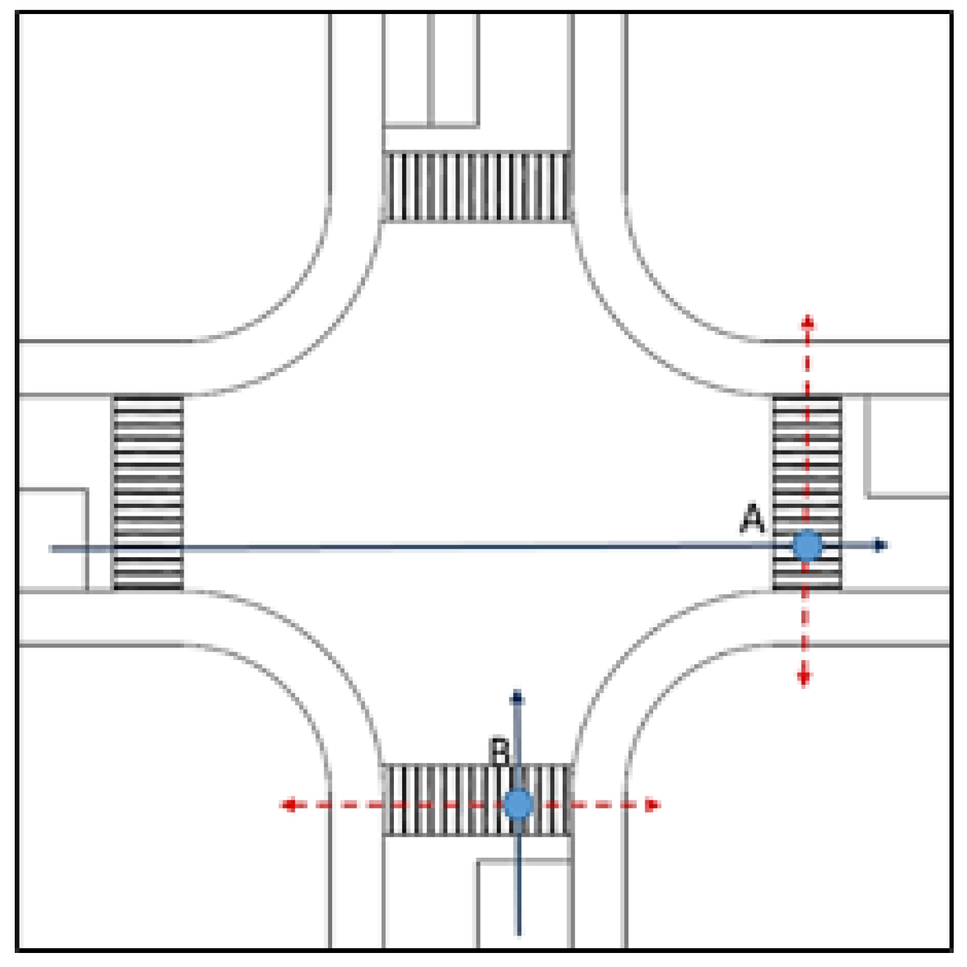
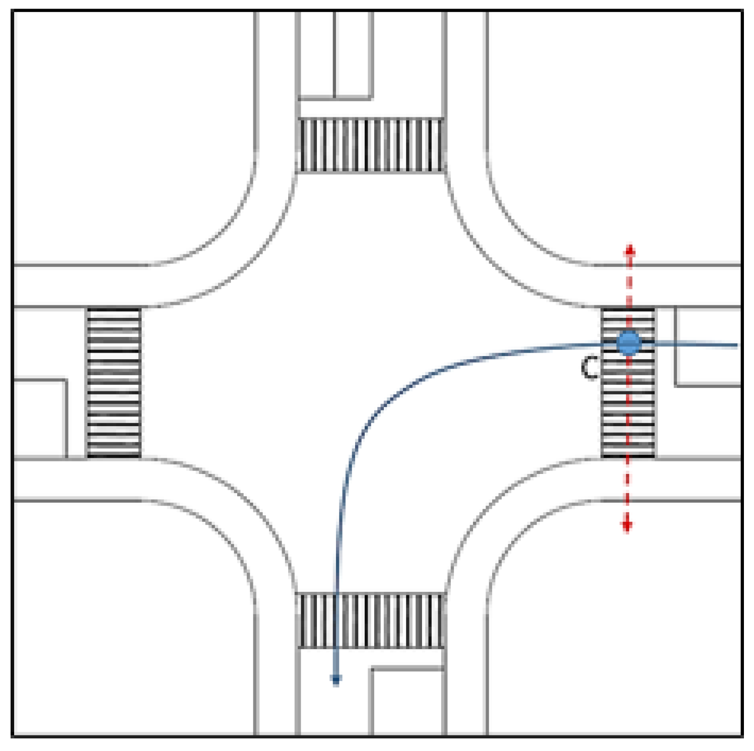
Situation I: when phase 1 was changed to phase 2, there was a conflict between the vehicles going straight at the end of phase 1 green light and the pedestrians crossing the street at the beginning of phase 2 green light. Take one direction for research, and the other direction could get the same conclusion according to the symmetry. Set the conflict point between vehicles departing at the end of phase 1 green light and pedestrians departing at the beginning of phase 2 green light as A. The conflict point between pedestrians departing at the end of phase 1 green light and vehicles departing at the beginning of phase 2 green light was B. The conflict point between non-motor and motor vehicles belonged to the motor vehicle signal control system. This special signal for pedestrians and non-motor vehicles did not consider the impact of the conflict point between non-motor and motor vehicles. The specific conflict point between pedestrians and motor vehicles was shown in Figure 20.
For the most unfavorable conflict point A and conflict point B, the conflict point A could be avoided by making the green light of phase 1 motor vehicle pass “early break”, and the conflict point B could be avoided by making the green light of phase 2 motor vehicle pass “late start”. Where, the time of early motor vehicle interruption at conflict point A must meet the following conditions:
Δ t 1 t a + t Δ t p t n
where, Δ t 1 is the time when the motor vehicle stops early; t a is the time when the straight tail car arrives at the conflict point A; t Δ is the time interval for safe crossing between vehicles and pedestrians, and the value is 1 s. t p is the time for pedestrians to walk from the edge of the road to the conflict point A, taking 1.2 m/s for both people and non-motor vehicles. t n is the reaction time of pedestrian, approximately 0 s. In order to ensure traffic efficiency, we usually take Δ t 1 = Δ t a + t Δ t p t n .
The late rise time of conflict point B shall meet the following conditions:
Δ t 2 t b + t Δ t s t q t 1
where, Δ t 2 is the time when the motor vehicle gets up late; t b is the time from the pedestrian entering the sidewalk from the edge of the road to the conflict point B; t Δ is the interval for safe crossing between vehicles and pedestrians, the value is 1 s. t s is the reaction time when the motor vehicle driver starts the vehicle when the green light turns on, which is 0.5 s; t q is the vehicle start time, set to 1–1.5 s; t 1 is the time from the stop line to the conflict point B, which can be approximated as 1 s. In order to ensure traffic efficiency, we usually take Δ t 2 = Δ t b + t Δ t s t q t 1 .
Situation II: when phase 2 transforms to phase 3, there was conflict between pedestrians crossing the street at the end of phase 2 green light and vehicles turning left at the beginning of phase 3 green light. Take one direction for research, and the same conclusion could be obtained in the other direction according to symmetry. Let the conflict point be C, and the conflict point of C could be avoided by making the green light of phase three vehicles “late start”. Conflict points between pedestrians and motor vehicles were shown in Figure 21.
The conditions for late start time were as follows:
Δ t 3 t c + t Δ t s t q t 2
where, Δ t 3 is the time when the motor vehicle gets up late; t c is the time when the pedestrian enters the sidewalk and reaches the conflict point C at the end of the green light in phase 2; t 2 is the time from the stop line to the conflict point C of the vehicle turning left at the beginning of the green light in phase 3, which can be set to 1 s. In order to ensure traffic efficiency, we usually take Δ t 3 = t c + t Δ t s t q t 2 .
The vital street phase signal control design considering early break and late start is shown in Figure 22.
According to the existing laws and regulations, research results and other aspects of the research and analysis of data, it was suggested that the intersection of vital street for “early break” vehicle signal flashing yellow light, “late start” vehicle signal flashing red light.
For non-motor vehicle crossing traffic organization, non-motor vehicle lane vital street, the crosswalk at the intersection was set up parallel to the sidewalk and set back 5–6 m, as shown in Figure 23.

2.2.3. Ancillary Facilities Design

The design of accessory facilities at the intersection of vital street included three aspects: traffic facilities, service facilities and landscape facilities.
  • Traffic facilities
The traffic signs and lines of a vital street should conform to the standards of Road Traffic Signs and Lines GB 5768.3-2018. The use of color anti-skid paint to draw road marking, paving the road surface and the use of raised structure vibration reflective marking could play a warning role.
The use of three-dimensional crosswalks or color crosswalks in crosswalks at intersections, as shown in Figure 24, could give pedestrians and motor vehicle drivers a strong visual stimulation, thus enhancing the traffic warning of crosswalks.
2.
Service facilities
The modeling characteristics and color style of street service facilities should be coordinated with the section environment. In turning public spaces at intersections, seats should not be too close to footpaths; Public seats with artistic shapes could also be used to serve people and become street pieces, as shown in Figure 25.
There were some small facilities such as flower beds, steps, etc, which could increase the interest of walking space landscape. According to relevant specifications and aesthetic requirements, the height of street public leisure seats should be controlled at about 500 mm, and environmentally friendly intelligent garbage cans, lighting street lamps, and WiFi signals should be arranged around the seats.
3.
Landscape facilities
In terms of architecture, the buildings in the intersection corner space were laid out hierarchically or arranged in parallel to create a visual effect with a sense of enclosure, and the shape and style were unified with the section and coordinated with the surrounding environment. In the aspect of street landscape, it created street sketches that were representative of street culture, and attracted more people with appearance modeling, artistic features, colors, and materials.

3. The Empirical Analysis

3.1. The Empirical Selection

3.1.1. The Empirical Generalizations

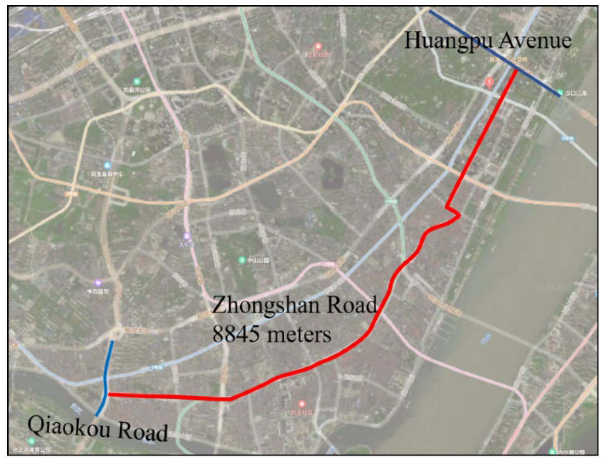
Wuhan Zhongshan Avenue is the most important commercial traffic trunk road in Old Hankou. As shown in Figure 26, it was 8445 m long and ran from southwest to northeast, intersecting with 48 streets in the middle, such as Wusheng Road, Youyi Road, Jianghan Road, Dazhi Road, Shengli Street and Sanyang Road.

3.1.2. The Empirical Generalizations

With the rapid development of Wuhan’s commercial economy, although the commercial form along Zhongshan Avenue was very large, conflicts between people and cars could be seen everywhere on the street, disorderly placement of advertisements hinders the sidewalk, and shop signs block the facade of buildings. All of these phenomena were not in harmony with their historical features.
In order to comprehensively improve the commercial atmosphere, environmental quality and landscape image of Zhongshan Avenue, Wuhan municipal committee and government has carried out upgrading and reconstruction of Zhongshan Avenue under the concept of “Life is better because of the street”. In this transformation, the traffic function positioning changed from “car-oriented” to “people-oriented”, emphasizing “slow traffic + bus”, creating a very representative of the cultural heritage of Wuhan slow commercial block.
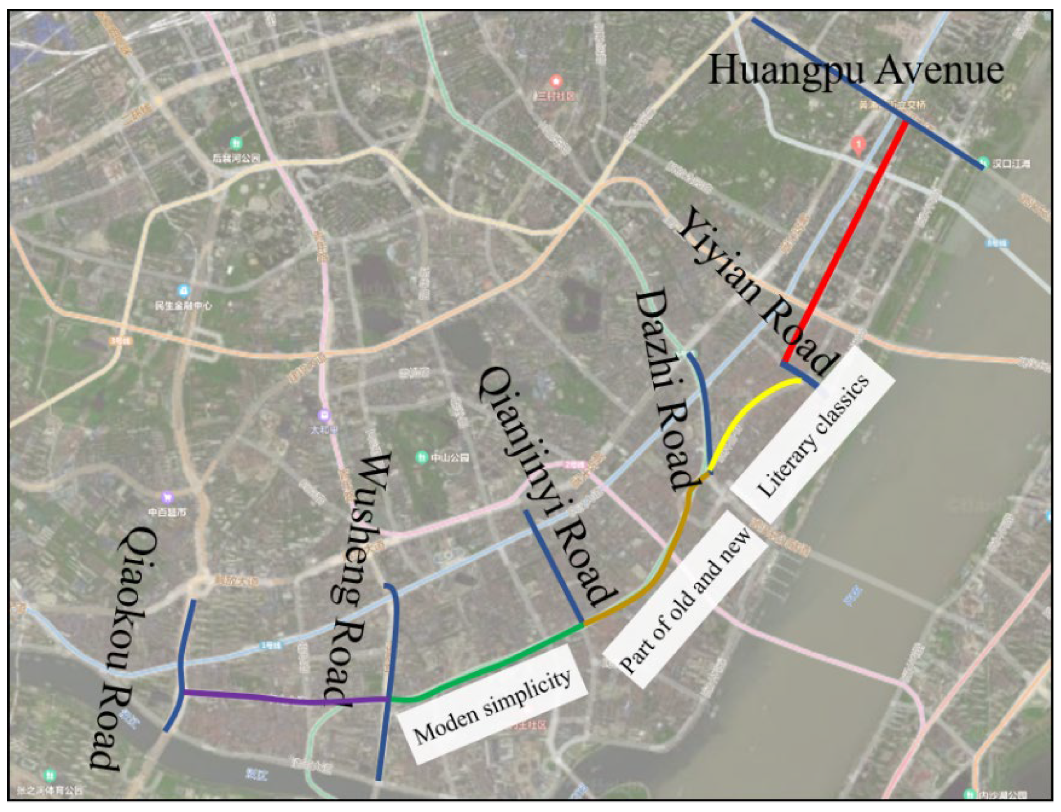
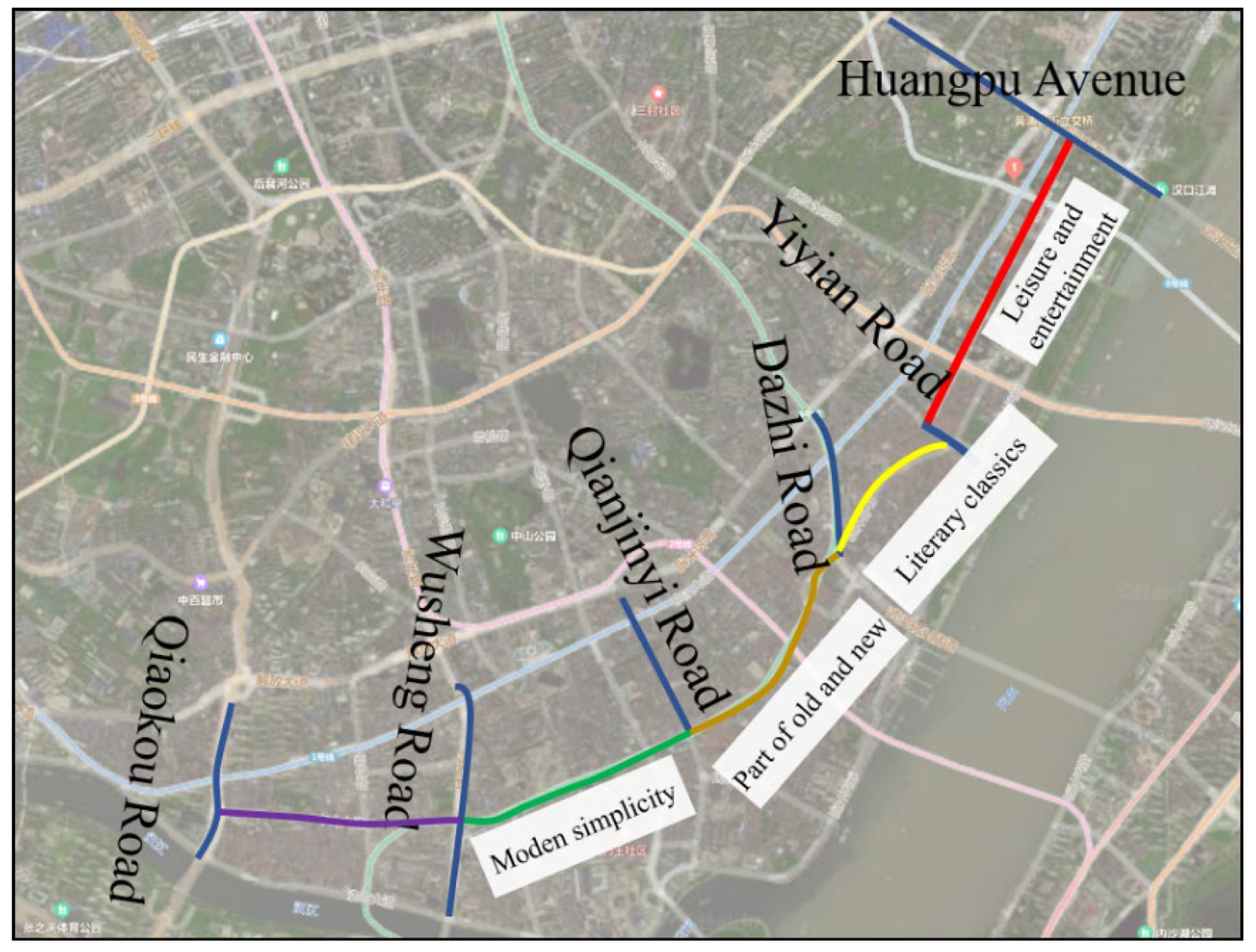
As shown in Figure 27, the reconstruction project of Zhongshan Avenue started from Wusheng Road in the west and ended at Yiyuan Road in the east, with a total length of 4.8 km and two to eight lanes in both directions. According to the architectural features along the line, the whole line was divided into three sections. The western section (Wusheng Road-Qianjin Road) was the modern simple section, the middle section (Qianjin Road-Dazhi Road) was the blend of old and new, and the eastern section (Dazhi Road-Yiyuan Road) was the classical art section.

3.1.3. Traffic Development of Zhongshan Avenue in Wuhan City

  • Motor traffic system
After the reconstruction of Zhongshan Avenue, Huangshi Road-Qianjin Road only allowed public transportation, the traffic flow on the road was significantly reduced, and the traffic efficiency was significantly improved. The average speed was increased from 15 km/h before the reconstruction to 29 km/h now, and the speed was nearly doubled. The traffic operation status was changed from serious congestion level before the reconstruction to basically smooth level. Due to the impact of car restrictions on some sections of Zhongshan Avenue, the car accessibility in the business circle along Zhongshan Avenue decreased, and the bypass distance of transit vehicles increased by about 1.2 km, while the bypass distance of arriving vehicles in the business circle of Jianghan Road increased by about 0.7 km.
2.
Rail transit system
The card swiping data of passenger flow showed that 44% and 43% of the regional subway passengers were from Wuchang and Hankou, respectively, and the attraction to the long-distance travel areas such as East Lake high-tech zone and Hanyang district reached 7.9% and 11%, respectively, indicating that the regional rail transit had undertaken medium and long-distance travel, which was in line with the positioning of rail transit.
3.
Conventional bus system
The average daily arrival intensity of regular buses in Zhongshan Avenue increased from 633 times before construction to 846 times after reconstruction, and the average waiting time of stations decreased by 33.6%. However, Jianghan Road station of Zhongshan Avenue is greatly affected by the reduction of lines, with an average of 1481 arrival times, 55.4% less than 3320 times before construction. The passenger flow of each station in the region decreased from 253,000 to 243,000, a decrease of 4%. Before the reconstruction, the average daily passenger flow of Jianghan Road station on Zhongshan Avenue was 32,000; after the reconstruction it was reduced to 9200. The bus passenger flow mainly shifted to rail transit and adjacent roads, among which Jianghan No.2 Road and Jianghan No.4 Road had a net increase of 13,800 conventional bus passengers per day.
4.
Bicycle system
After the reconstruction of Zhongshan Avenue, the proportion of bicycle travel increased to a certain extent. Under the influence of multiple factors such as the sectional rectification of Zhongshan Avenue and the development of shared bikes, the proportion of regional bicycle and electric bike use increased to a certain extent. There were about 2000 shared bikes in the region, and the daily rides (including electric bikes) in the business district of Jianghan Road were about 15,000, accounting for more than 8% of the regional passenger flow, which had become a large travel group.
5.
Walking system
After the reconstruction of Zhongshan Avenue, the slow travel environment, especially the walking environment, had been significantly improved. According to statistics, Jianghan Road business district attracted about 176,000 passengers a day, 23,000 more than 153,000 before the transformation, an increase of about 15%.

3.2. Traffic Characteristics Analysis of Zhongshan Avenue in Wuhan City

3.2.1. Research Contents and Methods

Through the traditional questionnaire survey as shown in the Appendix A, it summarized and analyzed the current traffic characteristics and existing problems of Zhongshan Avenue, provided design strategies for the reconstruction, and practiced the design process of “investigation-analysis-design”.
The research time was selected on 23 and 24 April 2021. The weather was sunny and suitable for activities. A total of 800 questionnaires were distributed, and 791 valid questionnaires were collected, including 328 on weekdays and 463 on weekends.
The questionnaire was divided into two parts. The first part was the basic information of the respondents, including the age, gender, and travel purpose of the traffic users of Zhongshan Avenue, through which the composition of the main activity objects of Zhongshan Avenue could be understood. The second part was the investigation of the traffic characteristics of Zhongshan Avenue. By investigating the types of vehicles used by travelers, the time, times, feelings of use, and suggestions for traffic improvement, we could understand travelers’ actual traffic needs and existing problems on Zhongshan Avenue.

3.2.2. Survey Statistics and Traffic Characteristics Analysis

The age structure of respondents is shown in Figure 28. It can be seen from the figure that on weekdays and weekends, the activities of Zhongshan Road were mainly for young and middle-aged crowd, with relatively few children and the elderly. The lack of recreational facilities or other related elements that children are interested in on the streets also reflects, to a certain extent, that Zhongshan Road has neglected to consider special groups such as the elderly and children.
Table 1 shows the survey results of pedestrian travel purpose on weekdays and weekends. Through the field behavior observation and investigation and interview, it was shown that Zhongshan Avenue, as a living street, not only provided people with a variety of means of transportation, but also provided nearby residents with a place for pedestrian activities and communication. At the same time, as a historical protection and tourism block, it also provided foreign tourists with leisure places for sightseeing and rich shopping, catering and entertainment activities, so Zhongshan Avenue was more attractive to people, and the street showed a vital state.
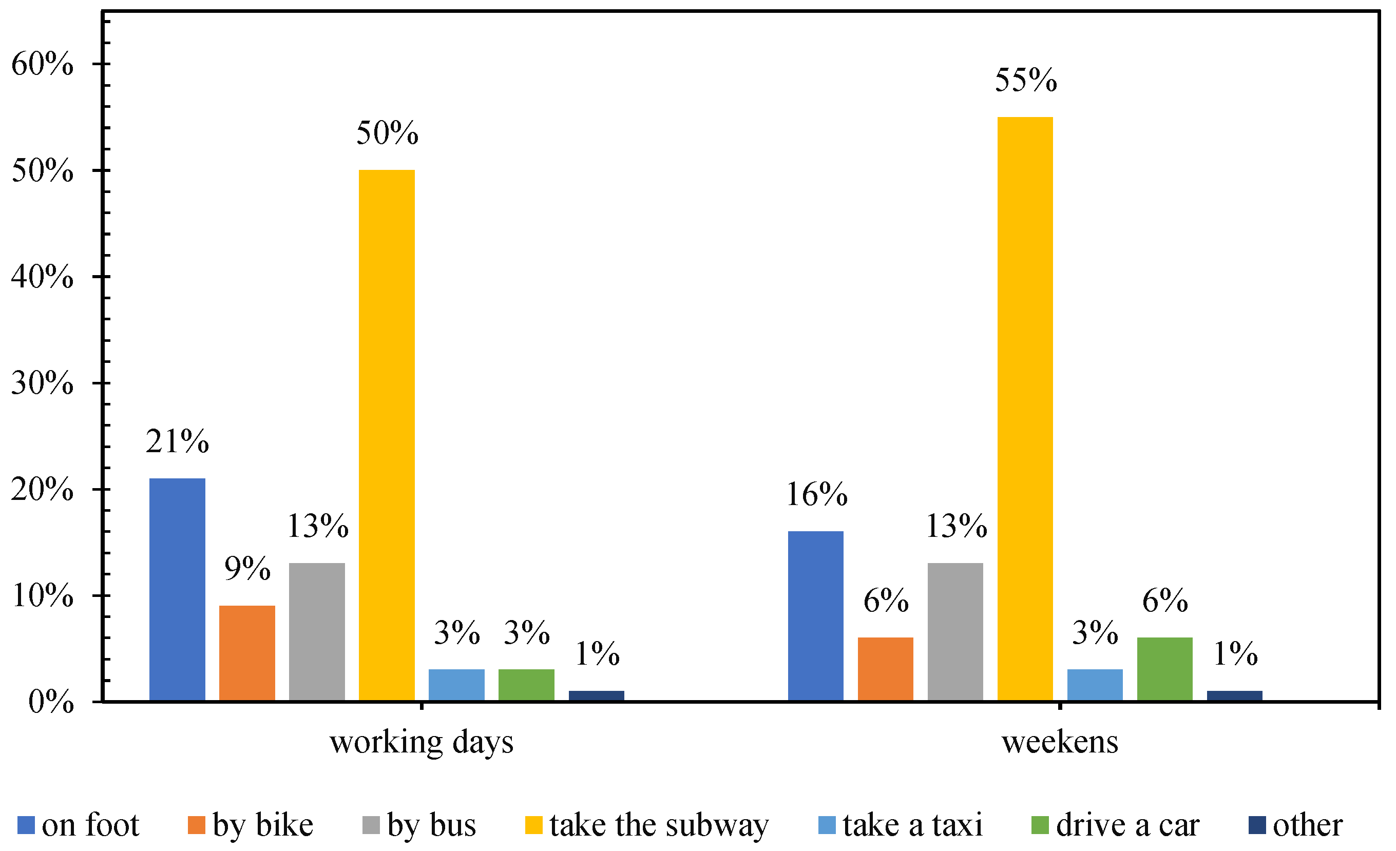
Among the means of transportation that people used to get to Zhongshan Avenue on weekdays and weekends, the utilization rate of subway accounts for 51%, followed by walking and bus, bicycle accounted for less, and car travel was even less. When people leaved Zhongshan Avenue on weekdays and weekends, the use rate of subway was still the first, followed by walking, bus and bicycle, and the proportion of car travel was still very low. Figure 29 and Figure 30 showed the statistics of the choice of traffic modes for pedestrians arriving and leaving Zhongshan Avenue. It could be seen that the proportion of people arriving or leaving Zhongshan Avenue by public transport was high, followed by slow traffic. 87% of people surveyed the crowd bus and subway more convenient to choose public transportation, 90% of people looked at the pedestrian environment showed more satisfied, so the Zhongshan Road of “priority to public transport was given priority to go slow” traffic idea became the protecting environment, promoted the vigor of Zhongshan Road street main factors. The proportion of car trips is relatively low, which is related to the traffic management measures of Zhongshan Road prohibiting motor vehicles from entering at different times. More than 60% of the respondents who choose to drive by themselves think that it is inconvenient to enter Zhongshan Road by car. The main reason for the lack of parking spaces on Zhongshan Road is that it takes time to find a parking space, and it is inconvenient to enter and exit the parking lot. This is also the main reason why more people choose public transportation and slow travel.
From the perspective of people’s attitude towards the cycling environment of Zhongshan Avenue, more than half of the respondents thought the cycling environment of Zhongshan Avenue was good. In order to understand people’s suggestions on improving the cycling environment of Zhongshan Avenue, the questionnaire put forward four hypotheses: setting up non-motor vehicle lanes, adding public bicycle spots, setting up bicycle parking spots and others. It could be concluded from the statistical data shown in Table 2: The proportion of suggestions for setting up non-motorized lanes was the highest, followed by setting up bicycle parking places and adding public bicycle spots. It could be shown that the environment of Zhongshan Avenue was good, and people showed their willingness to use bicycle transportation. Therefore, there was a large demand for bicycle transportation in Zhongshan Avenue, and cycling conditions needed to be further improved.
In terms of people’s satisfaction with the rebuilt Zhongshan Avenue, 90% of the respondents thought that the rebuilt Zhongshan Avenue was better than before, and 60% of them thought that the main reason was that buses and subways were more convenient. Through analysis, it was found that many people hope that Zhongshan Avenue could add non-motorized lanes, set up street greening, leisure facilities and bicycle parking areas, and strengthen management.
Based on the data from the above questionnaire, 57% of the total population were aged 21 to 40, which showed that the traffic participants are mainly young people who prefer leisure and entertainment, and the proportion of shopping, dining and entertainment was as high as 69%. At the same time, young people are willing to accept new things, and they agree with the vital street design concept. Most of them are willing to choose to public transportation, with the proportion reaching 51%. It can be seen that there was a close correlation between the factors of the questionnaire. The four major green transportation modes of bus, subway, bicycle, and walking have become the main means of transportation for people to reach and leave Zhongshan Avenue, which has a huge impact on the improvement of the vitality of Zhongshan Avenue. The economic and environmental benefits it brings are obvious, making the renovated Zhongshan Avenue a vibrant living street. Therefore, combined with the problems and suggestions reflected in the questionnaire survey, the traffic design method of Zhongshan Avenue by adopting the method of vital street has a positive effect on enhancing the vitality of Zhongshan Avenue.

3.3. Traffic Design of Zhongshan Avenue in Wuhan City

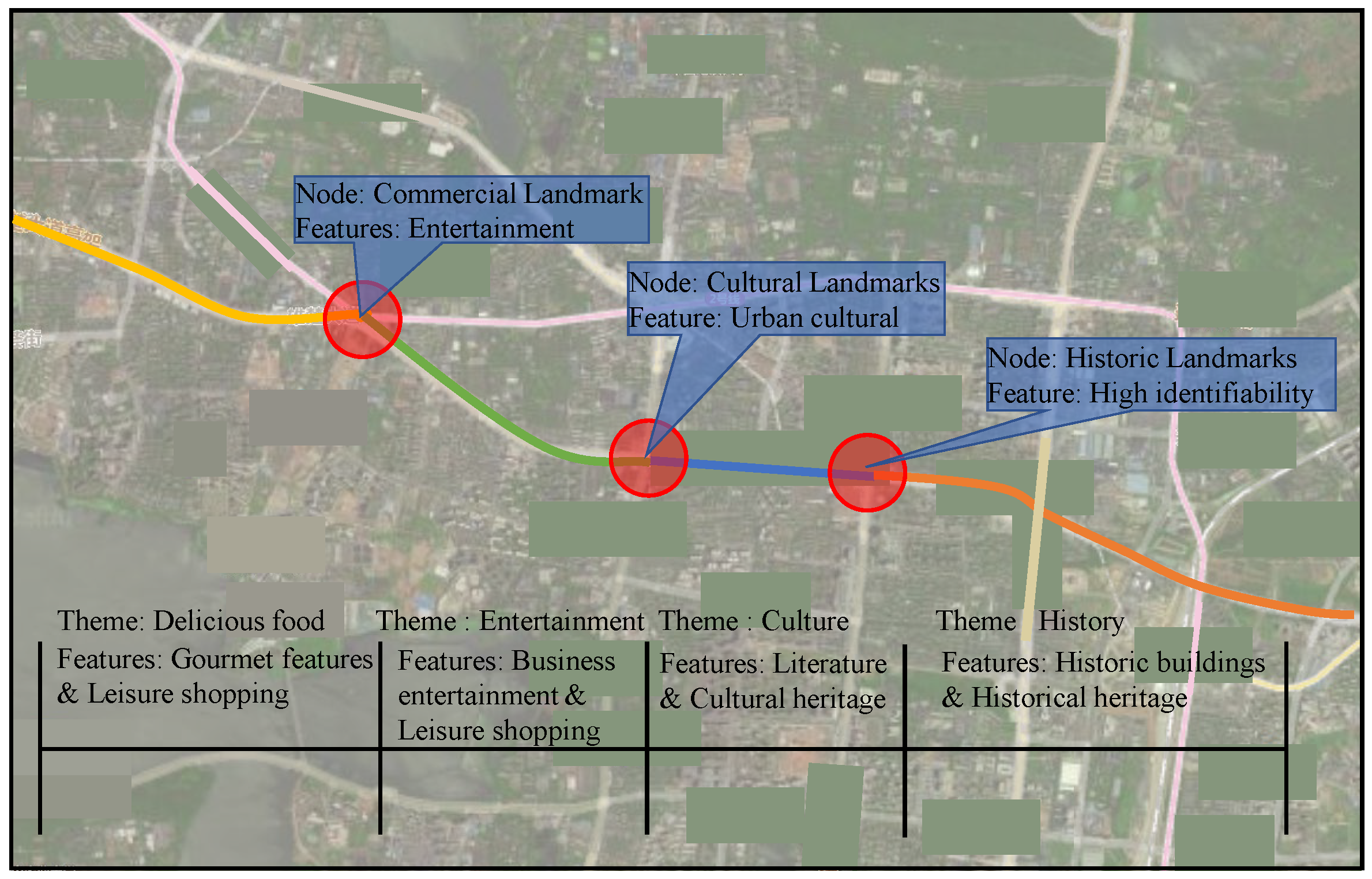
Zhongshan Avenue is located in the center of Wuhan city. There were abundant commercial shops on both sides of the street and a large flow of people. After two years of reconstruction, as shown in Figure 31, it was divided into three sections with distinctive themes according to the characteristics of buildings along the road. Therefore, in view of problems and suggestions reflected in the questionnaire survey of Zhongshan Avenue, the east section of Zhongshan Avenue (Yiyuan Road, Huangpu Avenue) was designed for a vibrant street traffic, and was set as a entertainment section according to the commercial characteristics and architectural style. It was connected with the other three sections to form a specific representative vital street in Wuhan.
Based on the field survey of the building structures around the east section of Zhongshan Avenue (Yiyuan Road-Huangpu Street), it was known that there were a lot of commercial buildings, residential buildings, hospitals, schools and parks around the east section of Zhongshan Avenue. People had a great demand for leisure and wandering life. Therefore, the key point of east Zhongshan Road (Yiyuan Road, Huangpu Street) road traffic design was to change the original large-scale space for motor vehicles and protect the lanes of non-motor vehicles and pedestrians, which could create a good slow-moving environment for residents, and provide users with a more comfortable and convenient walking experience while ensuring street safety.
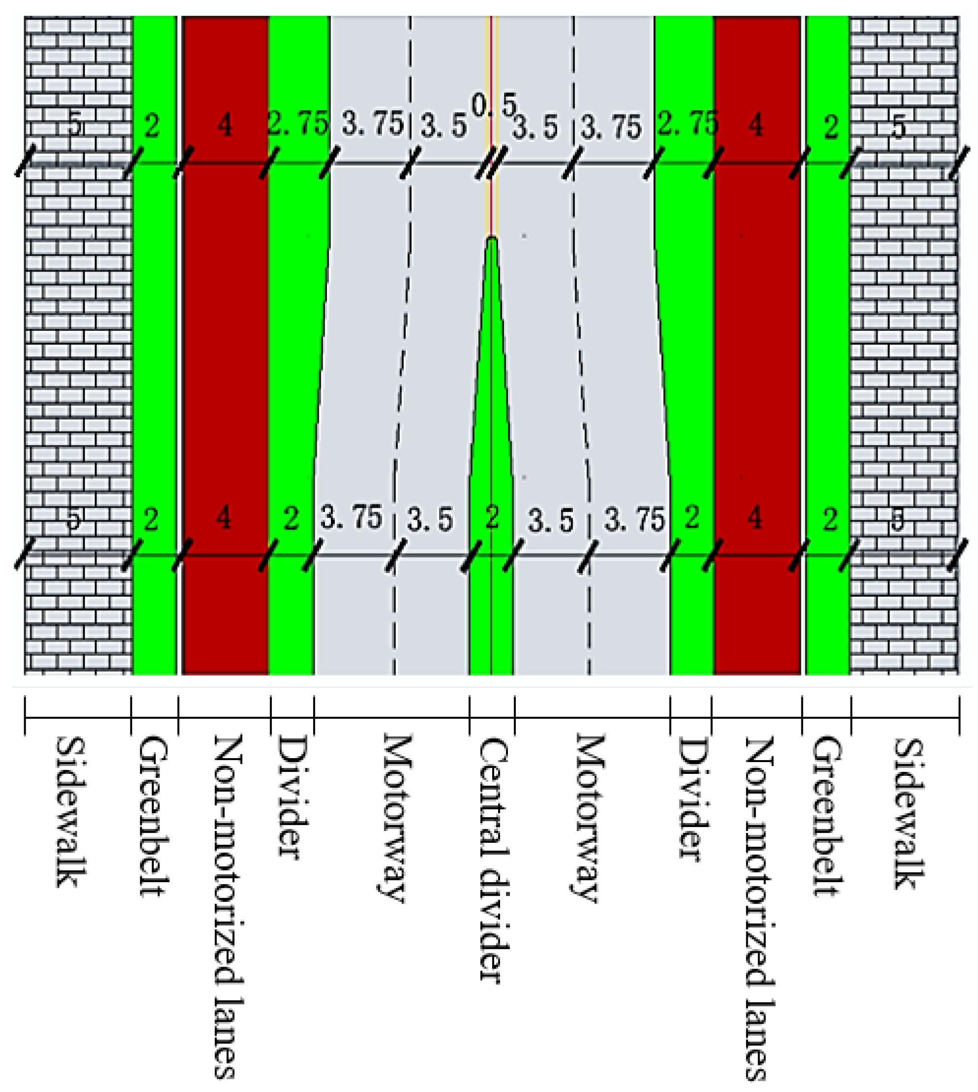
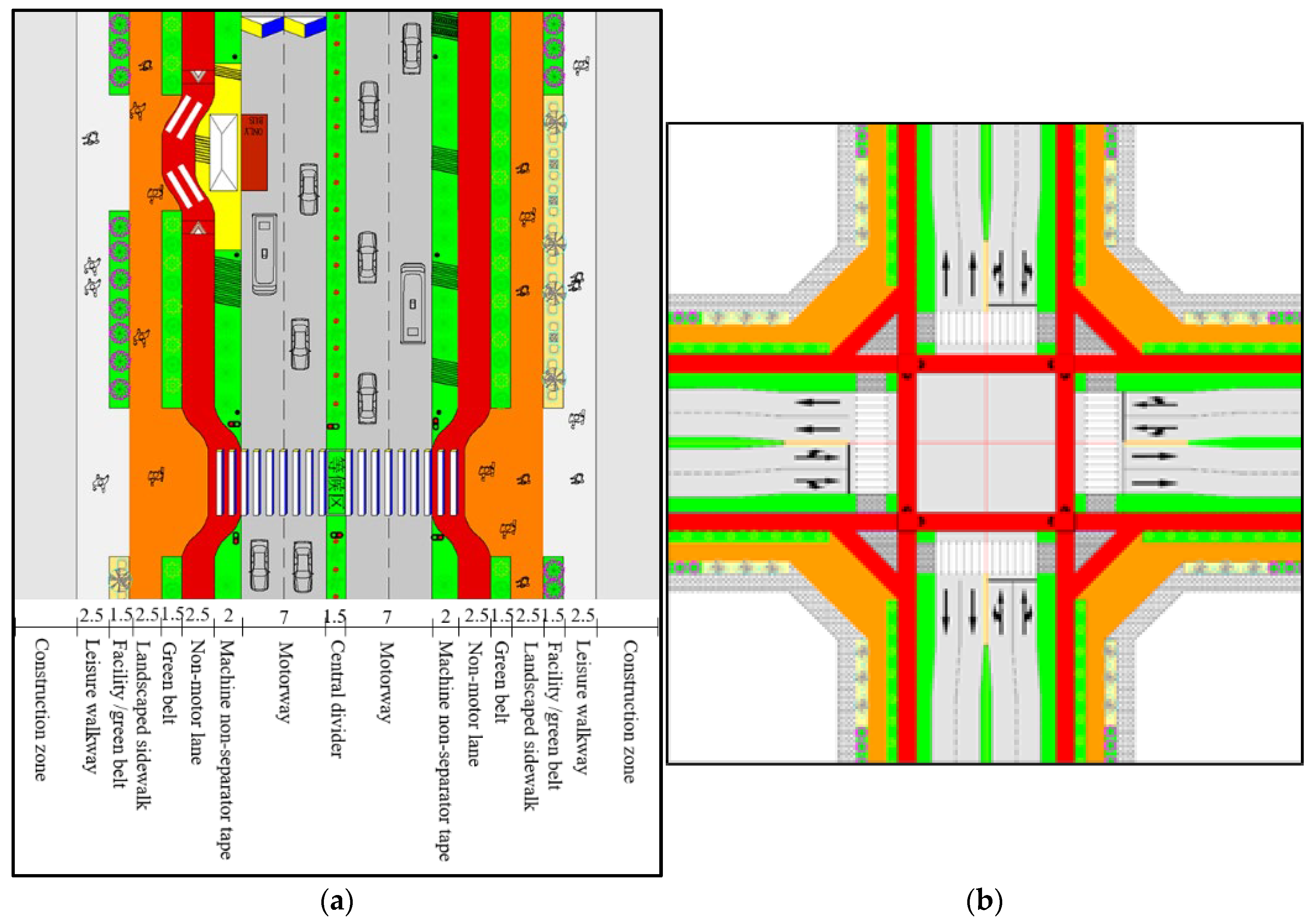
The red line of the east section of Zhongshan Avenue (Yiyuan Road-Huangpu Street) was 40 m wide, and the design speed was 40 km/h. The standard cross section was shown in Figure 32 below, in which non-motor vehicles were on the same plane as the pavement.
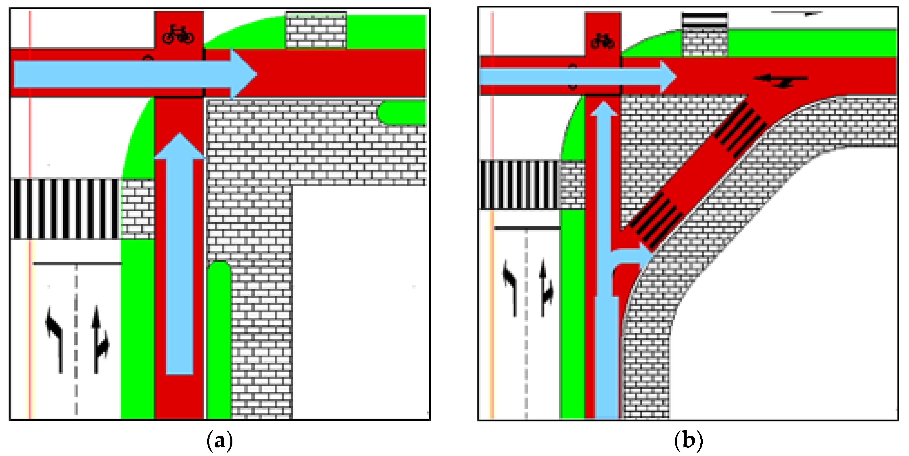
The key point of east Zhongshan Avenue (Yiyuan Road-Huangpu Street) intersection traffic design (as shown in Figure 33) was to control the speed of motor vehicles entering the intersection and turning, so as to ensure the safety of cyclists and pedestrians crossing the street. Extending the protection measures for non-motor vehicles and pedestrians on the road section, and rationally designing the traffic organization at the intersection, can make each traffic flow orderly.

4. Conclusions

Based on the perspective of street users, this paper studied the traffic of urban vital streets, studied the traffic design methods of sections and intersections of vital streets, and selected Zhongshan Avenue in Wuhan city as the object of an empirical analysis for traffic design research. The following conclusions were drawn:
  • The basic idea of a vital street is being “people-oriented”. We concluded that the traffic connotations for a vital street lie in having an efficient, safe, healthy, and environment-friendly green traffic system and a good slow travel environment.
  • The traffic design method for a vital street section was determined. According to the main characteristics of vital streets, combined with the design concept of being “people-oriented”, four aspects of design elements and specific design methods were discussed: road interior space, walking and activity space, auxiliary facilities, and street architectural interface.
  • The traffic design method of the intersections of vital streets was determined, mainly from consideration of three parts of the key points and methods of design: physical space design, traffic organization design, and auxiliary facilities design
This study conducted research on a relatively wide street section and a conventional intersection, and achieved some research results. On this basis, the pedestrian path design of a narrow street section and a vital street traffic design of a deformed intersection was further carried out. However, this study was focused on the phase-signal scheme of the intersection; further analysis and research needs to be carried out for signal timing optimization.

Author Contributions

Conceptualization, F.W. and M.L.; methodology, H.W.; validation, D.G.; formal analysis, C.T. and M.L.; investigation, C.T. and D.G.; data curation, C.T.; writing—original draft preparation, F.W. and C.T.; writing—review and editing, D.G. and H.W.; visualization, F.W. and D.G.; project administration, F.W. and H.W. All authors have read and agreed to the published version of the manuscript.

Funding

This research received no external funding.

Informed Consent Statement

Informed consent was obtained from all subjects involved in the study.

Data Availability Statement

If necessary, you can obtain study-related data from the corresponding author.

Conflicts of Interest

The authors declare no conflict of interest.

Appendix A

Evaluation form of Regional Reconstruction of Zhongshan Avenue, Wuhan city
Dear citizens,
Hello! This questionnaire is made to evaluate the regional reconstruction of Zhongshan Avenue in Wuhan city. Thank you for taking your precious time to fill in this questionnaire, which will take about 5 to 8 min of your time. Your support is an encouragement to our work, thank you!
1. What’s your gender?
○Male ○Female
2. What’s your age?
○Younger than 20 years old ○21–30 years old ○31–40 years old
○41–50 years old ○51–60 years old ○Over 60 years old
3. What is the main purpose of your arrival in the Zhongshan Avenue area?
○Commuting ○Entertainment ○Visiting relatives and friends
4. Which means of transportation will you take to reach the Zhongshan Avenue area
○A. Walking ○B. Bicycle ○C. Bus ○D. Subway
○E. Taxi ○F. Driving ○G. Others
5. Is it convenient for you to travel by subway or bus?
○A. Convenient ○B. Inconvenient
If you find it inconvenient, because___________?
○A. Fewer lines ○B. Too long interval ○C. Heavy traffic ○D. Others
How long do you walk after getting off the subway or bus?
○A. Less than 5 min ○B. 5–10 min
○C.10–20 min ○D. More than 20 min
6. What do you think of the walking environment?
○A. Very good ○B. Fine ○C. Not good ○D. Bad
7. If you choose bicycle (electric bike), what do you think of the riding environment?
○A. Very good ○B. Fine ○C. Not good ○D. Bad
What do you think needs to be improved?
○A. Set up non-motor vehicle lanes ○B. Add public bicycle spots
○C. Set bicycle parking positions ○D. Others
8. If you choose to drive, do you find it convenient to park?
○A. Convenient ○ B. Inconvenient
If you find it inconvenient, because__________________?
○A. It takes time to find a parking space
○B. Access to the parking lot is not convenient
○C. Not enough parking space
○D. Others
How long does it take you to park?
○A. Less than 5 min ○B. 5–10 min
○C. 10–20 min ○D. More than 20 min
How much do you usually pay for parking?
○A. Less than 10 yuan ○B. 11–20 yuan ○C. 21–30 yuan ○D. More than 30 yuan
9. Which means of transportation will you take to leave the Zhongshan Avenue area?
○A. Walking ○B. Bicycle ○C. Bus ○D. Subway
○E. Taxi ○F. Driving ○G. Other
10. Do you often travel at ____________________ (multiple choices)?
○A. before 5:00 ○B. 5:00–7:00 ○C. 7:00–9:00 ○D. 9:00–11:00
○E. 11:00–17:00 ○F. 17:00–19:00 ○G. 19:00–21:00 ○H. 21:00 after
11. How often do you get to the Zhongshan Avenue area?
○A. Daily ○B. Twice or three times A week
○C. Once a week ○D. Once a month ○E. Other
12. Do you think there is any difference before and after the reconstruction of Zhongshan Avenue?
○A. Yes ○B. No
If there is any difference, do you think the reconstruction of Zhongshan Avenue has become better or worse?
○A. Getting better ○B. Getting worse
If there is a difference, do you think it is due to traffic?
○A. Yes ○B. No
How did you get to Zhongshan Avenue before? Is it the same as now?
○A. Same as ○B. Different
If not, which mode of transportation did you use before?
○A. Walking ○B. Bicycle ○C. Bus ○D. Subway
○E. Taxi ○F. Driving ○G. Other
What is the reason for you to change the way you travel?
○A. Convenient bus/subway transportation
○B. Inconvenient bus/subway transportation
○C. Driving is convenient
○D. Inconvenient to drive
○E. Others
13. What traffic improvement suggestions do you have for the Zhongshan Avenue area?

References

  1. Zhou, X.; Rana, M.P. Social benefits of urban green space: A conceptual framework of valuation and accessibility measurements. Manag. Environ. Qual. 2012, 23, 173–189. [Google Scholar] [CrossRef]
  2. Hegetschweiler, K.T.; Vries, S.D.; Arnberger, A.; Bell, S.; Brennan, M.; Siter, N.; Olafsson, A.S.; Voigt, A.; Hunziker, M. Linking demand and supply factors in identifying cultural ecosystem services of urban green infrastructures: A review of European studies. Urban For. Urban Green. 2017, 21, 48–59. [Google Scholar] [CrossRef] [Green Version]
  3. Rodriguez-Valencia, A.; Ortiz-Ramirez, H.A. Understanding Green Street Design: Evidence from Three Cases in the U.S. Sustainability 2021, 13, 1916. [Google Scholar] [CrossRef]
  4. Ravenscroft, N. The Vitality and Viability of Town Centres. Urban Stud. 2015, 37, 2533–2549. [Google Scholar] [CrossRef]
  5. Qi, Y.; Chodron Drolma, S.; Zhang, X.; Liang, J.; Jiang, H.; Xu, J.; Ni, T. An investigation of the visual features of urban street vitality using a convolutional neural network. Geo-Spat. Inf. Sci. 2020, 23, 341–351. [Google Scholar] [CrossRef]
  6. Gehl, J. Life Between Buildings: Using Public Space; Island Press: Washington, DC, USA, 1987. [Google Scholar]
  7. Montgomery, C. Happy City: Transforming Our Lives through Urban Design. Civ. Eng. 2014, 84, 74. [Google Scholar]
  8. Jacobs, J. The Death and Life of Great American Cities; Vintage Books: New York, NY, USA, 2012. [Google Scholar]
  9. Cranshaw, J.; Schwartz, R.; Hong, J.I.; Sadeh, N. The Livehoods Project: Utilizing Social Media to Understand the Dynamics of a City. Soc. Sci. Electron. Publ. 2012, 6, 58–65. [Google Scholar]
  10. Feick, R.; Robertson, C. A multi-scale approach to exploring urban places in geotagged photographs. Comput. Environ. Urban Syst. 2015, 53, 96–109. [Google Scholar] [CrossRef]
  11. Harvey, C.W. Measuring Streetscape Design for Livability Using Spatial Data and Methods; The University of Vermont and State Agricultural College: Burlington, VT, USA, 2014. [Google Scholar]
  12. Bell, S. Imagining the Future City: London 2062. Ubiquity Press: 2013. Available online: https://www.ubiquitypress.com/site/chapters/e/10.5334/bag.u/ (accessed on 21 April 2022).
  13. Nai, W. Study on the Influence of Physical Space Environment on Street Vitality of Living Street. Master’s Thesis, Harbin Institute of Technology, Harbin, China, 2019. [Google Scholar]
  14. Zarin, S.Z.; Niroomand, M.; Heidari, A.A. Physical and Social Aspects of Vitality Case Study: Traditional Street and Modern Street in Tehran. Procedia-Soc. Behav. Sci. 2015, 170, 659–668. [Google Scholar] [CrossRef] [Green Version]
  15. Xu, X.; Xu, X.; Guan, P.; Ren, Y.; Ning, X. The cause and evolution of urban street vitality under the time dimension:Nine cases streets in Nanjing city, China. Sustainability 2018, 10, 2797. [Google Scholar] [CrossRef] [Green Version]
  16. Samvati, S.; Nikookhooy, M.; Saiedizadi, M. The Role of Vitality and Viability of Urban Streets in Enhancement the Quality of Pedestrian–Oriented Urban Venues (Case Study: Buali Sina Street, Hamedan, Iran). J. Basic Appl. Sci. Res. 2013, 3, 554–561. [Google Scholar]
  17. Yj, A.; Yun, H.; Ml, D.; Yu, Y. Street vitality and built environment features: A data-informed approach from fourteen Chinese cities. Sustain. Cities Soc. 2022, 79, 103724. [Google Scholar]
  18. Sun, T. The Dynamic Development of Urban Public Space. Urban Plan. Forum 2012, 5, 82–91. [Google Scholar]
  19. Wen, L.; Xiao, L. Redevelopment of Urban Public Space: A Review of Urban Street Design Manuals in the World. Urban Transp. China 2014, 12, 10–17. [Google Scholar]
  20. Yang, J.; Yue, W.; Xie, J.; Yang, L.; Jie, Z. Return to Human-oriented Streets:The New Trend of Street Design Manual Development in the World Cities and Implications for Chinese cities. Urban Plan. Int. 2012, 27, 65–72. [Google Scholar]
  21. Mohammad, W.W.; Lokman, N.I.S.; Hasan, R.; Hassan, K.; Ramlee, N.; Nasir, M.M.; Yeo, L.B.; Gul, Y.; Bakar, K.A.A. The implication of street network design for walkability: A review. IOP Conf. Ser. Earth Environ. Sci. 2021, 881, 012058. [Google Scholar] [CrossRef]
  22. Zhang, Y.; Li, X.; Cao, P. Urban Street Design Based on Spatial Experience. J. Landsc. Res. 2020, 12, 117–119. [Google Scholar]
  23. Zoppi, C.; Mereu, A. Perceived urban quality of the historic centers: A study concerning the city of Cagliari (Italy). Land Use Policy 2015, 48, 495–504. [Google Scholar] [CrossRef]
  24. Ruiz-Apilánez, B.; Karimi, K.; García-Camacha, I.; Martín, R. Shared space streets: Design, user perception and performance. Urban Des. Int. 2017, 22, 267–284. [Google Scholar] [CrossRef] [Green Version]
  25. Traffic Management Research Institute, Ministry of Public Security. Specification for Setting and Installation of Road Traffic Signal Lights; General Administration of Quality Supervision, Inspection and Quarantine of the People′s Republic of China; Standardization Administration of China: Beijing, China, 2016; Volume GB 14886-2016, p. 60. [Google Scholar]
  26. Tongji University. The code for Urban Road intersection planning. In Ministry of Housing and Urban-Rural Development, PRC.; General Administration of Quality Supervision, Inspection and Quarantine of the People′s Republic of China; Tongji University: Shanghai, China, 2010; Volume GB 50647-2011, p. 139. [Google Scholar]
  27. Hanser, A. Street Politics: Street Vendors and Urban Governance in China. China Q. 2016, 226, 363–382. [Google Scholar] [CrossRef]
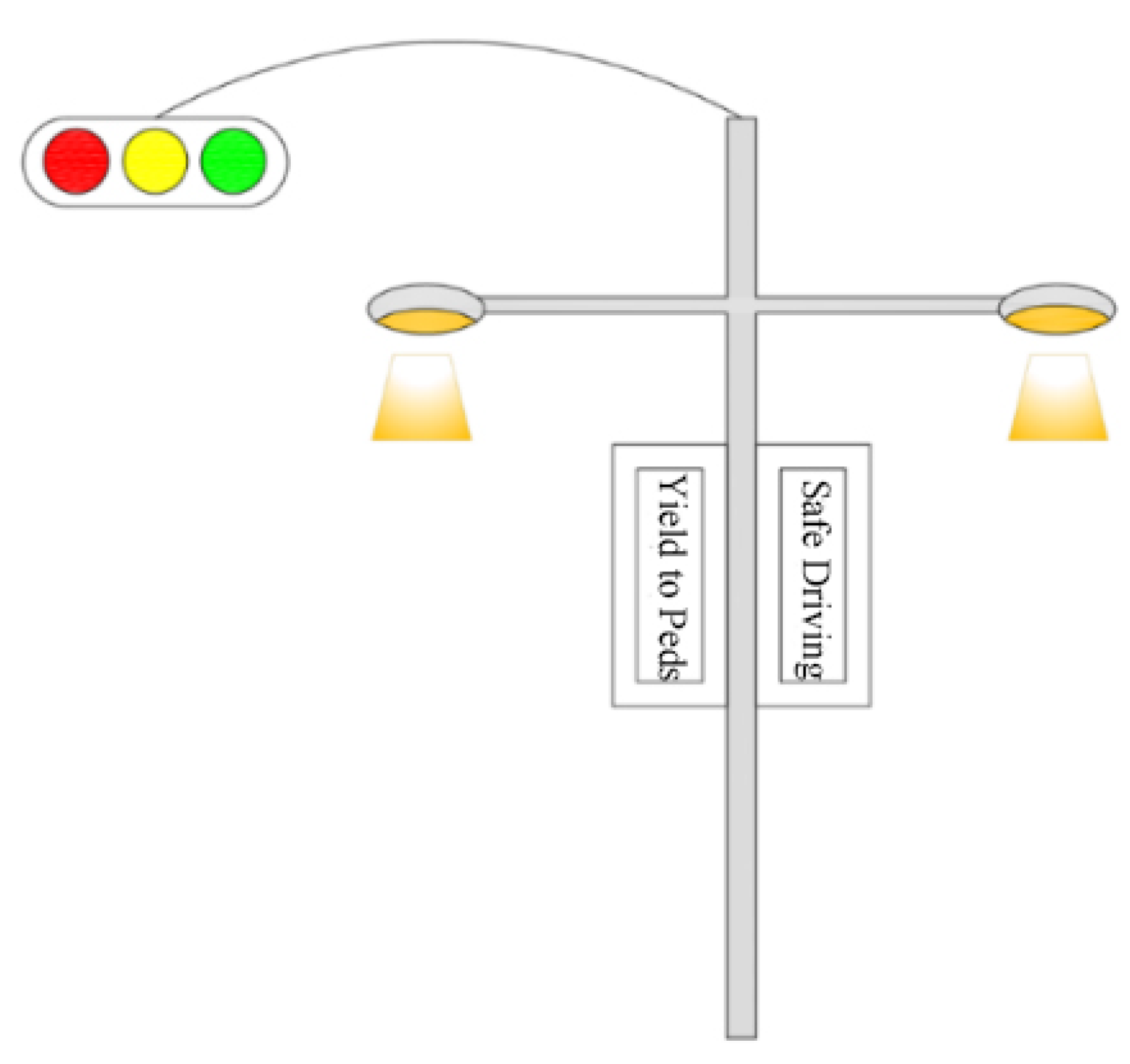
Figure 1. Schematic diagram of “one pole for multiple purposes”.
Sustainability 14 06468 g001
Figure 2. Top view of traffic design for vital street section.
Sustainability 14 06468 g002
Figure 3. Schematic diagram of design elements of walking and activity space in a vital street section.
Sustainability 14 06468 g003
Figure 11. (a) Closed building; (b) retractable building; (c) traditional architecture and sidewalk design; (d) cancel the height difference between building space and sidewalk.
Sustainability 14 06468 g011
Figure 12. Conceptual diagram of theme street section of a vital street.
Sustainability 14 06468 g012
Figure 13. Schematic diagram of median compression at intersection.
Sustainability 14 06468 g013
Figure 14. (a) Schematic diagram of non-motorized lane without right turn lane; (b) schematic diagram of right turn lane in non-motorized lane; (c) design drawing of non-motorized lane at a vital street intersection.
Sustainability 14 06468 g014aSustainability 14 06468 g014b
Figure 15. (a) “Sight distance triangle” of intersection; (b) intersection pedestrian waiting area sunshade.
Sustainability 14 06468 g015
Figure 16. Four phase signal scheme I. (a) phase one; (b) phase two; (c) phase three; (d) phase four.
Sustainability 14 06468 g016
Figure 17. Four phase signal scheme II. (a) phase one; (b) phase two; (c) phase three; (d) phase four.
Sustainability 14 06468 g017
Figure 18. Four phase signal scheme III. (a) phase one; (b) phase two; (c) phase three; (d) phase four.
Sustainability 14 06468 g018
Figure 19. Four phase signal scheme IV (a) phase one; (b) phase two; (c) phase three; (d) phase four.
Sustainability 14 06468 g019
Figure 20. Phase change pedestrian non-motor vehicle and vehicle conflict situation I.
Sustainability 14 06468 g020
Figure 21. Phase change pedestrian non-motor vehicle and vehicle conflict situation II.
Sustainability 14 06468 g021
Figure 22. Schematic diagram of vital street phase signal control design.
Sustainability 14 06468 g022
Figure 23. (a) Schematic diagram of traffic organization of non-motor vehicle crossing street; (b) schematic diagram of pedestrian crossing organization.
Sustainability 14 06468 g023
Figure 24. (a) Three-dimensional crosswalks. (b) Colored crosswalks.
Sustainability 14 06468 g024
Figure 25. Artistic public leisure seats in the activity space at the intersection. (a) Example 1; (b) Example 2.
Sustainability 14 06468 g025
Figure 26. Geographical location of Zhongshan Avenue in Wuhan city.
Sustainability 14 06468 g026
Figure 27. Schematic diagram of Zhongshan Avenue reconstruction project in Wuhan city.
Sustainability 14 06468 g027
Figure 28. The age structure of respondents in Zhongshan Avenue.
Sustainability 14 06468 g028
Figure 29. Transportation options for pedestrians to reach Zhongshan Avenue.
Sustainability 14 06468 g029
Figure 30. Transportation options for pedestrians to leave Zhongshan Avenue.
Sustainability 14 06468 g030
Figure 31. Wuhan Zhongshan Avenue traffic design location map.
Sustainability 14 06468 g031
Figure 32. Standard cross section of east Zhongshan Avenue (Yiyuan Road-Huangpu Street).
Sustainability 14 06468 g032
Figure 33. (a) Graphic design of east Zhongshan Avenue (Yiyuan Road-Huangpu Street); (b) design plan of the intersection of Zhongshan Avenue.
Sustainability 14 06468 g033
Table 1. Statistical table of travel purpose survey on Zhongshan Avenue.
Travel PurposeGo and from WorkEntertainmentTo Visit Friends and
Relatives
weekdays22%69%9%
weekends18%68%14%
Table 2. Statistical table of survey on suggestions for improving riding environment on Zhongshan Avenue in Wuhan.
Environmental Improvement ProposalsSet Up Non-Motor
Vehicle Lane
Additional Public Bicycle SpotsSet the Bike
Parking Position
Other
weekdays44%25%27%4%
weekends46%27%23%4%
Publisher’s Note: MDPI stays neutral with regard to jurisdictional claims in published maps and institutional affiliations.