Ecosystem-Based MSP for Enhanced Fisheries Sustainability: An Example from the Northern Adriatic (Chioggia—Venice and Rovigo, Italy)

 ,
,  , ,
, ,  , ,
, ,  ,
,
Abstract
1. Introduction
2. Materials and Methods
2.1. Case Study: Environmental Features, Human Activities, Existing Environmental, and Resources Protection Measures
2.2. Analyses
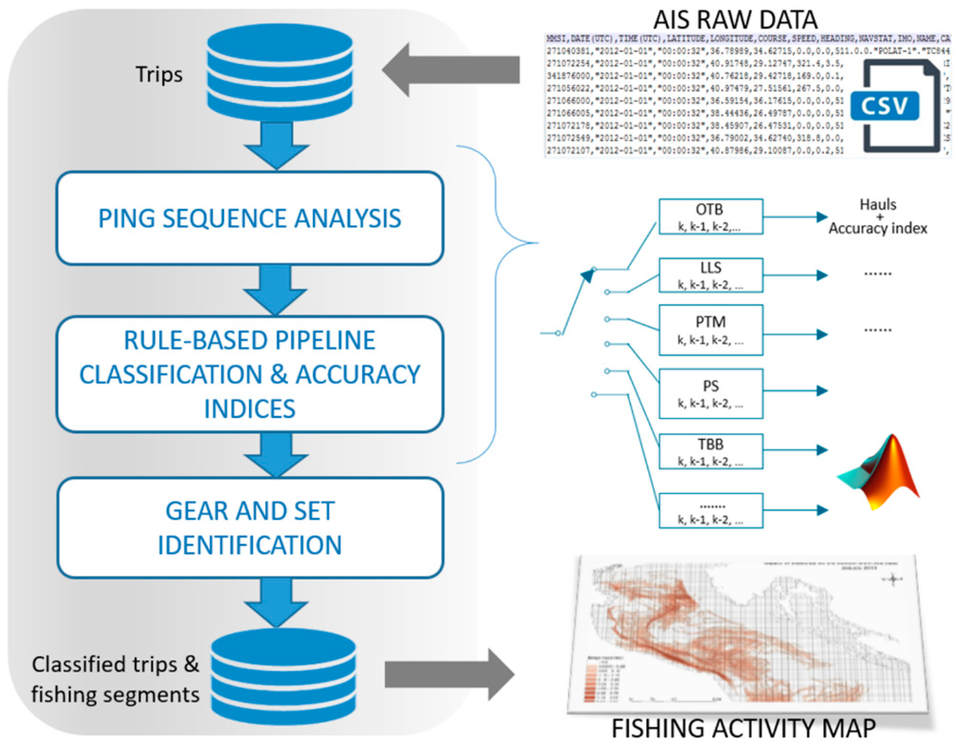
2.2.1. AIS Data Processing
- Raw Data Cleaning: identifying and editing/deleting outliers, such as pings in land and/or far away from preceding and following transmissions;
- Fishing trip identification: partitioning strings of consecutive AIS records for each unique Maritime Mobile Service Identity (MMSI) into individual trips, from the time vessels leave a port to the time they return to a port. An ad-hoc algorithm was developed in Matlab software to identify individual trips, requiring a number of nuanced steps to fix data issues, such as missing AIS transmissions in close proximity to ports and vessels steaming near the coast. Fishing trips were stored in the spatial database along with inherited geographical attributes (ports, countries, and GSAs of departure and landing) and additional trip metrics were computed such as duration and percentage of data gaps due either to intentional switch off by fishermen or transmission issues (i.e., in regions with high maritime traffic or missing terrestrial receivers along the coastlines).
- Assignment of the fishing gear: a rule-based machine learning was used to characterize single trips and to identify the type of fishing, based on GPS values and profiles of speed and course and additional gear-specific movement patterns (e.g., duration of the fishing trip and operations, course values during the hauling, and time gap between subsequent hauls). A set of algorithms were developed using Matlab software environment to incorporate prior domain knowledge for different gear types and executed in sequence to label single trips according to predefined gear classes: bottom otter trawl, beam trawl, pelagic trawl, purse seine, longline, and “other” fishing (including nets and traps).
- The algorithms were designed for each of the predefined gear classes and then a rule-based decision was taken to uniquely assign a gear type to each month on the basis of single answers (given by algorithms for each trip). Decisions were taken on a monthly basis and weighting only “stable” fishing trips that were more robustly classified, such as those with at least 30 transmissions and with a percentage of data gaps non-exceeding 90%. Given the above, the current rule-based system was able to question trip-level outliers (i.e., erroneous gear detection due to a poor data coverage), impose the predominant monthly gear type in use and/or validate real changes in fishing behavior, such as when vessels rotate fishing gears.
- Fishing segment identification: once trips had been labeled according to the gear type, hauls were extracted when fishing vessels were likely engaging in fishing operations. Extracted fishing segments were stored in the single spatial database and ready to be aggregated and binned into grid cells. Segments were stored along with their attributes (MMSI, number of pings, speed class, distances, and duration) and related parent tables (trip ID and raw pings).
- Finally, the intensity of fishing operations was mapped on a monthly and yearly basis and the output was represented on 1 km × 1 km grid cells, and populated with different metrics of fishing effort (i.e., fishing time and swept length). Annual/monthly fishing effort estimates were quantified in each grid cell spatial joining overlapping portions of hauls, and summing relative durations and lengths.
2.2.2. Data Collection and Preparation for DST
2.2.3. Maritime Use Conflict (MUC) Analysis
2.2.4. Cumulative Effect (CEA) Analysis
2.2.5. Stakeholder Engagement
2.3. Management Framework Proposal
3. Results
3.1. Overall Results
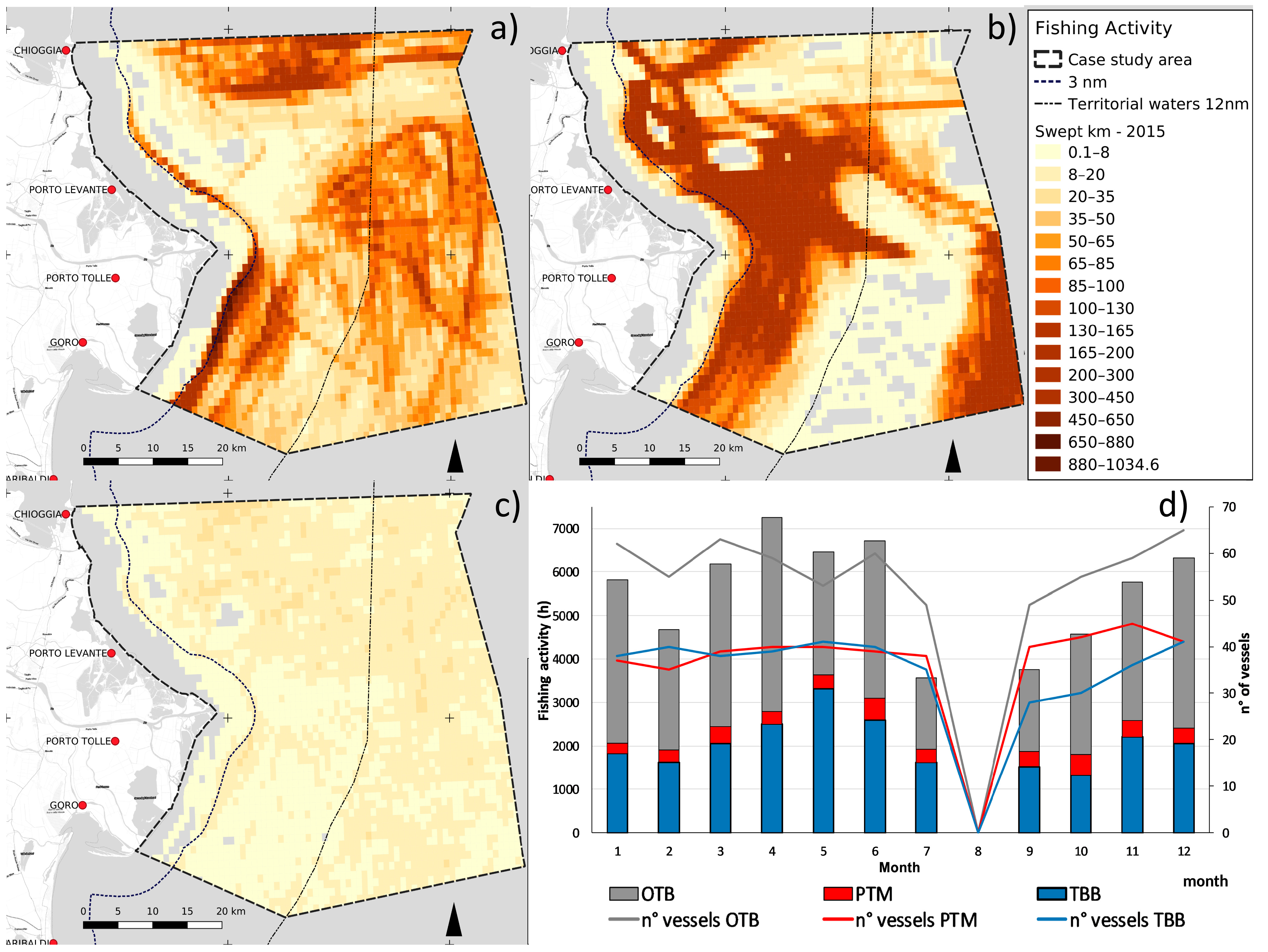
3.1.1. Fishing Activity from AIS Data
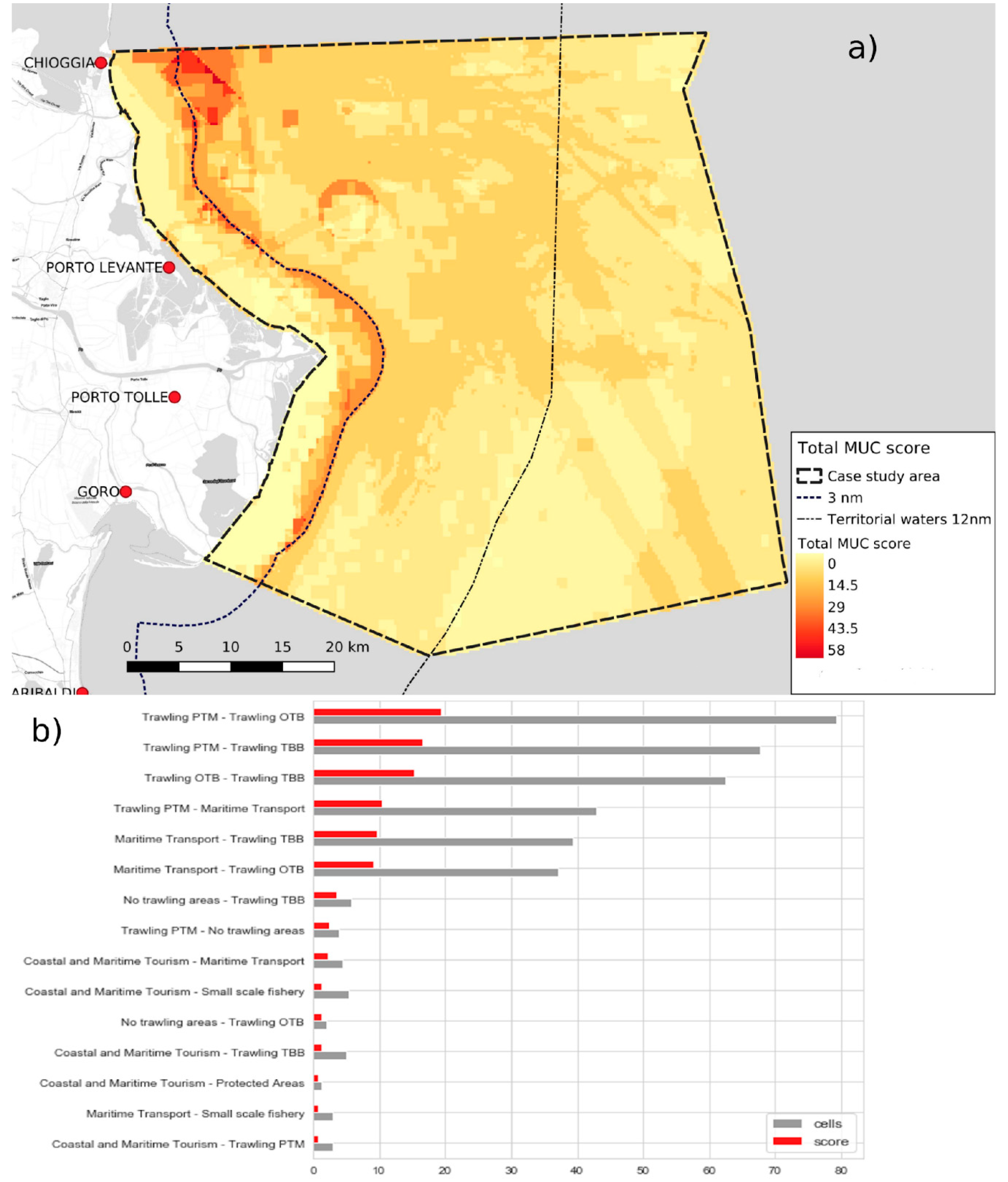
3.1.2. Maritime Use Conflict (MUC) Analysis
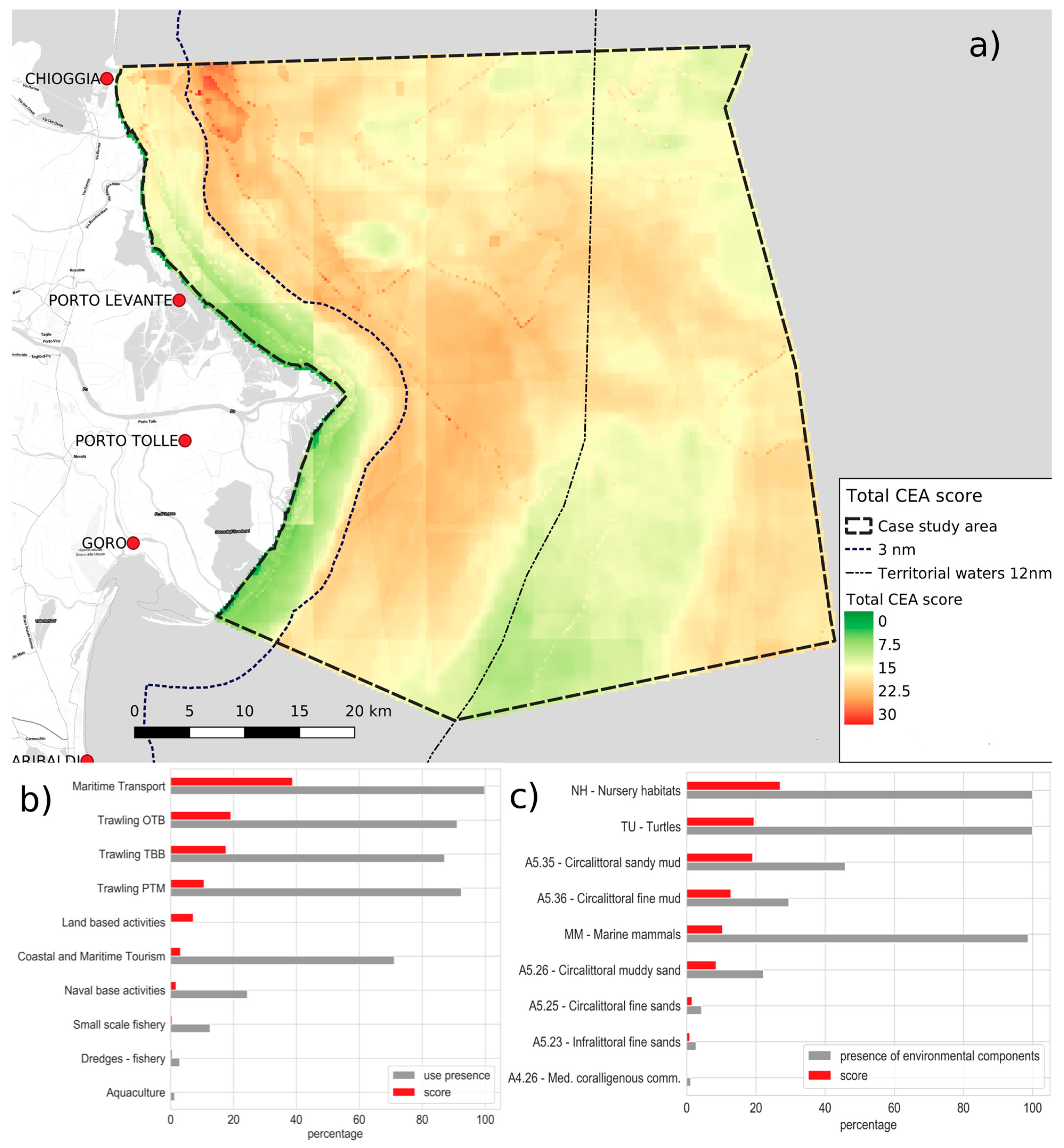
3.1.3. Cumulative Effect (CEA) Analysis
3.2. Management Framework Proposal
3.2.1. Priorities for Long-Term Sustainable Fisheries in the Area
3.2.2. Measure Typologies
3.2.3. Possible Management Measures
4. Discussion
5. Conclusions
Author Contributions
Funding
Institutional Review Board Statement
Informed Consent Statement
Data Availability Statement
Acknowledgments
Conflicts of Interest
Appendix A. Management Measures
Appendix A.1. Issue A. Conflicts between Fishing Segments
Appendix A.2. Issue B. Sustainability of Fishing Effort
Appendix A.3. Issue C. Rules Enforcement
Appendix A.4. Issue D. Impacts of Fisheries on Vulnerable Species and Valuable Environmental Components
Appendix A.5. Issue E. Fragmentation of the Sector
Appendix A.6. Issue F. Relationships with Other National and Foreign Fisheries and Common Rules
Appendix A.7. Issue G. Synergies between Fishing, Aquaculture and Other Uses of the Sea
Appendix A.8. Issue H. Need to Increase the Whole Product Value Chain
References
- Jouffray, J.; Blasiak, R.; Norstrom, A.; Osterblom, H.; Nystrom, M. The Blue Acceleration: The Trajectory of Human Expansion into the Ocean. One Earth 2020, 2, 43–54. [Google Scholar] [CrossRef]
- Colloca, F.; Cardinale, M.; Maynou, F.; Giannoulaki, M.; Scarcella, G.; Jenko, K.; Bellido, J.M.; Fiorentino, F. Rebuilding Mediterranean fisheries: A new paradigm for ecological sustainability. Fish 2013, 14, 89–109. [Google Scholar] [CrossRef]
- Fortibuoni, T.; Giovanardi, O.; Pranovi, F.; Raicevich, S.; Solidoro, C.; Libralato, S. Analysis of long-term changes in a Mediterranean marine ecosystem based on fishery landings. Front. Mar. Sci. 2017, 4, 33. [Google Scholar] [CrossRef]
- White, P.S.; Pickett, S.T.A. Natural disturbance and patch dynamics: An introduction. In The Ecology of Natural Disturbance and Patch Dynamics; White, P.S., Pickett, S.T.A., Eds.; Academic Press: New York, NY, USA, 1985. [Google Scholar]
- Jennings, S.; Kaiser, M.J. The effects of fishing on marine ecosystems. Adv. Mar. Biol. 1998, 34, 201–352. [Google Scholar]
- FAO. The State of World Fisheries and Aquaculture; FAO: Rome, Italy, 2018; 244p. [Google Scholar]
- Amoroso, R.O.; Pitcher, C.R.; Rijnsdorp, A.D.; Mcconnaughey, R.A.; Parma, A.M.; Suuronen, P.; Eigaard, O.R.; Bastardie, F.; Hintzen, N.T.; Althaus, F.; et al. Bottom trawl fishing footprints on the world’s continental shelves. Proc. Natl. Acad. Sci. USA 2018, 115, E10275–E10282. [Google Scholar] [CrossRef]
- UNEP. 2015. United Nations Environment Programme Mediterranean Action Plan. Adriatic Sea ecology. In Proceedings of the Twelfth Meeting of Focal Points for Specially Protected Areas, Athens, Greece, 25–29 May 2015. [Google Scholar]
- Pascoe, S.; Bustamante, R.; Wilcox, C.; Gibbs, M. Spatial fisheries management: A framework for multi-objective qualitative assessment. Ocean Coast Manag. 2009, 52, 130–138. [Google Scholar] [CrossRef]
- Meaden, G.J.; Aguilar-Manjarrez, J.; Corner, R.A.; O’Hagan, A.M.; Cardia, F. Marine Spatial Planning for Enhanced Fisheries and Aquaculture Sustainability–Its Application in the Near East; FAO Fisheries and Aquaculture Technical Paper; FAO: Rome, Italy, 2016. [Google Scholar]
- Gavaris, S. Fisheries management planning and support for strategic and tactical decisions in an ecosystem approach context. Fish. Res. 2009, 100, 6–14. [Google Scholar] [CrossRef]
- Asche, F.; Garlock, T.M.; Anderson, J.L.; Bush, S.R.; Smith, M.D.; Anderson, C.M.; Chu, J.; Garrett, K.A.; Lem, A.; Lorenzen, K.; et al. Three pillars of sustainability in fisheries. Proc. Natl. Acad. Sci. USA 2018, 115, 11221–11225. [Google Scholar] [CrossRef]
- Kritzer, J.P. Influences of at-sea fishery monitoring on science, management, and fleet dynamics. Aquac. Fish. 2020, 5, 107–112. [Google Scholar] [CrossRef]
- Ehler, C.; Douvere, F. Marine Spatial Planning: A step-by-step approach toward ecosystem-based management. Intergovernmental Oceanographic Commission and Man and the Biosphere Programme. In IOC Manual and Guides No. 53, ICAM Dossier No 6; UNESCO: Paris, France, 2009. [Google Scholar]
- Foley, M.M.; Halpern, B.S.; Micheli, F.; Armsby, M.H.; Caldwell, M.R.; Crain, C.M.; Prahler, E.; Rohr, N.; Sivas, D.; Beck, M.W.; et al. Guiding ecological principles for marine spatial planning. Mar. Policy 2010, 34, 955–966. [Google Scholar] [CrossRef]
- Ansong, J.; Gissi, E.; Calado, H. An approach to ecosystem-based management in maritime spatial planning process. Ocean Coast Manag. 2017, 141, 65–81. [Google Scholar] [CrossRef]
- Long, R.D.; Charles, A.; Stephenson, R.L. Key principles of marine ecosystem-based management. Mar. Policy 2015, 57, 53–60. [Google Scholar] [CrossRef]
- Janßen, H.; Bastardie, F.; Eero, M.; Hamon, K.G.; Hinrichsen, H.-H.; Marchald, P.; Nielsen, J.R.; Le Pape, O.; Schulze, T.; Simons, S.; et al. Integration of fisheries into marine spatial planning: Quo vadis? Estuar. Coast. Shelf Sci. 2018, 201, 105–113. [Google Scholar] [CrossRef]
- Stelzenmüller, V.; Rogers, S.I.; Mills, C.M. Spatio-temporal patterns of fishing pressure on UK marine landscapes, and their implications for spatial planning and management. ICES J. Mar. Sci. 2008, 65, 1081–1091. [Google Scholar] [CrossRef]
- Bastardie, F.; Nielsen, J.R.; Eigaard, O.R.; Fock, H.O.; Jonsson, P.; Bartolino, V. Competition for marine space: Modelling the Baltic Sea fisheries and effort displacement under spatial restrictions. ICES J. Mar. Sci. 2015, 72, 824–840. [Google Scholar] [CrossRef]
- Menegon, S.; Depellegrin, D.; Farella, G.; Gissi, E.; Ghezzo, M.; Sarretta, A.; Venier, C.; Barbanti, A. A modelling framework for MSP-oriented cumulative effect assessment. Ecol. Indic. 2018, 91, 171–181. [Google Scholar] [CrossRef]
- Russo, T.; D’Andrea, L.; Franceschini, S.; Accadia, P.; Cucco, A.; Garofalo, G.; Gristina, M.; Parisi, A.; Quattrocchi, G.; Sabatella, R.F.; et al. Simulating the Effects of Alternative Management Measures of Trawl Fisheries in the Central Mediterranean Sea: Application of a Multi-Species Bio-economic Modeling Approach. Front. Mar. Sci. 2019, 6, 542. [Google Scholar] [CrossRef]
- Pınarbaşı, K.; Galparsoro, I.; Borja, Á.; Stelzenmüller, V.; Ehler, C.N.; Gimpel, A. Decision support tools in marine spatial planning: Present applications, gaps and future perspectives. Mar. Policy 2017, 83, 83–91. [Google Scholar] [CrossRef]
- Nygård, H.; van Beest, F.M.; Bergqvist, L.; Carstensen, J.; Gustafsson, B.G.; Hasler, B.; Schumacher, J.; Schernewski, G.; Sokolov, A.; Zandersen, M.; et al. Decision-Support Tools Used in the Baltic Sea Area: Performance and End-User Preferences. Environ. Manag. 2020. [Google Scholar] [CrossRef]
- Bastardie, F.; Nielsen, J.R.; Miethe, T. DISPLACE: A dynamic, individual-based model for spatial fishing planning and effort displacement—integrating underlying fish population models. Can. J. Fish. Aquat. Sci. 2014, 71, 366–386. [Google Scholar] [CrossRef]
- Benaka, L.R.L.; Sharpe, L.; Abrams, K.; Campbell, M.; Cope, J.; Darby, F.; Dick, E.J.; Hyde, J.; Linton, B.; Lunsford, C.; et al. Action Plan for Fish Release Mortality Science; United States Department of Commerce, NOAA: Washington, DC, USA, 2016; 34p.
- Stelzenmüller, V.; Coll, M.; Cormier, R.; Mazaris, A.D.; Pascual, M.; Loiseau, C.; Claudet, J.; Katsanevakis, S.; Gissi, E.; Evagelopoulos, A.; et al. Operationalizing risk-based cumulative effect assessments in the marine environment. Sci. Total Environ. 2020, 724, 138118. [Google Scholar] [CrossRef] [PubMed]
- Hodgson, E.E.; Halpern, B.S. Investigating cumulative effects across ecological scales. Conserv. Biol. 2019, 33, 22–32. [Google Scholar] [CrossRef] [PubMed]
- Stelzenmüller, V.; Lee, J.; South, A.; Rogers, S.I. Practical tools to support marine spatial planning: A review and some prototype tools. Mar. Policy 2013, 38, 214–227. [Google Scholar] [CrossRef]
- Said, A.; Trouillet, B. Bringing ‘Deep Knowledge’ of Fisheries into Marine Spatial Planning. Marit. Stud. 2020, 19, 347–357. [Google Scholar] [CrossRef]
- Ferrà, C.; Tassetti, A.N.; Grati, F.; Pellini, G.; Polidori, P.; Scarcella, G.; Fabi, G. Mapping change in bottom trawling activity in the Mediterranean Sea through AIS data. Mar. Policy 2018, 94, 275–281. [Google Scholar] [CrossRef]
- Ferrà, C.; Tassetti, A.N.; Armelloni, E.N.; Galdelli, A.; Scarcella, G.; Fabi, G. Using AIS to attempt a quantitative evaluation of unobserved trawling effort in the Mediterranean Sea GSA. Front. Mar. Sci. 2020, 7, 580612. [Google Scholar] [CrossRef]
- Taconet, M.; Kroodsma, D.; Fernandes, J.A. Global Atlas of AIS-Based Fishing Activity—Challenges and Opportunities; FAO: Rome, Italy, 2019. [Google Scholar]
- Russo, T.; Franceschini, S.; D’Andrea, L.; Scardi, M.; Parisi, A.; Cataudella, S. Predicting Fishing Footprint of Trawlers From Environmental and Fleet Data: An Application of Artificial Neural Networks. Front. Mar. Sci. 2019, 6, 670. [Google Scholar] [CrossRef]
- Tassetti, A.N.; Ferrà, C.; Fabi, G. Rating the effectiveness of fishery-regulated areas with AIS data. Ocean Coast Manag. 2019, 175, 90–97. [Google Scholar] [CrossRef]
- Kroodsma, D.A.; Mayorga, J.; Hochberg, T.; Miller, N.A.; Boerder, K.; Ferretti, F.; Wilson, A.; Bergman, B.; White, T.D.; Block, B.A.; et al. Tracking the global footprint of fisheries. Science 2018, 359, 904. [Google Scholar] [CrossRef]
- Sala, E.; Mayorga, J.; Costello, C.; Kroodsma, D.; Palomares, M.L.D.; Pauly, D.; Sumaila, U.R.; Zeller, D. The economics of fishing the high seas. Sci. Adv. 2018, 4, eaat2504. [Google Scholar] [CrossRef]
- Bastardie, F.; Angelini, S.; Bolognini, L.; Fuga, F.; Manfredi, C.; Martinelli, M.; Nielsen, J.R.; Santojanni, A.; Scarcella, G.; Grati, F. Spatial planning for fisheries in the Northern Adriatic: Working toward viable and sustainable fishing. Ecosphere 2017, 8, e01696. [Google Scholar] [CrossRef]
- D’Andrea, L.; Parisi, A.; Fiorentino, F.; Garofalo, G.; Gristina, M.; Cataudella, S.; Russo, T. R: An r package for spatial modelling of fisheries and scenario simulation of management strategies. Methods Ecol. Evol. 2020, 11, 859–868. [Google Scholar] [CrossRef]
- Schultz-Zehden, A.; Weig, B.; Lukic, I. Maritime Spatial Planning and the EU’s Blue Growth Policy: Past, Present and Future Perspectives. In Maritime Spatial Planning; Zaucha, J., Gee, K., Eds.; Springer International Publishing: Cham, Switzerland, 2019; pp. 121–149. [Google Scholar]
- Newell, R.I.E.; Ott, J.A. Macrobenthic Communities and Eutrophication. In Ecosystems at the Land-Sea Margin: Drainage Basins to Coastal Sea; Malone, T.C., Malej, A., Harding, L.W., Smodlaka, N., Turner, E., Eds.; Coastal and Estuarine Studies; American Geophysical Union: Washington DC, USA, 1999; Volume 55, pp. 265–293. [Google Scholar]
- Fortibuoni, T.; Libralato, S.; Raicevich, S.; Giovanardi, O.; Solidoro, C. Coding Early Naturalists’ Accounts into Long-term Fish Community Changes in the Adriatic Sea (1800–2000). PLoS ONE 2010, 5, e15502. [Google Scholar] [CrossRef] [PubMed]
- Tosi, L.; Zecchin, M.; Franchi, F.; Bergamasco, A.; Da Lio, C.; Baradello, L.; Mazzoli, C.; Montagna, P.; Taviani, M.; Tagliapietra, D.; et al. Paleochannel and beach-bar palimpsest topography as initial substrate for coralligenous buildups offshore Venice, Italy. Sci. Rep. 2017, 7, 1321. [Google Scholar] [CrossRef]
- Colloca, F.; Garofalo, G.; Bitetto, I.; Facchini, M.T.; Grati, F.; Martiradonna, A.; Mastrantonio, G.; Nikolioudakis, N.; Ordinas, F.; Scarcella, G.; et al. The Seascape of Demersal Fish Nursery Areas in the North Mediterranean Sea, a First Step Towards the Implementation of Spatial Planning for Trawl Fisheries. PLoS ONE 2015, 10, e0119590. [Google Scholar] [CrossRef]
- Antonini, C.; Donadelli, V.; Finocchiaro, G.; Giovanrdi, O.; Marino, G.; Raicevich, S.; Tomasetti, P. Stock Ittici in Sovrasfruttamento. Capitolo 2. Pesca ed Acquacoltura. Annuario Dei Dati Ambientali 2019. 2020, p. 1. Available online: https://annuario.isprambiente.it/sites/default/files/pdf/2019/versione-integrale/02-Pesca-2019.pdf (accessed on 15 November 2020).
- Micheli, F.; Halpern, B.S.; Walbridge, S.; Ciriaco, S.; Ferretti, F.; Fraschetti, F.; Lewison, R.; Nykjaer, L.; Rosenberg, A. Cumulative Human Impacts on Mediterranean and Black Sea Marine Ecosystems: Assessing Current Pressures and Opportunities. PLoS ONE 2013, 8, e79889. [Google Scholar] [CrossRef]
- EMODnet Human Activities, Download Services. Available online: https://www.emodnet-humanactivities.eu/ (accessed on 1 May 2019).
- EMODnet Seabed Habitats. Download services. Available online: https://www.emodnet.eu/seabed-habitats (accessed on 1 May 2019).
- Tools4MSP Data Portal. Available online: http://data.tools4msp.eu/ (accessed on 1 September 2020).
- Menegon, S.; Depellegrin, D.; Farella, G.; Sarretta, A.; Venier, C.; Barbanti, A. Addressing cumulative effects, maritime conflicts and ecosystem services threats through MSP-oriented geospatial webtools. Ocean Coast Manag. 2018, 163, 417–436. [Google Scholar] [CrossRef]
- Fortuna, C.M.; Cañadas, A.; Holcer, D.; Brecciaroli, B.; Donovan, G.P.; Lazar, B.; Mo, G.; Tunesi, L.; Mackelworth, P.C. The Coherence of the European Union Marine Natura 2000 Network for Wide-Ranging Charismatic Species: A Mediterranean Case Study. Front. Mar. Sci. 2018, 5, 356. [Google Scholar] [CrossRef]
- Telesca, L.; Belluscio, A.; Criscoli, A.; Ardizzone, G.; Apostolaki, E.; Fraschetti, S.; Gristina, M.; Knittweis, L.; Martin, C.; Pergent, G.; et al. MAREA PROJECT: MEDISEH (Mediterranean Sensitive Habitats) Specific Contract No 2 (SI2.600741); Final Report; Hellenic Centre for Marine Research: Heraklion, Greece, 2013. [Google Scholar]
- Umgiesser, G.; Melaku Canu, D.; Cucco, A.; Solidoro, C. A finite element model for the Venice Lagoon. Development, set up, calibration and validation. J. Mar. Syst. 2004, 51, 123–145. [Google Scholar] [CrossRef]
- Depellegrin, D.; Menegon, S.; Farella, G.; Ghezzo, M.; Gissi, E.; Sarretta, A.; Venier, C.; Barbanti, A. Multi-objective spatial tools to inform maritime spatial planning in the Adriatic Sea. Sci. Total Environ. 2017, 609, 1627–1639. [Google Scholar] [CrossRef]
- Farella, G.; Menegon, S.; Fadini, A.; Depellegrin, D.; Manea, E.; Perini, L.; Barbanti, A. Incorporating Ecosystem Services conservation into a scenario-based MSP framework: An Adriatic case study. Ocean Coast Manag. 2020, 193, 105230. [Google Scholar] [CrossRef]
- Moore, S.A.; Brown, G.; Kobryn, H.; Strickland-Munro, J. Identifying conflict potential in a coastal and marine environment using participatory mapping. J. Environ. Manag. 2017, 197, 706–718. [Google Scholar] [CrossRef] [PubMed]
- Menegon, S.; Sarretta, A.; Depellegrin, D.; Farella, G.; Venier, C.; Barbanti, A. Tools4MSP: An open source software package to support Maritime Spatial Planning. PeerJ 2018, 4, e165. [Google Scholar] [CrossRef]
- Judd, A.; Backhaus, T.; Goodsir, F. An effective set of principles for practical implementation of marine cumulative effects assessment. Environ. Sci. Policy 2015, 54, 254–262. [Google Scholar] [CrossRef]
- Raicevich, S.; Dubois, M.; Bullo, M.; Franceschini, G.; Mion, M.; Nalon, N.; Piras, C.; Sabatini, L.; Fortibuoni, T.; Celić, I.; et al. The Italian Job: Navigating the (Im)Perfect Storm of Participatory Fisheries Research in the Northern Adriatic Sea. In Collaborative Research in Fisheries; Holm, P., Hadjimichael, M., Linke, S., Mackinson, S., Eds.; MARE Publication Series; Springer: Cham, Switzerland, 2020; Volume 22. [Google Scholar]
- Twomey, S.; O’Mahony, C. Stakeholder Processes in Marine Spatial Planning: Ambitions and Realities from the European Atlantic Experience. In Maritime Spatial Planning; Zaucha, J., Gee, K., Eds.; Palgrave Macmillan: Cham, Switzerland, 2019. [Google Scholar]
- Morf, A.; Kull, M.; Piwowarczyk, J.; Gee, K. Towards a Ladder of Marine/Maritime Spatial Planning Participation. In Maritime Spatial Planning; Zaucha, J., Gee, K., Eds.; Palgrave Macmillan: Cham, Switzerland, 2019. [Google Scholar]
- Farella, G.; Raicevich, S.; Bocci, M.; Tassetti, A.N.; Menegon, S.; Giovanardi, O.; Ferrà, C.; Grati, F.; Fabi, G.; Barbanti, A. Progetto NORA—Sviluppo di strumenti a sostegno della governance partecipata degli usi del mare nel Compartimento marittimo di Chioggia. PdA FLAG GAC Chioggia Delta del Po 2014–2020. Final. Rep. 2019, 175. [Google Scholar] [CrossRef]
- Piras, C.; Mion, M.; Fortibuoni, T.; Franceschini, G.; Punzo, E.; Strafella, P.; Despalatović, M.; Cvitković, I.; Raicevich, S. A photographic method to identify benthic assemblages based on demersal trawler discards. Fish. Res. 2016, 178, 142–151. [Google Scholar] [CrossRef]
- Coll, M.; Piroddi, C.; Albouy, C.; Ben Rais Lasram, F.; Cheung, W.W.L.; Christensen, V.; Karpouzi, V.S.; Guilhaumon, F.; Mouillot, D.; Paleczny, M.; et al. The Mediterranean Sea under siege: Spatial overlap between marine biodiversity, cumulative threats and marine reserves. Glob. Ecol. Biogeogr. 2012, 21, 465–480. [Google Scholar] [CrossRef]
- Fortibuoni, T.; Libralato, S.; Arneri, E.; Giovanardi, O.; Solidoro, C.; Raicevich, S. Fish and fishery historical data since the 19th century in the Adriatic Sea, Mediterranean. Sci Data 2017, 4, 170104. [Google Scholar] [CrossRef]
- Pranovi, F.; Raicevich, S.; Franceschini, G.; Farrace, M.G.; Giovanardi, O. ‘Rapido’ trawling in the northern Adriatic Sea: Effects on benthic communities in an experimental area. ICES J. Mar. Sci. 2000, 57, 517–524. [Google Scholar] [CrossRef]
- Oberle, F.K.; Storlazzi, C.D.; Hanebuth, T.J. What a drag: Quantifying the global impact of chronic bottom trawling on continental shelf sediment. J. Mar. Syst. 2016, 159, 109–119. [Google Scholar] [CrossRef]
- Russo, T.; Carpentieri, P.; D’Andrea, L.; De Angelis, P.; Fiorentino, F.; Franceschini, S.; Garofalo, G.; Labanchi, L.; Parisi, A.; Scardi, M.; et al. Trends in Effort and Yield of Trawl Fisheries: A Case Study From the Mediterranean Sea. Front. Mar. Sci. 2019, 6, 153. [Google Scholar] [CrossRef]
- Santelli, A.; Cvitković, I.; Despalatović, M.; Fabi, G.; Grati, F.; Marčeta, B.; Punzo, E.; Raicevich, S.; Strafella, P.; Spagnolo, A.; et al. Spatial distribution and temporal persistence of megazoobenthos assemblages in the Adriatic Sea. Mar. Ecol. Prog. Ser. 2017, 566, 31–48. [Google Scholar] [CrossRef]
- Grati, F.; Scarcella, G.; Polidori, P.; Domenichetti, F.; Bolognini, L.; Gramolini, R.; Vasapollo, C.; Giovanardi, O.; Raicevich, S.; Celić, I.; et al. Multi-annual investigation of the spatial distributions of juvenile and adult sole (Solea solea L.) in the Adriatic Sea (northern Mediterranean). J. Sea Res. 2013, 84, 122–132. [Google Scholar] [CrossRef]
- Bearzi, G.; Fortuna, C.M.; Reeves, R.R. Ecology and conservation of common bottlenose dolphins Tursiops truncatus in the Mediterranean Sea. Mammal Rev. 2008, 39, 92–123. [Google Scholar] [CrossRef]
- Casale, P.; Freggi, D.; Furii, G.; Vallini, C.; Salvemini, P.; Deflorio, M.; Totaro, G.; Raimondi, S.; Fortuna, C.; Godley, B. Annual survival probabilities of juvenile loggerhead sea turtles indicate high anthropogenic impact to Mediterranean populations. Aquatic Conserv: Mar. Freshw. Ecosyst. 2015, 25, 690–700. [Google Scholar] [CrossRef]
- Lucchetti, A.; Angelini, V.; Furii, G.; Pari, S.; Vasapollo, C.; Virgili, M. Evidence of loggerhead sea turtle (Caretta caretta, Linnaeus, 1758) injuries caused by Rapido (beam) trawling in the Mediterranean. Herpetol. J. 2018, 28, 134–136. [Google Scholar]
- Bonizzoni, S.; Furey, N.B.; Bearzi, G. Bottlenose dolphins (Tursiops truncatus) in the north-western Adriatic Sea: Spatial distribution and effects of trawling. Aquat. Conserv. Mar. Freshw Ecosyst. 2020, 1–16. [Google Scholar] [CrossRef]
- Dureuil, M.; Boerder, K.; Burnett, K.A.; Froese, R.; Worm, B. Elevated trawling inside protected areas undermines conservation outcomes in a global fishing hot spot. Science 2018, 362, 1403–1407. [Google Scholar] [CrossRef]
- Scarcella, G.; Grati, F.; Raicevich, S.; Russo, T.; Gramolini, R.; Scott, R.D.; Polidori, P.; Domenichetti, F.; Bolognini, L.; Giovanardi, O.; et al. Common sole in the northern and central Adriatic Sea: Spatial management scenarios to rebuild the stock. J. Sea Res. 2014, 89, 12–22. [Google Scholar] [CrossRef]
- Lucchetti, A.; Pulcinella, J.; Angelini, V.; Pari, S.; Russo, T.; Cataudella, S. An interaction index to predict turtle bycatch in a Mediterranean bottom trawl fishery. Ecol. Ind. 2016, 60, 557–564. [Google Scholar] [CrossRef]
- Agnetta, D.; Badalamenti, F.; D’Anna, G.; Sinopoli, M.; Andaloro, F.; Vizzini, S.; Pipitone, C. Sizing up the role of predators on Mullus barbatus populations in Mediterranean trawl and no-trawl areas. Fish. Res. 2019, 213, 196–203. [Google Scholar] [CrossRef]
- Shabtay, A.; Portman, M.E.; Manea, E.; Gissi, E. Promoting ancillary conservation through marine spatial planning. Sci. Total Environ. 2019, 651, 1753–1763. [Google Scholar] [CrossRef] [PubMed]
- O’Keefe, C.E.; Cadrin, S.X.; Stokesbury, K.D.E. Evaluating effectiveness of time/area closures, quotas/caps, and fleet communications to reduce fisheries bycatch. ICES J. Mar. Sci. 2014, 71, 1286–1297. [Google Scholar] [CrossRef]
- Santana-Garcon, J.; Wakefield, C.B.; Dorman, S.R.; Denham, A.; Blight, S.; Molony, B.W.; Newman, S.J. Risk versus reward: Interactions, depredation rates and bycatch mitigation of dolphins in demersal fish trawls. Can. J. Fish. Aquat. Sci. 2018, 75, 2233–2240. [Google Scholar] [CrossRef]
- Lucchetti, A.; Sala, A. An overview of Loggerhead sea turtle (Caretta caretta) bycatch and technical mitigation measures in the Mediterranean Sea. Rev. Fish Biol. Fish. 2009, 20, 141–161. [Google Scholar] [CrossRef]
- Wakefield, C.B.; Santana-Garcon, J.; Dorman, S.R.; Blight, S.; Denham, A.; Wakeford, J.; Molony, B.W.; Newman, S.J. Performance of bycatch reduction devices varies for chondrichthyan, reptile, and cetacean mitigation in demersal fish trawls: Assimilating subsurface interactions and unaccounted mortality. ICES J. Mar. Sci. 2017, 74, 343–358. [Google Scholar] [CrossRef]
- Muñoz, M.; Reul, A.; Gil de Sola, L.; Lauerburg, R.A.M.; Tello, O.; Gimpel, A.; Stelzenmüller, V. A spatial risk approach towards integrated marine spatial planning: A case study on European hake nursery areas in the North Alboran Sea. Mar. Environ. Res. 2018, 142, 190–207. [Google Scholar] [CrossRef]
- Depellegrin, D.; Venier, C.; Kyriazi, Z.; Vassilopoulou, V.; Castellani, C.; Ramieri, E.; Bocci, M.; Fernandez, J.; Barbanti, A. Exploring Multi-Use potentials in the Euro-Mediterranean sea space. Sci. Total Environ. 2019, 653, 612–629. [Google Scholar] [CrossRef]
- Ramírez, F.; Coll, M.; Navarro, J.; Bustamante, J.; Green, A.J. Spatial congruence between multiple stressors in the Mediterranean Sea may reduce its resilience to climate impacts. Sci. Rep. 2018, 8, 14871. [Google Scholar] [CrossRef]
- Frazão Santos, C.; Agardy, T.; Andrade, F.; Calado, H.; Crowder, L.B.; Ehler, C.N.; García-Morales, S.; Gissi, E.; Halpern, B.S.; Orbach, M.K.; et al. Integrating climate change in ocean planning. Nat. Sustain. 2020, 3, 505–516. [Google Scholar] [CrossRef]
- Da Lio, C.; Tosi, L. Vulnerability to relative sea-level rise in the Po river delta (Italy). Estuar. Coast. Shelf Sci. 2019, 228, 106379. [Google Scholar] [CrossRef]
- Gaines, S.D.; Costello, C.; Owashi, B.; Mangin, T.; Bone, J.; Molinos, J.G.; Burden, M.; Dennis, H.; Halpern, B.S.; Kappel, C.V.; et al. Improved fisheries management could offset many negative effects of climate change. Sci. Adv. 2018, 4, 8–eaao1378. [Google Scholar] [CrossRef] [PubMed]
- Gissi, E.; Menegon, S.; Sarretta, A.; Appiotti, F.; Maragno, D.; Vianello, A.; Depellegrin, D.; Venier, C.; Barbanti, A. Addressing uncertainty in modelling cumulative impacts within maritime spatial planning in the Adriatic and Ionian region. PLoS ONE 2017, 12, e0180501. [Google Scholar] [CrossRef] [PubMed]


| Human Use | Description | Unit | Source |
|---|---|---|---|
| Aquaculture | Aquaculture (Veneto Region—2015) | P/A | Veneto Region—2015 |
| Cables and Pipelines | LNG submarine pipelines | P/A | Veneto Region—2015 |
| Coastal and Maritime Tourism | Bathing waters | P/A | SHAPE Project |
| Marinas—Italy | Nr of berth | PagineAzzurre.com (elaboration Tools4MSP) | |
| Land Based Activities | Modeled land based pressures from rivers into the Adriatic Sea | Index (1—high contribution to 0—no contribution) | SHYFEM (Shallow water Hydrodynamic Finite Model) |
| Liquefied natural gas plant (LNG) | LNG terminal “Adriatic LNG” | P/A | Veneto Region—2015 |
| Maritime Transport | Adriatic traffic density July 2014—June 2015 | Ship passages/cell | BALMAS project (www.balmas.eu), elaboration Tools4MSP |
| Naval base activities | Cruise Ports 2015 | Nr of cruises | [47] |
| Main Ports (Total shipped goods) 2015–2016 | Tons | [47] | |
| Oil & Gas extraction | EMODNET Hydrocarbon Extraction—Offshore Installations | P/A | [47] |
| Small scale fishery | Small scale fisheries (e.g., Set gillnets, purse seines, traps, etc.) | Total operations | FAO-ADRIAMED data, 2015 |
| Hydraulic dredges | Hydraulic dredges for clam fisheries | Total operations | [49] |
| Mid-water pelagic trawling (PTM) | Pelagic trawl from AIS 2015 | Swept length (km) | See Section 2.2.1 |
| Bottom trawling (OTB) | Bottom otter trawl from AIS 2015 | Swept length (km) | See Section 2.2.1 |
| Beam trawling (TBB) | Beam trawl from AIS 2015 | Swept length (km) | See Section 2.2.1 |
| Environmental Component | Description | Unit | Source |
|---|---|---|---|
| Marine seabed habitats | EUNIS A4.26—Mediterranean coralligenous communities | P/A | [48] |
| EUNIS A5.23—Infralittoral fine sands | |||
| EUNIS A5.25—Circalittoral fine sands | |||
| EUNIS A5.26—Circalittoral muddy sand | |||
| EUNIS A5.33—Infralittoral sandy mud | |||
| EUNIS A5.35—Circalittoral sandy mud | |||
| EUNIS A5.36—Circalittoral fine mud | |||
| MM—Marine mammals | Tursiops truncatus predicted density in the Adriatic Sea (2010–2013) | Density (nr of animals/100 km2) categories | [51] |
| EFH—Essential Fish Habitats | Engraulis encrasicolus (European anchovy) spawners | Probability of occurrence | MAREA-MEDISEH Project [52] |
| Pagellus erythrinus (Common Pandora) recruits | |||
| Solea solea (Common sole) recruits | |||
| Trachurus mediterraneus (Mediterranean horse mackerel) recruits | |||
| Trachurus trachurus (Atlantic horse mackerel) recruits | |||
| Sardina pilchardus (European pilchard) spawners | |||
| Scomber colias (Atlantic chub mackerel) spawners | |||
| Scomber colias (Atlantic chub mackerel) recruits | |||
| Scomber scombrus (Atlantic mackerel) recruits | |||
| Mullus barbatus (Red mullet) recruits | |||
| Engraulis encrasicolus (European anchovy) recruits | |||
| Sardina pilchardus (European pilchard) recruits | |||
| Solea solea (Common sole) spawners | |||
| TU—Turtles | Caretta caretta predicted density in the Adriatic Sea (2010–2013) | Density (nr of animals/100 km2) categories | [51] |
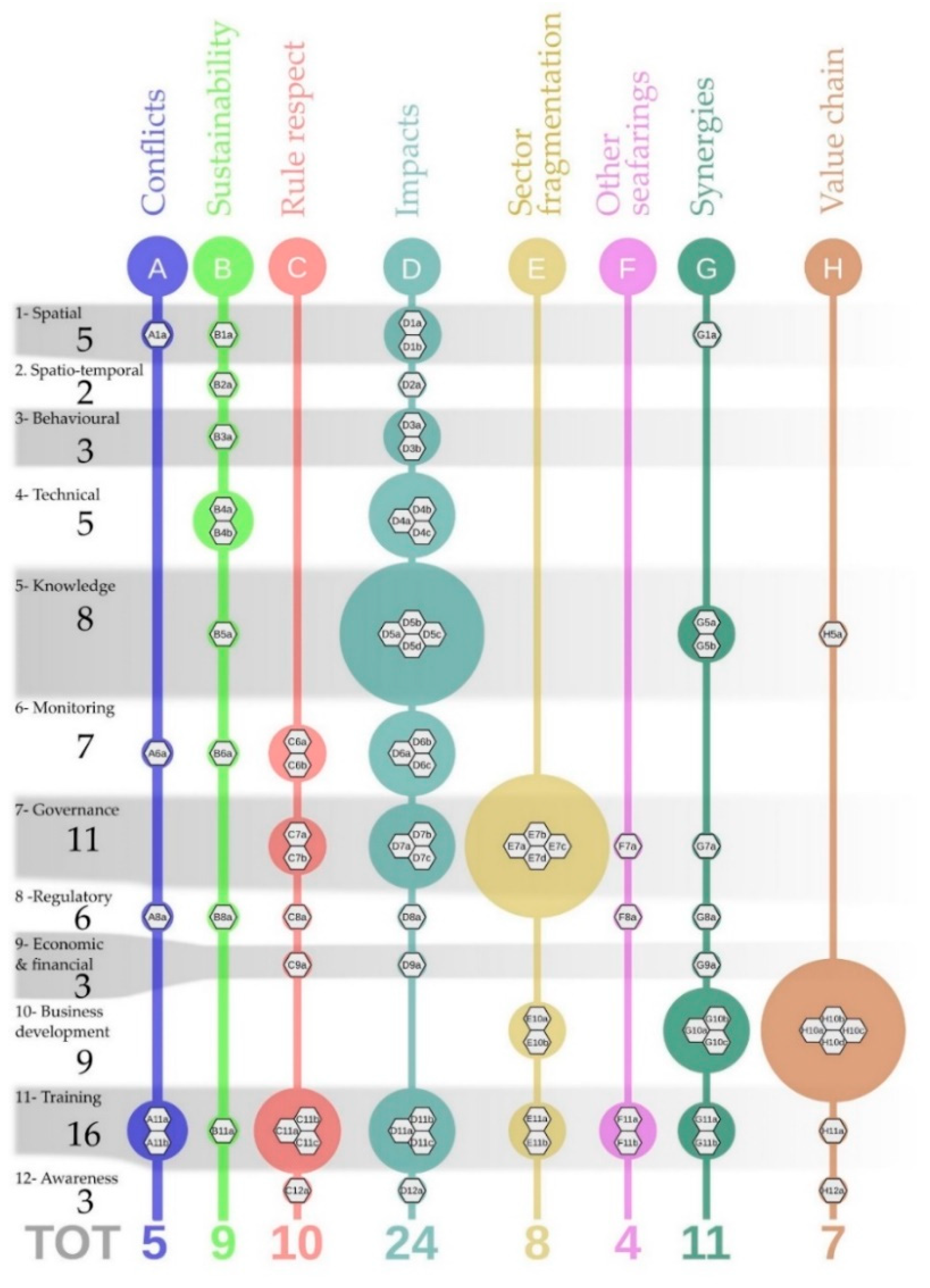
| Title | Description | |
|---|---|---|
| A | Conflicts between fishing segments | Conflicts exist between small-scale fishing and bottom trawling and between different types of bottom trawling. |
| B | Sustainability of fishing effort | Spatial, temporal, and space-time measures for the sustainable management of fishing activities are already in place. These actions need to be updated, based on results achieved so far and new policies. |
| C | Rules enforcement | Effectiveness of the measures in place is compromised by infringements. |
| D | Impacts of fisheries on vulnerable species and valuable environmental components | Techniques and practices can be developed and tested, also with the contribution of operators, to minimize the negative effects of fishing on some species in particular (e.g., bottlenose dolphins, turtles, and non-target fish species), on habitats (e.g., bioconstructions, bottom communities) or ecosystems. |
| E | Fragmentation of the sector | Fragmentation in the sector impairs innovation and the diversification capacities, makes it less representative in decision-making contexts, and increases internal conflicts. |
| F | Lack of common rules | The study area is used not only by local fisheries but also by fisheries from neighboring fishing ports, such as Rimini and Cesenatico (Emilia-Romagna Region) and Ancona (Marche Region). Furthermore, there is competition for resources and shared markets with foreign fisheries, in particular with the Croatian one. When the space-time regulations in place are different, disadvantages—and consequently conflicts—may arise for one or the other part. |
| G | Synergies between fishing, aquaculture and other uses of the sea | In a context of lower and lower profitability in the sector, developing innovative activities, complementary to fishing, represents an opportunity for integration of income. The environmental, historical and cultural richness of the case study area creates a favorable context for the development of synergies between the fishing sector and other uses of the sea such as tourism and recreation. |
| H | Need to increase the whole product value chain | The current organization of product distribution—including competition from abroad—determines the race for lower and lower prices. With higher value of product, catches could be reduced because fishermen could get the same income with a lower number of fishing days. |
| Title | Description | |
|---|---|---|
| 1 | Spatial measures | Measures regulating fishing with reference to specific areas |
| 2 | Spatial-Temporal measures | Measures regulating fishing with reference to specific areas and periods |
| 3 | Behavioral measures | Measures sustaining good fishing practices and minimizing environmental impacts |
| 4 | Technical and technological improvements | Measures concerning boats and their components, methods of navigation and fishing, tools, devices, products, processes, and any element useful to improve the sustainability of fishing activities |
| 5 | Knowledge measures | Aimed at increasing knowledge on the characteristics of the sea and marine ecosystems in the study area, on fishing practices and their effects, on other coastal and maritime activities that interact with fishing |
| 6 | Monitoring, control and surveillance | Aimed at measuring the trend of parameters relating to fishing activities and the characteristics of marine ecosystems; and monitoring compliance with rules and regulations relating to fishing activities in force in the study area. |
| 7 | Multi-level governance | Measures aimed at improving the organization and management of fishing activities; |
| 8 | Regulations and administrative measures | Measures aimed at the optimization and rationalization of regulations and bureaucracy of the sector |
| 9 | Economic and financial measures | Measures dealing with economic aspects (including taxation) and aimed to identify financial resources to support the performance and the start-up of activities, including innovative ones (e.g., incentives, financing, and indemnities) |
| 10 | Entrepreneurial development and marketing | Measures aimed at increasing the entrepreneurial capacity of operators, including organizational and representative aspects, and the ability to commercialize the product |
| 11 | Training and engagement of operators | Measures aimed at training of fishing operators on specific technical topics and encouraging the active participation in decision-making and management processes |
| 12 | Education and awareness raising of the public | Measures aimed at informing consumers about fishing activities and their products, with particular reference to the seasonality of species, lesser known species, the need to prefer local products, and fished with sustainable techniques. |
Publisher’s Note: MDPI stays neutral with regard to jurisdictional claims in published maps and institutional affiliations. |
© 2021 by the authors. Licensee MDPI, Basel, Switzerland. This article is an open access article distributed under the terms and conditions of the Creative Commons Attribution (CC BY) license (http://creativecommons.org/licenses/by/4.0/).
Share and Cite
Farella, G.; Tassetti, A.N.; Menegon, S.; Bocci, M.; Ferrà, C.; Grati, F.; Fadini, A.; Giovanardi, O.; Fabi, G.; Raicevich, S.; et al. Ecosystem-Based MSP for Enhanced Fisheries Sustainability: An Example from the Northern Adriatic (Chioggia—Venice and Rovigo, Italy). Sustainability 2021, 13, 1211. https://doi.org/10.3390/su13031211
Farella G, Tassetti AN, Menegon S, Bocci M, Ferrà C, Grati F, Fadini A, Giovanardi O, Fabi G, Raicevich S, et al. Ecosystem-Based MSP for Enhanced Fisheries Sustainability: An Example from the Northern Adriatic (Chioggia—Venice and Rovigo, Italy). Sustainability. 2021; 13(3):1211. https://doi.org/10.3390/su13031211
Chicago/Turabian StyleFarella, Giulio, Anna Nora Tassetti, Stefano Menegon, Martina Bocci, Carmen Ferrà, Fabio Grati, Amedeo Fadini, Otello Giovanardi, Gianna Fabi, Saša Raicevich, and et al. 2021. "Ecosystem-Based MSP for Enhanced Fisheries Sustainability: An Example from the Northern Adriatic (Chioggia—Venice and Rovigo, Italy)" Sustainability 13, no. 3: 1211. https://doi.org/10.3390/su13031211
APA StyleFarella, G., Tassetti, A. N., Menegon, S., Bocci, M., Ferrà, C., Grati, F., Fadini, A., Giovanardi, O., Fabi, G., Raicevich, S., & Barbanti, A. (2021). Ecosystem-Based MSP for Enhanced Fisheries Sustainability: An Example from the Northern Adriatic (Chioggia—Venice and Rovigo, Italy). Sustainability, 13(3), 1211. https://doi.org/10.3390/su13031211