Article

3D Underground Property Rights of Transportation Infrastructures: Case Study of Piraeus Metro Station, Greece

by
Dionysia-Georgia Perperidou
1,*,
Konstantinos Sigizis
2 and
Agkronilnta Chotza
1
1
Department of Surveying and Geoinformatics Engineering, University of West Attica, Egaleo Park, Ag. Spyridonos Str., 12243 Athens, Greece
2
Independent Researcher, 13676 Athens, Greece
*
Author to whom correspondence should be addressed.
Sustainability 2021, 13(23), 13162; https://doi.org/10.3390/su132313162
Submission received: 11 October 2021 / Revised: 24 November 2021 / Accepted: 24 November 2021 / Published: 27 November 2021
(This article belongs to the Section Sustainable Urban and Rural Development)

Abstract

:
Underground development covers a wide range of underground uses, transportation and infrastructures networks; water and energy storage facilities; municipal spaces, housing, business and manufacturing facilities; and overall exploitation of Urban Underground Space (UUS). According to the Greek legal framework on properties underground, transportation networks, such as the metro, are developed deep enough that no compensation is due to surface parcel owners, which are usually a public entity. The current Greek cadastral system is two-dimensional and there are no records for underground transportation networks. As the need for the exploitation of UUS is arising, especially in densely populated Greek cities, such as Athens, the detailed documentation of transportation networks 3D underground property rights is essential. Herein is presented the technical and legal definition of the 3D underground property rights of the Piraeus Metro Station that is constructed in Piraeus Municipality UUS. Three-dimensional underground models for both Piraeus Station and official cadastral parcels are created so as to identify their 3D spatial intersection. For the identification of their legal and spatial status in 2D, the UUS was subdivided into layers in respect to the station’s vertical infrastructure and then correlated to the current cadastral 2D spatial data. The presented 3D underground property rights of Greece’s major urban underground transportation network facilitates its registration in the current 2D Greek cadastral system and contributes to the better understanding and the identification of legal and technical aspects of UUS rights in Greece.

1. Introduction

Vast urbanization and the overpopulation of cities made inevitable the use and disposal of Urban Underground Space (UUS, as by 2030, the urban population will reach 5.17 billion, two-thirds of the estimated total world population [1]). UUS originally was mainly used for the development of urban transportations networks, especially the Metro, storage facilities and infrastructures facilities that were considered as space consuming when developed over the ground. Gradually, and as cities kept expanding and became overpopulated, UUS became a vital resource for cities’ sustainable development [2] and an essential aspect in the overall planning process [3,4,5]. In China and Japan, UUS development is already incorporated into the overall urban planning processes [6] for a wide range of activities and land uses, e.g., transportation and infrastructures networks, water, energy and utility networks facilities, community and municipal spaces, housing and business and manufacturing facilities [7]. As UUS development is incorporated in urban development and urban planning, important issues arise, such as estimating underground land values [8] that are also related to environmental benefits from underground urban development [9], analyzing underground land uses in respect to already existing underground activities such as metro networks [10] or estimating construction cost and safety management of underground facilities [11,12]. UUS is also considered a vital natural and non-renewable resource that can also contribute to the rational use of the upper ground land/surface [13]. In addition, as an important natural resource, UUS is a key factor of resilient cities and the sustainable development of densely populated urban areas [3,14,15]. Thus, the USS level of exploitation and use forms a new level for monitoring urban sustainability [16] while it can contribute to urban regeneration projects [17]. The extensive worldwide lockdowns of the COVID-19 era put the spotlight on the need for urban regeneration projects and the urgent need for large-scale open and public spaces in cities and urban agglomerations, making USS exploitation for the underground routing of surface transportation networks an emerging and important issue in urban planning and the landscape design of cities post-COVID-19.
As UUS use and development progresses and is being integrated in urban planning master plans and schemes, its three-dimensional representation is essential for its rational and sustainable use. Nonetheless, the integration of the third dimension to urban planning is extremely limited [18] in both the surface and underground level.
However, the most important issue on the UUS exploitation and development is the definition of ownership status and property rights. Issues such as the underground depth of land ownership [19], ownership diversification between surface and underground space [11] and UUS property rights [11,12] are emerging and need to be addressed. Consequently, the identification of real 3D underground property rights is essential for UUS development and exploitation on the one hand and private property ownership protection on the other. Especially in the case of already developed public infrastructures overlapping private properties in depths that in the past were considered too deep to be exploited but today are easily and technically exploitable.
In this paper, the identification of the 3D underground property rights of a major public and underground developed transportation network, the Athens Metro, is presented. After the literature review, the current status of the metro underground property rights is presented in respect to the Greek Property Law and Hellenic Cadastre specifications in Section 3. In Section 4, Attiko Metro Piraeus Metro Station 3D underground property rights are defined and correlated to UUS vertical layers, following its vertical development. In Section 5, conclusions and future research areas are presented. The methodology is presented in Figure 1.

2. Literature Review

Ownership, management and exploitation of private-owned land parcels or plots derive from the post-feudal systems on land management. Property rights are based on the numerus clausus principle, a specific list of owners’ rights over land possession described in Property Law, and those rights can be created, modified, transferred or extinguished [20]. Originally, property rights were registered in land registries [21], but the absence of specific and detailed spatial description and legal documentation of land parcels and plots resulted in cadastral system creation and development. Initially land registries and later cadastral systems are under the public (or good) faith, regarding the integrated spatial/ geometrical and legal validity of the registration items and especially of land parcels/plots [21,22,23,24,25,26]. In some countries, e.g., Spain or Greece, both systems co-exist [27,28].
Currently, cadastral system records on land parcel geometry or spatial data is 2D, while property and property rights’ legal and technical definitions are three-dimensional [27]. The complexity of urban, peri-urban and outer-urban environments, the intense and in multi-levels, over or under the ground, urban development that is subjected to official regulations and restrictions and the land values increase, especially in central urban areas. Thus, the need for spatial/technical and legal three-dimensional data, the description of property rights and regulations and restrictions on property exploitation and use is imperative. Consequently, the development of three-dimensional cadastral systems is an issue of high importance. Discussion on 3DCadastre begun in the early 2000s [29], and over the years, considerably more research on its technical aspects is being carried out than on the legal ones [30], while the total of the legal aspects has not been thoroughly investigated [31]. The sole 3D technical description of property rights does not facilitate the 3D cadastral system development or the accurate and complete three-dimensional description of the real-world property objects. Moreover, it does not facilitate the 3D representation and visualization of legally defined limitations on property use and exploitation, official regulations and restrictions, affecting three-dimensional development, either above or below the ground. As property rights, private property development and management are already legally defined and described, their three-dimensional technical definition is needed [27] so as to enhance the sustainable development of cities and urban agglomerations.
Underground property rights, regulations and restrictions have not widely examined or even precisely spatially and legally defined. In fact, UUS is less regulated, in terms of restrictions or exploitation rules and regulations. USS mass exploitation, through leveraging private funds for private property exploitation and construction activities, was extremely costly. In parallel, the State reserved for itself preferential treatment, separating surface and subsurface rights in cases of common interest projects or underground resources’ exploitation [32]. In many legal systems, underground property rights are not specified in depth, however, there are provisions on reasonable depth use restrictions for public infrastructure construction [27,33]. There are also different approaches on the three-dimensional legal status of UUS, as limitations on underground private property rights correlated to underground projects of public interest are not quite that sharp [34,35].
Diversification on the underground public infrastructures development in deferent legal systems [36] also exist and are related to central administration and local authorities’ jurisdictions and intervention in the urban development process [37]. When examining underground transportation networks, reliable 3D data on the UUS and property rights are essential for infrastructures management [38,39], so as to also prevent severe damages, e.g., to metro facilities and infrastructures, from construction works of surface or other underground utility networks [40,41,42,43]. Furthermore, the definition of 3D spatial and legal property rights of underground transportation networks, such as the metro, also contributes to the identification of the positive economic impact of those networks to cities development and public funds savings [44,45], while metro station operation improves the local economy [46,47,48]. As saving public funds is valuable for cities in the development process and fund re-allocation to emerging needs, such as social welfare programs, the need for reliable 3D data of underground transportation networks is more urgent than ever.
Reliable and accurate three-dimensional data on UUS spatial and legal documentation, on a national or regional level, are needed to enhance integrated, over and under the ground planning and UUS exploitation by local authorities or central administrations [49,50,51]. Integrated, over and under the ground urban planning is also essential for citizens’ well-being. Thus, the incorporation of underground public infrastructures to the overall planning process is vital for the cities’ future development and the improvement of citizens’ living conditions. However, less attention is given to UUS planning integration into all-embracing urban planning processes [52]. Consequently, the spatial identification and description combined with the legal definition of underground transportation infrastructures’ 3D property rights enhances underground land administration. As the absence of clear and reliable underground property rights results in delays and excess costs in large-scale development projects [53], it encumbers the development of an integrated underground land administration system.

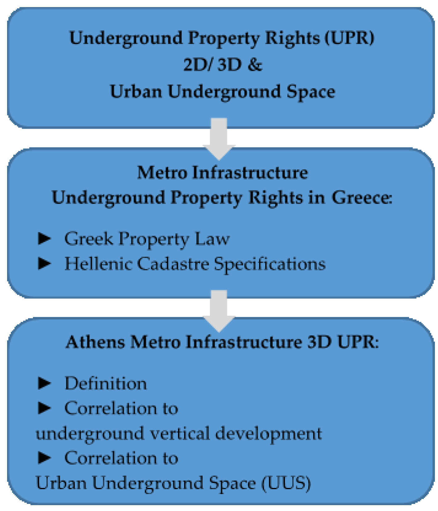
3. Metro Network Underground Property Rights in Greece: Current Status

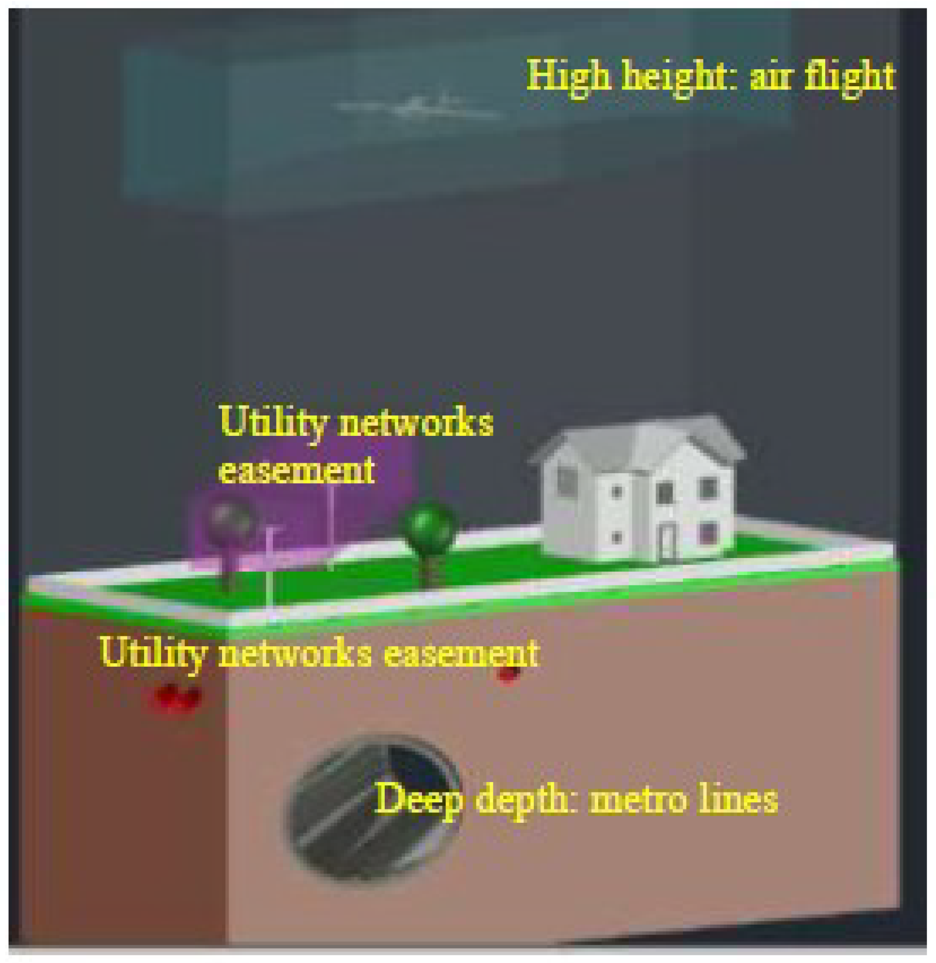
3.1. Underground Property Rights and Public Infrastructures in Greece

Greece’s Civil Code, enacted in 1946, defines as immovable thing: “the soil and its component” (Art. 948). Components of an immovable thing are defined as “things firmly connected to the ground, products connected to the ground, underground water and underground springs, seeds and, plants after plantation”, absolute property rights as “ownership, easement/ usufruct, pledge and mortgage”, whereas ownership rights “extents in the space above and below the immovable thing, unless the law provides otherwise, however the owner cannot forbid action of third party in that height or that depth, that by this forbiddance the owner has no interest” (Art, 954, 973 and 1001, respectively). Even though in Greece property rights are absolute, they could be restricted or limited for the public good and common interest projects, e.g., for security, urban and spatial planning, social economy, transportationation or by the State’s rights to exercise power for public utilities networks construction, easements for underground networks or over the ground electricity networks development that are subjected to compensation. Furthermore, 3D space in deep depths or in high heights, which the private property owner has no particular interest or profit to gain from its exploitation, can be used for common interest purposes, e.g., air flight passing and underground public transportationation network development, and this use is exempted from any compensation [54], Figure 2.
The 1973 “Mine Code” separates ownership above and below the ground for the underground resources exploitation, such as metals, marbles, construction stones, etc., that are public goods and that the State has the sole privilege for their exploitation [55].
In 1975, Greece’s new constitution acknowledges the importance of ownership rights on private properties and are constitutionally protected, but not at the expense of the general good. Subsequently, in the case of public interest projects that are constructed in private properties, e.g., utility networks, transportatio networks, community buildings or infrastructures development, expropriation is foreseen through the relevant compensation payment. Nonetheless, projects that are by law characterized as of obvious public interest projects and are developed in depth are exempted from any compensation payment. In those cases, the constitutional creator considers that the construction of obvious interest public projects underground infrastructures, e.g., metro tunnels, is in such depth that it does not affect or harm the usual exploitation of the uppermost property.

3.2. Cadastral Records and Underground Transportation Networks Property Rights

3.2.1. Hellenic Cadastre Spatial Records

Private property rights are legally and 2D technically described in legally binding deeds. They are valid only after the deeds’ transcription in land registries or their registration in Hellenic Cadastre operational Cadastral Offices after 2003 in respect to public faith safeguard on properties transactions. Public property rights or property rights of public infrastructures that affect private properties are legally and 2D technically described in official governmental or administrative acts, e.g., expropriations, published in the Official Government Gazette of the Hellenic Republic. Their transcription in land registries is not obligatory, contrary to their obligatory registration in operational Cadastral Offices. After completion of the ongoing cadastral survey for Hellenic Cadastre creation, Hellenic Cadastre will be the only official registration system on properties’ spatial definition and property rights, rules and restrictions.
The Hellenic Cadastre Cadastral Records are specified by official Ministerial Decision and are organized in the Hellenic Cadastre Information System that consists of the following:
  • The 2D Spatial/geometrical description of each distinct land parcel/plot, Hellenic Cadastre Spatial DB (HCSDB);
  • Legal description of property rights (in legal binding documents, e.g., deeds, official administrative acts published in the Official Government Gazette of the Hellenic Republic, etc.), legal restrictions on property rights, for each distinct land parcel/plot, Hellenic Cadastre Descriptive DB (HCDDDB).
Even though legal descriptions of properties, property rights and restrictions are three-dimensional, there is not any official, valid and obligatory regulation for their three-dimensional technical representation and visualization [27]. HCSDB is two-dimensional and integrated in the official Greek Coordinate System GGRS 87 (EPSG 2100), consisting of points, lines and closed polygons, whereas no circles or arcs are used for any geometrical representation. Spatial/geometric data for each distinct land parcel/plot are stored in the PST polygon feature layer. Objects/entities of common interest that are excluded from any transactions are defined as “Cadastral Special Areas—EK” and are classified either as natural, e.g., lakes, rivers, etc., or as technical constructions, e.g., roads, railway networks, etc. Special property rights and complex spatial relations between properties and property rights for mines and (a) property rights defined by the Ionian Civil Code, Cretan Civil Code and Customary Law of some Aegean Islands and (b) surface and other rights deriving from the precedent legislation on properties, the Byzantine–Roman Law [27], that are extended to more than one PST object and are stored in separate polygon feature layers, MRT and EIA. The exclusive use of a PST object part described in legal documents, e.g., vertical separation [27], passing through easement, etc., is stored in a VST polygon feature layer. Utility network easements, over or under the ground, are stored in EAS polygon feature layer. Spatial information regarding the boundaries of official administrative acts, published in the Official Government Gazette of the Hellenic Republic, are stored in DBOUND polygon feature layer. HCSDB schematic representation (by Dr. Perperidou) is presented in Figure 3.

3.2.2. Underground Transportation Networks Property Rights and Hellenic Cadastre

Even though there are specific topological rules and technical specifications for the registration in the two-dimensional HCSDB of utility networks easements or mines’ underground property rights, there are not any relevant provisions of underground transportation network infrastructure and tunnels. Underground transportation networks, and in particular, the metro network, are considered too complex and too specified cases of underground property rights so as to be incorporated and imported in the Hellenic Cadastre Information System. However, as the exploitation and development of UUS is gradually becoming a burning issue for Greek cities, underground property rights of transportation networks have to be technically and legally defined, not only in 2D but also in 3D as underground metro networks are developed in the most densely populated cities of Athens (4.5 M inhabitants) and Thessaloniki (1.2 M inhabitants). Additionally, 3D property rights of underground transportation network definition of facilitates their 2D representation in respect to the current topological rules and technical specifications of the Hellenic Cadastre Information System and to be imported and incorporated in the HCSDB.

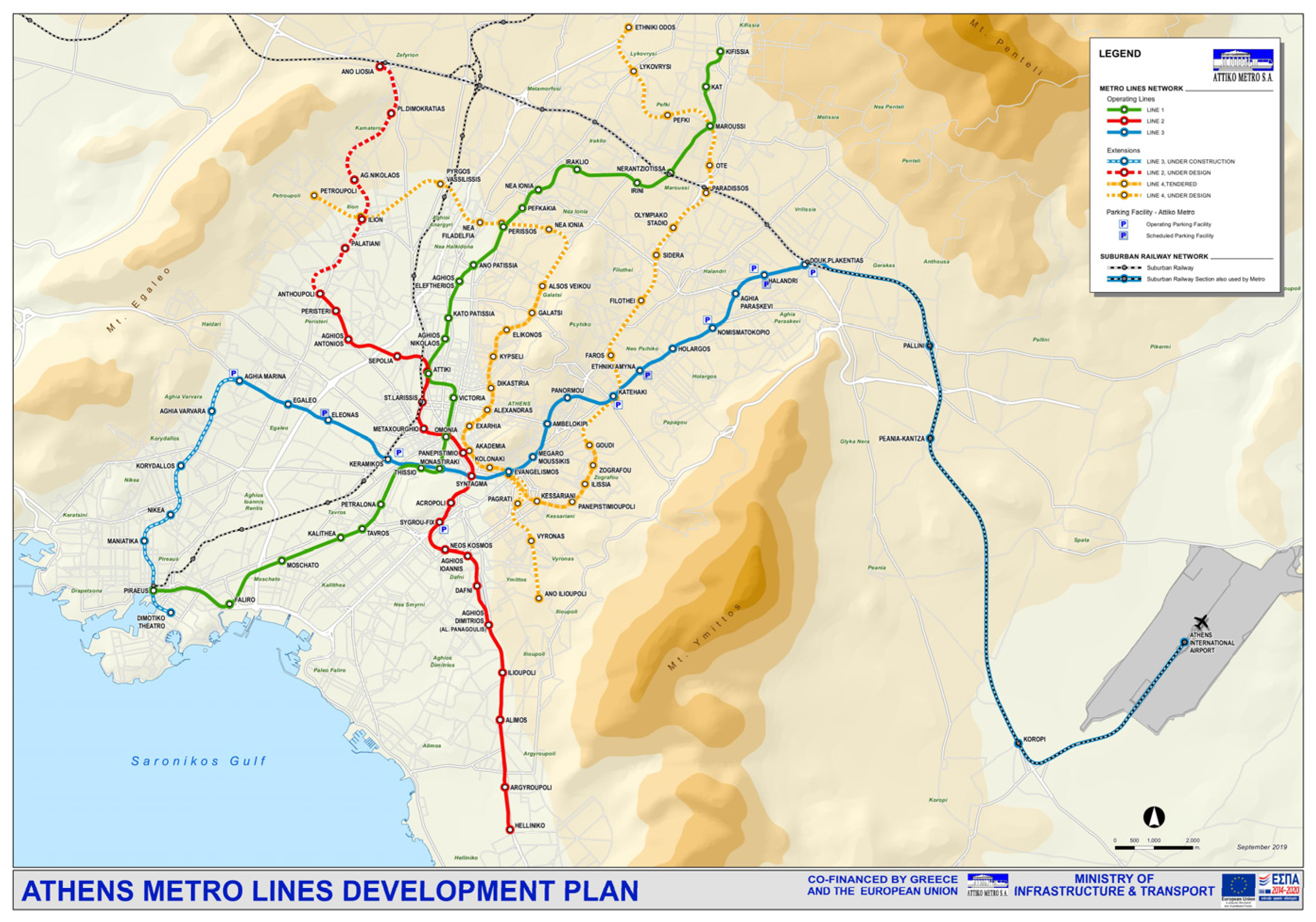
3.3. The Athens Metro

The first Rail Line in the Athens Greater Area was a surface line connecting Athens Center (Thisio) to Piraeus Center constructed between 1867 and 1869. By 1957, the line was expanded to the north to Kifissia suburb and went underground in the Monastiraki–Omonia–Victoria Section in the Athens city center (avg. depth 4–6 m, constructed in mid-1930). Today, Metro Line 1, Surface Rail or Green Line, is 25.6 km long and has 24 stations. In November 1992, the construction of the Metro Base Project began with the simultaneous construction of Metro Line 2 or Red Line and Metro Line 3 or Blue Line in the Greater Athens UUS. By January 2000, the partial operation of both lines started, and by June 2003, 13 km of tracks and 14 stations were in full operation. Currently, 59.7 km of Lines 2 and 3 tracks and 40 stations are in full operation, Line 3 expansion to Piraeus is under construction (6.5 km and 5 stations and will directly connect Athens International Airport to Piraeus Port), Line 2 expansion to the north is under study and the construction of the new Line 4, Yellow Line (12.8 km and 15 stations), has just begun [56], Figure 4.
The integration of Athens Metro in the UUS of a city with a centuries-old history (stromatographic archeological layers date back to 3500 BC) impacted the overall construction process and progress. Pre-construction on site archeological research revealed important archeological findings, wherefore the Metro tunnels are constructed in deeper depths, in some cases reaching 50 m depth, to minimize the impact to antiquities. Line 2’s average depth is 30 m, Line 3 17 m, while new Line 4 average depth is also 17 m. The actual vertical stations and tunnel infrastructures’ positioning is also affected from altitude, gradient, surface terrain and soil quality, Figure 5.

Athens Metro 3D Underground Property Rights Definition

Athens Metro is operated by Attiko Metro SA, a publicly owned company established by law in 1991 with a scope of “planning, construction, management, administration, exploitation, and development of Attica Region underground railway system” [57]. The Athens Metro is characterized by law as an of obvious public interest project. Thus, only near the ground-level properties might be potentially subjected to expropriation and only for the ground-level infrastructures. However, ground-level infrastructures are located mainly in publicly owned spaces, and there is not any legally binding document with a detailed description of space that is used for the metro infrastructures. All metro stations have surface entrances located on public spaces, parks, squares, wide pavements and pedestrian streets and are developed in multiple UUS levels, from three to six levels depending on the station. Metro stations’ UUS installations are subdivided into the mechanical areas level, the concourse level and the platform–tunnels level and are usually spatially developed and extended underneath public and, more rarely, under privately owned plots, Figure 6. On the concourse level, shopping or exhibition areas are available and rented by the Attiko Metro SA.
Metro tunnels are constructed in the lowest UUS level that the metro infrastructure occupies and are usually located underneath publicly owned, but in some cases underneath privately owned, plots. The tunnels have 3D customized geometrical characteristics according to the track type (single, double or triple) and the method that is chosen to construct the track. The average typical inner and external diameter for a double track is 8.5 to 9.5 m and 10 to 11 m, respectively. Three-dimensional underground property rights that are formed by the Athens Metro network development and infrastructures in Athens’ UUS, Figure 6, are categorized by the authors into the following:
  • Full ownership underneath areas expropriated according to PL Art. 1001 for metro development, owned by Attiko Metro SA;
  • Enhanced property rights of Attiko Metro SA for the use, exploitation, management and maintenance of the three-dimensional space formed by entrances construction;
  • Enhanced property rights of Attiko Metro SA for the use, exploitation, management and maintenance of the three-dimensional space formed by the main station infrastructures, developed in multiple levels;
  • Enhanced property rights of Attiko Metro SA for the use, exploitation, management and maintenance of the tunnels three-dimensional space;
  • The three-dimensional space underneath the station, owned by the surface plot owner;
  • The three-dimensional space from surface level to tunnels, owned by the surface plot owner as defined in PL Art. 1001;
The three-dimensional space underneath the tunnels, owned by the surface plot owner as defined in PL Art. 1001.
The 3D underground property rights for Piraeus Station, part of Athens Metro Line 3 extension, are defined, presented and analyzed in the following Section 4.

4. Defining 3D Underground Property Rights of Attiko Metro Piraeus Station

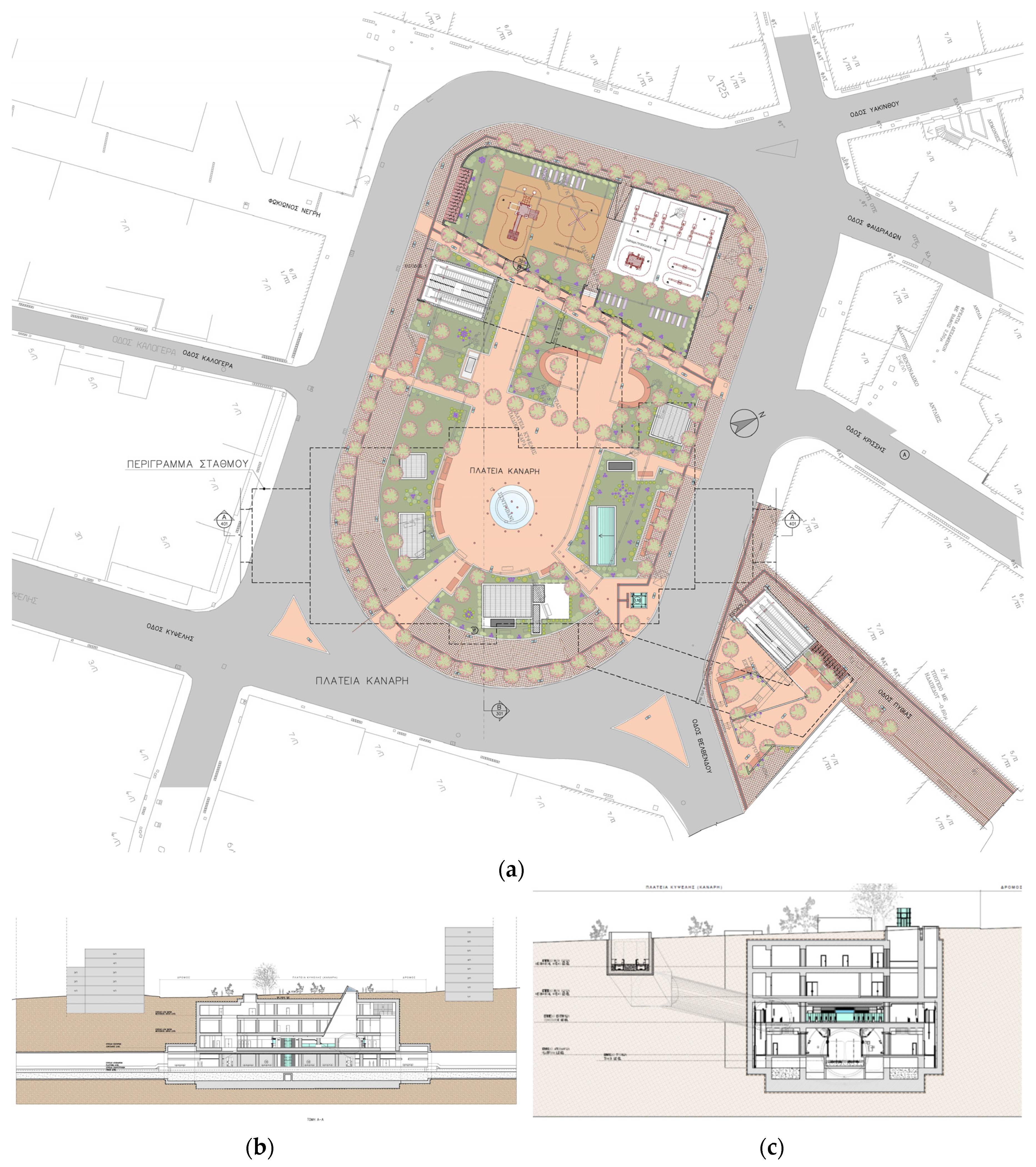
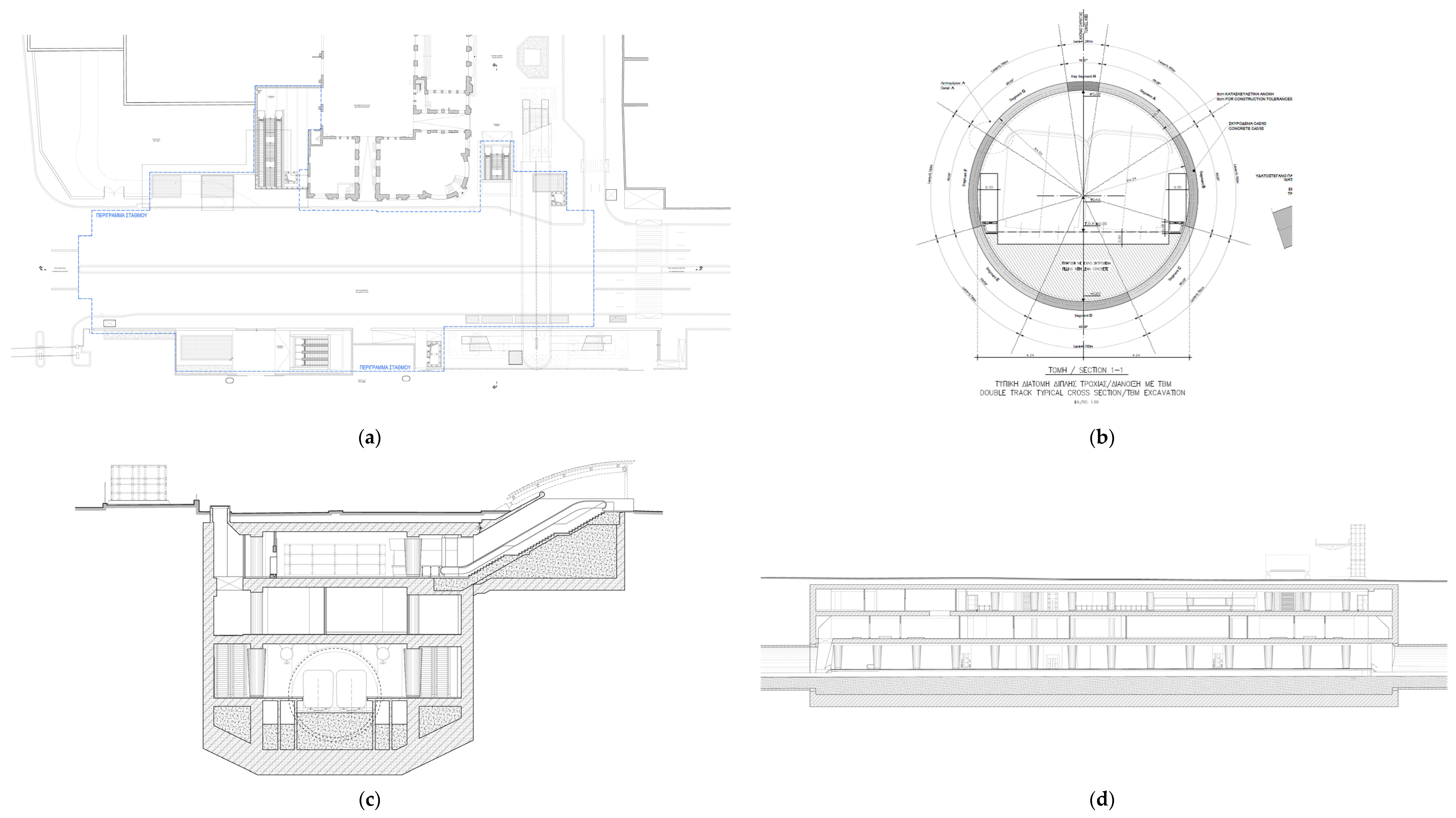
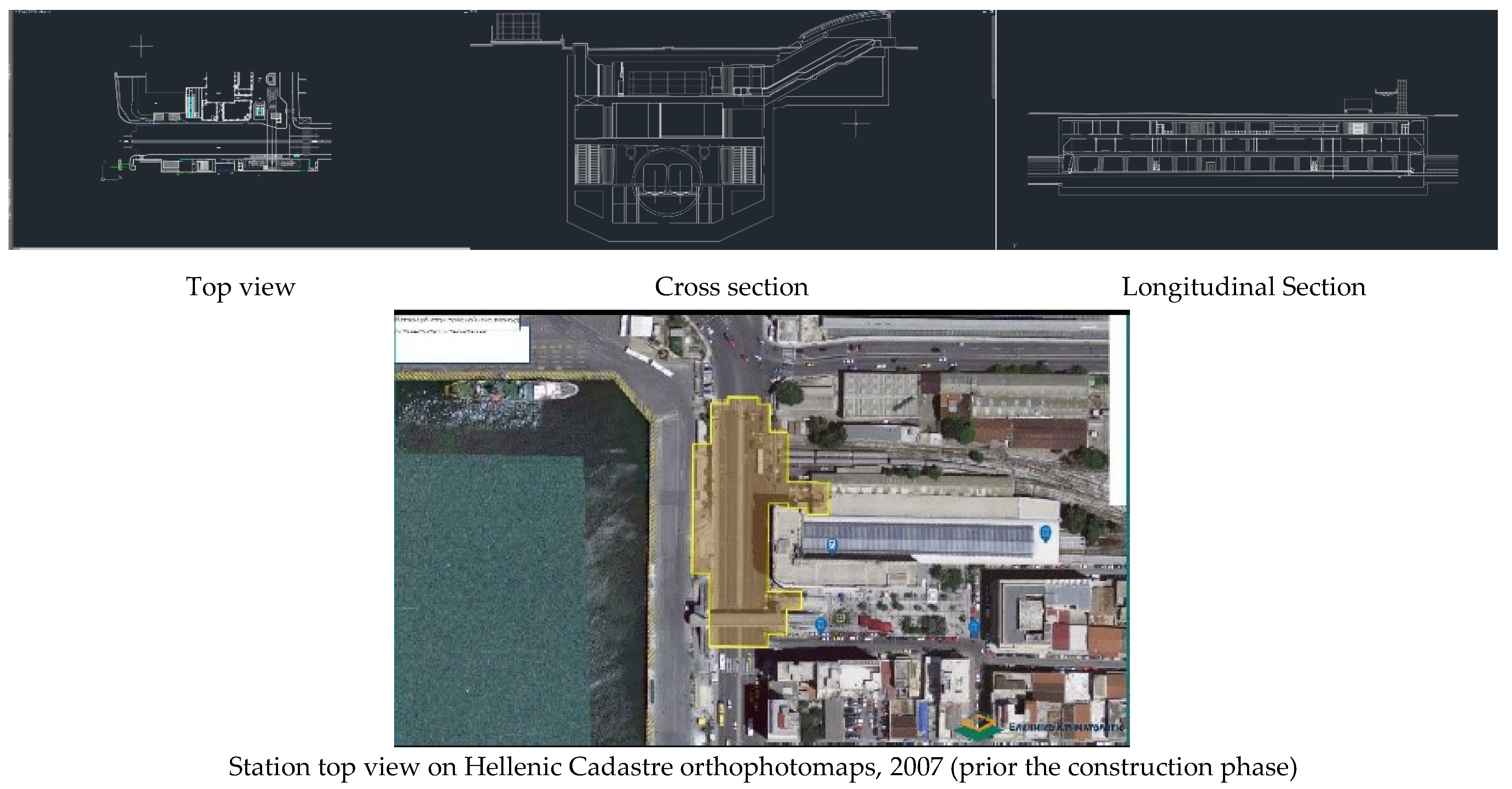
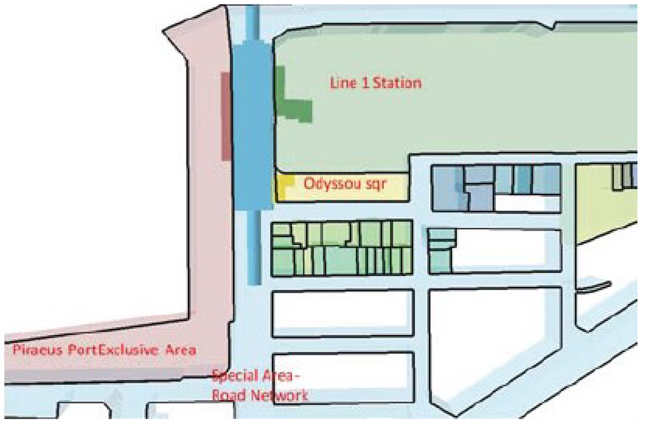
4.1. Piraeus Station 2D Model Construction

The Piraeus Station, part of Athens Metro Line 3 to Piraeus extension, is located at Piraeus Municipality, close to Piraeus Port Gates E5, E7 and E8. It intersects with the Suburban Railway, Surface Rail 1 and Piraeus tram line, forming the Piraeus Public Transportation Junction, Figure 7.
The station is located in front of the existing Surface Rail station and underneath (a) part of Akti Kallimasioti, the main circular route connecting all Piraeus Port gates, (b) the existing Surface Rail Station building, (c) the Piraeus Port Exclusive Zone and (d) Odyssou Square, Figure 8a. Its exact geometrical characteristics, top view and section drawings are retrieved from the Attiko Metro SA official web page (March 2020), Figure 8. The main station is developed in four underground levels, Figure 8b,c, and its three surface-level entrances are located at Port Exclusive Zone, Odyssou Sqr and inside the building of Surface Railway Station, Figure 8a. The station’s tracks are typical double tracks, Figure 8b.
Based on the official Attiko Metro SA drawings (top view and sections), Piraeus Station is geometrically and in detail represented in a cad environment. Non-essential details, such as internal stairwells and walls, are omitted. The 2D top view is georeferenced in the official Hellenic Coordinates System, GGRS 87, on the official 2007 Hellenic Cadastre orthophotomaps, Figure 9.

4.2. Pireaus Station 3D Model Construction

Based on the top view and sections’ 2D representations, the Piraeus Station 3D model was constructed, in cad environment as well. The length of the tracks’ tunnel was extended, to be easily visual recognizable. Basic 3D objects, such as cylinders, cuboids and prisms, are used for the 3D representation of Piraeus Station main structural features, e.g., entrances, main station, tracks tunnels and were extruded to the appropriate dimensions and scale. The station’s 3D model was created by the partial 3D features unification with use of the Boolean union process, Figure 10.

4.3. Piraeus Station 3D Underground Property Rights Definition

The Piraeus Station 3D model was georeferenced in GGRS 87, using as a base map the official 2007 Hellenic Cadastre orthophotomaps. In Piraeus Municipality Cadastral Office is in full operation since 2017, thus the official cadastral records on spatial and legal registration of the plots that Piraeus Station intersects in the UUS was feasible via the Hellenic Cadastre open access data. The definition of the 3D underground property rights, which are created by Piraeus Station construction in the UUS, Piraeus Station top view georeference in GGRS ’87 and correlated to the 2D official Hellenic Cadastre Spatial DB available in gov.gr (accessed on 1 September 2021) portal Figure 11. Comparing retrieved cadastral records to Piraeus Station top view, the parcels that the Station is developed underneath them were identified:
  • Metro Line 1 Station cadastral parcel, private property of Urban Rail SA;
  • Part of the cadastral parcel Special Area—road network, Akti Kallimatsioti, exempt from transactions, property of Piraeus Municipality;
  • Public Square Odyssou cadastral parcel, property of Piraeus Municipality;
  • Part of the Piraeus Port Exclusive Zone cadastral parcel, property of the Ministry of Finance.
To identify the 3D underground property rights, created by the construction and operation of the Piraeus Metro Station in Piraeus’ Municipality UUS, the 3D underground model of the Hellenic Cadastre cadastral parcels spatial records are created. In respect to Greek Property Law provisions, which foresees that ownership rights extends in the space above and below the immovable thing, the official cadastral parcel’s 3D underground model was created by extending their boundaries vertically and below level 0. The cadastral parcels 3D underground model is then correlated to Piraeus Station 3D model (georeferenced in GGRS ’87), Figure 12.
The three-dimensional features of the Piraeus Station 3D model intersect the official cadastral parcel’s 3D underground model in differentiated depths, forming various UUS 3D fragments and 3D property rights or limitations to property use and exploitation. To identify the various underground property rights and property use limitations, each station’s underground level 2D boundary is overlapped to the official 2D record of cadastral parcels. Vertically layering the UUS that is occupied by the 3D model of the Piraeus Metro Station facilitates the definition of the 2D spatial relation between the station and the official cadastral records. Thus, the 3D spatial relation correlated to their legal validation, in respect to the official provisions of Greek legislation on properties and the Hellenic Cadastre, is achieved on a preliminary level:
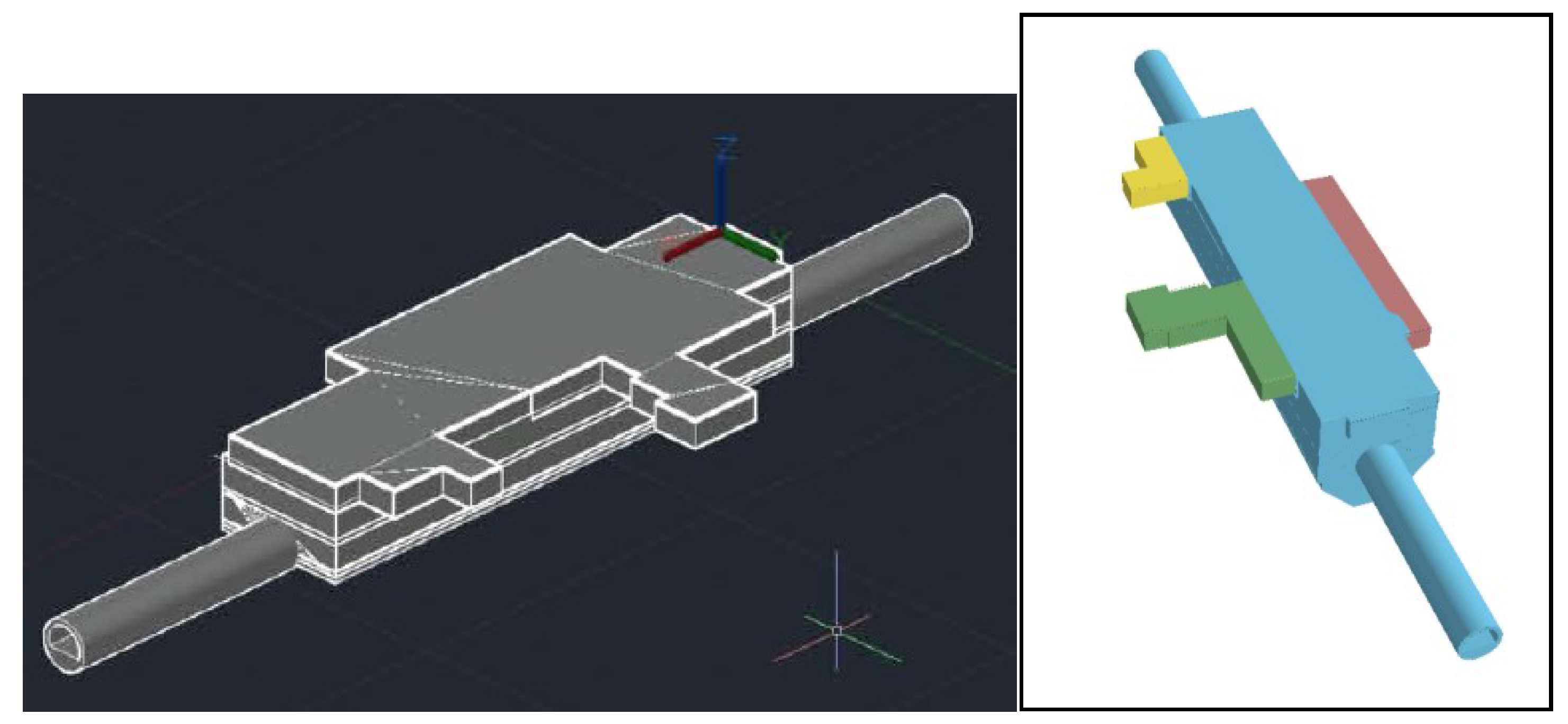
  • The UUS layers, formed by the intersection of the Piraeus Station 3D model intersection to the 3D model of the official parcels, are entrances, which are vertically developed from level 0 to level−1. They have the smaller 2D boundary, overlapping part of Line 1 Station, Odyssou Sqr and Akti Kallimatsioti and Piraeus Port Exclusive Zone cadastral parcels, property of Urban Rail SA, Piraeus Municipality and Ministry of Finance, respectively.
  • Entrances’ infrastructures, including staircases and escalators that divide the UUS into two 3D fragments: the under the ground level entrance’s 3D space and the below the entrance 3D space.
  • Mechanical area levels where all the necessary mechanical equipment for station’s operation is placed. The central ventilation system is vertically developed from level 0 to level 1 and within level 1, while the main mechanical machinery is in operation in level 1. The mechanical area 2D boundary overlaps a small part of the Line 1 Station and Piraeus Port Exclusive Zone cadastral parcels, between levels 0 and 1, while the main mechanical area in level 1 overlaps part of the Akti Kallimatsioti cadastral parcel.
  • The concourse and platform levels are developed underneath the main mechanical area level, in levels 2 and 3, respectively. Their 2D boundaries are completely identical to the 2D mechanical area boundary, overlapping only part of the Akti Kallimatsioti cadastral parcel.
  • Tunnel and platform foundations are developed in level 4. Foundations have a smaller 2D boundary, compared with the mechanical, concourse and platforms levels that overlaps only the Akti Kallimatsioti cadastral parcel.
  • Tunnel foundations outside the station overlap only the Akti Kallimatsioti cadastral parcel.
Summarizing, Piraeus Station levels 1, 2, 3 and 4 form a unified 3D underground object, which divides the UUS into two 3D fragments: the 3D space formed by levels 1 to 4 and the below level 4 3D space. Track tunnels, outside the station, divide UUS into three fragments: 3D space above tunnels, tunnels 3D space and below tunnels 3D space.
The 3D property rights or restrictions to property use and exploitation of the above analyzed 3D UUS layer fragments are presented in Table 1.

5. Discussion and Conclusions

The research presented herein is focused on identifying the 3D underground property rights of underground public transportation infrastructure, Piraeus Station, in Greece, according to Greek legislation on property rights, restrictions and limitations and the Hellenic Cadastre. The analysis is carried out for the Piraeus Metro Station. Piraeus Station is part of the Metro Line 3 expansion and is developed in Piraeus Municipality UUS close to Piraeus Port, Greece’s biggest port and one of Europe’s main ports. The underground Metro is operated by the publicly owned company Attiko Metro SA and is developed underneath land parcels registered to the Hellenic Cadastre and are legally and 2D spatially described in legally binding documents. The Piraeus Station and the overall Athens Metro Lines 2, 3 and 4 construction is based on Constitutional provision foreseeing that tunnels and underground infrastructure development of obvious public interest projects are exempt from any compensation to the uppermost property owner, as they are developed in deep depth that is considered as no obstruction to the uppermost property’s usual use. At the same time, management, use and exploitation of Athens metro network’s infrastructures and mainly of the metro stations that include underground exhibition and stores areas is by Law and in general granted a to Attiko Metro SA, without any in detail legal and technical specifications in respect to the uppermost property rights. There are no technical or in-detail legal specifications for track tunnels that also affect the uppermost property rights and property use or exploitation. Furthermore, enhanced property rights on the UUS, which, according to Greek Property Law, belongs to the surface properties owners, is granted to the Metro Company with no compensation to the surface property owner, exceeding Greek Property Law provisions.
To identify the 3D underground property rights of Piraeus Station, the 3D model of Piraeus Station and the 3D underground model of the official cadastral parcels are created. The intersection between those two 3D models revealed the differentiated 3D underground development of the Station’s distinct features, e.g., entrances, main station facilities, tracks tunnels and the fragmentation of the UUS. Simultaneously, the legal and technical description of UUS 3D fragments, derived from underground public transportation network development and operation, is also revealed. The in-detail legal and spatial identification of 3D underground property rights that are created from the metro network is based on layering the UUS in respect to the Station’s vertical development correlated to the official cadastral parcels, resulting in a 2.5 cadastral description that could be easily incorporated into the Hellenic Cadastre Information System. The proposed identification of the Athens metro underground property rights also describes in detail the enhanced propriety rights on the UUS 3D fragments, granted to Attiko Metro SA, which are not legally and technically defined in a legally binding document, e.g., an official administrative act, and are only depicted in 2D Attiko Metro SA drawings, Figure 6, published during public tender for the metro’s construction, exceeding again Greek Property Law provisions. Over the last few years, there has been a debate on whether the Attiko Metro SA has enhanced exploitation rights on concourse-level shopping and exhibition areas, without any remuneration or rent to the owner of the surface plot, which are usually municipalities or other public entities, without paying any compensation or rent. The legal and spatial identification of Athens Metro Station property rights could facilitate financial agreements between the Attiko Metro SA and the uppermost parcels owners, which are public entities.
The presented 3D underground property rights of the metro station highlight the disruption of the surface property usual use. It also highlights the deprivation from the municipal authorities to exercise their full ownership rights to construct vital municipal facilities, e.g., undergrounding road network, underground parking or storage facilities, etc.
Future research must be focused on metro-infrastructure-enhanced property rights with in-detail legal and technical definitions in a legally binding document. It should also focus on the incorporation of the 3D underground metro property rights to the current Hellenic Cadastre Information System and Spatial DB. In the next step, their integration to a 3D cadastral system could be examined. Research should also be focused on metro infrastructure and antiquates’ co-existence for new metro network developments in Greece. As the ongoing UUS exploitation continues and the underground development becomes more intensive, especially in major Greek cities, new challenges should be addressed. The protection of underground transportation networks infrastructures, mainly tunnels, from intense construction activities on the uppermost space, e.g., machinery vibrations and the depth of underground development, would gradually become a hot topic. Thus, those new 3D underground property rights must also be legally and technically defined.

Author Contributions

D.-G.P. was responsible for research conceptualization, methodology, 3D visualization and writing—review and editing; K.S. was responsible for data collection, data analysis, 2D and 3D data visualization and writing; A.C. was responsible for data collection, 2D and 3D visualization and writing. All authors have read and agreed to the published version of the manuscript.

Funding

This research received no funding.

Institutional Review Board Statement

Not applicable.

Informed Consent Statement

Not applicable.

Data Availability Statement

Not applicable.

Conflicts of Interest

The authors declare no conflict of interest.

References

  1. United Nations, Department of Economic and Social Affairs, Population Division. World Urbanization Prospects, The 2018 Revision; United Nations: New York, NY, USA, 2019; Available online: https://population.un.org/wup/Publications/Files/WUP2018-Report.pdf (accessed on 1 September 2021).
  2. Kim, S.; Heo, J. Development of 3D underground cadastral data model in Korea: Based on land administration domain model. Land Use Policy 2017, 60, 123–138. [Google Scholar] [CrossRef]
  3. Bobylev, N. Mainstreaming sustainable development into a city’s Master plan: A case of Urban Underground Space use. Land Use Policy 2009, 26, 1128–1137. [Google Scholar] [CrossRef]
  4. Bartel, S.; Janssen, G. Underground spatial planning–Perspectives and current research in Germany. Tunn. Undergr. Space Technol. 2016, 55, 112–117. [Google Scholar] [CrossRef]
  5. Vähäaho, I. An introduction to the development for urban underground space in Helsinki. Tunn. Undergr. Space Technol. 2016, 55, 324–328. [Google Scholar] [CrossRef]
  6. Yuan, H.; He, Y.; Wu, Y. A comparative study on urban underground space planning system between China and Japan. Sustain. Cities Soc. 2019, 48, 101541. [Google Scholar] [CrossRef]
  7. Thewes, M.; Godard, J.-P.; Kocsonya, P.; Nisji, J.; Arends, G.; Broere, W.; Elioff, A.; Parker, H.; Sterling, L.R. Report on Underground Solutions for Urban Problems; ITA Report, No. 11; ITA-AITES: Châtelaine, Switzerland, 2012. [Google Scholar]
  8. Pasqual, J.; Riera, P. Underground land values. Land Use Policy 2005, 22, 322–330. [Google Scholar] [CrossRef]
  9. Mavrikos, A.; Kaliampakos, D. An integrated methodology for estimating the value of underground space. Tunn. Undergr. Space Technol. 2021, 109, 103770. [Google Scholar] [CrossRef]
  10. Peng, J.; Peng, F.-L.; Yabuki, N.; Fukuda, T. Factors in the development of urban underground space surrounding metro stations: A case study of Osaka, Japan. Tunn. Undergr. Space Technol. 2019, 91, 103009. [Google Scholar] [CrossRef]
  11. Barker, M. Legal and administrative issues in underground space use: A preliminary survey of ITA member nations. Tunn. Undergr. Space Technol. 1991, 6, 191–209. [Google Scholar] [CrossRef]
  12. Kaliampakos, D.; Benardos, A. Underground space development: Setting modern strategies. WIT Trans. Built Environ. 2008, 102, 1–10. [Google Scholar]
  13. Xu, Q. Overview of Underground Space Utilization and Standardization Suggestions. In Data Processing Techniques and Applications for Cyber-Physical Systems (dpta 2019); Springer Nature: Berlin/Heidelberg, Germany, 2020; pp. 195–204. [Google Scholar]
  14. Xie, H.; Zhang, Y.; Chen, Y.; Peng, Q.; Liao, Z.; Zhu, J. A case study of development and utilization of urban underground space in Shenzhen and the Guangdong-Hong Kong-Macao Greater Bay Area. Tunn. Undergr. Space Technol. 2021, 107, 103651. [Google Scholar] [CrossRef]
  15. Admiraal, H.; Cornaro, A. Future cities, resilient cities—The role of underground space in achieving urban resilience. Undergr. Space 2020, 5, 223–228. [Google Scholar] [CrossRef]
  16. Bobylev, N. Underground space as an urban indicator: Measuring use of subsurface. Tunn. Undergr. Space Technol. 2016, 55, 40–51. [Google Scholar] [CrossRef] [Green Version]
  17. Cui, J.; Broere, W.; Lin, D. Underground space utilisation for urban renewal. Tunn. Undergr. Space Technol. 2021, 108, 103726. [Google Scholar] [CrossRef]
  18. Bobylev, N. Transitions to a high density urban underground space. Procedia Eng. 2016, 165, 184–192. [Google Scholar] [CrossRef]
  19. Zaini, F.; Hussin, K.; Raid, M.M. Legal considerations for urban underground space development in Malaysia. Undergr. Space 2017, 2, 234–245. [Google Scholar] [CrossRef]
  20. van Erp, S. A numerus quasi-clausus of property rights as a constitutive element of a future European property law? Electron. J. Comp. Law 2003, 7, 1–12. [Google Scholar]
  21. Moerkerke, J. Property Registration: Challenges for the Future; 7th Annual Publication; European Land Registry Association: Athens, Greece, 2017; pp. 69–86. [Google Scholar]
  22. Perperidou, D. Spatial and Descriptive Documentation of Land Parcels in Hellenic Cadastre: The Case of Mati and Kokkino Limanaki Areas. In Proceedings of the FIG Working Week 2020, Amsterdam, The Netherlands, 14 May 2020; Available online: https://www.fig.net/resources/proceedings/fig_proceedings/fig2020/papers/ts03h/TS03H_perperidou_10387.pdf (accessed on 4 March 2021).
  23. Seifert, M. Legal, Law, Cadastre. In Springer Handbook of Geographic Information; Springer Science & Business Media: Berlin/Heidelberg, Germany, 2011; pp. 379–403. [Google Scholar]
  24. Silviana, A.; Utama, Y.J.; Ismail, N. Preferability of the positive-characterized negative publication in cadastral registration in Indonesia. J. Crit. Rev. 2020, 7, 979–982. [Google Scholar]
  25. Frank, A.U. An Object-Oriented, Formal Approach to the Design of Cadastral Systems. In Proceedings of the 7th International Symposium on Spatial Data Handling (SDH), Delft, The Netherlands, 12–16 August 1996; Volume 96, p. 5A. [Google Scholar]
  26. Degel, B. Reliability Aspects of the German Cadastre. Z. Geodäsie Geoinf. Landmanag 2019, 6, 386–390. [Google Scholar]
  27. Perperidou, D.-G.; Moschopoulos, G.; Sigizis, K.; Ampatzidis, D. Greece’s Laws on Properties and the Third Dimension: A Comparative Analysis. In Proceedings of the FIG e-Working Week 2021, Amsterdam, The Netherlands, 21–25 June 2021; p. 13. Available online: https://fig.net/resources/proceedings/fig_proceedings/fig2021/papers/ws_03.3/WS_03.3_perperidou_moschopoulos_et_al_11186.pdf (accessed on 1 September 2020).
  28. Femenia-Ribera, C.; Mora-Navarro, G. Cadastre-Land Registry Coordination in Spain: Application of Law 13/2015 and Its Effects. 2018. Available online: https://www.preprints.org/manuscript/201803.0232/v1 (accessed on 1 September 2020).
  29. Stoter, J.E. 3D Cadastre. Ph.D. Thesis, Delft University of Technology, Delft, The Netherlands, 2004. [Google Scholar]
  30. van Oosterom, P.; Erba, D.A.; Aien, A.; Grant, D.; Kalantari, M.; Karki, S.; Shojaei, D.; Thompson, R.; Muggenhuber, G.; Navratil, G. Best Practices 3D Cadastres: Extended Version; International Federation of Surveyors: Copenhagen, Denmark, 2018. [Google Scholar]
  31. Paasch, J.M.; Paulsson, J. 3D Property Research from a Legal Perspective Revisited. Land 2021, 10, 494. [Google Scholar] [CrossRef]
  32. Bélanger, P. Altitudes of urbanization. Tunn. Undergr. Space Technol. 2016, 100, 5–7. [Google Scholar] [CrossRef]
  33. Volchko, Y.; Norrman, J.; Ericsson, L.O.; Nilsson, K.L.; Markstedt, A.; Öberg, M.; Mossmark, F.; Bobylev, N.; Tengborg, P. Subsurface planning: Towards a common understanding of the subsurface as a multifunctional resource. Land Use Policy 2020, 90, 104316. [Google Scholar] [CrossRef]
  34. Zhang, Z.; Tang, W.; Gong, J. Property rights of urban underground space in China: A public good perspective. Land Use Policy 2017, 65, 224–237. [Google Scholar] [CrossRef]
  35. Zhang, Z.; Paulsson, J.; Gong, J.; Huan, J. Legal Framework of Urban Underground Space in China. Sustainability 2020, 12, 8297. [Google Scholar] [CrossRef]
  36. Karabin, M.; Kitsakis, D.; Koeva, M.; Navratil, G.; Paasch, J.M.; Paulsson, J.; Vučić, N.; Janečka, K.; Lisec, A. Layer approach to ownership in 3D cadastre in the case of underground tunnels. Land Use Policy 2020, 98, 104464. [Google Scholar] [CrossRef]
  37. Peng, F.-L.; Qiao, Y.-K.; Zhao, J.-W.; Liu, K.; Li, J.-C. Planning and implementation of underground space in Chinese central business district (CBD): A case of Shanghai Hongqiao CBD. Tunn. Undergr. Space Technol. 2020, 95, 103176. [Google Scholar] [CrossRef]
  38. Derrible, S.; Kennedy, C. The complexity and robustness of metro networks. Phys. A Stat. Mech. Appl. 2010, 389, 3678–3691. [Google Scholar] [CrossRef]
  39. Li, Z. Transportationation Asset Management: Methodology and Applications; CRC Press: Boca Raton, FL, USA, 2018. [Google Scholar]
  40. Darroch, N.; Beecroft, M.; Nelson, J.D. A qualitative analysis of the interfaces between urban underground metro infrastructure and its environment in London. Tunn. Undergr. Space Technol. 2021, 114, 103930. [Google Scholar] [CrossRef]
  41. Pouliot, J. 3D Cadastre: With or Without Subsurface Utility Network. In Proceedings of the 5th International FIG Workshop on 3D Cadastres, Athens, Greece, 18–20 October 2016. [Google Scholar]
  42. den Duijn, X. A 3D Data Modeling Approach for Integrated Management of below and above Ground Utility Network Features. Master’s Thesis, Delft University of Technology, Delft, The Netherlands, 2018. [Google Scholar]
  43. van Son, R.; Jaw, S.W.; Yan, J.; Soon, V.K.H.; Kiah, R.L.W.; Ni, S.T.S.; Schrotter, G. A framework for reliable three-dimensional underground utility mapping for urban planning. Int. Arch. Photogramm. Remote. Sens. Spat. Inf. Sci. 2018, 42, 209–214. [Google Scholar] [CrossRef] [Green Version]
  44. Qiao, Y.-K.; Peng, F.-L.; Wang, Y. Valuing external benefits of underground rail transit in monetary terms: A practical method applied to Changzhou City. Tunn. Undergr. Space Technol. 2019, 83, 91–98. [Google Scholar] [CrossRef]
  45. Dong, Y.-H.; Peng, F.-L.; Guo, T.-F. Quantitative assessment method on urban vitality of metro-led underground space based on multi-source data: A case study of Shanghai Inner Ring area. Tunn. Undergr. Space Technol. 2021, 116, 104108. [Google Scholar] [CrossRef]
  46. Davis, V.O. Impact of Metrorail Stations in Washington, DC on Land Use and Development: Shady Grove Metro Station Case Study. In Transportationation Land Use, Planning, and Air Quality; American Society of Civil Engineers: Reston, VA, USA, 2008; pp. 118–123. [Google Scholar]
  47. Pagliara, F.; Russo, L.; Aria, M. Measuring retailers’ perceptions of new metro stations inauguration. Land Use Policy 2021, 104, 105349. [Google Scholar] [CrossRef]
  48. Hu, H.; Zhang, Y.; He, N. Research on the New Development Mode of Metro TOD Based on Tourism Economy—Taking Shijiu Lake Scenic Area in Nanjing as an Example. In IOP Conference Series: Earth and Environmental Science; IOP Publishing: Bristol UK, 2021; Volume 693, p. 012052. [Google Scholar]
  49. Delmastro, C.; Lavagno, E.; Schranz, L. Underground urbanism: Master plans and sectorial plans. Tunn. Undergr. Space Technol. 2016, 55, 103–111. [Google Scholar] [CrossRef]
  50. Li, H.; Li, X.; Soh, C.K. An integrated strategy for sustainable development of the urban underground: From strategic, economic and societal aspects. Tunn. Undergr. Space Technol. 2016, 55, 67–82. [Google Scholar] [CrossRef]
  51. Hámor-Vidó, M.; Hámor, T.; Czirok, L. Underground space, the legal governance of a critical resource in circular economy. Resour. Policy 2021, 73, 102171. [Google Scholar] [CrossRef]
  52. Besner, J. Underground space needs an interdisciplinary approach. Tunn. Undergr. Space Technol. 2016, 55, 224–228. [Google Scholar] [CrossRef]
  53. Saeidian, B.; Rajabifard, A.; Atazadeh, B.; Kalantari, M. Underground Land Administration from 2D to 3D: Critical Challenges and Future Research Directions. Land 2021, 10, 1101. [Google Scholar] [CrossRef]
  54. Balis, G. Property Law, According to the Civil Code; Typois Pyrsou: Athens, Greece, 1951. [Google Scholar]
  55. Mine Code; Official Government Gazette of the Hellenic Republic: Athens, Greece, 1973; Available online: www.et.gr (accessed on 1 September 2020).
  56. Attiko Metro. Available online: https://www.ametro.gr/ (accessed on 10 September 2021).
  57. Law 1955 on Attiko Metro; Official Government Gazette of the Hellenic Republic: Athens, Greece, 1991; Available online: www.et.gr (accessed on 1 September 2020).
Figure 1. Methodology.
Sustainability 13 13162 g001
Figure 2. Three-dimensional property rights and restrictions according to Greek PL (source: Perperidou et al. 2021). copyright is in the 27th element of the literature.
Sustainability 13 13162 g002
Figure 3. Hellenic Cadastre Spatial DB schematic representation (Dr. Perperdiou illustration based on HC Technical Specifications, 2016 cadastral survey public tender).
Sustainability 13 13162 g003
Figure 4. Athens Metro Lines existing lines and development plan (Source: Attiko Metro, web page, 2021).
Sustainability 13 13162 g004
Figure 5. Profile alignment of Athens Metro Line 4 (Source: Attiko Metro, web page, 2021).
Sustainability 13 13162 g005
Figure 6. Athens Metro Line 4 Kypseli Station, Athens Municipality: (a) street level top view, (b) cross section, (c) longitudinal section (Source: Source: Attiko Metro web page, 2021).
Sustainability 13 13162 g006
Figure 7. Piraeus public transportation junction.
Sustainability 13 13162 g007
Figure 8. Piraeus Metro Line 3 Station top view and sections (source: Attiko Metro SA web page, 2020): (a) top view, (b) double tracks section, (c) cross section, (d) longitudinal section.
Sustainability 13 13162 g008
Figure 9. Piraeus Station 2D representation top view and sections in cad environment and Hellenic Cadastre orthophotomaps (illustration K. Sigizis. and A. Hotza).
Sustainability 13 13162 g009
Figure 10. Piraeus 3D model, blue: main station, green: entrance from Metro Line 1 Station, yellow: entrance from Odyssou sqr, red: entrance from Piraeus Port Exclusive Zone (illustration by Dr. Perperidou.).
Sustainability 13 13162 g010
Figure 11. Piraeus Station top view and current cadastral (illustration by the authors).
Sustainability 13 13162 g011
Figure 12. Three-dimensional representation of Piraeus Metro Station and cadastral parcels, (a) surface 3D view, (b) underground 3D view (illustration by Dr. Perperidou & K. Sigizis).
Sustainability 13 13162 g012
Table 1. UUS and 3D underground property rights of Piraeus Station.
Piraeus Station
UUS 3D Feature
2D Cadastral Parcel
Owner
Type of Right
for Metro Infrastructure
Type of Right for
Cadastral Parcel Owner
3D space entrance
level 0 to 1Urban Rail SA, Municipality of Piraeus, Ministry of FinanceEnhanced Ownership rights on use, exploitation, development, maintenance/equivalent to utilities network easement/
possible subjected to compensation
Bare ownership
3D space below entranceUrban Rail SA, Municipality of Piraeus, Ministry of Finance NoneFull owner ship
3D space main station
levels 0 to 1/
mechanical area
constructions
Urban Rail SA, Municipality of Piraeus, Ministry of Finance Enhanced Ownership rights on use, exploitation, development, maintenance/
equivalent to easement
Bare ownership
levels 1 to 4Municipality of PiraeusEnhanced Ownership rights on use, exploitation, development, maintenance/
equivalent to easement
Bare ownership
3D space below level 4Municipality of PiraeusNoneFull owner ship
3D space tunnels
Level 0 to 3 Piraeus MunicipalityNone/possible future further fragmentation for tunnels structural protection from nuisance during construction activities, e.g., vibrations.Full owner ship
Level 3 to 4Municipality of PiraeusEnhanced Ownership rights on use
exploitation, development, maintenance/
equivalent to easement
Bare ownership
3D space below tunnelsMunicipality of PiraeusNoneFull owner ship
Publisher’s Note: MDPI stays neutral with regard to jurisdictional claims in published maps and institutional affiliations.

