
Can Current Earth Observation Technologies Provide Useful Information on Soil Organic Carbon Stocks for Environmental Land Management Policy?

 ,
, 
 ,
, 
Abstract
:1. Introduction
2. Materials and Methods
2.1. EO for SOC—Literature Acquisition and Evaluation
2.2. Expert Interviews
2.3. Cost-Accuracy Analysis
3. Results
3.1. Literature Analysis of EO-Based Approaches for SOC Measurement
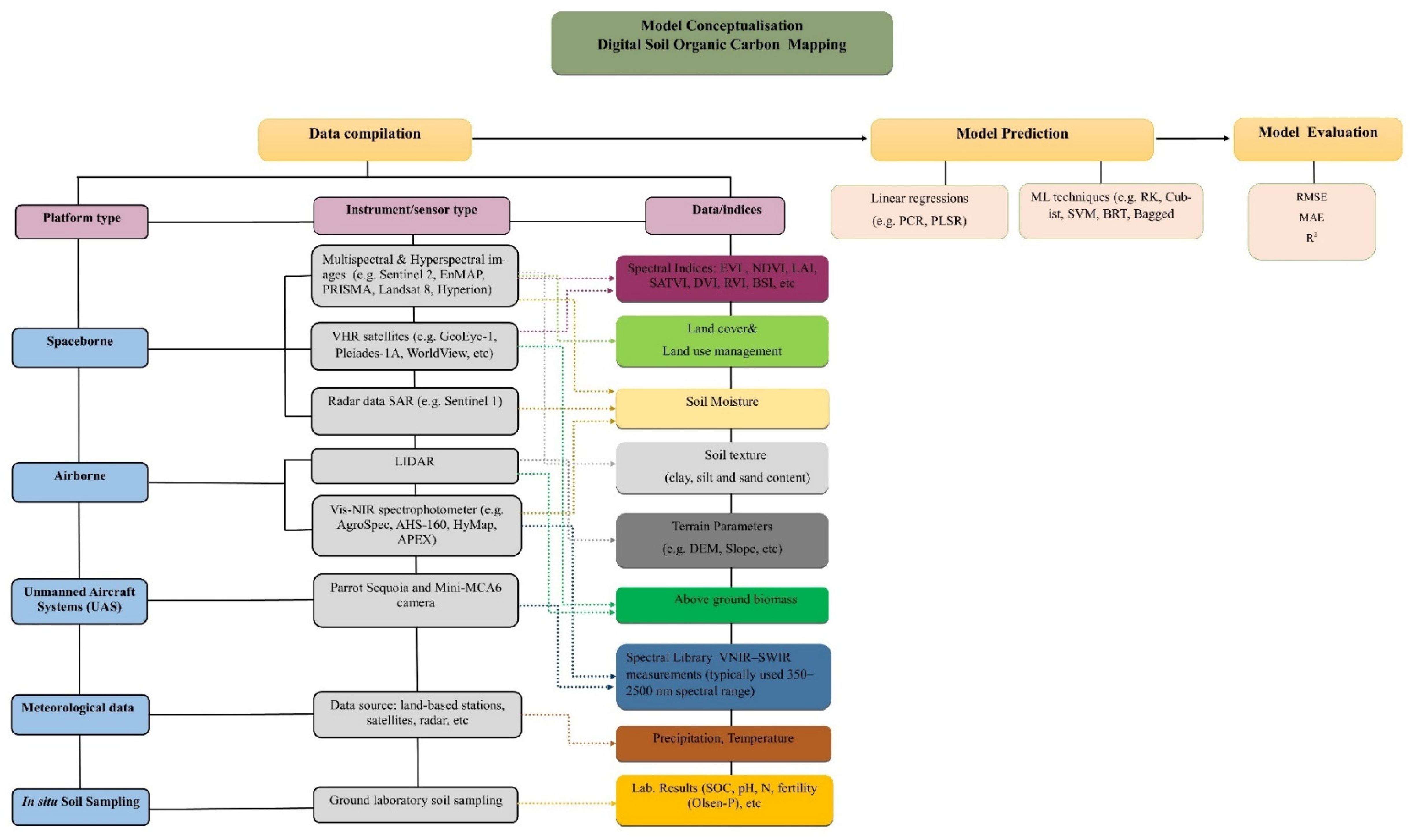
3.1.1. Selection of Environmental Variables (Covariates) and Data Compilation
- Spectral indices derived from multispectral images such as Normalized Difference Vegetation Index (NDVI) [52], Enhanced Vegetation Index (EVI) [50], Soil Adjusted Total Vegetation Index (SATVI) [53], Brightness Index (BI) and Greenness Index (GI) [52], Vegetation Temperature Condition Index (VTCI) [52,54,55], Ratio Vegetation Index (RVI) (also for aboveground biomass estimation) [56], soil moisture [57], and soil texture [58];
- VHR satellite data and LiDAR, which is used to estimate above-ground biomass by assessing tree composition and height, both of which are useful proxies in predicting SOC stock [60];
- Data derived from multispectral sensors mounted on UAS, for example, by combining hyperspectral and high-resolution images of bare soil to obtain libraries of soil spectral reflectance for training machine learning techniques [49,61,62]. The model development also relies on traditional laboratory SOC measurements taken from samples collected in the field.
3.1.2. SOC Model
3.1.3. Model Evaluation
3.1.4. Summary of Methods
3.2. Expert Interviews
3.2.1. Theme 1: SOC/SOM within Agricultural Policy
3.2.2. Theme 2: EO for SOC and Its Level of Accuracy
3.2.3. Theme 3: Criteria for the Design of an MRV Framework for SOC
3.3. Cost-Accuracy Analysis
4. Discussion
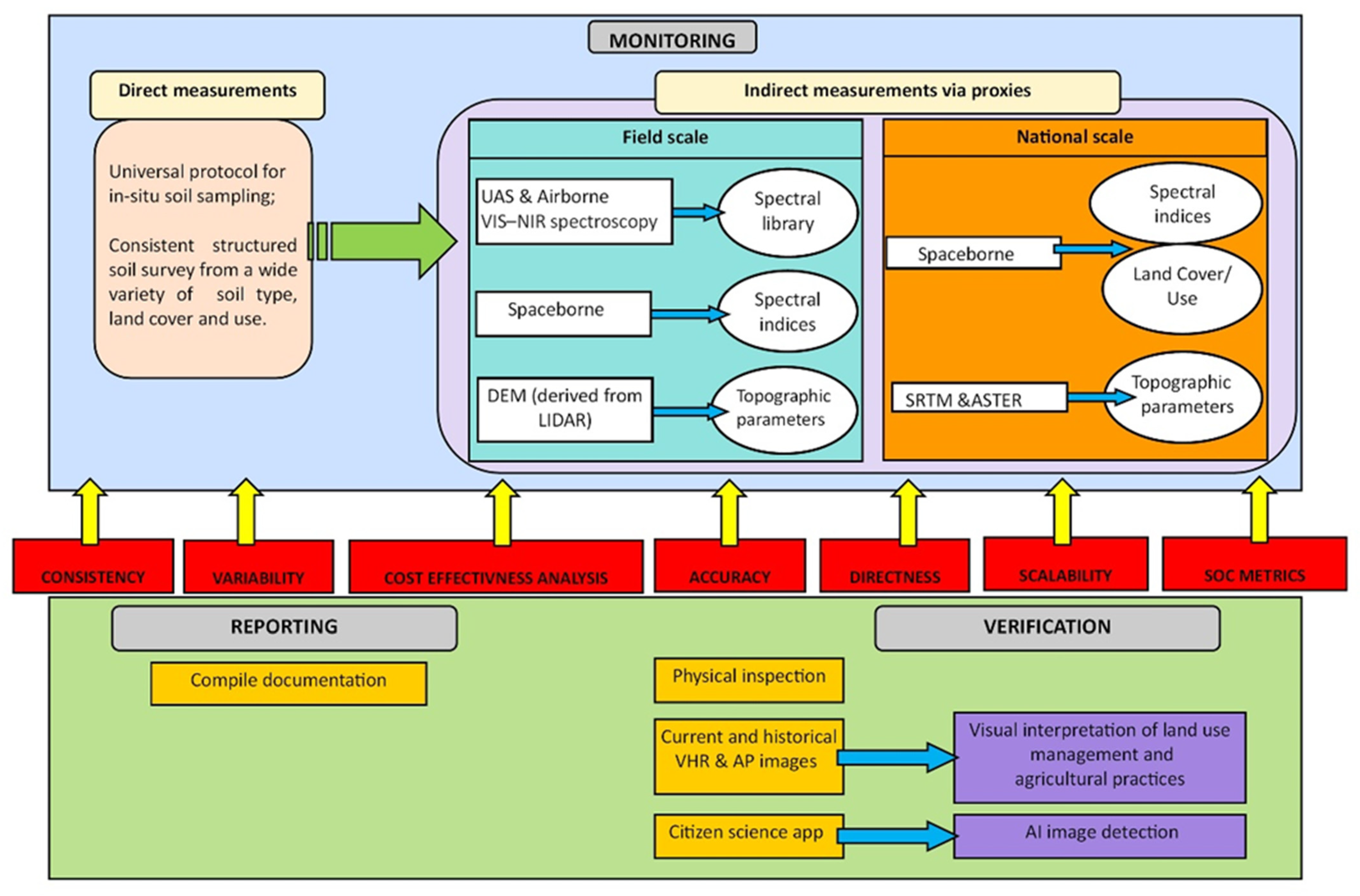
- Monitoring—Direct measurements through in situ soil sampling using a universal protocol and indirect measurements via proxies (e.g., UAS, airborne and satellite data). The measurements and estimation should determine the state and change of the SOC level. Key criteria to be considered should be consistency in soil sampling, high variability of the SOC, cost accuracy analysis, clear SOC metrics (that would be nationally/internationally recognised), and the scalability of the approach.
- Reporting—Documents to inform all relevant stakeholders, including information on the methodologies, assumptions, and data.
- Verification—A series of procedures for checking and verifying the quality of monitoring and reporting. Verification could be achieved through physical field inspections, independent remote sensing analysis, and/or smartphone apps (similar to BGS MySoil app [77] or Soilmentor [78]). Evidence suggests that there is a large potential for increasing carbon storage in agricultural soils through changes in land use management and agricultural practices. The importance of this SOC storage and the potential for land managers to receive incentives for its enhancement suggests that VHR satellite data could well provide an economically viable, cost-effective tool for the verification stage. According to the UK National Audit Office (2019), the Rural Payments Agency (RPA), which pays subsidies to farmers (part of the Common Agricultural Policy-Basic Payments scheme), has increased remote inspections by 75% using satellite data with an operational cost saving of up to GBP 2.1 million per year [79]. Similar evidence has been shown in Ireland, which suggests that the average cost of a physical inspection in 2010 was EUR 1800 compared with EUR 60–EUR 70 for a remote sensing check [80].
5. Conclusions
- Satellite- and UAS-derived data provide unique capabilities for addressing current challenges in the MRV of SOC, at all scales;
- Well-established training datasets along with advances in machine learning are likely to increase the overall accuracy of SOC prediction models, especially when complemented by soil spectral libraries based on soil sampling;
- A more robust analysis of uncertainties associated with both EO derived data and in-situ measurements are required;
- Integration of UASs should be considered at farm scale as being the most cost-accurate approach, whereas free satellite data would be more appropriate to be used at the national scale but with lower accuracy;
- We propose a framework for the MRV of SOC, which includes direct measurements via a combination of in situ soil sampling and indirect measurements through EO.
Author Contributions
Funding
Institutional Review Board Statement
Informed Consent Statement
Data Availability Statement
Acknowledgments
Conflicts of Interest
References
- FAO. Measuring and Modelling Soil Carbon Stocks and Stock Changes in Livestock Production Systems—Guidelines for Assessment. Version 1—Advanced Copy; FAO: Rome, Italy, 2019; p. 152. [Google Scholar]
- Jobbagy, E.G.; Jackson, R.B. The Vertical Distribution of Soil Organic Carbon and Its Relation to Climate and Vegetation. Ecol. Appl. 2000, 10, 423–436. [Google Scholar] [CrossRef]
- Batjes, N.H. Total carbon and nitrogen in the soils of the world. Eur. J. Soil Sci. 1996, 47, 151–163. [Google Scholar] [CrossRef]
- Lal, R. Soil Carbon Sequestration Impacts on Global Climate Change and Food Security. Science 2004, 304, 1623–1627. [Google Scholar] [CrossRef] [PubMed] [Green Version]
- ITPS. Status of the World’s Soil Resources (SWSR)—Main Report; Food and Agriculture Organization of the United Nations and Intergovernmental Technical Panel on Soils: Rome, Italy, 2015. [Google Scholar]
- House of Commons Environmental Audit Committee. Soil Health: Government Response to the Committee’s First Report of Session 2016–2017. Available online: http://www.publications.parliament.uk/pa/cm201617/cmselect/cmenvaud/650/650.pdf (accessed on 12 August 2021).
- GSOCMap. Available online: http://54.229.242.119/GSOCmap/ (accessed on 13 August 2021).
- Lal, R.; Bouma, J.; Brevik, E.; Dawson, L.; Field, D.J.; Glaser, B.; Hatano, R.; Hartemink, A.E.; Kosaki, T.; Lascelles, B.; et al. Soils and sustainable development goals of the United Nations: An International Union of Soil Sciences perspective. Geoderma Reg. 2021, 25, e00398. [Google Scholar] [CrossRef]
- Government, H. A Green Future: Our 25 Year Plan to Improve the Environment. Available online: https://assets.publishing.service.gov.uk/government/uploads/system/uploads/attachment_data/file/693158/25-year-environment-plan.pdf (accessed on 12 August 2021).
- Smith, P.; Chapman, S.J.; Scott, W.A.; Black, H.I.J.; Wattenbach, M.; Milne, R.; Campbell, C.D.; Lilly, A.; Ostle, N.; Levy, P.E.; et al. Climate change cannot be entirely responsible for soil carbon loss observed in England and Wales, 1978–2003. Glob. Chang. Biol. 2007, 13, 2605–2609. [Google Scholar] [CrossRef]
- Lal, R. Digging deeper: A holistic perspective of factors affecting soil organic carbon sequestration in agroecosystems. Glob. Chang. Biol. 2018, 24, 3285–3301. [Google Scholar] [CrossRef] [PubMed]
- Sykes, A.J.; Macleod, M.; Eory, V.; Rees, R.M.; Payen, F.; Myrgiotis, V.; Williams, M.; Sohi, S.; Hillier, J.; Moran, D.; et al. Characterising the biophysical, economic and social impacts of soil carbon sequestration as a greenhouse gas removal technology. Glob. Chang. Biol. 2020, 26, 1085–1108. [Google Scholar] [CrossRef] [PubMed] [Green Version]
- Zomer, R.J.; Bossio, D.A.; Sommer, R.; Verchot, L.V. Global Sequestration Potential of Increased Organic Carbon in Cropland Soils. Sci. Rep. 2017, 7, 15554. [Google Scholar] [CrossRef] [PubMed] [Green Version]
- Bellamy, P.; Loveland, P.J.; Bradley, R.I.; Lark, R.; Kirk, G. Carbon losses from all soils across England and Wales 1978–2003. Nat. Cell Biol. 2005, 437, 245–248. [Google Scholar] [CrossRef] [PubMed] [Green Version]
- Carey, P.D.; Wallis, S.; Emmett, B.A.; Maskell, L.C.; Murphy, J.; Norton, L.R.; Simpson, I.C.; Smart, S.M. Countryside Survey: UK Headline Messages from 2007; NERC/Centre for Ecology & Hydrology CEH Project Number: C03259; NERC: Wallingford, UK, 2008; p. 30. [Google Scholar]
- Emmett, B.A.; Reynolds, B.; Chamberlain, P.M.; Rowe, E.; Spurgeon, D.; Brittain, S.A.; Frogbrook, Z.; Hughes, S.; Lawlor, A.J.; Poskitt, J.; et al. Countryside Survey: Soils Report from 2007; Technical Report No. 9/07 NERC/Centre for Ecology & Hydrology CEH Project Number: C03259; NERC: Wallingford, UK, 2010; p. 192. [Google Scholar]
- Norton, L.; Maskell, L.; Smart, S.; Dunbar, M.; Emmett, B.; Carey, P.; Williams, P.; Crowe, A.; Chandler, K.; Scott, W.; et al. Measuring stock and change in the GB countryside for policy—Key findings and developments from the Countryside Survey 2007 field survey. J. Environ. Manag. 2012, 113, 117–127. [Google Scholar] [CrossRef] [Green Version]
- Reynolds, B.; Chamberlain, P.; Poskitt, J.; Woods, C.; Scott, W.; Rowe, E.; Robinson, D.; Frogbrook, Z.; Keith, A.; Henrys, P.; et al. Countryside Survey: National “Soil Change” 1978–2007 for Topsoils in Great Britain-Acidity, Carbon, and Total Nitrogen Status. Vadose Zone J. 2013, 12, 1–15. [Google Scholar] [CrossRef] [Green Version]
- Kirk, G.J.D.; Bellamy, P.H. Analysis of changes in organic carbon in mineral soils across England and Wales using a simple single-pool model. Eur. J. Soil Sci. 2010, 61, 406–411. [Google Scholar] [CrossRef]
- FAO. Available online: http://www.fao.org/geonetwork/srv/en/metadata.show?id=14116 (accessed on 13 August 2021).
- IUSS. Available online: https://www.iuss.org/soils-4-u/soil-data-and-information/ (accessed on 12 August 2021).
- ESDB. Available online: https://esdac.jrc.ec.europa.eu/resource-type/european-soil-database-soil-properties (accessed on 13 August 2021).
- LUCAS. Available online: http://eusoils.jrc.ec.europa.eu/library/esdac/index.html (accessed on 13 August 2021).
- NSI. Available online: http://www.landis.org.uk/data/nsi.cfm (accessed on 13 August 2021).
- CS. Available online: http://mapapps2.bgs.ac.uk/ukso/home.html (accessed on 13 August 2021).
- UKSoil_Observatory. Available online: http://www.ukso.org/static-maps/community-soil-property-observations.html (accessed on 13 August 2021).
- Gehl, R.J.; Rice, C.W. Emerging technologies for in situ measurement of soil carbon. Clim. Chang. 2006, 80, 43–54. [Google Scholar] [CrossRef]
- Smith, P.; Soussana, J.; Angers, D.; Schipper, L.; Chenu, C.; Rasse, D.P.; Batjes, N.H.; van Egmond, F.; McNeill, S.; Kuhnert, M.; et al. How to measure, report and verify soil carbon change to realize the potential of soil carbon sequestration for atmospheric greenhouse gas removal. Glob. Chang. Biol. 2020, 26, 219–241. [Google Scholar] [CrossRef] [Green Version]
- Garten, C.T., Jr.; Wullschleger, S.D. Soil Carbon Inventories under a Bioenergy Crop (Switchgrass): Measurement Limitations; Wiley Online Library: New York, NY, USA, 1999; pp. 47–2425. [Google Scholar]
- Vanguelova, E.; Bonifacio, E.; De Vos, B.; Hoosbeek, M.; Berger, T.; Vesterdal, L.; Armolaitis, K.; Celi, L.; Dinca, L.; Kjønaas, O. Sources of errors and uncertainties in the assessment of forest soil carbon stocks at different scales—Review and recommendations. Environ. Monit. Assess. 2016, 188, 1–24. [Google Scholar] [CrossRef] [PubMed]
- Minasny, B.; Malone, B.P.; McBratney, A.; Angers, D.A.; Arrouays, D.; Chambers, A.; Chaplot, V.; Chen, Z.-S.; Cheng, K.; Das, B.S.; et al. Soil carbon 4 per mille. Geoderma 2017, 292, 59–86. [Google Scholar] [CrossRef]
- Neumann, M.; Smith, P. Carbon uptake by European agricultural land is variable, and in many regions could be increased: Evidence from remote sensing, yield statistics and models of potential productivity. Sci. Total. Environ. 2018, 643, 902–911. [Google Scholar] [CrossRef] [PubMed] [Green Version]
- Chen, C.; Park, T.; Wang, X.; Piao, S.; Xu, B.; Chaturvedi, R.K.; Fuchs, R.; Brovkin, V.; Ciais, P.; Fensholt, R.; et al. China and India lead in greening of the world through land-use management. Nat. Sustain. 2019, 2, 122–129. [Google Scholar] [CrossRef]
- Smith, P. Land use change and soil organic carbon dynamics. Nutr. Cycl. Agroecosystems 2008, 81, 169–178. [Google Scholar] [CrossRef]
- Sims, N.C.; England, J.; Newnham, G.; Alexander, S.; Green, C.; Minelli, S.; Held, A. Developing good practice guidance for estimating land degradation in the context of the United Nations Sustainable Development Goals. Environ. Sci. Policy 2019, 92, 349–355. [Google Scholar] [CrossRef]
- Conant, R.T.; Ogle, S.; Paul, E.A.; Paustian, K. Measuring and monitoring soil organic carbon stocks in agricultural lands for climate mitigation. Front. Ecol. Environ. 2010, 9, 169–173. [Google Scholar] [CrossRef]
- Chen, F.; Kissel, D.E.; West, L.T.; Adkins, W. Field-Scale Mapping of Surface Soil Organic Carbon Using Remotely Sensed Imagery. Soil Sci. Soc. Am. J. 2000, 64, 746–753. [Google Scholar] [CrossRef] [Green Version]
- Stevens, A.; Udelhoven, T.; Denis, A.; Tychon, B.; Lioy, R.; Hoffmann, L.; van Wesemael, B. Measuring soil organic carbon in croplands at regional scale using airborne imaging spectroscopy. Geoderma 2010, 158, 32–45. [Google Scholar] [CrossRef]
- Nocita, M.; Stevens, A.; Noon, C.; van Wesemael, B. Prediction of soil organic carbon for different levels of soil moisture using Vis-NIR spectroscopy. Geoderma 2013, 199, 37–42. [Google Scholar] [CrossRef]
- Gholizadeh, A.; Borůvka, L.; Saberioon, M.; Vašát, R. Visible, Near-Infrared, and Mid-Infrared Spectroscopy Applications for Soil Assessment with Emphasis on Soil Organic Matter Content and Quality: State-of-the-Art and Key Issues. Appl. Spectrosc. 2013, 67, 1349–1362. [Google Scholar] [CrossRef] [PubMed]
- Peng, X.; Shi, T.; Song, A.; Chen, Y.; Gao, W. Estimating Soil Organic Carbon Using VIS/NIR Spectroscopy with SVMR and SPA Methods. Remote Sens. 2014, 6, 2699–2717. [Google Scholar] [CrossRef] [Green Version]
- Kuang, B.; Tekin, Y.; Mouazen, A.M. Comparison between artificial neural network and partial least squares for on-line visible and near infrared spectroscopy measurement of soil organic carbon, pH and clay content. Soil Tillage Res. 2015, 146, 243–252. [Google Scholar] [CrossRef]
- Vaudour, E.; Gilliot, J.M.; Bel, L.; Lefevre, J.; Chehdi, K. Regional prediction of soil organic carbon content over temperate croplands using visible near-infrared airborne hyperspectral imagery and synchronous field spectra. Int. J. Appl. Earth Obs. Geoinf. 2016, 49, 24–38. [Google Scholar] [CrossRef]
- Morellos, A.; Pantazi, X.-E.; Moshou, D.; Alexandridis, T.; Whetton, R.; Tziotzios, G.; Wiebensohn, J.; Bill, R.; Mouazen, A.M. Machine learning based prediction of soil total nitrogen, organic carbon and moisture content by using VIS-NIR spectroscopy. Biosyst. Eng. 2016, 152, 104–116. [Google Scholar] [CrossRef] [Green Version]
- Liu, Y.; Shi, Z.; Zhang, G.; Chen, Y.; Li, S.; Hong, Y.; Shi, T.; Wang, J.; Liu, Y. Application of Spectrally Derived Soil Type as Ancillary Data to Improve the Estimation of Soil Organic Carbon by Using the Chinese Soil Vis-NIR Spectral Library. Remote Sens. 2018, 10, 1747. [Google Scholar] [CrossRef] [Green Version]
- Mosleh, Z.; Salehi, M.H.; Jafari, A.; Borujeni, I.E.; Mehnatkesh, A. The effectiveness of digital soil mapping to predict soil properties over low-relief areas. Environ. Monit. Assess. 2016, 188, 195. [Google Scholar] [CrossRef] [PubMed]
- Zhou, T.; Geng, Y.; Chen, J.; Pan, J.; Haase, D.; Lausch, A. High-resolution digital mapping of soil organic carbon and soil total nitrogen using DEM derivatives, Sentinel-1 and Sentinel-2 data based on machine learning algorithms. Sci. Total. Environ. 2020, 729, 138244. [Google Scholar] [CrossRef] [PubMed]
- Andries, A.; Morse, S.; Murphy, R.J.; Lynch, J.; Woolliams, E.R. Seeing Sustainability from Space: Using Earth Observation Data to Populate the UN Sustainable Development Goal Indicators. Sustainability 2019, 11, 5062. [Google Scholar] [CrossRef] [Green Version]
- Aldana-Jague, E.; Heckrath, G.; Macdonald, A.; van Wesemael, B.; Van Oost, K. UAS-based soil carbon mapping using VIS-NIR (480–1000 nm) multi-spectral imaging: Potential and limitations. Geoderma 2016, 275, 55–66. [Google Scholar] [CrossRef]
- Peng, Y.; Xiong, X.; Adhikari, K.; Knadel, M.; Grunwald, S.; Greve, M.H. Modeling Soil Organic Carbon at Regional Scale by Combining Multi-Spectral Images with Laboratory Spectra. PLoS ONE 2015, 10, e0142295. [Google Scholar] [CrossRef] [Green Version]
- Castaldi, F.; Palombo, A.; Santini, F.; Pascucci, S.; Pignatti, S.; Casa, R. Evaluation of the potential of the current and forthcoming multispectral and hyperspectral imagers to estimate soil texture and organic carbon. Remote Sens. Environ. 2016, 179, 54–65. [Google Scholar] [CrossRef]
- Mondal, A.; Khare, D.; Kundu, S.; Mondal, S.; Mukherjee, S.; Mukhopadhyay, A. Spatial soil organic carbon (SOC) prediction by regression kriging using remote sensing data. Egypt. J. Remote Sens. Space Sci. 2017, 20, 61–70. [Google Scholar] [CrossRef] [Green Version]
- Gholizadeh, A.; Žižala, D.; Saberioon, M.; Borůvka, L. Soil organic carbon and texture retrieving and mapping using proximal, airborne and Sentinel-2 spectral imaging. Remote Sens. Environ. 2018, 218, 89–103. [Google Scholar] [CrossRef]
- Schillaci, C.; Lombardo, L.; Saia, S.; Fantappiè, M.; Maerker, M.; Acutis, M. Modelling the topsoil carbon stock of agricultural lands with the Stochastic Gradient Treeboost in a semi-arid Mediterranean region. Geoderma 2017, 286, 35–45. [Google Scholar] [CrossRef]
- Pouladi, N.; Møller, A.B.; Tabatabai, S.; Greve, M.H. Mapping soil organic matter contents at field level with Cubist, Random Forest and kriging. Geoderma 2019, 342, 85–92. [Google Scholar] [CrossRef]
- Clerici, N.; Rubiano, K.; Abd-Elrahman, A.; Hoestettler, J.M.P.; Escobedo, F.J. Estimating Aboveground Biomass and Carbon Stocks in Periurban Andean Secondary Forests Using Very High Resolution Imagery. Forests 2016, 7, 138. [Google Scholar] [CrossRef] [Green Version]
- Manns, H.R.; Berg, A.A.; Colliander, A. Soil organic carbon as a factor in passive microwave retrievals of soil water content over agricultural croplands. J. Hydrol. 2015, 528, 643–651. [Google Scholar] [CrossRef]
- Bousbih, S.; Zribi, M.; Pelletier, C.; Gorrab, A.; Lili-Chabaane, Z.; Baghdadi, N.; Ben Aissa, N.; Mougenot, B. Soil Texture Estimation Using Radar and Optical Data from Sentinel-1 and Sentinel-2. Remote Sens. 2019, 11, 1520. [Google Scholar] [CrossRef] [Green Version]
- Li, X.; Mccarty, G.W.; Du, L.; Lee, S. Use of Topographic Models for Mapping Soil Properties and Processes. Soil Syst. 2020, 4, 32. [Google Scholar] [CrossRef]
- Rasel, S.; Groen, T.; Hussin, Y.; Diti, I.J. Proxies for soil organic carbon derived from remote sensing. Int. J. Appl. Earth Obs. Geoinf. 2017, 59, 157–166. [Google Scholar] [CrossRef]
- Gomez, C.; Rossel, R.V.; McBratney, A. Soil organic carbon prediction by hyperspectral remote sensing and field vis-NIR spectroscopy: An Australian case study. Geoderma 2008, 146, 403–411. [Google Scholar] [CrossRef]
- Crucil, G.; Castaldi, F.; Aldana-Jague, E.; Van Wesemael, B.; Macdonald, A.; Van Oost, K. Assessing the Performance of UAS-Compatible Multispectral and Hyperspectral Sensors for Soil Organic Carbon Prediction. Sustainability 2019, 11, 1889. [Google Scholar] [CrossRef] [Green Version]
- Castaldi, F.; Chabrillat, S.; Van Wesemael, B. Sampling Strategies for Soil Property Mapping Using Multispectral Sentinel-2 and Hyperspectral EnMAP Satellite Data. Remote Sens. 2019, 11, 309. [Google Scholar] [CrossRef] [Green Version]
- Castaldi, F.; Hueni, A.; Chabrillat, S.; Ward, K.; Buttafuoco, G.; Bomans, B.; Vreys, K.; Brell, M.; van Wesemael, B. Evaluating the capability of the Sentinel 2 data for soil organic carbon prediction in croplands. ISPRS J. Photogramm. Remote Sens. 2019, 147, 267–282. [Google Scholar] [CrossRef]
- Žížala, D.; Minařík, R.; Zádorová, T. Soil Organic Carbon Mapping Using Multispectral Remote Sensing Data: Prediction Ability of Data with Different Spatial and Spectral Resolutions. Remote Sens. 2019, 11, 2947. [Google Scholar] [CrossRef]
- Lacoste, M.; Minasny, B.; McBratney, A.; Michot, D.; Viaud, V.; Walter, C. High resolution 3D mapping of soil organic carbon in a heterogeneous agricultural landscape. Geoderma 2014, 213, 296–311. [Google Scholar] [CrossRef]
- Padarian, J.; Minasny, B.; McBratney, A. Using deep learning to predict soil properties from regional spectral data. Geoderma Reg. 2019, 16, e00198. [Google Scholar] [CrossRef]
- Wang, B.; Waters, C.; Orgill, S.; Cowie, A.; Clark, A.; Liu, D.L.; Simpson, M.; McGowen, I.; Sides, T. Estimating soil organic carbon stocks using different modelling techniques in the semi-arid rangelands of eastern Australia. Ecol. Indic. 2018, 88, 425–438. [Google Scholar] [CrossRef]
- Angelopoulou, T.; Tziolas, N.; Balafoutis, A.; Zalidis, G.; Bochtis, D. Remote Sensing Techniques for Soil Organic Carbon Estimation: A Review. Remote Sens. 2019, 11, 676. [Google Scholar] [CrossRef] [Green Version]
- Xiong, X.; Grunwald, S.; Myers, D.B.; Kim, J.; Harris, W.G.; Comerford, N.B. Holistic environmental soil-landscape modeling of soil organic carbon. Environ. Model. Softw. 2014, 57, 202–215. [Google Scholar] [CrossRef]
- Xu, Y.; Smith, S.E.; Grunwald, S.; Abd-Elrahman, A.; Wani, S.P. Incorporation of satellite remote sensing pan-sharpened imagery into digital soil prediction and mapping models to characterize soil property variability in small agricultural fields. ISPRS J. Photogramm. Remote Sens. 2017, 123, 1–19. [Google Scholar] [CrossRef] [Green Version]
- Brus, D.; Kempen, B.; Heuvelink, G. Sampling for validation of digital soil maps. Eur. J. Soil Sci. 2011, 62, 394–407. [Google Scholar] [CrossRef]
- Vaudour, E.; Gomez, C.; Fouad, Y.; Lagacherie, P. Sentinel-2 image capacities to predict common topsoil properties of temperate and Mediterranean agroecosystems. Remote Sens. Environ. 2019, 223, 21–33. [Google Scholar] [CrossRef]
- Dvorakova, K.; Shi, P.; Limbourg, Q.; Van Wesemael, B. Soil Organic Carbon Mapping from Remote Sensing: The Effect of Crop Residues. Remote Sens. 2020, 12, 1913. [Google Scholar] [CrossRef]
- Roper, W.R.; Robarge, W.P.; Osmond, D.L.; Heitman, J.L. Comparing Four Methods of Measuring Soil Organic Matter in North Carolina Soils. Soil Sci. Soc. Am. J. 2019, 83, 466–474. [Google Scholar] [CrossRef]
- DEFRA. Environmental Land Management—Policy Discussion Document, Analysis of Responses; Blue Marble Research: Radstock, UK, 2021; p. 135. [Google Scholar]
- BGS MySoil App. Available online: https://www.bgs.ac.uk/technologies/apps/mysoil-app (accessed on 17 August 2021).
- Soilmentor. Available online: https://soils.vidacycle.com (accessed on 17 August 2021).
- Sadlier, G.; Flytkjær, R.; Sabri, S.; Robin, N. Value of Satellite-Derived Earth Observation Capabilities to the UK Government Today and by 2020; London Economics: London, UK, 2018. [Google Scholar]
- Allen, M. Contextual Overview of the Use of Remote Sensing Data within CAP Eligibility Inspection and Control. Available online: http://www.niassembly.gov.uk/globalassets/documents/raise/publications/2015/dard/3115.pdf (accessed on 17 August 2021).


| Network | Scale | Data/Method | Reference |
|---|---|---|---|
| FAO soil map | Global | Derived from soil profile data. | [20] |
| IUSS Global soil map | Global | Different mapping methods based on existing data. | [21] |
| Global Soil Organic Carbon map (GSOCMap) | Global | Employs Earth Observation (EO) imagery to derive prediction factors for global soil organic carbon mapping. | [7,20] |
| European Soil Database (ESDB) map | Europe | This database includes the Soil Geographical Database of Eurasia at scale 1:1,000,000 (SGDBE), Pedotransfer Rules Database (PTRDB), Soil Profile Analytical Database of Europa (SPADBE), and the Database of Hydraulic Properties of European Soils (HYPRES). | [22] |
| Land Use/Cover Statistical Area Frame Survey (LUCAS) | Europe | LUCAS project monitors landscape diversity, land cover, land-use changes, and soil chemical data, mainly on agricultural land. | [23] |
| National Soil Inventory (NSI) database | England and Wales | Results are based on in situ soil sampling. Between 1978 and 1981, the topsoil (0–15 cm) was sampled at every 1 km2, 5 samples in 6127 points in England and Wales, and analysed for a number of soil parameters, including SOC. About a third of the points were resampled in 1995. | [24] |
| Countryside Survey (CS) | UK | The CS is an integrated national monitoring program that makes measurements of vegetation; topsoil physical, chemical, and biological characteristics (0–15 cm); water quality; and land cover across the UK in 1978, 1998, and 2007. | [25] |
| UK Soil Observatory | UK | Users of the UK Soil Observatory and the mySoil mobile app play a role in citizen science to build up a soil dataset. They crowdsource information about the soil properties in their area and send photographs and measurements to gather vital new information on soil science and help to improve soil maps of the UK. By June 2021, over 2000 contributions have been recorded. | [26] |
| Sector | Institution Name | Number of Respondents |
|---|---|---|
| Academia | University of Aberdeen | 1 |
| University of Reading | 1 | |
| University of Surrey | 1 | |
| Research Centre | Rothamsted Research | 1 |
| Soil and Agrifood Institute at Cranfield University | 1 | |
| Consultancy | Climate Solutions Exchange | 2 |
| ADAS | 1 | |
| Farm Africa | 1 | |
| Governmental Organisation | Department for the Environment, Food and Rural Affairs (DEFRA) | 3 |
| Environment Agency | 1 |
| Section | Description | Questions Addressed |
|---|---|---|
| 1. Introduction | Introduction to the objectives of the study and framework derived from the literature analysis. | No questions. |
| 2. SOC/SOM in agricultural policy | Six questions attempt to understand SOC/SOM in the agricultural policy context. | 1. Please provide a brief background of your experience in the field of agricultural research/policy. 2. Do you think SOC is currently used within agricultural policy/do you think it will be? 3. Do you think SOC is important in agricultural policy? If it is important then why? 4. How often is SOC assessed in the current policy—do you think this is adequate/ If there are plans to assess SOC in the policy then how do you think this should best be done? 5. (optional) Are you familiar with the SDGs? If yes, how do the policies on SOC relate to the SDGs? Has there been an influence of the SDG framework on the policy? 6. (optional-depending on the above answers) If SOC is considered to be important but is not currently/or planned to be a part of the policy, why do you think that is? |
| 3. Potential for using EO to monitor/ predict SOC | Five questions focusing on the expected/required accuracy of SOC predictions from remote sensing methods | 7. Are you aware that EO satellite-derived data can be used to assess SOC? 8. EO has the potential to estimate soil organic carbon under the right circumstances, although this is at an early stage of development. As part of our research, we are also investigating this concerning potentially using EO to help assess trends in SOM of various types of managed and unmanaged land and it is a useful approach for monitoring and reporting, e.g. for ELMS. Please provide your estimate as a percentage of the accuracy when EO technology is used to measure SOC and provide a short statement indicating why you consider this to be acceptable. 9. Studies have shown that EO derived data is not a perfect predictor for SOC contents so what would be the level of ‘accuracy’ for making agricultural policy decisions when SOC contents are predicted via EO data relative to the traditional methods? 10. What do you think could be done to improve the assessment via EO? 11. What other information would be needed to supplement the assessment via EO and how might it be collected? |
| 4. Round up | Any other comments by the respondent. | 12. Do you have any other comments/observations? |
| Data Used [Reference] | Spatial Resolution | Study Area | Predictor (Independent) Variables | Number of Soil Samples (Dependent Variable) | Model Prediction and Results of the Evaluation Methods | SOC Contents Estimates (Ranging across the Entire Area) |
|---|---|---|---|---|---|---|
| Sentinel 1 & 2 [47] | 10 m | Southern part of Central Europe (~700 km2) | NDVI; EVI; SATVI | 179 | RF (RMSE—0.63–0.70%) BRT (0.57–0.68%) Bagged CART (RMSE—0.59–0.70%) SVM (RMSE-0.57–0.70%) | 0.47% to 43.91% SOC |
| SRTM & ASTER [47] | 25 m | Terrain parameters (e.g., DEM, slope, and Wetness Index) | ||||
| Meteorological data [47] | 1 km | Average annual precipitation and annual temperature | ||||
| Airborne imaging spectrometer (APEX) [74] | 2 m | Northern part of Wallonia, Belgium (240 km2) | NDVI CAI (cellulose absorption index) NBR2 (Normalized Burn Ratio2) | 104 | PLSR (RMSE—2.13 g kg−1) | 0.75% to 2.02% SOC |
| Sentinel 2 [74] | 10/20/60 m | |||||
| LISS-III images, Landsat TM, Soil map [52] | 24 m–30 m | Central India (20,558 km2) | Land use, NDVI, soil types, VTCI | 210 | RK (RMSE—0.23%) | 0.028% to 3.195% SOC |
| ASTER GDEM [52] | 25 m | Terrain parameters (e.g., DEM, slope) | ||||
| Sentinel-2 [52] | 10/20/60 m | Field scale (1.45 km2) | Soil Composite Mapping Processor (SCMaP) | 50 | RF (RMSE—0.20–0.27%) CB (RMSE—0.26–0.34%) SVM (RMSE—0.20–0.28%) PLS (RMSE—0.27%) | 0.84% to 2.62% SOC |
| Landsat-8 OLI [52] | 30 m (15 m PAN) | Spectral Library of VNIR–SWIR reflectance values | ||||
| PlanetScope [52] | 3.5–4 m | Spectral Library of VNIR reflectance values | ||||
| Multispectral Parrot Sequoia [52] | Variable (cm) | DTM and surface reflectance values | ||||
| Spectrometer-XDS™ Rapid Content Analyzer [49] | N/A | Field scale (590 m2) | Samples scanned with a diffuse reflectance spectrometer | 109 | SVM (RMSE—0.21%) | 0.5% to 4.7% SOC |
| Key Concerns and Suggestions (KCS) | Respondents % | Associated Quotes | |
|---|---|---|---|
| 1.1 | SOC is a crucial aspect of soil science and soil quality alongside other soil properties | 77% | “SOC is the key parameter for soil health; however, it comes with other types of components, that are important for its functioning. It is obvious that all are very interlinked. We cannot just focus on one component because then we won’t be doing robust and trustworthy policies.” (R6) “Soil nutrients are highly interlinked, and if you ignore one of them, then it affects the others. So, you can’t just focus only on one aspect. You have to focus on the whole system, in order to come up with something sensible that covers the practicalities of managing soils within the constraints that the agricultural production or land use puts on it.” (R8) “When soil loses SOC, then it produces an imbalance of the soil structure and function, and it won’t be able to support food productivity and biodiversity.” (R7) “We believe that soil health and soil management are hugely important for the future of British agriculture and that currently, we are seeing significant soil degradation taking place in many key areas across the country. The impact of soils loss on rivers, aquatic organisms, and water abstraction has a substantial cost to the nation’s economy.” (R19) |
| 1.2 | ‘4 per 1000′ and the UN SDGs recently increased awareness | 55% | “The need of increasing SOC levels to be included into the agricultural policy started to be mentioned at the international scale at the international initiative “4 per 1000” and later in the SDGs. UK signed up for both, hence more recently it has been included in 25-year Environment Plan.” (R12) |
| 1.3 | SOC recently considered in the current national policy—25 Year Environment Plan | 46% | “DEFRA ultimately set the agenda on including SOC, because of Michael Gove and George Eustice policies. They worked on the integrated agricultural policy and, better management of the land. And when you talk in those terms, you are more likely to need information on SOC. Since then, I think we have seen a big increase in interest in the way in which land is managed.” (R11) |
| 1.4 | Potential impact of climate change on SOC | 23% | “Before we work together to improve SOC levels, we also should focus on tackling climate change and stopping the wrong agricultural practices.” (R9) |
| 1.5 | Agricultural policies have been focused on maximizing the production of cheap food so far | 38% | “It has been very difficult, to demonstrate food production in the last 50 years. So, the agricultural policies so far have largely been about maximising the production of cheap food. It is much easier to maximise the production of cheap food by growing crops, over large areas of land using a whole raft of easily applicable fertilisers, which are usually inorganic fertilisers.” (R4) |
| 1.6 | Lack of a soil health monitoring methodology due to the difficulties in measuring SOC change | 31% | “There has been a lack of interest and probably knowledge as well, mostly because the policy message has not been put over clearly enough.” (R1) “Soil health is a multifaceted and difficult thing to define and measure; generally speaking, there is concern about the methods of measurement of SOC level change.” (R5) |
| 1.7 | Lack of resources (staff, funding, data) | 23% | “We have not been able to dedicate the resources required to actually address SOC. So, it is not from a lack of willingness. But we are definitely not neglecting to consider SOC or soil health in our current policy. It is something that we have been continuously rising, with other teams, who do have an impact on soils, for example, our fertiliser, the agri-environment, and the climate teams. It is exceedingly difficult to make progress on programs with limited resources, like funding people and data. However, we are currently working on a national program that develops the soil monitoring system.” (R6) |
| Key Concerns and Suggestions (KCS) | Respondents % | Associated Quotes | |
|---|---|---|---|
| 2.1 | Using EO can identify different land uses and verify different agricultural practices | 77% | “If a farmer reports a certain practice that improves/maintains soil health, for example, leaving residues on the field, you can verify that with remote sensing to check if that is actually happening. So, EO can play a role not for measuring the soil carbon specifically, but for verifying that an agricultural management practice has been put in place to increase soil carbon.” (R2) |
| Increasing SOC level through different agricultural practices | “You can use the EO system to look at the type of land uses. People are being encouraged to introduce more mixed farming for all kinds of reasons. For instance, bringing grass into the rotation means that you have obtained naturally, more organic matter into the system, but you cannot measure the quantity of SOM levels.” (R12) | ||
| 2.2 | Estimating SOC level via proxies and a spectral library | 77% | “The importance of land use management can be an indicator for the age of soil organic matter. I think that could be a real key indicator. That is where EO can become quite important because it can show the land use. You could speculate how much organic matter is going into the soil.” (R10) “We have truly little information about the variation change and the exact content of organic carbon in the soil of 10 hectares field, for instance. But if you want to measure carbon sequestration of a forest via remote sensing technology, that you can do, measuring the increase in the size of trees and record land use and vegetable and biomass production. So, I think that you could potentially infer the likely benefit to soil organic carbon on a particular piece of land by looking at how the land has been managed during the years.” (R18) “So, the direct measurement of soil carbon from EO systems, it is not possible, and I can’t foresee in the near future that it will be possible, but you can get some proxies that can be used to estimate soil organic carbon or develop a spectral library on bare soil.” (R16) “You cannot measure soil organic matter content directly by looking at the satellite imagery, but you can infer it from a variety of observations that you are able to get using satellites.” (R13) |
| 2.3 | Bare soil necessity | 54% | “We have got the issues around the ground cover because there is a need for bare soil that can be available only late autumn and winter but then you have high coverage of clouds.” (R5) |
| 2.4 | EO can predict the SOC state but not the change | 69% | “With satellite data, you can identify differences in land use and NDVI. Absolutely you can identify differences in slope and all this sort of thing. But you cannot measure the change of SOC levels. The measurements have to be consistent in the way that they are done. And they have to be done over a relatively long period of time.” (R9) “EO can cover large areas, quite quickly, possibly multiple times, but of course, you need to have a clear atmosphere, no clouds.” (R7) |
| 2.5 | EO is a cost-efficient source of data | 54% | “Then as long as you are not making a policy decision or payment decision, if you like an implementation decision based on insufficient data, could do harm. But satellite imagery does have the advantages that you can essentially use this application, in a way that doesn’t massively increase your costs.” (R13) |
| 2.6 | Level of accuracy acceptable for an efficient EO-based system to provide data on SOC levels for monitoring and reporting | ||
| 1. 90–100% | 77% | “The accuracy of SOC estimates should have 95–100%. And the reason for saying this is because changes in soil organic carbon are very slow and you get a very small change against a very large background carbon stock. So, to detect change, you need to have quite accurate measurements in situ. You can maybe detect the stock with a little bit less accuracy if you are only interested in knowing the SOC state whereas the remote sensing measurements could feed into that process […...] Because one of the advantages of the satellite measurements is, of course, the cost and that you can take measurements frequently.” (R7) | |
| 2. 70–90% | 23% | “I think looking at it from a policy perspective, you would like to have high confidence in the data. I would have thought over 80% accuracy because if you are going to make decisions that are going to affect people’s payments and avoid legal challenges, you need to have high accuracy. The obvious pay off from using EO is that you can reduce the number of actual inspections, people going out onto farms doing the sampling, and that’s the kind of payoff benefit which we know that EO has.” (R9) | |
| 2.7 | Using a variety of data types through machine learning | 31% | “I believe that a model combining earth observation and ground-truthing through machine learning techniques would considerably increase accuracy.” (R13) “Of course, there might be advantages if you can connect satellite imagery with things like UAS, drones, Lidar, and ground-truthing. But I think the technology needs developing methods that integrate all these types of data.” (R7) |
| Key Concerns and Suggestions (KCS) Criteria Released | Respondents % | Associated Quotes | |
|---|---|---|---|
| 3.1. | Directness | 85% | “It is not possible to measure SOM content directly by looking at the satellite or aerial photography imagery, the only way to get direct measurements is to perform a soil sampling, but you can infer a variety of these in situ observations with EO technology, sort of reflectance, soil colour, bare soil attributes as a set of covariates that can help to measure indirectly SOM/ SOC stock.” (R2) |
| 3.2 | SOC metric standards | 38% | “Attention should be first on the grounds and then using other technologies, such as satellites or UAS. And we currently do not have a good active program of in-situ soil data collection. There is a bigger problem that affects soil health monitoring. As we know, SOC can be unevenly distributed over varying soil depths, thus there is a need of creating a universal and consistent fieldwork protocol for the assessment of SOC dynamics in order to properly capture SOC on a landscape scale and to identify small SOC changes in a highly variable pool. SOC monitoring programs need to liaise with long-term soil experiments. This might offer a baseline for the SOC pool and can comprise a set of sites where targeted research on soil processes and their impacts on soil C can be performed. They can serve as a backbone for SOC monitoring. And then we can discuss the alternative data that can help us to estimate SOC stock at a larger scale. So, you need that as well as any new technology.” (R8) |
| 3.3 | Scalability | 77% | “It is important to know what’s your universe. So, if you are looking, at the global level and you are establishing a kind of relationship that would have a certain level of errors. If you perform a model for a field scale then your prediction accuracy would be different, likely with a higher level of errors, but this would depend on the data used.” (R9) |
| 3.4 | Accuracy | 100% | “Accuracy of the method used strictly depends on the scale, but first we should define the SOC metrics for national and local scale.” (R5) “What is suitable for making a national scale estimate of a change in soil carbon would be different from an individual farm scale. The amount of money required to do that accurately with various methods is pretty minor compared with the importance of the soil health.” (R3) “Before we design a soil monitoring system, we should find an answer to these questions: How accurate is your field sampling? How accurate are the models used? What would be the approach that provides the highest accuracy and reliability?” (R8) “I think the accuracy of EO imagery will be partly determined by the accuracy of the ground truth data itself.” (R7) “I think the challenge we would have is that if you are developing methods that have flaws, it is a PR disaster in terms of how the system works. You know, it could mean people getting rewarded for not doing enough. And the people are getting under rewarded for doing a lot of work and not, they are not getting the benefit of that. I guess there is a question on the type of technology used and the sensors. You know, if we have a high degree of confidence saying that we are using a variety of hyperspectral sensors could be used. I don’t know what you would actually use this, but we need to get a high degree of confidence.” (R2) |
| 3.5 | Variability | 69% | “In terms of SOC variation, do you find that carbon content changes over the year, or does it change over a number of years, and are there things that can happen that can enrich and improve it? How can we monitor the change? We should find answers to these questions before we design a soil monitoring system that includes the usage of EO technologies.” (R2) “In terms of the variability, you are going to see in soils, it is far too dispersed. Is there any literature on how soil sampling itself can provide an accurate figure of how much soil organic carbon has been increased/decreased on a piece of land?” (R6) |
| 3.6 | Consistency | 62% | “Consistency is very important. In terms of measurements of soil, either in situ or remote, they must be consistent, otherwise we just can’t have faith in methods used.” (R13) “An ideal soil monitoring system should follow an approach that could be consistent and applicable across the country for doing a national coverage.” (R12) |
| 3.7 | Cost-effectiveness analysis | 54% | “If you want to make a monitoring system of carbon sequestration then you must consider the satellite data and other technologies because this would significantly drop the cost. For instance, we can use free satellite data, such Sentinels, to model spectral indices or soil moisture.” (R10) “A system that could monitor soil at a national scale and identify innovative methods and cost-effective ways could deliver support for agri-environment policy and possibly enhance existing monitoring programmes.” (R13) |
| Data Type | Cost | ||
|---|---|---|---|
| Raw Data | Processing Data (e.g., Calibration) | Analytics (e.g., Applying ML) | |
| VHR satellite data | VHR satellite data 1 Multi spectral <= 50 cm spatial resolution 1 = 23 €/km2 Multi spectral >50 cm = 12 €/km2 | EUR 1.20/km2 | EUR 7/km2 |
| Archived VHR satellite data 1 Multispectral <= 50 cm spatial resolution = 7 €/km2 Multi spectral > 50 cm spatial resolution = 3.5 €/km2 | |||
| Medium and high resolution (e.g., EnMap, MODIS, Sentinel, Landsat) | Free | EUR 0.20/km2 | EUR 7/km2 |
| Multi-spectral imagery (480–1000 nm) UAS (prices can vary depending on the camera type and capabilities) | The cost analysis performed by Aldana-Jague et al. [49] estimated the total cost is between EUR 160 to EUR 400 per 0.01 km2. ADAS UK provides services for a cost between EUR 600 to EUR 950 for a set of images (at least 0.04 km2). | ||
| In situ collection and laboratory analysis | The price of the SOC laboratory analysis may vary depending on the company accredited for soil testing. The cost for one soil sample would include:
| ||
| Method [Reference] | Prediction Accuracy Metrics (Based on Validation Phase) | Methods Cost for 4 ha | Total Cost for 4 ha |
|---|---|---|---|
| Remote sensing satellite data (Sentinel-2, Landsat-8 OLI, and VHR PlanetScope) [65] | R2 = 0.56–0.81 | Sentinel-2 and Landsat-8 OLI = free PlanetScope 1 = EUR 0.5 Analytics = EUR 0.3 | EUR 750–1000 |
| UAS multispectral sensor Parrot Sequoia [65] | EUR 600–950 (including data capture and processing) | ||
| Hyperspectral Airborne Imaging CASI 1500 sensor and SWIR (960–2440 nm) SASI 600 sensor [65] | |||
| Collection of Soil Sampling Data Study (50 soil samples across 145 ha—80% for training set and 20% for validation set) [65] | 11 soil samples = EUR 150 + EUR 60 (delivery and collection charge) | ||
| Remote sensing satellite data (Sentinel-1 and -2 images) [47] | R2 = 0.32–0.44 | Processing and interpreting satellite data EUR 0.35 | ~EUR 0.35 |
| DEM derivatives from SRTM and ASTER GDEM [47] | |||
| In situ soil for satellite calibration and validation (179 topsoil samples were collected from the Land Use and Coverage Area Frame Survey (LUCAS) topsoil dataset provided by the European Soil Data Centre 2 [47] | |||
| Multi-spectral imagery (480–1000 nm) UASs, and 30 reference samples collected from the field site to build the model [49] | R2 = 0.98 | Purchased camera EUR 600–1600 | EUR 600–1600 |
| Hiring camera (including data capture and processing) EUR 600–950 | EUR 600–950 | ||
| Laboratory analysis (between 6 and 42 samples, depending on the accuracy and carbon variability required) [27] | N/A | EUR 90–600 + EUR 60 (Postal charges) |
Publisher’s Note: MDPI stays neutral with regard to jurisdictional claims in published maps and institutional affiliations. |
© 2021 by the authors. Licensee MDPI, Basel, Switzerland. This article is an open access article distributed under the terms and conditions of the Creative Commons Attribution (CC BY) license (https://creativecommons.org/licenses/by/4.0/).
Share and Cite
Andries, A.; Morse, S.; Murphy, R.J.; Lynch, J.; Mota, B.; Woolliams, E.R. Can Current Earth Observation Technologies Provide Useful Information on Soil Organic Carbon Stocks for Environmental Land Management Policy? Sustainability 2021, 13, 12074. https://doi.org/10.3390/su132112074
Andries A, Morse S, Murphy RJ, Lynch J, Mota B, Woolliams ER. Can Current Earth Observation Technologies Provide Useful Information on Soil Organic Carbon Stocks for Environmental Land Management Policy? Sustainability. 2021; 13(21):12074. https://doi.org/10.3390/su132112074
Chicago/Turabian StyleAndries, Ana, Stephen Morse, Richard J. Murphy, Jim Lynch, Bernardo Mota, and Emma R. Woolliams. 2021. "Can Current Earth Observation Technologies Provide Useful Information on Soil Organic Carbon Stocks for Environmental Land Management Policy?" Sustainability 13, no. 21: 12074. https://doi.org/10.3390/su132112074
APA StyleAndries, A., Morse, S., Murphy, R. J., Lynch, J., Mota, B., & Woolliams, E. R. (2021). Can Current Earth Observation Technologies Provide Useful Information on Soil Organic Carbon Stocks for Environmental Land Management Policy? Sustainability, 13(21), 12074. https://doi.org/10.3390/su132112074