
Environmental Sustainability and the Inclusion of Geomorphosites in Tourist Activity—Case Study: The Baiului Mountains, Romania

Abstract
:1. Introduction
- -
- There is a need for organized tourism with homologated trails and specific tourist places to visit. If there are no homologate tourist trails, there is no security. The tourist can get lost easy, especially if it is foggy weather. Markers are very important in the nearby ridge, in the alpine meadows, but also in the forests so as to prevent accidents, encounters with wildlife and hazards.
- -
- No landmarks, no organized tourism (no maps, no signs, no advertisements, no posters with representative flora and fauna).
- -
- Many ravines caused by deforestation, pasturing and the destruction of the juniper bushes.
- -
- Slope degradation.
- -
- Deforestation, which causes landslides.
- -
- Sheepfolds located near to the tourism trails. The dogs can be dangerous for tourists.
- -
- The 4X4 cars—this type of sport is destroying the land and the soil by creating ditches where the water can create ravines.
2. Materials and Methods
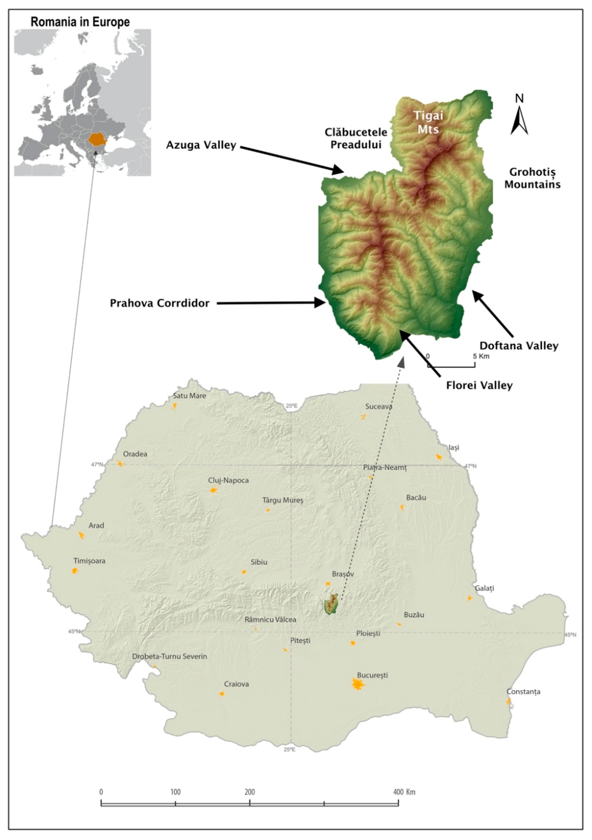
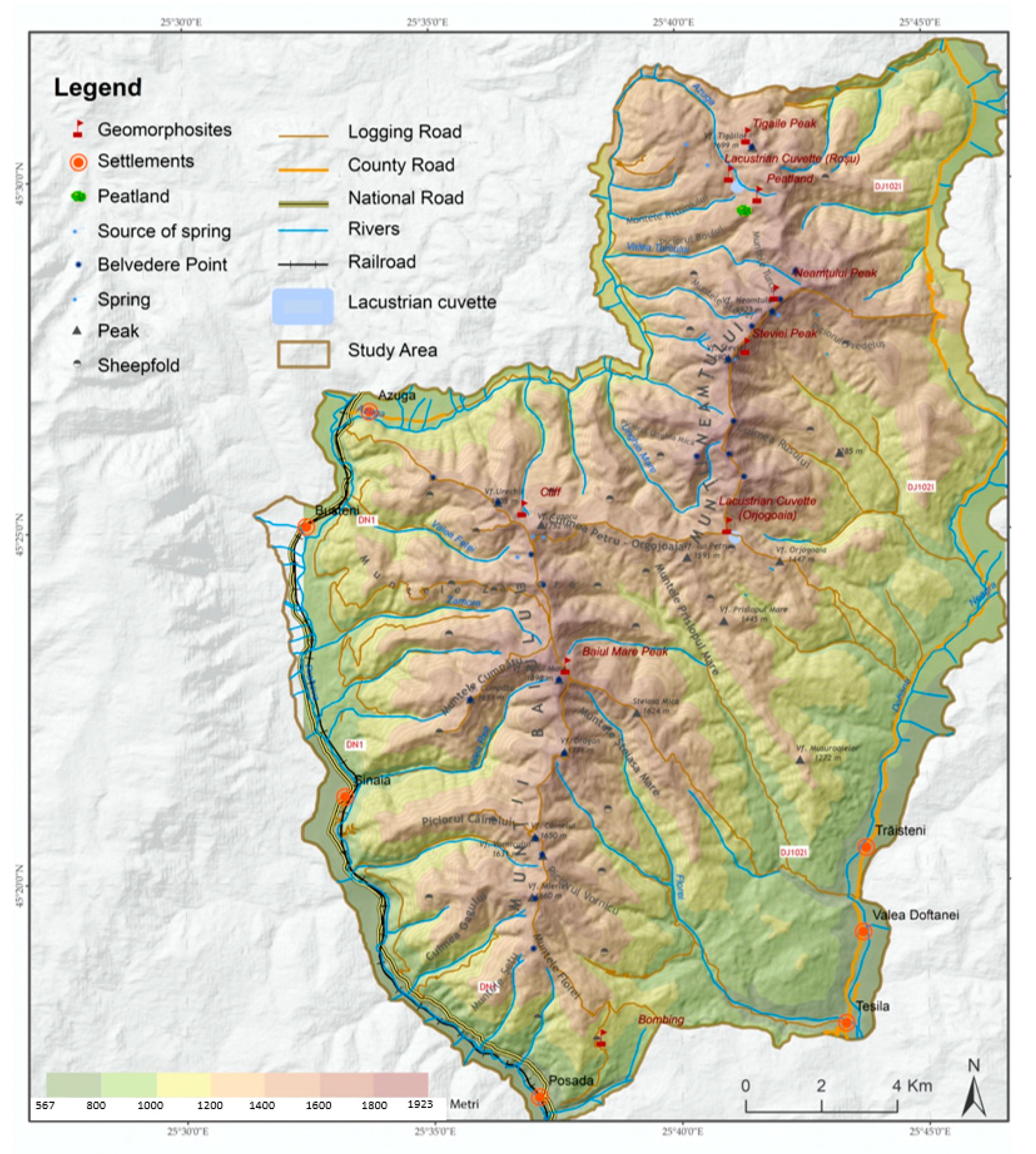
2.1. Study Area
2.2. Methodology
2.2.1. Method for the Inventory of Geomorphosites
2.2.2. Geomorphosites Classification
2.2.3. The Assessment of Geomorphosites
3. Results
3.1. Geomorphosites Tourist Value Assessment
3.1.1. Geomorphosites Scientific Value Assessment
3.1.2. Geomorphosite Scenic Value Assessment
3.1.3. Geomorphosite Cultural Value Assessment
3.1.4. Geomorphosites Economic Value Assessment
3.2. Geomorphosites Exploitation Value Assessment
3.2.1. Degree of Exploitation Value Assessment
3.2.2. Modality of Exploitation Value Assessment
4. Discussion
5. Conclusions
Author Contributions
Funding
Institutional Review Board Statement
Informed Consent Statement
Data Availability Statement
Conflicts of Interest
Appendix A

| Geomorphosite Name | Touristic Value (Vtour) | Exploitation Value Assesment | Total | |||||||||||||||||||||||||||
|---|---|---|---|---|---|---|---|---|---|---|---|---|---|---|---|---|---|---|---|---|---|---|---|---|---|---|---|---|---|---|
| Scenic Value (Vsce) | Scientific Value (Vsci) | Cultural Value (Vcult) | Economic Value | Degree of Exploitation (Vexpl) | Modality of Exploitation (Vmod) | |||||||||||||||||||||||||
| Sce1 | Sce2 | Sce3 | Sce4 | Sce5 | Sci1 | Sci2 | Sci3 | Sci4 | Sci5 | Sci6 | Cult1 | Cult2 | Cult3 | Cult4 | Cult5 | Eco1 | Eco2 | Eco3 | Eco4 | Eco5 | Expl1 | Expl2 | Expl3 | Expl4 | Mod1 | Mod2 | Mod3 | Mod4 | ||
| Nival Lacustrian Cuvette—Orjogoaia | 0.5 | 1 | 0.5 | 0.5 | 1 | 1 | 1 | 1 | 1 | 0.75 | 0.25 | 0.25 | 0 | 0 | 0 | 0 | 0.25 | 1 | 0.25 | 1 | 0.75 | 0.5 | 0 | 1 | 1 | 0.25 | 0.5 | 0.25 | 0.5 | 16 |
| Peatland cuvette Piciorul Boului | 0.25 | 0.25 | 0.75 | 0.75 | 0 | 1 | 1 | 0.5 | 0.75 | 0.75 | 1 | 0 | 0 | 0.25 | 0 | 0 | 0.25 | 0.75 | 0.25 | 1 | 0.5 | 0.5 | 0 | 1 | 1 | 0 | 0 | 0 | 0.25 | 12.75 |
| Cliff Culmea Cazacu | 0.5 | 1 | 0.25 | 0.5 | 0.5 | 1 | 1 | 0.25 | 1 | 0.5 | 0.25 | 0 | 0 | 0.75 | 0 | 0 | 0.25 | 1 | 0.5 | 1 | 0.25 | 0.25 | 0.5 | 1 | 1 | 0.5 | 0.5 | 0.5 | 1 | 15.75 |
| Pits resulting from bombing (Muntele Florei) | 0.25 | 0.5 | 0.25 | 0.25 | 0 | 1 | 0.75 | 0.25 | 0.5 | 0.25 | 0.5 | 0 | 0 | 0.25 | 0 | 0 | 0.25 | 1 | 0.5 | 1 | 0.75 | 0.25 | 0.5 | 1 | 1 | 0 | 0 | 0 | 0.75 | 11.75 |
| Petru-Orjogoaia Ridge | 1 | 0.5 | 1 | 0.5 | 0.5 | 0.5 | 0.5 | 0.5 | 1 | 0.25 | 0.75 | 0.75 | 0.25 | 0.5 | 0 | 1 | 0.5 | 1 | 0.75 | 1 | 0.75 | 1 | 1 | 1 | 1 | 0.75 | 0.75 | 0.5 | 1 | 20.5 |
| Nival lacustrian cuvette—Roșu | 0.25 | 0.25 | 0.25 | 0.5 | 0.5 | 0.5 | 0.25 | 0.25 | 0.5 | 0.25 | 0.5 | 0 | 0.25 | 0 | 0 | 0 | 0 | 1 | 0.25 | 1 | 0.25 | 0 | 0 | 1 | 1 | 0 | 0 | 0 | 0.25 | 9 |
| Baiu Mare Peak | 0.75 | 1 | 0.25 | 0.75 | 0.5 | 0.5 | 0.5 | 0.25 | 0 | 0.5 | 0.75 | 0 | 0.25 | 0 | 0 | 0 | 0 | 1 | 0.75 | 1 | 0.75 | 0.25 | 0.25 | 1 | 1 | 0.75 | 0.75 | 0.75 | 1 | 15.25 |
| Neamțu Peak | 1 | 0.75 | 0.25 | 1 | 0.5 | 0.5 | 0.5 | 0.25 | 0 | 0.5 | 0.75 | 0.25 | 0.25 | 0 | 0 | 0 | 0.25 | 1 | 0.75 | 1 | 0.75 | 0.25 | 0.25 | 1 | 1 | 0.75 | 0.75 | 0.75 | 1 | 16.25 |
| Țigăile Peak | 1 | 1 | 0.5 | 0.5 | 0.5 | 0.5 | 0.5 | 0.5 | 0 | 0.25 | 0.75 | 0.25 | 0.25 | 0 | 0 | 0 | 0.25 | 1 | 0.25 | 1 | 0.5 | 0.25 | 0.25 | 1 | 1 | 0.25 | 0.25 | 0.25 | 1 | 13.75 |
| Ștevia Peak | 1 | 0.75 | 0.25 | 0.5 | 0 | 0.5 | 0.5 | 0.25 | 0 | 0.25 | 0.75 | 0.25 | 0.25 | 0 | 0 | 0 | 0.25 | 1 | 0.75 | 1 | 0.5 | 0.25 | 0.25 | 1 | 1 | 0.25 | 0.25 | 0.25 | 1 | 13 |
References
- Candea, M.; Simion, T.; Bogdan, E. Patrimoniul Turistic al Romaniei; Editura Universitara: Bucharest, Romania, 2021. [Google Scholar]
- Cocean, P.; Vlăsceanu, G.; Negoescu, B. Geografia Generală a Turismului; Editura Meteor Press: Bucharest, Romania, 2003. [Google Scholar]
- Cocean, P. Potențialul Economic al Carstului din Munții Apuseni; Editura Academiei: Bucharest, Romania, 1984. [Google Scholar]
- Reynard, E.; Cortaza, P.; Geraldine, R.B. Geomorphosites; Verlag Dr. Friedrich Pfeil: Munchen, Germany, 2009. [Google Scholar]
- Reynard, E. Encyclopedia de Geomorphology, Geosite; Goudie, A., Ed.; Routledge: London, UK, 2004; p. 440. [Google Scholar]
- Panizza, M. Geomorphosites: Concepts, methods and examples of geomorphological survey. Chin. Sci. Bull. 2001, 46, 4–5. [Google Scholar] [CrossRef]
- Comănescu, L.; Nedelea, A. Analysis of Some Representaive Geomorphosites in the Bucegi Mountains between Scientific Evaluation and Tourist Perception. 2010. Available online: http://www3.interscience.wiley.com/journal/119879254/issue (accessed on 15 July 2021).
- Comănescu, L.; Dobre, R. Inventory, Evaluating and Tourism Valuating from the central sector of the Ceahlau National Park. Geoj. Tour. Geosites 2009, 3, 86–96. [Google Scholar]
- Petrea, D. Obiect, Metodă Și Cunoaștere Geografică; Universității din Oradea: Oradea, Romania, 2005. [Google Scholar]
- Mutihac, V. Structura Geologica a Teritoriului Romaniei; Editura Tehnica: Bucuresti, Romania, 1990. [Google Scholar]
- Niculescu, G.H. Muntii Garbova—Caractere Geomorfologice, Studii si comunicari; Institutul de Geografie: Bucuresti, Romania, 1980. [Google Scholar]
- Ielenicz, M. Muntii Baiului, Caracterizare Geomorfologica, Analele Universitatii Bucuresti; Seria Geografie: Bucuresti, Romania, 1981. [Google Scholar]
- Trif, S. Muntii Baiului. Analiza Susceptibilitatii Terenurilor la Eroziunea in Suprafata; Trif Septimius: Brasov, Romania, 2018; ISBN 978-973-0-26232-2. [Google Scholar]
- Comănescu, L.; Nedelea, A. Geomorphosites assessments of the glacial and periglacial landform Dynamics and Evolution in Romania. Digit. Shutdowns Soc. Media 2017, 215–249. [Google Scholar] [CrossRef]
- Cocean, G. Inventory Card for Regionally Relevant Geomorphosites. Rom. Rev. Reg. Stud. 2011, 7, 131–136. [Google Scholar]
- Reynard, E. Geomorphosites and paysages. Geomorphol. Relief Process. Environ. 2005, 3, 181–188. [Google Scholar] [CrossRef] [Green Version]
- Grandgirard, V. L’evaluation des geotopes. Geol. Insubrica 1999, 4, 59–66. [Google Scholar]
- Pralong, J.-P. A method for assessing tourist potential and use of geomorphological sites. Géomorphologie Relief Process. Environ. 2005, 11, 189–196. [Google Scholar] [CrossRef]
- Grandgirard, V. Geomorphologie, Protection de la Nature et Gestión du Paysage. Ph.D. Thesis, Faculte des Sciences, Universite de Fribourg, Fribourg, Germany, 1997. [Google Scholar]
- Quaranta, G. Geomorphological Assets: Conceptual Aspect and Application in the Area of Croda da Lago (Cortina D’Ampezzo, Dolomites). In First European Intensive Course on Applied Geomorphology, Modena—Cortina d’Ampezzo; Panizza, M., Soldati, M., Barani, D., Eds.; Istituto di Geologia: Modena, Italy, 1992; pp. 49–60. [Google Scholar]
- Cortaza, P.; Giusti, C. Methodological proposal for the assessment of the scientific quality of geomorphosites. II Quaternario 2005, 18, 307–313. [Google Scholar]
- Rojsek, D. Inventarisation of the Natural Heritage. Acta Carsologica 2004, XXIII, 113–119. [Google Scholar]
- Rivas, V.; Rix, K.; Francés, E.; Cendrero, A.; Brunsden, D. Assessing impacts on landforms. ITC J. 1995, 4, 316–320. [Google Scholar]
- Panizza, M. Relations Homme–Environnement L’exemple D’une Recherche Géomorphologique de L’UNION Européenne. In Il Sistema Uomo–Ambiente tra Passato e Presente; Livadie, C.A., Ortolani, F., Eds.; Edipuglia: Bari, Italy, 1998; pp. 307–309. [Google Scholar]
- Portal Legislativ. Available online: http://legislatie.just.ro/Public/DetaliiDocument/41760 (accessed on 8 July 2021).
- Cavallin, A.; Marchetti, M.; Panizza, M. Geomorphology and environmental impact assessment: A methodologic approach. ITC J. 1995, 4, 308–310. [Google Scholar]


| Inventory Sheet of Geomorphosites | |
|---|---|
| Name—The Depression of Orjogoaia Nival Lake Altitude—1483 m Morphological Unit—Petru Orjogoaia Ridge | |
| Tourist Value Assessment | |
| Scientific value (VsciG) | The paleogeographic interest of the site as a witness for the reconstruction of the morphodynamic development of the lake depression—1 p The tank of the lake is representative of the evolution of the lake. The characteristics of the site are educational in studying geomorphology—1 p The score is evaluated by the size of the area of geomorphosite divided by the whole area occupied by all identical geomorphosites in the studied territory—1 p As it is unique, it scored its highest score on the uniqueness chapter (related to the Baiului M. area)—1 p Despite the fact that the geomorphosite is on the Petru-Orjogoaia Ridge, which is intensively circulated, it keeps well, with very few signs of degradation (tourists can get on the banks and degrade them)—0.75 The diversity of flora and fauna is reduced in the area. The most common one is Deschampsia caespitosa (tufted hairgrass), grows in high humidity areas, and is a thick bush, having 60–120 cm height; it does not live in the dry season, and it is well-suited to grazing—0.25 p |
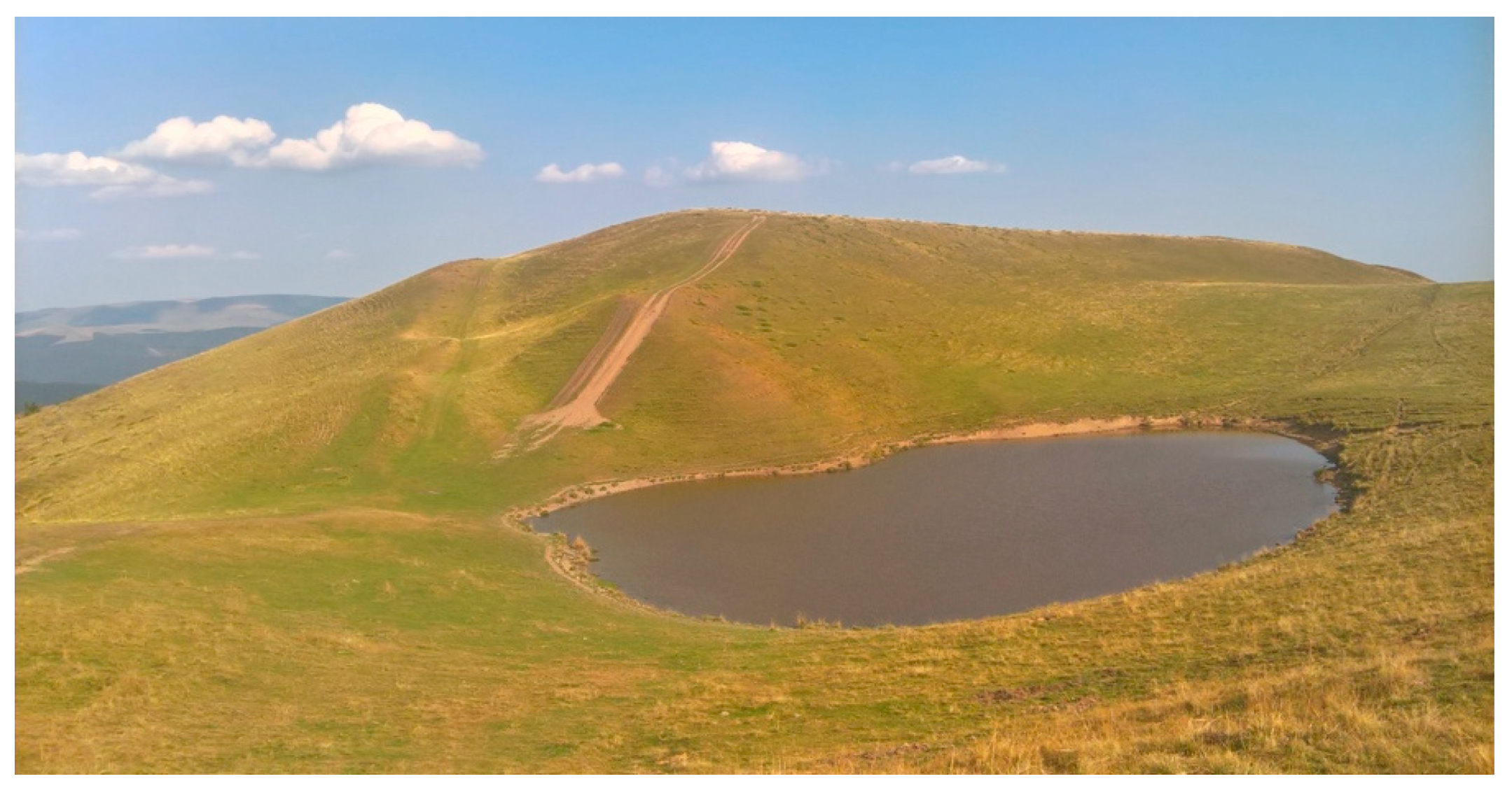
| Scenic value (VsceG) | It is taken into consideration the number of panoramic view places accessible on a trail/road. Each one of them needs to have a specific angle of observation and it has to be located less than 1 km away from the geomorphosite (Orjogoaia Peak)—0.25 p Average distance to the panoramic view places (more than 500 m)—1 p Size: The entire ground of the geomorphosite is taken into consideration. The score obtained for the size criteria (ha) is defined based on all the other similar geomorphosites within the studied area (out of all the existent nival depressions, namely the ones on the Șteiasa Ridge, on Sorica Ridge, on Baiu Mare Ridge), Orjogoaia Lake Depression is the largest—1 p Orjogoaia Lake Depression received a score of 0.75 because the lake depression on the Sorica is situated at 1560 m altitude, and the one on the Șteiasa at 1520 m. Color contrast of the geomorphosite with its surroundings: A particular colour includes all numerous shadows; dark, black, gray or light gray are considered to be identical colours. The lake has a dark blue colour, and the surroundings are from yellow to light green—1 p. |
| Cultural value (VcultG) | The symbolic relevance of geomorphosite is very low—0.25 p Orjogoaia Depression/Lake is not included in the category of iconographic representations such as drawings, paintings, photographs—0 p Historical, architectural and archaeological vestiges or buildings are missing—0 p The religious or metaphysical relevance of the site as well as folk traditions/beliefs they don‘t take place in this area—0 p There is no artistic or cultural event related to the geomorphosite or has ever been—0 p |
| Economic value (VecoG) | The Orjogoaia Lake/depression is less than one km from the access road (trail). Access can be provided with 4×4 vehicles, bicycles, motorcycles—0.25 p There are no natural risks. No avalanches, falling stones, torches, etc. are formed—1 p Every year, the number of tourists transiting the area is between 10.000 and 100.000—0.25 p Orjogoaia Depression Lake is not protected from a geomorphosite point of view—1 p In terms of tourism importance, it is known nationally—0.75 |
| Exploitation value assessment | |
| Degree of exploitation (DeG) | The depression of the Orjogoaia Lake is accessible and is located on the Petru-Orjogoaia Interfluve, so that the area in the vicinity is used for tourism purposes—0.5 p Transport infrastructure, accommodation, restaurant, souvenirs/tourist guides within the geomorphosite area is missing (paths not included)—0 p The geomorphosite is visited year-round—1 p The depression of the Orjogoaia lake can be used for tourism and visited in a day’s time—1 p |
| Geomorphosite Name | Origin | Type | Code |
|---|---|---|---|
| a. Nival lacustrine depression—Orjogoaia | Nival/Periglaciar | Areal | PHNIV01 |
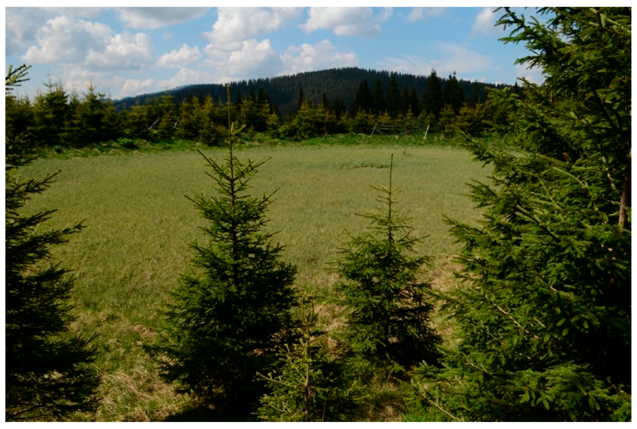
| b. Peatland depression Piciorul Boului | Periglaciar | Areal | PHPER02 |
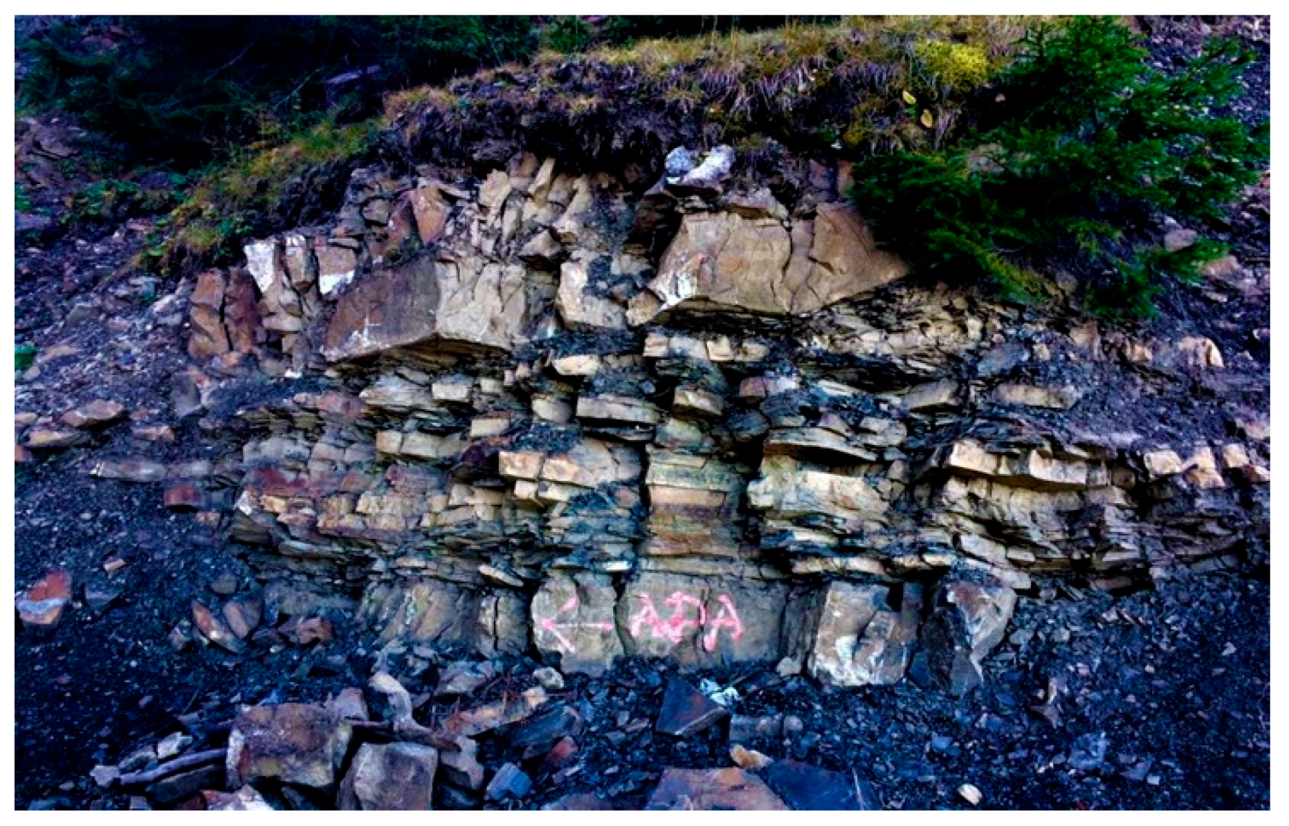
| c. Cliff—Culmea Cazacu | Differential erosion | Punctual | PHED03 |
| d. Pits/itches resulting from bombing (Muntele Florei) | Anthropogenic | Areal | PHANT04 |
| e. Petru-Orjogoaia Ridge | Morphological | Linear | PHM05 |
| f. Nival lacustrine depression—Roșu | Nival | Areal | PHNIV06 |
| g. Baiu Mare Peak | Morphological | Punctual | PHM07 |
| h. Neamțu Peak | Morphological | Punctual | PHM08 |
| i. Țigăile Peak | Morphological | Punctual | PHM09 |
| j. Ștevia Peak | Morphological | Punctual | PHM10 |
| No. crt | Geomorphosite Name | Scientific Value | Scenic Value | Cultural Value | Economic Value | Total Value |
|---|---|---|---|---|---|---|
| 1 | Nival lacustrine depression—Orjogoaia | 0.83 | 0.7 | 0.05 | 0.7 | 0.57 |
| 2 | Peatland depression Piciorul Boului | 0.83 | 0.4 | 0.05 | 0.55 | 0.46 |
| 3 | Cliff—Cazacu Ridge Differential Erosion | 0.66 | 0.55 | 0.15 | 0.6 | 0.49 |
| 4 | Petru-Orjogoaia Ridge | 0.58 | 0.7 | 0.50 | 0.8 | 0.65 |
| 5 | Baiu Mare Peak | 0.42 | 0.65 | 0.10 | 0.7 | 0.47 |
| 6 | Neamțu Peak | 0.58 | 0.7 | 0.10 | 0.8 | 0.55 |
| 7 | Țigăile Peak | 0.42 | 0.7 | 0.10 | 0.6 | 0.45 |
| 8 | Ștevia Peak | 0.42 | 0.5 | 0.10 | 0.7 | 0.43 |
| 9 | Nival lacustrine depression—Roșu | 0.38 | 0.35 | 0.05 | 0.5 | 0.32 |
| 10 | Pits/ditches resulting from bombing (Florei Mountain) | 0.54 | 0.25 | 0.05 | 0.7 | 0.39 |
| Nr. crt | Geomorphosite Name | Scientific Value | ||||||
|---|---|---|---|---|---|---|---|---|
| VsG1 | VsG2 | VsG3 | VsG4 | VsG5 | VsG6 | Total | ||
| 1 | Nival lacustrine depression—Orjogoaia | 1 | 1 | 1 | 1 | 0.75 | 0.25 | 0.83 |
| 2 | Peatland depression Piciorul Boului | 1 | 1 | 0.5 | 0.75 | 0.75 | 1 | 0.83 |
| 3 | Cliff—Cazacu Ridge Differential Erosion | 1 | 1 | 0.25 | 1 | 0.5 | 0.25 | 0.66 |
| 4 | Petru-Orjogoaia Ridge | 0.5 | 0.5 | 0.5 | 1 | 0.25 | 0.75 | 0.58 |
| 5 | Baiu Mare Peak | 0.5 | 0.5 | 0.25 | 0 | 0.5 | 0.75 | 0.42 |
| 6 | Neamțu Peak | 0.5 | 0.5 | 0.25 | 1 | 0.5 | 0.75 | 0.58 |
| 7 | Țigăile Peak | 0.5 | 0.5 | 0.5 | 0 | 0.25 | 0.75 | 0.42 |
| 8 | Ștevia Peak | 0.5 | 0.5 | 0.25 | 0 | 0.25 | 0.75 | 0.42 |
| 9 | Nival lacustrine depression—Roșu | 0.5 | 0.25 | 0.25 | 0.5 | 0.25 | 0.5 | 0.38 |
| 10 | Pits/ditches resulting from bombing (Florei Mountain) | 1 | 0.75 | 0.25 | 0.5 | 0.25 | 0.5 | 0.54 |
| No. crt | Geomorphosite Name | Scenic Value | |||||
|---|---|---|---|---|---|---|---|
| Vsce1 | Vsce2 | Vsce3 | Vsce4 | Vsce5 | Total | ||
| 1 | Nival lacustrine depression—Orjogoaia | 0.5 | 1 | 0.5 | 0.5 | 1 | 0.7 |
| 2 | Peatland depression Piciorul Boului | 0.25 | 0.25 | 0.75 | 0.75 | 0 | 0.4 |
| 3 | Cliff—Cazacu Ridge Differential Erosion | 0.5 | 1 | 0.25 | 0.5 | 0.5 | 0.55 |
| 4 | Petru-Orjogoaia Ridge | 1 | 0.5 | 1 | 0.5 | 0.5 | 0.7 |
| 5 | Baiu Mare Peak | 0.75 | 1 | 0.25 | 0.75 | 0.5 | 0.65 |
| 6 | Neamțu Peak | 1 | 0.75 | 0.25 | 1 | 0.5 | 0.7 |
| 7 | Țigăile Peak | 1 | 1 | 0.5 | 0.5 | 0.5 | 0.7 |
| 8 | Ștevia Peak | 1 | 0.75 | 0.25 | 0.5 | 0 | 0.5 |
| 9 | Nival lacustrine depression—Roșu | 0.25 | 0.25 | 0.25 | 0.5 | 0.5 | 0.35 |
| 10 | Pits/ditches resulting from bombing (Florei Mountain) | 0.25 | 0.5 | 0.25 | 0.25 | 0 | 0.25 |
| No. crt | Geomorphosite Name | Economic Value | |||||
| E1 | E2 | E3 | E4 | E5 | Total | ||
| 1 | Nival lacustrian cuvette—Orjogoaia | 0.25 | 1 | 0.25 | 1 | 0.75 | 0.65 |
| 2 | Peatland cuvette Piciorul Boului | 0.25 | 0.75 | 0.25 | 1 | 0.5 | 0.55 |
| 3 | Cliff—Cazacu Ridge Differential Erosion | 0.25 | 1 | 0.5 | 1 | 0.25 | 0.6 |
| 4 | Petru-Orjogoaia Ridge | 0.5 | 1 | 0.75 | 1 | 0.75 | 0.8 |
| 5 | Baiu Mare Peak | 0 | 1 | 0.75 | 1 | 0.75 | 0.7 |
| 6 | Neamțu Peak | 0.25 | 1 | 0.75 | 1 | 0.75 | 0.8 |
| 7 | Țigăile Peak | 0.25 | 1 | 0.25 | 1 | 0.5 | 0.6 |
| 8 | Ștevia Peak | 0.25 | 1 | 0.75 | 1 | 0.5 | 0.7 |
| 9 | Nival lacustrian cuvette—Roșu | 0 | 1 | 0.25 | 1 | 0.25 | 0.5 |
| 10 | Pits/ditches resulting from bombing (Florei Mountain) | 0.25 | 1 | 0.5 | 1 | 0.75 | 0.7 |
| No. crt | Geomorphosite Name | Cultural Value | |||||
|---|---|---|---|---|---|---|---|
| VcG1 | VcG2 | VcG3 | VcG4 | VcG5 | Total | ||
| 1 | Nival lacustrine depression—Orjogoaia | 0.25 | 0 | 0 | 0 | 0 | 0.05 |
| 2 | Peatland depression Piciorul Boului | 0 | 0 | 0.25 | 0 | 0 | 0.05 |
| 3 | Cliff—Cazacu Ridge Differential Erosion | 0 | 0 | 0.75 | 0 | 0 | 0.15 |
| 4 | Petru-Orjogoaia Ridge | 0.75 | 0.25 | 0.5 | 0 | 1 | 0.50 |
| 5 | Baiu Mare Peak | 0.25 | 0.25 | 0 | 0 | 0 | 0.10 |
| 6 | Neamțu Peak | 0.25 | 0.25 | 0 | 0 | 0 | 0.10 |
| 7 | Țigăile Peak | 0.25 | 0.25 | 0 | 0 | 0 | 0.10 |
| 8 | Ștevia Peak | 0.25 | 0.25 | 0 | 0 | 0 | 0.10 |
| 9 | Nival lacustrine depression—Roșu | 0 | 0.25 | 0 | 0 | 0 | 0.05 |
| 10 | Pits/ditches resulting from bombing (Florei Mountain) | 0 | 0 | 0.25 | 0 | 0 | 0.05 |
| No. crt | Geomorphosite Name | Economic Value | |||||
|---|---|---|---|---|---|---|---|
| E1 | E2 | E3 | E4 | E5 | Total | ||
| 1 | Nival lacustrine depression—Orjogoaia | 0.25 | 1 | 0.25 | 1 | 0.75 | 0.65 |
| 2 | Peatland depression Piciorul Boului | 0.25 | 0.75 | 0.25 | 1 | 0.5 | 0.55 |
| 3 | Cliff—Cazacu Ridge Differential Erosion | 0.25 | 1 | 0.5 | 1 | 0.25 | 0.6 |
| 4 | Petru-Orjogoaia Ridge | 0.5 | 1 | 0.75 | 1 | 0.75 | 0.8 |
| 5 | Baiu Mare Peak | 0 | 1 | 0.75 | 1 | 0.75 | 0.7 |
| 6 | Neamțu Peak | 0.25 | 1 | 0.75 | 1 | 0.75 | 0.8 |
| 7 | Țigăile Peak | 0.25 | 1 | 0.25 | 1 | 0.5 | 0.6 |
| 8 | Ștevia Peak | 0.25 | 1 | 0.75 | 1 | 0.5 | 0.7 |
| 9 | Nival lacustrine depression—Roșu | 0 | 1 | 0.25 | 1 | 0.25 | 0.5 |
| 10 | Pits/ditches resulting from bombing (Florei Mountain) | 0.25 | 1 | 0.5 | 1 | 0.75 | 0.7 |
| No. crt | Geomorphosite Name | Degree of Exploitation | ||||
|---|---|---|---|---|---|---|
| Deg1 | Deg2 | Deg3 | Deg4 | Total | ||
| 1 | Nival lacustrine depression—Orjogoaia | 0.5 | 0 | 1 | 1 | 0.63 |
| 2 | Peatland depression Piciorul Boului | 0.5 | 0 | 1 | 1 | 0.63 |
| 3 | Cliff—Cazacu Ridge Differential Erosion | 0.25 | 0.5 | 1 | 1 | 0.69 |
| 4 | Petru-Orjogoaia Ridge | 1 | 1 | 1 | 1 | 1 |
| 5 | Baiu Mare Peak | 0.25 | 0.25 | 1 | 1 | 0.63 |
| 6 | Neamțu Peak | 0.25 | 0.25 | 1 | 1 | 0.63 |
| 7 | Țigăile Peak | 0.25 | 0.25 | 1 | 1 | 0.63 |
| 8 | Ștevia Peak | 0.25 | 0.25 | 1 | 1 | 0.63 |
| 9 | Nival lacustrine depression—Roșu | 0 | 0 | 1 | 1 | 0.5 |
| 10 | Pits/ditches resulting from bombing (Florei Mountain) | 0.25 | 0.5 | 1 | 1 | 0.69 |
| No. crt | Geomorphosite Name | Modality of Exploitation | ||||
|---|---|---|---|---|---|---|
| Mod1 | Mod2 | Mod3 | Mod4 | Total | ||
| 1 | Nival lacustrine depression—Orjogoaia | 0.25 | 0.5 | 0.25 | 0.5 | 0.38 |
| 2 | Peatland depression Piciorul Boului | 0 | 0 | 0 | 0.25 | 0.06 |
| 3 | Cliff—Cazacu Ridge Differential Erosion | 0.5 | 0.5 | 0.5 | 1 | 0.63 |
| 4 | Petru-Orjogoaia Ridge | 0.75 | 0.75 | 0.5 | 1 | 0.75 |
| 5 | Baiu Mare Peak | 0.75 | 0.75 | 0.75 | 1 | 0.81 |
| 6 | Neamțu Peak | 0.75 | 0.75 | 0.75 | 1 | 0.81 |
| 7 | Țigăile Peak | 0.25 | 0.25 | 0.25 | 1 | 0.44 |
| 8 | Ștevia Peak | 0.25 | 0.25 | 0.25 | 1 | 0.44 |
| 9 | Nival lacustrine depression—Roșu | 0 | 0 | 0 | 0.25 | 0.06 |
| 10 | Pits/ditches resulting from bombing (Florei Mountain) | 0 | 0 | 0 | 0.75 | 0.19 |
Publisher’s Note: MDPI stays neutral with regard to jurisdictional claims in published maps and institutional affiliations. |
© 2021 by the authors. Licensee MDPI, Basel, Switzerland. This article is an open access article distributed under the terms and conditions of the Creative Commons Attribution (CC BY) license (https://creativecommons.org/licenses/by/4.0/).
Share and Cite
Barbălată, L.; Comănescu, L. Environmental Sustainability and the Inclusion of Geomorphosites in Tourist Activity—Case Study: The Baiului Mountains, Romania. Sustainability 2021, 13, 8094. https://doi.org/10.3390/su13148094
Barbălată L, Comănescu L. Environmental Sustainability and the Inclusion of Geomorphosites in Tourist Activity—Case Study: The Baiului Mountains, Romania. Sustainability. 2021; 13(14):8094. https://doi.org/10.3390/su13148094
Chicago/Turabian StyleBarbălată (Alb), Ligia, and Laura Comănescu. 2021. "Environmental Sustainability and the Inclusion of Geomorphosites in Tourist Activity—Case Study: The Baiului Mountains, Romania" Sustainability 13, no. 14: 8094. https://doi.org/10.3390/su13148094
APA StyleBarbălată, L., & Comănescu, L. (2021). Environmental Sustainability and the Inclusion of Geomorphosites in Tourist Activity—Case Study: The Baiului Mountains, Romania. Sustainability, 13(14), 8094. https://doi.org/10.3390/su13148094