Framework for Spatial and Temporal Monitoring of Urban Forest and Vegetation Conditions: Case Study Zagreb, Croatia
Abstract
1. Introduction
2. Materials and Methods
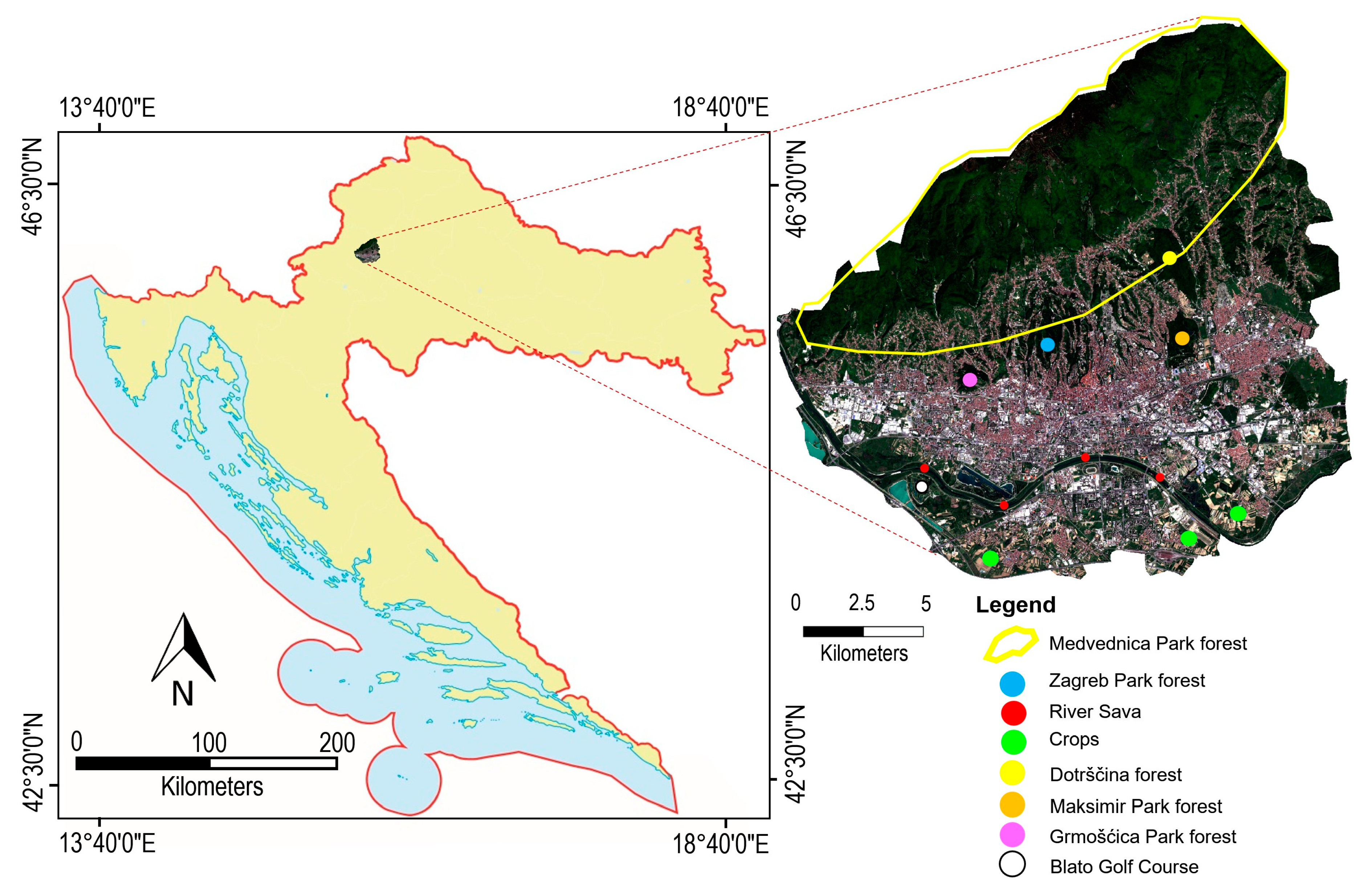
2.1. Study Area and Data Sources
2.2. Satellite Data and Preprocessing
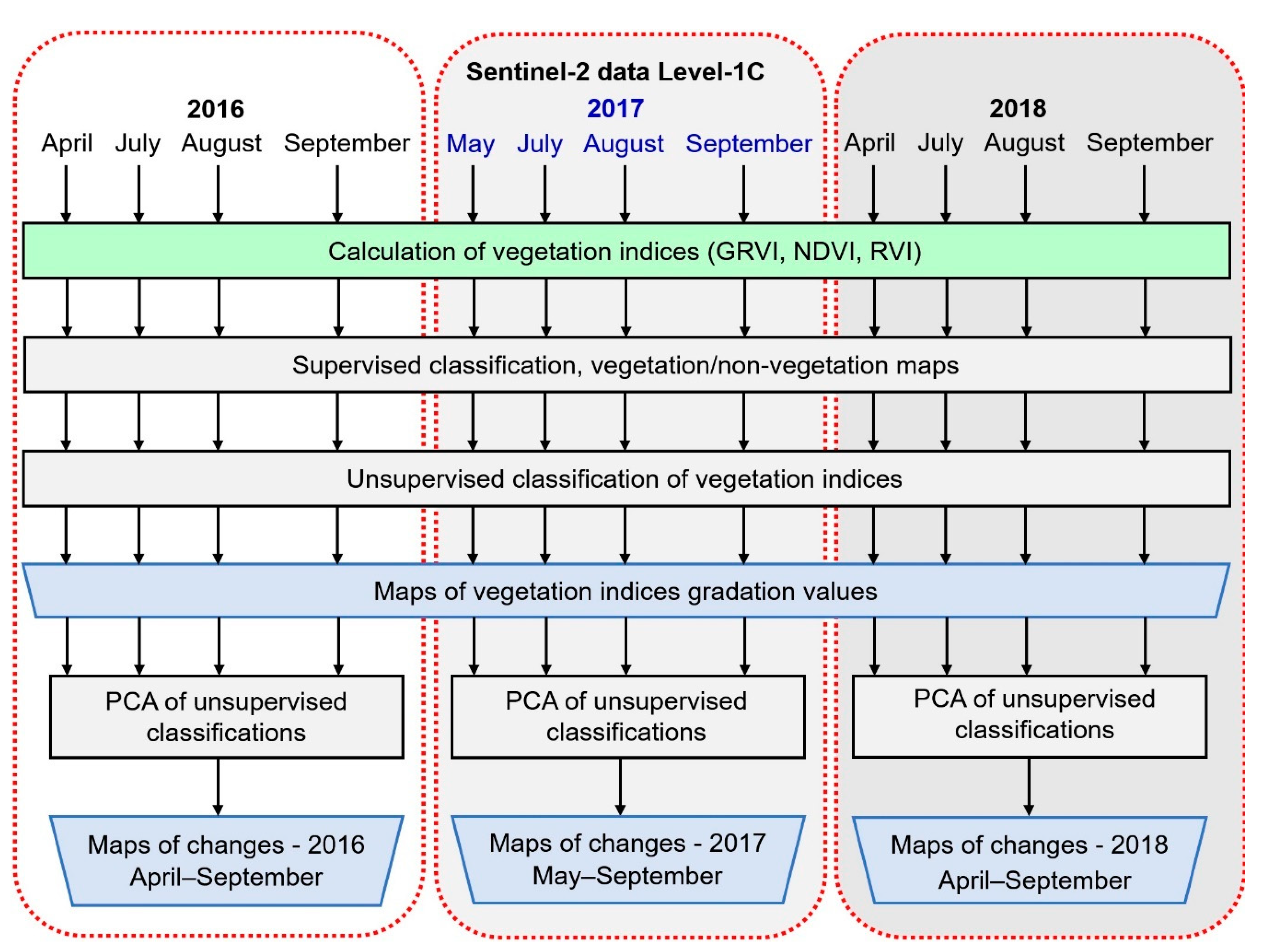
2.3. Methods
- Calculation of vegetation indices
- Supervised classification for obtaining the urban vegetation (maximum likelihood algorithm was used in this study)
- Unsupervised classification of vegetation indices (NDVI, RVI, GRVI) using the K-means method
- Principal components analysis-based change detection of unsupervised classification results of vegetation indices.
2.3.1. Vegetation Indices
2.3.2. Urban Vegetation Supervised Classification and Mask
2.3.3. Unsupervised Classification of Vegetation Indices
- chosen distance measure between a data point and the cluster centre ,
- data point,
- cluster center,
- n = data points, and
- k = number of class.
2.3.4. Principal Components Analysis-Based Change Detection
3. Results and Discussion
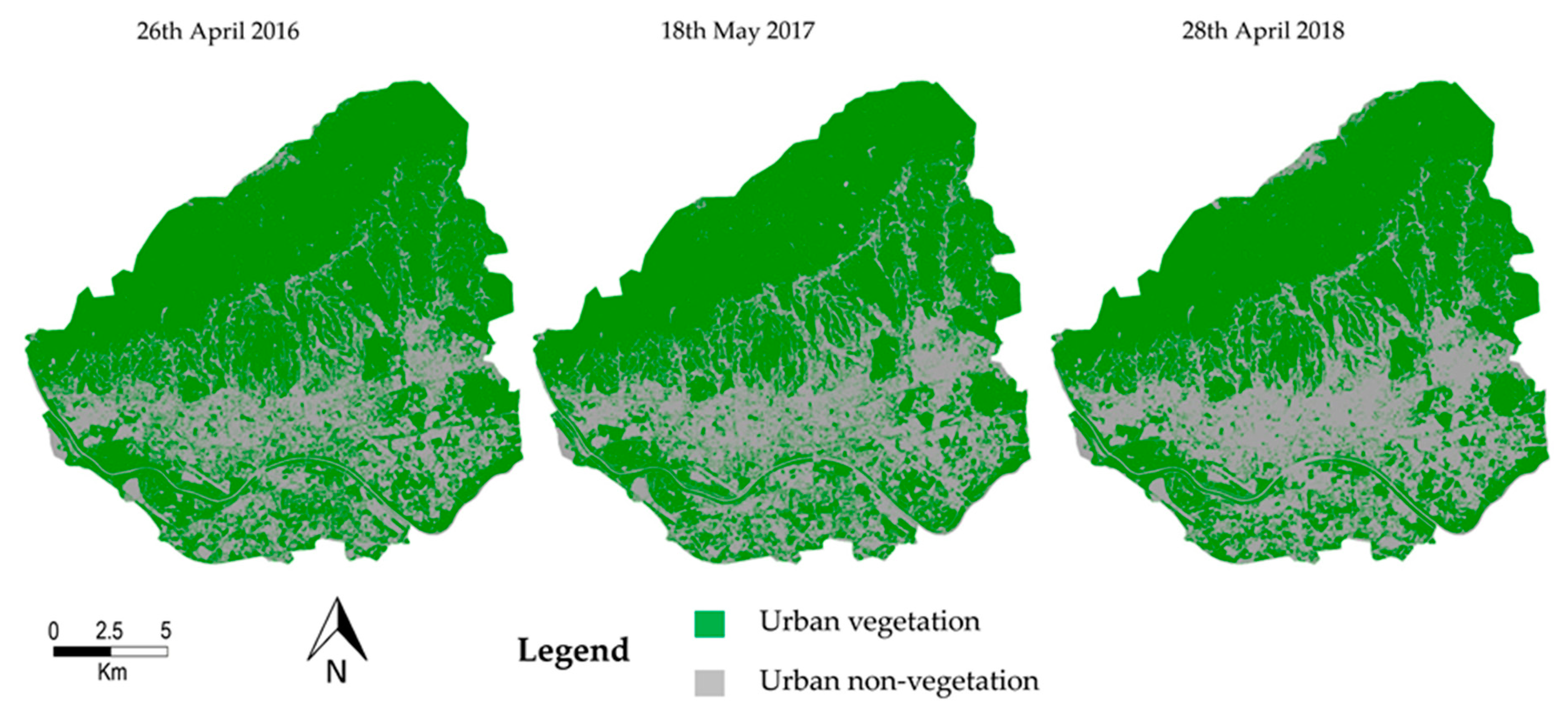
3.1. Supervised Classification Outputs
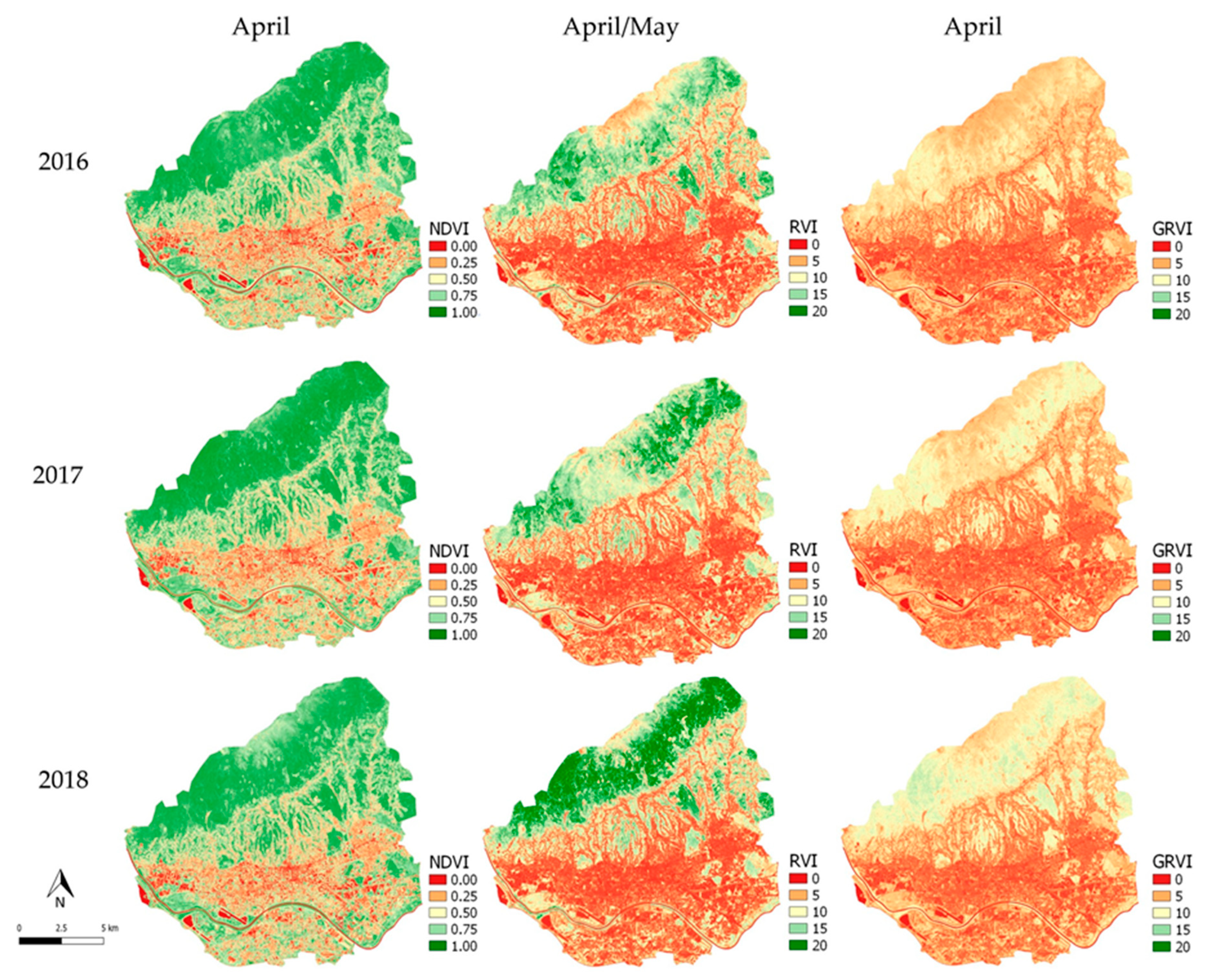
3.2. Vegetation Indices Analysis
3.3. Unsupervised Classification Outputs
3.4. Principal Components Analysis of Unsupervised Classification Outputs
4. Conclusions
Author Contributions
Funding
Institutional Review Board Statement
Informed Consent Statement
Data Availability Statement
Conflicts of Interest
References
- Wenze, Z.; Haochuan, L. Urban vegetation coverage monitoring technology based on NDVI. In Advances in Engineering Research, Proceedings of 7th International Conference on Energy, Environment and Sustainable Development (ICEESD 2018), Shenzhen, China, 30–31 March 2018; Kim, Y.H., Ed.; Atlantis Science Co. Ltd.: Beijing, China, 2018; Volume 163, ISSN 2352-5401; ISBN 978-94-6252-503-0. [Google Scholar]
- Bolund, P.; Hunhammar, S. Ecosystem services in urban areas. Ecol. Econ. 1999, 29, 293–301. [Google Scholar] [CrossRef]
- Bernatzky, A. The contribution of trees and green spaces to a town climate. Energy Build. 1982, 5, 1–10. [Google Scholar] [CrossRef]
- Escobedo, F.J.; Giannico, V.; Jim, C.Y.; Sanesi, G.; Lafortezza, R. Urban forests, ecosystem services, green infrastructure and nature-based solutions: Nexus or evolving metaphors? Urban. For. Urban. Green. 2019, 37, 3–12. [Google Scholar] [CrossRef]
- Sanesi, G.; Gallis, C.; Kasperidus, H.D. Urban Forests and Their Ecosystem Services in Relation to Human Health. In Forests, Trees and Human Health; Nilsson, K., Sangster, M., Gallis, C., Hartig, T., de Vries, S., Seeland, K., Schipperijn, J., Eds.; Springer: Dordrecht, The Netherlands, 2011; pp. 23–40. ISBN 978-90-481-9806-1. [Google Scholar]
- Zhang, X.X.; Wu, P.F.; Chen, B. Relationship between vegetation greenness and urban heat island effect in Beijing City of China. Procedia Environ. Sci. 2010, 2, 1438–1450. [Google Scholar] [CrossRef]
- Gallo, K.P.; Tarpley, J.D.; McNab, A.L.; Karl, T.R. Assessment of urban heat islands: A satellite perspective. Atmos. Res. 1995, 37, 37–43. [Google Scholar] [CrossRef]
- Nichol, J.E. High-Resolution Surface Temperature Patterns Related to Urban Morphology in a Tropical City: A Satellite-Based Study. J. Appl. Meteorol. 1996, 35, 135–146. [Google Scholar] [CrossRef]
- Foley, J.A.; DeFries, R.; Asner, G.P.; Barford, C.; Bonan, G.; Carpenter, S.R.; Chapin, F.S.; Coe, M.T.; Daily, G.C.; Gibbs, H.K.; et al. Global consequences of land use. Science 2005, 309, 570–574. [Google Scholar] [CrossRef] [PubMed]
- Wong, N.H.; Yu, C. Study of green areas and urban heat island in a tropical city. Habitat Int. 2005, 29, 547–558. [Google Scholar] [CrossRef]
- Grimmond, C.S.B.; Souch, C.; Hubble, M.D. Influence of tree cover on summertime surface energy balance fluxes, San Gabriel Valley, Los Angeles. Clim. Res. 1996, 6, 645–657. [Google Scholar] [CrossRef]
- Nowak, D.J.; Dwyer, J.F. Understanding the benefits and costs of urban forest ecosystems. In Urban and Community Forestry in the Northeast; Kuser, J., Ed.; Plenum Pub I: New York, NY, USA, 2000; Volume II, pp. 25–46. [Google Scholar]
- Kamusoko, C. Importance of remote sensing and land change modeling for urbanization studies. In Urban Development in Asia and Africa; Springer: Singapore, 2017; pp. 3–10. [Google Scholar]
- Li, X.; Chen, W.Y.; Sanesi, G.; Lafortezza, R. Remote Sensing in Urban Forestry: Recent Applications and Future Directions. Remote Sens. 2019, 11, 1144. [Google Scholar] [CrossRef]
- Erener, A. Remote sensing of vegetation health for reclaimed areas of Seyitömer open cast coal mine. Int. J. Coal Geol. 2011, 86, 20–26. [Google Scholar] [CrossRef]
- Fatiha, B.; Abdelkader, A.; Latifa, H.; Mohamed, E. Spatio Temporal Analysis of Vegetation by Vegetation Indices from Multi-dates Satellite Images: Application to a Semi Arid Area in ALGERIA. Energy Procedia 2013, 36, 667–675. [Google Scholar] [CrossRef]
- RST, 2010. Remote sensing Tutorial. Vegetation Applications: Agriculture, Forestry, and Ecology. General Principles for Recognizing Vegetation. Available online: http://www.rst.gsfc.nasa.gov/Sect3/Sect3_1.html (accessed on 5 May 2021).
- Tooke, R.T.; Coops, N.C.; Goodwin, N.R.; Voog, J.A. Extracting urban vegetation characteristics using spectral mixture analysis and tree classification. Remote Sens. Environ. 2009, 113, 398–407. [Google Scholar] [CrossRef]
- Wang, W.; Liu, R.; Gan, F.; Zhou, P.; Zhang, X.; Ding, L. Monitoring and Evaluating Restoration Vegetation Status in Mine Region Using Remote Sensing Data: Case Study in Inner Mongolia, China. Remote Sens. 2021, 13, 1350. [Google Scholar] [CrossRef]
- Mensah, A.A.; Sarfo, A.D.; Partey, S.T. Assessment of vegetation dynamics using remote sensing and GIS: A case of Bosomtwe Range Forest Reserve, Ghana. Egypt. J. Remote Sens. Space Sci. 2019, 22, 145–154. [Google Scholar] [CrossRef]
- Tigges, J.; Lakes, T.; Hostert, P. Urban vegetation classification: Benefits of multi temporal RapidEye satellite data. Remote Sens. Environ. 2013, 136, 66–75. [Google Scholar] [CrossRef]
- Davies, K.W.; Sheley, R.L. Promoting Native Vegetation and Diversity in Exotic Annual Grass Infestations. Restor. Ecol. 2011, l9, 159–165. [Google Scholar] [CrossRef]
- Huete, A.R. Vegetation Indices, Remote Sensing and Forest Monitoring. Geogr. Compass 2012, 6, 513–532. [Google Scholar] [CrossRef]
- Engler, R.; Waser, L.T.; Zimmennann, N.E.; Schaub, M.; Berdos, S.; Ginzler, C.; Psomas, A. Combining ensemble modeling and remote sensing for mapping individual tree species at high spatial resolution. For. Ecol. Manag. 2013, 310, 64–73. [Google Scholar] [CrossRef]
- Gadal, S.; Ouerghemmi, W.; Barlatier, R.; Mozgeris, G. Critical Analysis of Urban Vegetation Mapping by Satellite. In Proceedings of the 5th International Conference on Geographical Information Systems Theory, Applications and Management, Heraklion, Crete, Greece, 3–5 May 2019; Grueau, C., Laurini, R., Ragia, L., Eds.; SCITEPRESS—Science and Technology Publications, Lda.: Lisboa, Portugal, 2019. ISSN 2184-500X. ISBN 978-989-758-371-1. [Google Scholar]
- Barakat, A.; Khellouk, R.; Jazouli, A.E.; Touhami, F.; Nadem, S. Monitoring of forest cover dynamics in eastern area of Béni-Mellal Province using ASTER and Sentinel-2A multispectral data. Geol. Ecol. Landsc. 2018, 2, 203–215. [Google Scholar] [CrossRef]
- Meng, J.; Li, S.; Wang, W.; Liu, O.; Xie, S.; Ma, W. Mapping Forest Health Using Spectral and Textural Information Extracted from SPOT-5 Satellite Images. Remote Sens. 2016, 8, 719. [Google Scholar] [CrossRef]
- Waring, R.H. Forest, fresh perspectives from ecosystem analysis. In Vital Signs of Forest Ecosystems; Oregon State University Press: Corvallis, OR, USA, 1980; pp. 131–136. [Google Scholar]
- Smith, W.H. Health of North American forests: Stress and risk assessment. J. For. 1990, 88, 32–35. [Google Scholar] [CrossRef]
- O’Laughlin, J.; Cook, P.S. Inventory-based forest health indicators: Implications for national forest management. J. For. 2003, 101, 11–17. [Google Scholar] [CrossRef]
- Lindner, M.; Fitzgerald, J.B.; Zimmermann, N.E.; Reyer, C.; Delzon, S.; van der Maaten, E.; Schelhaasi, M.J.; Laschc, P.; Eggersaj, J.; der Maaten-Theunissengh, M.; et al. Climate change and European forests: What do we know, what are the uncertainties, and what are the implications for forest management? J. Environ. Manag. 2014, 146, 69–83. [Google Scholar] [CrossRef]
- Millar, C.I.; Stephenson, N.L. Temperate forest health in an era of emerging megadisturbance. Science 2015, 349, 823–826. [Google Scholar] [CrossRef] [PubMed]
- Lawley, V.; Lewis, M.; Clarke, K.; Ostendorf, B. Site-based and remote sensing methods for monitoring indicators of vegetation condition: An Australian review. Ecol. Indic. 2015, 60, 1273–1283. [Google Scholar] [CrossRef]
- Li, Z.; Xu, D.; Guo, X. Remote Sensing of Ecosystem Health: Opportunities, Challenges, and Future Perspectives. Sensors 2014, 14, 21117–21139. [Google Scholar] [CrossRef] [PubMed]
- Frolkin, S.; Palace, M.W.; Clark, D.B.; Chambers, J.Q.; Shugart, H.H.; Hurtt, G.C. Forest disturbance and recovery: A general review in the context of spaceborne remote sensing of impacts on aboveground biomass and canopy structure. J. Geophys. Res. Biogeosci. 2009, 114, 27. [Google Scholar] [CrossRef]
- Barka, I.; Lukeš, P.; Bucha, T.; Hlásny, T.; Strejček, R.; Mlčoušek, M.; Křístek, Š. Remote sensing-based forest health monitoring systems—Case studies from Czechia and Slovakia. Cent. Eur. Forest. J. 2018, 64, 259–275. [Google Scholar]
- Szekielda, K.H. Satellite Monitoring of the Earth; John Willey & Sons: New Jersey, NJ, USA, 1988; 326p. [Google Scholar]
- Zarco-Tejada, P.J.; Hornero, A.; Beck, P.S.A.; Kattenborn, T.; Kempeneers, P.; Hernández-Clemente, R. Chlorophyll content estimation in an open-canopy conifer forest with Sentinel-2A and hyperspectral imagery in the context of forest decline. Remote Sens. Environ. 2019, 223, 320–335. [Google Scholar] [CrossRef] [PubMed]
- Ali, A.M.; Darvishzadeh, R.; Skidmore, A.; Gara, T.W.; O’Connor, B.; Roeoeslin, C.; Heurich, M.; Paganini, M. Comparing methods for mapping canopy chlorophyll content in a mixed mountain forest using Sentinel-2 data. Int. J. Appl. Earth Obs. Geoinf. 2020, 87, 102037. [Google Scholar] [CrossRef]
- Basso, B.; Cammarano, D.; De Vita, P. Remotely Sensed Vegetation Indices: Theory and Applications for Crop Menagement. Riv. Ital. Agrometeorol. 2004, 1, 36–53. [Google Scholar]
- Healey, S.P.; Cohen, W.B.; Yang, Z.; Brewer, K.; Brookse, E.B.; Gorelick, N.; Hernandez, A.K.; Huang, C.; Hughes, M.J.; Kennedy, R.E.; et al. Mapping forest change using stacked generalization: An ensemble approach. Remote Sens. Environ. 2018, 204, 717–728. [Google Scholar] [CrossRef]
- Coleman, T.L.; Gudapati, L.; Derrington, J. Monitoring forest plantations using Landsat Thematic Mapper data. Remote Sens. Environ. 1990, 33, 211–221. [Google Scholar] [CrossRef]
- Banskota, A.; Kayastha, N.; Falkowski, M.J.; Wulder, M.A.; Froese, R.E.; White, J.C. Forest Monitoring Using LandsatTime Series Data: A Review. Can. J. Remote Sens. 2014, 40, 362–384. [Google Scholar] [CrossRef]
- Wuldera, M.A.; Masekb, J.G.; Cohenc, W.B.; Lovelandd, T.R.; Woodcock, C.E. Opening the archive: How free data has enabled the science and monitoring promise of Landsat. Remote Sens. Environ. 2012, 122, 2–10. [Google Scholar] [CrossRef]
- Hunt, E., Jr.; Rock, B. Detection of Changes in Leaf Water Content Using Near- and Middle-Infrared Reflectances. Remote Sens. Environ. 1989, 30, 43–54. [Google Scholar]
- Yismaw, A.; Gedif, B.; Addisu, S.; Zewudu, F. Forest cover change detection using remote sensing and GIS in Banja district, Amhara region, Ethiopia. Int. J. Environ. Monit. Anal. 2014, 2, 354–360. [Google Scholar] [CrossRef][Green Version]
- Bayr, C.; Gallaun, H.; Kleb, U.; Kornberger, B.; Steinegger, M.; Winter, M. Satellite-based forest monitoring: Spatial and temporal forecast of growing index and short-wave infrared band. Geospat. Health 2016, 11, 31–42. [Google Scholar] [CrossRef][Green Version]
- Puletti, N.; Chianucci, F.; Castaldi, C. Use of Sentinel-2 for forest classification in Mediterranean environments. Ann. Silvic. Res. 2018, 42, 1463. [Google Scholar] [CrossRef]
- Grabska, E.; Hostert, P.; Pflugmacher, D.; Ostapowicz, K. Forest Stand Species Mapping Using the Sentinel-2 Time Series. Remote Sens. 2019, 11, 1197. [Google Scholar] [CrossRef]
- Davies, H.J.; Doick, K.J.; Hudson, M.D.; Schaafsma, M.; Schreckenberg, K.; Valatin, G. Business attitudes towards funding ecosystem services provided by urban forests. Ecosyst. Serv. 2018, 32, 159–169. [Google Scholar] [CrossRef]
- Singh, K.K.; Gagne, S.A.; Meentemeyer, R.K. Urban forests and human well-being. In Comprehensive Remote Sensing; Liang, S.L., Ed.; Elsevier: Oxford, UK, 2018; Volume 9, pp. 287–305. [Google Scholar] [CrossRef]
- Dobbs, C.; Escobedo, F.J.; Zipperer, W.C. A framework for developing urban forest ecosystem services and goods indicators. Landsc. Urban. Plan. 2011, 99, 196–206. [Google Scholar] [CrossRef]
- Bartesaghi-Koc, C.; Osmond, P.; Peters, A. Mapping and classifying green infrastructure typologies for climate-related studies based on remote sensing data. Urban. For. Urban. Green. 2019, 37, 154–167. [Google Scholar] [CrossRef]
- Myeong, S.; Nowak, D.J.; Duggin, M.J. A temporal analysis of urban forest carbon storage using remote sensing. Remote Sens. Environ. 2006, 101, 277–282. [Google Scholar] [CrossRef]
- Pu, R.L. Mapping urban forest tree species using IKONOS imagery: Preliminary results. Environ. Monit. Assess. 2011, 172, 199–214. [Google Scholar] [CrossRef]
- Fassnacht, F.E.; Latifi, H.; Sterenczak, K.; Modzelewska, A.; Lefsky, M.; Waser, L.T.; Straub, C.; Ghosh, A. Review of studies on tree species classification from remotely sensed data. Remote Sens. Environ. 2016, 186, 64–87. [Google Scholar] [CrossRef]
- Pervaiz, S.; Javid, K.; Zafar Khan, F.; Talib, B.; Siddiqui, R.; Ranjha, M.M.; Akram, M.A.N. Spatial Analysis of Vegetation Cover in Urban Green Space under New Government Agenda of Clean and Green Pakistan to Tackle Climate Change. J. Ecol. Eng. 2019, 20, 245–255. [Google Scholar] [CrossRef]
- Suleiman, M.S.; Wasonga, O.V.; Mbau, J.S.; Elhadi, Y.A. Spatial and temporal analysis of forest cover change in Falgore Game Reserve in Kano, Nigeria. Ecol. Process. 2017, 6, 13. [Google Scholar] [CrossRef]
- Atesoglu, A.; Tunay, M. Spatial and temporal analysis of forest cover changes in the Bartin region of northwestern Turkey. Afr. J. Biotechnol. 2010, 9, 5676–5685. [Google Scholar] [CrossRef]
- Xie, Y.; Sha, Z.; Yu, M. Remote sensing imagery in vegetation mapping: A review. J. Plant. Ecol. 2008, 1, 9–23. [Google Scholar] [CrossRef]
- Li, F.; Song, G.; Liujun, Z.; Yanan, Z.; Di, L. Urban vegetation phenology analysis using high spatio-temporal NDVI time series. Urban. For. Urban. Green. 2017, 25, 43–57. [Google Scholar] [CrossRef]
- Nguyen, H.T.; Jones, D.S.; Soto-Berelov, M.; Haywood, A. A spatial and temporal analysis of forest dynamics using Landsat time-series. Remote Sens. Environ. 2018, 217, 461–475. [Google Scholar] [CrossRef]
- Measho, S.; Chen, B.; Trisurat, Y.; Pellikka, P.; Guo, L.; Arunyawat, S.; Tuankrua, V.; Ogbazghi, W.; Yemane, T. Spatio-Temporal Analysis of Vegetation Dynamics as a Response to Climate Variability and Drought Patterns in the Semiarid Region, Eritrea. Remote Sens. 2019, 11, 724. [Google Scholar] [CrossRef]
- Singh, A. Digital change detection techniques using remotely sensed data. Int. J. Remote Sens. 1989, 10, 989–1003. [Google Scholar] [CrossRef]
- Lu, D.; Mausel, P.; Brondízio, E.; Moran, E. Change detection techniques. Int. J. Remote Sens. 2004, 25, 2365–2401. [Google Scholar] [CrossRef]
- SUHET. Sentinel-2User Handbook; ESA: Paris, France, 2015. [Google Scholar]
- Baret, F.; Guyot, G. Potentials and Limits of Vegetation Indices for LAI and APAR Assessment. Remote Sens. Environ. 1991, 161–173. [Google Scholar] [CrossRef]
- Qi, J.; Chehbouni, A.; Huete, A.R.; Kerr, Y.H.; Sorooshian, S. A modified soil adjusted vegetation index. Remote Sens. Environ. 1994, 48, 119–126. [Google Scholar] [CrossRef]
- Xue, J.; Su, B. Significant Remote Sensing Vegetation Indices: A Review of Developments and Applications. J. Sens. 2017, 1353691. [Google Scholar] [CrossRef]
- Viña, A.; Gitelson, A.A.; Nguy-Robertson, A.L.; Peng, Y. Comparison of different vegetation indices for the remote assessment of green leaf area index of crops. Remote Sens. Environ. 2011, 115, 3468–3478. [Google Scholar] [CrossRef]
- Moulin, S.; Guerif, M. Impacts of model parameter uncertainties on crop reflectance estimates: A regional case study on wheat. Int. J. Remote Sens. 1999, 20, 213–218. [Google Scholar] [CrossRef]
- Kriegler, F.J.; Malila, W.A.; Nalepka, R.F.; Richardson, W. Preprocessing transformations and their effects on multispectral recognition. In Proceedings of the Sixth International Symposium on Remote Sensing of Environment, Ann Arbor, Michigan, 13–16 October 1969; pp. 97–131. [Google Scholar]
- Bindi, M.; Brandani, G.; Dessì, A.; Dibari, C.; Ferrise, R.; Moriondo, M.; Trombi, G. Impact of Climate Change on Agricultural and Natural Ecosystems. Am. J. Environ. Sci. 2009, 5, 633–638. [Google Scholar]
- Jordan, C.F. Derivation of leaf area index quality of light on the forest floor. Ecology 1969, 50, 663–666. [Google Scholar] [CrossRef]
- Sripada, R.; Heiniger, R.W.; White, J.G.; Meijer, A.D. Aerial Color Infrared Photography for Determining Early In-season Nitrogen Requirements in Corn. Agron. J. 2006, 98, 968–977. [Google Scholar] [CrossRef]
- Canty, M.J. Image Analysis, Classification, and Change Detection in Remote Sensing, with Algorithms for Python, 4th ed.; CRC Press, Taylor & Francis Group: Boca Raton, FL, USA, 2019; pp. 239–240, ISBN 978-1-138-61322-5, ISBN 9780429464348; (ebook). [Google Scholar]
- Richards, J.A.; Jia, X. Remote Sensing Digital Image Analysis: An Introduction; Springer: Berlin, Germany, 2006. [Google Scholar]
- MacQueen, J.B. Some Methods for classification and Analysis of Multivariate Observations. In Proceedings of the 5th Berkeley Symposium on Mathematical Statistics and Probability, University of California, Berkeley, CA, USA, 7 January 1966; Le Cam, L.M., Neyman, J., Eds.; University of California Press: Berkeley, CA, USA, 1967; Volume 1, pp. 281–297. [Google Scholar]
- L3HARRIS. K-Means. Available online: https://www.harrisgeospatial.com/docs/KMeansClassification.html (accessed on 5 May 2021).
- Anuta, P.E.; Bartolucci, L.A.; Dean, M.E.; Lozano, D.F.; Malaret, E.; McGillem, C.D.; Valdes, J.A.; Valenzuela, C.R. Landsat-4 MSS and Thematic Mapper Data Quality and Information Content Analysis. IEEE Trans. Geosci. Remote Sens. 1984, GE22, 222–235. [Google Scholar] [CrossRef]
- Bustos, C.; Campanella, O.; Kpalma, K.; Magnago, F.; Ronsin, J. A Method for Change Detection with Multi-temporal Satellite Images Based on Principal Component Analysis. In Proceedings of the 6th International Workshop on the Analysis of Multitemporal Remote Sensing Images, Trento, Italy, 12–14 July 2011; Bovolo, F., Bruzzone, L., Eds.; Università degli studi di Trento, Remote Sensing Laboratory, IEEE Geoscience and Remote Sensing Society: Trento, Italy, 2011; pp. 197–200. [Google Scholar] [CrossRef]
- Qahtan, A.A.; Alharbi, B.; Wang, S.; Zhang, X.A. PCA-Based Change Detection Framework for Multidimensional Data Streams. In Proceedings of the 21th ACM SIGKDD International Conference on Knowledge Discovery and Data Mining-KDD ’15, Sydney, NSW, Australia, 10–13 August 2015; Cao, L., Zang, C., Eds.; Association for Computing Machinery: New York, NY, USA, 2015; pp. 935–944. [Google Scholar] [CrossRef]
- Richards, J.A. Thematic Mapping from Multitemporal lmage Data Using the Principal Components Transformation. Remote Sens. Environ. 1984, 16, 35–46. [Google Scholar] [CrossRef]
- Singh, A. Change Detection in the Tropical Forest Environment of Northeastern India Using Landsat. In Remote Sensing and Tropical Land Management; Eden, M.J., Parry, J.T., Eds.; Commonwealth Geographical Bureau, John Wiley & Son: Chichester, UK, 1986; pp. 237–254. [Google Scholar] [CrossRef]
- Deng, J.S.; Wang, K.; Deng, Y.H.; Qi, G.J. PCA-based land-use change detection and analysis using multitemporal and multisensor satellite data. Int. J. Remote Sens. 2008, 29, 4823–4838. [Google Scholar] [CrossRef]
- Achour, S.; Elmezouar, M.C.; Taleb, N.; Kpalma, K.; Ronsin, J. A PCA-PD fusion method for change detection in remote sensing multitemporal images. Geocarto Int. 2020, 18. [Google Scholar] [CrossRef]
- Li, X.; Yeh, A.G.O. Principal component analysis of stacked multi-temporal images for the monitoring of rapid urban expansion in the Pearl River Delta. Int. J. Remote Sens. 1998, 19, 1501–1518. [Google Scholar] [CrossRef]
- Lu, D.; Mausel, P.; Batistlla, M.; Moran, E. Land-cover binary change detection methods for use in the moist tropical region of the Amazon: A comparative study. Int. J. Remote Sens. 2005, 26, 101–114. [Google Scholar] [CrossRef]
- Homolová, L.; Maenovsky, Z.; Clevers, J.G.P.W.; Garcia-Santos, G.; Schaepman, M.E. Review of optical-based remote sensing for plant trait mapping. Ecol. Complex. 2013, 15, 1–16. [Google Scholar] [CrossRef]
- Ustin, S.L.; Gamon, J.A. Remote sensing of plant functional types. New Phytol. 2010, 186, 795–816. [Google Scholar] [CrossRef] [PubMed]
- Lausch, A.; Bastian, O.; Klotz, S.; Leitão, P.J.; Jung, A.; Rocchini, D.; Schaepman, E.M.; Skidmore, K.A.; Tischendorf, L.; Knapp, S. Understanding and assessing vegetation health by in situ species and remote-sensing approaches. Methods Ecol. Evol. 2018, 9, 1799–1809. [Google Scholar] [CrossRef]
- Lausch, A.; Bannehr, L.; Beckmann, M.; Boehm, C.; Feilhauer, H.; Hacker, J.M.; Heurich, M.; Jung, A.; Klenke, R.; Neumann, C.; et al. Linking earth observation and taxonomic, structural and functional biodiversity: Local to ecosystem perspectives. Ecol. Indic. 2016, 70, 317–339. [Google Scholar] [CrossRef]
- Linardić, D. Analysis of Urban Vegetation State (Zagreb) by Comparison of Spectral Indices (In Croatian). Master Thesis, Faculty of Geodesy University of Zagreb, Zagreb, Croatia, 20 September 2019. [Google Scholar]

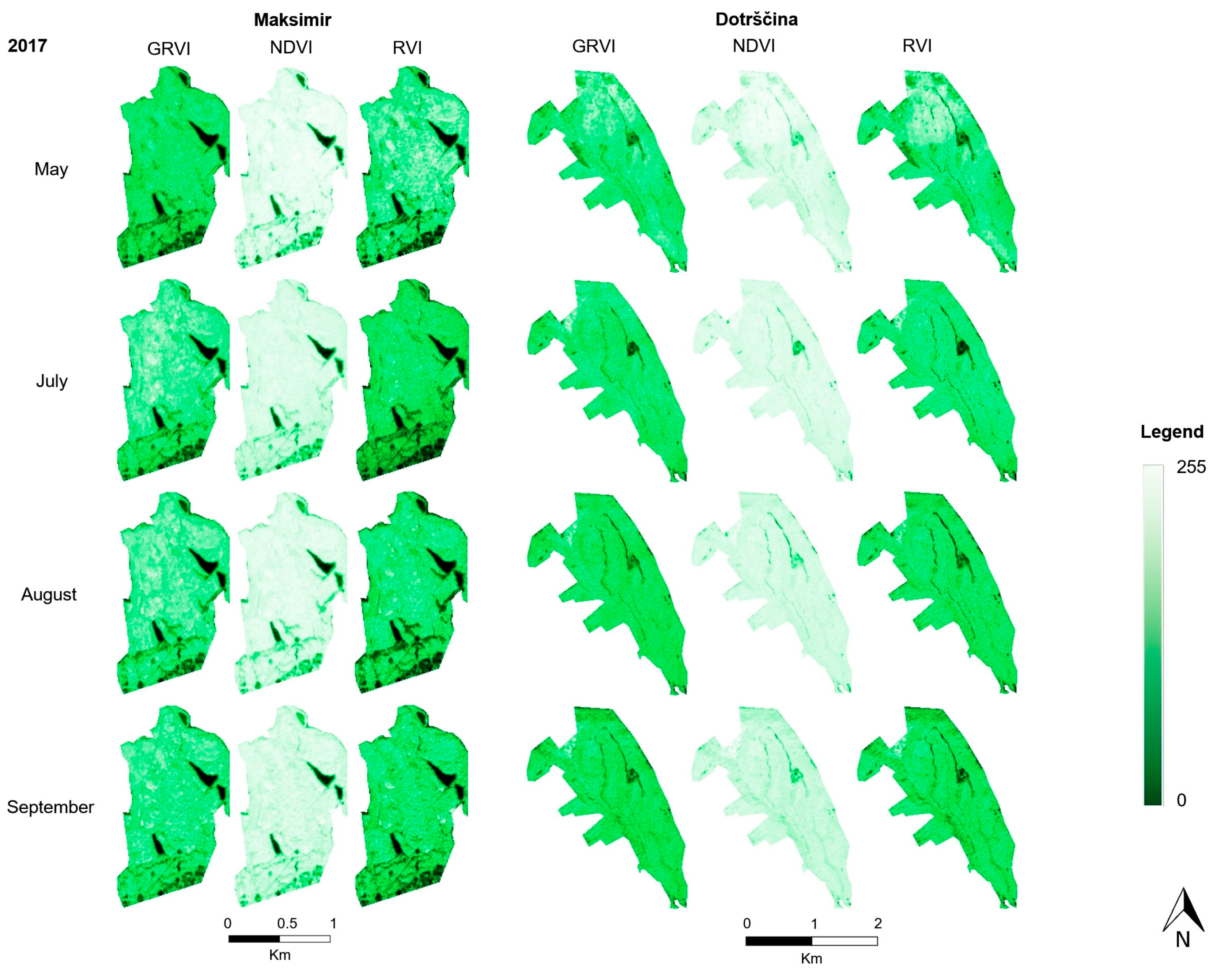

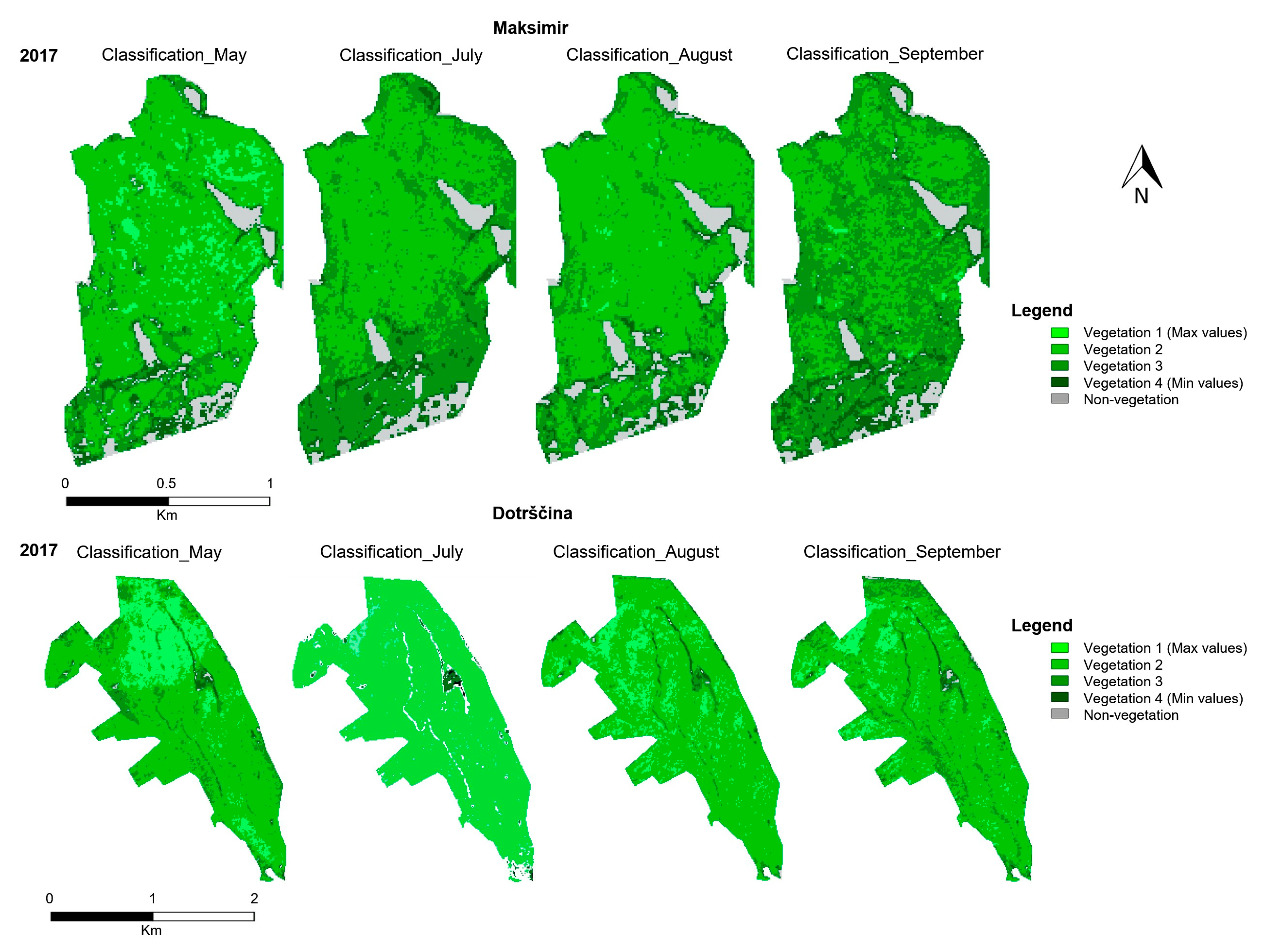


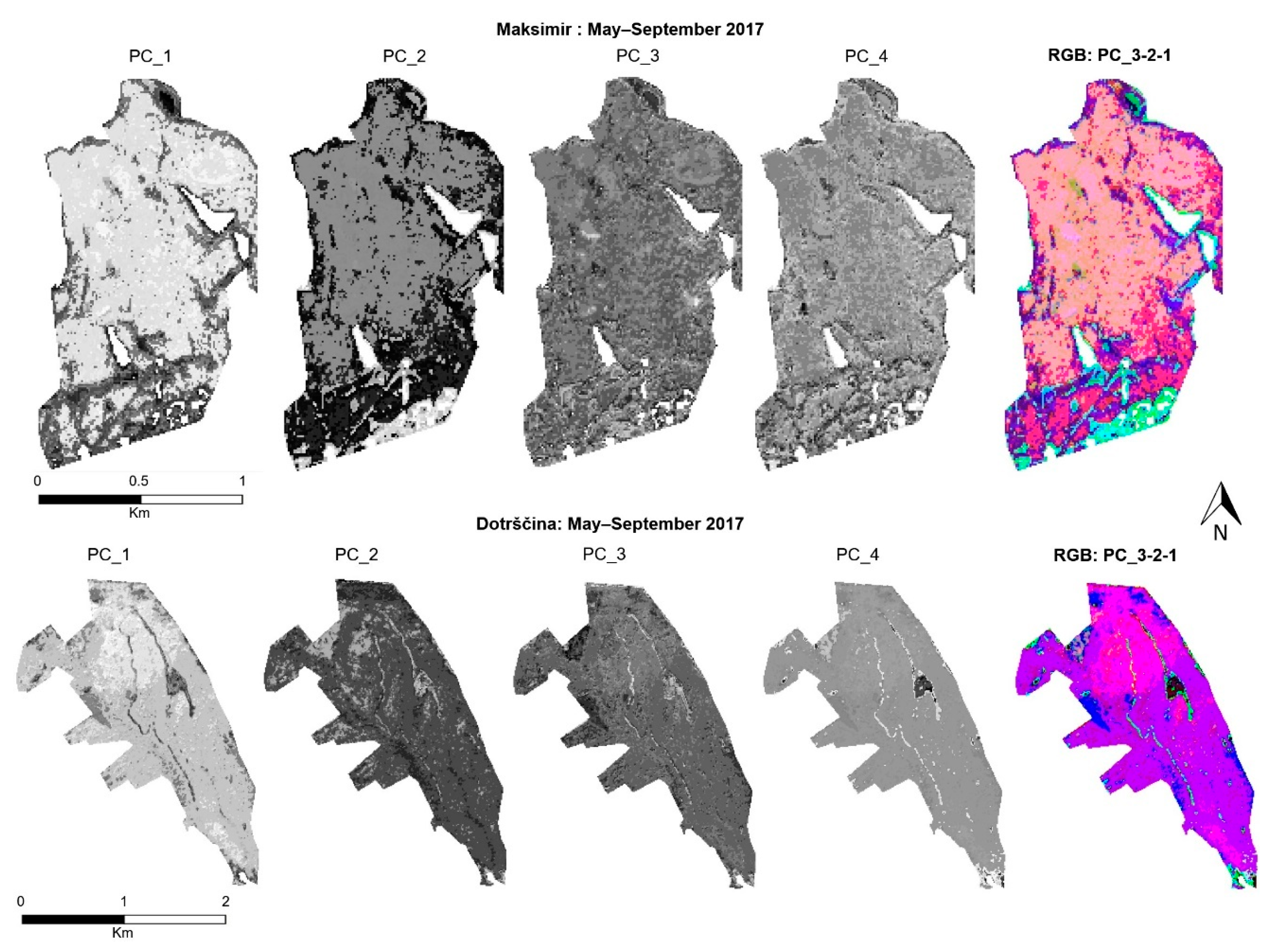
| Year | Month | Day | Satellite |
|---|---|---|---|
| 2016 | April | 26th | Sentinel-2A |
| July | 12th | Sentinel-2A | |
| August | 14th | Sentinel-2A | |
| September | 23rd | Sentinel-2A | |
| 2017 | May * | 18th | Sentinel-2A |
| July | 7th | Sentinel-2A | |
| August | 24th | Sentinel-2B | |
| September | 30th | Sentinel-2B | |
| 2018 | April | 28th | Sentinel-2B |
| July | 5th | Sentinel-2A | |
| August | 9th | Sentinel-2B | |
| September | 28th | Sentinel-2B |
| Vegetation Indices | General Formula | Formula with Sentinel-2 Bands |
|---|---|---|
| NDVI | ||
| RVI | ||
| GRVI |
| Year | Vegetation Cover (Square Kilometer) | Urban Vegetation Percentage | Urban Non-Vegetation Percentage | Percentage of Degradation |
|---|---|---|---|---|
| 2016 | 201.7 | 65.2 | 34.8 | |
| 2017 | 196.9 | 63.6 | 36.4 | 1.6 |
| 2018 | 187.7 | 60.6 | 39.4 | 3.0 |
| Year | Month | Mean Value | Min | Max | Standard Deviation | Index |
|---|---|---|---|---|---|---|
| 2016 | April | 0.790 | 0.212 | 0.911 | 0.104 | NDVI |
| July | 0.782 | 0.290 | 0.916 | 0.096 | ||
| August | 0.782 | 0.239 | 0.931 | 0.117 | ||
| September | 0.723 | 0.251 | 0.901 | 0.097 | ||
| 2017 | May | 0.803 | 0.200 | 0.918 | 0.096 | |
| July | 0.776 | 0.183 | 0.938 | 0.129 | ||
| August | 0.770 | 0.225 | 0.911 | 0.111 | ||
| September | 0.740 | 0.159 | 0.897 | 0.093 | ||
| 2018 | April | 0.828 | 0.428 | 0.929 | 0.077 | |
| July | 0.825 | 0.343 | 0.928 | 0.065 | ||
| August | 0.739 | 0.257 | 0.903 | 0.099 | ||
| September | 0.743 | 0.300 | 0.900 | 0.096 | ||
| 2016 | April | 10.450 | 1.538 | 21.588 | 4.328 | RVI |
| July | 9.648 | 1.819 | 22.811 | 3.655 | ||
| August | 10.454 | 1.630 | 27.785 | 4.625 | ||
| September | 7.014 | 1.670 | 19.267 | 2.472 | ||
| 2017 | May | 10.993 | 1.499 | 23.539 | 4.303 | |
| July | 10.791 | 1.447 | 27.542 | 5.630 | ||
| August | 9.512 | 1.582 | 21.577 | 4.079 | ||
| September | 7.560 | 1.379 | 18.408 | 2.581 | ||
| 2018 | April | 12.725 | 2.494 | 27.132 | 5.187 | |
| July | 11.651 | 2.042 | 26.913 | 3.645 | ||
| August | 7.650 | 1.693 | 19.606 | 2.823 | ||
| September | 7.776 | 1.857 | 18.970 | 2.867 | ||
| 2016 | April | 6.786 | 1.853 | 12.371 | 1.712 | GRVI |
| July | 7.249 | 2.113 | 13.737 | 2.148 | ||
| August | 7.952 | 1.891 | 17.730 | 2.830 | ||
| September | 5.757 | 1.788 | 13.018 | 1.599 | ||
| 2017 | May | 7.421 | 1.459 | 13.405 | 1.982 | |
| July | 8.797 | 1.927 | 21.262 | 3.594 | ||
| August | 7.493 | 1.775 | 15.692 | 2.444 | ||
| September | 5.930 | 1.546 | 12.210 | 1.547 | ||
| 2018 | April | 8.421 | 2.890 | 16.278 | 2.065 | |
| July | 8.261 | 2.202 | 15.194 | 2.187 | ||
| August | 5.971 | 2.076 | 12.481 | 1.742 | ||
| September | 6.238 | 2.054 | 13.952 | 1.767 |
| Maksimir–Class Coverage Statistics | ||||||||
|---|---|---|---|---|---|---|---|---|
| 2017 | May | July | August | September | ||||
| Class | Pixel | % | Pixel | % | Pixel | % | Pixel | % |
| 1 | 1336 | 7.63 | 4 | 0.02 | 80 | 0.46 | 84 | 0.48 |
| 2 | 12,410 | 70.90 | 9146 | 52.19 | 11,911 | 67.97 | 6368 | 36.35 |
| 3 | 2792 | 15.95 | 7238 | 41.30 | 5155 | 29.42 | 9286 | 53.01 |
| 4 | 965 | 5.51 | 1137 | 6.49 | 1012 | 5.77 | 1781 | 10.17 |
| Dotrščina–class coverage statistics | ||||||||
| 2017 | May | July | August | September | ||||
| Class | Pixel | % | Pixel | % | Pixel | % | Pixel | % |
| 1 | 5327 | 18.6 | 470 | 1.6 | 3767 | 13.1 | 2504 | 8.7 |
| 2 | 19,828 | 69.2 | 26,598 | 92.6 | 23,514 | 81.9 | 21,967 | 76.8 |
| 3 | 3149 | 11.0 | 1282 | 4.5 | 1109 | 3.9 | 3712 | 13.0 |
| 4 | 344 | 1.2 | 368 | 1.3 | 324 | 1.1 | 436 | 1.5 |
| Maksimir | Dotrščina | Maksimir | Dotrščina | |
|---|---|---|---|---|
| Correlation Coefficient | Percentages of Variance | |||
| PC1 | ||||
| Class_May | 0.7736 | 0.9104 | 43.0955 | 51.7349 |
| Class_July | 0.1660 | −0.3711 | 27.2206 | 27.6029 |
| Class_Aug | 0.9612 | 0.4955 | 20.0204 | 11.0605 |
| Class_Sept | 0.2106 | 0.4551 | 9.6635 | 9.6018 |
Publisher’s Note: MDPI stays neutral with regard to jurisdictional claims in published maps and institutional affiliations. |
© 2021 by the authors. Licensee MDPI, Basel, Switzerland. This article is an open access article distributed under the terms and conditions of the Creative Commons Attribution (CC BY) license (https://creativecommons.org/licenses/by/4.0/).
Share and Cite
Krtalić, A.; Linardić, D.; Pernar, R. Framework for Spatial and Temporal Monitoring of Urban Forest and Vegetation Conditions: Case Study Zagreb, Croatia. Sustainability 2021, 13, 6055. https://doi.org/10.3390/su13116055
Krtalić A, Linardić D, Pernar R. Framework for Spatial and Temporal Monitoring of Urban Forest and Vegetation Conditions: Case Study Zagreb, Croatia. Sustainability. 2021; 13(11):6055. https://doi.org/10.3390/su13116055
Chicago/Turabian StyleKrtalić, Andrija, Dario Linardić, and Renata Pernar. 2021. "Framework for Spatial and Temporal Monitoring of Urban Forest and Vegetation Conditions: Case Study Zagreb, Croatia" Sustainability 13, no. 11: 6055. https://doi.org/10.3390/su13116055
APA StyleKrtalić, A., Linardić, D., & Pernar, R. (2021). Framework for Spatial and Temporal Monitoring of Urban Forest and Vegetation Conditions: Case Study Zagreb, Croatia. Sustainability, 13(11), 6055. https://doi.org/10.3390/su13116055


