Analysis of Ownership Data from Consolidated Land Threatened by Water Erosion in the Vlára Basin, Slovakia


Abstract
1. Introduction
2. Materials and Methods
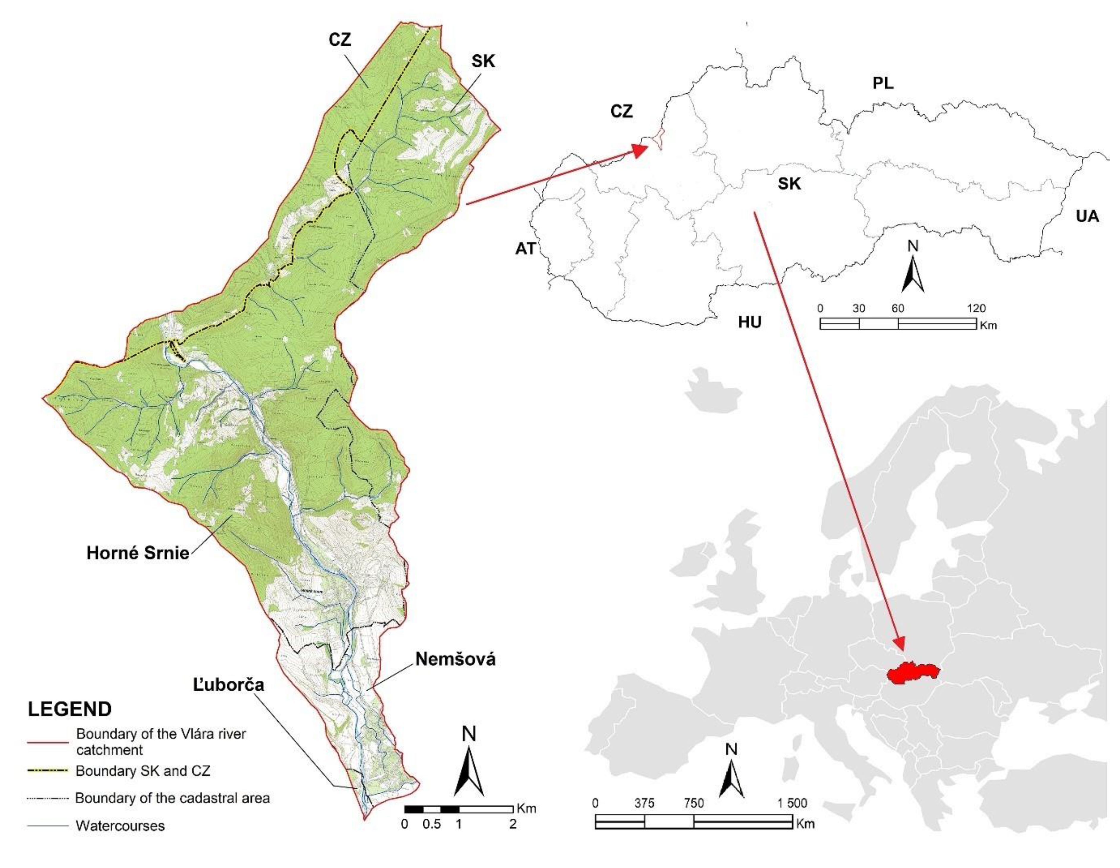
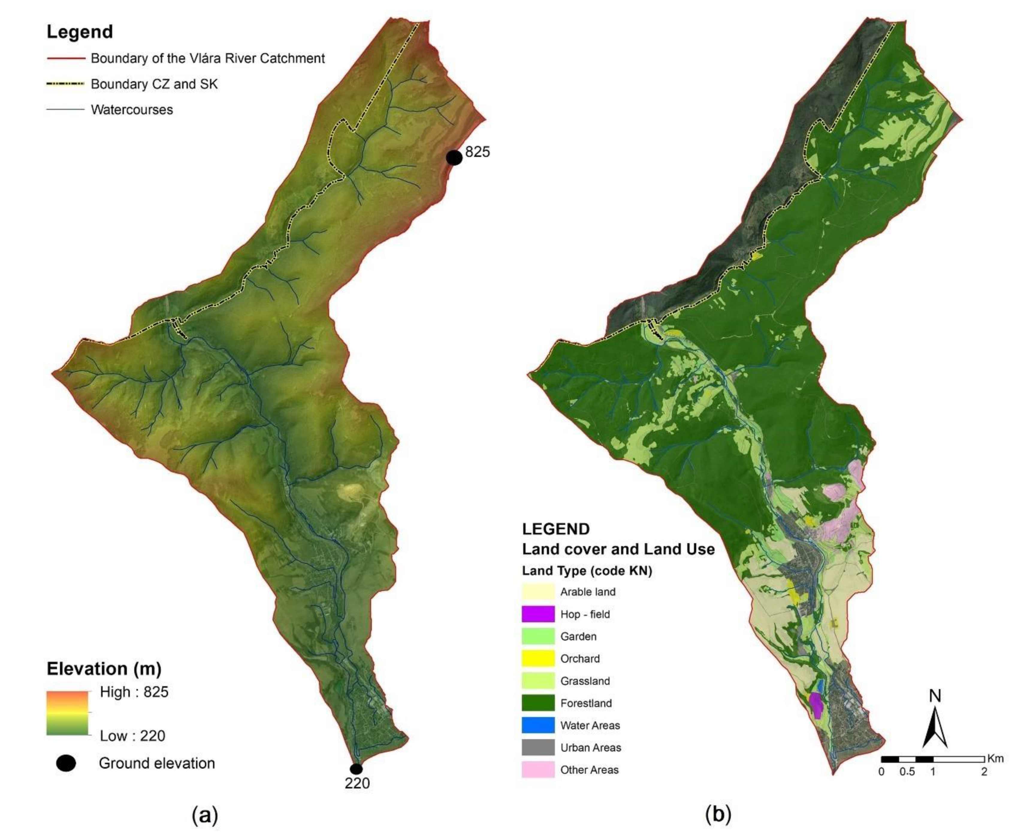
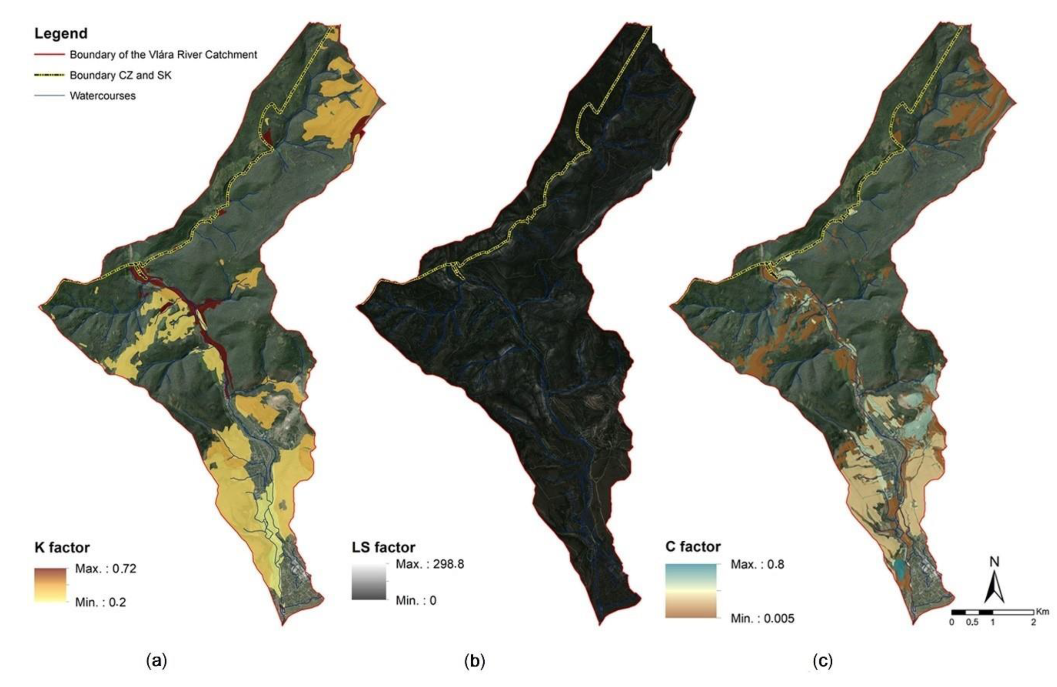
2.1. Characteristics of the Geographical Location
2.2. Data Collection and Analysis


3. Results
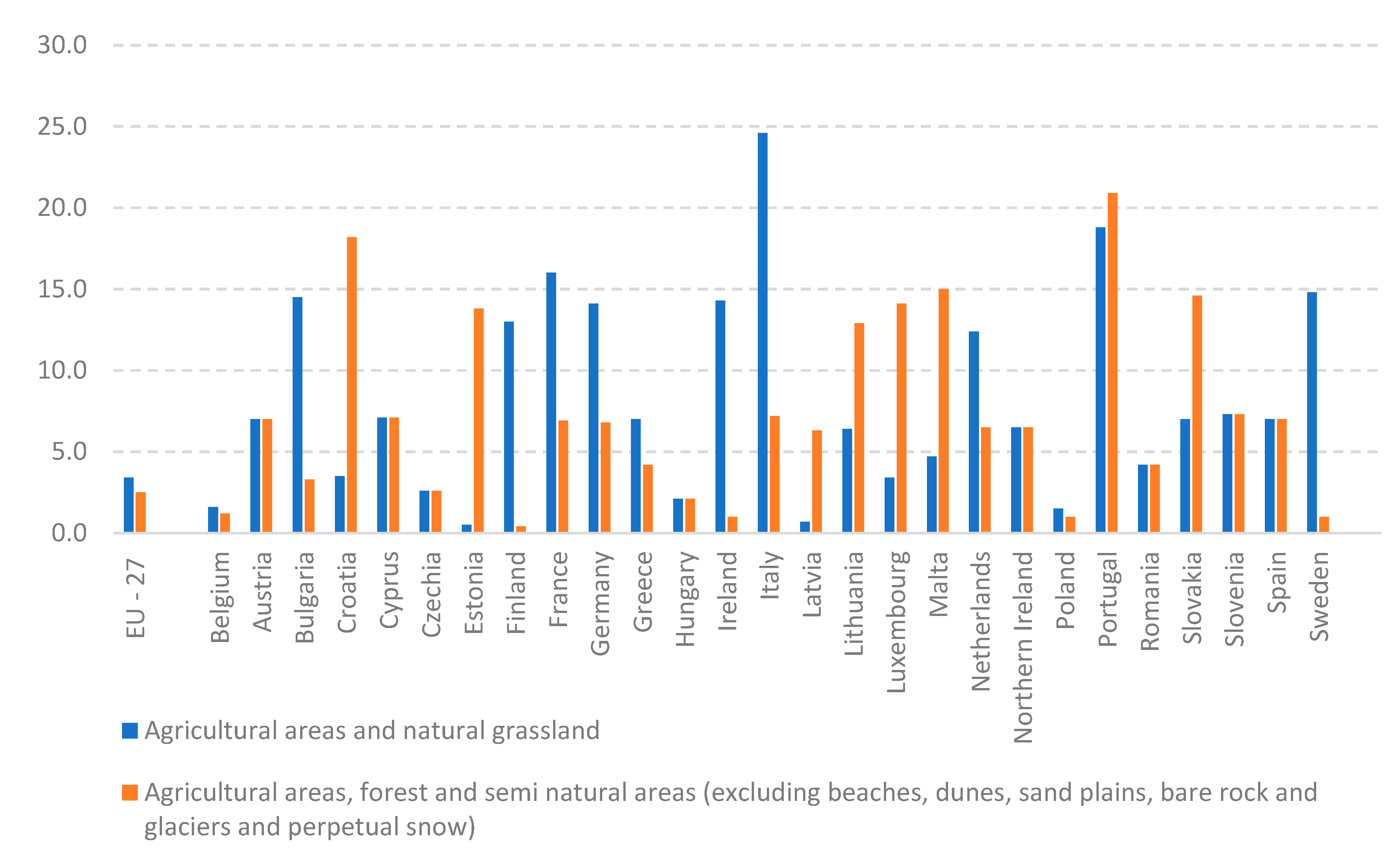
4. Discussion
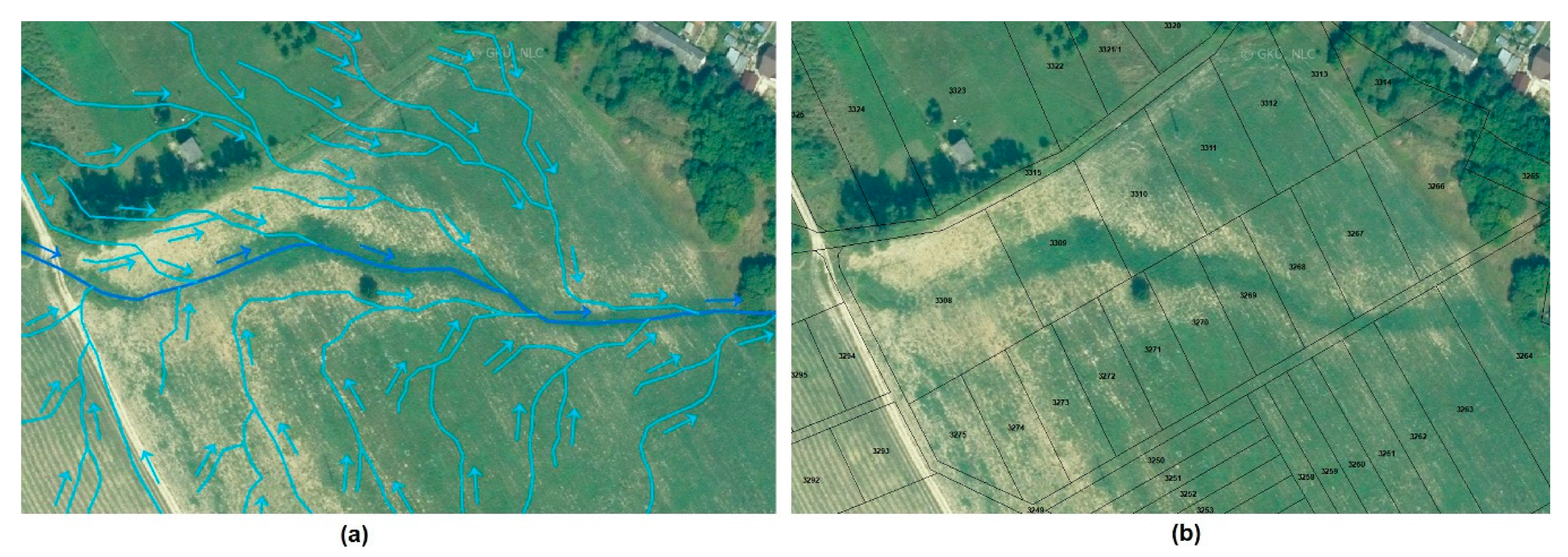
- Errors, underestimation of land consolidation design and neglecting analytical work, which seems to be a serious problem in several projects analysed by the authors, plus weak, often none/neglected control by a state authority. This problem is easy to solve. Thorough control of the entire landscaping project and subsequent implementation of measures can be achieved by the country adopting a proper framework of functional land use according to the new plan of common measures and facilities for the protection and use of the territory.
- A more serious problem is that even in the cases of correct optimization of the area in the land consolidation project, practically (in terms of land management) nothing will change, many times. Most of the landlords, as a rule, leave their land in use by the original tenants, who continue to handle the area in the usual way, disregarding the environmental measures. They manage small plots of individual owners in merged land blocks, which is the reason for the continuation of degradation processes.
5. Conclusions
Author Contributions
Funding
Institutional Review Board Statement
Informed Consent Statement
Data Availability Statement
Conflicts of Interest
References
- Wang, B.; Zheng, F.; Römkens, M.J.M.; Darboux, F. Soil erodibility for water erosion: A perspective and Chinese experiences. Geomorphology 2013, 187, 1–10. [Google Scholar] [CrossRef]
- Gruver, J.B. Prediction, Prevention and Remediation of Soil Degradation by Water Erosion. Nat. Educ. Knowl. 2013, 4, 2. [Google Scholar]
- Antal, J. Soil Erosion Protection; Slovak University of Agriculture: Nitra, Slovakia, 2005. (In Slovak) [Google Scholar]
- Midriak, R. Eroded Ruined Soils of Slovakia; Science and Research Centre—Institute of Landscape and Regional Research of Matej Bel University in Banská Bystrica: Banská Bystrica, Slovakia, 2010; p. 190. (In Slovak) [Google Scholar]
- Chen, Z.; Wang, L.; Wei, A.; Gao, J.; Lu, Y.; Zhou, J. Land-use change from arable lands to orchards reduced soil erosion and increased nutrient loss in a small catchment. Sci. Total Environ. 2019, 648, 1097–1104. [Google Scholar] [CrossRef] [PubMed]
- Borrelli, P.; Robinson, D.A.; Fleischer, L.R.; Lugato, E.; Ballabio, C.; Alewell, C.; Meusburger, K.; Modugno, S.; Schütt, B.; Ferro, V.; et al. An assessment of the global impact of 21st century land use change on soil erosion. Nat. Commun. 2017, 8, 2013. [Google Scholar] [CrossRef]
- Pena, B.S.; Abreu, M.M.; Magalhaes, M.R.; Cortez, N. Water erosion aspects of land degradation neutrality to landscape planning tools at national scale. Geoderma 2020, 363, 114093. [Google Scholar] [CrossRef]
- Panagos, P.; Ballabio, C.; Poesen, J.; Lugato, E.; Scarpa, S.; Montanarella, L.; Borrelli, P. A Soil Erosion Indicator for Supporting Agricultural, Environmental and Climate Policies in the European Union. Remote Sens. 2020, 12, 1365. [Google Scholar] [CrossRef]
- Covelli, C.; Cimorelli, L.; Pagliuca, D.N.; Molino, B.; Pianese, D. Assessment of Erosion in River Basins: A Distributed Model to Estimate the Sediment Production over Watersheds by a 3-Dimensional LS Factor in RUSLE Model. Hydrology 2020, 7, 13. [Google Scholar] [CrossRef]
- Wei, L.; Luo, Y.; Wang, M.; Su, S.; Pi, J.; Li, G. Essential fragmentation metrics for agricultural policies: Linking landscape pattern, ecosystem service and land use management in urbanizing China. Agric. Syst. 2020, 182, 102833. [Google Scholar] [CrossRef]
- Čimo, J.; Aydin, E.; Šinka, K.; Tárník, A.; Kišš, V.; Halaj, P.; Toková, L.; Kotuš, T. Change in the Length of the Vegetation Period of Tomato (Solanum lycopersicum L.), White Cabbage (Brassica oleracea L. var. capitata) and Carrot (Daucus carota L.) Due to Climate Change in Slovakia. Agronomy 2020, 10, 1110. [Google Scholar] [CrossRef]
- Li, Z.; Fang, H. Impacts of climate change on water erosion: A review. Earth-Sci. Rev. 2016, 163, 94–117. [Google Scholar] [CrossRef]
- Wischmeier, W.H.; Smith, D.D. Predicting Rainfall Erosion Losses—A Guide to Conservation Planning. In Agricultural Handbook; U. S. Department of Agriculture: Hyatsville, MD, USA, 1978; No. 537; p. 58. [Google Scholar]
- Renard, K.G.; Foster, G.R.; Weesier, G.A.; Mccool, D.K.; Yoder, D.C. Predicting Soil Erosion by Water: A Guide to Conservation Planning with the Revised Universal Soil Loss Equation (RUSLE); United States Department of Agriculture: Washington, DC, USA, 1997; p. 407.
- Maqsoom, A.; Aslam, B.; Hassan, U.; Kazmi, Z.A.; Sodangi, M.; Tufail, R.F.; Farooq, D. Geospatial Assessment of Soil Erosion Intensity and Sediment Yield Using the Revised Universal Soil Loss Equation (RUSLE) Model. ISPRS Int. J. Geo-Inf. 2020, 9, 356. [Google Scholar] [CrossRef]
- Lense, G.H.E.; Moreira, R.S.; Parreiras, T.C.; Santana, D.B.; Bolello, T.d.M.; Mincato, R.L. Water erosion modeling by the Erosion Potential Method and the Revised Universal Soil Loss Equation: A comparative analysis. Rev. Ambiente Água 2020, 15, e2501. [Google Scholar] [CrossRef]
- Efthimiou, N.; Lykoudi, E.; Karavitis, C. Comparative analysis of sediment yield estimations using different empirical soil erosion models. Hydrol. Sci. J. 2017, 62, 2674–2694. [Google Scholar] [CrossRef]
- Sakuno, N.R.R.; Guiçardi, A.C.F.; Spalevic, V.; Avanzi, J.C.; Silva, M.L.N.; Mincato, R.L. Adaptation and application of the erosion potential method for tropical soils. Rev. Ciência Agronômica 2020, 51, e20186545. [Google Scholar] [CrossRef]
- Balasubramani, K. Estimation of soil erosion in a semi-arid watershed of Tamil Nadu (India) using revised universal soil loss equation (rusle) model through GIS. Model. Earth Syst. Environ. 2015, 1, 10. [Google Scholar] [CrossRef]
- Jiang, L.; Yao, Z.; Wu, S.; Wang, R.; Wang, L. Estimation of soil erosion in some sections of Lower Jinsha River based on RUSLE. Nat. Hazards 2015, 76, 1831–1847. [Google Scholar] [CrossRef]
- Alewell, C.H.; Borrelli, P.; Meusburger, K.; Panagos, P. Using the USLE: Chances, challenges, and limitations of soil erosion modelling. Int. Soil Water Conserv. Res. 2019, 7, 203–225. [Google Scholar] [CrossRef]
- Estimated Soil Loss by Water Erosion by Land Cover Type. 2020. Available online: http://ec.europa.eu/eurostat/data/database (accessed on 20 August 2020).
- VUPOP 36. Proceedings of Soil Science and Conservation Researcg Institute; Slovak publishing house of agricultural literature: Bratislava, Slovakia, 2014; p. 168. ISBN 978-80-8163-007-1. (In Slovak) [Google Scholar]
- Hucko, P. Sediments in the reservoirs in the Slovak Republic. In Proceedings of the Conference Drinking Water; W&ET Team, Č.: Budějovice, Czech Republic, 2016; pp. 33–44, ISBN 978-80-905238-2-1. (In Slovak). [Google Scholar]
- Petrovič, F.; Stranovský, P.; Muchová, Z.; Falťan, V.; Skokanová, H.; Havlíček, M.; Gabor, M.; Špulerová, J. Landscape-ecological optimization of hydric potential in foothills region with dispersed settlements. A case study of Nova Bosaca, Slovakia. Appl. Ecol. Environ. Res. 2017, 15, 379–400. [Google Scholar] [CrossRef]
- Antal, J.; Streďanský, J.; Streďanská, A.; Tátošová, L.; Lackóová, L. Soil Protection and Fertilization; SPU: Nitra, Slovakia, 2014; p. 210. ISBN 978-80-552-1205-0. (In Slovak) [Google Scholar]
- Act 220/2004 Coll. on the Protection and Use of Agricultural Land and Amending Act no. 245/2003 Coll. on Integrated Prevention and Control of Environmental Pollution and on Amendments to Certain Acts. Available online: https://www.zakonypreludi.sk/zz/2004-220 (accessed on 20 August 2020). (In Slovak).
- Muchová, Z.; Raškovič, V. Fragmentation of land ownership in Slovakia: Evolution, context, analysis, and possible solutions. Land Use Policy 2020, 95, 104644. [Google Scholar] [CrossRef]
- Pagáč, J.; Konc, L.; Mokrá, A. Categorization of the districts of the Slovak Republic in term of fragmentation in land ownership. In SGEM, 1st ed.; STEP92 Technology, 1012 s.; SGEM: Sofia, Bulgaria, 2019; pp. 85–94. ISBN 978-619-7408-86-7. [Google Scholar]
- Urban, J.; Hudecová, Ľ.; Muchová, Z.; Pauditšová, E.; Julény, A.; Uhlík, V. Slovakia. Country of Unknown Owners. Resolution of Land Ownership by Land Consolidation. Slovak Chamber of Land Consolidation; Bratislava, Slovakia, 2019; p. 125. Available online: http://www.kpu.sk/sites/default/files/slovensko_-_krajina_neznamych_vlastnikov_3_sk5.pdf (accessed on 21 March 2020). (In Slovak)
- Muchová, Z.; Tárniková, M.; Petrovič, F. Elimination of the fragmentation of land ownership as a initiative for positive changes in a country, specific (implemented) example—Veľké Vozokany (Slovakia) project area. In SGEM, 1st ed.; STEP92 Technology; SGEM: Sofia, Bulgaria, 2014; pp. 239–246. ISBN 978-619-7105-11-7. [Google Scholar]
- Beltramo, R.; Rostagno, A.; Bonadonna, A. Land Consolidation Associations and the Management of Territories in Harsh Italian Environments: A Review. Resources 2018, 7, 19. [Google Scholar] [CrossRef]
- Mansberger, R.; Seher, W. Land administration and land consolidation as part of Austrian land management. EU Agrar. Law 2017, 6, 68–76. [Google Scholar] [CrossRef][Green Version]
- Krupowicz, W.; Czarnecka, A.; Grus, M. Implementing crowdsourcing initiatives in land consolidation procedures in Poland. Land Use Policy 2020, 99, 105015. [Google Scholar] [CrossRef]
- Jürgenson, E. Land reform, land fragmentation and perspectives for future land consolidation in Estonia. Land Use Policy 2016, 57, 34–43. [Google Scholar] [CrossRef]
- Hendricks, A.; Lisec, A. Land consolidation for large-scale infrastructure projects in Germany. Geod. Vestn. 2014, 58, 46–68. [Google Scholar] [CrossRef]
- Demetriou, D.; Stillwell, J.; See, L.M. Land consolidation in Cyprus: Why is an Integrated Planning and Decision Support System required? Land Use Policy 2012, 29, 131–142. [Google Scholar] [CrossRef]
- Lisec, A.; Primožič, T.; Ferlan, M.; Šumrada, R.; Drobne, S. Land owners’ perception of land consolidation and their satisfaction with the results—Slovenian experiences. Land Use Policy 2014, 38, 550–563. [Google Scholar] [CrossRef]
- Elvestad, H.E.; Sky, P.K. Efects of Land Consolidation in Norway. Nord. J. Surv. Real Estate Res. 2019, 14, 64–78. [Google Scholar]
- Hartvigsen, M. Land consolidation and land banking in Denmark—Tradition, multi-purpose, and perspectives. Dan. J. Geoinform. Land Manag. 2014, 47, 51–73. [Google Scholar]
- Sulonen, K.; Kotilainen, S. Lessor’s Status in land consolidation in Finland. Nord. J. Surv. Real Estate Res. 2016, 11, 18–36. [Google Scholar]
- Janus, J.; Markuszewska, I. Forty years later: Assessment of the long-lasting effectiveness of land consolidation projects. Land Use Policy 2019, 83, 22–31. [Google Scholar] [CrossRef]
- Jusková, K.; Muchová, Z. Land consolidation as an instrument for land ownerschip defragmentation in the Czech Republic and Slovakia. In MendelNet, 1st ed.; MendelNet, Mendelova Univerzita: Brno, Czech Republic, 2013; p. 959. ISBN 978-80-7375-908-7. [Google Scholar]
- Zoning Plan of the City Nemšová 2018. Available online: https://www.nemsova.sk/na-stiahnutie/subory/7/upn-m-nemsova--zavazna-cistopis.pdf (accessed on 10 June 2020). (In Slovak).
- Zoning Plan of the Village Horné Srnie 2008. Available online: https://www.hornesrnie.sk/sk/wp-content/subory/2012/10/Sprievodna_sprava.pdf (accessed on 10 June 2020). (In Slovak).
- Majský, J.; Mertanová, S.; Hauk, R. Vlára, a Territory of European Importance; State Nature Protection of the Slovak Republic: Banská Bystrica, Slovakia, 2015; ISBN 978-80-89802-47-0. (In Slovak) [Google Scholar]
- Janeček, M. Protection of Agricultural Land from Erosion; VÚMOP: Praha, Czech Republic, 2007; p. 76s. ISBN 978-80-254-09732. (In Czech) [Google Scholar]
- Janeček, M. Protection of Agricultural Land from Erosion. Methodology; ČZU: Praha, Czech Republic, 2012; ISBN 978-80-87415429. (In Czech) [Google Scholar]
- Decree, no. 59/2013 Coll., Amending Decree no. 508/2004 Coll. and Which Implements Act no. 220/2004 Coll. on the Protection and Use of Agricultural Land and Amending Act no. 245/2003 Coll. on Integrated Prevention and Control of Environmental Pollution and on Amendments to Certain Acts. Available online: https://www.slov-lex.sk/pravne-predpisy/SK/ZZ/2013/59/vyhlasene_znenie.html (accessed on 20 August 2020). (In Slovak).
- Ilavská, B.; Jambor, P.; Lazúr, R. Identification of Threats to Soil Quality due to Water and Wind Erosion and Proposal of Measures; VÚPOP: Bratislava, Slovakia, 2005; p. 60. (In Slovak) [Google Scholar]
- Šurda, P.; Šimonides, I.; Antal, J. A determination of area of potential erosion by geographic information system. J. Environ. Eng. Landsc. Manag. 2007, 15, 144–152. [Google Scholar] [CrossRef]
- Alena, F. Determination of Soil Loss by Erosive Runoff for the Design of Erosion Control Measures: Methodological aid; ŠMS: Bratislava, Slovakia, 1986; p. 58. (In Slovak) [Google Scholar]
- STN 75 4501:2000: Hydromelioration. Erosion Protection of Agricultural Land. Basic Provisions; Slovak Office of Standards: Metrology and Testing, Bratislava, 2000. (In Slovak)
- ZBGIS. Available online: https://zbgis.skgeodesy.sk/ (accessed on 15 January 2020).
- Zhang, Y.; Jin, R.; Zhu, W.; Zhang, D.; Zhang, X. Impacts of Land Use Changes on Wetland Ecosystem Services in the Tumen River Basin. Sustainability 2020, 12, 9821. [Google Scholar] [CrossRef]
- Igaz, D.; Bárek, V.; Halaj, P.; Takáč, J.; Čimo, J. A comparison of measured soil moisture with simulated results obtained by selected models for Danubian lowland. Cereal Res. Commun. 2008, 36, 1619–1622. [Google Scholar]
- Sumfleth, B.; Majer, S.; Thrän, D. Recent Developments in Low iLUC Policies and Certification in the EU Biobased Economy. Sustainability 2020, 12, 8147. [Google Scholar] [CrossRef]
- Csikos, N.; Schwanebeck, M.; Kuhwald, M.; Szilassi, P.; Duttmann, R. Density of Biogas Power Plants as An Indicator of Bioenergy Generated Transformation of Agricultural Landscapes. Sustainability 2020, 11, 2500. [Google Scholar] [CrossRef]
- Jurík, L.; Hubačíková, V.; Pokrývková, J. Soil erosion—Environmental and economic context. In Management; Bookman: Prešov, Slovakia, 2018; pp. 625–630. ISBN 978-80-8165-301-8. [Google Scholar]
- Heidi, L.; Marianne, P.; Klaus, S. Do farmers care about rented land? A multi-method study on land tenure and soil conservation. Land Use Policy 2019, 82, 228–239. [Google Scholar]
- Schwilch, G.; Lemann, T.; Berglund, Ö.; Camarotto, C.; Cerdà, A.; Daliakopoulos, I.N.; Kohnová, S.; Krzeminska, D.; Marañón, T.; Rietra, R.; et al. Assessing Impacts of Soil Management Measures on Ecosystem Services. Sustainability 2020, 10, 4416. [Google Scholar] [CrossRef]
- FAO. Available online: http://www.fao.org/home/en/ (accessed on 15 July 2020).
- Rapsomanikis, G. The Economic Lives of Smallholder Farmers. An Analysis Based on Household Data from Nine Countries; Food and Agriculture Organization of the United Nations (FAO): Rome, Italy, 2015. [Google Scholar]
- Azadi, H.; Vanhaute, E.; Janečková, K.; Sklenička, P.; Teklemariam, D.; Feng, L.; Witlox, F. Evolution of land distribution in the context of development theories. Land Use Policy 2020, 97, 104730. [Google Scholar] [CrossRef]
- Walmsley, A.; Azadi, H.; Tomeckova, K.; Sklenicka, P. Contrasting effects of land tenure on degradation of Cambisols and Luvisols: The case of Central Bohemia Region in the Czech Republic. Land Use Policy 2020, 99, 104956. [Google Scholar] [CrossRef]
- Uchiyama, Y.; Kohsaka, R. Access and Use of Green Areas during the COVID-19 Pandemic: Green Infrastructure Management in the “New Normal”. Sustainability 2020, 12, 9842. [Google Scholar] [CrossRef]


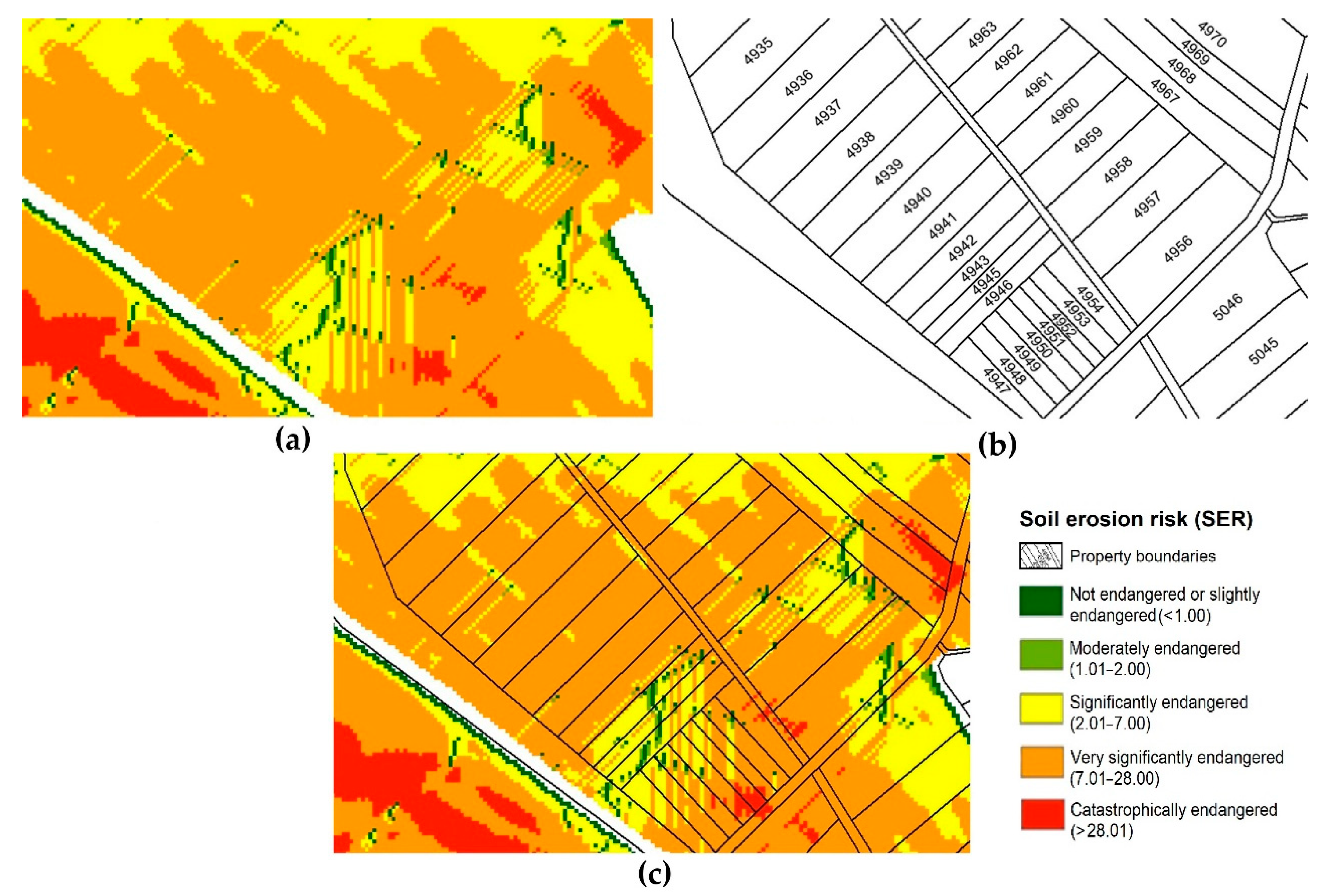
| Soil Erosion Risk (SER) | Name of Soil Endangered by Erosion | Land Area (ha) | Land Area (%) |
|---|---|---|---|
| <1.00 | Unaffected or slightly endangered | 592.03 | 87.50 |
| 1.01–2.00 | Moderately endangered | 18.57 | 2.74 |
| 2.01–7.00 | Significantly endangered | 24.36 | 3.60 |
| 7.01–28.00 | Very significantly endangered | 35.65 | 5.27 |
| ˃28.01 | Catastrophically endangered | 5.92 | 0.88 |
| Category Soil Endangered | Mean Value Loss of Soil (t. ha −1. Year −1) | Land Area (ha) | Calculated Loss of Soil (t. Year−1) | Calculated Loss of Soil (%) |
|---|---|---|---|---|
| <1.00 | 1.03 | 592.03 | 609.65 | 36.13 |
| 1.01–2.00 | 8.03 | 18.57 | 149.06 | 8.83 |
| 2.01–7.00 | 7.08 | 24.36 | 172.46 | 10.22 |
| 7.01–28.00 | 14.25 | 35.65 | 508.13 | 30.12 |
| >28.01 | 41.87 | 5.92 | 247.89 | 14.69 |
| Together | 1687.18 | 100 |
| Ownership | Nemšová | Ľuborča | Horné Srnie | |||
|---|---|---|---|---|---|---|
| ha | % | ha | % | ha | % | |
| Municipal | 17.21 | 6.35 | 0.57 | 5.45 | 27.90 | 2.14 |
| State | 35.19 | 12.98 | 2.93 | 28.01 | 584.50 | 44.83 |
| Church | 9.45 | 3.49 | 1.07 | 10.23 | 3.85 | 0.29 |
| Private | 127.21 | 46.94 | 1.24 | 11.85 | 461.37 | 35.39 |
| Vlára Agricultural Cooperative | 1.30 | 0.48 | - | - | 0.74 | 0.06 |
| Slovak Road Authority | 0.44 | 0.16 | - | - | - | - |
| Community of Former Landowners and Foresters | 41.37 | 15.26 | - | - | - | - |
| SPP—distribúcia, a. s. | 0.06 | 0.02 | - | - | - | - |
| Západoslovenská distribúcia, a. s. | 0.01 | 0.005 | - | - | - | - |
| Czech Republic Forests | - | - | - | - | 19.61 | 1.50 |
| Slovak Republic Forests | - | - | - | - | 0.01 | 0.001 |
| Brumov Civic Reservation | - | - | - | - | 6.12 | 0.47 |
| Sidónie Pasture Cooperative | - | - | - | - | 0.40 | 0.03 |
| RST GLOB s. r. o. | - | - | - | - | 1.14 | 0.09 |
| Slovenský vodohospodársky podnik, š. p. | 1.84 | 0.68 | - | - | - | - |
| NEMŠOVÁ | ||||||||||||||||
|---|---|---|---|---|---|---|---|---|---|---|---|---|---|---|---|---|
| Owners | Land Area (ha) | Number of Plots | ||||||||||||||
| Category SER | 1 | 2 | 3 | 4 | 5 | 1 | 2 | 3 | 4 | 5 | 1 | 2 | 3 | 4 | 5 | |
| Private | 477 | 39 | 24 | 11 | - | 112.20 | 7.33 | 5.41 | 2.27 | - | 648 | 40 | 28 | 16 | - | |
| State | Unknow owners | 130 | 7 | 2 | - | - | 28.47 | 0.80 | 0.45 | - | - | 145 | 7 | 2 | - | - |
| Slovak Republic (SR) | 1 | 1 | - | - | - | 0.11 | 5.36 | - | - | - | 10 | 1 | - | - | - | |
| Municipal | 1 | 1 | - | 1 | - | 16.52 | 0.64 | - | 0.05 | - | 62 | 4 | - | 2 | - | |
| Vlára Agricultural Cooperative | 1 | 1 | - | - | - | 1.30 | 0.56 | - | - | - | 6 | 2 | - | - | - | |
| Church | 1 | - | 1 | 1 | - | 5.28 | - | 4.08 | 0.09 | - | 5 | - | 1 | 2 | - | |
| Slovak Road Authority | 1 | - | - | - | - | 0.44 | - | - | - | - | 9 | - | - | - | - | |
| Community of Former Landowners and Foresters | 1 | - | - | - | - | 41.37 | - | - | - | - | 27 | - | - | - | - | |
| SPP—distribúcia, a. s. | 1 | - | - | - | - | 0.06 | - | - | - | - | 2 | - | - | - | - | |
| Západoslovenská distribúcia, a. s. | 1 | - | - | - | - | 0.01 | - | - | - | - | 6 | - | - | - | - | |
| ĽUBORČA | ||||||||||||||||
| Owners | Land Area (ha) | Number of Plots | ||||||||||||||
| Category SER | 1 | 2 | 3 | 4 | 5 | 1 | 2 | 3 | 4 | 5 | 1 | 2 | 3 | 4 | 5 | |
| Private | 2 | 1 | - | - | - | 1.18 | 0.06 | - | - | - | 2 | 1 | - | - | - | |
| State | Unknow owners | 1 | - | - | - | - | 2.93 | - | - | - | - | 8 | - | - | - | - |
| SR | - | - | - | - | - | - | - | - | - | - | - | - | - | - | - | |
| Municipal | 1 | 1 | - | - | - | 0.51 | 0.06 | - | - | - | 1 | 1 | - | - | - | |
| Slovenský vodohospodársky podnik | 1 | 1 | - | - | - | 1.53 | 0.31 | - | - | - | 1 | 1 | - | - | - | |
| Church | 1 | - | - | - | - | 1.07 | - | - | - | - | 4 | - | - | - | - | |
| HORNÉ SRNIE | ||||||||||||||||
| Owners | Land Area (ha) | Number of Plots | ||||||||||||||
| Category SER | 1 | 2 | 3 | 4 | 5 | 1 | 2 | 3 | 4 | 5 | 1 | 2 | 3 | 4 | 5 | |
| Private | 654 | 87 | 138 | 163 | 11 | 324.53 | 60.52 | 23.15 | 52.17 | 1.00 | 1288 | 94 | 155 | 204 | 12 | |
| State | Unknow owners SR | 398 | 29 | 37 | 37 | 2 | 80.71 | 3.95 | 6.39 | 5.70 | 0.31 | 501 | 29 | 38 | 38 | 2 |
| Unknow owners Czech (CZ) | 1 | - | - | - | - | 1.60 | - | - | - | - | 3 | - | - | - | - | |
| SR | 1 | 1 | 1 | 1 | - | 350.15 | 8.27 | 2.59 | 126.43 | - | 82 | 4 | 6 | 6 | - | |
| Municipal | 1 | 1 | 1 | 1 | 1 | 20.88 | 0.31 | 2.46 | 3.98 | 0.27 | 94 | 3 | 15 | 19 | 2 | |
| Czech Republic Forests | 1 | - | - | - | - | 19.61 | - | - | - | - | 6 | - | - | - | - | |
| Slovak Republic Forests | 1 | - | 1 | 1 | - | 0.01 | - | - | - | - | 1 | - | - | - | - | |
| Brumov Civic Reservation | 1 | - | - | - | - | 0.07 | - | - | - | - | 1 | - | - | - | - | |
| Sidónie Pasture Cooperative | 1 | - | - | - | - | 6.12 | - | - | - | - | 4 | - | - | 2 | - | |
| Vlára Agricultural Cooperative | 1 | - | - | 1 | - | 0.40 | - | - | 0.34 | - | 3 | - | - | 2 | - | |
| Church | 1 | - | - | - | - | 3.85 | - | - | - | - | 8 | - | - | - | - | |
| RST GLOB s. r. o. | 1 | - | - | - | - | 1.14 | - | - | - | - | 1 | - | - | - | - | |
| SER | Nemšová | Ľuborča | Horné Srnie |
|---|---|---|---|
| Unaffected or slightly endangered | 615 | 12 | 1062 |
| Moderately endangered | 49 | 13 | 118 |
| Significantly endangered | 27 | 177 | |
| Very significantly endangered | 13 | 202 | |
| Catastrophically endangered | 14 |
Publisher’s Note: MDPI stays neutral with regard to jurisdictional claims in published maps and institutional affiliations. |
© 2020 by the authors. Licensee MDPI, Basel, Switzerland. This article is an open access article distributed under the terms and conditions of the Creative Commons Attribution (CC BY) license (http://creativecommons.org/licenses/by/4.0/).
Share and Cite
Pagáč Mokrá, A.; Pagáč, J.; Muchová, Z.; Petrovič, F. Analysis of Ownership Data from Consolidated Land Threatened by Water Erosion in the Vlára Basin, Slovakia. Sustainability 2021, 13, 51. https://doi.org/10.3390/su13010051
Pagáč Mokrá A, Pagáč J, Muchová Z, Petrovič F. Analysis of Ownership Data from Consolidated Land Threatened by Water Erosion in the Vlára Basin, Slovakia. Sustainability. 2021; 13(1):51. https://doi.org/10.3390/su13010051
Chicago/Turabian StylePagáč Mokrá, Alexandra, Jakub Pagáč, Zlatica Muchová, and František Petrovič. 2021. "Analysis of Ownership Data from Consolidated Land Threatened by Water Erosion in the Vlára Basin, Slovakia" Sustainability 13, no. 1: 51. https://doi.org/10.3390/su13010051
APA StylePagáč Mokrá, A., Pagáč, J., Muchová, Z., & Petrovič, F. (2021). Analysis of Ownership Data from Consolidated Land Threatened by Water Erosion in the Vlára Basin, Slovakia. Sustainability, 13(1), 51. https://doi.org/10.3390/su13010051