Essay

Identification of Priority Conservation Areas for Protected Rivers Based on Ecosystem Integrity and Authenticity: A Case Study of the Qingzhu River, Southwest China

1
School of Business and Tourism Management, Yunnan University, Kunming 650500, China
2
National Park Administration of China, National Forestry and Grassland Administration, Planning and Research Center of National Park, Kunming 650216, China
3
United States Department of Agriculture, Forest Server, Rocky Mountain Research Station, Aldo Leopold Wilderness Research Institute, Missoula, MT 59801, USA
4
School of Architecture and Planning, Yunnan University, Kunming 650500, China
5
Yunnan Meteorological Service, Kunming 650034, China
*
Author to whom correspondence should be addressed.
Sustainability 2021, 13(1), 323; https://doi.org/10.3390/su13010323
Submission received: 2 December 2020 / Revised: 23 December 2020 / Accepted: 25 December 2020 / Published: 31 December 2020
(This article belongs to the Special Issue Durable Protections for Free-Flowing Rivers)

Abstract

:
The establishment of protected areas for a river (PARs) is an efficient approach for the conservation of its ecosystem and biodiversity. This study selected the free-flowing Qingzhu River, located in the mountains of southwest China and one of 34 global biodiversity hotspots, as a case study. This study applied the ecosystem approach to develop a model for identifying priority conservation areas for a river (PCARs) based on integrity and authenticity. Three model elements were selected, namely streams, forest and human activity, characterized by three indicators: irreplaceability, tree cover and human activity, respectively. The spatial distributions of these indicators were overlaid according to different weights to generate a map (SCPV) of comprehensive protected value (CPV), which was used to indicate ecosystem integrity and authenticity in the study catchment. Lastly, PCARs were identified by comparing existing protected areas with the calculated SCPV. The application of the model to the Qingzhu River indicated the area of PCARs to be ~71.88 km2, accounting for 15.13% of the total PAR area. Priority reaches for protection were then identified, with many falling within the mainstem of the river in the middle and lower reaches. The total length of priority protected reaches was ~75.97 km, accounting for 49.33% of the total length of the river mainstem within Qingchuan County. This study validated the model at both the theoretical and practical level, confirming that the model is useful for facilitating the precise protection and smart management of rivers.

1. Introduction

The establishment of protected areas (PAs) is crucial for facilitating the protection of biodiversity, maintaining global ecological security and promoting sustainable development [1,2,3]. The spatial identification of PAs is a core issue within the planning and construction of PAs, and involves the identification of three basic elements of PAs: (1) the features of an ecosystem that need protection; (2) the location of the area that needs protection and; (3) appropriate methods to protect the ecosystem [4]. More importantly, the key aims for the establishment of PAs are the maintenance of ecosystem integrity and authenticity [4,5], and these aims also determine the criteria for the site selection of PAs. Regardless of type, PAs are generally characterized by maintenance of a natural state without human influence, particularly for nature reserves [5]. Therefore, ecosystem integrity and authenticity should be considered within the selection of sites for the establishment of PAs.
At present, existing studies on the identification of sites for the establishment of PAs generally fall into three categories: (1) the identification of priority conservation areas (PCAs) [6,7]; (2) the delineation of PAs [8,9] and; (3) functional zoning [10,11]. The identification of PCAs involves the identification of areas with ecological value that would form the core areas of PAs, and the protection of PCAs would aim to maximize available resources to minimize the degree of biodiversity loss [4,12]. Therefore, the identification of PCAs is an important prerequisite for the construction of PAs.
Important criteria for the identification of PCAs include uniqueness of the natural environment, degree of vulnerability of the area and the practicality of protection measures [4]. Recent studies on PCAs have mainly focused on characterizing the various ecosystems, selecting areas with rich biodiversity as conservation priorities. The many typical past studies on PCAs include spatial prioritization for the global conservation of species based on niche environments [13], identification of cost-effective conservation zones [14], the prioritization of green spaces for biodiversity conservation within the city of Beijing based on habitat network connectivity [15], identification of conservation gaps and priorities for the protection of habitat in the tropical Andes [7], maritime spatial planning of PCAs in the Portuguese mainland [6], delineation of priority areas for marine biodiversity conservation in the Coral Triangle [16], identification of high-priority areas for conservation in the Hyrcanian forests [17] and determination of priorities for plant conservation in the Maritime Alps (southern France) [18].
Relatively few past studies on the identification of PCAs have focused on freshwater ecosystems. The development of approaches for the conservation of freshwater ecosystems has lagged behind that of marine and terrestrial ecosystems due to the requirement of integration of large-scale approaches and transboundary considerations [19]. In fact, freshwater ecosystems have been recognized as one of the most threatened habitat types globally [20]. River ecosystems form an important part of freshwater ecosystems, and not only function as the foundation of other terrestrial ecosystems, but are a focus point for the construction of PAs. The identification of priority conservation areas for a protected river (PCARs) is mainly based on the identification of vulnerable freshwater species, and aims to preserve the biodiversity of river ecosystems or watershed ecosystems.
On one hand, past studies on the identification of PCARs have focused on a studied river itself, and have identified PCARs based on the evaluation of indicators of river condition. This approach can be summarized as a simple one-dimensional assessment. For example, the habitat constraints on to two fish species, steelhead (Oncorhynchus mykiss) and coho salmon (O. kisutch) were evaluated through analysis of channel gradient and mean annual flow, following which the priority reaches were determined by the modeled attribute for each species, termed the intrinsic potential [21]. In addition, the integrity of rivers in South Africa was appraised after accessing the status of 112 river ecosystems, following which intact core lengths of rivers within existing PAs were calculated to identify the priority levels for protection for different rivers [22]. The connectivity status indices (CSIs) of approximately 8.5 million rivers globally, with a total length of ~12 million km, were evaluated and used as an important reference for river protection [23].
On the other hand, many past studies have identified PCARs at various regional scales, including watershed and country scales. This approach can generally be regarded as a two-dimensional approach. The key biodiversity area (KBA) approach was applied to prioritize catchments for conservation across continental Africa using data on the distribution of approximately four freshwater taxonomic groups (4203 species), namely crabs, fish, mollusks and Odonata [20]. Priority conservation areas within sub-catchments in the Danube Basin, Hungary were identified with consideration of cost and transboundary aspects of the river system through application of Multivariate Adaptive Regression Splines (MARS species distribution model) based on 75 species [24]. A transfer matrix was constructed to identify potential restoration areas in the Yellow River Delta, China by analyzing land use, hydrological connectivity, ecological water supply and ecological water requirements based on bird distribution data [25]. Catchments with critical freshwater biodiversity conservation value in Europe were identified using data for 1296 species of fish, mollusks, Odonata and aquatic plants, following which gap analysis was conducted by comparing priority catchments with current PAs [19]. The spatial distribution of the vegetation habitat suitability (HS) index was integrated into systematic conservation planning and priority areas to guarantee ecosystem sustainability across the upper reaches of the Min River, Sichuan Province, southwest China [26]. Bayesian Networks were structured and coupled with an ecosystem service model by quantifying drivers, pressures and the biodiversity state to identify conservation and restoration priority areas in the Danube River based on the multi-functionality of river-floodplain systems [27].
In conclusion, the identification of PCARs in previous studies has been mostly based on the protection of biodiversity or species, whereas relatively few studies have identified PCARs from the perspective of the ecosystem. However, the identification of PCARs from an ecosystem perspective aims to protect biodiversity over a range of spatial scales, i.e., at the landscape level. In addition, previous studies have focused relatively little attention to anthropogenic impacts when identifying PCARs, such as society and economic factors, when in fact, the goal of a PA is to achieve a sustainable balance between the protection of biodiversity and ecosystem functions and their exploitation by humans [4]. There is currently a lack of an approach for integrating ecosystem biodiversity and anthropogenic impacts within the identification of PCARs. However, since land is publicly owned in China, consequently the establishment of PAs does not require the purchasing of land, thereby saving on land acquisition cost. Therefore, in the case of China, the main issues to consider within the management and operation of PAs are human dwellings and development in PAs [28]. Therefore, anthropogenic factors are particularly relevant within the establishment of PAs in China and should be considered along with natural factors.
Against this backdrop, the present study selected Qingzhu River, Sichuan Province, China as a case study and the ecosystem approach was applied to establish a model based on streams, forest and human activity to identify PCARs for the Qingzhu River, simultaneously considering both natural and socioeconomic factors. The identification of PCARs for the river in the current study aimed to contribute to the maintenance of the integrity and authenticity of the river ecosystem, efficient utilizing of land resources and the conservation of areas that would contribute most to ecosystem integrity.

2. Materials and Methods
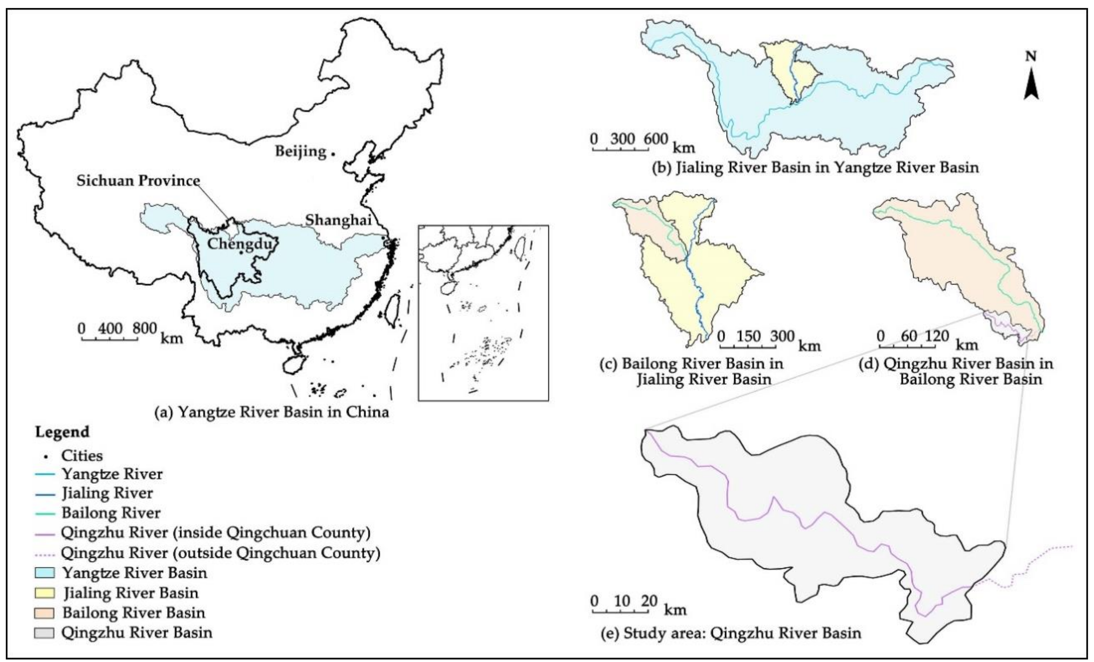
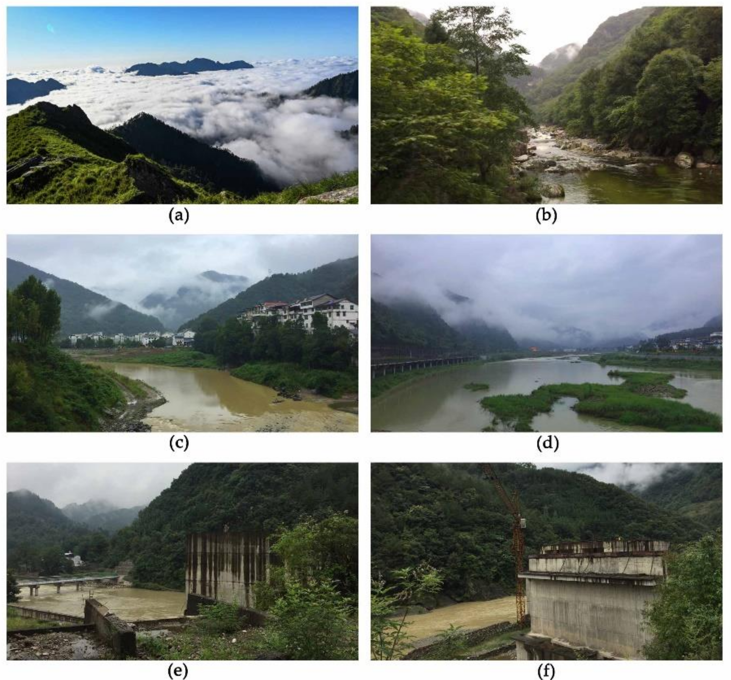
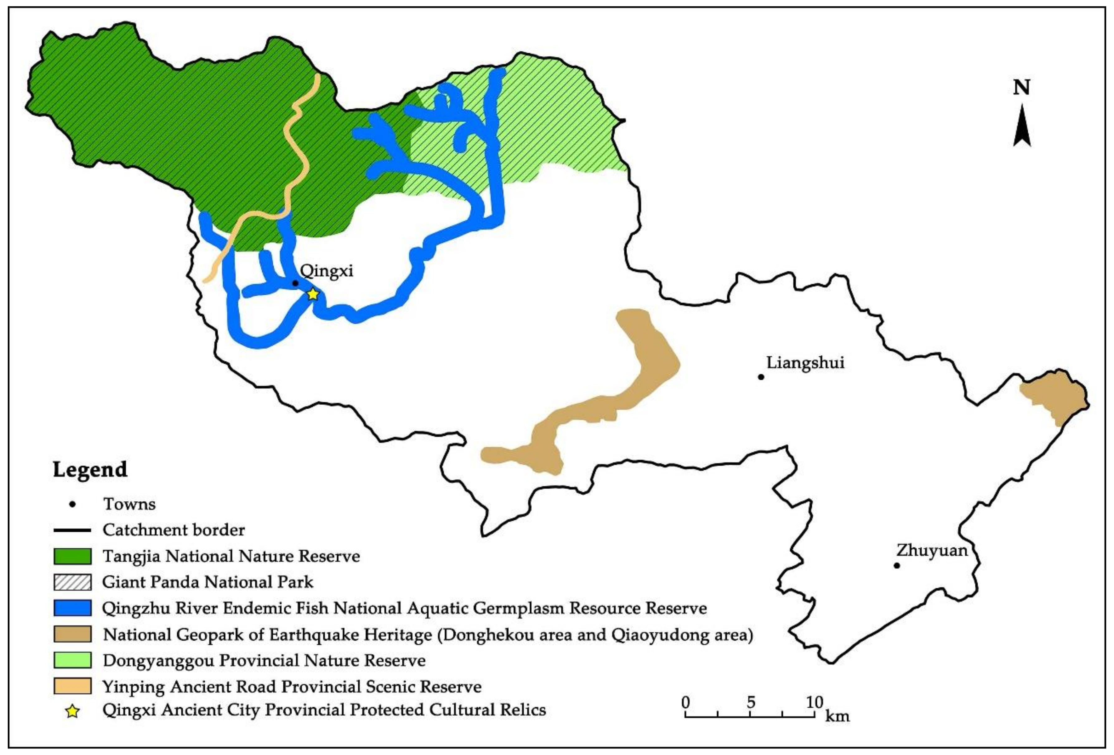
2.1. Case Study

The Qingzhu River Basin is situated in the mountains of southwest China, and this area is recognized as one of 34 global biodiversity hotspots. The rivers of the basin are highly developed, with obvious effects of human activities on the river ecosystem evident. The Qingzhu River is second-grade tributary of the Jialing River and a third-grade tributary of the Yangtze River. The Qingzhu River Basin is located in the northern region of Sichuan Province, China, with geographic coordinates of 32°05′–32°40′ N, 104°35′–105°40′ E. The headwaters of the Qingzhu River are located in the southern peaks of the Motianling Mountains at an altitude of 3837 m in Qingchuan County, near the northern margin of the Sichuan River Basin [29]. The river flows from northwest to southeast, has a length of 204 km and drains an area of 2873 km2 extending through three counties [30] (Figure 1).
The Qingzhu River is situated in the ecotone region between the Tibetan Plateau and the Sichuan River Basin. This area contains various animal and plant species, including 13 first-class nationally protected animal species such as the panda, more than 10 s-class nationally protected animals such as the giant salamander (Andrias davidianus) and 4 first-class nationally protected plant species such as ginkgo (Ginkgo biloba Linn) [29]. Five national and three provincial PAs have been established in the catchment due to its remarkably high biodiversity. The most well-known PA among these is the Tangjiahe National Nature Reserve, which partially falls within the Giant Panda National Park. The study area falls within an earthquake hotspot, and was severely impacted during the Wenchuan Earthquake in 2008. Moreover, increasing anthropogenic activities in recent years have negatively impacted the river ecosystem.
The Qingzhu River originates from alpine meadows at the headwaters region, following which it flows through an upstream forest region, a rural middle reach region and down to an urban downstream region. Landscape patterns change from upstream to downstream, from a wilderness landscape changing to a country landscape and finally to an urban landscape. The mean slope of the catchment according to the digital elevation model (DEM) calculation is ~21.43° and the altitude interval between the upper and lower reaches exceeds 3000 m, resulting in limited flat land and farmland within the catchment. However, over 100,000 people reside in villages on both sides of the valley (Figure A1a–d of Appendix A), as is typical of the majority of mountainous river catchments in southwest China. In addition, the present study indicated the upper reaches of the catchment to be the best protected. Some abandoned reservoirs remain along the middle and lower reaches of the river (Figure A1e,f), which may have an impact on conservation within the catchment.

2.2. Research Data

Table 1 shows more details on the research data used in the current study for the development of a model to identify PCARs.
The majority of data were obtained directly from relevant websites, following which these data were preprocessed to meet research requirements using ArcGIS software (v10.2, ESRI, Inc., Redlands City, CA, USA). A small proportion of the data, including species distribution, population and rural per-capita disposable income, were collected through on-site investigation. The research team of the current study visited the Qingzhu River 13 times from 2015 to 2019 for investigations of biodiversity, industrial structure and community development. Approximately 12 interviews with local government departments were held during these visits, such as with water resources management, fishery protection and forestry. Therefore, these previous field visits generated data that could be used in the present study. These data included species distribution data derived from interviews with local experts. Screening of data for 10 representative species allowed the catchment to be divided into 24 sub-catchments. The distribution range of the 10 identified species were then determined at the sub-catchment scale and distribution maps were constructed in ArcGIS (see Figure A2 and Table A1).

2.3. Ecosystem Integrity and Authenticity

The concept of ecosystem integrity can be traced back to the theory of land ethics proposed by Leopold [31]. The concept of ecosystem integrity can be generalized into two aspects: (1) complete constitutive elements and; (2) systematic features related to the diversity of structure and function [32,33]. Authenticity derives from the field of heritage protection, relates to the facticity and credibility for heritage and is emphasized to maintain an original state [34]. Authenticity is closely related to restoration ecology within the field of ecology. The concept of ecosystem authenticity includes natural authenticity and historical authenticity, with the former referring to the healthy status of an ecosystem after restoration, including sustained resilience, whereas the latter emphasizes that the state of a restored ecosystem is consistent with its historical unimpacted reference state [35,36].
The establishment of nature reserves is the foundation of global conservation strategies for effectively protecting biodiversity and maintaining the integrity and authenticity of ecosystems [5,37]. The concepts of ecosystem integrity and authenticity have been widely applied to nature reserves in recent years [38,39,40] and emphasize that the ecosystems of protected areas should possess excellent capacity for maintenance of biodiversity and quality [41]. Moreover, while ecosystem integrity and authenticity are the goals within the establishment of nature reserves, they are also importantly technical criteria for the spatial identification of protected areas. For example, ecosystem integrity was the main criterion used within the selection of land for the establishment of national parks in Canada [42]. Similarly, ecosystem integrity and authenticity are also considered as key indicators for the selection of sites for national parks in China [43,44].
In summary, as an important category of PAs, protected areas for rivers (hereafter referred to as PARs) should also consider the maintenance of the integrity and authenticity of a river ecosystem, and at the same time, are the ultimate goals for protection of a river.

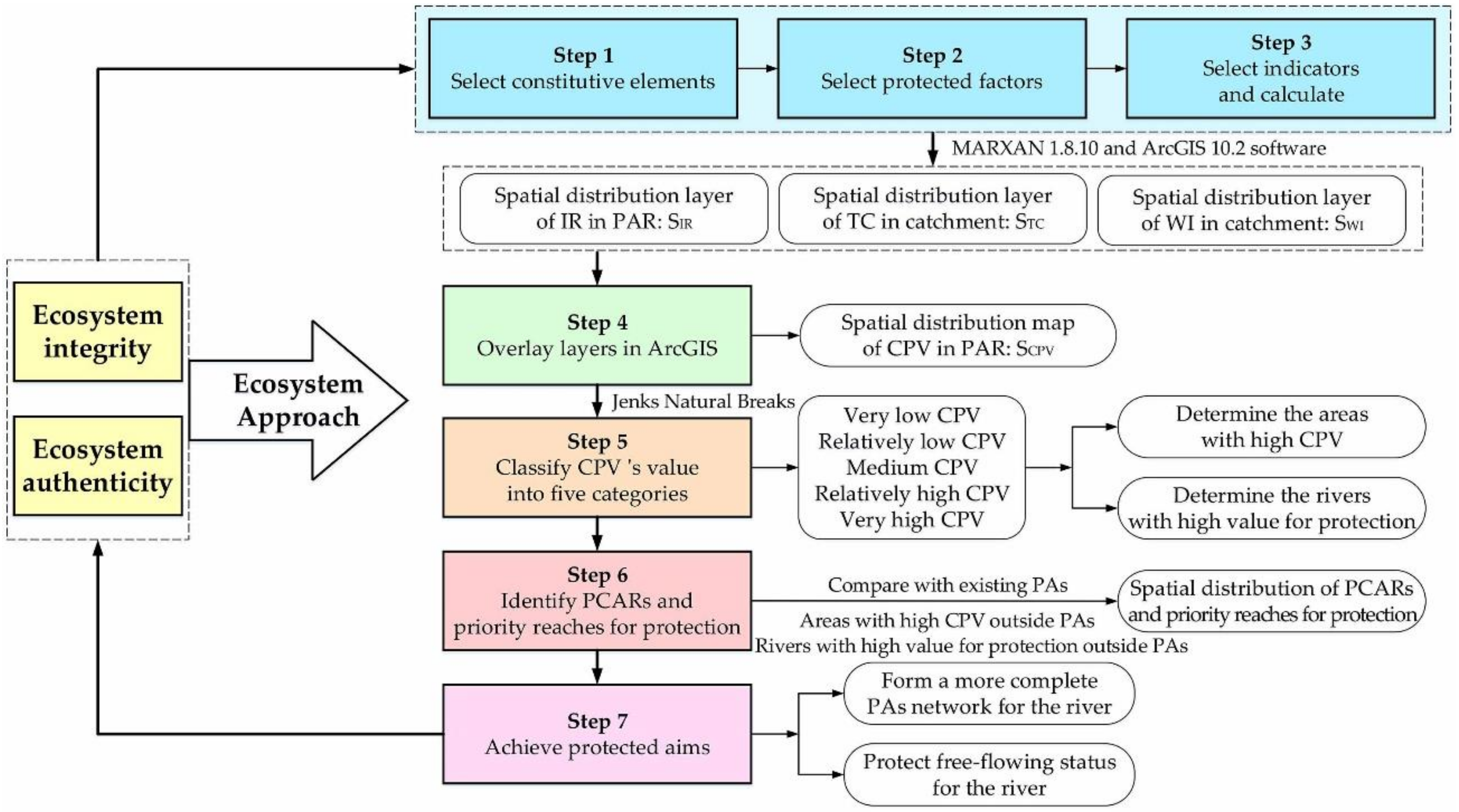
2.4. Analysis Framework

The analysis framework for identifying PCARs used in the present study is based on the ecosystem approach. This strategy integrates the management of land, water and living resources, thereby promoting conservation and sustainable use in an equitable manner [45] and allowing the consideration of ecosystem integrity and authenticity within the identification of PCAs with high biodiversity [46,47]. The ecosystem approach [46] or other similar methods related to ecosystem perspective, such as ecosystem-function-based approaches [48] or ecosystem-service-based approaches [49,50], etc. have been widely used for selecting PAs and identifying PCAs. The process for identifying PCARs is described in detail below.
Step 1. 
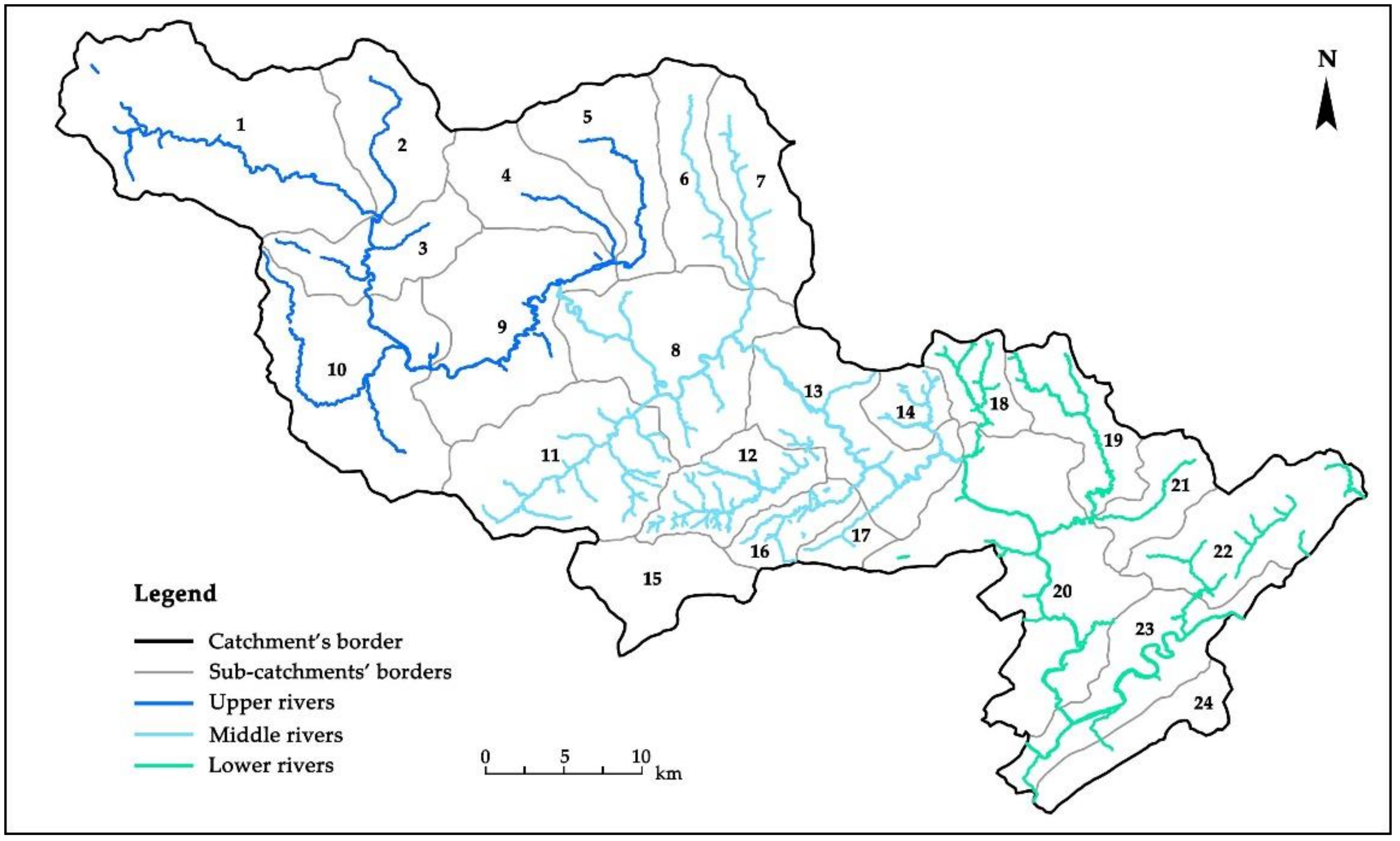
Determination of the spatial extent of PAR
Ecosystem integrity and authenticity can be achieved over a specific geographic space. Therefore, the determination of the specific spatial range of a PAR is regarded as the basis for identifying PCARs and priority reaches for protection.
The American National Wild and Scenic Rivers System (NWSRS) was the first specialized PA identification system for protected rivers globally and was signed into law by the US Congress in 1968 [51]. The NWSRS has been used to delineate the designated boundaries of PAs for rivers in the USA, with the default boundary of a designated river being: “that area measured within 0.25 miles (~400 m) from the normal high-water mark on each side of the river” [51,52]. The delineation of river PA boundaries aimed to protect various values of rivers, including scenic, recreational, and cultural values, as well as the free-flowing condition, water quality and immediate environments of rivers [53].
The current study utilized the NWSRS approach to identify the spatial scope of the PAR as the 400 m zone on both sides of the Qingzhu River using ArcGIS, which acted as the basic data for subsequent research.
Step 2. 
Selection of constitutive elements for integrity and authenticity of a river ecosystem
Similar to the integrity of an aquatic ecosystem, that of a river ecosystem can be broken down into three levels: (1) biodiversity integrity; (2) physical integrity and; (3) chemical integrity [54,55]. Within the present study, the authenticity of a river ecosystem was regarded as being related to the degree to which a river ecosystem is in a natural and original state, which was also related to the free-flowing status of a river.
In this case, the current study abstracted and extracted the constitutive elements of the river ecosystem. Streams, forest and human activity were selected as three constitutive elements of ecosystem integrity and authenticity for a river, which is the basis for identification of PCARs. Representative species of a river ecosystem, the condition of the forest covering of the catchment and the influence of human activity were correspondingly selected as factors embodying river ecosystem integrity and authenticity.
A river ecosystem includes various elements, including the hydrological cycle, fluctuating channel morphology, dissolved substances and sediments [56]. At a larger spatial scale, forests falling within a lakeshore region and catchment [57,58] as well as disturbance by human activities [59] can notably affect river ecosystem health and catchment biodiversity. Therefore, the three constitutive elements provide a good representation of river ecosystem integrity and authenticity: (a) Water quality of a river can affect the ecological environment of a catchment as well as social development in the watershed. Species that live in or around a river play a key role in material cycling and energy flow of a river ecosystem; therefore, the abundance and diversity of these species can indirectly reflect the long-term water quality and artesian condition of a river. (b) Forest land cover is an important component of the terrestrial ecosystem within a watershed and has significant impacts on a river ecosystem [60]. Forest can affect the hydrological cycle, and thus river runoff. In addition, forest cover can affect water quality and river morphology, ultimately influencing river ecosystem structure and function [56,61]. (c) Human activities such as forest logging, pollutant discharge and engineering construction can influence the balance between evapotranspiration and runoff, thereby changing river runoff [56] and affecting the river ecosystem. Furthermore, increasing unsustainable human activities result in the transition of the biological status of a river ecosystem from a natural state to degenerated state [62]. In conclusion, rivers located in areas with good water quality, high forest cover and low human impacts usually possess good ecosystem integrity and authenticity.
Step 3. 
Indicator selection and calculation
The selection of reasonable indicators based on constitutive elements and protected factors is crucial for constructing a model for PCAR identification. The present study selected irreplaceability (IR), tree cover (TC) and the wilderness index (WI) to characterize indicator species in the river, the condition of forest covering and the influence of human activities within a catchment, respectively. After data processing and calculation, three maps, namely the irreplaceability layer SIR, tree cover layer STC and wilderness index layer SWI were constructed using MARXAN (v1.8.0, Matthew E. Watts, The University of Queensland, Brisbane City, QLD, Australia) and ArcGIS, and were considered the basic layers for developing the model.
(1)
Irreplaceability
Irreplaceability (IR) is the core concept of systematic conservation planning (SCP) and is based on spatial units and considers the frequency at which a unit is selected by the planning model as a quantitative basis. IR indicates the degree to which a unit cannot be replaced by other units. This approach provides a comprehensive representation of biodiversity and conservation cost, and can reflect the sequence of conservation priorities for all planning units (PUs).
The current study applied SCP for the calculation of IR, following which IR was mapped using MARXAN software. The MARXAN interface incorporates the TerrSet software (v18.3.1, J. Ronald Eastman, Clark University in Worcester City, MA, USA), and therefore only support raster data. Within this process, the study area was first divided into planning units with dimensions of 30 m × 30 m, for a total of 2,090,290 PUs. A distribution layer for each species was constructed (see details in Table A1). A conservation cost layer was then constructed. Township population and rural per-capita disposable income were used as an indirect measure of cost based on related studies and obtainable data. The cost layer was constructed by superimposition after normalization of values. The MARXAN was then used to construct an IR spatial distribution. The protection percentage was set to 30% with reference to recent studies [6,63]. Debugging and sensitivity analysis were used to determine a BLM and SPF of 0.008 and 9.0, respectively. CostThreshold was not considered because the study did not examine an actual project. The number of iterations used was 100. Lastly, the result was extracted using ArcGIS, which was used to construct the map SIR of PAR.
(2)
Tree cover
The current study used a global tree cover dataset (treecover2010) with a pixel resolution of 30 m × 30 m and which estimates the 2010 percent maximum (peak of the growing season) tree canopy cover derived from cloud-free annual growing season composite Landsat 7 ETM+ data. These data represent the estimated maximum tree canopy cover per pixel as a percentage (1–100%) for the year 2010 as an integer value (1–100) [64]. The tree cover data (TC) for the Qingzhu River Catchment complied by projection conversion and extracted using ArcGIS, and the layer was labeled as STC.
(3)
Wilderness index
Areas in which there are no human influences tend to be selected as potential protected areas. These are usually characterized by a high degree of ecosystem integrity and authenticity. While many approaches exist for the quantification of human influence, there remains no approach for the concurrent calculation of non-human influences. The present study defined the concept of the wilderness index (WI) to characterize non-human influence, which takes on a value of −1 × the Human Footprint (HFP).
The HFP is a normalized indicator of the percentage of human influence relative to the highest recorded impact for each biome, and is generated using the Human Influence Index (HII) superimposed through the buffer zone and quantified using influence scores. The influence scores are based on four types of data, population density, land transformation, accessibility and electrical power infrastructure [65]. The investigated area is then sub-divided into 15 biomes according to the division method for the terrestrial biome by the World Wildlife Fund (WWF). The maximum and minimum HII in each biome is then calculated. Lastly, the HII is normalized to obtain the HFP [65,66].
In the present study, the HII was calculated based on the six raster layers: (1) population density; (2) land use; (3) road distribution; (4) railway distribution; (5) nighttime lights and; (6) slope distribution. More specifically, each layer represents a type of human activity and the associated influence indices were scored according to the standards proposed by SEDAC (NASA’s Socioeconomic Data and Applications Center) [66] and the experience of experts (see Table 2). The influence index values of these raster layers were then obtained by conducting operations of multiple buffer zones, resampling and reclassification in ArcGIS. Based on this, the HII spatial distribution map (layer SHII) was generated by overlaying the six layers, which reflected the composite human influences in a catchment. Lastly, the WI was calculated, with the spatial distribution map of HFP (layer SHFP) generated based on SHII and normalized formulae [67]. The distribution map (layer SWI) of the catchment was then constructed by multiplying SHFP by −1. Due to the numerical interval of HFP being is [0, 100] [65,67], it can be inferred that the range of WI will vary from −100 to 0.
Step 4. 
Weight determination and layer overlay
The concept of irreplaceability has traditionally been used to identify PCAs. An area of high irreplaceability will usually manifest as high biodiversity and conservation priorities. The current study combined ecosystem integrity and authenticity with abundance of representative species. In this way, species, forest and human activities were considered together within the identification of PCARs.
Similar to overlay approaches used in previous studies related to nature reserves [10,14,68], the present study overlaid SIR, STC and SWI using ArcGIS to generate an overlapped map S, which was labeled as the “map of comprehensive protected value” (hereafter CPV). The CPV was developed using the IR, TC and WI to indicate the protected value for each planning unit. Furthermore, the CPV is able to reflect ecosystem integrity and authenticity in a catchment. In actual fact, there are distinctive differences among different constitutive elements during the planning and construction of a PCAR. Therefore, the current study determined a different weight for each of the three elements using scoring by experts, and these weights were applied to SIR, STC and SWI when overlaying. The approach taken was:
S CPV   =   α 1 · S IR   +   α 2 · S TC   +   α 3 · S WI
In Equation (1), SCPV is the spatial pattern map of CPV and α 1 , α 2 and α 3 are the weights of SIR, STC and SWI, respectively. The values of the weights were determined according to experts within the fields of geography, ecology, biology, ichthyology, conservancy and hydro-science, as well as though consultation with nine other local experts as α 1 = 0.5, α 2 = 0.3 and   α 3 = 0.2.
The ecosystem approach was applied to construct the model in which ecosystem integrity and authenticity was considered. The result of the model characterized the CPV of each planning unit in the Qingzhu River. The value of the CPV was positively correlated with the integrity and authenticity of the ecosystem, and therefore with the priority for conservation. PCARs and priority reaches were identified through analyzing SCPV and comparing it with the present distribution of PAs. These areas were characterized by rich biodiversity, excellent forest growth and low or even no human influence. Figure 2 shows a schematic of the constructed model.

3. Results

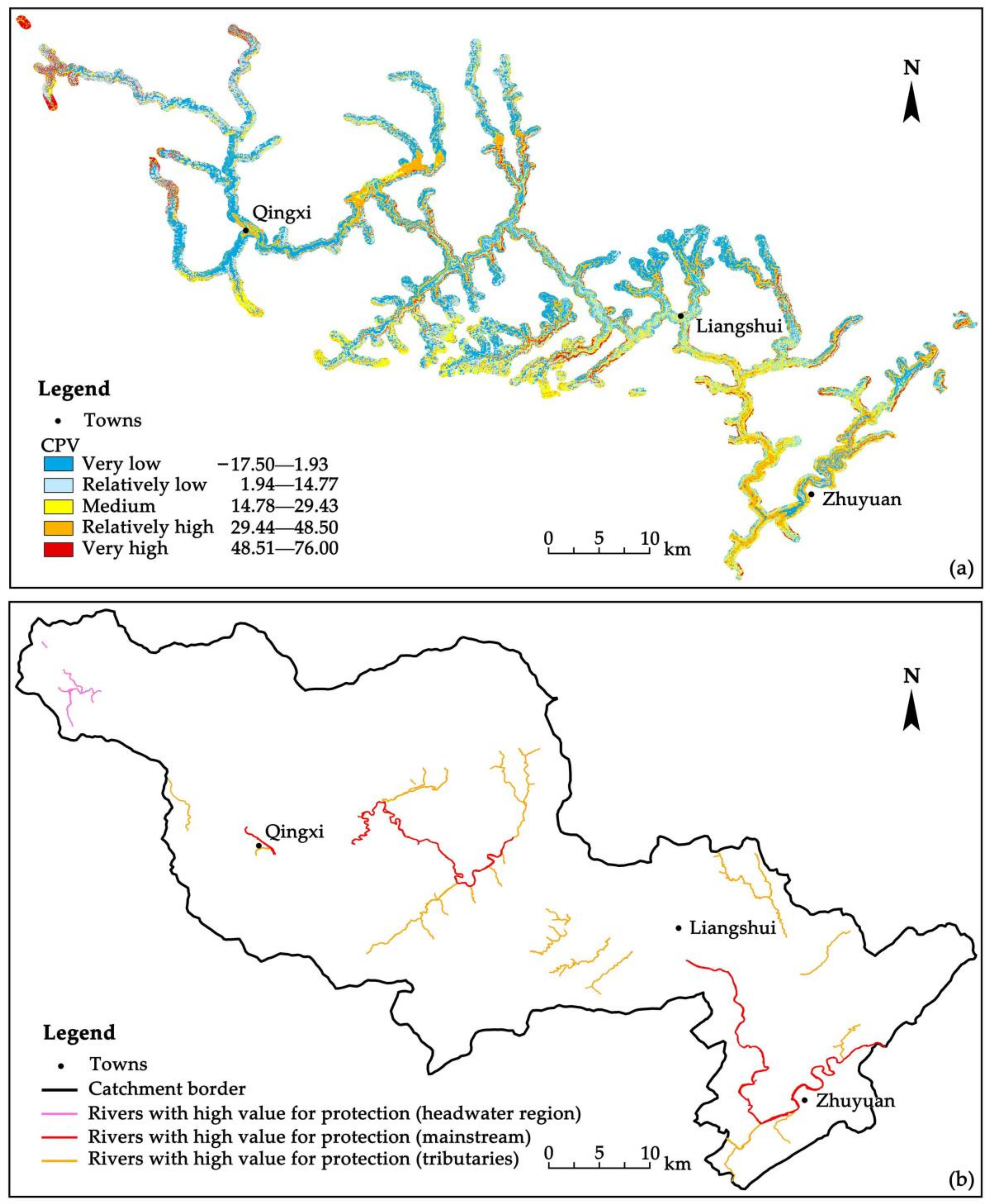
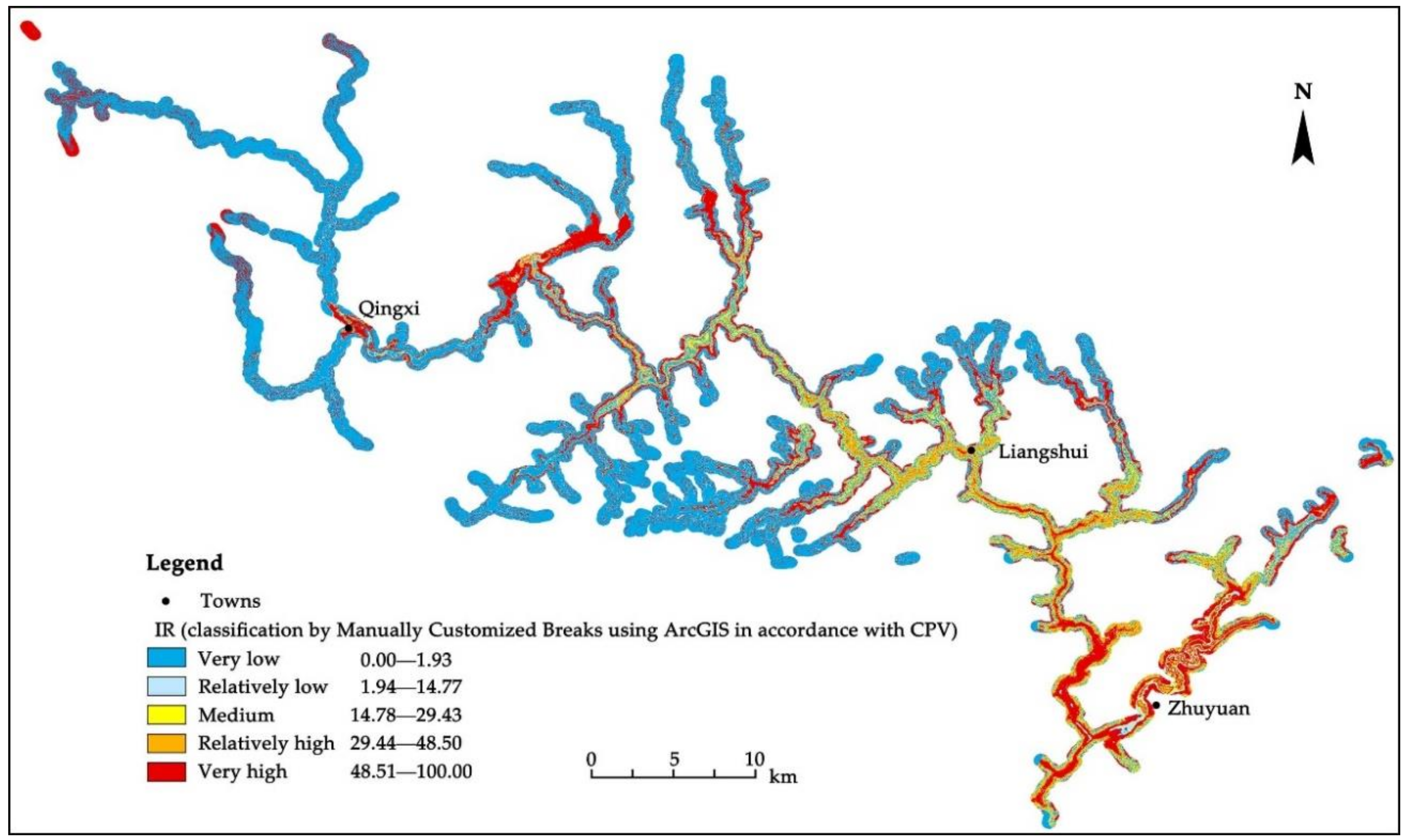
3.1. Spatial Patterns of CPV

The layers of spatial distribution were generated through data processing, calculation and overlay: (1) SIR (Figure A3a); (2) STC (Figure A3b) and; (3) SWI (Figure A3c). Resampling operations were conducted in ArcGIS to obtain a rational overlay of these layers and to obtain a uniform raster resolution in the three layers of 30 m × 30 m. The spatial distribution map SCPV in PAR was lastly generated based on Equation (1) (Figure 3a). Each raster (planning unit) of the result corresponded to a CPV value.
As shown in Figure A3a, areas with high IR were mainly concentrated in the PARs of the middle and lower reaches, with a small amount distributed in the PARs of upper reaches. The majority of these areas were distributed in PARs of mainstem reaches. In general, sub-catchments characterized by a distribution of aggregated high IR contained several indicator species, thereby providing an improved characterization of the distributions of indicator species selected within the current study. As shown in Figure A3b, high values of TC were obtained for areas of the Tangjiahe National Nature Reserve, the Dongyanggou Provincial Nature Reserve and the southern region of the catchment. These regions contained relatively few townships and thick forests. As shown in Figure A3c, the distribution of areas with high WI and the areas with high TC generally converged. The locations with high WI were absent of townships. By contrast, the region containing the town of Zhuyuan had the lowest WI and highest population in the catchment. Therefore, WI was able to reflect the actual status of human activities and indicated the feasibility of the approach for calculating WI.
Jenks Natural Breaks in ArcGIS was used to group the CPV of PARs into five categories (see Table 3). Among these categories, areas with very low CPV and relatively low CPV could be added together to indicate areas with low CPV, whereas areas with relatively high CPV and very high CPV could be added to indicated areas with high CPV. Areas with low and medium CPV accounted for the majority of PARs, with a proportion of ~59.76% and 19.71%, respectively. Few areas had high CPV values, accounting for ~20.53% of the entire PAR area. The majority of areas with high CPV were located in the mainstem of the river, with fewer located in tributaries of the middle and lower reaches. A small number of areas with high CPV were located in the PARs in the upper reaches, and mainly fell within existing PAs. Since CPV was generated using SIR, STC and SWI, areas with high conservation value comprehensively considered not only relatively complete protection for indicator species and low conservation cost, but also provided improved estimates of the integrity and authenticity of the ecosystem.
The present study identified reaches with high value for protection according to CPV (Figure 3b). Rivers distributing in these regions with good connectivity of aggregated high CPV areas were regarded as reaches with high value for protection. It should be noted that since these areas were easily distinguishable, they were identified by visual interpretation in the current study. Connectivity is a core concept within SCP as it is an embodiment of SCP within ecological processes. PAs with high connectivity would have a better ability to form a complete protected network of ecological space [69,70]. Since these areas could potentially be selected for PAs in the future, these reaches have high value for protection. Figure 3 reflects this high connectivity in the relatively complete regions formed by PUs with high CPV rather than those scattered PUs mainly distributed along the two sides or the centerline position of the PAR. This was particularly obvious in the middle and lower reaches of the river. The majority of reaches could be categorized as mainstem reaches. Measurement and estimation in ArcGIS showed that the total length of the mainstem was ~85.29 km, accounting for 55.39% of the mainstem within Qingchuan County.

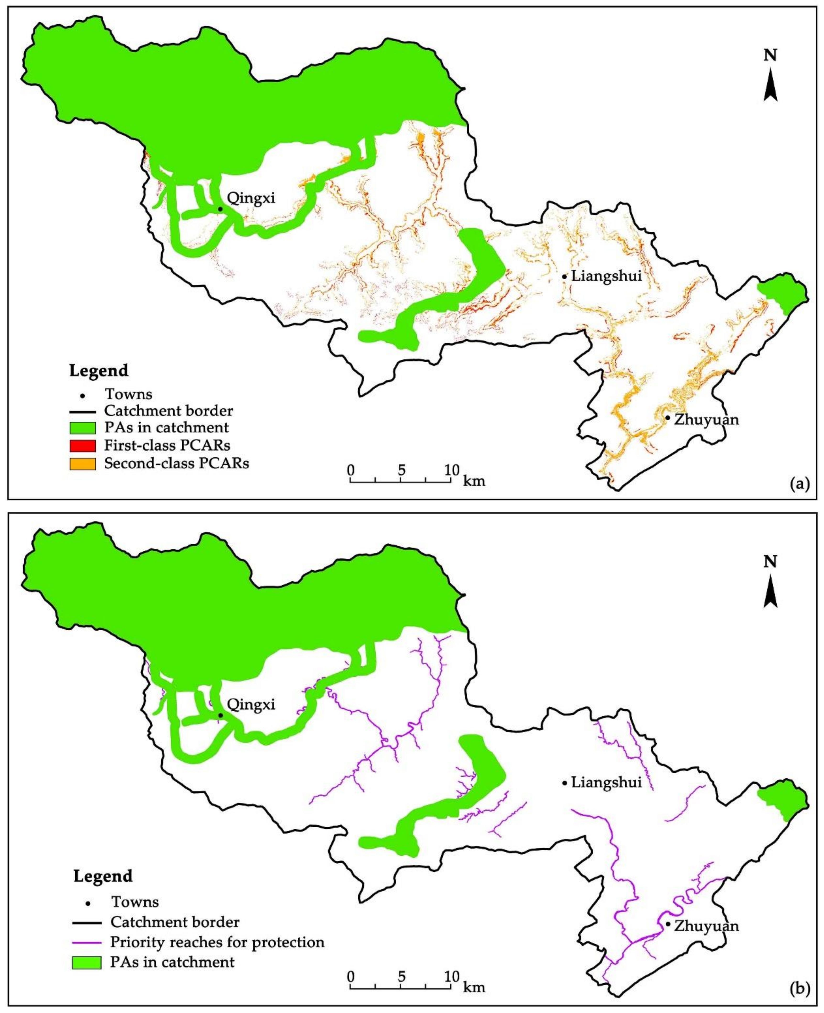
3.2. The Spatial Pattern of PCAR

The PAs in the catchment (Figure A4) were superimposed with the respective CPV map SCPV (Figure 3a) and the map of showing the distribution of reaches with high value for protection (Figure 3b) to identify PCARs (Figure 4a) and priority reaches for protection (Figure 4b). PCARs represent areas of high value for protection and areas which currently fall outside of existing PAs. Priority reaches for protection represent rivers with a high value for protection and at the same time fall outside of existing PAs (calculation results see Table 4).
The PCAR results were divided into two categories: (1) first-class PCARs and; (2) second-class PCARs. The former represent areas with very high CPV currently falling outside of PAs and possessing the highest priority for protection. The latter represent areas with relatively high CPV currently falling outside of PAs and with second-highest priority for protection. PCARs were mainly distributed in the middle and lower reaches of PAR areas due to the relatively improved PA network in the upper reaches. Relatively few PCARs were identified in the upper reaches. In fact, first- and second-class PCARs were mixed together. The number of second-class PCARs far exceeded that of first-class PCARs, with the total area of the former exceeding that of the latter by a factor of 3.31. First-class PCARs were mainly concentrated in the mountainous areas on both sides of middle reaches. In contrast, very few PCARs were identified in the upper and lower reaches. In addition, the majority of second-class PCARs were concentrated in the lower reaches.
Priority reaches for protection were mainly distributed in the middle rivers and lower reaches, with relatively few found in the upper reaches. Among these priority reaches, some were located near current PAs, namely in the upper reaches and middle-upper reaches, whereas the remainder were situated far away from existing PAs. Further analysis indicated that the majority of priority reaches for protection were distributed in the mainstem. This result indicated that priority reaches for protection were mainly locating in the middle and lower reaches.

4. Discussion

4.1. Theoretical Validation of CPV

Past studies on the identification of priority river areas for protection have mainly applied SCP through the use of spatial planning software such as MARXAN and ZONATION (v4.0, CBIG, University of Helsinki, Helsinki, Finland) [20,71] and through combining with species distribution models such as MAXENT (v2.4.1, Steven J. Phillips of Columbia University, Manhattan, New York City, NY, USA) [71] and MARS (Multivariate Adaptive Regression Splines) [24]. The current study combined TC and WI with SCP, thereby identifying PCAR areas within the Qingzhu River catchment based on CPV.
It should be noted that forest was distributed in the majority of regions in the catchment, resulting in a mean TC of 37.09. For this reason, consideration of forest and overlay using the layer STC was meaningful. In actual fact, although forest is an important component of a river ecosystem, the presence or absence of forest will not necessarily be an indicator of ecosystem condition. For instance, rivers running though desert or grassland biomes can also possess an excellent ecological condition. Therefore, although TC can be regarded as a key factor for determining river areas requiring protection, the importance of TC is case specific.
CPV was calculated using the three indicators IR, TC and WI, and PCARs were identified based on the SCPV distribution of high-value areas. Therefore, the theoretical verification of CPV requires comparative study of high-value areas between the two layers SIR and SCPV. The result of layer SIR was manually classified into five categories in ArcGIS to ensure a feasible comparison, with the result labeled SIR’, as shown in Figure A5, which corresponded with the classification of SCPV.
(1)
Comparison of the distribution of areas with high value for protection identified by SIR’ and SCPV
The purpose of a comparison of areas with high value for protection as identified by SIR’ and SCPV is to determine whether there is any difference between the two approaches in identifying areas of high value for protection. A result of no difference would indicate that there would be no value in overlaying the two spatial distributions and that the overlay step is not necessary.
The identification of a difference cannot be judged by visual interpretation alone. Therefore, relevant statistical data, namely raster data of areas with high value for protection, were analyzed using the statistical software SPSS 22.0 to determine the normality of the distribution of areas of high value for protection. The results of a single-sample Kolmogorov-Smirnov test (p < 0.01), P-P plot and Q-Q plot it indicated that SIR’ and SCPV were not normally distributed. Therefore, the non-parametric tests, Mann-Whitney U test, Moses Extreme Reactions test and χ2 test, were conducted (p < 0.01). The results showed that significant differences between the mean, numerical range and constituent ratio of areas with high value for protection existed between SIR’ and SCPV. It could therefore be inferred that the overlay had statistical significance.
(2)
The rationality of CPV
Previous studies have pointed out that the protection of 5–20% of the habitat area of representative species can achieve protection for over 50% of species based on examination of several PA planning cases [70]. Other scholars have confirmed that conservation targets such as 10% or 12% are insufficient [72]. In the present study, it was assumed that species were distributed across the entire range of a protected river. Therefore, the range could be regarded as the habitat of the studies species. The total coverage of areas identified as having high value for protection using SCPV in the current study accounted for ~20.53% of the total area, which was below the proportion of areas with high concentration value identified using SIR’ of 33.01%. Therefore, protection of these high-value areas will allow the conservation of over 50% of species in the range, which would be a relatively ideal outcome. In summary, the proportion of areas with high conservation value as determined through SCPV was appropriate for achieving an improved balance between species protection and land resource utilization. Furthermore, this proportion was conducive to achieving optimal protection while reducing the cost of conservation.
Compactness is a core concept in SCP, and the smaller the boundaries of PAs, the more compact and complete the distribution aggregation. In contrast, the larger the boundary, the more fragmented the aggregation. Compact PAs can be more easily and effectively managed for the protection of species, whereas fragmented PAs have a low management efficiency and are more difficult to manage for exotic invasive species [70]. The present study determined that these areas with high conservation value are likely to be incorporated into PAs in the future. Therefore, the current study compared the boundary lengths of areas with high conservation value identified between SIR’ and SCPV. Statistical analyses indicated that total boundary lengths under SIR’ and SCPV were 6261.46 km and 5221.08 km, respectively, with that of the latter reduced by 16.62% compared to the former. This result indicated that under the SCPV, there was greater aggregation of areas with high conservation value, which was conducive to the establishment of PAs and facilitated improved future conservation.

4.2. The Validation of CPV at a Practical Level

The validation of CPV at the practical level requires a comparison of the calculated result with the actual situation within a case study region. Some regions with aggregated areas of high conservation value as determined by SCPV were selected in the current study. More specifically, every raster (planning unit) with a high CPV value was transformed into point elements in ArcGIS for point density analysis, with the analyzed radius defined as 400 m. The map of distributed density was then generated. As shown in Figure 5, four regions with an aggregated distribution of areas with high conservation value were selected.
As shown in Figure 5, these four regions had different geographical locations, with region 1 being situated in the upper reaches, region 2 and region 3 both situated in the middle reaches and region 4 situated in the lower reaches. Therefore, these regions are representative of the entire river. These regions are characterized by both high biodiversity and rich species, with seven indicator species distributed in region 1 and six indicator species distributing in each of the remaining three regions. Indicator species in the four regions accounted for 70% of all indicator species examined in the present study, and therefore can better characterize the integrity of biodiversity of a river ecosystem. Furthermore, this result indicated that the aggregated distribution of areas with high conservation value corresponded with the actual ecological status of these region and that these regions include concentrated areas with high biodiversity value.
Related calculations showed that the distributed areas with relatively high conservation value exceeded those of very high conservation value, with the ratios of the areas among the four regions being 5.55, 2.51, 1.51 and 12.14, respectively. This result emphasizes the very small areas of very high conservation value, particularly in regions 1 and 4. Moreover, areas with very high conservation value were mostly concentrated in mountainous areas 100 m away from the riverbank. Correspondence with local experts and investigations within the current study indicated that the majority of these areas with high conservation value had steep topography and lush forest, and experienced minimal impact from human activities. Therefore, these areas have excellent ecosystem integrity and authenticity, and therefore extremely high conservation value. In addition, areas with relatively high conservation value were mostly concentrated near rivers and villages with higher human populations and increased human activity. These locations showed relatively sparse forest grown and relatively poorer growth conditions. Setting up PAs within these areas will pose a greater challenge and the conservation cost will be higher due to need to consider multiple factors. Since these areas have high species richness, these areas also have relatively high value for conservation, but relatively lower value compared to areas with very high conservation value.
In summary, the aggregated distribution of areas with high conservation value in the four regions was consistent with the actual situation. Furthermore, it can be inferred that CPV is in general consistent with reality.

5. Conclusions and Outlook

Although previous studies have partially considered additional factors within the identification of PCARs, such as human activities and landscape, few studies have attempted to quantitatively measure the influences of these factors. The present study combined IR, TC and WI for the development of a quantitative indicator of CPV to identify PCAR areas and priority reaches for protection. Lastly, the current study demonstrated the feasibility of CPV from both theorical and practical perspectives. The spatial patterns of PCARs and priority reaches for protection indicated that certain measures, such as the expansion of existing PAs, the establishment of new PAs and the strengthening of water source quality management can be proposed to achieve better protection for the Qingzhu river.
The present study developed a novel model for the identification of PCARs. The ecosystem approach was applied based on ecosystem integrity and authenticity to construct a quantified and spatially visible model for the identification of PCARs and priority reaches for protection. This approach is conducive to achieving efficient and smart management of the river. This analytical framework could assist managers in not only calculating the CPV for a river, but also in achieving rational spatial planning of PAs. The results of the present study can also encourage future studies to consider additional factors within the identification of areas for conservation. The framework developed in the present study can be adapted to suit specific rivers.
The model examined in the present study was heavily theoretical, and some limitations to the study persist due to the difficulties associated with data collection and other factors. For example, the number of indicator species selected and range of study area examined were small. Therefore, future studies should attempt to demonstrate the feasibility of the framework at a larger regional scale. The rationality of the 400 m range according to the natural conditions and river characteristics in China can be verified. The number and kinds of indicator species can be expanded to better characterize the comprehensiveness of biodiversity in the study area. Factors such as society, culture and landscape can be integrated into the model.
Furthermore, further research is required to determine whether forest is suitable for identifying PCAR areas of other types of rivers. The study area examined in the present study fell within mountainous topography, and consequently the majority of rivers were of the mountain-river or forest-river type. However, the rationality of applying forest for the identification of PCARs needs to be verified for rivers in other areas in which forest is sparsely distributed, such as grassland, tundra and barren land.

Author Contributions

Conceptualization: P.L., Y.Z. and M.Z. (Min Zhao); methodology: all authors; software, Y.Z., W.L. and M.Z. (Meng Zhu); validation: P.L. and Y.Z.; formal analysis: Y.Z. and M.Z. (Meng Zhu); investigation: all authors; data curation, Y.Z.; writing—original draft preparation, P.L., Y.Z. and M.Z. (Meng Zhu); writing—review and editing, all authors; project administration, P.L.; funding acquisition, P.L. All authors have read and agreed to the published version of the manuscript.

Funding

This research was funded by the National Natural Science Foundation of China (grant number 41761111): Study on space defining of protected area for river in ecologically vulnerable area of southwestern China—Sichuan Province as a case.

Informed Consent Statement

Not applicable.

Data Availability Statement

Data was obtained from third party and are available at URL that were specified in paper. The URL includes the following: http://www.resdc.cn; http://www.gscloud.cn; www.noaa.gov; https://glad.umd.edu/dataset/global-2010-tree-cover-30-m.

Acknowledgments

We are grateful for the assistance provided by Fengqi Li (director of the Qingchuan County Agricultural Promotion Center) within the collection of species distribution data and several other aspects of our investigation in Sichuan Province. We thank Yangyang Du (assistant engineer of the Qingchuan County Water Conservancy Bureau), other experts and staff members from Qingchuan County for their help in the collection of materials.

Conflicts of Interest

The authors declare no conflict of interest.

Appendix A

Figure A1. Photographs representing several scenes of the Qingzhu River. (a) Headwater region (Tangjiahe National Nature Reserve); (b) Upper reach; (c) Middle reach; (d) Lower reach; (e) An abandoned dam along the river; (f) Another abandoned dam along the river. Notes: picture (a) was sourced from the website of the Tangjiahe National Nature Reserve Management Office, Sichuan Province: http://www.tjhnr.cn/web/square/detail/464/30307/483?aa=0.2539124920918432; the remaining photographs were captured by the research team.
Sustainability 13 00323 g0a1
Figure A2. Sub-catchments of the Qingzhu River Basin within Qingchuan County, southwest China and their numbering. Notes: Since no river was evident in sub-catchment 15, the present study did not consider related data in this catchment within calculations and spatial analysis.
Sustainability 13 00323 g0a2
Figure A3. The spatial patterns of irreplaceability (IR) in protected areas for a river (PARs): layer SIR (a), tree cover (TC): layer STC (b) and wilderness index (WI): layer SWI (c) within the Qingzhu River Basin within Qingchuan County, southwest China. Notes: three towns were labeled are representative, and are located within the upper, middle and lower reaches. Among them, Qingxi has the largest population in the catchment and contains the well-known Qingxi Ancient city tourist site; Liangshui is the most populous town in the middle reaches and is located at the juncture of the middle and lower reaches; Zhuyuan is the second-most populous town in the catchment and the industrial, economic, commercial and logistics center of the catchment (the same below).
Sustainability 13 00323 g0a3
Figure A4. Map showing the distribution of protected areas (PAs) in the Qingzhu River Basin within Qingchuan County, southwest China. Notes: the range of the catchment is in accordance with Qingzhu River National Water Conservancy Sight. Water conservancy sight is a unique concept in China, and is a mode of resource utilization and protection and plays an important role in the protection of the aquatic ecosystems of sites that do not currently fall within any PAs.
Sustainability 13 00323 g0a4
Figure A5. The spatial distribution of irreplaceability (IR) after classification: layer SIR’ for the Qingzhu River Basin within Qingchuan County, southwest China The aim of this map was to allow an obvious comparison with the map of comprehensive protected value (SCPV). Since IR generally takes on integer values, IR was classified manually in ArcGIS using the decimal type to allow a comparison with CPV.
Sustainability 13 00323 g0a5
Table A1. Selected species and their distributions. The current study selected eight fishes and two amphibian species (Andrias davidianus, Tylototriton wenxianensis) distributed in water or on land. Since the current study considered ecosystem integrity and authenticity, the distributions of species both in water and on land were considered at the sub-catchment scale. Specifically, it was assumed that species were distributed within protected areas for a river (PARs) in the sub-catchments in which a certain species was distributed. The species distribution map was constructed in ArcGIS based on this assumption.
Species NameEndemismProtection ClassNoteDistribution Sub-Catchments
Schizothorax prenantiR 1, 2, 3, 10
Schizothorax (Racoma) davidi Provincial 10
Schizothorax siensisR 1, 2, 3, 10
Schistura fasciolataR 3, 8, 9, 10, 13, 20
Paracobitis potaniniR 1–10, 12, 13, 14, 19, 20, 21, 23
Sinogastromyzon szechuanensisRProvincial 1–10, 12, 13, 14, 19, 20, 21, 23
Euchiloglanis kishinouyeiR 1–11, 13, 14, 16, 17, 20, 21, 23
EdavidiRProvincial 1–11, 13, 14, 16, 17, 20, 21, 23
Andrias davidianus (Giant salamander)RNational IIIUCN: EN1–14, 16–24
Tylototriton wenxianensis (Wenxian wart newt)RNational IIIUCN: VN1–6

References

  1. Mukul, S.A.; Rashid, A.Z.M.M. Protected Areas: Policies, Management and Future Directions; Nova Science Publishers: New York, NY, USA, 2017. [Google Scholar]
  2. Venter, O.; Fuller, R.A.; Segan, D.B.; Carwardine, J.; Brooks, T.; Butchart, S.H.M.; Di Marco, M.; Iwamura, T.; Joseph, L.; O’Grady, D.; et al. Targeting Global Protected Area Expansion for Imperiled Biodiversity. PLoS Biol. 2014, 12, e1001891. [Google Scholar] [CrossRef] [Green Version]
  3. Mukul, S.A.; Sohel, M.S.I.; Herbohn, J.; Inostroza, L.; König, H. Integrating ecosystem services supply potential from future land-use scenarios in protected area management: A Bangladesh case study. Ecosyst. Serv. 2017, 26, 355–364. [Google Scholar] [CrossRef]
  4. Primack, R.B. Essentials of Conservation Biology, 5th ed.; Sinauer Associates, Inc.: Sunderland, UK, 2010. [Google Scholar]
  5. Dudley, N.; Shadie, P.; Stolton, S. Guidelines for Applying Protected Area Management Categories; IUCN: Gland, Switzerland, 2013. [Google Scholar]
  6. Fernandes, M.D.L.; Quintela, A.; Alves, F.L. Identifying conservation priority areas to inform maritime spatial planning: A new approach. Sci. Total Environ. 2018, 639, 1088–1098. [Google Scholar] [CrossRef] [PubMed]
  7. Bax, V.; Francesconi, W. Conservation gaps and priorities in the Tropical Andes biodiversity hotspot: Implications for the expansion of protected areas. J. Environ. Manag. 2019, 232, 387–396. [Google Scholar] [CrossRef] [PubMed]
  8. Walsh, A.; Sullivan, C.A.; Waldren, S.; Finn, J.A. Development of a scoring method to identify important areas of plant diversity in Ireland. J. Nat. Conserv. 2019, 47, 1–11. [Google Scholar] [CrossRef] [Green Version]
  9. Pikesley, S.K.; Godley, B.J.; Latham, H.; Richardson, P.B.; Robson, L.M.; Solandt, J.L.; Trundle, C.; Wood, C.; Witt, M.J. Pink sea fans (Eunicella verrucosa) as indicators of the spatial efficacy of Marine Protected Areas in southwest UK coastal waters. Mar. Policy 2016, 64, 38–45. [Google Scholar] [CrossRef]
  10. Zhang, Z.M.; Sherman, R.; Yang, Z.J.; Wu, R.D.; Wang, W.L.; Yin, M.; Yang, G.H.; Ou, X.K. Integrating a participatory process with a GIS-based multi-criteria decision analysis for protected area zoning in China. J. Nat. Conserv. 2013, 21, 225–240. [Google Scholar] [CrossRef]
  11. Habtemariam, B.T.; Fang, Q. Zoning for a multiple-use marine protected area using spatial multi-criteria analysis: The case of the Sheik Seid Marine National Park in Eritrea. Mar. Policy 2016, 63, 135–143. [Google Scholar] [CrossRef]
  12. Bottrill, M.C.; Joseph, L.N.; Carwardine, J.; Bode, M.; Cook, C.; Game, E.; Grantham, H.; Kark, S.; Linke, S.; McDonald-Madden, E.; et al. Finite conservation funds mean triage is unavoidable. Trends Ecol. Evol. 2009, 24, 183–184. [Google Scholar] [CrossRef]
  13. Hanson, J.O.; Rhodes, J.R.; Butchart, S.H.M.; Buchanan, G.M.; Rondinini, C.; Ficetola, G.F.; Fuller, R.A. Global conservation of species’ niches. Nature 2020, 580, 232–234. [Google Scholar] [CrossRef]
  14. Yang, R.; Cao, Y.; Hou, S.Y.; Peng, Q.Y.; Wang, X.S.; Wang, F.Y.; Tseng, T.; Yu, L.; Carver, S.; Convery, I.; et al. Cost-effective priorities for the expansion of global terrestrial protected areas: Setting post-2020 global and national targets. Sci. Adv. 2020, 6, 1–8. [Google Scholar] [CrossRef] [PubMed]
  15. Lv, Z.; Yang, J.; Wielstra, B.; Wei, J.; Xu, F.; Si, Y. Prioritizing green spaces for biodiversity conservation in Beijing based on habitat network connectivity. Sustainability 2019, 11, 2042. [Google Scholar] [CrossRef] [Green Version]
  16. Asaad, I.; Lundquist, C.J.; Erdmann, M.V.; Costello, M.J. Delineating priority areas for marine biodiversity conservation in the Coral Triangle. Biol. Conserv. 2018, 222, 198–211. [Google Scholar] [CrossRef] [Green Version]
  17. Moradi, S.; Ilanloo, S.S.; Kafash, A.; Yousefi, M. Identifying high-priority conservation areas for avian biodiversity using species distribution modeling. Ecol. Indic. 2019, 97, 159–164. [Google Scholar] [CrossRef]
  18. Pouget, M.; Baumel, A.; Diadema, K.; Medail, F. Conservation unit allows assessing vulnerability and setting conservation priorities for a Mediterranean endemic plant within the context of extreme urbanization. Biodivers. Conserv. 2017, 26, 293–307. [Google Scholar] [CrossRef] [Green Version]
  19. Carrizo, S.F.; Lengyel, S.; Kapusi, F.; Szabolcs, M.; Kasperidus, H.D.; Scholz, M.; Markovic, D.; Freyhof, J.; Cid, N.; Cardoso, A.C.; et al. Critical catchments for freshwater biodiversity conservation in Europe: Identification, prioritisation and gap analysis. J. Appl. Ecol. 2017, 54, 1209–1218. [Google Scholar] [CrossRef] [Green Version]
  20. Holland, R.A.; Darwall, W.R.T.; Smith, K.G. Conservation priorities for freshwater biodiversity: The Key Biodiversity Area approach refined and tested for continental Africa. Biol. Conserv. 2012, 148, 167–179. [Google Scholar] [CrossRef]
  21. Burnett, K.; Reeves, G.; Miller, D.; Clarke, S.; Christiansen, K.; Vance-Borland, K. Aquatic protected areas: What works best and how do we know? In Proceedings of the World Congress on Aquatic Protected Areas, Cairns, Australia, 14–17 August 2002; Beumer, J.P., Grant, A., Smith, D.C., Eds.; Australian Society for Fish Biology: North Beach, WA, Australia, 2003. [Google Scholar]
  22. Nel, J.L.; Roux, D.J.; Maree, G.; Kleynhans, C.J.; Moolman, J.; Reyers, B.; Rouget, M.; Cowling, R.M. Rivers in peril inside and outside protected areas: A systematic approach to conservation assessment of river ecosystems. Divers. Distrib. 2007, 13, 341–352. [Google Scholar] [CrossRef]
  23. Grill, G.; Lehner, B.; Thieme, M.; Geenen, B.; Tickner, D.; Antonelli, F.; Babu, S.; Borrelli, P.; Cheng, L.; Crochetiere, H.; et al. Mapping the world’s free-flowing rivers. Nature 2019, 569, 215–221. [Google Scholar] [CrossRef]
  24. Dolezsai, A.; Sály, P.; Takács, P.; Hermoso, V.; Erős, T. Restricted by borders: Trade-offs in transboundary conservation planning for large river systems. Biodivers. Conserv. 2015, 24, 1403–1421. [Google Scholar] [CrossRef] [Green Version]
  25. Hua, Y.; Cui, B.; He, W.; Cai, Y. Identifying potential restoration areas of freshwater wetlands in a river delta. Ecol. Indic. 2016, 71, 438–448. [Google Scholar] [CrossRef] [Green Version]
  26. Chen, L.; Fan, M.; Wang, Q. Spatial priority conservation areas for vegetation habitat across the Upper Reaches of Min River located in Sichuan Province, China. Glob. Ecol. Conserv. 2019, 17, 1–13. [Google Scholar] [CrossRef]
  27. Funk, A.; Martínez-López, J.; Borgwardt, F.; Trauner, D.; Bagstad, K.J.; Balbi, S.; Magrach, A.; Villa, F.; Hein, T. Identification of conservation and restoration priority areas in the Danube River based on the multi-functionality of river-floodplain systems. Sci. Total Environ. 2019, 654, 763–777. [Google Scholar] [CrossRef] [PubMed]
  28. Zhang, L.; Ouyang, Z.Y.; Xu, W.H. Theory, work frame and hot issues of systematic conservation planning. Acta Ecol. Sin. 2015, 35, 1284–1295. [Google Scholar]
  29. Hu, J.C.; Deng, H.K.; Zhang, J.; Li, M.F.; Li, Y.H.; Li, C.; Xu, X.; Ou, W.F.; Chen, L.M.; Qin, Z.S.; et al. A Comprehensive Scientific Investigation Report on Tangjiahe Nature Reserve in Sichuan Province, China; Sichuan Science and Technology Press: Chengdu, China, 2005. [Google Scholar]
  30. Codification Committee of Guangyuan City Local Chronicles. Guangyuan County Annals; Sichuan Cishu Publishing House: Chengdu, China, 1994. [Google Scholar]
  31. Leopold, A. Sand County Almanac and Sketches Here and There; Oxford University Press: New York, NY, USA, 1949. [Google Scholar]
  32. Karr, J.R.; Dudley, I.J. Ecological perspective on water quality goals. Environ. Manag. 1981, 5, 55–68. [Google Scholar] [CrossRef]
  33. Miller, P.; Ehnes, J.M. Can Canadian approaches to sustainable forest management maintain ecological integrity? In Ecological Integrity: Integrating Environment, Conservation, and Health; Pimentel, D., Westra, L., Noss, R.F., Eds.; Island Press: Washington, DC, USA, 2000; Chapter 9; pp. 157–176. [Google Scholar]
  34. UNESCO. Operational Guidelines for the Implementation of the World Heritage Convention; UNESCO World Heritage Centre: Paris, France, 2019. [Google Scholar]
  35. He, S.Y.; Su, Y. Authenticity, integrity, connectivity and coordination-conceptual analysis and practical significance for the establishment of the National Park system. Environ. Prot. 2019, 47, 28–34. [Google Scholar]
  36. Clewell, A.F. Restoring for natural authenticity. Ecol. Restor. 2000, 18, 216–217. [Google Scholar] [CrossRef] [Green Version]
  37. IUCN; WCMC. Guidelines for Protected Area Management Categories; IUCN: Gland, Switzerland, 1994. [Google Scholar]
  38. Parrish, J.D.; Braun, D.P.; Unnasch, R.S. Are we conserving what we say we are? Measuring ecological integrity within protected areas. BioScience 2003, 53, 851–860. [Google Scholar] [CrossRef] [Green Version]
  39. Laurich, B.; Drake, C.; Gorman, O.T.; Irvine, C.; MacLaurin, J.; Chartrand, C.; Hebert, C.E. Ecosystem change and population declines in gulls: Shifting baseline considerations for assessing ecological integrity of protected areas. J. Great Lakes Res. 2019, 45, 764–775. [Google Scholar] [CrossRef]
  40. Faber-Langendoen, D.; Lemly, J.; Nichols, W.; Rocchio, J.; Walz, K.; Smyth, R. Development and evaluation of NatureServe’s multi-metric ecological integrity assessment method for wetland ecosystems. Ecol. Indic. 2019, 104, 764–775. [Google Scholar] [CrossRef]
  41. Dudley, N. Authenticity in Nature: Making Choices about the Naturalness of Ecosystems; Routledge: London, UK; New York, NY, USA, 2012. [Google Scholar]
  42. Fraser, R.H.; Olthof, I.; Pouliot, D. Monitoring land cover change and ecological integrity in Canada’s national parks. Remote Sens. Environ. 2009, 113, 1397–1409. [Google Scholar] [CrossRef]
  43. Yu, H.; Zhong, L.S. Discussion on the selection criteria of national parks in China based on international experience. Acta Ecol. Sin. 2019, 39, 1309–1317. [Google Scholar]
  44. Wang, Y. Practice and innovation for overarching institution design of China’s national park. Biodivers. Sci. 2018, 25, 1037–1039. [Google Scholar] [CrossRef] [Green Version]
  45. Secretariat of the Convention on Biological Diversity (CBD). CBD GUIDELINES: The Ecosystem Approach; The Secretariat of the Convention on Biological Diversity: Montreal, QC, Canada, 2004.
  46. Gill, S. The Ecosystem Approach: Five Steps to Implementation (from IUCN Website). Available online: https://www.iucn.org/content/ecosystem-approach-five-steps-implementation-0 (accessed on 16 June 2020).
  47. Browman, H.I.; Stergiou, K.I. Marine Protected Areas as a central element of ecosystem-based management: Defining their location, size and number. Mar. Ecol. Prog. Ser. 2004, 274, 271–272. [Google Scholar]
  48. Peng, J.; Wang, A.; Luo, L.W.; Liu, Y.X.; Li, H.L.; Hu, Y.N.; Meersmans, J.; Wu, J.S. Spatial identification of conservation priority areas for urban ecological land: An approach based on water ecosystem services. Land Degrad. Dev. 2019, 30, 683–694. [Google Scholar] [CrossRef] [Green Version]
  49. Fan, M.; Shibata, H.; Wang, Q. Optimal conservation planning of multiple hydrological ecosystem services under land use and climate changes in Teshio river watershed, northernmost of Japan. Ecol. Indic. 2016, 62, 1–13. [Google Scholar] [CrossRef]
  50. Xu, W.H.; Xiao, Y.; Zhang, J.J.; Yang, W.; Zhang, L.; Hull, V.; Wang, Z.; Zheng, H.; Liu, J.G.; Polasky, S.; et al. Strengthening protected areas for biodiversity and ecosystem services in China. Proc. Natl. Acad. Sci. USA 2017, 114, 1601–1606. [Google Scholar] [CrossRef] [Green Version]
  51. ABOUT THE WSR ACT: Safeguarding the Character of Our Nation’s Unique Rivers. Available online: https://www.rivers.gov/wsr-act.php (accessed on 22 September 2020).
  52. Brougher, C. The Wild and Scenic Rivers Act (WSRA): Protections, Federal Water Rights, and Development Restrictions (CRS Report for Congress); Congressional Research Service: Washington, DC, USA, 2010; Report Number: R41081.
  53. Perry, D.M. Reframing the Wild and Scenic Rivers Act for Ecosystem Based Resilience and Adaptation. J. Wilderness Med. 2017, 23, 41–48. [Google Scholar]
  54. Song, M.M.; Tian, S.; Lu, A.R.; Yin, X.W.; Xu, Z.X. Establishment of evaluation system of an ecosystem integrity in Weihe River. J. Dalian Ocean Univ. 2020, 35, 288–295. [Google Scholar]
  55. Huang, B.R.; Ouyang, Z.Y.; Zheng, H.; Wang, X.K.; Miao, H. Connotation of ecological integrity and its assessment methods: A review. Chin. J. Appl. Ecol. 2006, 17, 2196–2202. [Google Scholar]
  56. Allan, J.D.; Castillo, M.M. Stream Ecology: Structure and Function of Running Waters; Springer Science & Business Media: Berlin, Germany, 2007. [Google Scholar]
  57. Mo, K.; Chen, Q.W.; Chen, C.; Zhang, J.Y.; Wang, L.; Bao, Z.X. Spatiotemporal variation of correlation between vegetation cover and precipitation in an arid mountain-oasis river basin in northwest China. J. Hydrol. 2019, 574, 138–147. [Google Scholar] [CrossRef]
  58. Barber, C.P.; Cochrane, M.A.; Souza, C.M.; Laurance, W.F. Roads, deforestation, and the mitigating effect of protected areas in the Amazon. Biol. Conserv. 2014, 177, 203–209. [Google Scholar] [CrossRef]
  59. Januchowski-Hartley, S.; Pearson, R.; Puschendorf, R.; Rayner, T. Fresh waters and fish diversity: Distribution, protection and disturbance in Tropical Australia. PLoS ONE 2011, 6, e25846. [Google Scholar] [CrossRef] [PubMed]
  60. Hewlett, J.D. Principles of Forest Hydrology; University of Georgia Press: Athens, GA, USA, 1982. [Google Scholar]
  61. Wei, X.H.; Sun, G. Watershed Ecosystem Processes and Management, 1st ed.; Higher Education Press: Beijing, China, 2009. [Google Scholar]
  62. Davies, S.P.; Jackson, S.K. The biological condition gradient: A descriptive model for interpreting change in aquatic ecosystems. Ecol. Appl. 2006, 16, 1251–1266. [Google Scholar] [CrossRef]
  63. Stewart, R.R.; Possingham, H.P. Efficiency, costs and trade-offs in marine reserve system design. Environ. Modeling Assess. 2005, 10, 203–213. [Google Scholar] [CrossRef]
  64. Global Land Analysis & Discovery (GLAD), Global 2010 Tree Cover (30 m). Available online: https://glad.umd.edu/dataset/global-2010-tree-cover-30-m (accessed on 7 October 2019).
  65. Sanderson, E.W.; Jaiteh, M.; Levy, M.A.; Redford, K.H.; Wannebo, A.V.; Woolmer, G. The human footprint and the last of the wild: The human footprint is a global map of human influence on the land surface, which suggests that human beings are stewards of nature, whether we like it or not. BioScience 2002, 52, 891–904. [Google Scholar] [CrossRef]
  66. NASA Socioeconomic Data and Applications Center (SEDAC). A Data Center in NASA’s Earth Observing System Data and Information System (EOSDIS), Last of the Wild, v2. Available online: https://sedac.ciesin.columbia.edu/data/collection/wildareas-v2/methods# (accessed on 6 June 2020).
  67. Woolmer, G.; Trombulak, S.C.; Ray, J.C.; Doran, P.J.; Anderson, M.G.; Baldwin, R.F.; Morgan, A.; Sanderson, E.W. Rescaling the Human Footprint: A tool for conservation planning at an ecoregional scale. Landsc. Urban Plan. 2008, 87, 42–53. [Google Scholar] [CrossRef]
  68. Yu, H.; Zhong, L.S.; Zeng, Y.X. Research on identification of potential regions of national parks in China. J. Nat. Resour. 2018, 33, 1766–1780. [Google Scholar]
  69. Margules, C.R.; Pressey, R.L. Systematic conservation planning. Nature 2000, 405, 243–253. [Google Scholar] [CrossRef]
  70. Margules, C.R.; Sarkar, S. Systematic Conservation Planning; Cambridge University Press: Cambridgeshire, UK, 2007. [Google Scholar]
  71. Frederico, R.G.; Zuanon, J.; De Marco, P. Amazon protected areas and its ability to protect stream-dwelling fish fauna. Biol. Conserv. 2018, 219, 12–19. [Google Scholar] [CrossRef]
  72. Soulé, M.E.; Sanjayan, M.A. Conservation Targets: Do They Help? Science 1998, 279, 2060–2061. [Google Scholar] [PubMed]
Figure 1. Map showing the location of the Qingzhu River Basin and Qingzhu River within Qingchuan County, southwest China.
Sustainability 13 00323 g001
Figure 2. A model for identifying priority conservation areas for a river (PCARs) and priority reaches for protection for the Qingzhu River.
Sustainability 13 00323 g002
Figure 3. The spatial patterns of comprehensive protective value (CPV; SCPV) in protected areas for a river (PARs) for the Qingzhu River Basin within Qingchuan County, southwest China: map SCPV (a) and spatial distribution of rivers with high value for protection (b). The latter was determined based on the result of the former.
Sustainability 13 00323 g003
Figure 4. The spatial patterns of priority conservation areas for a river (PCARs) (a) and the spatial distribution map of priority reaches for protection (b) for the Qingzhu River Basin within Qingchuan County, southwest China.
Sustainability 13 00323 g004
Figure 5. Four regions with aggregated distribution of high-value comprehensive protected value (CPV) in the Qingzhu River Basin within Qingchuan County, southwest China.
Sustainability 13 00323 g005
Table 1. A summary of research data used in the present study to identify priority conservation areas for a protected river (PCARs) for the Qingzhu River Basin, China.
CategoryNameData MetricsData ResourceYear
Physical geographyDEM30 m × 30 m resolutionhttp://www.gscloud.cn2009
River distributionPolygon vector data of .shp formatQingchuan County Agricultural Promotion Center2018
Land use30 m × 30 m resolution; includes six first-class types and 22 s-class types totallyInstitute of Geographic Sciences and Natural Resources Research, Chinese Academy of Sciences: http://www.igsnrr.ac.cn/2015
Tree coverGlobal tree cover (except for Antarctica and some Arctic islands); 30 m × 30 m resolutionIt is made collaboratively by GLAD, Google, USGS and NASA: https://glad.umd.edu/dataset/global-2010-tree-cover-30-m 2012
Species distributionIncluding eight freshwater fishes and two amphibian speciesComprehensive Scientific Investigation Report of Tangjiahe Natural Reserve, Sichuan Province; Investigation of Qingzhu River2003
Socio-economicRoad distributionIncluding distribution of highways, main roads, secondary roads and railroadsQingchuan Transport Bureau2015
Rural per-capita disposable incomeNon-monetary cost to depict conservation costQingchuan County Statistics Yearbook (from Qingchuan Statistics Bureau)2017
Population amountNumber of permanent residents at the end of the year for each townshipQingchuan County Statistics Yearbook (from Qingchuan Statistics Bureau)2017
Population densitySpatial distribution of registered resident of respective counties in the catchment; 1 km × 1 km resolutionResource and Environment Data Cloud Platform: http://www.resdc.cn 2015
nighttime lightsDMSP-OLS nighttime lights time series; 1 km × 1 km resolutionNational Oceanic and Atmospheric Administration: www.noaa.gov 2013
Notes: (1) Abbreviations: DEM—digital elevation model; DMSP-OLS—Defense Meteorological Program (DMSP) Operational Line-Scan System (OLS) nighttime lights. (2) Given limitations to accessible data, the current study considered the river falling within Qingchuan County, with a length of 154 km and catchment area of 1938 km2, accounting for 75.49% and 67.46% of the total length and total catchment area of the catchment, respectively (Figure 1). (3) Land use data were generated using artificial visual interpretation based on Landsat8 remote sensing images, with consideration of six primary classification types: (1) cultivated area; (2) forest; (3) grassland; (4) water bodies; (5) dwellings and; (6) barren land.
Table 2. Influence index score for each data layers used to calculate the wilderness index (WI). Grassland included three small types: low-coverage grassland, medium-coverage grassland and high-coverage grassland.
Layers of Human InfluenceClassificationInfluence Index
Population density (person/km2)0–0.50
0.6–1.51
1.6–2.52
2.6–3.53
3.6–4.54
4.6–5.55
5.6–6.56
6.6–7.57
7.6–8.58
8.6–9.59
≥9.510
Land usepaddy field5
dry land3
forestland1
bush forest2
sparse woodland2
other woodland2
grassland2
canal0
lake0
reservoir1
permanent glacier-snow land0
shoal0
urban land10
rural settlement8
other construction land7
sand0
wetland0
bare land0
bare rock land0
other unused land0
Distance from road (km)≤28
2–7.56
7.5–154
>150
Distance from railway (km)≤28
>20
Nighttime lights00
1–383
39–886
>8810
Slope (degree°)0–54
5–83
8–152
15–251
>250
Table 3. Results of the comprehensive protected value (CPV) analysis conducted in the present study for the Qingzhu River Basin, China.
CPV ValueCategories of CPVProportion in PAR Area
[−17.50, 1.93]low-value CPVvery low29.85%
[1.94, 14.77]relatively low29.91%
[14.78, 29.43]medium-value CPVmedium19.71%
[29.44, 48.50]high-value CPVrelatively high14.65%
[48.51, 76.00]very high5.88%
Table 4. Priority conservation areas for a river (PCARs) and priority reaches for protection identified in the present study for the Qingzhu River Basin, China.
(a) Results of PCARs
PCAR TypeArea (km2)Proportion in PAR Area
first-class PCARsupper rivers1.170.25%
middle rivers9.512.00%
lower rivers6.001.26%
total16.683.51%
second-class PCARsupper rivers3.650.77%
middle rivers20.384.29%
lower rivers31.176.56%
total55.2011.62%
all PCARstotal71.8815.13%
(b) Results of priority reaches for protection
Priority Reaches for Protection Fall within MainstreamLength (km)Proportion in Mainstream within Qingchuan County
upper mainstream5.323.45%
middle mainstream23.6015.33%
lower mainstream47.0530.55%
total75.9749.33%
Publisher’s Note: MDPI stays neutral with regard to jurisdictional claims in published maps and institutional affiliations.

