Measuring and Predicting Long-Term Land Cover Changes in the Functional Urban Area of Budapest
Abstract
1. Introduction
- What have been the main sources of the growth of built-up areas in the FUA of Budapest in the past and what predictions can be made regarding future land conversion?
- What have been the main influencing factors?
- What have been the environmental, economic, and social impacts of sprawl from an agricultural perspective?
- What types of policy tools can be formulated to combat the loss of farmland around Budapest and other quickly transforming postsocialist cities?
2. Materials and Methods
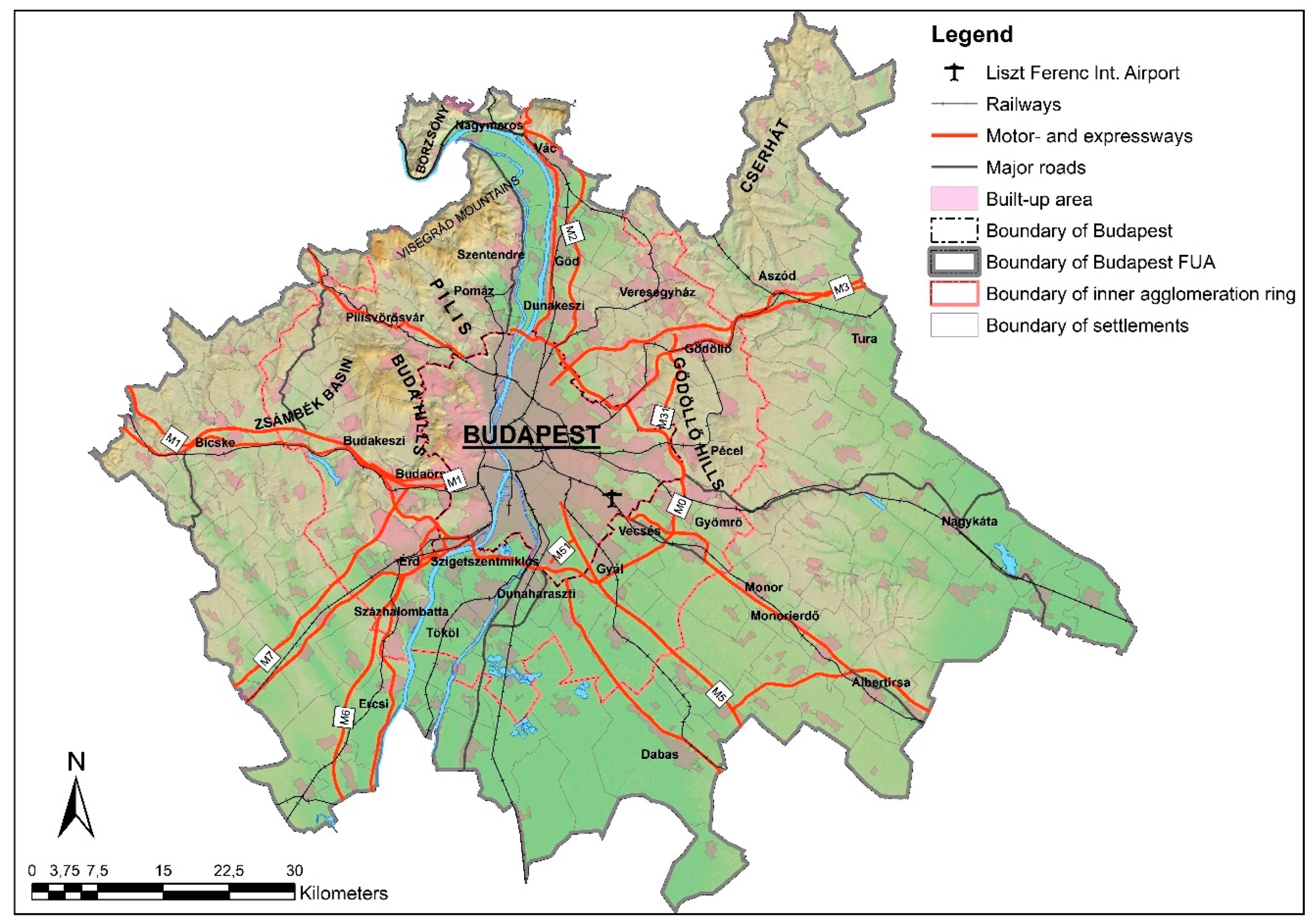
2.1. The Study Area
2.2. Methodological Considerations for Analyzing the Changes from 1959 to 1990
2.3. Methodological Considerations for Analyzing the Changes from 1990 to 2012
- Geometric mismatching caused by different resolutions and geometric accuracy;
- Classification mismatching caused by different classification systems;
- Interpretation mismatching caused by different interpretations of the same categories; and
- Detection mismatching caused by earlier (or later) categorization mistakes.
2.4. Future Predictions with the Use of the Land Change Modeler for ArcGIS
- Neighborhood relations (e.g., distance from the road, built-up areas);
- Natural physical conditions (e.g., elevation, slope, soil type and quality);
- Agricultural indicators (e.g., subsidiaries, potential value from agricultural production, results from the agricultural census); and
- Socioeconomic indicators (e.g., population dynamics, average income).
- The European Environment Agency/Copernicus Land Monitoring Service;
- The Agrotopographic database (AGROTOPO) of the Institute for Soil Sciences and Agricultural Chemistry (TAKI), Hungarian Academy of Sciences;
- Data from the Research Institute of Agricultural Economics;
- The Information System of Natural Protection (TIR);
- The National Adaptation Geo-Information System (NAGiS);
- The Hungarian Central Statistical Office—Inspire database;
- The Hungarian Central Statistical Office—T-STAR (municipality-level database);
- The Hungarian Central Statistical Office—population census;
- The Hungarian Central Statistical Office—agricultural census;
- The National Tax and Customs Administration (NAV) (the Hungarian National Spatial Development and Spatial Information System (TeIR)); and
- The General Transit Feed Specification database of the Centre of Budapest Transport (BKK).
3. Results
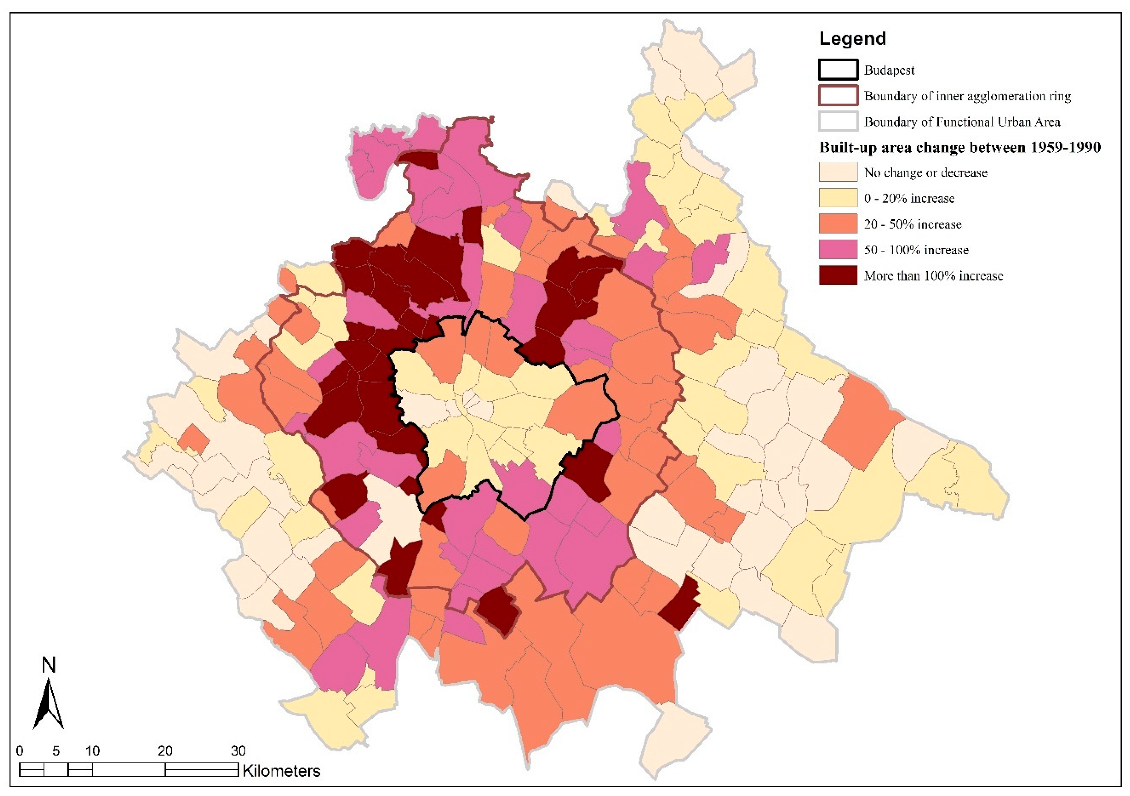
3.1. Land Use Changes during State Socialism (1959–1990)
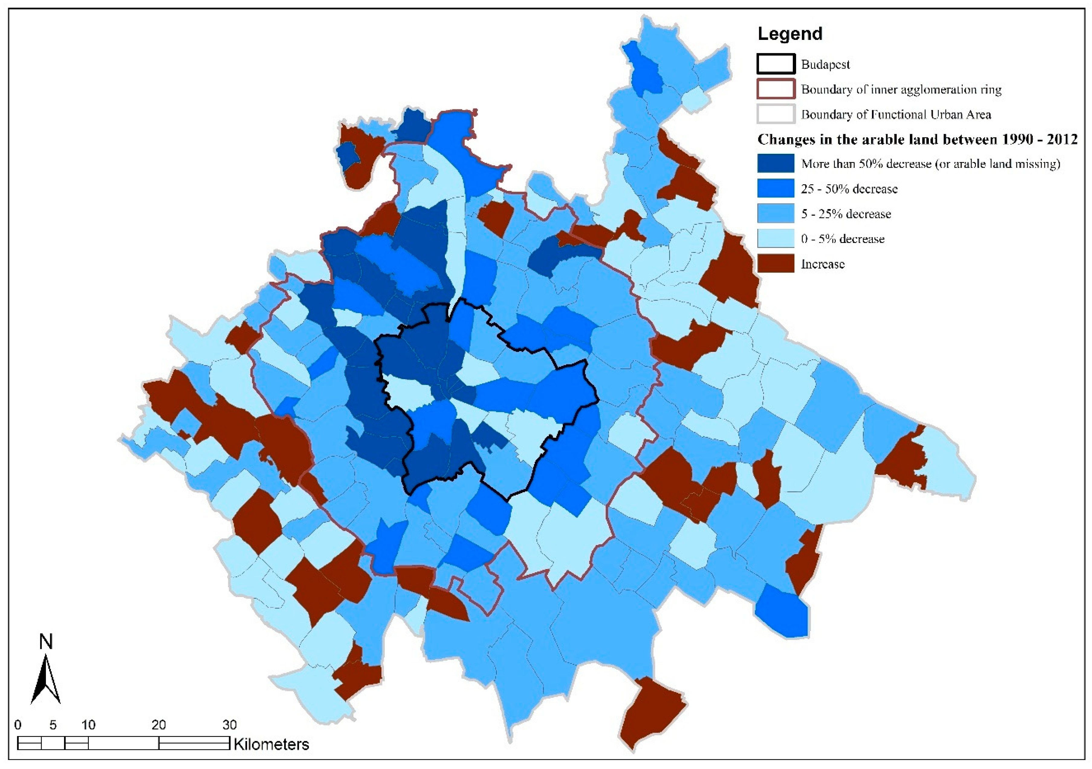
3.2. Land Use Changes after the Political Transition (1990–2012)
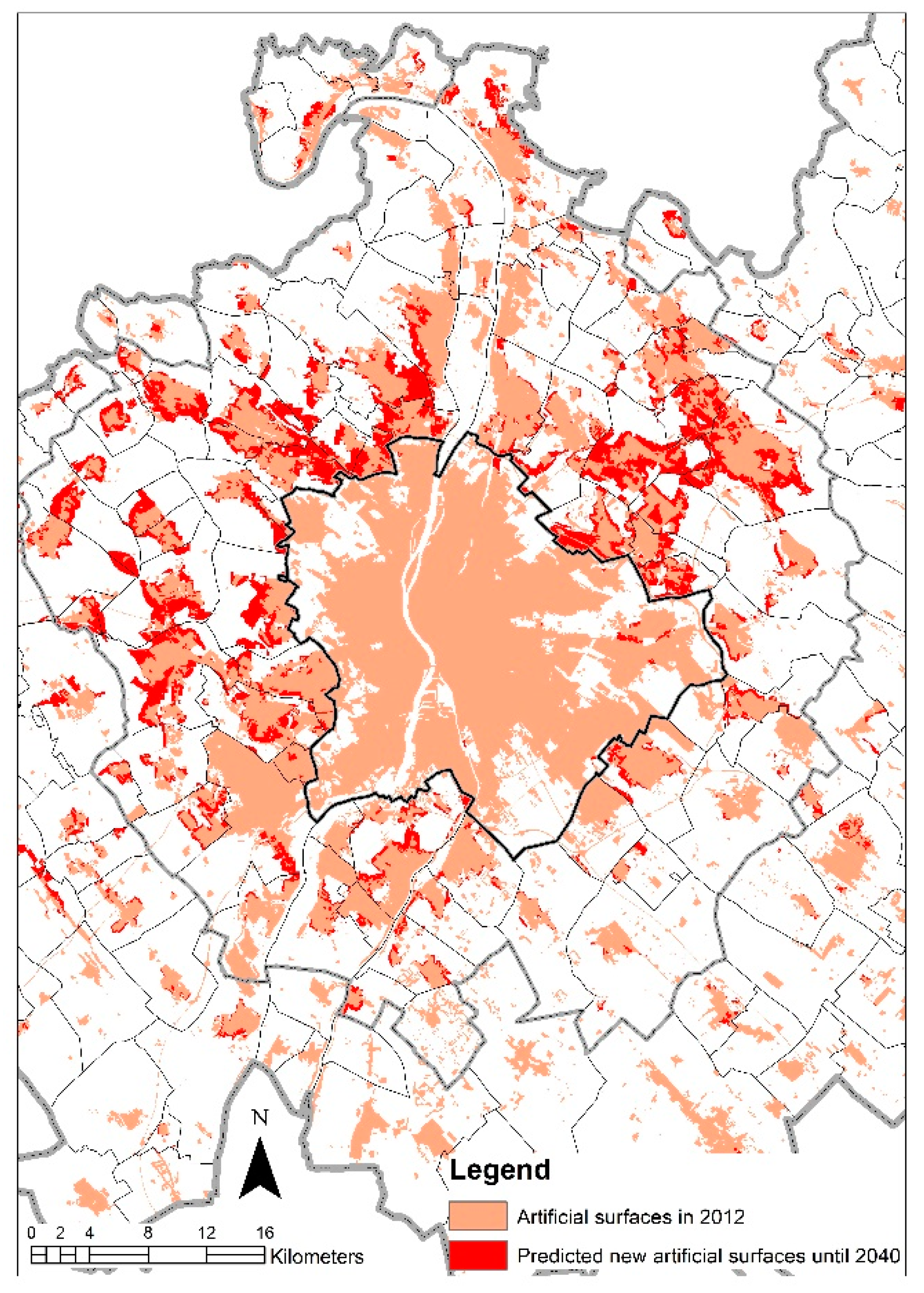
3.3. The Results of the Land Cover Change Forecast (2012–2040)
4. Discussion
- Due to urban sprawl, the extent of artificial surfaces in the FUA of Budapest will increase over time, irrespective of the economic and political system;
- Land conversion will affect different types of agricultural, natural, and seminatural land use cover to varying degrees; and
- The decline in agricultural, natural, and seminatural areas will not be a general phenomenon and will not cover all categories.
4.1. The Continously Expanding Urban Shadow of Budapest
4.2. The Role of Space and Policy
4.3. Grasslands and Forests: Deviations from a General Trend?
4.4. The Aftermarth of Sprawl
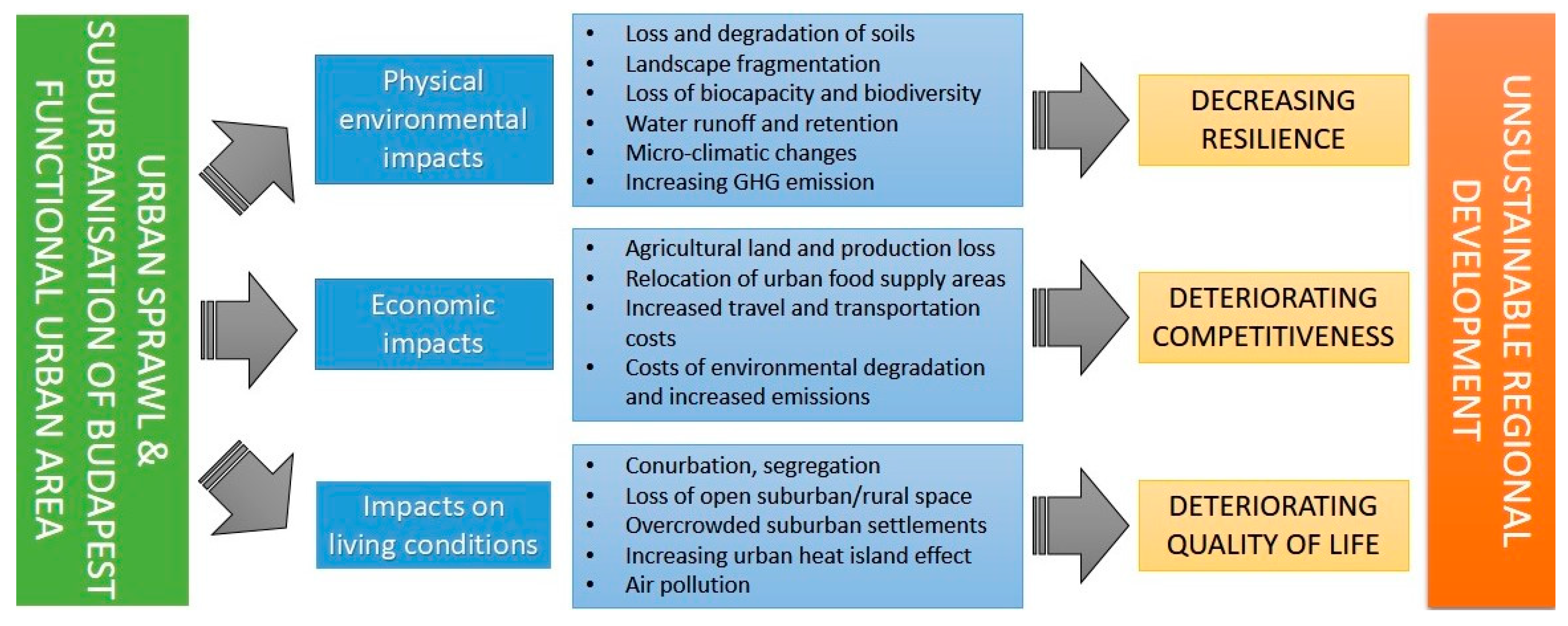
- Sprawl will negatively impact the biological capacity of the agglomeration and reduce carbon sequestration by vegetation and soils;
- It will also reduce the amount of food that can be produced at a given technological level;
- Soil sealing will reduce the utilization of rainfall, help the drainage of water (especially in the hilly areas of the northwest and west of the region), increase the possibility of flash floods and other “havaria” events, and altogether worsen the area’s water management capabilities;
- Open views of landscapes will disappear because of conurbation, and this will also close ecological corridors and cause the fragmentation of habitats and populations;
- The disappearance and degradation of agro-ecosystems will also adversely affect the state of the seminatural ecosystems still present in the area.
4.5. Concluding Remarks
Author Contributions
Funding
Conflicts of Interest
References
- Ewing, R.H. Characteristics, Causes, and Effects of Sprawl: A Literature Review. In Urban Ecology: An International Perspective on the Interaction between Humans and Nature; Marzluff, J.M., Shulenberger, E., Endlicher, W., Alberti, M., Bradley, G., Ryan, C., Simon, U., ZumBrunnen, C., Eds.; Springer: Boston, MA, USA, 2008; pp. 519–535. [Google Scholar]
- Marsden, T.; Sonnino, R. Human health and wellbeing and the sustainability of urban–regional food systems. Curr. Opin. Environ. Sustain. 2012, 4, 427–430. [Google Scholar] [CrossRef]
- Mora, O.; Lançon, F.; Aubert, F. Urban-rural linkages and their future: Impacts on agriculture, diets and food security. Food Security: Meanings, Practices and Policies, Agriculture in an Urbanizing Society. Second International Conference on Agriculture in an Urbanizing Society, Reconnecting Agriculture and Food Chains to Societal Needs: Rome, Italy, 14–17 September 2015. Available online: https://halshs.archives-ouvertes.fr/halshs-01292342 (accessed on 22 September 2019).
- Bren d’Amour, C.; Reitsma, F.; Baiocchi, G.; Barthel, S.; Güneralp, B.; Erb, K.H.; Haberl, H.; Creutzig, F.; Seto, K.C. Future urban land expansion and implications for global croplands. Proc. Natl. Acad. Sci. USA 2017, 114, 8939–8944. [Google Scholar] [CrossRef] [PubMed]
- Anas, A.; Pines, D. Anti-sprawl policies in a system of congested cities. Reg. Sci. Urban Econ. 2008, 38, 408–423. [Google Scholar] [CrossRef]
- Wilson, B.; Chakraborty, A. The Environmental Impacts of Sprawl: Emergent Themes from the Past Decade of Planning Research. Sustainability 2013, 5, 3302. [Google Scholar] [CrossRef]
- Oueslati, W.; Alvanides, S.; Garrod, G. Determinants of urban sprawl in European cities. Urban Stud. 2015, 52, 1594–1614. [Google Scholar] [CrossRef] [PubMed]
- Anas, A.; Arnott, R.; Small, K.A. Urban Spatial Structure. J. Econ. Lit. 1998, 36, 1426–1464. [Google Scholar]
- Brueckner, J.K. Urban Sprawl: Diagnosis and Remedies. Int. Reg. Sci. Rev. 2000, 23, 160–171. [Google Scholar] [CrossRef]
- Johnson, M.P. Environmental Impacts of Urban Sprawl: A Survey of the Literature and Proposed Research Agenda. Environ. Plan. A 2001, 33, 717–735. [Google Scholar] [CrossRef]
- Robinson, L.; Newell, J.P.; Marzluff, J.M. Twenty-five years of sprawl in the Seattle region: Growth management responses and implications for conservation. Landsc. Urban Plan. 2005, 71, 51–72. [Google Scholar] [CrossRef]
- Da Silva Machado, F. Rural change in the context of globalization. Hung. Geogr. Bull. 2017, 66, 43–53. [Google Scholar] [CrossRef]
- Irwin, E.G.; Bockstael, N.E. The evolution of urban sprawl: Evidence of spatial heterogeneity and increasing land fragmentation. Proc. Natl. Acad. Sci. USA 2007, 104, 20672–20677. [Google Scholar] [CrossRef] [PubMed]
- Gutzler, C.; Helming, K.; Balla, D.; Dannowski, R.; Deumlich, D.; Glemnitz, M.; Knierim, A.; Mirschel, W.; Nendel, C.; Paul, C. Agricultural land use changes—A scenario-based sustainability impact assessment for Brandenburg, Germany. Ecol. Indic. 2015, 48, 505–517. [Google Scholar] [CrossRef]
- Lagrosa, J.J.; Zipperer, W.C.; Andreu, M.G. Projecting Land-Use and Land Cover Change in a Subtropical Urban Watershed. Urban Sci. 2018, 2, 11. [Google Scholar] [CrossRef]
- Livanis, G.; Moss, C.B.; Breneman, V.E.; Nehring, R.F. Urban sprawl and farmland prices. Am. J. Agric. Econ. 2006, 88, 915–929. [Google Scholar] [CrossRef]
- Padasas, R. Farming in the Urban Shadow. Agricultural Innovation and Adaptation Strategies in Peri-Urban Valencia and Copenhagen. Master’s Thesis, 4CITIES Master Program, VRIJE Universiteit, Brussels, Belgium, 2019. Available online: https://www.4cities.eu/wp-content/uploads/2019/10/C10_MAthesis_4CITIES_PADASAS_Robern.pdf (accessed on 11 October 2019).
- Cavailhès, J.; Peeters, D.; Sekeris, E.; Thisse, J.F. The periurban city: Why to live between the suburbs and the countryside. Reg. Sci. Urban Econ. 2004, 34, 681–703. [Google Scholar] [CrossRef]
- Coisnon, T.; Oueslati, W.; Salanié, J. Urban Sprawl Occurrence under Spatially Varying Agricultural Bid-Rent and Amenities. Reg. Sci. Urban Econ. 2014, 44, 38–49. [Google Scholar] [CrossRef]
- Piorr, A.; Zasada, I.; Doernberg, A.; Zoll, F.; Ramme, W. Research for AGRI Committee—Urban and Peri-Urban Agriculture in the EU; European Parliament, Policy Department for Structural and Cohesion Policies: Brussels, Belgium, 2018; Available online: http://www.europarl.europa.eu/RegData/etudes/STUD/2018/617468/IPOL_STU(2018)617468_EN.pdf (accessed on 16 November 2019).
- Frumkin, H. Urban sprawl and public health. Public Health Rep. 2002, 117, 201–217. [Google Scholar] [CrossRef]
- Szirmai, V. Urban sprawl in Europe. Reg. Stat. 2012, 2, 129–148. Available online: http://www.ksh.hu/docs/hun/xftp/terstat/2012/RS02109.pdf (accessed on 6 December 2019). [CrossRef]
- Ravetz, J.; Fertner, C.; Nielsen, T.S. The Dynamics of Peri-Urbanization. In Peri-Urban Futures: Scenarios and Models for Land Use Change in Europe; Nilsson, K., Pauliet, S., Bell, S., Aalbers, C., Sick Nielsen, T.A., Eds.; Springer Verlag: Heidelberg, Germany, 2013; pp. 13–44. [Google Scholar] [CrossRef]
- Gumma, M.K.; Irshad, M.; Nedumaran, S.; Whitbread, A.; Lagerkvist, C.J. Urban Sprawl and Adverse Impacts on Agricultural Land: A Case Study on Hyderabad, India. Remote Sens. 2017, 9, 1136. [Google Scholar] [CrossRef]
- Nguyen, H.L.; Duan, J.; Zhang, G.Q. Land Politics under Market Socialism: The State, Land Policies, and Rural–Urban Land Conversion in China and Vietnam. Land 2018, 7, 51. [Google Scholar] [CrossRef]
- Couch, C.; Leontidou, L.; Petschel-Held, G. (Eds.) Urban Sprawl in Europe: Landscapes, Land-Use Change and Policy; Blackwell Publishing: Oxford, UK, 2007. [Google Scholar]
- Patacchini, E.; Zenou, Y. Urban sprawl in Europe. Brook. Whart. Pap. Urban Aff. 2009, 10, 125–149. [Google Scholar]
- Arribas-Bel, D.; Nijkamp, P.; Schoelten, H. Multidimensional urban sprawl in Europe: A self-organizing map approach. Comput. Environ. Urban Syst. 2011, 35, 265–275. Available online: https://spinlab.vu.nl/wp-content/uploads/2016/09/ERSA2010finalpaper485.pdf (accessed on 16 August 2019). [CrossRef]
- Christiansen, P.; Loftsgarden, L. Drivers behind urban sprawl in Europe; Institute of Transport Economics Report, Norwegian Centre for Transport Research: Oslo, Norway, 2011; Available online: https://www.toi.no/getfile.php/1317329/Publikasjoner/T%C3%98I%20rapporter/2011/1136-2011/1136-2011-el.pdf (accessed on 1 October 2019).
- Guastella, G.; Oueslati, W.; Pareglio, S. Patterns of Urban Spatial Expansion in European Cities. Sustainability 2019, 11, 2247. [Google Scholar] [CrossRef]
- Marsden, T.K.; Munton, R.J.C.; Whatmore, S.J.; Little, J.K. Towards a political economy of capitalist agriculture: A British perspective. Int. J. Urban Reg. Res. 1986, 10, 498–521. [Google Scholar] [CrossRef]
- Lowe, P.; Murdoch, J.; Marsden, T.; Munton, R.; Flynn, A. Regulating the new rural spaces: The uneven development of land. J. Rural Stud. 1993, 9, 205–222. [Google Scholar] [CrossRef]
- Freshwater, D. Maintaining Farmland: A New Focus for Agricultural Policy. In Multifunctionality in Agriculture, Evaluating the Degree of Jointness, Policy Implications; OECD Publishing: Paris, France, 2008; pp. 47–64. [Google Scholar] [CrossRef]
- Allen, A. Environmental planning and management of the peri-urban interface: Perspectives on an emerging field. Environ. Urban. 2003, 15, 135–147. [Google Scholar] [CrossRef]
- Seto, K.C.; Sánchez-Rodríguez, R.; Fragkias, M. The new geography of contemporary urbanization and the environment. Annu. Rev. Environ. Resour. 2010, 35, 167–194. [Google Scholar] [CrossRef]
- Rauws, W.S.; de Roo, G. Exploring transitions in the peri-urban area. Plan. Theory Pract. 2011, 12, 269–284. [Google Scholar] [CrossRef]
- Caruso, G.; Cavailhès, J.; Peeters, D.; Rounsevell, M.; Thomas, I. Peri-Urbanisation: The Situation in Europe. A Bibliographical Note and Survey of Studies in the Netherlands, Belgium, Great Britain, Germany, Italy and the Nordic Countries; Report prepared for DATAR, Ministère de l’Aménagement du Territoire et de l’Environnement, France; Département d’Economie et Sociologie Rurale Institut National de Recherche Agronomique (INRA): Dijon, France, 2001; Available online: https://orbilu.uni.lu/bitstream/10993/10153/1/Caruso_PeriUrbanEuropeDATAR.pdf (accessed on 14 September 2019).
- Hatna, E.; Bakker, M.M. Abandonment and Expansion of Arable Land in Europe. Ecosystems 2011, 14, 720–731. [Google Scholar] [CrossRef]
- Piorr, A.; Ravetz, J.; Tosics, I. Peri-Urbanisation in Europe: Towards European Policies to Sustain Urban Rural Futures; A Synthesis Report; Academic Books: Frederiksberg, Denmark, 2011; Available online: http://www.openspace.eca.ed.ac.uk/wp-content/uploads/2015/12/Peri_Urbanisation_in_Europe_printversion.pdf (accessed on 24 September 2019).
- Mazzocchi, C.; Sali, G.; Corsi, S. Land use conversion in metropolitan areas and the permanence of agriculture: Sensitivity Index of Agricultural Land (SIAL), a tool for territorial analysis. Land Use Policy 2013, 35, 155–162. [Google Scholar] [CrossRef]
- European Environment Agency (EEA). Urban Sprawl in Europe—The Ignored Challenge; EEA Report No 10/2006; European Environment Agency: Copenhagen, Denmark, 2006; Available online: https://www.eea.europa.eu/publications/eea_report_2006_10 (accessed on 22 September 2019).
- Karwińska, A.; Böhm, A.; Kudłacz, M. The phenomenon of urban sprawl in modern Poland: Causes, effects and remedies. Public Gov. Zarządzanie Publiczne 2018, 3, 26–43. [Google Scholar] [CrossRef]
- Kubeš, J. European post-socialist cities and their near hinterland in intra-urban geography literature. Bull. Geogr. Socio-Econ. Ser. 2013, 19, 19–43. [Google Scholar] [CrossRef]
- Lityński, P.; Hołuj, A. Urban Sprawl Costs: The Valuation of Households’ Losses in Poland. J. Settl. Spat. Plan. 2017, 1, 11–35. [Google Scholar] [CrossRef]
- Slaev, A.D.; Nedović-Budić, Z.; Krunić, N.; Petrić, J.; Daskalova, D. Suburbanization and sprawl in post-socialist Belgrade and Sofia. Eur. Plan. Stud. 2018, 7, 1389–1412. [Google Scholar] [CrossRef]
- Schmidt, S.; Fina, S.; Siedentop, S. Post-socialist Sprawl: A Cross-Country Comparison. Eur. Plan. Stud. 2015, 7, 1357–1380. [Google Scholar] [CrossRef]
- Kovács, Z. Városok és urbanizációs kihívások Magyarországon [Cities and Challenges of Urbanisation in Hungary]. Magy. Tudomány 2017, 178, 302–310. [Google Scholar]
- Kovács, Z.; Farkas, Z.J.; Egedy, T.; Kondor, A.C.; Szabó, B.; Lennert, J.; Baka, D.; Kohán, B. Urban sprawl and land conversion in post-socialist cities: The case of metropolitan Budapest. Cities 2019, 92, 71–81. [Google Scholar] [CrossRef]
- Locsmándi, G. Large-scale restructuring processes in the urban space of Budapest. In Urban Models and Public-Private Partnership; Dalla Long, R., Ed.; Springer: Berlin/Heidelberg, Germany, 2011; pp. 131–212. [Google Scholar] [CrossRef]
- Farkas, J.Z.; Lennert, J. Future Prospects of Land Cover Change in Hungary: Modelling and Forecasts. In Three Decades of Transformation in the East-Central European Countryside; Bański, J., Ed.; Springer: Cham, Switzerland, 2019; pp. 309–333. [Google Scholar]
- Kajner, P.; Czira, T.; Selmeczi, P.; Sütő, A. National Adaptation Geo-information System in climate adaptation planning. IDŐJÁRÁS Q. J. Hung. Meteorol. Serv. 2017, 121, 329–477. Available online: https://www.met.hu/downloads.php?fn=/metadmin/newspaper/2017/12/179c074942dd43b8825bd590e14aebbd-121-4-2-kajner.pdf (accessed on 18 February 2020).
- Egedy, T.; Kovács, Z.; Kondor, A. Metropolitan region building and territorial development in Budapest: The role of national policies. Int. Plan. Stud. 2017, 22, 14–29. [Google Scholar] [CrossRef]
- Beluszky, P. Az elővárosok útja Nagy-Budapesthez [The road to Great-Budapest]. In Az Ötven Éves Nagy-Budapest–Előzmények és Megvalósulás [The Fifty-Year-Old Great-Budapest—Precedings and Formation]; Hollósi, S.A., Sipos, A., Eds.; Budapesti Történeti Múzeum: Budapest, Hungary, 2002; Tanulmányok Budapest múltjából [Historical studies of Budapest]; Volume 30, pp. 121–152. [Google Scholar]
- Kovács, Z. A City at the Crossroads: Social and Economic Transformation in Budapest. Urban Stud. 1994, 31, 1081–1096. [Google Scholar] [CrossRef]
- Berényi, I. Conflicts in land use in suburbia: The example of Budapest. In The Take-off of Suburbia and the Crisis of the Central City: Proceedings of the International Symposium in Munich and Vienna 1984; Heinritz, G., Lichtenberger, E., Eds.; Steiner Verlag Wiesbaden: Stuttgart, Germany, 1986; pp. 125–134. [Google Scholar]
- Bódi, F.; Savova, R. A bolgárkertészek Magyarországon a 19. század végén és a 20. század első felében—Környezeti és gazdaságantropológiai aspektusból [Bulgarian Market-gardeners in Hungary at the End of the 19th Century and in the First Part of the 20th Century. Ecological and Economic Anthropology Aspects]. Magy. Tudomány 2018, 179, 373–382. [Google Scholar]
- Seifert, F.M. Improving urban monitoring toward a European Urban Atlas. In Global Mapping of Human Settlement: Experiences, Datasets, and Prospects; Gamba, P., Herold, M., Eds.; CRC Press: Boca Raton, FL, USA, 2009; pp. 231–248. [Google Scholar] [CrossRef]
- Bossard, M.; Feranec, J.; Otahel, J. CORINE land Cover Technical Guide—Addendum 2000; Technical Report No 40; European Environment Agency: Copenhagen, Denmark, 2000; Available online: https://land.copernicus.eu/user-corner/technical-library/tech40add.pdf (accessed on 1 February 2020).
- Feranec, J.; Hazeu, G.; Christensen, S.; Jaffrain, G. Corine land cover change detection in Europe (case studies of the Netherlands and Slovakia). Land Use Policy 2007, 24, 234–247. [Google Scholar] [CrossRef]
- Büttner, G.; Bíró, M.; Maucha, G.; Petrik, O. Land Cover mapping at scale 1:50:000 in Hungary: Lessons learnt from the European CORINE programme. In A Decade of Trans-European Remote Sensing Cooperation; Buchroithner, M.F., Ed.; Balkema: Rotterdam, The Netherlands, 2001; pp. 25–31. [Google Scholar]
- García, P.; Eugenia, P. Mapping of soil sealing by vegetation indexes and built-up index: A case study in Madrid (Spain). Geoderma 2016, 268, 100–107. [Google Scholar] [CrossRef]
- Mucsi, L.; Liska, C.M.; Henits, L.; Tobak, Z.; Csendes, B.; Nagy, L. The evaluation and application of an urban land cover map with image data fusion and laboratory measurements. Hung. Geogr. Bull. 2017, 66, 145–156. [Google Scholar] [CrossRef]
- Olmedo, M.T.C.; Gilmore, R.; Paegelow, M.; Mas, J.F. Environmental modelling & software comparison of simulation models in terms of quantity and allocation of land change. Environ. Model. Softw. 2015, 69, 214–221. [Google Scholar] [CrossRef]
- Anand, J.; Gosain, A.K.; Khosa, R. Prediction of land use changes based on Land Change Modeler and attribution of changes in the water balance of Ganga basin to land use change using the SWAT model. Sci. Total Environ. 2018, 644, 503–519. [Google Scholar] [CrossRef]
- Silva, L.P.; Xavier, A.P.C.; Silva, R.M.; Santos, C.A.G. Modeling land cover change based on an artificial neural network for a semiarid river basin in northeastern Brazil. Glob. Ecol. Conserv. 2020, 21, e00811. [Google Scholar] [CrossRef]
- Martellozzo, F.; Amato, F.; Murgante, B.; Clarke, K.C. Modelling the impact of urban growth on agriculture and natural land in Italy to 2030. Appl. Geogr. 2018, 91, 156–167. [Google Scholar] [CrossRef]
- Lennert, J. A magyar vidék demográfiai jövőképe 2051-ig, különös tekintettel a klímaváltozás szerepére a belső vándormozgalom alakításában [Demographic scenarios for the Hungarian rural areas with consideration to the effects of climate change]. Területi Stat. 2019, 59, 498–525. [Google Scholar] [CrossRef]
- Jacob, D.; Petersen, J.; Eggert, B.; Alias, A.; Christensen, O.B.; Bouwer, L.M.; Braun, A.; Colette, A.; Déqué, M.; Georgievski, G.; et al. EURO-CORDEX: New high-resolution climate change projections for European impact research. Reg. Environ. Chang. 2014, 14, 563–578. [Google Scholar] [CrossRef]
- Sangermano, F.; Toledano, J.; Eastman, J.R. Land cover change in the Bolivian Amazon and its implications for REDD+ and endemic biodiversity. Landsc. Ecol. 2012, 27, 571–584. [Google Scholar] [CrossRef]
- Budapesti Agglomeráció Szerkezeti terve [Structural Plan of Budapest Agglomeration]. Lechner Tudásközpont, Budapest. 2018. Available online: https://www.e-epites.hu/sites/default/files/csatolmanyok/7_budapesti_agglomeracio_szerkezeti_terve.pdf (accessed on 1 February 2020).
- Preisich, G. A budapesti településagglomeráció növekedése és az ebből eredő problémák [The growth of Budapest agglomeration and the resulting problems]. Demográfia 1968, 11, 201–221. [Google Scholar]
- Lisowski, A.; Mantey, D.; Wilk, W. Lessons from Warsaw: The Lack of Coordinated Planning and Its Impacts on Urban Sprawl. In Confronting Suburbanization: Urban Decentralization in Postsocialist Central and Eastern Europe 2014; Stanilov, K., Luděk, S., Eds.; John Wiley & Sons: Chichester, United Kingdom, 2014; pp. 225–255. [Google Scholar]
- Timár, J.; Váradi, M. The uneven development of suburbanization during transition in Hungary. Eur. Urban Reg. Stud. 2001, 8, 349–360. [Google Scholar] [CrossRef]
- Tóth, K.; Koós, B. Párhuzamos történetek? Lakóhelyi és gazdasági szuburbanizáció [Parallel Stories? Residential and economic suburbanization]. In Táj, Tér, Tervezés. Geográfus Doktoranduszok VIII. Országos Konferenciája [Land, Space, Planning. The 8th National Conference of Geography PhD Students]; Barton, G., Dormány, G., Kovács, F., Eds.; University of Szeged: Szeged, Hungary, 2004; p. 17. Available online: http://geography.hu/mfk2004/mfk2004/phd_cikkek/toth_koos.pdf (accessed on 1 February 2020).
- Ahrens, A.; Lyons, S. Changes in Land Cover and Urban Sprawl in Ireland From a Comparative Perspective Over 1990–2012. Land 2019, 8, 16. [Google Scholar] [CrossRef]
- Bański, J. The consequences of changes of ownership for agricultural land use in Central European countries following the collapse of the Eastern Bloc. Land Use Policy 2017, 66, 120–130. [Google Scholar] [CrossRef]
- Csatári, B.; Farkas, J.Z.; Lennert, J. Agrarian and Rural Development in Hungary after 1989. In Three Decades of Transformation in the East-Central European Countryside; Bański, J., Ed.; Springer: Cham, Switzerland, 2019; pp. 21–54. [Google Scholar]
- Alonso, W. Location and Land Use. In Toward a General Theory of Land Rent; Cambridge, Harvard University Press: Cambridge, UK, 1964. [Google Scholar] [CrossRef]
- Nonhebel, S. Options and trade-offs: Reducing greenhouse gas emissions from food production systems. In Agriculture and Climate beyond 2015; Environment & Policy; Brouwer, F., McCarl, B.A., Eds.; Springer: Dordrecht, The Netherlands, 2006; Volume 46, pp. 211–230. [Google Scholar] [CrossRef]
- Sinclair, R. Von Thünen and urban sprawl. Ann. Assoc. Am. Geogr. 1967, 57, 72–87. [Google Scholar] [CrossRef]
- Tammaru, T.; Leetmaa, K.; Silm, S.; Ahas, R. Temporal and spatial dynamics of the new residential areas around Tallinn. Eur. Plan. Stud. 2009, 17, 423–439. [Google Scholar] [CrossRef]
- Kubeš, J.; Nováček, A. Suburbs around the Czech provincial city of České Budějovice—Territorial arrangement and problems. Hung. Geogr. Bull. 2019, 68, 65–78. [Google Scholar] [CrossRef]
| Land Use Category | Share from the New Built-Up Zones (%) |
|---|---|
| Arable land | 34.27 |
| Vineyards | 17.17 |
| Orchards and berry plantations | 5.77 |
| Pastures | 14.45 |
| Complex cultivation patterns | 14.66 |
| Agriculture subtotal | 86.32 |
| Forests | 5.10 |
| Other | 8.58 |
| Total | 100.00 |
| Land Use Category | Share from the New Built-Up Zones (%) |
|---|---|
| Arable land | 42.67 |
| Vineyards | 6.07 |
| Orchards and berry plantations | 1.85 |
| Pastures | 9.29 |
| Complex cultivation patterns | 26.65 |
| Agriculture subtotal | 86.53 |
| Forests | 11.78 |
| Other | 1.69 |
| Total | 100.00 |
| Land Use Category | Share from the New Built-Up Zones (%) |
|---|---|
| Arable land | 40.52 |
| Vineyards | 4.04 |
| Orchards and berry plantations | 0.12 |
| Pastures | 15.72 |
| Complex cultivation patterns | 23.32 |
| Agriculture subtotal | 83.72 |
| Forests | 15.52 |
| Other | 0.75 |
| Total | 100.00 |
© 2020 by the authors. Licensee MDPI, Basel, Switzerland. This article is an open access article distributed under the terms and conditions of the Creative Commons Attribution (CC BY) license (http://creativecommons.org/licenses/by/4.0/).
Share and Cite
Lennert, J.; Farkas, J.Z.; Kovács, A.D.; Molnár, A.; Módos, R.; Baka, D.; Kovács, Z. Measuring and Predicting Long-Term Land Cover Changes in the Functional Urban Area of Budapest. Sustainability 2020, 12, 3331. https://doi.org/10.3390/su12083331
Lennert J, Farkas JZ, Kovács AD, Molnár A, Módos R, Baka D, Kovács Z. Measuring and Predicting Long-Term Land Cover Changes in the Functional Urban Area of Budapest. Sustainability. 2020; 12(8):3331. https://doi.org/10.3390/su12083331
Chicago/Turabian StyleLennert, József, Jenő Zsolt Farkas, András Donát Kovács, András Molnár, Rita Módos, Dorián Baka, and Zoltán Kovács. 2020. "Measuring and Predicting Long-Term Land Cover Changes in the Functional Urban Area of Budapest" Sustainability 12, no. 8: 3331. https://doi.org/10.3390/su12083331
APA StyleLennert, J., Farkas, J. Z., Kovács, A. D., Molnár, A., Módos, R., Baka, D., & Kovács, Z. (2020). Measuring and Predicting Long-Term Land Cover Changes in the Functional Urban Area of Budapest. Sustainability, 12(8), 3331. https://doi.org/10.3390/su12083331


