1. Introduction
The current situation in many parts of the world has consisted of a trend of continuous territorial degradation resulting in an inability to manage changes, which tend to occur more frequently, a decrease in the availability of resources, and a decline in the general well-being of the populations [
1,
2,
3,
4,
5,
6,
7]. Integrating natural processes into built areas is increasingly considered as a challenge to territorial planning [
8,
9]. The concept of nature-based solutions needs to be introduced to highlight the importance of conservation and the sustainable use of natural ecosystems and biodiversity for climate change mitigation, natural disasters, and adaptation [
9,
10,
11,
12,
13]. It also constitutes a sustainable and economically viable alternative, often more cost-effective the long term than technology investments or the construction and maintenance of infrastructures [
14].
It can also contribute to preserving biodiversity, mostly by preventing soil artificialisation, which is a significant cause of soil erosion and greenhouse gas emissions [
15]; in the end, through ecosystem services, it provides substantial benefits to human well-being. In the context of sustainable development and to provide meaningful results, this approach and its solutions must be implemented at a landscape scale and on a long-term basis.
As [
9] pointed out, nature-based solutions involve three types of actions implemented at the regional and local levels:
Preserving the integrity and functional ecological status of ecosystems;
Improving sustainable management of ecosystems affected by human activities;
Restoring degraded ecosystems or creating new ecosystems.
These approaches include ecological restoration, ecological engineering, forest landscape restoration, ecosystem-based adaptation, ecosystem-based mitigation, ecosystem-based disaster risk reduction, green infrastructure, ecosystem-based management, and various area-based conservation approaches such as protected area management [
9,
16,
17].
Nature-based solutions go beyond the traditional biodiversity conservation and management principles by “re-focusing” the debate on humans and by integrating societal factors such as human well-being and poverty alleviation, socioeconomic development, and governance principles.
Green infrastructures (GIs) are nature-based solutions that can help societies to address a range of environmental, social, and economic challenges sustainably. Green infrastructures aim to establish a natural continuum that uses nature as a means for providing ecosystem services such as water and air purification, and biodiversity, among others, and, concurrently, offers long-term answers to the issues arising from climate change [
16]. Also, GI contributes to encouraging connectivity besides functionality; connectivity is indeed a trigger of sustainable and resilient urban forms. Green infrastructures offer multiple benefits and have a clear social function because they provide spaces for recreation and leisure [
18,
19,
20]. These infrastructures also provides benefits in climate change mitigation and adaptation of urban areas to environmental change [
21,
22,
23].
Green infrastructure also contributes to connectivity as a trigger for sustainability and resilient urban forms, providing cities—from macro to micro scale—with enhanced biodiversity, improved hydrological processes, and healthier life [
24,
25,
26,
27].
In the last decades, several cities and regions around the world have adopted policies to manage urban sprawl and protect existing natural areas. These policies aim to implement green infrastructures that have been described and defined as greenbelts, greenways, and ecological networks [
28,
29,
30,
31,
32]. These areas not only promote biodiversity but also generate other environmental and social benefits to the urban environment, as discussed above [
28,
33,
34,
35,
36,
37]. However, the implementation of GI in urban areas is a complex process and requires the integration of political, social, economic, and environmental issues through a cross-disciplinary planning process.
A well-planned GI helps in creating sustainable communities as well as providing critical ecosystem services to stronger and progressively more resilient, and therefore less vulnerable, communities [
38]. This concept is gaining acceptance as a crucial element in the evolution of sustainable cities [
17,
39,
40,
41].
In the African context, this rapid urbanisation will inevitably result in unplanned expansion, with massive impacts on the environment. This growth has resulted in negative social, economic, and environmental consequences with negative environmental impacts related to the occupation of hazard-prone areas. These areas, such as floodplains, steep slopes, riverbanks or coastal locations, are critical in dealing with extreme weather events. Integrating the green infrastructures in local and regional planning instruments will be essential to prevent future hazards and to promote the well-being of the urban population [
42].
The nonexistence of planning (and appropriate information) allows the expansion of areas without infrastructures. Its consequence is the origin of environmental problems and a substantial loss of quality of the natural areas. The reality affects a critical part of the population who live in those areas. From it evolves the need to consider green infrastructure as a critical factor in the planning process, as an immutable factor or as a strong commitment to sustainable development [
43,
44,
45].
The desirable approach is to combine the cities’ challenges through the creation of GI and an integrated approach [
17]. Green infrastructures can help to avoid fragmentation and urbanisation sprawl, and create a virtual circle that promotes integration [
43]. GI has the potential to unlock more resourceful paths for sustainable, green, and inclusive urban development [
44].
If green infrastructures contribute to health aspects and improve the socioeconomic conditions of communities through an integrated approach [
36], research shows that differences in objectives and outcomes can be attributed to specific countries’ spatial planning approaches [
45]. The use of land with GI contributes to the potential use of natural resources and reduces the flooding risk in urban informal settlements and is a partial help of capital as increases the potential to community development [
46].
The research on green infrastructures in Africa highlights that frameworks must recognize the distinctive characteristics of African urban areas and integrate the socio-ecological systems [
47].
In the African context, two schools of thought are robustly negotiated, considering conservation of nature on the one hand, and urban development for growth on the other [
48].
Africa’s ecosystems can serve as foundations for green infrastructure to serve the needs of its urban populations while safeguarding fragile biodiversity [
49]. Poorer areas have lower GI in South Africa, so residents of medium and small urban areas are available to improve and participate in the maintenance of GI [
50].
Improved infrastructure can deliver major benefits capable of achieving the Sustainable Development Goal. Green and grey infrastructure integration and social inclusiveness are recognized to a very limited degree in planning documents and in practice [
51]. Informal settlements in Nairobi (Kenya) can benefit from green and blue infrastructure (GI), so a robust design is needed to assure the contribution to development and valorization of GI [
52].
There is a need for more context-specific social and health research [
45] and context-based planning based on the unique considerations [
48]. The research shows the need for empirical evidence to help inform decision-making and the development of theory on the social and ecological dimensions of urban and ecosystem services in Africa [
47] and a transfer of the main principles of urban green infrastructure such as, information, decision-supporting and technical tools into practice [
51].
Angola and Luanda (as have other cities) have important challenges of sprawl and the occupation of flood areas and green areas, to create a city compact, integrate GI using different levels of information. This gap identified in the planning process is the research question and the theoretical support to the development of a method to apply in planning nature-based solutions.
The aim of this paper is planning a GI linking biophysical, social, and legal contents in a specific African country with an approach that links different scales and different levels of data and information. This goal could assure that nature conservation, biodiversity, and nature-based solutions and services are implemented through the green infrastructure of a metropolitan.
2. Research Methodology
2.1. Approach
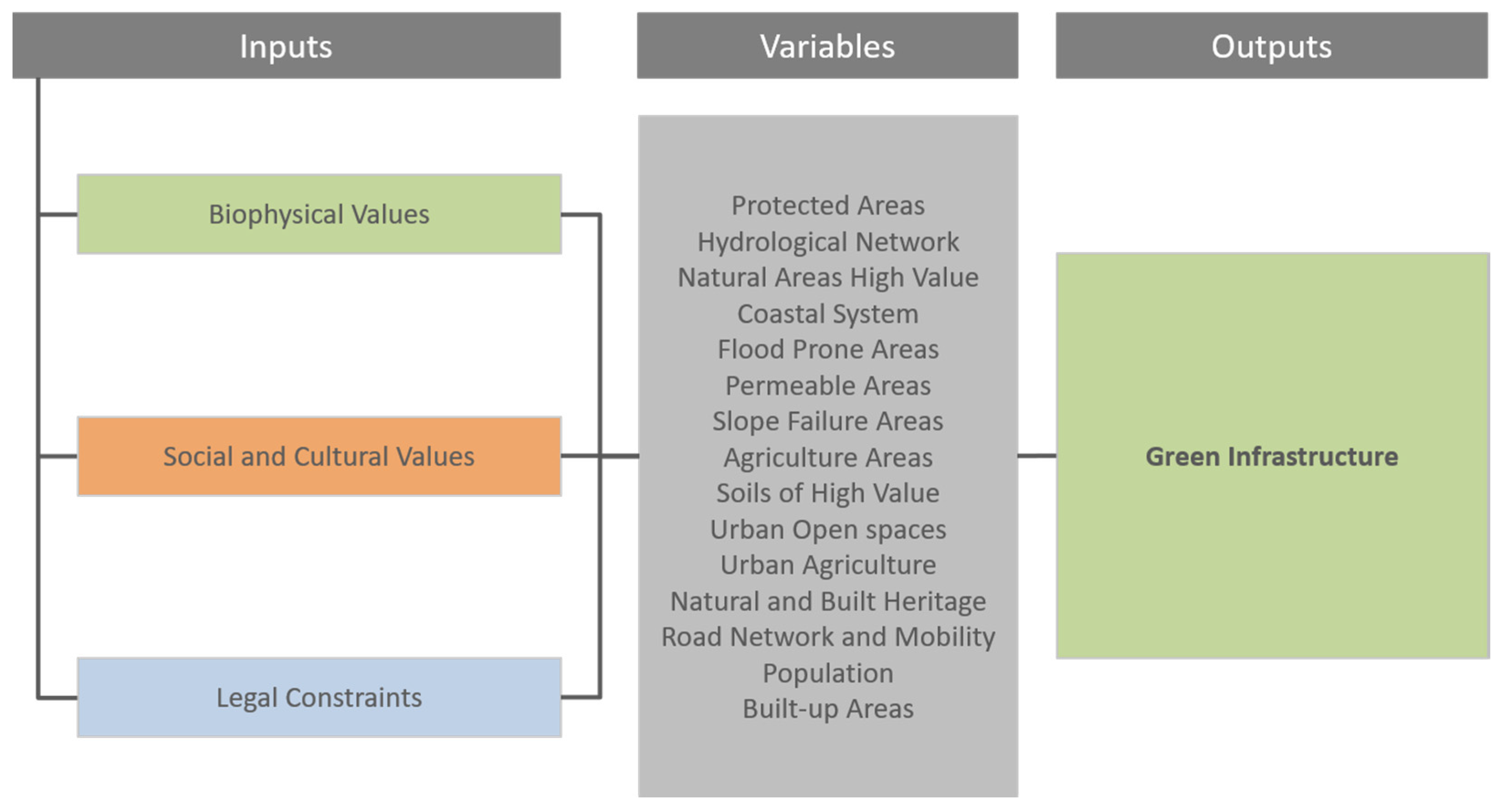
The methodological approach used in the research consisted of adapting the scales in the green infrastructure concept to a framework that links biophysical, social, and legal contents with different sources and levels of information. The method gave support to the operative process, which considered parametric elements by way of a graphical user interface that allowed us to better identify the mapping of the area limit.
The use of different scales in GI areas have support in the fundamental ecosystem functions and in their protection of the sustainability of the territory. The green infrastructure also includes areas of local importance, such as agricultural lands, intermittent watercourses, and their banks, which constitute essential ecological corridors, especially in an urban context.
In urban areas, the identification of green corridors is of high relevance due to the existing pressures and discontinuities resulting from inadequate urban planning. This local level of the GI attempts to fulfil the need for public recreational spaces while at the same time promoting biodiversity in the urban environment and also including elements of cultural and built heritage as part of its structure.
This network creates green infrastructure corridors that establish links and continuity of spaces, essential from both an ecological and a recreational point of view [
53]. One of its main strategies focuses on the sustainable management of urban stormwater, which contributes to the mitigation of hazards such as flood and slope failure. In this study, a lack of baseline information and the overall regional scale of the project did not allow the definition of an urban scale complementary green infrastructure (
Figure 1).
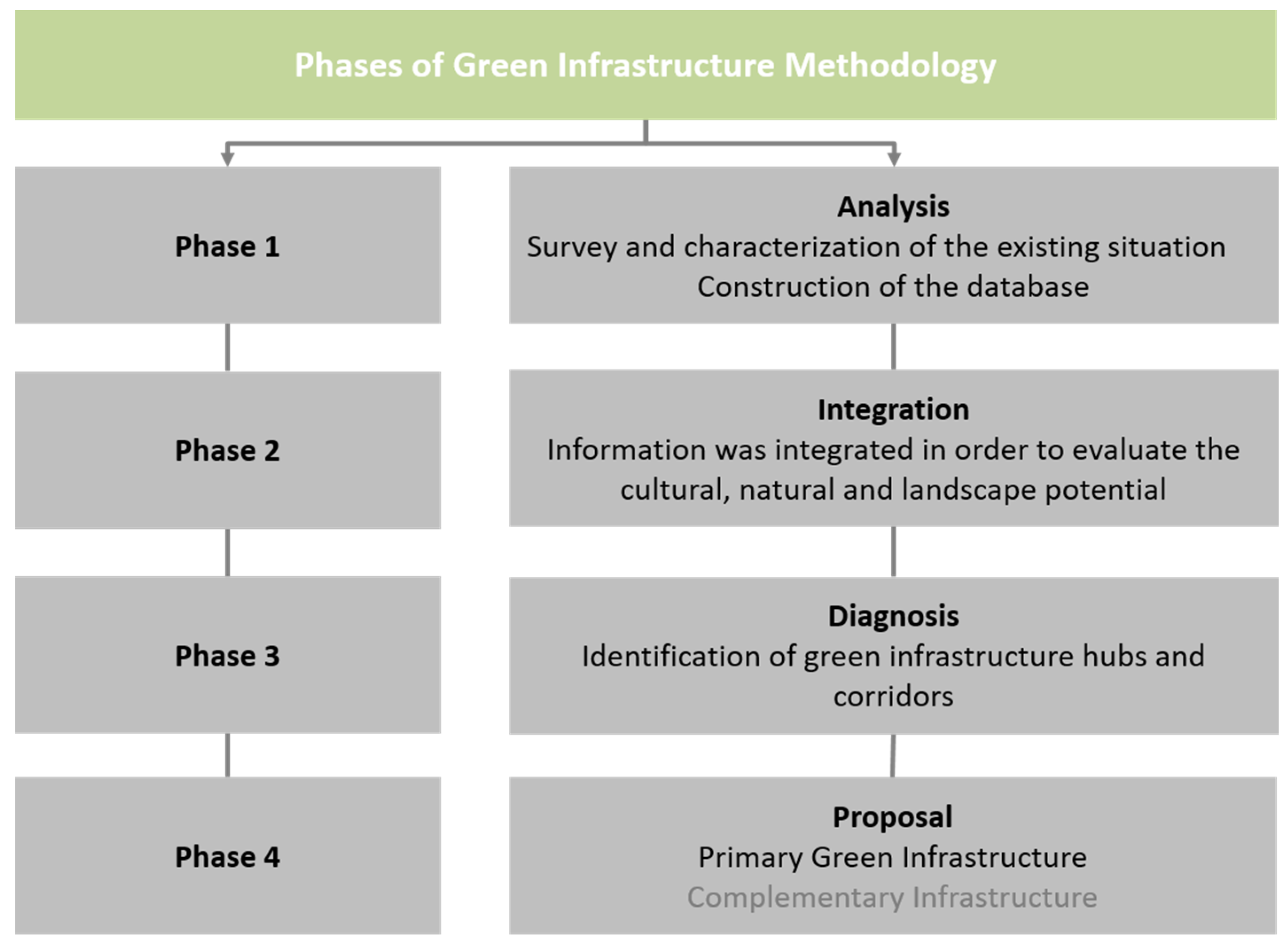
2.2. Operative Process
The methodology to define the GI was implemented by an operative process with four phases, all supported by the use of GIS, according to its role of prime importance (
Figure 2):
Phase 1 (Analysis) Information on the study of the metropolitan area was collected and processed; three sets of fundamental variables were considered: biophysical, social, and legal constraints. These data allowed an explicit knowledge and image of the natural and artificial situations of the territory and uses.
Phase 2 (Integration) Variables related to evaluating the cultural, natural, and landscape potential of the territory were listed. In this phase, the most relevant areas for conservation or restoration were prioritised, according to their relative ecological importance and risk of potential losses, which allowed identifying the value classification of immutable areas needing protection or rehabilitation.
Phase 3 (Diagnosis) Intersections between the different variables worked by Boolean intersections of spatial attributes were carried out in a GIS environment. The result in the first spatial outlines of the green infrastructure, in particular, were the key areas to function as anchors.
Phase 4 (Proposal) This was accomplished at a regional scale and consisted of the proposal of the primary green infrastructure (local level). As stated earlier, the complementary green infrastructure was not presented at this stage because information relating to some of its elements was not available.
As explained, African countries, unlike European or North American countries, struggle with up-to-date and reliable data information at the appropriate scale. The lack of access to appropriate resources and of local capacities to begin data analysis was one of the major challenges that this methodological approach could start to help. It was a challenge to have frequent updates of data, which were required to keep up with the changes in the territory. The significant problems detected in similar cases were, beyond lack of information data, the lack of local capacity and expertise, the lack of local knowledge of socio-cultural values, the lack of management and coordination at different scales.
Such limitations of the baseline data maps were particularly meaningful at the lower scales, affecting the input and output possibilities of this research. But this methodological approach allows the addition of necessary elements over time when making a comprehensive mapping survey and studies. As more detailed information becomes available, through better satellite images or topographical surveys, these types of areas will be integrated into the GI. The variables such as intermittent watercourses, urban open spaces, and tree-lined streets have been identified and mapped by visual surveys. The software packages used to interrelate different variables into a spatial framework were ArcGIS 10.2 (ESRI) and Quantum GIS 2.16 Nødebo.
During Phase 3, the hubs and the corridors were identified. Hubs, in this work, were defined as contiguous areas of significant ecological importance, but may also include a variety of land uses, forms, and shapes, including the core zone and the surrounding protection buffer. These hubs can have regional or local importance. Corridors are linear features linking the hubs together, allowing the movement of animals and seed and pollen dispersal. Corridors increase biodiversity and reduce fragmentation of ecosystems and are used as recreational trails. It is also essential to identify gaps that can disrupt the ecological functions of corridors. Each type of corridor was buffered, depending on the function it performs. For the rivers, if the floodplain exceeded the buffer distance, the 100-year floodplain data was used, where floodplain data were unavailable, the ridge-to-ridge distance used.
The local scale of the green infrastructure is an urban ecological structure that aims to promote and enhance the environmental processes in built-up areas. It encompasses, in general, areas not predominantly occupied by buildings or infrastructures, but with ecological diversity and interest. It is, thus, a foundation focused on biodiversity protection, climate regulation, and support of the integrated agriculture production in urban areas. This infrastructure integrates urban voids, open spaces, urban agricultural plots, and several linear elements like watercourses and tree-lined streets, among others.
Current Angolan legislation, specifically, Regulamento Geral dos Planos Territories, Urbanísticos e Rurais, Decree No. 2/2006 of January 23, regulates planning instruments at the regional level. Territorial scale plans must identify and characterise the existing ecological systems in the territory, describing the strategic natural resources and protected areas on which the ecological balance and resource renewal are based. The same decree states that one of the objectives of the planning instrument is the rational use of natural resources and the conservation of nature, with particular emphasis on the preservation and implementation of new green areas, to guarantee the quality of the environment in the region.
The green infrastructure can guide future human interventions in the territory to identify, conserve, and promote natural and cultural elements. In this way, it must be based on the recognition of fundamental ecological systems (river basins, flood areas, slope instability-prone areas, soils of high ecological value, areas of high natural value), creating a territorial system to implement urban infrastructures in a balanced way, where their location considers ecological values to promote biodiversity and sustainability.
Only a sufficient articulation between natural and constructed elements can contribute to better management that can reduce the urban temperature [
54], manage the useful contribution of green areas [
55], and provide the incentive to promote a collaborative discussion of different interests and pressures, sometimes antagonistic, contributing to local sustainability and quality of life.
Due to their importance in the functioning of vital ecosystems, new developments should not be prioritised in these structures, and several constraints were put in place to implement this objective. However, individual buildings are acceptable, particularly those in support of activities that do not damage the ecosystems.
Finally, green infrastructure must take into account three domains: the fundamental ecosystem functions; the cultural, education, and recreation values; and the existing legal constraints, which include legislation mainly regarding conservation and management of natural resources.
3. Case Study of Luanda Metropolitan Area, Angola
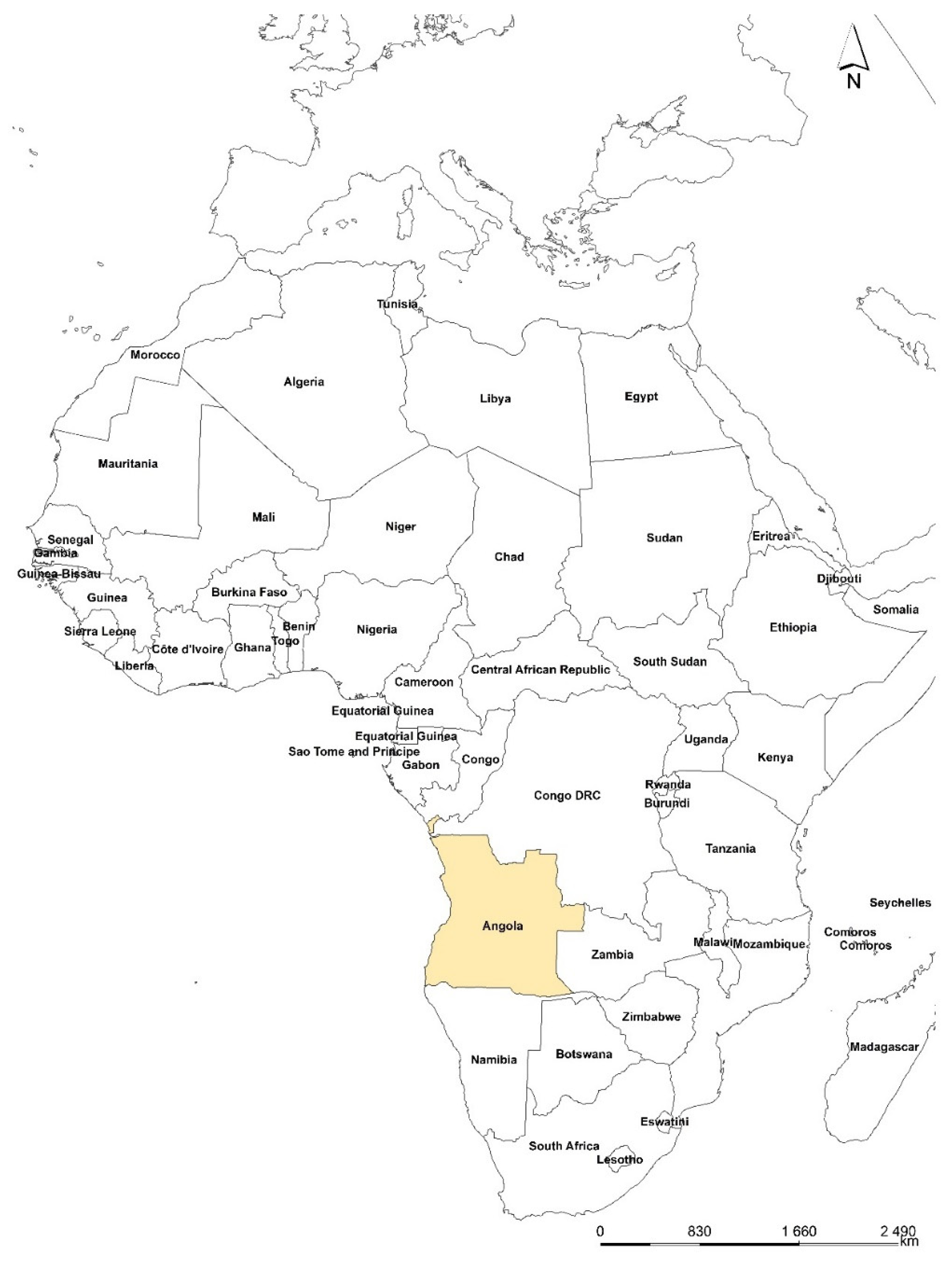
Luanda is the capital of the Republic of Angola (
Figure 3), a vast country situated in tropical west-central Africa. The Luanda Metropolitan area comprises 5.261 km
2, where, according to the 2014 census, over 6.9 million people reside [
56]. The estimated number of population is projected to increase to 12.9 million by 2030. The United Nations estimates that Angola, in the coming years, will experience one of the 10 highest population growth rates in the world [
57]. Projections also forecast that a predominantly young and active population will be concentrated in vast urban areas such as Luanda.
Luanda Province encompasses the municipalities of Luanda, Cazenga, Belas, Cacuaco, Viana, Icolo e Bengo and Quiçama. However, this work does not include the Quiçama municipality for reasons related to data acquisition and availability. Approximately 67% of the metropolitan area is naturalised land, and 16% is agricultural area. Urban settlements occupy the remainder, almost half of which (49%) are informal settlements locally known as
musseques, many of them located in flood-prone areas. About 80% of Luanda’s population lives in these informal
musseques [
14].
The flow of rural migrants as a consequence of a 27-year civil war and the collapse of the economic system led to a massive expansion of the
musseques in the metropolitan area. After the ceasefire was signed in 2002, the urban growth rate remained high. In a context of high poverty and precarious situations, the search for better living conditions became the leading cause of this growth. Thus, presently, the Luanda metropolitan area has one of the largest and densest urban centres of southern Africa, where one-third of the total Angolan population lives [
56].
The climate in the region is tropical xeric, characterised by two seasons, a hot, rainy season (from October to May) and a dry, cold season named cacimbo (from June to September). The mean annual temperature is 24 °C and yearly rainfall is 325 mm.
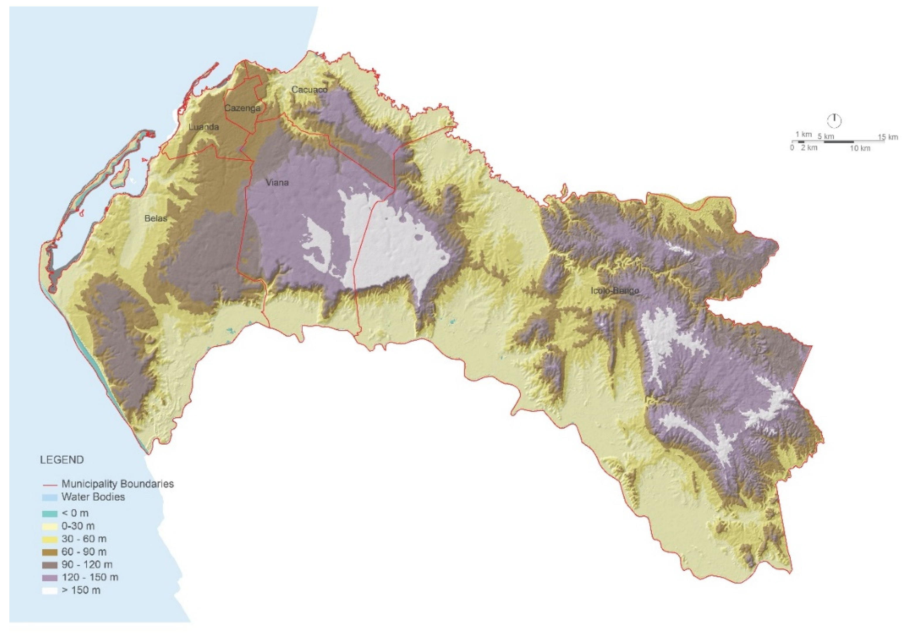
The morphology of the Luanda metropolitan area is complex regarding altitude, slope, and aspect orientation, resulting in different local environmental conditions. Vast plateaus occupy the centre and southeast, and lower altitude areas are localised on the coast and along the Kwanza River. Much of the study area, about 25%, is under 30 m altitude. Only about 6% is higher than 150 m. The majority of the territory, about 71%, is characterised by gentle slopes (0%–5%). Only a small area (about 2%) has slope values higher than 15%. The steeper areas are located on the southern edge of the western plateau area and the west side of the south-eastern plateau (
Figure 4).
Two river basins dominate the Luanda metropolitan area. The Kwanza and Bengo Rivers are characterised by a complex hydrological network. Throughout the study area, intermittent watercourses have cut through soft lithology, generating clear signs of water erosion.
The metropolitan area, from a geological and geotechnical point of view, presents a high risk of rupture and collapse and consists of the following soil types:
Alluvial (mainly those soils dependent on the Bengo River to the north and Kwanza to the south) and coastal deposits (Ilha, Baía, Porto and Restinga de Luanda), unsuitable soils for foundations due to their charge capacity, the rise of water-table level, and erosion risk;
Clay and expansive soils and those with poor drainage, especially the Cazenga formation, but also the Luanda-Cacuaco formation;
Collapsible and highly erodible soils of the Quelo formation (throughout all the metropolitan areas).
Regarding vegetation, most of the study area would have been covered by a complex mosaic of Miombo woodlands and savannas with varying degrees of tree cover. However, due to human activities, vegetation is now profoundly altered and at various stages of degradation. The original vegetation communities have disappeared as a result of the agricultural occupation. The classification of the vegetation in the province is under seven broad classes: woodlands, open mosaic woodland–savanna, open woodlands with baobabs (Adansonia digitata), shrublands, dune communities, mangroves, and herbaceous wetland vegetation.
In the last three decades, urban expansion in the Luanda metropolitan area has mainly occurred at the expense of agricultural land and natural vegetation. This loss of green area has caused fragmentation and impoverishment of ecosystems with numerous impacts on the services they can provide, such as biodiversity, aquifer recharge, carbon sequestration, and soil nutrient enrichment. Also, many of the musseques have occupied environmentally unsuitable, high-risk (flood and soil erosion) and low-cost land such as river banks.
4. Developing Green Infrastructure for the Luanda Metropolitan Area
4.1. Data Collection and Preparation
In general, Luanda, Angola, similar to many African countries, suffers from a chronic lack of baseline information due to the social instability in the last decades after colonial departure and the beginning of civil strife. The available data are from the period before the country’s independence, at a time of Portuguese occupation.
In the absence of a comprehensive mapping of the study area, a combination of free satellite imagery and open-source data using GIS and CAD software platforms was used to create a suitable database for the area. In the initial step, the time the team had to make the first technical proposal and the money resources available did not allow us to find other remote sensing datasets available globally. This situation created a constraint on the team, who could spatially analyse the data only after creating a location map with GIS support.
Table 1 presents a list of the analysed information that was used, its scale, and source.
The interpretation and classification of satellite imagery to create a land-use base map were used to identify the locations of the main ecological corridors (rivers or other linear features) within the metropolitan area, as well as the sites of other valuable green assets such as parks, savannas, mangrove areas, or significant vacant lands. Satellite imagery also allowed us to define the extent of the urban area and the existing natural surrounding areas.
However, the spatial scale of the available satellite images did not allow the identification of smaller-scale green components, such as open spaces within the urban areas, urban agriculture plots, or tree-lined streets. Nevertheless, these green areas, although not easy to be spatially quantified, are of utmost importance for the resilience of the urban areas as they provide a range of essential ecosystem services [
58].
Based on the treatment and design of the database, it was possible in the next phase to delimit the areas for green corridors and those with higher ecological sensitivity. On-the-spot inspections accompanied the selection and determination of limits in all areas with more significant doubt, given the primary elements of work where scales and rigour were not always the most desired.
4.2. Identification of Existing Protected Areas
The current protected areas are framed within the National Strategy and Action Plan for Biodiversity, which promotes the compatibility between economic activities and the environment, ensuring sustainable use of resources, conservation of sensitive areas and ecosystem services. Two additional sets of legislation: Decree No. 43 of 77, May 5th, which outlines the types of conservation areas in Angola (National Park, Integral Nature Reserve, Partial Reserve, Special Reserve and Regional and Nature Parks), and the Law on Biological Aquatic Resources, which defines the need to establish aquatic protection areas based on social and ecological criteria, give support to the protection of the areas. These laws also establish the typologies of protected marine areas: Aquatic Nature Park, Aquatic Nature Integral Reserve, Partial Reserve, and Natural Monuments.
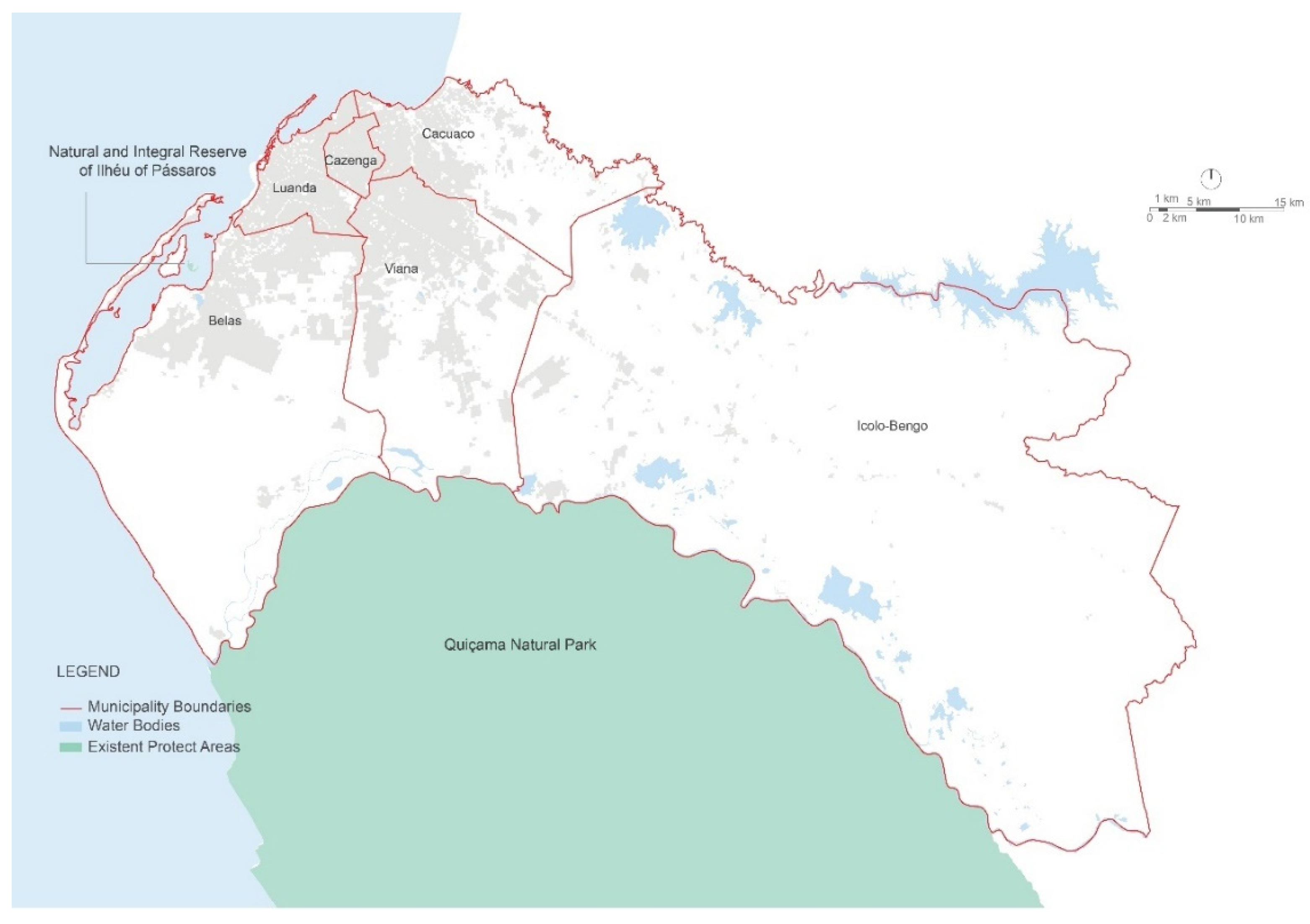
The two existing protected areas in the Luanda metropolitan area and their surroundings are present
Figure 5. The Natural and Integral Reserve of Ilhéu of Pássaros (42 ha) was created by Provincial Decree N° 55/73, of December 21st, to safeguard the existing avifauna and mangrove system in the islet. This small island is situated off the coast of Luanda, in the Mussulo lagoon, and is colonised mainly by mangroves, salt marshes, and intertidal mudflats. Quiçama National Park (996,000 ha) was created primarily as a Hunting Reserve in 1938 and was subsequently classified as a National Park in 1957 by the Decree N° 55 of December 21st of 1957. This park, located in Luanda Province, 75 km southeast of Luanda city, between the Atlantic Ocean, the Kwanza River, and the Longa River Park, possesses a great diversity of habitats. Along the estuaries, we can find mangroves, and several species of turtles that make their nests on the ocean beaches. These two protected areas are inscribed in law and are therefore part of the various existing legal constraints in the Luanda Province.
4.3. Natural Values
For the preservation of the biodiversity of the Luanda Province and Metropole, it is essential to develop not only a coherent network of protected areas but also supporting programs for the conservation and management of species and habitats outside those areas. As the baseline information for these areas is lacking, it is crucial to outline the spatial limits and also some of the future actions that focus on the evaluation and conservation of species and habitats, of scenic landscapes and crucial geological, geomorphological, and paleontological elements in the territory.
A rapidly changing environment in the Luanda metropolitan area shows that planning should not only consider and develop appropriate measures for the legally protected areas but also for the natural areas surrounding them, which play a crucial roles as ecological corridors connecting the core areas of conservation. Numerous studies confirm that one of the main threats to ecosystems is the fragmentation process that turns them into environmental islands. If left isolated, the protected areas, due to climate change, may suffer a loss of numerous species and, consequently, reduction of biodiversity [
23,
83]. So it is vital to develop detailed studies on the distribution, ecology, and conservation of important species and habitats.
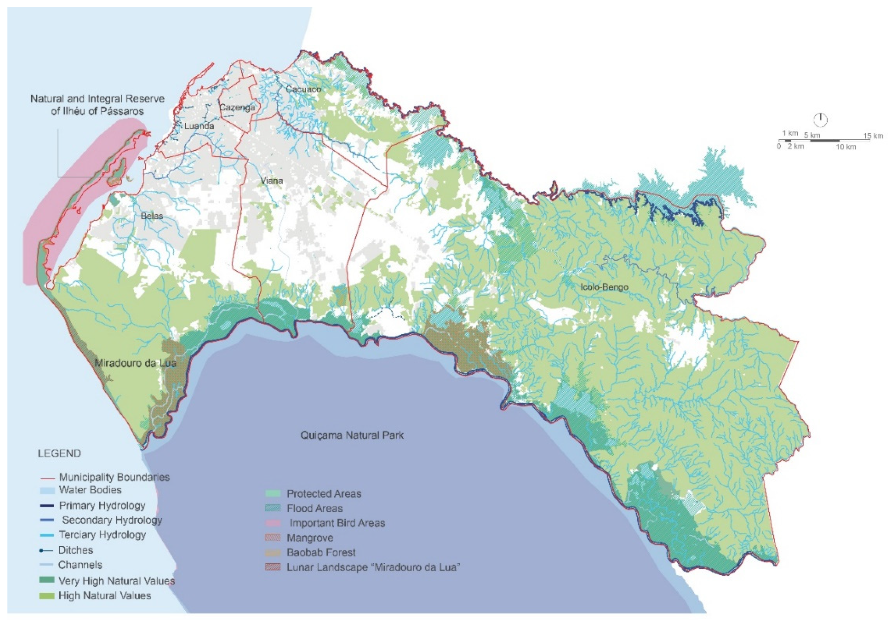
Landscapes and natural values identified (
Figure 6) are areas of exceptional landscape quality, geological uniqueness, or ecological importance, which help to maintain biodiversity, contribute to nature conservation and risk mitigation. Species and landscapes present in these areas also play a significant role in preserving the local heritage and identity. Consequently, in the primary green infrastructure we made the inclusion of all other areas, among such other systems as the Mussulo Peninsula, its dune vegetation, and the mangroves in the southern coastal area (Saco de Flamingos), mangroves around Futungo, the mangroves in the Kwanza flood area and Bengo River mouth, the Baobab forest in Viana, the coastline from the Kwanza River mouth to the southern tip of Mussulo and a critical geological area known as a
lunar landscape. They also include one Important Bird Area (IBA) in Luanda metropolitan area covering 17 ha in Mussulo Peninsula. Another IBA occurs in the surroundings in Quiçama National Park.
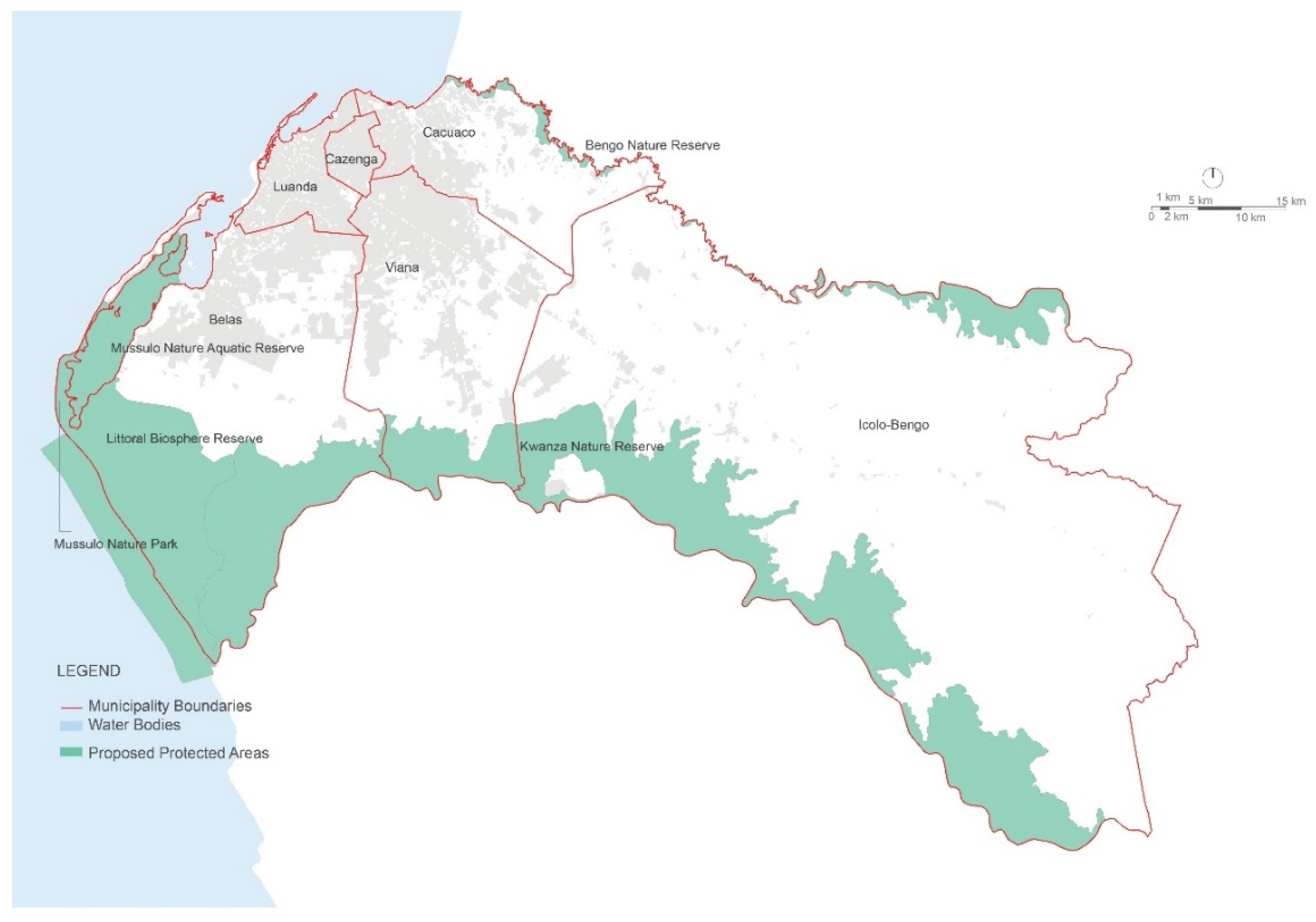
The proposal of five protected areas (
Figure 7) takes into account the existing natural values with the aim of the ecosystem and species preservation and protection of high-value landscapes. These five protected areas are described below and integrated within the primary green infrastructure.
4.3.1. Littoral Biosphere Reserve
The creation of the Littoral Biosphere Reserve accomplishes three main goals: (1) ecosystem and species conservation; (2) protection of the landscape; and (3) promotion of socially and culturally sustainable development and establishment of a research, education, and monitoring platform. This reserve, located within the Belas Municipality, stretches from the mouth of the Kwanza River to the southern tip of the Mussulo Peninsula with over 36,845 ha, and it features some of the most exceptional landscapes in the Luanda metropolitan area. The spectacular lunar landscape, with outstanding scenic value, can act as a trigger for tourism-related activities developed on a sustainable basis. Other characteristic elements of this reserve area include the beaches, which constitute an important resting area for many bird species, like the American Flamingo, and turtle species such as the Olive Ridley turtle, some of which have protected status and require specific policies to ensure they continue to thrive.
4.3.2. Bengo and Kwanza Nature Reserves
Bengo and Kwanza River corridors are both low-lying, alluvial areas, prone to periodic flooding. The boundaries of the proposed nature reserves follow the natural courses of these rivers and include the stretch of land within the historic flood lines. Respectively with 9690 ha and 8367 ha, they contain significant landscapes of high environmental value, such as the mangroves, the baobab forest, especially in the Viana Municipality, and the more extensive marshlands and meadows. These areas need protection to ensure not only the conservation of sensitive ecological habitats but also to provide sustainable human activities such as agriculture or rural tourism.
4.3.3. Mussulo Nature Park
Due to the specific sensitivity of the Mussulo Peninsula to coastal erosion and sedimentation, the presence of natural systems such as mangroves or coastal dune vegetation confers particular importance. This proposed protected area not only plays a vital role as a nesting and feeding ground for a large number of species, but also increases the natural resilience of this highly valuable landscape. From the southern tip of Mussulo to the middle of the peninsula a total of 2275 ha are assigned for protection; given its location close to the Luanda urban centre and the already existing tourism and lively second-home market activities, policies for this area must ensure its overall sustainability (taking into account its carrying capacity), while allowing the current economic activities.
4.3.4. Mussulo Nature Aquatic Reserve
The Mussulo Nature Aquatic Reserve aims to protect the threatened marine feeding, nesting, and development areas of many endangered birds while guaranteeing that local fishing communities can continue their traditional activities without jeopardising natural resources and biodiversity. This proposed area (around 8300 ha) stretches from the Saco dos Flamingos site, on the southern tip of the Mussulo Peninsula, to the Ilhéu dos Pássaros Integral and Nature Reserve.
4.4. Rivers
The Metropolitan area has a complex hydrographic network, mainly towards the interior of the territory, in the municipality of Icolo and Bengo (
Figure 8). There are two main rivers: the Bengo and Kwanza Rivers, which form large and very complex ecological corridors, temporally and spatially dynamic, playing a critical role regarding the interface between terrestrial and aquatic ecosystems. Across the study area, there are numerous intermittent watercourses, quite visible even on aerial photographs, many with obvious signs of water erosion on their margins as a result of the degradation of urban development with consequences such as floods and landslide.
At the northern limit of the Luanda metropolitan area is the Bengo River in the zone of the Quiminha dam. It rises on the Plateau of Camabatela, in the Province of Kwanza Norte. It has an extension of 350 km and flows into the Cacuaco zone, and has a hydrographic basin of 13,160 km
2 [
68,
69]. Along this river there are several lagoons. The Kwanza River rises in Mumbué, in the Province of Bié and flows into the Atlantic Ocean at Barra do Kwanza, about 70 km south of Luanda city. This river has an extension of about 1301 km, being the largest river that rises and drains in Angola. It comprises a river basin with an area of 152,570 km
2 [
69]. The Kwanza basin is characterised by high diversity regarding fauna and flora, particularly in the coastal zone. Along the Kwanza River, there are several lagoons and artificial channels.
The high productivity of these river corridors is responsible for extreme pressures on them, creating severe ecological and economic imbalances. Stream corridors are essential habitats for wildlife, necessary for the natural drainage system, for water supply, for agriculture practices, as an aesthetic amenity in urban or rural settlement areas, and as a resource for open space and recreation. The different pressures that bear on this natural resource demand that a comprehensive management scheme for the entire system needs to be defined and implemented.
Inside the city of Luanda proper, the Cambamba River stands out, which flows into the Mussulo bay and constitutes an important ecological corridor. Along its banks small plots with urban agriculture are found. However, in the river mouth, the banks are reinforced by a concrete channel. The Cambamba River, together with its tributaries, Vala do Senado da Câmara and Vala Cazenga Cariango, promote surface drainage of several densely populated neighbourhoods in the city of Luanda. These areas, exposed to flooding during high-intensity rainfall events occurring in short periods, are a consequence of the overflow, which causes flooding in the adjacent areas and thus extensive material damage and loss of life.
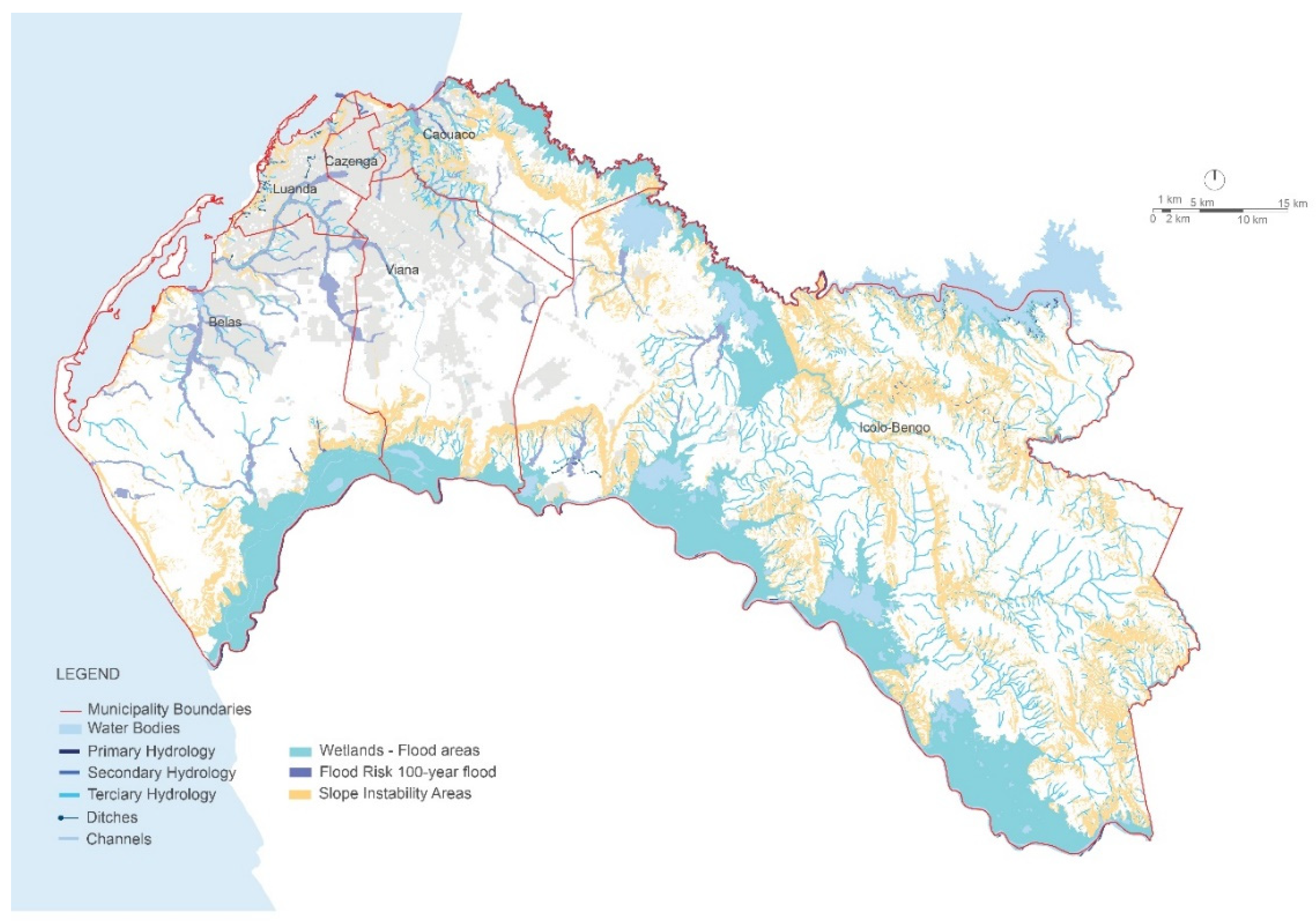
4.5. Risk Areas
The Luanda metropolitan area, due to its geographical location, climate, land occupation, and other factors, is particularly susceptible to several typologies of natural hazards, such as flooding, landslide, and sea-level rise.
Figure 8 presents the risk-prone areas included in the green infrastructure where the re-naturalization of these areas can work in articulating the grid of green corridors.
Future municipalities can adopt the identification of these areas, which is grounded in existing information on the regional scale concerning the detailed risk assessment relating to steep slopes and land subject to sinking or slippage, before allowing any urban development plan in their jurisdiction.
Several areas in the Luanda metropolitan area—in particular, the musseques—are very vulnerable to slope failure. Slope failure involves the movement of rocks, soil, or debris under the action of gravity and can result from two different types of factors: conditioning factors and initiating factors. The conditioning factors involve slope gradient, geology, climate, and land cover. The initiating factors are heavy rainfall, flooding, human activities, and earthquakes.
There are several methods to determine the vulnerability of the territory to erosion risk. This research used the multi-criterion assessment, which allowed us to order and hierarchise data from different sources, based on an assessment expressed in values and scores, according to the intensity or degree of importance and the various criteria.
A limited number of variables (slope, lithology, and land use) were considered sufficient and representative, but more variables can be integrated to assess the risk and vulnerability; however the previously mentioned lack of data made it impossible. These variables were then taken into account to obtain a synthesis that represents the different areas according to the susceptibility to erosion.
The Luanda metropolitan area presents a high variability of rainfall and an increase in heavy precipitation in the last decade [
56]. These meteorological events have implications for watersheds, such as increasing soil erosion, changing the sedimentation pattern, and increasing the probability of extreme hazardous events such as floods.
On the other hand, the incidence of heavy rainfall and flooding can increase the risk of disease outbreaks such as cholera and gastrointestinal diseases, linked to the existing poor sanitation and lack of potable water. The public health risk rises with the presence of temporary ponds in urban areas during the rainy season, which in Luanda are prevalent due to the existence of many small depressions and relatively impermeable soils. According to Presidential Decree No. 103/11, May 23rd, during the period from 2002 to 2007, several floods were registered in the Luanda metropolitan area as a result of heavy rainfall that produced an increase of river flow. These floods caused the loss of lives, the displacement of families, and damage to buildings and agricultural fields.
The identification of flood-prone areas resulted from a rigorous analysis of the existing situation through the elaboration of hydrological models capable of calculating the floodable areas with a period of return of 100 years. Due to the lack of necessary data, the cartography was elaborated through the analysis of historical occurrences based on bibliographical research; of geomorphological, geological, and hydrological criteria; and through contact with the population.
The main risk areas occur within the urban environment where extreme events can have catastrophic consequences. They include the steep slope areas between the Luanda plateau and the Atlantic coastline and the flood zones of the Rivers Kwanza and Bengo, Mulenvos and Cambamba. These risk areas are within the primary green infrastructure. They need to be protected and managed adequately due to their ecological importance and the dangers that they may cause to populations.
Likewise, soil and hydrological conditions in risk areas interact with other earth systems in response to human activity. These risks may sometimes be unavoidable [
84].
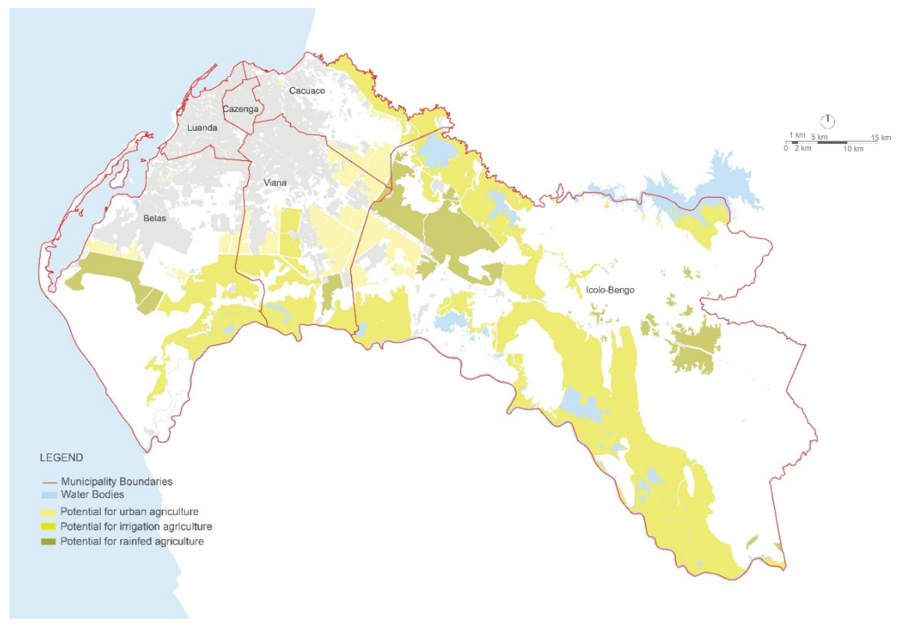
4.6. Agriculture
The areas suitable for agriculture were identified based both on the intrinsic characteristics of the soils and on water availability. When these two variables are favourable, they combine to define high productivity (
Figure 9). These areas include urban agriculture on the one hand, and, on the other hand, areas outside the urban limits, where both irrigation and rainfed agriculture can occur.
The Bengo and Kwanza rivers, as well as areas close to wetlands, maintain potential for irrigation practices because of their fertile alluvial soils and proximity to water. In the Bengo and Kwanza alluvial areas, in particular, constraints to agriculture exist related to periodic flooding during some months of the year. The other areas, where irrigation is not feasible, are considered suitable for rainfed agriculture.
Alluvial soils are essential, in particular near the coastline, because mangroves occur in this soil type. These are extremely productive ecosystems that provide habitats for several terrestrial and marine species, and they also play an essential role in the protection of the coast from erosion. The soils of mangrove areas, nevertheless, are not suitable for agriculture, due to the high salt content.
An area of agricultural interest stands out in the perimeter of Kikuxi, located in the Viana municipality, which extends into the banks of the River Kwanza. This area is managed by the Gabinete de Desenvolvimento e Aproveitamento Hidraúlico do Kikuxi, which ensures the development of agricultural and livestock activities and divides this region into two broad areas of agricultural and livestock operations, characteried as irrigated and non-irrigated areas. The Presidential Decree No. 37/11 of March 4th created the Kikuxi Agricultural and Agro-Industrial Zone, with an area of 15,627.93 ha, that establishes, in two phases, the classification and conversion of the Kikuxi perimeter, which has an area for agrarian, forestry, environmental, and agro-tourism development and yet another for urban and agro-industrial expansion.
In the urban areas of Luanda, vacant plots, which are part of the complementary green infrastructure, can be used for environmental and cultural purposes, including urban agriculture. These areas help to protect biodiversity, provide stormwater control, allow the production of fresh food products for local consumption, and facilitate the development of cultural and educational activities to reconnect some of the population with nature.
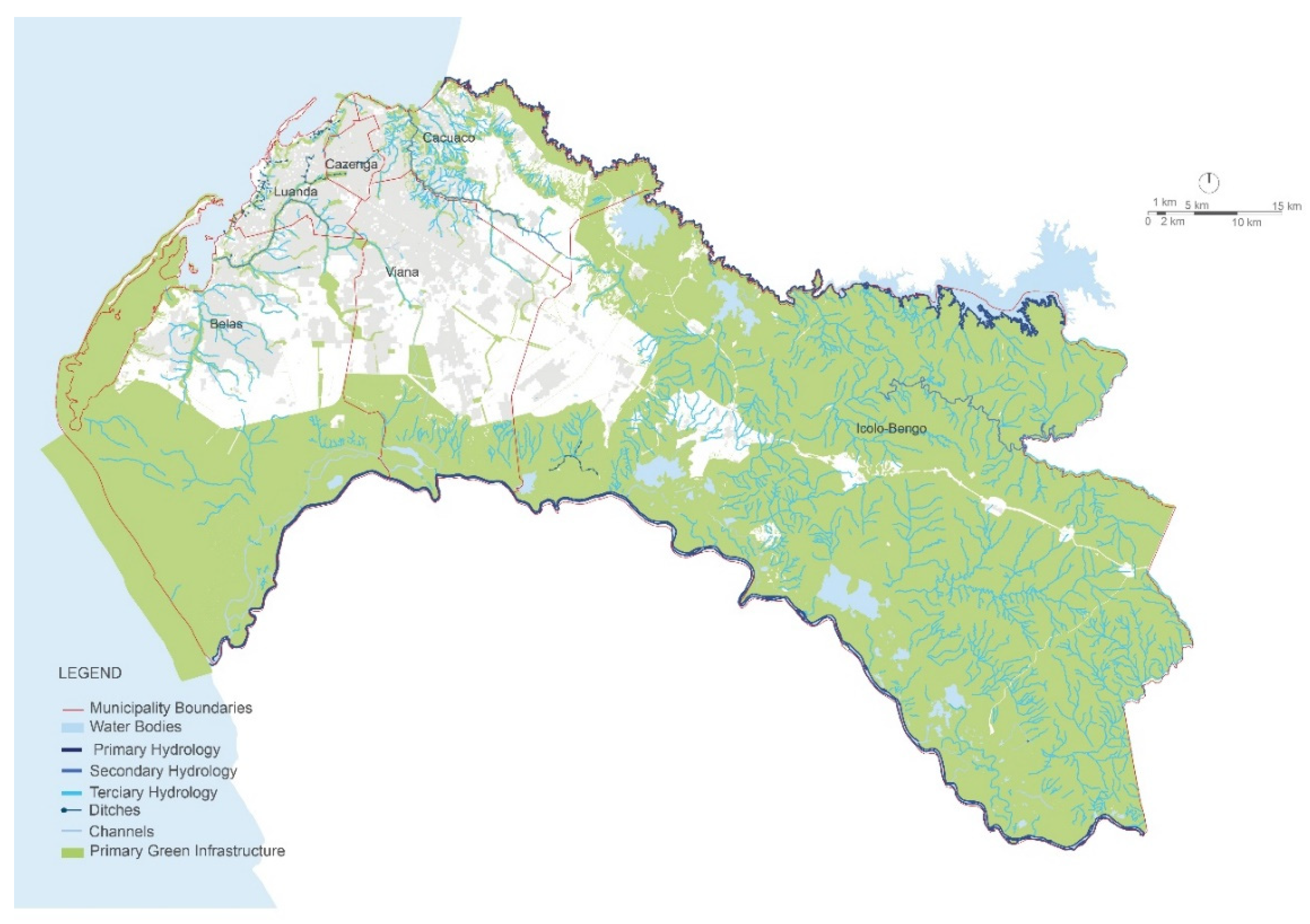
4.7. Green Infrastructure
The proposed primary green infrastructure, composed of all the factors listed in the above chapter, is presented. The conception of a green infrastructure for Luanda Metropolitan area is a considerable challenge, since it needs to support planning actions but also work as a civil protection activity through the definition of preservation areas of vital functions. This network creates connections between various regional and national systems, ensuring the continuous ecological processes, and includes (
Figure 10)
Main rivers: Kwanza, Bengo, Mulenvos, and Cambamba;
Watercourses of torrential nature, including the tributaries of the central river systems;
The existing protected areas: Nature and Integral Reserve of the Ilhéu dos Pássaros, Quiçama National Park;
The proposed protected areas of the Littoral Biosphere Reserve, the Kwanza, and Bengo Nature Reserves, the Mussulo Nature Aquatic Reserve and the Mussulo Regional Nature Park;
Areas of high natural value including the baobab forests, sensitive coastal vegetation (particularly in Mussulo), mangrove areas around Kwanza and Bengo River and Mussulo, and other essential habitats presents;
Areas structurally crucial due to their natural qualities and values, such as those adjacent to protected areas that include open and savannah mosaic forests;
Areas subject to flooding and slope failure, which include the steep slope areas of the Luanda plateau (in particular, the slope along the Atlantic coast) and the areas subject to flooding along the major rivers of the province;
Existing and potential agricultural areas both in the rural and urban settings, including those surrounding the urban area.
The Luanda Metropolitan green infrastructure comprises 78% of the territory: 309,139 ha of hubs and 105,340 ha of corridors, totalling 414,479 ha that include the open water area in these calculations.
Overall, the proposed green infrastructure contains most of the metropolitan area’s biodiversity, natural resources, and risk zones (
Table 2).
It should be highlighted that issues such as economic and financial analysis were not considered, given the state of socioeconomic development in Angola and the difficulty, as mentioned earlier, of access and permission to use the information. The nonexistence of a planning process that acknowleges the fragile conditions of areas with ecological value in order to regulate and limit their occupation always results, in these regions of the globe, in a painful repression of the living conditions of the populations.
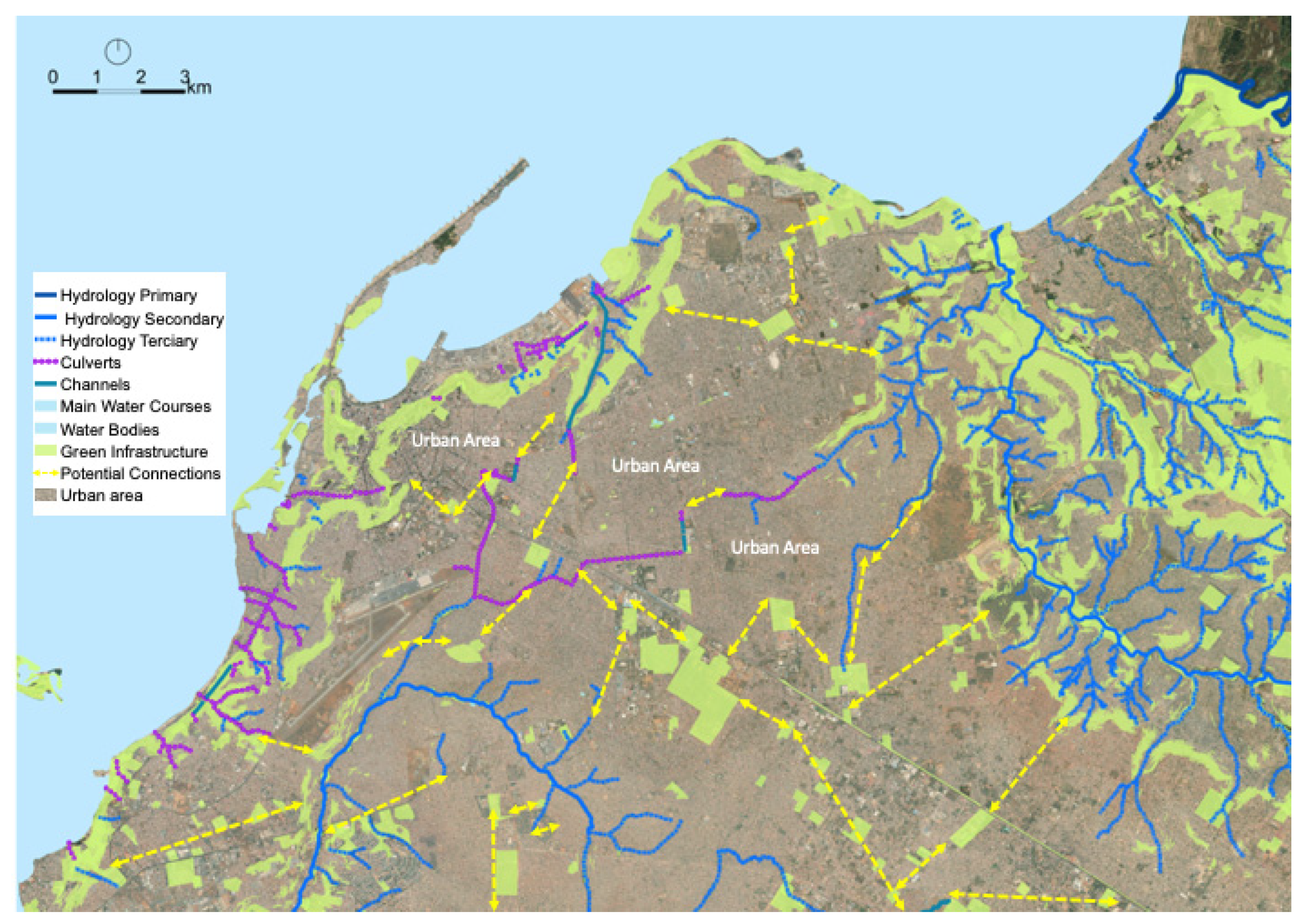
Detailed information and on-the-spot inspections allowed us in some areas to have a more comprehensive framework GI (
Figure 11) that will identify at the urban level what is needed to gain deeper information and provide a basis to develop other levels of the GI.
5. Discussion
5.1. Methodological Aspects
The lack of access to proper resources and of local capacities and skills to begin data analysis is one of the of considerable challenges to the near future that the presented method addressed. It was a challenge to have frequent updates of data, which were required to keep up with the changes in the territory. Beyond the lack of information data, significant problems detected in similar cases were the lack of local capacity and expertise, the lack of local knowledge of socio-cultural values, the lack of management and coordination at different scales.
The Geographic Information System was an essential tool because it could support a methodological framing as well as integrate all sorts of data. Developing countries presented a problem in the availability of appropriate and up-to-date data that was on the right scale to act.
The delimitation of green infrastructures can include different intervention scales: municipal, regional, metropolitan area, and local community [
34,
58,
85,
86]. In this research, a comprehensive green infrastructure for the Luanda metropolitan area was developed where the missing data and weak policies required new approaches and initiatives to produce guidelines for planning actions within the area, similar to the work of [
59,
60].
Limitations of the baseline data maps for the Luanda Metropolitan green infrastructure were particularly meaningful at the 1:75,000 scale or lower, affecting the input and output possibilities of this research [
87]. A comprehensive mapping survey and studies to add the necessary elements and to develop and detail the green infrastructure were therefore required to enrich the structure at the lower scales, and, thus, most of the metropolitan territory would have a strategy resulting from its inclusion. That was very important because near the metropolitan area there are many vital areas that, from an ecological point of view, provide vital ecosystem services and contribute to the sustainable development of the region.
The primary strategy for these areas consisted of maintaining permanent nature-based uses such as agriculture, woodland, rangeland, and others of the same type, as well as spaces that offer opportunities for recreation and leisure, allowing the population to benefit from and enjoy these areas [
87,
88]. These uses also contribute to the mitigation of flood risks, promotion of biodiversity, improvement of air and water quality, and amelioration of the quality of life of nearby local populations.
The green infrastructure, as it is an ecosystem-based approach, also enhances the synergies among the social and ecological benefits, which increase the resilience of the territory. The proposed green infrastructure is multi-dimensional/multifunctional because it addresses many parameters/challenges that help urban areas to respond more flexibly to environmental changes and also to the transformation for the support of human activities.
5.2. Results and Implications
The time for planners and decision-makers to effectively plan a green infrastructure is considered a part of the essential role that is played in sustainable development as it applies to regional planning. The Luanda region presents an enormous population pressure, a high level of poverty, chaotic urban development with vast extensions of informal settlements; still, it is also a region with great opportunities. The lack of steady enforcement of plans, policies, and regulations in these countries has had the consequence of land and ecosystems degradation.
The low-income settlements tend to be located in hazardous areas, exposing the resident population to a collection of disservices. Problems like poor sanitation, open wastewater drainage, and unsafe garbage disposal, combined with land depressions and poorly drained lands, can spread diseases like diarrhoea and malaria amongst these settlements. The added increasing climate variability, including higher temperatures and changed rainfall patterns, is expected to worsen these problems further. In low-income and informal settlements, in different African countries, there is a a strong dependence of local communities on regulating and provisioning ecosystem services, as it happens in the Luanda Metropolitan region.
The green infrastructure should be viewed not as a limitation to urban growth and infrastructure development, but instead as a nature-based solution for solving existing problems. It is an essential connection between urban areas and their surrounding environments, improving the health and well-being of the population concerning the different dimensions of life: social, economic, and mental, physical and spiritual. There is an increasing consensus that the maintenance of biodiversity is an essential component for reducing extreme poverty [
84,
89]. It improves food security and therefore reduces social vulnerability [
42], which affects the level of public health [
36]. The green infrastructure incorporates rural and urban areas where agriculture should be practised in a sustainable way to contribute to climate change adaptation.
It is recommended that urban planning and policies should prioritise connected green corridors of regional or local critical importance rather than a multitude of fragmented green areas. Still, the total percentage of green space is the most impactful for climate resilience and, in practice, possibly the most useful at low costs [
8].
This GI has the potential to protect sensitive habitats from anthropic modifications and also helps to mitigate the effect of severe natural hazards such as flooding or slope failure, which happen so frequently in this region. The inclusion of the coastal areas is crucial regarding the response to the sea-level increase and extreme storms and rainfall events. It should also include important ecological habitats such as dune vegetation and mangrove areas, which are essential from an economic point of view, for example, for tourism and traditional practices of sustainable fishing.
The green infrastructure proposed in this research increases landscape connectivity over the different parts of the territory through the creation of a continuum of natural/semi-natural areas. This potential is critical to guaranteeing the dispersal and migration success of a wide range of species and the maintenance of the genetic variability of populations. The green infrastructure links two existing protected areas, now disjointed both spatially and legally. This infrastructure includes the water network, thus preserving ecological and social diversity along the rivers and promoting the functionality and the uniqueness of these spaces, as a part of the whole watershed.
The proposed green infrastructure also provides an opportunity to restore flood-prone areas that are currently degraded or occupied by informal settlements, contributing, in this way, to a nature-based solution for the sustainability of the metropolitan area. This multifunctional approach can help urban areas respond more flexibly to a changing set of environmental challenges, including climate change. The green infrastructure helps restore natural processes in the urban area by providing permeable surfaces that allow for rainwater infiltration, a critical challenge in this climate, thus promoting sustainable stormwater management. Good practices in land management encourage water filtration, produce more reliable downstream flow, and reduce the number of sediments and nutrients entering into water bodies that feed urban water supplies.
The complementary green infrastructure helps to restore local natural processes. For example, by providing permeable surfaces where rainwater is intercepted, stored, and infiltrated into the ground, and by moderating urban heat islands through evaporative cooling and shading. Moreover, this green infrastructure helps to connect all the urban areas to their natural surroundings through green corridors, urban agricultural areas, and open spaces. This complementary green infrastructure provides an opportunity to restore degraded areas in the urban context, and also allows identification of areas that support the functioning of biodiversity at the metropolitan scale. These areas embrace biodiversity within which it is possible to serve as ecological corridors.
5.3. Limitations and Potential Development
The method and process presented to ensure the natural value of the territory and to highlight green infrastructure major areas was a useful tool for the planning of urban areas in a growth context.
The Geographic Information System was a useful tool because it provided methodological framing as well as all sorts of data that was used. Of course, these countries have a problem in the availability of appropriate and up-to-date data, at the right scale. Limitations of the baseline data maps for the Luanda Metropolitan green infrastructure were particularly meaningful at the 1:75,000 scale or lower, affecting the input and output possibilities of this research. A comprehensive mapping survey and studies to add the necessary elements to develop and detail the green infrastructure, are therefore required to enrich the structure at the lower scales.
Nevertheless, the lack of data available in a format that allowed their use made it difficult to define areas correctly and to connect more quickly with other strategic planning or intervention procedures in the territory.
So, when compared with published works, the results show the need for a specific context based on different possible methods to be used for mapping and delimiting the GI. For example, see the approach developed by Hui et al. [
90], who studied a large number of cities in China and who went through a holistic reading of street vegetation at the level of the city system that could delimit a GI. The same is true when compared to the Ignatieva method; Stewart and Meurk [
28], Irena et al. [
28,
36], Douglas [
44], Benson [
62], Niedźwiecka-Filipiak [
91] and Pei [
92].
The proposed method is adapted to a reality on the African continent and the difficulty of obtaining data, and in its integration in the context of supporting a planning process, it presents advantages over previous models.
A culture of obtaining and systematizing sources and their correlation to different levels and scales of approach is one of the advantages of the method and results from the articulation made up of varied combinations and sources of different levels.
Some areas that deserve attention in future research:
There is room to improve the specifications of the current study (for example, development of a common scale that can be adapted to different studies and development plans of urban areas; an analysis in a modular grid) by covering an entire study area that includes more densely occupied areas and areas with environmental protection resources, in order to achieve homogeneity in a more holistic view of values and functions, which makes it possible to delimit and evaluate a GI between central areas;
Expand the perspective of the GI study to civil protection and public health, where diversity and consistency in the objective landscape can be integrated with support in the form of photos of residents’ contributions to better understand the feeling of functioning in the IG spaces;
A key point is multifunctionality, as Hansen [
93] states it must assess specific site-level as well as social and economic factors. This is also highlighted in the research of Grădinaru and other authors [
94], who link the evolution of urban landscape patterns and show the gap between objectives and outcomes due to incomplete integration of institutional and other specific local and regional dimensions. The social—cultural dimension is essential and could benefit the role of GI in building a sense of place and identity [
95]. The relationship between the green infrastructure and nature-based solutions, ecosystem services and welfare as evaluations of spatial planning outcome are areas that need further and future research in this Africa context.
6. Conclusions
This work discusses how the objectives of nature conservation and biodiversity can be implemented through the green infrastructure (GI) of a metropolitan area, integrating environmental protection and enhancement effectively into the new development proposals. The green infrastructure is a fundamental part of the planning model selected for this area and is crucial for its balanced and sustainable development.
The role of GI as a strategic planning approach is highlighted by the literature review, based on nature-based criteria, connectivity, multi-functionality, integration of green elements, and social inclusion. Social and cultural services must be part of the future detailed local scale delimiting the green infrastructure.
In this framework, a limited number of variables (slope, lithology, and land use) were considered sufficient and representative, however, more variables can be integrated to assess the risk and vulnerability. However, the previously mentioned lack of data made it impossible, and the functional approach allowed us to assure the essential base information.
Use of the logic of urban planning and policies allows for prioritizing connected green corridors of regional or local critical importance (e.g., restore flood-prone areas that are currently degraded) rather than a multitude of fragmented green areas. Together with reliability, information analysis is a crucial point that must be explicitly considered.
The proposed methodology allowed us to define and delimit green infrastructure hubs and corridors for the Luanda metropolitan area of Angola, using an approach on the regional scale, taking into account the fundamental ecosystem functions, the cultural, educational and recreational values, and the existing legal constraints in this territory.
There are not many studies or works on the theme of developing countries in Africa or elsewhere. This research contributes to highlighting the importance of creating an integrated framework for different information levels to assure a GI for the sustainability and resilience of metropolitan areas with high population densities. The drive of the case study, other than the definition of regional green infrastructure in the Luanda metropolitan areas, points out the importance of nature-based solutions in the mitigation of climate change-driven issues and overall developmental sustainability.
The results achieve the objectives and have been implemented into the Luanda General Master Plan (PDGL) since 2016 as the basis for creating a macrostructure for GI. The green infrastructure that protects mangrove areas, native flora, vegetated slopes, and rivers banks provides a buffering function for natural hazards, crucial for these regions. Maintaining and promoting urban agriculture can help water management systems. It can help to prevent life risks in the future, and improve the health and well-being of local communities. Further research on how to integrate cultural and social specific characteristics of Luanda (and other African cities) to assure that GI will also be a contribution to welfare is relevant.
It is crucial to promote adaptation and resilience in metropolitan regions in Africa, which has a massive problem with informal settlements, by using nature-based approaches; urban researches are embracing this now in the northern countries. Authorities should approach and plan green infrastructure for informal settlements as a targeted environmental improvement effort in these areas.
The innovative finding of this research is the method that allows integrating a large number of data in the framework using a rational approach. The macro green infrastructure projects assure the preservation of the natural environment and create a local level way to guarantee the implementation and integration of GI and ensure benefits for the population. The nonexistence of planning policies is a real issue that directs us to consider as further development a guideline list of actions and a handbook to direct local and regional authorities.

 ,
, 


