Article

Possibilities for the Development of Building Plots with an Unfavorable Structure in the Context of Spatial Justice: A Case Study of Poland

Faculty of Geodesy and Cartography, Warsaw University of Technology, 00-661 Warsaw, Poland
*
Author to whom correspondence should be addressed.
Sustainability 2020, 12(6), 2472; https://doi.org/10.3390/su12062472
Submission received: 24 January 2020 / Revised: 5 March 2020 / Accepted: 18 March 2020 / Published: 21 March 2020

Abstract

:
To balance interests among local communities and increase awareness of the need to protect the environment, landscape and spatial order, there is a need for active participation, cooperation and mutual learning of participants in the planning process, including urban planners, specialists from other disciplines (among others, ecologists, landscape architects and surveyors), local authorities and residents. This article presents the problems associated with housing development in suburban areas within the context of rules for sustainable development, and spatial and social justice. It presents an assessment of the spatial configuration of plots and the possibilities for development and management of these in the selected communes located in suburban area of Warsaw, the capital city of Poland. A methodology was developed for the preparation of planning documents in the commune, allowing the minimization of the problem of spatial injustice resulting from the flawed structure of registered plots.

1. Introduction

The main dispute over spatial planning typically concerns the consideration of the public interest in city development on the one hand, and, on the other hand, the reductions in financial returns for investors and the elimination of spatial conflicts. The authors of this article assume that social justice is a desirable objective. However, it is important to differentiate between social, spatial and environmental justice, and injustice. In simple terms, the objectives of public policy in relation to “justice” in city development should be the equitable division of benefits and mitigation of unfavorable effects.
Since the appearance of the “right to the city” notion, described by David Harvey in Rebel Cities [1] (based on the equitable use of a city within the scope of rules for sustainable development, democracy, equality and social justice), two alternative concepts have occurred in the literature on the subject: the idea of an “equitable city” by Susan Fainstein [2] and “spatial justice” by Edward Soja [3].
As justification for isolated technocratic decisions made by planning authorities began to be questioned in the 1960s, citizen participation in spatial planning became commonly accepted, and the concepts of deliberative democracy were imported into planning theory [2]. The authorities of many European countries increasingly declared the possibilities for residents to participate in policy programming and implementation in various respects, providing dedicated geoinformation tools as well as organizing workshops and information meetings. Nonetheless, it is still difficult to reach the expected levels of involvement, not only in respect of residents, but also authorities.
Such a broad and multi-faceted approach to spatial justice raises many interesting research issues. The authors of this article focus on the issue of spatial and social justice at the local level—analyzing housing development and the unfavorable spatial structure of registered land plots, based on selected Polish examples.
In the central, eastern and south-eastern parts of Poland, plots used for traditional agriculture had a rectangular shape, with the long side adjacent to the neighbor’s plot. At the edge or in the middle of the plot (strip of land) were farm (housing) buildings. The strongest influence on the contemporary differentiation of the plots patchwork and the plot geometry was exerted by the partitions of Poland during the nineteenth century [4]. This traditional arrangement has been preserved substantially until today (up to 51.8% of the research area). This is of great importance in changing the form of land use from agricultural to residential. In suburban areas, in Polish conditions, free-standing residential developments are preferred, which are introduced by the owners along existing roads.
Excessive investment costs related to the adaptation of plots to development are often a barrier to rational and sustainable land management. The barrier in this case usually constitutes the spatial structure of registered plots, understood as the ownership structure of plots and their arrangement/location in relation to existing roads, as well as their unfavorable shape geometry (being too narrow and too long). Based on the analysis of local plans from various suburban areas, and other research studies, it can be assumed that narrow plots, below 18–20 m in width, and excessively elongated are considered particularly difficult to develop. Furthermore, if the majority of plots in a given area have such geometry, difficulties appear in the development of technical (roads, water and sewer lines, and other utilities).
Applicable laws in Poland do not specify the parameters of the plot geometry in detail, but their analysis leads to the conclusion that, taking into account the possibility of developing the plot, the optimal elongation of plots should be in a ratio of about 1:2, with a maximum ratio of 1:4, since increasing the elongation increases the plot area. Additionally, the minimum area should not be below 600 m2. As for the minimum width of the plot front, it was noticed that it is usually set between 16–25 m. This results from the provisions of the legal acts, according to which the building on a construction plot should be located at a distance from the border of this plot: no less than 4 m in the case of a building with a wall with windows or doors towards this border, or 3 m in the case of a building with a wall without windows and the door towards this border. The location of the building is allowed at a distance of 1.5 m from the border or directly at the border, if the local plan provides for this possibility.
These technical reasons, and the spatial and social problems arising from them, prompted the authors to undertake research in this area
The objective of this article is to emphasize the importance of the spatial dimension of social processes within the context of forming and, most importantly, counteracting the unfavorable special configuration of registered plots on land allocated for housing development. The article also discusses the issues of the socio-spatial models of European cities, and the summary focuses on European discourse concerning spatial planning and territorial management in an attempt to identify possible remedial scenarios for the negative tendencies that occur.

2. Methods

2.1. Presentation of the Problems of Housing Development in the Context of the Rules for Sustainable Development and Social Justice

The article presents a review of scientific and grey literature related to assumptions about sustainable development, involving achieving social justice combined with spatial justice. Key issues relevant to the discussion focus will be highlighted.

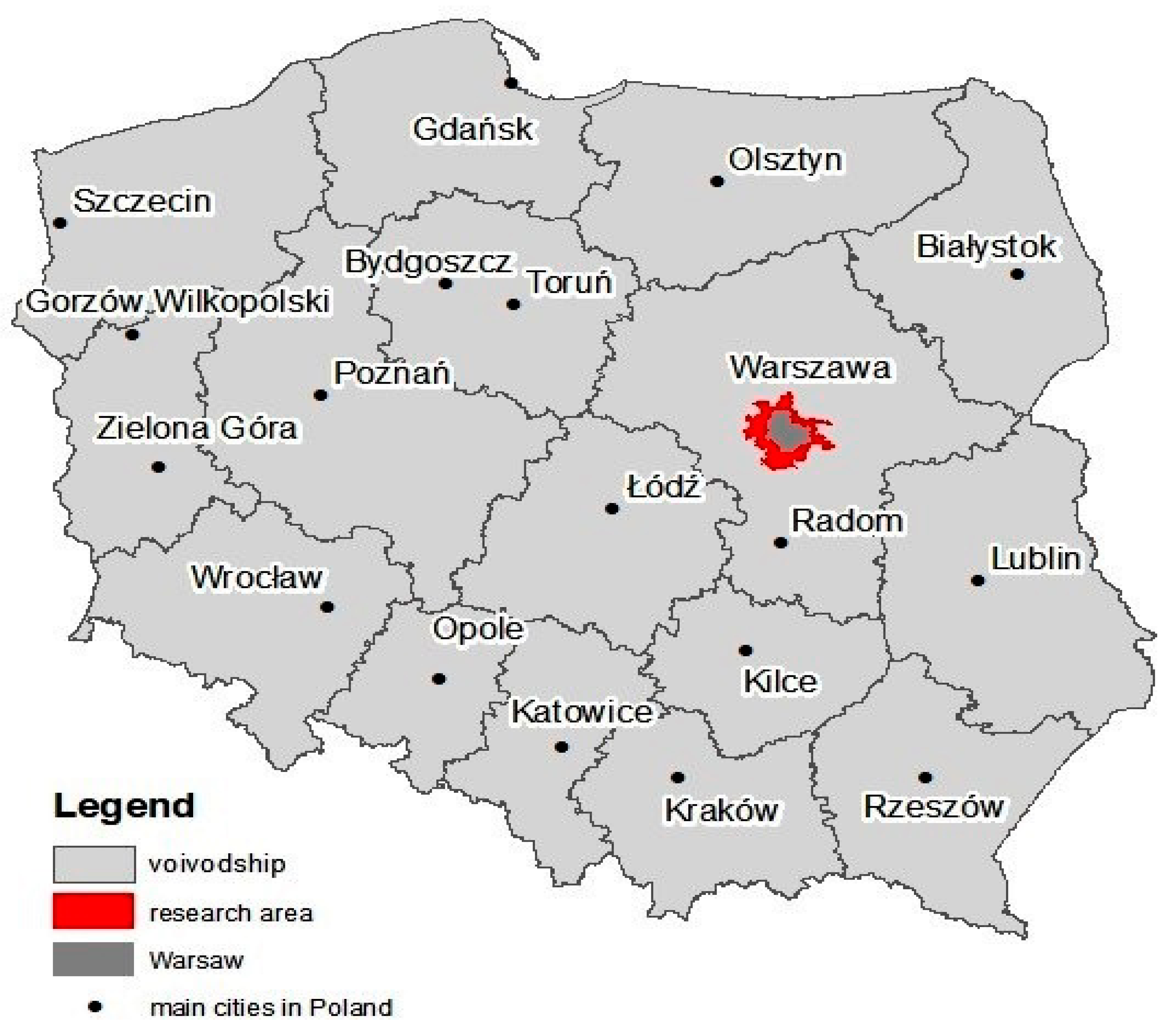
2.2. Assessment of the Spatial Structure of Plots and Possibilities for their Development (Case Study and Discussion)

Spatial planning in the context of achieving spatial justice can be evaluated in multiple contexts. The authors of this article have focused on the analysis of the spatial structure of registered plots, as this is one of the most important elements in Polish conditions.
The most important legal provisions governing the allocation of land for building development in Poland were discussed at the start of the study, considering the possibilities in relation to the application of procedures regulating the spatial structure of registered plots.
Following analysis of statistical data on building development, a study area was selected which best reflected the problem of urban sprawl at the cost of agricultural areas. The study area includes communes on the administrative boundaries of Warsaw, the largest city in Poland and the capital.
Based on data obtained from the Database of Topographic Objects, the land use structure of the study area was determined. Data obtained from the land and building register were then used to undertake quantitative research to determine the scale of the phenomenon. The spatial structure of registered plots was analyzed, including determination of surface area, length, width and elongation. ArcGIS ESRI software (13.0, Esri, Redlands, CA, USA) was used for the analyses.
Detailed case studies were performed based on cadastral data and an orthophotomap made available on the geoportal.gov.pl website, as well as local spatial development plans disclosed on commune websites. A detailed analysis was carried out of plans and drawings relating to local provision for spatial management, presenting proposed spatial solutions. Comparison of these with cadastral data facilitated the assessment of the possibilities for development of registered plots with an unfavorable shape.

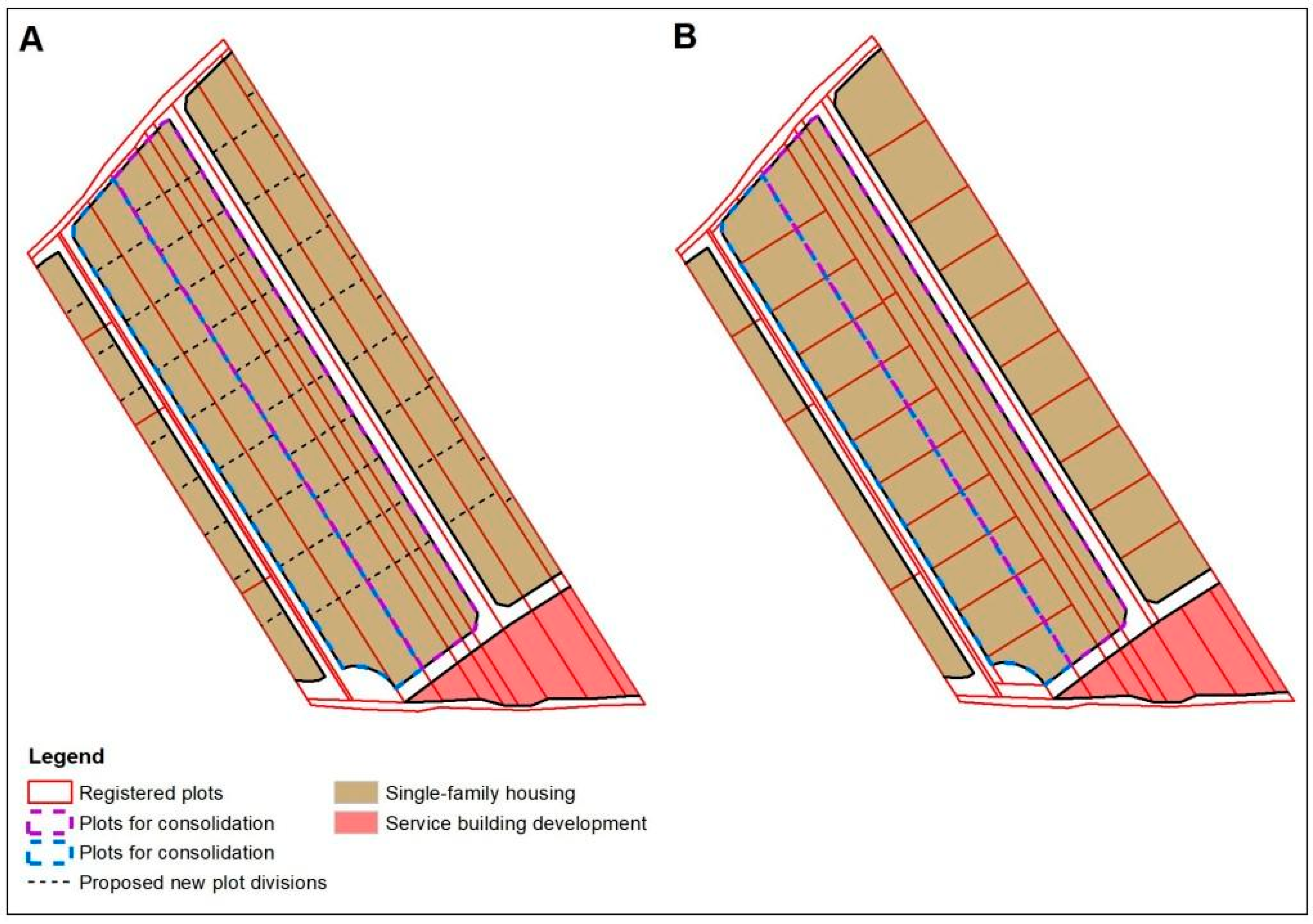
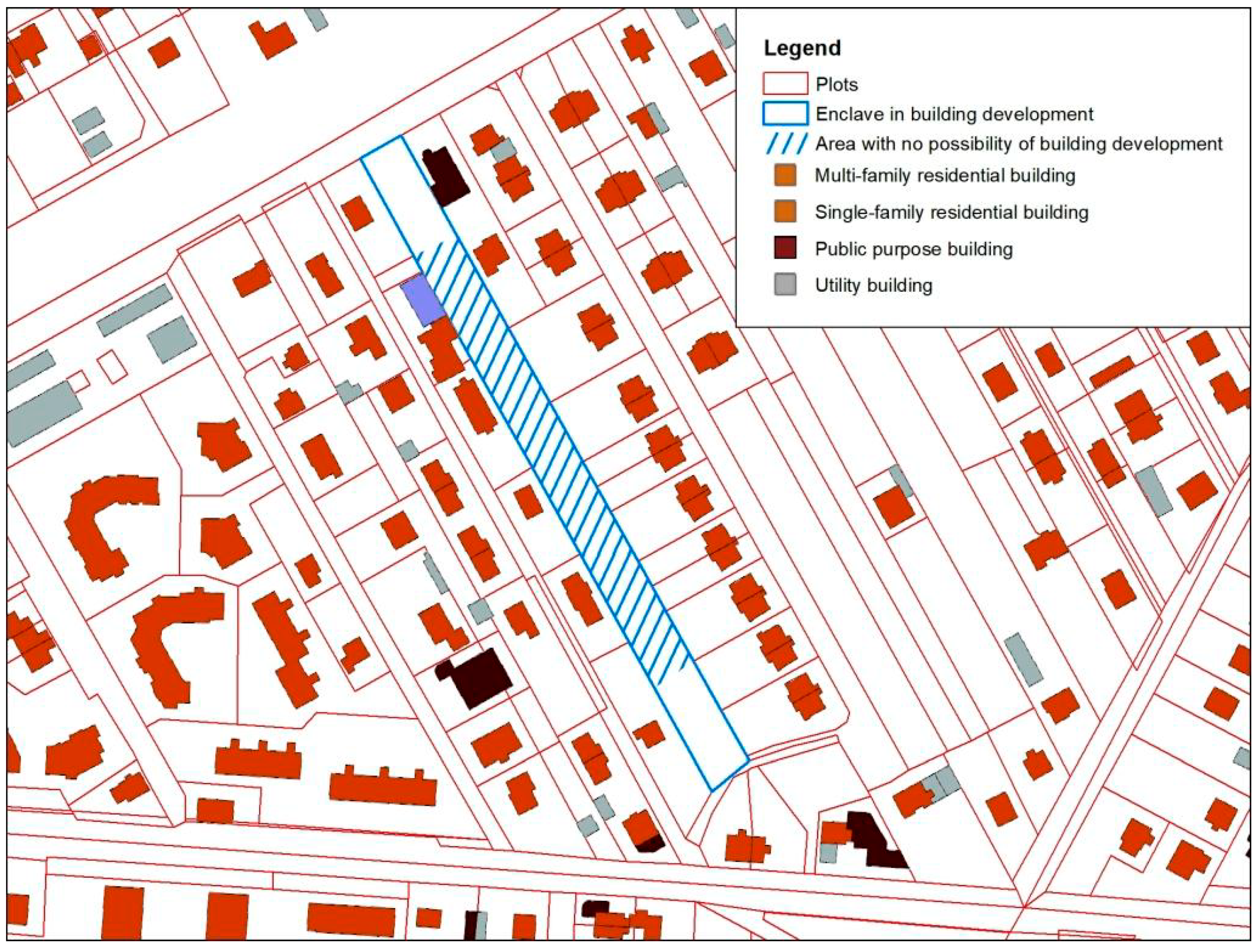
2.3. Proposals for Remedial Solutions

A methodology was developed for the preparation of planning documents in the commune, designed to minimize the problem of spatial injustice due to the lack of scope for the development of building plots in accordance with the provisions/arrangements of the local spatial development plan.

3. Literature Review

3.1. Sustainable Development

The development of society, technical possibilities and sociocultural transformations are continually changing factors determining the location of new housing as well as the function fulfilled by rural areas. The intensification of the transformation process in Central and Eastern Europe occurred during the period of political transformation after 1989, when the problem of uncontrolled building development in rural areas (i.e., suburban and exurban development) intensified with no consideration of the rules for sustainable development [4,5,6,7].
This is also extremely important for future generations, and the idea of sustainable development involves, among other things, global thinking through local action [8]. The concept of sustainable cities has been subject to discussion for more than two decades [9]. In the modern world, two concepts of development are in competition, namely socioeconomic, and responsible and permanent [10,11]. One of the forms of responsible development is smart development. This is currently binding in some areas of social life, for example, in the development of cities and the economy [12]. The first case concerns urban planning to provide city residents with the best possible conditions for recreation, transport, logistics, administrative and service facilities, and health facilities etc. The second case concerns economic development, implemented through innovation and the development of knowledge.
Future development models should pay particular attention to the well-being of individuals and local communities, including the interests of present and future generations. Permanent development, by nature, should take into account not only the next but also future generations [13].
One of the assumptions of sustainable development is the consideration of mutual relations between the social, economic and environmental sphere, taking into account temporal-spatial relationships. The essence of the implementation of such assumptions is their consideration from the perspective of an individual resident [14].
The United Nations 2030 Agenda for Sustainable Development [15] sets 17 Sustainable Development Goals, including Goal 11: “Make cities and human settlements inclusive, safe, resilient and sustainable” [15]. The Urban Agenda for the EU [16] was adopted in order to stimulate growth, livability, innovation and to successfully tackle social challenges in EU cities.
The report entitled “State of European Cities 2016—Cities leading the way to a better future” indicates that, “In many countries, cities have expanded beyond their municipal borders and commuting distances have increased, further extending the reach of these economies” [17].
Uncontrolled building development is driven by spatial economy, defined as any passive and active activities related to the process of space management within a complex, i.e., a physical, social, economic, environmental and aesthetic processes [18,19]. Its objective is both the protection of particular spatial values and also the rational management of space through the stimulation of economic and social processes.
Considering that space is for the common good, it is worth emphasizing the fact that, in the case of multiple users, they have a tendency to exert increasing pressure on it, causing degradation, which exceeds its ability to regenerate. As a consequence, the good becomes less accessible or completely exhausted, and its restoration is either impossible or too time-consuming and costly. It is a paradox that individual rationality leads to a state that is not socially optimal and exceeds the assimilation or regeneration capacity of the environment. A solution to the problems facing the community can be found when users of resources enter into dialogue, recognizing common problems and sharing responsibility for the environment [20]. Cooperation, mutual learning and the exchange of experiences between residents and urban planners, however, can help overcome resource limitations [21]. Community problems are a feature of systems forcing cooperation [20]. It is currently very important to promote sustainable development related to the systemic approach to thought and action. Such an approach is useful for the purposes of conceptualization and forecasting, as well as the onsite management of activities aimed at achieving sustainable development within the scope of a specific framework of space, time and agency [8].
In response to the intensifying problems associated with the sustainable development of modern cities, international documents are being prepared, supporting the establishment and maintenance of spatial order in cities, and the promotion of social participation and the equal development of regions, as well as access to the environment. This is exemplified by the New Urban Agenda, adopted at the United Nations Conference on Housing and Sustainable Urban Development (Habitat III) in Quito, Ecuador, on 20 October 2016. The New Urban Agenda represents a shared vision for a better and more sustainable future. Well-planned and well-managed urbanization can be a powerful tool for the sustainable development of both developing and developed countries [22].
The New Urban Agenda emphasizes, among other things, a vision of city development based on the following:
  • equal use and enjoyment of cities and human settlements, promoting inclusivity and ensuring that all inhabitants (from present and future generations) experience no discrimination of any kind;
  • the promotion of equitable and affordable access to sustainable basic physical and social infrastructure for all;
  • the promotion of the equitable growth of regions across urban-rural areas;
  • the promotion of integrated urban and territorial planning, including planned urban extensions in order to prevent urban sprawl, reduce mobility challenges and needs, and service delivery costs per capita, and harness density and economies of scale and agglomeration, as appropriate.
Due to the above agenda, recent activities promoting sustainable development have prioritized the issues of justice, equal accessibility and the prevention of social exclusion.

3.2. Environmental, Social and Spatial Justice

A complete understanding of aspects of (in)justice resulting from the unfavorable structure of building plots requires the analysis of issues related to environmental, social and spatial justice. Justice within the scope of environmental pollution or exposure to various air pollutants and undesirable land use is called environmental justice. Social justice emphasizes racial and socioeconomic disparities in a variety of health, educational and economic opportunities and burdens [23]. Therefore, environmental and social justice constitute a new generation of challenges for regional and local development policy.
It has become increasingly apparent that the issue of environmental quality is inseparably connected to human equality [24]. As Bryner admits, environmental justice brings together two of the most powerful social movements of the late twentieth and early twenty-first centuries, namely environmentalism and civil rights [25]. The concept of environmental justice was developed in the United States and is based on the principle that all people have a right to be protected from environmental pollution and to live in a clean and healthy environment. It was developed in connection to the social movement fighting the uneven distribution of environmental risks among ethnic and racial groups [26]. Environmental justice is also characterized as a struggle against distributional inequity regarding environmental amenities (e.g., parks) or disamenities (e.g., incinerators) and efforts to increase the access of all populations to environmental decision-making processes [27]. According to Fuller, “environmental justice is an inherently spatial project” because economically and socially disadvantaged communities tend to host a disproportionate share of environmental hazards, relative to other communities [28]. Furthermore, the ecological policy of the European Union is shaped (among others) pursuant to the rule of equal access to the environment, stipulating intergenerational, intergroup and interregional justice, and the process of balancing the interface between man and nature.
The idea of social responsibility was advanced in the mid-nineteenth century in response to major economic, political and social transformations. This idea appeared in the classical philosophy of Aristotle and Thomas Aquinas and was expressed in the association of social responsibility with the virtue of general justice. To this day, this aspect can be found in concepts where social justice is treated as an individual virtue [29] or as a general rule covering various types of justice [30]. Its other interpretation is also currently dominant, however, and is identified with distributive justice. Within the scope of such identification, social justice refers to the distribution of chances, opportunities and rights. A more formal summary of the evolution of the notion of social responsibility described above suggests that the identified type of justice changed (not general but distributive) as well as its considered aspect (not a virtue but a rule) and the characteristics of the subject (not a person but an institution). Ceasing to refer to social responsibility as a virtue also resulted in more freedom of interpretation on the subject of justice [31].
Conceptualizations of social justice paved the way for the concept of spatial justice. This is referred to as “justice in the physical space”, denoting the equitable distribution of spatial resources within and across geographical spaces ranging from dwelling units, villages, cities, regions, nation-states and continents, to the entire globe [32,33].
Spatial justice refers to general access to public goods, basic services, cultural goods, economic opportunity and healthy environments through the fair, inclusive and efficient spatial planning, design and management of urban and rural spaces, and resources [34]. Spatial justice is crucial for supporting more equitable and fairer societies, and promoting the full realization of human potential. In order to achieve spatial justice, we must work towards sustainable governance, the fair redistribution of resources, and the equitable distribution of and access to spatial benefits and opportunities. These conditions will be achieved more easily through democracy and participation [35,36,37,38].
The importance of the social production of shared understanding is a dominant theme in more recent relational approaches to spatial governance. It is cast as a vital component of spatial planning and social justice, being either critically or normatively applied to both substantive outcomes and the processes of strategic spatial planning [21].
A common problem in spatial planning is the lack of community expertise, which makes it difficult to understand development plans and their spatial assumptions and effects. This, in turn, leads to the resignation of the residents from participation in the procedure of preparing plans. A good practice is to involve the community at every stage in the construction project. Reference to the investment to a specific plot, knowing its neighborhood and learning the characteristic parameters such as height, type of roof or facade appearance allows the involvement of the local community that is interested in their immediate surroundings. Empirical knowledge of the features of the planned investment and its location ensures greater understanding and broader stakeholder participation. An example of this type of activity is hanging red ribbons on lighthouses around planned small investments in England, e.g., house remodeling, street renovation. It is a sign for the local community, informing them that works are planned here and a public debate is underway [39]. Social participation at the earliest planning stages allows for a greater understanding of the changes introduced, thanks to the possibility of empirical recognition and wider participation of the local community living in the vicinity of the planned investment, which translates into social justice.
Another example of spatial policy with a significant impact on social justice are the solutions implemented in the United States Rectangular Public Land Survey System (RPLSS). During the late eighteenth century in the United States, political leaders placed emphasis on providing an orderly foundation for transferring land in the region from the public domain to private holdings. To facilitate this transfer, the United States Rectangular Public Land Survey System was created in 1785. It repetitively divided lands from Ohio to the Pacific Ocean into 36 mi2 townships (93.3 km2), each including 36 one-mile square (2.6 km2) sections; it thus had broad effects upon the landscape of the United States. The survey affected settlement patterns, the organization of agricultural land, road layout and density, and the ecological disruption of local faunal and floral communities. Approximately 70% of the area of the lower 48 states was surveyed, and land parcels ware sold with little regard to resource management or topography [40,41,42,43].
On the one hand, the Rectangular Public Land Survey System worked effectively to transfer land from the public domain to private landowners on a historically monumental scale and reduced the potential for conflict over ill-defined land claims. On the other hand, it also limited flexibility in road and bridge location, increased the isolation of settlers from their neighbors, and all but ignored topography and environmental diversity [43].

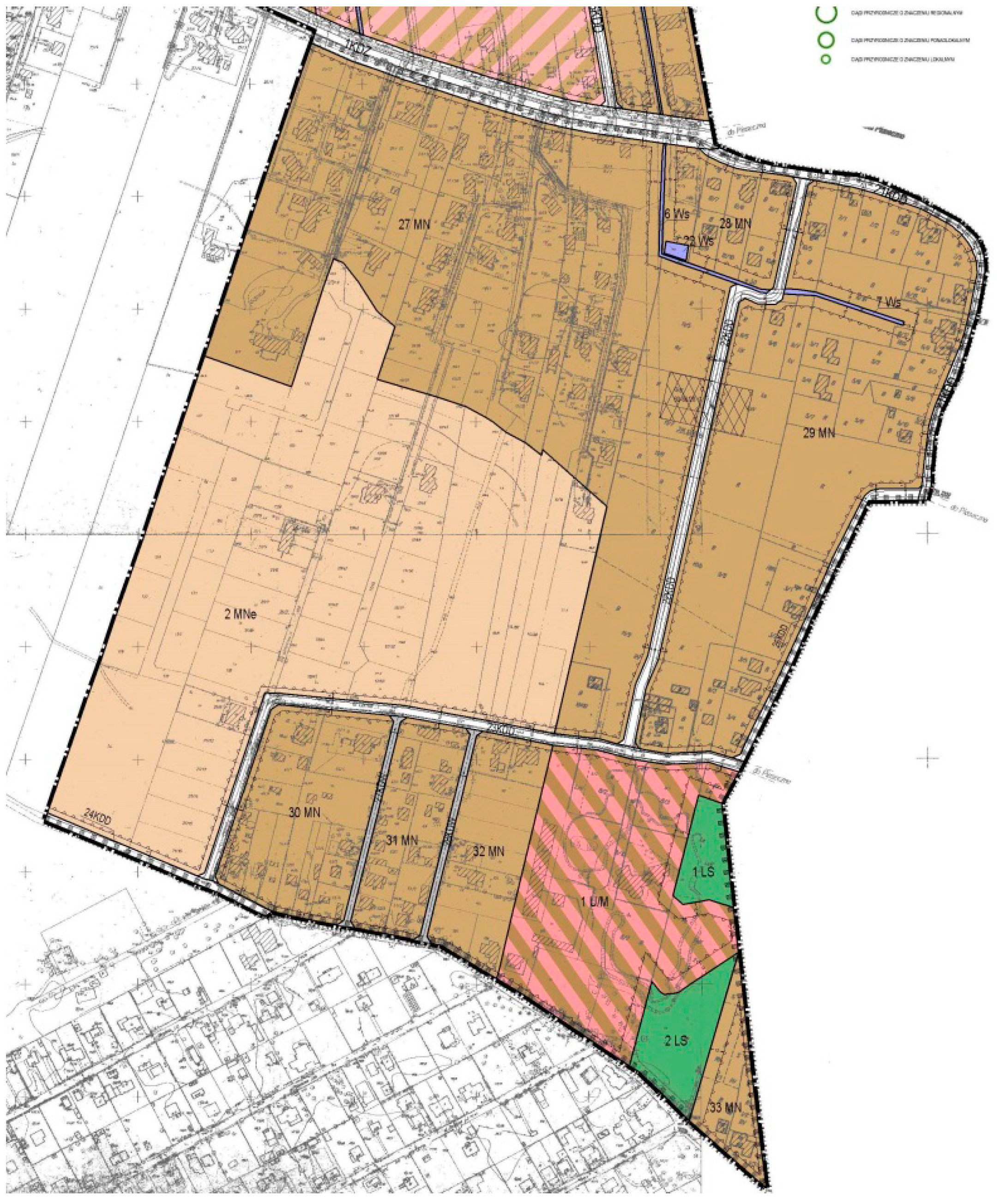
4. Case Studies: Examples and Discussion

Planning concepts and implemented projects, firstly, need to be holistic, and, secondly, must consider the needs and expectations of residents. In Poland, the Act of 27 March 2003 on spatial planning and spatial development adopts sustainable development as the basis for activities of entities responsible for spatial order (Article 1, Paragraph 1). Sustainable space is defined as space friendly to humanity. The lack of spatial order in Poland is a fact experienced daily by many people. This negative experience has a multi-aspect character and affects the social, economic as well as environmental sphere. Spatial disorder is a particular nuisance in urbanized areas due to a strong concentration of different forms of activity, building development, infrastructure and capital etc. [14].
The document adopted by the Board of Ministers in 2011 [44], in its diagnostic part, describes irregularities or even pathologies of spatial processes in Poland. It stipulates that, “a disorderly spatial development system results in specific effects in the social and economic sphere. They particularly include social problems in the form of pathologies, alienation, frustration, and conflicts resulting from social segregation (building development in suburbs based on closed housing estates with no public spaces friendly to residents, green areas, convenient access to good quality public services). Another effect of the lack of consistent spatial policy is uncontrolled urbanization, causing costs of construction of additional infrastructure that are not justified with economic balance, and the prolongation of travel time to the centre (to places of work, education, services)”. Due to the lack of adequate regulations in the spatial economy system (the lack of obligatory consolidations), the ownership-spatial structure of agricultural areas determined the shape of new building developments. This results in overtly extensive and chaotic building development, as well as the permanent exclusion of a part of land from use. The losses are estimated to reach 20% of each hectare allocated for construction [44]. With this type of residential building development, mutual financing mechanisms have no rational justification, and the costs of incurred loans for the construction of municipal infrastructure must be covered by all taxpayers, and not its direct users. This type of building development is at variance with the rule of sustainable development and social justice [14,44].
In Poland, the act governing spatial planning and spatial development puts property rights and the public interest on a par with the primary conditions of spatial planning and emphasizes the need to provide for the participation of society in planning works (Article 1, Paragraph 2). When determining the purpose of land or its potential development and use, the authority considers both public and private interests. This concerns reported requests and comments seeking to protect the existing state of land development and changes in the scope of its management, as well as economic, environmental and social analyses (Article 1, Paragraph 3).
Property rights, including the freedom to use real estate and its development, are under constitutional protection in Poland. Article 20 makes private property one of the pillars of the social market economy (next to the freedom of business activity, the solidarity and cooperation of social partners). Article 21 pertains to the rule protecting property and succession rights, one of the rules of the political system in the country (Paragraph 1). Evident identification of property as a public, subjective right was included in Article 64 of the Constitution in Chapter II, next to freedom and economic, social and cultural rights. Further on, the provision stipulates that the values (i.e., property, other property rights and succession rights) are subject to legal protection that is equal for all and that property can be limited only based on an act and only as long as it does not infringe the essence of the property rights. It is also worth mentioning the provision of Article 31, Paragraph 3 of the Constitution, which stipulates limitations in the scope of using constitutional freedoms and rights can be stipulated only in the form of an act, and only when they are necessary in a democratic state for its safety or public order, or for the protection of the environment, health, and public morality, or freedom and rights of other persons. The limitations cannot be at variance with the essence of freedom and rights [45].
One of the primary acts of Polish legislature regulating the rules of the use of real estate and its management is the Act of 27 March 2003 regarding spatial planning and spatial development. Pursuant to Article 1 of the act governing spatial planning (among others), property rights are taken into account (next to the requirement for spatial order, architectonic and landscape values, requirements for environmental protection, cultural heritage, safety and the health of people, economic values, and values related to defense and the public interest). The basic planning document (which constitutes an act of local law and regulates the implementation of property rights) is the local spatial development plan (Article 6, Paragraph 1), henceforth referred to as the local plan. Pursuant to Article 6, Paragraph 2, everyone has the right (within boundaries stipulated in the act) to manage land to which they have legal title in accordance with the conditions stated in the local spatial development plan (unless this conflicts with the legally protected public interest or the interests of third parties), as well as to protect their own legal interests in the management of land belonging to other persons or organizational entities. Pursuant to Article 3, Paragraph 1, the development and implementation of spatial policy in the territory of a commune, including passing local spatial development plans, is administered by the commune itself. Due to this, commune authorities are obliged to protect the public interest and the interest of particular real-estate owners. Spatial policy, expressed in local spatial development plans, is on a par with the protection of the environment, cultural heritage, landscape management and spatial order, and should also respect the property rights of all real-estate owners equally. Unfortunately, many arrangements included in local plans introduce dissonance between the scope for the use and development of particular land subject to such plans.
One of the most important features of real estate is its value, which is determined by many factors, including location, access to transportation, technical infrastructure, and its size and shape. The spatial parameters of a plot depend on the purposes for which the plot will be used and determine its functionality and the attractiveness of its development. Commune councils have various tools for shaping the spatial configuration of plots within the scope of local plans. Pursuant to Article 15, Paragraph 3 of the act governing spatial planning and spatial development, depending on the requirements, the local plan specifies the minimum land area of newly designated building plots (Point 10). This concerns plots obtained through the procedure for the division of real estate, described in Articles 92–100 of the act on real-estate economy (i.e., Journal of Laws, 2018, item 121, with further amendments). When the structure of plots allocated for purposes other than agriculture is not appropriate for the introduced function, commune councils can determine the boundaries of areas requiring land consolidation and division (Article 15, Paragraph 3, Point 1 of the act governing spatial planning and spatial development), implemented based on Articles 101–108 of the act relating to real-estate management. Councils are also obliged to specify detailed rules and conditions for the consolidation and division of land covered by the local plan. It is worth emphasizing the facultative character of areas requiring consolidation and secondary division. The act also does not stipulate regulation of the spatial configuration of plots [46].
Considering the above, the authors conducted an analysis of the spatial configuration of registered plots which are highly likely to be allocated for building development. Research conducted in communes directly adjacent to the administrative boundaries of the city of Warsaw (forming a compact ring), Figure 1 showed substantial problems with the spatial structure of plots. The research covered a total area of 104,013 ha. General land use in this area is presented in Table 1. In Poland, forests and forest land are not used for building development in accordance with the act governing protection of arable and forest land. It was, therefore, assumed that future building development would focus on agricultural land. Due to this, potential land for building development occupies 31% (32,212 ha) of the entire study area. An assessment was undertaken of the shape of 75,842 plots. The smallest of these had an area of 250 m2, and the largest was 861,640 m2. Optimal conditions in terms of width (more than 20 m) were met by 62.6% of the total number of plots, occupying as much as 83.4% of the total area of plots. Plots with a width of up to 5 m represented 2.2% of the total, which practically excludes them from building development (Table 2). Nonetheless, the width of plots is not the most substantial problem. A factor inhibiting the feasibility of using land for building development is the elongation of the plots. In the study area, as much as 67.6% of the total number of plots exceeded an elongation ratio of 1:2 (Table 3). These occupy 78.2% of the study area. It should be emphasized that a plot with a width-to-length ratio of approximately 1:2 is optimal for a single-family housing development. It is not practicable to develop plots with an elongation of more than 1:2.
The current legal status and unfavorable spatial structure of registered plots (particularly their excessive elongation) leads to situations in which the individual actions of landowners, implemented pursuant to the mandatory provisions of local plans, reduce the attractiveness (and, therefore, the value) of neighboring real estate. An example of such a situation is a fragment of the area of Komorów-Wieś in Michałowice Commune, located about 20 km to the southwest of the center of Warsaw. These land plots were formerly under agricultural use, and subsequently allocated for residential building development. The local plan for this area does not require mandatory land regulation by means of consolidation and secondary division. In the plan drawing, proposed division lines were introduced, however, explicitly suggesting the need to combine two and four adjacent plots, respectively. The situation is presented in Figure 2. Due to the loophole concerning implementation of the arrangements, landowners performed land consolidation and division of three adjacent plots, instead of the two specified in the local plan.
The lack of any information in the local plan regarding the necessity of carrying out a consolidation and effective land division led to a situation in which the owners of plots made an individual consolidation and the secondary division of a number of plots that was different to those proposed in the plan. As a result, the remaining plots, even in the case of merging and dividing, do not allow the possibility of obtaining the plots established in the plan with a plot ratio of about 1:2 (source: authors’ elaboration based on data from geoportal.gov.pl and the local spatial development plan [47]).
As a result, the remaining part of the area (between new building plots and the road designated in the local plan) left no scope for obtaining investment plots with comparable parameters. Their attractiveness and value have diminished as a result. It may also be the case that the implementation of the provisions of the plan (and, therefore, land development) in accordance with the intended purpose has now been rendered impossible.
Aside from reducing land value, a lack of action on the part of commune authorities (in terms of preparation of investment land for the introduction of a new function), in many cases, also leads to situations in which the use of land for various purposes is rendered impossible. The lack of a decision on complex regulation of the spatial structure of plots, transportation and technical infrastructure from the perspective of the individual actions of private owners can lead to the occurrence of enclaves in building development. This is particularly evident in areas for which no local plans were passed, and building development is based on decisions about the conditions of building development. Intensive building development, particularly housing, can lead to a situation in which certain sections of plots cannot be subject to division into smaller building plots, and are then developed in accordance with the functions that predominate in particular areas or in accordance with the purpose in the plan. Such a situation can be seen in the area of the Brwinów Commune, located about 30 km to the southwest of the center of Warsaw (Figure 3).
One particular plot, formerly under agricultural use, like other plots in the vicinity, was long and densely surrounded by buildings. The parameters of the real estate, particularly its width, did not permit the introduction of an internal road that would provide access for potential building plots. Due to this, the real estate was deemed unsuitable for building development. It should be noted, however, that the development of adjacent plots limited to a considerable extent (possibly even rendering impossible) the maintenance of the existing agricultural function. The shading of the area and the strong urbanization of adjacent plots led to a situation where use of this real estate was virtually prohibited, directly contributing to a reduction in the value of the currently unused real estate.
Transportation infrastructure is an important parameter of each plot. Besides issues of spatial order, Article 7 of the act regulating self-government of the commune provides for real estate management, environmental protection and water management, and commune tasks, including, among other things, roads, streets, bridges, squares and organization of road traffic. To protect spatial order, pursuant to the content of the binding plans, communes should introduce building development lines along transportation land and a road network, facilitating access to investment land. The commune is also obliged to bear compensation costs in respect of land adopted for transportation infrastructure, and the costs of its implementation [49]. It should be noted, however, that administrative court rules in this regard indicates no obligation on the part of the commune authority to provide all real estate with direct access to a public road. The local plan specifies the basic transportation network. When an investor plans the performance of detailed land divisions based on a local plan, the real estate should be given access to a public road [50]. Due to this, commune authorities preparing local plans frequently avoid designating a road network to connect the area under development. This particularly concerns communes that are prone to allocating excessive amounts of land for housing development. An example of such a situation in relation to spatial policy is a fragment of the local plan for the Jazgarzewszczyzna village in the Lesznowola Commune, located about 25 km to the south of the center of Warsaw [51] (Figure 4).
In the local plan, the entire discussed area was allocated for single-family housing development, and service and housing development areas. In addition to the existing roads, one public access road was designated. Due to this, the remaining part of the area is due to be supported by private internal roads. It is worth emphasizing that at the stage of drafting the plan, the area was already partially built up. Interestingly, parts of the existing roads were not adopted as public roads in the local plan. Due to this, new building plots established in the area (without direct access to public roads designated in the plan) will need to be supported by private internal roads. This is an example of the unequal balancing of the interests of owners of particular plots covered by the local plan. Plots located along public roads have a higher value, and the cost of road construction is covered by the commune rather than the owner (as with other plots located within the area). The situation also has a practical aspect for future users. The technical conditions of roads, their management and maintenance (in the case of public roads) are regulated by the act governing public roads, obliging the road administrator to maintain the road in a proper state. The provisions of the act do not concern internal roads remaining in the possession of private persons. This leads to frequent situations where housing estates are located by a dirt road with no pavements or street lighting.
The problems presented in these case studies concern plots formerly under agricultural use and subsequently reallocated for building development. The binding law allows for a systemic solution to the problem of ownership and spatial structure of plots allocated for building development through application of the procedure for division, consolidation and secondary division, or consolidation and division of land. Unfortunately, the most frequently applied procedure is division, with consolidation and division of land rarely implemented. Research (e.g., [52]) shows that the basic cause is insufficient financial resources and sociological problems, such as residents not agreeing with the application of the land consolidation procedure.

5. Results

5.1. Planning Models Used in European countries

In European countries, the standards of a democratic, legal state within the scope of spatial planning can designate, among other things, that planning processes for building development should strike the right balance between public and private interests and involve actual social participation. Opportunities for building development must be related to the state of infrastructure development, the expansion of which is a public duty [53]. In most European countries, particular attention is paid to sustainable development, emphasizing environmental protection and the participation of society in spatial planning. The analysis of spatial planning systems indicates many interesting solutions permitting the participation of residents and their actual influence on land development.
In many European countries, residents are directly involved in the procedure for the preparation of spatial development plans and at a later stage of the implementation of particular investments, e.g., in England, where announcements are published and debates are organized on planned investments involving the participation of residents in neighboring plots; or in Finland, where residents express opinions on investments planned in their neighborhood. Finland, a country that particularly values local community opinion, also has other solutions, i.e., creating groups of stakeholders that cooperate with the architects of plans [54]. Geographical Information System (GIS) tools are also commonly applied for social diagnosis of the quality of space in the form of bottom-up action (bottom-up GIS) and participatory GIS [55,56]. In many European countries, social participation has a practical aspect characterized by negotiation, e.g., in Spain, where communes must reach an understanding with landowners in reference to planned solutions [54]. The participation of residents in spatial planning also has a practical aspect. In France, urban plans are prepared, constituting an instrument of urban planning negotiation with residents for the purpose of preparing a draft development plan for a given area [54]. The provisions of such drafts are considered in prepared spatial development plans [57].
European countries also pay attention to ensuring justice and equal possibilities for development in particular regions. For this purpose, in Finland and Sweden, the parameters of plots are verified, provision is made for a transportation system, and infrastructure in plots allocated for investments. In France, new building development depends on the infrastructure and development of neighboring areas. Germany imposes an obligation to perform land consolidation and division, and the construction of necessary infrastructure before the building development can commence in a given area. It is also worth emphasizing that in the German system, economic development and investments are no longer the primary objective of planning. Particular attention is currently paid to the provision of sustainable living conditions and the equalization of spatial conflicts concerning land use [54].
The analysis of spatial planning systems in European countries highlights, in particular, residents’ participation in the preparation of development plans and the implementation of investments. In many countries, different and more extensive forms of social participation are also introduced in addition to those stipulated in legal provisions. It should be noted that most societies provide for practical participation in the preparation of plans at virtually all stages. In many cases, the implementation of an investment depends on arrangements made with the owners of neighboring land. Aside from meeting the need for sustainable development, most European countries emphasize aspects of the common good, also called social duty, which is predominant over property rights [58]. This ensures balance and social justice. It also helps increase residents’ awareness of the need to protect spatial order, the environment and landscape. It also increases the levels of trust between residents and local authorities, and more extensive participation in the preparation of spatial development plans.

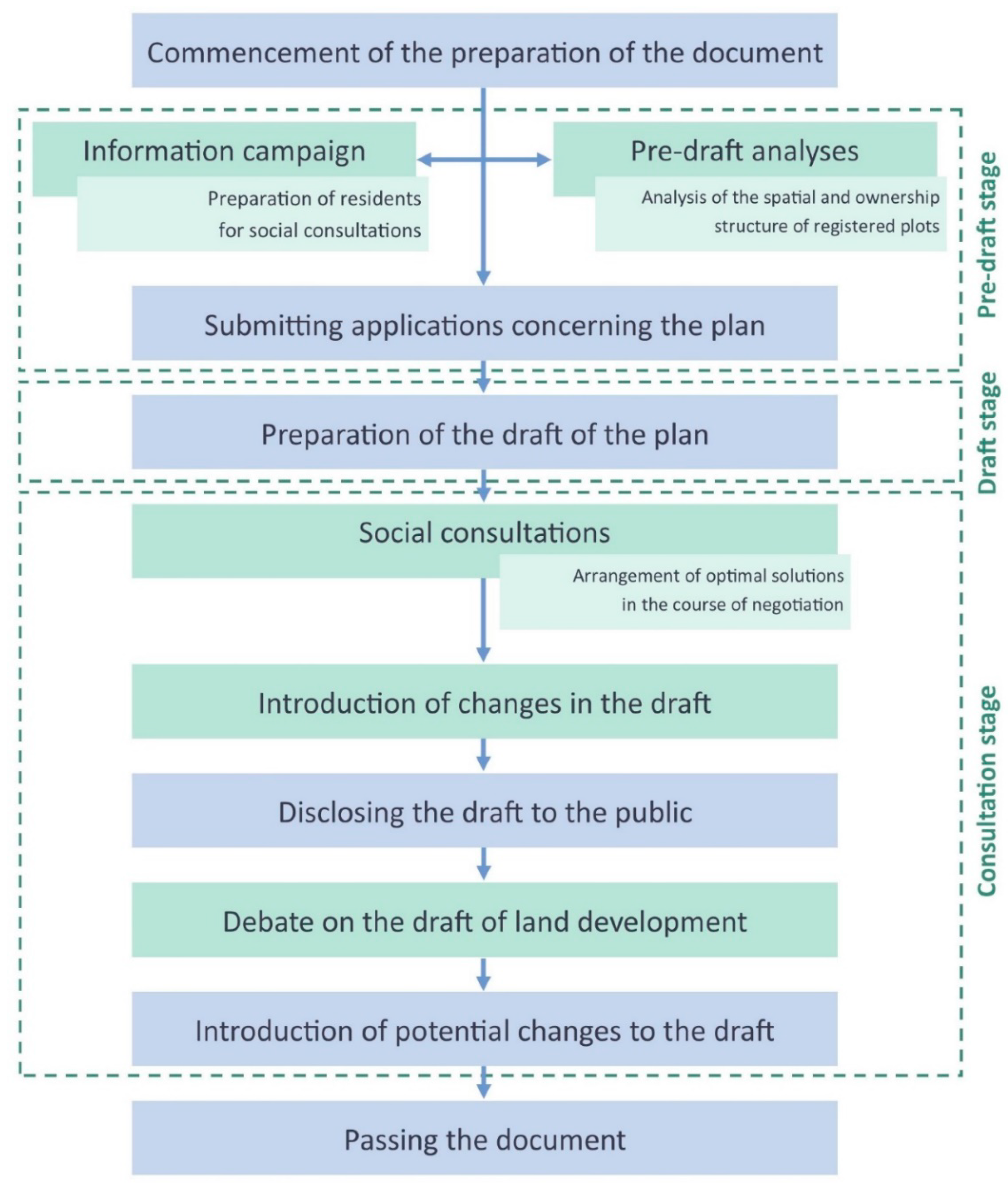
5.2. The Planning Model Used in Poland

Pursuant to the provisions of the act governing spatial planning and spatial development, residents should be provided with opportunities for active participation in preparatory work for the study. The success of such activities depends on the cooperation between commune authorities and the local community [59]. In reality, although residents participate in social consultations, they often have no knowledge concerning possible design solutions and their effects. This leads to comments about plans being filed, which are at variance with their scope or provisions and higher order documents. This closes the vicious circle of aversion that designers and decision-making parties have to the participation of residents, and convinces residents that their applications and comments have no chance for consideration [60]. This creates a situation where residents do not execute their rights related to the use of real estate. They do not always realize that they will not be able to develop their land in accordance with its purpose in the local spatial development plan because the existing shape of the land (e.g., a plot 6 m wide and 800 m long) will not permit this. This is often associated with a reduction in the value of real estate in situations involving the development of an excessively narrow plot surrounded by roads on both sides. Some owners are not interested in any changes, considering them unnecessary. They also fear fees resulting from the implemented procedures. Local authorities making decisions on expenditure for the development of public areas and infrastructure resulting from planning works and surveying procedures (e.g., land consolidation and division) usually do not realize the negative long-term effects of flawed development. Diligently informing residents of the effects of proposed changes can provide an opportunity to engage in meaningful discussion and make joint arrangements for optimal solutions with the decision-making parties in the course of negotiations. Professional planners should use the theoretical and empirical knowledge they have obtained from analyses of various case studies so that the design solutions are optimal [61].

5.3. The Proposed Solutions

Research points to the need for changes in the manner and scale of the allocation of agricultural land for residential purposes. Ensuring sustainable development, however, requires the participation of local communities and understanding of the objectives of proposed changes. According to the present authors, the most optimal solution would be the performance of detailed analyses at the study stage, considering the conditions and directions of spatial development (study) for the entire area of the commune, with much greater involvement by residents. Sustainable development will only have a chance if rationally determined directions of change are discussed with representatives from all sections of the commune. Within the current legal framework, the preparation of a study draft is preceded by distribution of applications to residents. The draft of the study is disclosed and publicly debated, and the final document should reflect the comments of residents.
It is, therefore, justifiable to introduce mechanisms for the rational determination of directions of development in communes, involving cooperation with local communities during the planning process, in order to make space management as socially equitable as possible. The original methodology for changes to the system is presented in Figure 5, proposing the introduction of a pre-design stage aimed at performing preliminary analyses showing the possibilities for development and the need to apply relevant procedures, e.g., land consolidation and division, for the purpose of ensuring rational development. The authors also propose conducting an extensive information campaign aimed at engaging a broad cross-section of residents and preparing them for social consultations. This preparation should occur through information meetings addressing various issues: the essence and scope of the stipulations of planning documents, the possibilities for development based on analyses undertaken, and the benefits and effects of planned procedures. As emphasized by Natarajan [21], such meetings/workshops should create the possibility for mutual exchange of thoughts, opinions and experiences between the local community, financing institution (which, in the case of Poland, is the commune), planners and specialists from other disciplines, including ecologists, landscape architects and surveyors. Applications should only be submitted after this preparatory stage, and a draft of planning documents could be prepared. Another innovation is the introduction of obligatory social consultations (at the arrangements stage) in the form of workshops. In the presence of designers, the draft planning documents would be presented in detail, considering costs, financing, effects of the proposed solutions and long-term benefits. Consultations would take the form of negotiation between stakeholders and would end in reaching a common position. After the introduction of changes to the draft, the plan would be disclosed to the public and subjected to public debate. Unlike the current process for applying solutions, the debate would not only be based on the draft plan but also on the conceptual draft, in particular, and its visualization. The development draft and 3D visualizations facilitate understanding of some assumptions of the plan, i.e., the building development layout, transportation system or landscape aspects. The introduction of this kind of consultation aims to facilitate the process of informing residents about the possibilities for land development in accordance with the provisions of the draft plan. After incorporating potential comments into the draft, the plan would then be passed.
The proposed solutions would offer an opportunity to make all interested parties aware of the effects of the approved planning documents and the possibilities for the development of their own land. Currently, residents are seldom aware of the procedure for land consolidation and division pursuant to the binding act controlling real-estate management. Most residents also do not know the exact costs they would have to incur due to such procedures and what benefits they would obtain. Due to this, residents usually show a skeptical attitude towards proposed new developments—unaware that plots owned by some of them do not meet the parameters stipulated in local spatial development plans, which will, as a result, be deemed unfit for purpose. For example, the local spatial development plan specifies that the minimum plot width must be 20 m, but the owner has a 5 m plot, therefore he will not be able to use it in accordance with the local spatial development plan. According to the authors, this is a kind of social/spatial injustice to which residents are exposed.
Similar solutions have already suggested in, among by others, in the draft amendment to the act governing spatial planning and spatial development, emphasizing the necessity for information campaigns and social participation to be effected at an early stage of the planning procedure [62]. However, in the current legal framework, commune self-governments also have the opportunity to organize additional, more extensive forms of consultation, although this is not common practice. An excellent example is Gdynia Infobox, where anyone can familiarize themselves with the city’s development plan for the upcoming years, presented in interactive images and a 3D model of the city. You can, among other things, take a virtual walk to see the effects of implemented or planned investments. Gdynia Infobox is also a place for investors and urban planners to meet and discuss planned changes. A space for children is even provided, where they can create their own vision of the city using building blocks. The described example is one of several, but it is certainly an exemplary way of promoting cooperation with residents, and this kind of urban design is gaining popularity all over the world.
In the Polish context, in terms of the scope for reaching optimal planning solutions with a sense of spatial justice, it is also very important to provide sources of finance for workshops and social consultations, as well as interdisciplinary cooperation between specialists with an influence on spatial planning [63]. In the case of improving the spatial structure of registered plots, it is highly important to ensure cooperation with surveyors dealing with real-estate management and the transformation of the ownership structure. This would permit more extensive information campaigns, mutual learning of stakeholders and the development of a social model of spatial planning that permits more just solutions for all residents.

6. Conclusions

Achieving spatial justice in the context of spatial planning is very difficult. It requires cooperation and mutual understanding among all stakeholders involved in the process. In Poland, one of the key factors contributing to a lack of spatial justice in the scope of housing development in post-agricultural areas is the unfavorable structure of registered plots. In extreme cases, this can limit or render impossible the development of plots in accordance with their purpose in the local spatial development plan, substantially decreasing the value of particular real estate. The original methodology for the preparation of planning documents discussed in this article proposes that the analysis of the structure of plots and an extensive information campaign prior to the commencement of the preparation of planning documents make it possible to reconcile the interests of all individual participants in the process of spatial planning, both the community and the local authorities responsible for financing the investment.
In the context of allocating agricultural land for housing purposes in the proposed model, it is crucial to introduce detailed analyses providing the answer to the need to adapt the geometry of plots for a new function through the obligatory use of consolidation procedures. Plots with unfavorable geometry, often unsuitable for agricultural use, also do not allow their development in accordance with the new purpose in the plan. The introduced solution, apart from adapting the areas previously used for agriculture for housing development, is also aimed at improving the quality of the new development. However, it is necessary to make landowners aware of all the economic, spatial and landscape benefits, as a part of extended public consultations, which will ultimately translate into achieving social and spatial justice.

Author Contributions

Formal analysis, A.B., A.W. and M.D.; Investigation, A.B., A.W. and M.D.; Methodology, A.B., A.W. and M.D.; Project administration, Anna Bielska; Resources, A.W. and M.D.; Supervision, A.B.; Writing—original draft, A.B., A.W. and M.D.; Writing—review & editing, A.B., A.W. and M.D. All authors have read and agreed to the published version of the manuscript.

Conflicts of Interest

The authors declare no conflict of interest.

References

  1. Harvey, D. Rebel Cities: From the Right to the City to the Urban Revolution; Verso Books: London, UK; New York, NY, USA, 2012; p. 187. [Google Scholar]
  2. Fainstein, S.S. Spatial Justice and Planning. In Readings in Planning Theory, 4th ed.; Wiley-Blackwell: Chichester, UK, 2016; pp. 258–272. [Google Scholar]
  3. Soja, E.W. Seeking Spatial Justice; University of Minnesota Press: Minneapolis, MN, USA, 2010. [Google Scholar]
  4. Bański, J. (Ed.) Polska przestrzeń wiejska: Procesy i perspektywy [Polish rural space: Processes and perspectives]. Studia Obszarów Wiejskich 2004, VI, 249. (In Polish) [Google Scholar]
  5. Dudzińska, M.; Kocur-Bera, K. Rural development programme in Poland, the Czech Republic and Austria. Geomat. Land Manag. Landsc. 2014, 4, 49–64. [Google Scholar] [CrossRef]
  6. Wójcik-Leń, J.; Leń, P.; Sobolewska-Mikulska, K. The proposed algorithm for identifying agricultural problem areas for the needs of their reasonable management under land consolidation works. Comput. Electron. Agric. 2018, 152, 333–339. [Google Scholar] [CrossRef]
  7. Raszkowski, A.; Bartniczak, B. Sustainable Development in Central and Eastern European Countries (CEECs): Challenges and Opportunities. Sustainability 2019, 11, 1180. [Google Scholar] [CrossRef] [Green Version]
  8. Dragomirescu, H.; Bianco, L. Rozwój zrównoważony z perspektywy systemowej: Podejście kontekstowe [Tackling Sustainability from a Systemic Perspective: A Contextualized Approach]. Probl. Sustain. Dev. 2017, 12, 31–39. (In Polish) [Google Scholar]
  9. Wolsink, M. “Sustainable City” requires “recognition”—The example of environmental education under pressure from the compact city. Land Use Policy 2016, 52, 174–180. [Google Scholar] [CrossRef]
  10. Geppert, A. Vae Victis! Spatial Planning in the Rescaled Metropolitan Governance in France. Spat. Res. Plan. 2017, 75, 225–241. [Google Scholar] [CrossRef] [Green Version]
  11. Jovovic, R.; Draskovic, M.; Delibasic, M.; Jovovic, M. The concept of sustainable regional development—Institutional aspects, policies and prospects. J. Int. Stud. 2017, 10, 255–266. [Google Scholar] [CrossRef] [PubMed] [Green Version]
  12. Trindade, E.P.; Hinnig, M.P.; da Costa, E.M.; Marques, J.S.; Bastos, R.C.; Yigitcanlar, T. Sustainable development of smart cities: A systematic review of the literature. J. Open Innov. Technol. Market Complex. 2017, 3, 11. [Google Scholar] [CrossRef] [Green Version]
  13. Sztumski, W. Responsible Development and Durable Development. Probl. Sustain. Dev. 2018, 13, 113–120. [Google Scholar]
  14. Sobol, A. Gospodarka przestrzenna a lokalny rozwój zrównoważony [Spatial management versus local sustainable development]. Ekonomia Środowisko 2013, 3, 70–78. (In Polish) [Google Scholar]
  15. The 2030 Agenda for Sustainable Development; United Nations General Assembly: New York, NY, USA, 2015; p. 35.
  16. The Urban Agenda for the EU. 2016. Available online: https://ec.europa.eu/futurium/en/urban-agenda (accessed on 19 November 2019).
  17. The State of European Cities 2016—Cities Leading the Way to A Better Future; European Commission: Brussels, Belgium, 2016; p. 216.
  18. Tutuko, P.; Shen, Z. The effect of land use zonings on housing development: The introduction of cdl approach in the border area of Surabaya and Sidoarjo Regency, Indonesia. Procedia Soc. Behav. Sci. 2016, 227, 107–114. [Google Scholar] [CrossRef] [Green Version]
  19. Wojtyra, B. Zasoby lokalne w planowaniu przestrzennym centrum wsi—studium przypadku Rokietnicy [Local resources in spatial planning of the village centre—Case study of Rokietnica]. Studia Obszarów Wiejskich 2017, 45, 125–140. [Google Scholar] [CrossRef]
  20. Dacko, M. The Issue of Environmental Resources Management in the Light of the Model of Tragedy of the Commons—Systemic Approach. Probl. Ekorozwoju Probl. Sustain. Dev. 2015, 10, 21–30. [Google Scholar]
  21. Natarajan, L. Socio-spatial Learning: A Case Study of Community Knowledge in Participatory Spatial Planning. Prog. Planning 2017, 111, 1–23. [Google Scholar] [CrossRef] [Green Version]
  22. New Urban Agenda; United Nations: Quito, Ecuado, 2017. Available online: http://habitat3.org/wp-content/uploads/NUA-English.pdf (accessed on 10 November 2019).
  23. Meng, Q. Fracking equity: A spatial justice analysis prototype. Land Use Policy 2018, 70, 10–15. [Google Scholar] [CrossRef]
  24. Agyeman, J.; Bullard, R.D.; Evans, B. Exploring the Nexus: Bringing Together Sustainability. Environmental Justice and Equity. Space Polity 2002, 6, 77–90. [Google Scholar] [CrossRef]
  25. Bryner, G. Environmental Justice. In Oxford Research Encyclopedia of International Studies; Oxford University Press: Oxford, UK, 2017. [Google Scholar]
  26. Raymond, C.M.; Gottwald, S.; Kuoppa, J.; Kyttae, M. Integrating multiple elements of environmental justice into urban blue space planning using public participation geographic information systems. Landsc. Urban Plan. 2016, 153, 198–208. [Google Scholar] [CrossRef]
  27. Pearsall, H.; Pierce, J. Urban sustainability and environmental justice: Evaluating the linkages in public planning/policy discourse. Local Environ. 2010, 15, 569–580. [Google Scholar] [CrossRef]
  28. Fuller, T.K. Mapping Environmental Justice: A Framework for Understanding Sustainability at the Neighborhood Scale in Indianapolis. In Urban Sustainability: Policy and Praxis; Springer: Cham, Switzerland, 2016; pp. 201–215. [Google Scholar]
  29. Novak, M. Three in One: Essays on Democratic Capitalism. 1976–2000; Younkins, E.W., Ed.; Rowman & Littlefield: Lanham, MD, USA, 2001. [Google Scholar]
  30. Hollenbach, D. The Common Good and Christian Ethics; Cambridge University Press: Cambridge, UK, 2002. [Google Scholar]
  31. Stoiński, A. Przeobrażenia idei sprawiedliwości społecznej część I: Sprawiedliwość społeczna jako sprawiedliwość ogólna i rozdzielcza [Transformations of the ides of social justice, Part I: Social justice as general and distributional justice]. Roczniki Filozoficzne 2018, LXVI, 1–5. (In Polish) [Google Scholar] [CrossRef]
  32. Bret, B.; Gervais-Lambony, P.; Hancock, C.; Landy, F. Justices et Injustices Spatiales; Presses Univeritaires de Paris Ouest: Paris, France, 2010; p. 316. [Google Scholar]
  33. Gutwald, R.; Leßmann, O.; Masson, T.; Rauschmayer, F. A Capability Approach to Intergenerational Justice? Examining the Potential of Amartya Sen’s Ethics with Regard to Intergenerational Issues. J. Hum. Dev. Capab. 2014, 15, 355–368. [Google Scholar] [CrossRef]
  34. Rocco, R. Why Discuss Spatial Justice in Urbanism Studies? 2014. Available online: https://repository.tudelft.nl/islandora/object/uuid:2c58a10d-3ebd-437a-a8ce-c6b2fd2f1777/datastream/OBJ/download (accessed on 20 November 2019).
  35. Wigmans, G. Contingent governance and the enabling city. City 2001, 5, 203–223. [Google Scholar] [CrossRef]
  36. Papadopoulos, Y. Problems of Democratic Accountability in Network and Multilevel Governance. Eur. Law J. 2007, 13, 469–486. [Google Scholar] [CrossRef]
  37. Avritzer, L. Living under democracy: Participation and its impact on the living conditions of the poor. J. Lat. Am. Stud. Assoc. 2010, 45, 166–185. [Google Scholar] [CrossRef] [PubMed]
  38. Un-Human Rights. Good Governance and Human Rights. 2014. Available online: http://www.ohchr.org/en/Issues/Development/GoodGovernance/Pages/GoodGovernanceIndex.aspx (accessed on 10 April 2014).
  39. Świątek, D. Kształtowanie przestrzeni a planowanie przestrzenne—doświadczenia angielskie. MAZOWSZE Stud. Reg. 2011, nr 6, 173–180. [Google Scholar]
  40. Brunn, S.D. Geography and Politics in America; Harper and Row: New York, NY, USA, 1974. [Google Scholar]
  41. Johnson, H.B. Order Upon the Land: The U.S. Rectangular Land Survey System and the Upper Mississippi Country; Oxford University Press: New York, NY, USA, 1976. [Google Scholar]
  42. White, A. A History of the Rectangular Survey System; U.S. Department of the Interior Bureau of Land Management: Washington, USA, 1983.
  43. Webster, G.R.; Leib, J. Living on the Grid: The U.S. Rectangular Public Land Survey System and the Engineering of the American Landscape. In Engineering Earth; Brunn, S., Ed.; Springer: Dordrecht, The Netherlands, 2011; pp. 2123–2138. [Google Scholar]
  44. KPZK. Koncepcja Przestrzennego Zagospodarowania Kraju 2030 [Concept of Spatial Development of the Country 2030]. In Proceedings of the Uchwała Rady Ministrów z Dnia, 13 Grudnia 2011 roku 239/2011 [Resolution of the Council of Ministers, Warsaw, Poland, 13 December 2011]; pp. 160–161. (In Polish).
  45. Doganowski, R. Konstytucyjne gwarancje ochrony własności nieruchomości [Constitutional guarantees of protection of real estate]. Doradca Rynku Nieruchomości. 2017, 4, 8–9. (In Polish) [Google Scholar]
  46. Ustawa z dnia 27 marca 2003 r. o planowaniu i zagospodarowaniu przestrzennym (t.j. Dz.U. 2017 poz. 1073 z późn. zm.) [Act of 27 March 2003 on spatial planning and spatial development (i.e., Journal of Laws 2017, item 1073 with further amendments)]. (In Polish). Available online: http://prawo.sejm.gov.pl/isap.nsf/download.xsp/WDU20030800717/U/D20030717Lj.pdf (accessed on 15 December 2019).
  47. Uchwała Nr XLIV/412/2006 Rady Gminy Michałowice z dnia 13 października 2006 r. w sprawie zatwierdzenia miejscowego planu zagospodarowania przestrzennego Gminy Michałowice obszaru “Komorów”—Część VI obejmująca fragment wsi Komorów [Resolution No. XLIV/412/2006 of the Council of the Michałowice Commune of 13 October 2006 regarding the approval of local spatial development plan of the Michaowice Commune, area “Komorów”—Part VI covering a fragment of the Komorów village] (In Polish). Available online: https://bip.michalowice.pl/prawo-miejscowe/uchwaly-rady/2006/sesja-rady-nr-xliv/uchwala-nr-xliv4122006-rady-gminy-michalowice-z-dnia-13-pazdziernika-2006r,p913805938 (accessed on 12 September 2019).
  48. National Geoportal. Available online: https://mapy.geoportal.gov.pl/imap/Imgp_2.html?gpmap=gp0 (accessed on 12 September 2019).
  49. Hełdak, M.; Stacherzak, A.; Kazak, J. Problemy realizacji ustaleń planu miejscowego w zakresie komunikacji na obszarach wiejskich. Infrastruktura i ekologia terenów wiejskich [Problems in the implementation of arrangements of a local plan in the scope of transport networks in rural areas]. Polska Akademia Nauk. 2012, III, 79–88. (In Polish) [Google Scholar]
  50. Wyrok WSA w Gdańsku z 2010-12-15 sygn. II SA/Gd 604/10 [Court decision of the Voivodeship Administrative Court in Gdańsk of 2010-12-15, Ref. II SA/Gd 604/10] (In Polish). Available online: http://www.orzeczenia-nsa.pl/wyrok/ii-sa-gd-604-10,miejscowy_plan_zagospodarowania_przestrzennego_skargi_na_uchwaly_rady_gminy_w_przedmiocie_art_i,200c072.html (accessed on 12 September 2019).
  51. Uchwała nr 618/XLVI/2014 Rady Gminy Lesznowola z dnia 22 października 2014 r. w sprawie uchwalenia miejscowego planu zagospodarowania przestrzennego gminy Lesznowola dla części wsi Jazgarzewszczyzna i części wsi Łoziska [Resolution No. 618/XLVI/2014 of the Council of the Lesznowola Commune of 22 October 2014 regarding passing the local spatial development plan of the Lesznowola Commune for a part of the Jazgarzewszczyzna village and part of the Łoziska village]. (In Polish). Available online: https://www.infor.pl/akt-prawny/U73.2015.054.0002479,uchwala-nr-618xlvi2014-rady-gminy-lesznowola-w-sprawie-uchwalenia-miejscowego-planu-zagospodarowania-przestrzennego-gminy-lesznowola-dla-czesci-wsi-jazgarzewszczyzna-iczesci-wsi-loziska.html (accessed on 18 September 2019).
  52. Siuta, J.; Żukowski, B. Polskie dylematy scalania gruntów i urządzania terenów wiejskich Część 1. Scalanie gruntów [Polish dilemmas of land consolidation and development of rural areas, Part 1: Land consolidation]. Inży. Ekol. Ecol. Eng. 2018, 19, 1–16. (In Polish) [Google Scholar] [CrossRef]
  53. Izdebski, H.; Nelicki, A.; Zachariasz, I. Zagospodarowanie przestrzenne. Polskie prawo na tle standardów demokratycznego państwa prawa, Sprawne Państwo [Spatial Planning: Polish Law in the Context of Standards of a Democratic, Efficient State]; Ernst & Young: Warsaw, Poland, 2007. (In Polish) [Google Scholar]
  54. Zakrzewska-Póltorak, A. (Ed.) Planowanie Przestrzenne w Europie [Spatial Planning in Europe]; Wydawnictwo Uniwersytetu Ekonomicznego we Wrocławiu: Wroclaw, Poland, 2016; p. 204. (In Polish) [Google Scholar]
  55. Jankowski, P. Towards participatory geographic information systems for community-based environmental decision-making. J. Environ. Manag. 2009, 90, 1966–1971. [Google Scholar] [CrossRef]
  56. Sieber, R. Public participation geographic information systems: A literature review and framework. Ann. Assoc. Am. Geogr. 2006, 96, 491–507. [Google Scholar] [CrossRef]
  57. Topczewska, T. Zintegrowane planowanie rozwoju i rewitalizacji miast w wybranych krajach “starej” Unii Europejskiej i w Polsce [Integrated planning of development and revitalization of cities in selected countries of the “old” European Union and in Poland]. Człowiek Środowisko 2010, 34, 5–25. (In Polish) [Google Scholar]
  58. Jędraszko, A.; Bagiński, L. Planowanie Przestrzenne w Niemczech Zarys System [Spatial Planning in Germany: Overview of the System]. In Planowanie i realizacja przedsięwzięć urbanistycznych [Planning and Implementation of Urban Planning Undertakings]; Lorens, P., Martyniuk-Pęczek, J., Eds.; Akapit-DTP: Gdańsk, Poland, 2011; pp. 46–84. (In Polish) [Google Scholar]
  59. Pomianek, I. Poziom rozwoju spoeczno-gospodarczego obszarów wiejskich województwa warmisko-mazurskiego [Socio-economic development level of rural areas of Warmia and Mazury province]. Acta Sci. Pol. Oecon. 2010, 9, 227–239. [Google Scholar]
  60. Happach, M.; Komorowska, M. Czy mieszkańcy mogą zastąpić projektanta? [Can residents replace the designer?]. In Partycypacja społeczna w planowaniu przestrzennym—Konferencja Towarzystwa Urbanistów Polskich Oddziału w Warszawie oraz Biura Architektury i Planowania Przestrzennego Urzędu m.st. Warszawy [Social Participation in Spatial Planning—Conference of the Society of Polish Town Planners of the Municipal Office of the Capital City of Warsaw]; Wyd. Towarzystwo Urbanistów Polskich, Oddział w Warszawie: Warsaw, Poland, 2014. (In Polish) [Google Scholar]
  61. Tennøy, A.; Hansson, L.; Lissandrello, E.; Næss, P. How planners’ use and non-use of expert knowledge affect the goal achievement potential of plans: Experiences from strategic land-use and transport planning processes in three Scandinavian cities. Prog. Plan. 2016, 109, 1–32. [Google Scholar] [CrossRef] [Green Version]
  62. Projekt Ustawy o Zmianie Ustawy o Planowaniu i Zagospodarowaniu Przestrzennym Oraz Niektórych Innych ustaw; Ministerstwo Infrastruktury i Rozwoju: Warsaw, Poland, 2015. (In Polish)
  63. Scott, A.; Carter, C.; Reed, M.; Larkham, P.; Adams, D.; Morton, N.; Waters, R.; Collier, D.; Crean, C.; Curzon, R.; et al. Disintegrated development at the rural-urban fringe: Re-connecting spatial planning theory and practice. Prog. Plan. 2013, 83, 1–52. [Google Scholar] [CrossRef] [Green Version]
Figure 1. Study area within Poland.
Sustainability 12 02472 g001
Figure 2. Proposed (A) and implemented (B) land division, Michałowice Commune.
Sustainability 12 02472 g002
Figure 3. Plots without the possibility of building development and management in the Brwinów Commune (source: authors’ own elaboration based on data from geoportal.gov.pl [48]).
Sustainability 12 02472 g003
Figure 4. Fragment of the local spatial development plan of the Jazgarzewszczyzna village in the Lesznowola Commune.
Sustainability 12 02472 g004
Figure 5. Diagram of the original methodology for changes to the planning system.
Sustainability 12 02472 g005
Table 1. Land use in the study area.
Type of Land UseArea (ha)Percentage of Total Area of the Study Area (%)
Size of the study area104,013100
Agricultural land32,21231
Built-up land17,68317
Forest36,28735
Other17,83117
Source: authors’ own elaboration based on the Database of Topographic Objects (BDOT).
Table 2. Width of registered plots in the study area.
Width of Plots [m]Number of Plots (items)Area of Plots (ha)Proportion of the Total Number of Plots (%)Proportion of the Total Area of Plots (%)
0.0–5.016461192.20.4
5.1–10.065838628.72.7
10.1–20.020,111438026.513.6
>20.047,50326,85162.683.3
Total75,84332,212100.0100.0
Source: authors’ own elaboration based on data from the land and building register.
Table 3. Elongation of registered plots in the study area.
Width-To-Length Ratios of PlotsNumber of Plots (items)Area of Plots (ha)Proportion of the Total Number of Plots (%)Proportion of the Total Area of Plots (%)
1:1–1:224,573702032.421.8
1:2.1–1:521,388852128.226.4
1:5.1–1:1011,041598014.618.6
>1:1018,84110,69124.833.2
Total75,84332,212100.0100.0
Source: authors’ own elaboration based on data from the land and building register.

