Prediction of Soil Nutrients Based on Topographic Factors and Remote Sensing Index in a Coal Mining Area, China


Abstract
1. Introduction
2. Materials and Methods
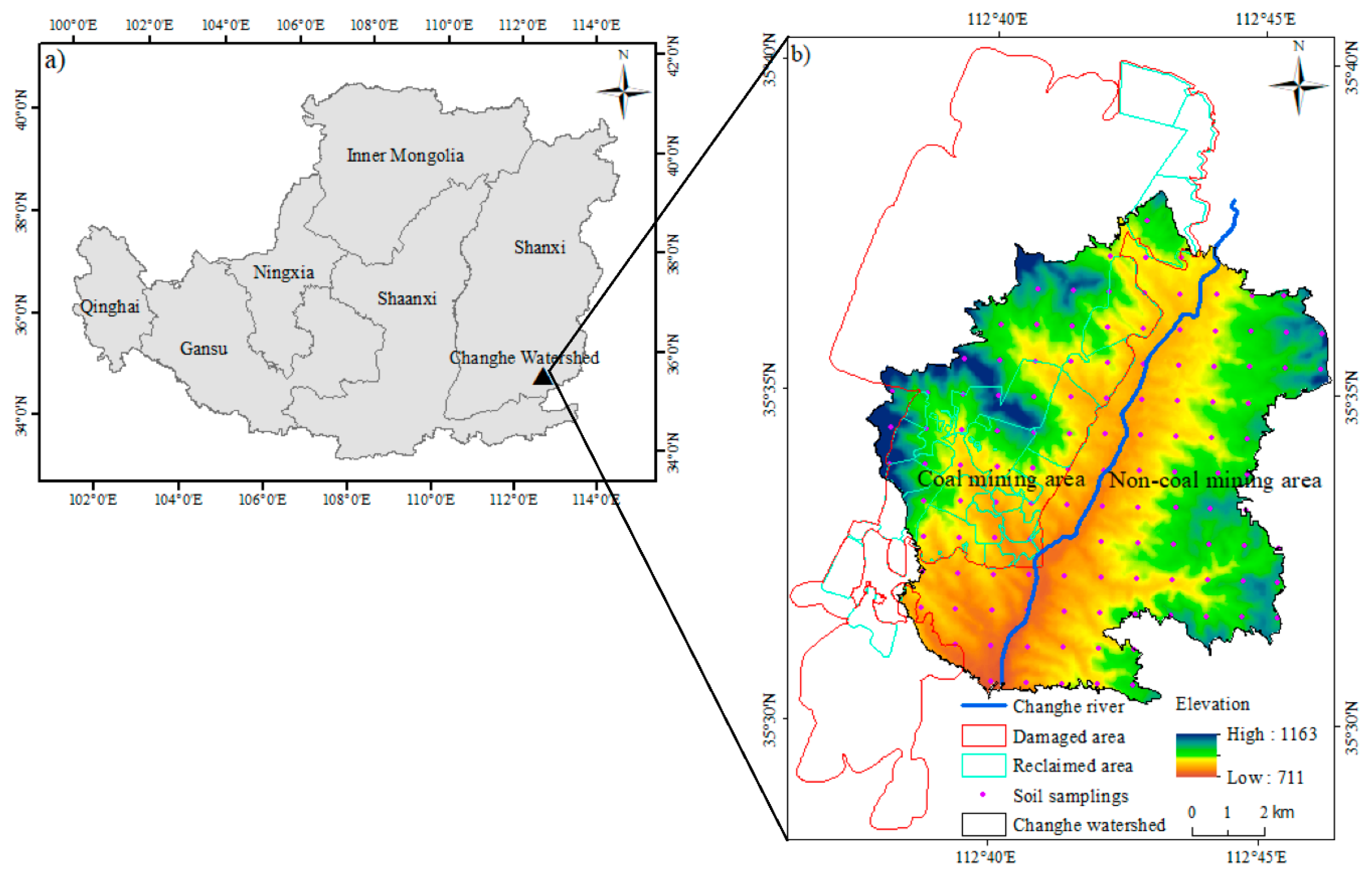
2.1. Study Area and Soil Sampling
2.2. Collection of Environmental Factors
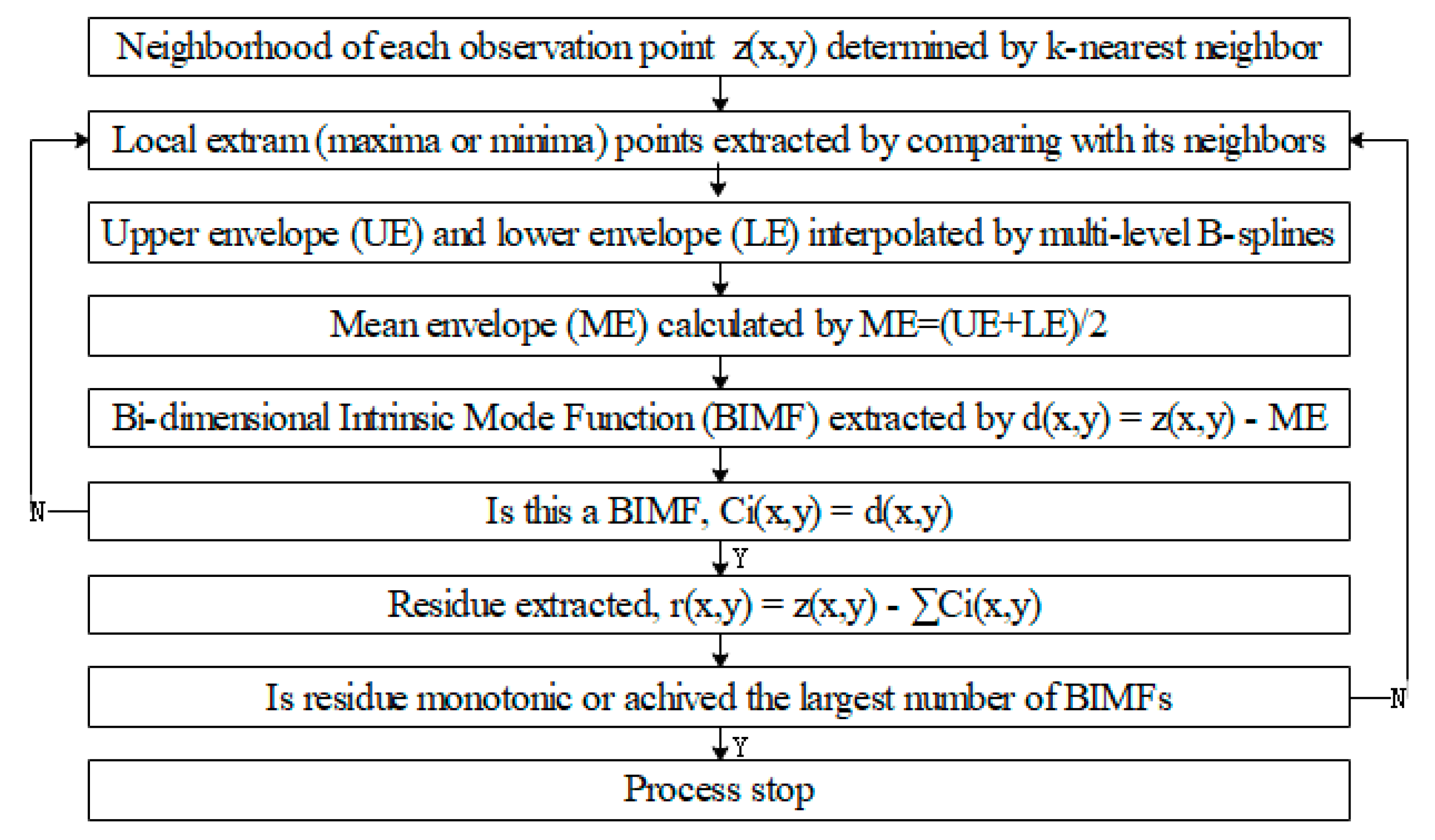
2.3. Two-Dimensional Empirical Mode Decomposition (2D-EMD)
2.4. Data Analysis
3. Results
3.1. Soil Properties at the Sampling Scale
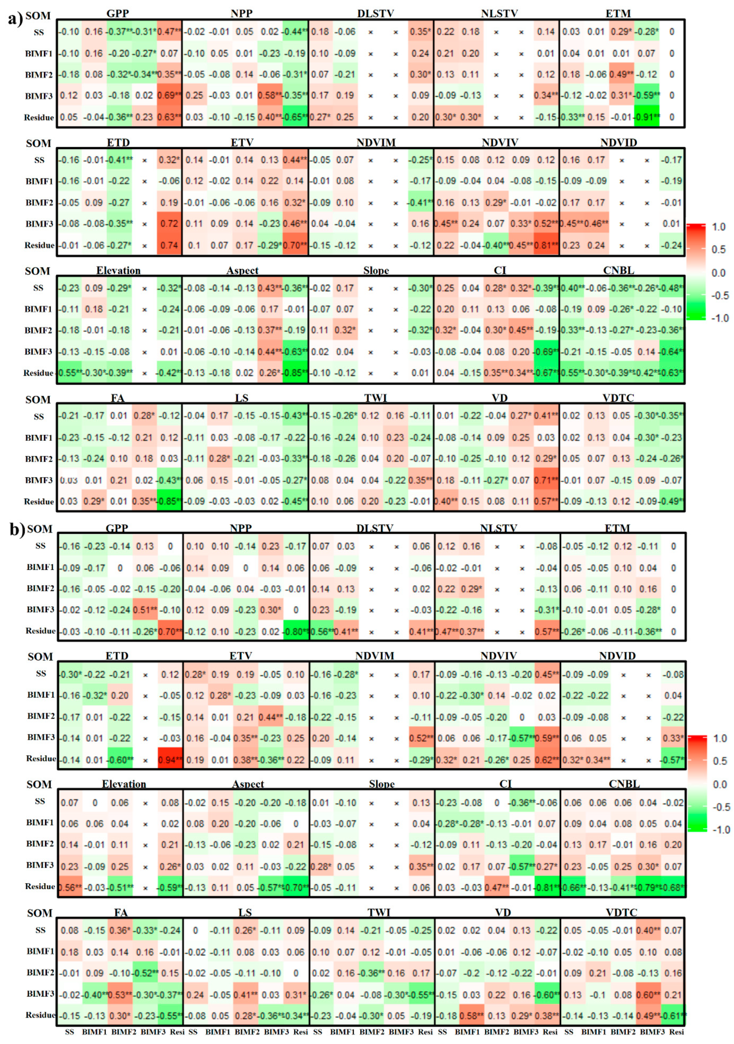
3.2. Scale-Specific Relationships of Soil Nutrients with Environmental Factors
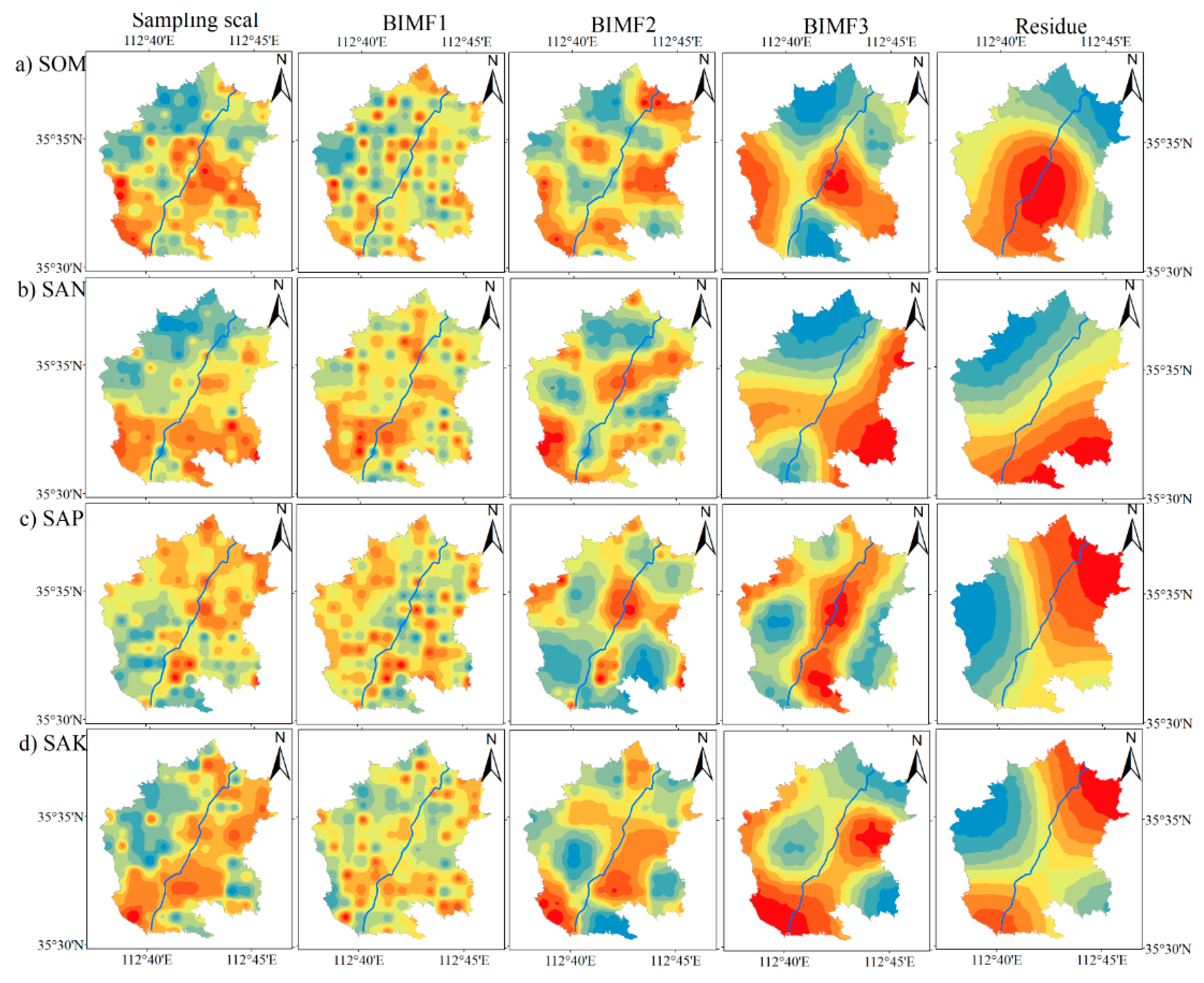
3.3. Soil Nutrient Prediction
4. Discussion
5. Conclusions
Author Contributions
Funding
Acknowledgments
Conflicts of Interest
References
- McBratney, A.B.; Mendonça Santos, L.M.; Minasny, B. On Digital Soil Mapping. Geoderma 2003, 117, 3–52. [Google Scholar] [CrossRef]
- Gong, G.; Mattevada, S.; O’Bryant, S.E. Comparison of the accuracy of kriging and IDW interpolations in estimating groundwater arsenic concentrations in Texas. Environ. Res. 2014, 130, 59–69. [Google Scholar] [CrossRef] [PubMed]
- Tang, X.; Xia, M.; Pérez-Cruzado, C.; Guan, F.; Fan, S. Spatial distribution of soil organic carbon stock in Moso bamboo forests in subtropical China. Sci. Rep. 2017, 7, 42640. [Google Scholar] [CrossRef] [PubMed]
- Zhang, Y.; Guo, L.; Chen, Y.; Shi, T.; Luo, M.; Ju, Q.; Zhang, H.; Wang, S. Prediction of Soil Organic Carbon based on Landsat 8 Monthly NDVI Data for the Jianghan Plain in Hubei Province, China. Remote Sens. 2019, 11, 1683. [Google Scholar] [CrossRef]
- Kumar, S.; Singh, R.P. Spatial distribution of soil nutrients in a watershed of Himalayan landscape using terrain attributes and geostatistical methods. Environ. Earth Sci. 2016, 75, 473. [Google Scholar] [CrossRef]
- Liu, Y.; Guo, L.; Jiang, Q.; Zhang, H.; Chen, Y. Comparing geospatial techniques to predict SOC stocks. Soil Tillage Res. 2015, 148, 46–58. [Google Scholar] [CrossRef]
- Malone, B.P.; Jha, S.K.; Minasny, B.; McBratney, A.B. Comparing regression-based digital soil mapping and multiple-point geostatistics for the spatial extrapolation of soil data. Geoderma 2016, 262, 243–253. [Google Scholar] [CrossRef]
- Angelopoulou, T.; Tziolas, N.; Balafoutis, A.; Zalidis, G.; Bochtis, D. Remote Sensing Techniques for Soil Organic Carbon Estimation: A Review. Remote Sens. 2019, 11, 676. [Google Scholar] [CrossRef]
- Nocita, M.; Stevens, A.; Wesemael, B.V.; Aitkenhead, M.; Bachmann, M.; Barthès, B.; Dor, E.B.; Brown, D.J.; Clairotte, M.; Csorba, A. Soil Spectroscopy: An Alternative to Wet Chemistry for Soil Monitoring; Advances in Agronomy; Elsevier: Cambridge, MA, USA, 2015; Volume 132, pp. 139–159. [Google Scholar]
- Zhu, H.; Xu, Z.; Jing, Y.; Bi, R.; Yang, W. Spatial variation and predictions of soil organic matter and total nitrogen based on VNIR reflectance in a basin of Chinese Loess Plateau. J. Soil Sci Plant Nutr. 2018, 18, 1126–1141. [Google Scholar] [CrossRef]
- Hu, W.; Chau, H.W.; Si, B.C. Vis-Near IR Spectroscopy for Soil Organic Carbon Content Measurement in the Canadian Prairies. CLEAN Soil Air Water 2015, 43, 1215–1223. [Google Scholar] [CrossRef]
- Schillaci, C.; Acutis, M.; Lombardo, L.; Lipani, A.; Fantappiè, M.; Märker, M.; Saia, S. Spatio-temporal topsoil organic carbon mapping of a semi-arid Mediterranean region: The role of land use, soil texture, topographic indices and the influence of remote sensing data to modelling. Sci. Total Environ. 2017, 601, 821–832. [Google Scholar] [CrossRef] [PubMed]
- Zhu, H.; Zhao, Y.; Nan, F.; Duan, Y.; Bi, R. Relative influence of soil chemistry and topography on soil available micronutrients by structural equation modeling. J. Soil Sci. Plant Nutr. 2016, 16, 1038–1051. [Google Scholar] [CrossRef]
- Zhu, H.; Wei, H.; Yaodong, J.; Yi, C.; Rutian, B.; Wude, Y. Soil organic carbon prediction based on scale-specific relationships with environmental factors by discrete wavelet transform. Geoderma 2018, 330, 9–18. [Google Scholar] [CrossRef]
- Hu, W.; Si, B.C. Soil water prediction based on its scale-specific control using multivariate empirical mode decomposition. Geoderma 2013, 193, 180–188. [Google Scholar] [CrossRef]
- Liu, E.; Liu, J.; Yu, K.; He, P.; Zhao, Z. Spatial Prediction of Forest Soil Organic Matter Based on Environmental Factors and R-STPS Interpolation Methods. Nongye Jixie Xuebao 2015, 46, 133–137. [Google Scholar] [CrossRef]
- Tajik, S.; Ayoubi, S.; Zeraatpisheh, M. Digital mapping of soil organic carbon using ensemble learning model in Mollisols of Hyrcanian forests, northern Iran. Geoderma Reg. 2020, 20, e00256–e00263. [Google Scholar] [CrossRef]
- Zhao, Z.; Yang, Q.; Sun, D.; Ding, X.; Meng, F.-R. Extended model prediction of high-resolution soil organic matter over a large area using limited number of field samples. Comput. Electron. Agric. 2020, 169, 105172. [Google Scholar] [CrossRef]
- Zhang, C.; Yang, Y. Can the spatial prediction of soil organic matter be improved by incorporating multiple regression confidence intervals as soft data into BME method? CATENA 2019, 178, 322–334. [Google Scholar] [CrossRef]
- Bourennane, H.; Salvador-Blanes, S.; Couturier, A.; Chartin, C.; Pasquier, C.; Hinschberger, F.; Macaire, J.-J.; Daroussin, J. Geostatistical approach for identifying scale-specific correlations between soil thickness and topographic attributes. Geomorphology 2014, 220, 58–67. [Google Scholar] [CrossRef]
- She, D.; Qian, C.; Timm, L.C.; Beskow, S.; Hu, W.; Leitzke Caldeira, T.; Montebello de Oliveira, L. Multi-scale correlations between soil hydraulic properties and associated factors along a Brazilian watershed transect. Geoderma 2017, 286, 15–24. [Google Scholar] [CrossRef]
- Zhu, H.; Cao, Y.; Jing, Y.; Liu, G.; Bi, R.; Yang, W. Multi-scale spatial relationships between soil total nitrogen and influencing factors in a basin landscape based on multivariate empirical mode decomposition. J. Arid Land 2019, 11, 385–399. [Google Scholar] [CrossRef]
- Xu, Z.; Zhang, Y.; Yang, J.; Liu, F.; Bi, R.; Zhu, H.; Lv, C.; Yu, J. Effect of Underground Coal Mining on the Regional Soil Organic Carbon Pool in Farmland in a Mining Subsidence Area. Sustainability 2019, 11, 4961. [Google Scholar] [CrossRef]
- Nachtergaele, F.; Van Velthuizen, H.; Verelst, L.; Batjes, N.; Dijkshoorn, K.; Van Engelen, V.; Fischer, G.; Jones, A.; Montanarella, L.; Petri, M. Harmonized World Soil Database; Food and Agriculture Organization of the United Nations: Rome, Italy, 2008. [Google Scholar]
- Nelson, D.W. Total Carbon, Organic Carbon and Organic Matter; ASA-SSSA: Madison, WI, USA, 1982; Volume 9, pp. 961–1010. [Google Scholar]
- Jackson, M.L. Soil Chemical Analysis: Advanced Course; UW-Madison Libraries Parallel Press: Madison, WI, USA, 2005. [Google Scholar]
- Olsen, S.R.; Cole, C.V.; Watanabe, F.S. Estimation of Available Phosphorus in Soils by Extraction with Sodium Bicarbonate; USDA: Washington, WA, USA, 1954. [Google Scholar]
- Isaac, E.; Kerber, J.D. Atomic Absorption and Flame Photometry: Techniques and Uses in Soil, Plant and Water Analysis; SSSA: Madison, WI, USA, 1972. [Google Scholar]
- Gee, G.W.; Bauder, J.W. Particle-size analysis. In Methods of Soil Analysis, Part 1. Physical and Mineralogical Methods, 2nd ed.; Klute, A., Ed.; The Agronomy Series; Elsevier: Madison, WI, USA, 1986; pp. 383–411. [Google Scholar]
- Schillaci, C.; Braun, A.; Kropáček, J. Terrain Analysis and Landform Recognition; British Society for Geomorphology: London, UK, 2015. [Google Scholar]
- Zhu, H.; Sun, R.; Bi, R.; Li, T.; Jing, Y.; Hu, W. Unraveling the local and structured variation of soil nutrients using two-dimensional empirical model decomposition in Fen River Watershed, China. Arch. Agron. Soil Sci. 2019, 1–14. [Google Scholar] [CrossRef]
- Huang, J.; Wu, C.; Minasny, B.; Roudier, P.; McBratney, A.B. Unravelling scale- and location-specific variations in soil properties using the 2-dimensional empirical mode decomposition. Geoderma 2017, 307, 139–149. [Google Scholar] [CrossRef]
- Xu, G.L.; Wang, X.T.; Xu, X.G. Improved bi-dimensional empirical mode decomposition based on 2D-assisted signals: Analysis and application. In IET Image Processing; Institution of Engineering and Technology: Stevenage, UK, 2011; Volume 5, pp. 205–221. [Google Scholar]
- Roudier, P. A Bi-Dimensional Implementation of the Empirical Mode Decomposition for Spatial Data. R Package Version 0.1-0. Available online: https://github.com/pierreroudier/spemd (accessed on 1 July 2018).
- Takeda, M.; Nakamoto, T.; Miyazawa, K. Phosphorus availability and soil biological activity in an Andosol under compost application and winter cover cropping. Appl. Soil Ecol. 2009, 42, 86–95. [Google Scholar] [CrossRef]
- Ma, K.; Zhang, Y.; Ruan, M.; Guo, J.; Chai, T. Land Subsidence in a Coal Mining Area Reduced Soil Fertility and Led to Soil Degradation in Arid and Semi-Arid Regions. IJERPH 2019, 16, 3929. [Google Scholar] [CrossRef]
- Sun, W.; Li, X.; Niu, B. Prediction of soil organic carbon in a coal mining area by Vis-NIR spectroscopy. PLoS ONE 2018, 13, e0196198. [Google Scholar] [CrossRef]
- Jing, Z.; Wang, J.; Zhu, Y.; Feng, Y. Effects of land subsidence resulted from coal mining on soil nutrient distributions in a loess area of China. J. Clean. Prod. 2018, 177, 350–361. [Google Scholar] [CrossRef]
- Hu, W.; Biswas, A.; Si, B. Application of multivariate empirical mode decomposition for revealing scale-and season-specific time stability of soil water storage. Catena 2014, 113, 377–385. [Google Scholar] [CrossRef]
- Zhou, Y.; Biswas, A.; Ma, Z.; Lu, Y.; Chen, Q.; Shi, Z. Revealing the scale-specific controls of soil organic matter at large scale in Northeast and North China Plain. Geoderma 2016, 271, 71–79. [Google Scholar] [CrossRef]
- Zhao, R.; Biswas, A.; Zhou, Y.; Zhou, Y.; Shi, Z.; Li, H. Identifying localized and scale-specific multivariate controls of soil organic matter variations using multiple wavelet coherence. Sci. Total Environ. 2018, 643, 548–558. [Google Scholar] [CrossRef] [PubMed]
- Si, B.C. Spatial scaling analyses of soil physical properties: A review of spectral and wavelet methods. Vadose Zone J. 2008, 7, 547–562. [Google Scholar] [CrossRef]


| Soil Nutrients | Areas | Min | Mean | Max | Std | CV | ANOVA | ||
|---|---|---|---|---|---|---|---|---|---|
| F | p-value | ||||||||
| SOM (g/kg) | Coal mining area | 1.10 | 17.42 | 36.42 | 7.79 | 44.73 | a | 4.04 | 0.04 |
| Non-coal mining area | 4.72 | 19.88 | 32.63 | 5.58 | 28.09 | b | |||
| SAN (mg/kg) | Coal mining area | 7.42 | 32.44 | 57.48 | 12.04 | 37.12 | a | 10.12 | 0.00 |
| Non-coal mining area | 5.56 | 39.40 | 66.75 | 11.92 | 30.26 | b | |||
| SAP (mg/kg) | Coal mining area | 0.95 | 7.95 | 16.91 | 3.83 | 48.15 | a | 2.60 | 0.11 |
| Non-coal mining area | 1.52 | 9.21 | 22.30 | 5.11 | 55.48 | a | |||
| SAK (mg/kg) | Coal mining area | 60.30 | 152.50 | 311.55 | 40.75 | 26.73 | a | 2.42 | 0.12 |
| Non-coal mining area | 70.35 | 163.14 | 244.55 | 33.83 | 20.74 | a | |||
| Sand (-) | Coal mining area | 0.09 | 0.23 | 0.64 | 0.09 | 40.06 | a | 4.94 | 0.03 |
| Non-coal mining area | 0.09 | 0.19 | 0.67 | 0.09 | 47.93 | b | |||
| Silt (-) | Coal mining area | 0.22 | 0.48 | 0.66 | 0.10 | 21.37 | a | 6.13 | 0.01 |
| Non-coal mining area | 0.18 | 0.52 | 0.70 | 0.10 | 18.56 | b | |||
| Clay (-) | Coal mining area | 0.14 | 0.29 | 0.48 | 0.08 | 26.98 | a | 0.19 | 0.67 |
| Non-coal mining area | 0.13 | 0.28 | 0.56 | 0.08 | 27.25 | a | |||
| Soil Texture | Coal Mining Area | Non-Coal Mining Area | The Entire Area | |||||||||
|---|---|---|---|---|---|---|---|---|---|---|---|---|
| SOM | SAN | SAP | SAK | SOM | SAN | SAP | SAK | SOM | SAN | SAP | SAK | |
| Sand | −0.10 | −0.07 | −0.01 | −0.32 * | 0.01 | 0.08 | −0.06 | −0.44 ** | −0.09 | −0.05 | −0.07 | −0.39 ** |
| Silt | 0.27 * | 0.34 ** | −0.12 | 0.32 * | −0.23 | −0.10 | −0.15 | 0.16 | 0.10 | 0.18 * | 0.10 | 0.27 ** |
| Clay | −0.22 | −0.37 ** | 0.20 | −0.07 | 0.29 * | 0.03 | 0.26 * | 0.32 * | 0.02 | 0.18 | 0.22 * | 0.09 |
| Soil Nutrients | Area | BIMF1 | BIMF2 | BIMF3 | Residue | SV |
|---|---|---|---|---|---|---|
| SOM | Coal mining area | 53.59 | 24.24 | 19.47 | 6.82 | 50.53 |
| Non-coal mining area | 57.08 | 19.92 | 13.88 | 6.24 | 40.04 | |
| SAN | Coal mining area | 55.57 | 17.99 | 12.15 | 7.17 | 37.31 |
| Non-coal mining area | 58.59 | 15.11 | 9.06 | 10.42 | 34.59 | |
| SAP | The entire area | 73.60 | 19.19 | 1.05 | 11.44 | 31.68 |
| SAK | The entire area | 64.48 | 20.24 | 4.80 | 5.65 | 30.69 |
| Soil Nutrients | Methods | Calibration Accuracy | Validation Accuracy | ||||
|---|---|---|---|---|---|---|---|
| R2 | RMSE | RPD | R2 | RMSE | RPD | ||
| SOM in coal mining area | MLSROri | 0.66 ** | 4.86 | 1.72 | 0.08 | 29.20 | 0.21 |
| PLSROri | 0.31 ** | 6.85 | 1.22 | 0.28 * | 5.05 | 1.19 | |
| PLSRBIMF | 0.55 ** | 5.59 | 1.50 | 0.20 * | 6.45 | 0.93 | |
| 2D-EMDPM | 0.62 ** | 5.08 | 1.64 | 0.64 ** | 4.23 | 1.42 | |
| SOM in non-coal mining area | MLSROri | 0.52 ** | 3.75 | 1.45 | 0.02 | 59.50 | 0.10 |
| PLSROri | 0.24 ** | 4.68 | 1.16 | 0.12 | 5.82 | 0.98 | |
| PLSRBIMF | 0.18 ** | 2.92 | 1.87 | 0.32 * | 5.30 | 1.08 | |
| 2D-EMDPM | 0.48 ** | 3.95 | 1.38 | 0.57 ** | 4.11 | 1.39 | |
| SAN in coal mining area | MLSROri | 0.62 ** | 7.42 | 1.66 | 0.00 | 46.72 | 0.25 |
| PLSROri | 0.49 ** | 8.65 | 1.42 | 0.26 | 9.79 | 1.20 | |
| PLSRBIMF | 0.71 ** | 6.51 | 1.89 | 0.45 ** | 8.95 | 1.31 | |
| 2D-EMDPM | 0.70 ** | 6.68 | 1.84 | 0.61 ** | 7.30 | 1.60 | |
| SAN in non-coal mining area | MLSROri | 0.71 ** | 6.90 | 1.86 | 0.21 | 164.81 | 0.06 |
| PLSROri | 0.32 ** | 10.45 | 1.23 | 0.30 * | 8.49 | 1.07 | |
| PLSRBIMF | 0.71 ** | 6.87 | 1.87 | 0.19 * | 9.38 | 0.97 | |
| 2D-EMDPM | 0.43 ** | 9.52 | 1.34 | 0.40 ** | 7.27 | 1.25 | |
| SAP in the entire area | MLSROri | 0.23 ** | 4.22 | 1.15 | 0.01 | 23.23 | 0.16 |
| PLSROri | 0.10 ** | 4.58 | 1.06 | 0.07 | 3.56 | 1.01 | |
| PLSRBIMF | 0.31 ** | 4.00 | 1.21 | 0.14 * | 4.18 | 0.86 | |
| 2D-EMDPM | 0.23 ** | 4.22 | 1.15 | 0.15 * | 3.43 | 1.05 | |
| SAK in the entire area | MLSROri | 0.34 ** | 31.40 | 1.23 | 0.00 | 137.59 | 0.25 |
| PLSROri | 0.26 ** | 33.21 | 1.17 | 0.01 | 40.06 | 0.86 | |
| PLSRBIMF | 0.46 ** | 28.34 | 1.37 | 0.06 | 38.33 | 0.90 | |
| 2D-EMDPM | 0.34 ** | 31.40 | 1.23 | 0.20 * | 33.02 | 1.05 | |
| Soil Nutrients | Procedure | LVs | Calibration Accuracy | Validation Accuracy | ||||
|---|---|---|---|---|---|---|---|---|
| R2 | RMSE | RPD | R2 | RMSE | RPD | |||
| SOM in coal mining area | BIMF1 (PLSR) | 3 | 0.12 * | 5.65 | 1.05 | 0.13 | 5.45 | 1.09 |
| BIMF2 (PLSR) | 22 | 0.95 ** | 0.69 | 4.51 | 0.64 ** | 2.02 | 1.35 | |
| BIMF3 (PLSR) | 23 | 0.99 ** | 0.21 | 10.69 | 0.87 ** | 0.96 | 2.71 | |
| Residue (PLSR) | 41 | 1.00 ** | 0.00 | 1496.61 | 1.00 ** | 0.06 | 18.04 | |
| SOM (MLSR) | - | 0.62 ** | 5.08 | 1.64 | 0.64 ** | 4.23 | 1.42 | |
| −6.31 + 1.64 IMF2’ + 0.83 IMF3’ + 1.33 Residue’ | ||||||||
| SOM in non-coal mining area | BIMF1 (PLSR) | 2 | 0.11 | 4.29 | 0.98 | 0.16 | 3.76 | 0.80 |
| BIMF2 (PLSR) | 15 | 0.81 ** | 1.20 | 2.29 | 0.39 ** | 2.45 | 1.16 | |
| BIMF3 (PLSR) | 38 | 1.00 ** | 0.05 | 47.47 | 0.78 ** | 1.44 | 1.70 | |
| Residue (PLSR) | 35 | 1.00 ** | 0.01 | 175.19 | 0.99 ** | 0.15 | 9.48 | |
| SOM (MLSR) | - | 0.48 ** | 3.95 | 1.38 | 0.57 ** | 4.11 | 1.39 | |
| 2.39 + 0.95 IMF2’ + 0.87 IMF3’ + 0.87 Residue’ | ||||||||
| SAN in coal mining area | BIMF1 (PLSR) | 1 | 0.09 * | 8.09 | 1.06 | 0.04 | 7.39 | 1.04 |
| BIMF2 (PLSR) | 18 | 0.94 ** | 4.02 | 1.10 | 0.65 ** | 4.11 | 1.18 | |
| BIMF3 (PLSR) | 40 | 1.00 ** | 0.01 | 657.15 | 0.98 ** | 0.54 | 14.17 | |
| Residue (PLSR) | 42 | 1.00 ** | 0.00 | 5327.92 | 0.99 ** | 0.20 | 9.83 | |
| SAN (MLSR) | - | 0.70 ** | 6.68 | 1.84 | 0.61 ** | 7.30 | 1.60 | |
| −3.09 + 0.44 IMF2’ + 1.36 IMF3’ + 2.69 Residue’ | ||||||||
| SAN in non-coal mining area | BIMF1 (PLSR) | 1 | 0.03 | 9.64 | 1.02 | 0.41 ** | 7.53 | 0.86 |
| BIMF2 (PLSR) | 20 | 0.87 ** | 1.55 | 2.81 | 0.35 ** | 5.03 | 0.87 | |
| BIMF3 (PLSR) | 40 | 1.00 ** | 0.00 | 1024.42 | 0.92 ** | 3.70 | 0.96 | |
| Residue (PLSR) | 41 | 1.00 ** | 0.00 | 1742.53 | 1.00 ** | 0.27 | 13.76 | |
| SAN (MLSR) | - | 0.43 ** | 9.52 | 1.34 | 0.40 ** | 7.27 | 1.25 | |
| −0.11 + 0.87 IMF2’ + 1.74 IMF3’ + 0.92 Residue’ | ||||||||
| SAP in the entire area | BIMF1 (PLSR) | 1 | 0.02 | 4.01 | 1.02 | 0.02 | 6.55 | 0.30 |
| BIMF2 (PLSR) | 52 | 0.95 ** | 0.45 | 4.40 | 0.50 ** | 2.55 | 1.27 | |
| BIMF3 (PLSR) | 59 | 0.99 ** | 0.04 | 11.08 | 0.66 ** | 0.28 | 1.60 | |
| Residue (PLSR) | 61 | 1.00 ** | 0.01 | 166.18 | 0.99 ** | 0.13 | 11.65 | |
| SAP (MLSR) | - | 0.23 ** | 4.22 | 1.15 | 0.15 * | 3.43 | 1.05 | |
| 1.88 + 0.88 IMF2’ + 0.96 IMF3’ + 0.78 Residue’ | ||||||||
| SAK in the entire area | BIMF1 (PLSR) | 52 | 0.69 ** | 17.39 | 1.80 | 0.01 | 103.53 | 0.26 |
| BIMF2 (PLSR) | 52 | 0.95 ** | 3.66 | 4.61 | 0.56 ** | 13.83 | 1.30 | |
| BIMF3 (PLSR) | 54 | 1.00 ** | 0.31 | 25.56 | 0.98 ** | 1.32 | 6.92 | |
| Residue (PLSR) | 52 | 1.00 ** | 0.12 | 73.98 | 0.99 ** | 0.77 | 11.75 | |
| SAK (MLSR) | - | 0.34 ** | 31.40 | 1.23 | 0.20 * | 33.02 | 1.05 | |
| −27.27 + 0.96 IMF2’ + 0.60 IMF3’ + 1.16 Residue’ | ||||||||
© 2020 by the authors. Licensee MDPI, Basel, Switzerland. This article is an open access article distributed under the terms and conditions of the Creative Commons Attribution (CC BY) license (http://creativecommons.org/licenses/by/4.0/).
Share and Cite
Zhu, H.; Sun, R.; Xu, Z.; Lv, C.; Bi, R. Prediction of Soil Nutrients Based on Topographic Factors and Remote Sensing Index in a Coal Mining Area, China. Sustainability 2020, 12, 1626. https://doi.org/10.3390/su12041626
Zhu H, Sun R, Xu Z, Lv C, Bi R. Prediction of Soil Nutrients Based on Topographic Factors and Remote Sensing Index in a Coal Mining Area, China. Sustainability. 2020; 12(4):1626. https://doi.org/10.3390/su12041626
Chicago/Turabian StyleZhu, Hongfen, Ruipeng Sun, Zhanjun Xu, Chunjuan Lv, and Rutian Bi. 2020. "Prediction of Soil Nutrients Based on Topographic Factors and Remote Sensing Index in a Coal Mining Area, China" Sustainability 12, no. 4: 1626. https://doi.org/10.3390/su12041626
APA StyleZhu, H., Sun, R., Xu, Z., Lv, C., & Bi, R. (2020). Prediction of Soil Nutrients Based on Topographic Factors and Remote Sensing Index in a Coal Mining Area, China. Sustainability, 12(4), 1626. https://doi.org/10.3390/su12041626