A Spatiotemporal Assessment of Land Use and Land Cover Changes in Peri-Urban Areas: A Case Study of Arshaly District, Kazakhstan
Abstract
1. Introduction
2. Materials and Methods
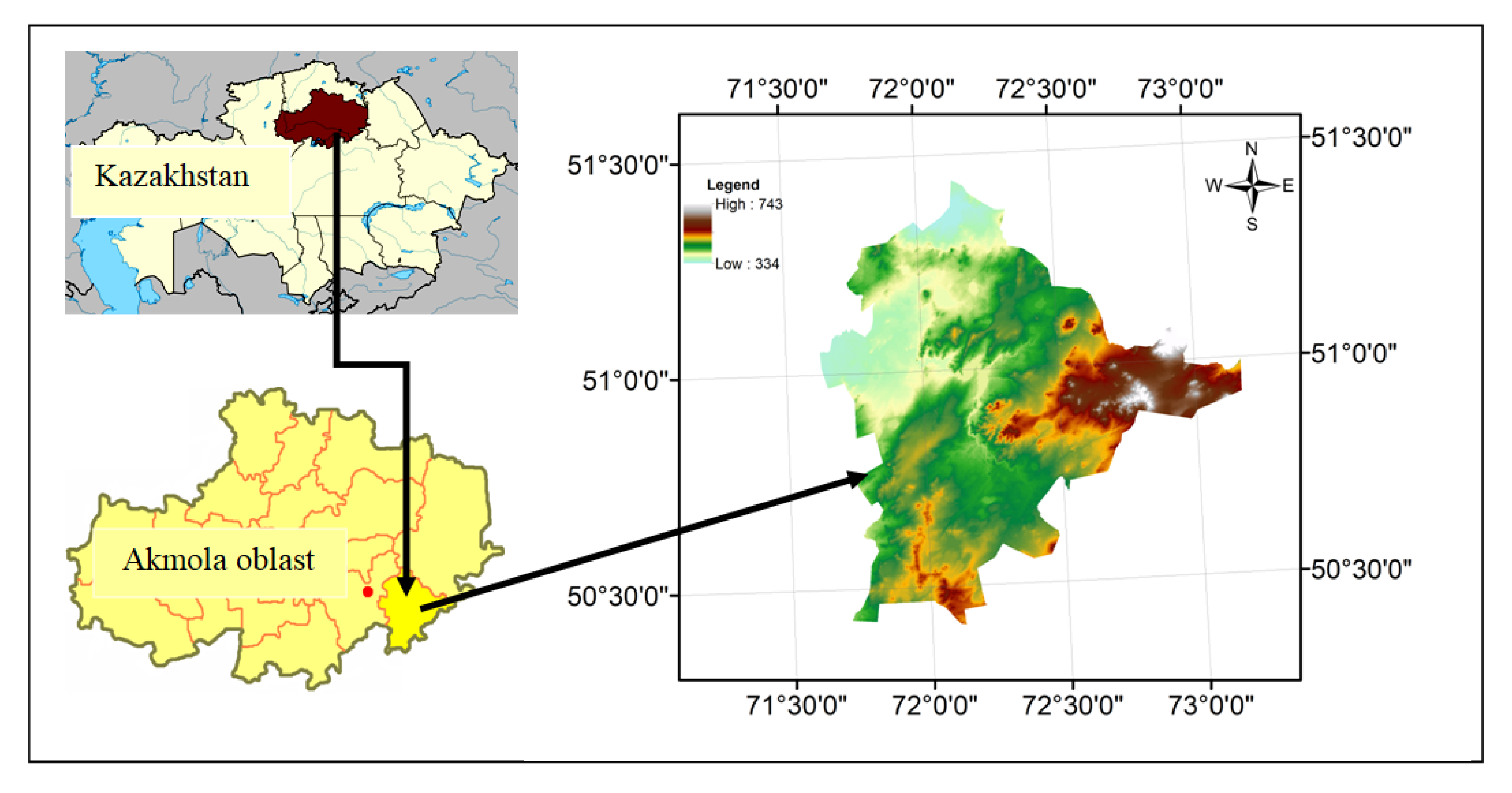
2.1. Study Area
2.2. Data
2.3. Ancillary Data
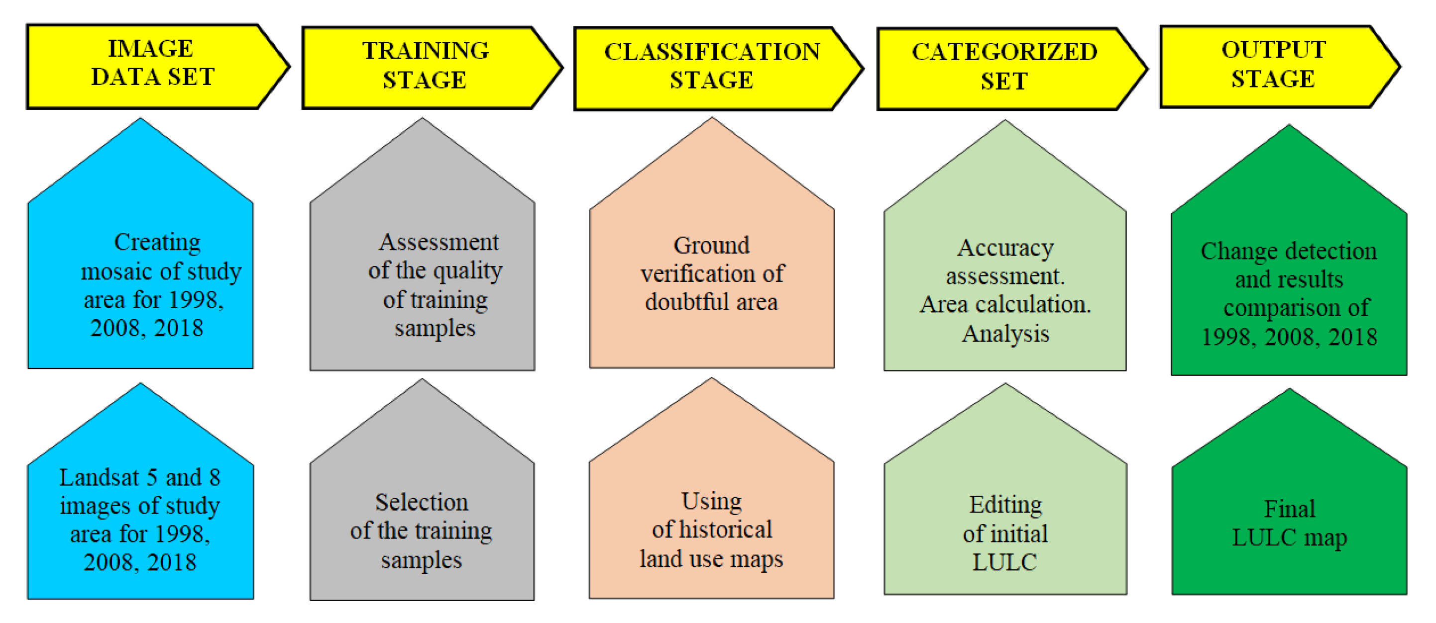
2.4. Methods for Classifying and Accuracy Assessment
3. Results
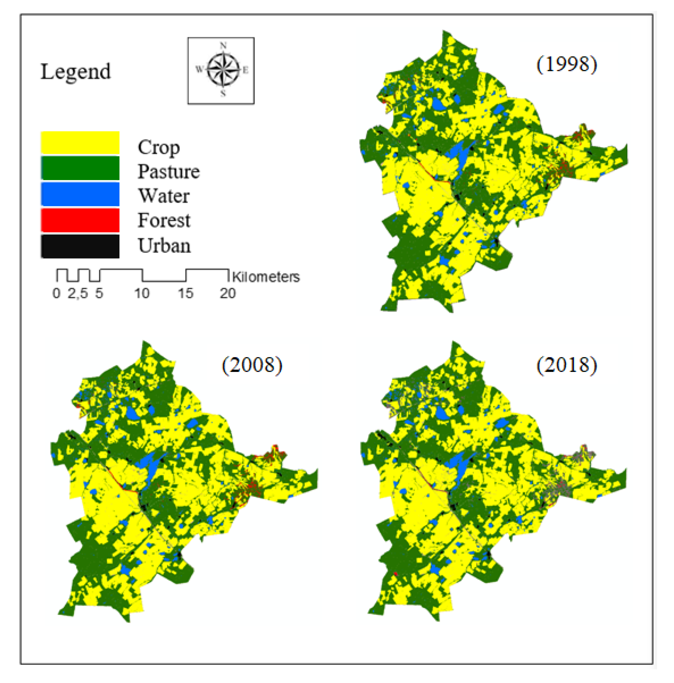
3.1. Overall LULC Changes
3.2. Classification Accuracy
4. Discussion
4.1. Urban Sprawl and Population Growth
4.2. Peri-Urban Area
4.3. Accessibility
4.4. Economic and Legal Factors
5. Conclusions
Author Contributions
Funding
Conflicts of Interest
References and Notes
- Urban Sprawl in Europe Joint EEA-FOEN Report. 2016, Volume 11, p. 140. Available online: https://www.eea.europa.eu/publications/urban-sprawl-in-europe (accessed on 7 January 2020).
- Goswami, M. Conceptualizing Peri-Urban-Rural Landscape Change for Sustainable Management. Available online: http://www.isec.ac.in/WP%20425%20-%20Mrinalini%20Goswami%20-%20Final.pdf (accessed on 10 January 2020).
- Jiang, L.; Deng, X.; Seto, K. The Impact of Urban Expansion on Agricultural Land Use Intensity in China. Land Use Policy. 2013, 35, 33–39. [Google Scholar] [CrossRef]
- Tabuchi, T. Agglomeration in World Cities. ProcediaSoc. Behav. Sci. 2013, 77, 299–307. [Google Scholar] [CrossRef]
- Nur-Sultan City Akimat. Available online: http://astana.gov.kz/en/ (accessed on 3 January 2020).
- Alipbeki, O.; Alipbekova, C. Development of Spatial Data Infrastructure of Agroindustrial Agglomeration. In Proceedings of the International Conference on GIS and Remote Sensing in Agriculture, Copenhagen, Denmark, 11–12 June 2019; p. 761. [Google Scholar]
- Suleimenov, M. Trends in the Agriculture of Central Asia and Implications for Rangelands and Croplands. In Novel Measurements and Assessment Tools for Monitoring and Management of Land and Water Resources in Agricultural Landscapes of Central Asia; Environmental Science and Engineering, Springer: Switzerland, 2014; Volume XIII, pp. 91–105. Available online: https://www.springer.com/gp/book/9783319010168 (accessed on 18 February 2020).
- Dadras, M.; Shafri, Z.H.M.; Ahmad, N.; Pradhan, P.; Safarpour, S. Land Use/Cover Change Detection and Urban Sprawl Analysis in Bandar Abbas City, Iran. Sci. World J. 2014, 690872. Available online: https://www.ncbi.nlm.nih.gov/pmc/articles/PMC4167654/ (accessed on 18 February 2020). [CrossRef] [PubMed]
- Doygun, H. Effects of urban sprawl on agricultural land: A case study of KahramanmaraAY, Turkey. Environ. Monit. Assess 2008. [Google Scholar] [CrossRef] [PubMed]
- Mulugeta, M.; Tesfaye, B.; Ayano, A. Data on Spatiotemporal Land Use Land Cover Changes in Peri-Urban Addis Ababa, Ethiopia: Empirical Evidences from Koye-Feche and Qilinto Peri-Urban Areas. Data Brief. 2017, 12, 380–385. [Google Scholar] [CrossRef] [PubMed]
- Mundhe, N.; Jaybhaye, R. Impact of urbanization on land use/land covers change using Geo-spatial techniques. Int. J. Geomat. Geosci. 2014, 5, 50–60. [Google Scholar]
- Hu, Y.; Kong, X.; Zheng, J.; Sun, J.; Wang, L.; Min, M. Urban Expansion and Farmland Loss in Beijing during 1980–2015. Sustainability 2018, 10, 3927. [Google Scholar] [CrossRef]
- Lutzenberger, A.; Brillinger, M.; Pott, S. Global Land-Use Analysis. LeuphanaUniversitätLüneburg, Institute for Sustainable and Environmental Chemistry. Available online: https://globalands.ecologic.eu/sites/default/files/Land%20Use%20Analysis%20final%20en.pdf (accessed on 18 February 2020).
- Manakos, I.; Braun, M. Land Use and Land Cover Mapping in Europe: Practices & Trends; Springer: New York, NY, USA, 2014; p. 441. [Google Scholar]
- Antrop, M. Land Use Changes Affected By Urban and Industrial Development. Land use, land cover and soil sciences. Encycl. Life Support Syst. 2009, 1, 169–183. [Google Scholar]
- Mbau, J.; Nyangio, M.; Gachene, C. Land Use and Land Cover Change Analysis: Linking Local Communities to Land Use and Land Cover Changes Using Participatory Geographic Information Systems (PGIS). Lambert; Academic Publishing: Cambridge, MA, USA, 2013; p. 96. [Google Scholar]
- Diogo, V.; Koomen, E. Land Cover and Land Use Indicators: Review of Available Data. OECD Green Growth Papers. 2017. Available online: https://www.researchgate.net/publication/320064438_Land_Cover_and_Land_Use_Indicators_Review_of_available_data (accessed on 18 February 2020).
- Diao, X.; Magalhaes, E.; Silver, J. Cities and rural transformation: A spatial analysis of rural livelihoods in Ghana. World Dev. 2019, 121, 141–157. [Google Scholar] [CrossRef]
- Samuel, D.; Leke, O.; Immaculata, N. Urban Sprawl and Loss of Agricultural Land in Peri-urban Areas of Lagos. Reg. Stat. 2016, 5, 20–33. [Google Scholar] [CrossRef]
- Wu, Y.; Wang, H.; Wang, Z.; Zhang, B.; Burghard, C.; Meye, B.C. Knowledge Mapping Analysis of Rural Landscape Using Cite Space. Sustainability 2020, 12, 66. [Google Scholar] [CrossRef]
- Juliev, M.; Pulatov, A.; Fuchs, S.; Hübl, J. Analysis of Land Use Land Cover Change Detection of Bostanlik District, Uzbekistan. Pol. J. Environ. Stud. 2019, 28, 3235–3242. [Google Scholar] [CrossRef]
- Hu, Y.; Hu, Y. Land Cover Changes and Their Driving Mechanisms in Central Asia from 2001 to 2017 Supported by Google Earth Engine. Remote Sens. 2019, 11, 554. [Google Scholar] [CrossRef]
- Chen, Q.; Li, Y.; Liu, C.; Yang, Y.; Wu, J.; Li, M. Spatio-Temporal Variation in Mountainous Landscape Changes: A Case Study of Shizhu County. Sustainability 2019, 11, 2131. [Google Scholar] [CrossRef]
- Nath, B.; Niu, Z.; Singh, R.P. Land Use and Land Cover Changes, and Environment and Risk Evaluation of Dujiangyan City (SW China) Using Remote Sensing and GIS Techniques. Sustainability 2018, 10, 4631. [Google Scholar] [CrossRef]
- Enoguanbhor, E.C.; Gollnow, F.; Nielsen, J.O.; Lakes, T.; Walker, B.B. Land Cover Change in the Abuja City-Region, Nigeria: Integrating GIS and Remotely Sensed Data to Support Land Use Planning. Sustainability 2019, 11, 1313. (In Russia) [Google Scholar] [CrossRef]
- Sultangazin Umirzak Makhmutovich. Selected Works 1996-2006; Space Research Institute: Almaty, Kazakhstan, 2006; p. 420. (In Russia) [Google Scholar]
- Zakarin, E.A.; Mirkarimova, B.M.; Dedova, T.V. Geoinformation Models of Atmospheric Pollution of the Aral-Caspian Region of Kazakhstan; CaTa: Almaty, Kazakhstan, 2007; 108p. (In Russia) [Google Scholar]
- Kazakhstan Space Research. Space research and experiments of the Republic of Kazakhstan (2005–2007); LLP Dyke-Press: Almaty, Kazakhstan, 2008; Volume 2, p. 240. (In Russia) [Google Scholar]
- Kazakhstan Space Research. Applied Space Research in Kazakhstan; Musabaev, T., Zhantayev, Z., Eds.; LLP Dyke-Press: Almaty, Kazakhstan, 2010; Volume 6, p. 368. (In Russia) [Google Scholar]
- Akhmedov, D.S.; Zhantaev, Z.S.; Moldabekov, M.M.; Muratova, N.R.; Musabaev, T.A.; Spivak, L.F.; Sultangazin, U.M. Fundamental and Applied Research on the Development and Implementation of Modern Space Technologies in the Interests of Socio-Economic Development of the Republic of Kazakhstan for 1994–2009; Zhantayev, Z.S., Ed.; Triumph "T": Almaty, Kazakhstan, 2011; p. 160. (In Russia) [Google Scholar]
- Alipbeki, O.; Kabzhanova, G.; Kurmanova, G.; Alipbekova, C. Application of GIS Technology to Monitor the Secondary Radioactive Contamination of the Degelen Mountain Massif. In Proceedings of the 8th IGRSM International Conference and Exhibition on Geospatial and Remote Sensing, Kuala Lumpur, Malaysia, 13–14 April 2016; Available online: //http://iopscience.iop.org/article/10.1088/1755-1315/37/1/012080/meta (accessed on 18 February 2020).
- Alipbeki, O.; Kabzhanova, G.; Alipbekova, C. Carrying out space monitoring of agricultural production in North Kazakhstan. Eurasian Union Sci. 2016, 23, 153–156. [Google Scholar]
- KGS. Available online: https://www.gharysh.kz/AboutKA_DZZ/ (accessed on 18 February 2020).
- Kabzhanova, G.; Baktybekov, K.; Aimbetov, A.; Kurmasheva, A.; Kabdulova, G. Remote Monitoring of the Main Types of Soil in Northern Kazakhstan. Seventh International Conference on Remote Sensing and Geoinformation of the Environment. 27 June 2019. Available online: https://www.spiedigitallibrary.org/conference-proceedings-of-spie/11174/111740Q/Remote-monitoring-of-the-main-types-of-soil-in-Northern/10.1117/12.2533057.short?SSO=1 (accessed on 18 February 2020).
- Kabdulova, G.; Kabzhanova, G.; Baktybekov, K.; Aimbetov, A.; Aligazhiyeva, L. Satellite Remote Sensing for Monitoring of the Forest Resources of Kazakhstan. Seventh International Conference on Remote Sensing and Geoinformation of the Environment. 27 June 2019. Available online: https://www.spiedigitallibrary.org/conference-proceedings-of-spie/11174/1117406/Satellite-remote-sensing-for-monitoring-of-the-forest-resources-of/10.1117/12.2533563.short (accessed on 18 February 2020).
- Hamidov, A.; Helming, K.; Balla, D. Impact of Agricultural Land Use in Central Asia: A Review. Available online: https://link.springer.com/article/10.1007/s13593-015-0337-7 (accessed on 18 February 2020).
- Samarkhanov, K.; Abuduwaili, J.; Samat, A.; Issanova, G. The Spatial and Temporal Land Cover Patterns of the Qazaly Irrigation Zone in 2003–2018: The Case of Syrdarya River’s Lower Reaches, Kazakhstan. Sustainability 2019, 11, 4035. [Google Scholar] [CrossRef]
- Kraemer, R.; Prishchepov, A.V.; Müller, D.; Kuemmerle, T.; Radelof, V.C.; Dara, A.; Terekhov, A.; Frühauf, M. Long-term agricultural land-cover change and potential for cropland expansion in the former Virgin Lands area of Kazakhstan. Environ. Res. Lett. 2015, 10, 054012. [Google Scholar] [CrossRef]
- Eisfelder, C.; Markus Niklaus, M.; Kuenzer, C. Net primary productivity in Kazakhstan, its spatio-temporal patterns and relation to meteorological variables. J. Arid Environ. 2014, 103, 17–30. [Google Scholar] [CrossRef]
- Taibassarova, Z. Nazarbayev Detection of the Vegetation Change Cover Using Landsat TM5 in the Burabay State National Natural Park, Kazakhstan. Nazarbayev University, Astana. Available online: https://nur.nu.edu.kz/bitstream/handle/123456789/3190/Taibassarova.PDF?sequence=1&isAllowed=y (accessed on 18 February 2020).
- Ilyassova, A.; Kantakumar, N.L.; Boyd, D. Urban growth analysis and simulations using cellular automata and geo-informatics: Comparison between Almaty and Astana in Kazakhstan. Geocarto Int. 2019. [Google Scholar] [CrossRef]
- SRTM Data. Available online: http://srtm.csi.cgiar.org/ (accessed on 15 October 2019).
- Arshaly District. National Encyclopedia; Kazakh Encyclopedia: Almaty, Kazakhstan, 2004; Volume1, p. 720. (In Russia) [Google Scholar]
- Arshaly District Akmola Oblast. Available online: http://arshaly.akmo.gov.kz/ (accessed on 12 January 2020).
- United States Geological Survey. Available online: https://earthexplorer.usgs.gov/ (accessed on 18 February 2020).
- Automated Information System of the State Land Cadastre and Technical Support. Available online: http://www.aisgzk.kz/aisgzk/en/content/maps/ (accessed on 18 February 2020).
- National Cartographic and Geodesic Fund. Available online: http://nkgf.kz/ (accessed on 18 February 2020).
- Bossard, M.; Feranec, J.; Otahel, J. CORINE Land Cover Technical Guide-Addendum. 2000. Technical Report No. 40/2000. Copenhagen. Available online: https://www.eea.europa.eu/publications/tech40add (accessed on 9 January 2020).
- Kaul, H.A.; Sopan, I.T. Land Use Land Cover Classification and Change Detection Using High-Resolution Temporal Satellite Data. J. Environ. 2012, 1, 146–152. [Google Scholar]
- Nguyen, T.B.P.; Zhang, X.; Wu, W.; Liu, H. Land Use/Land Cover Changes from 1995 to 2017 in Trang Bang, Southern Vietnam. Agric. Sci. 2019, 10, 413–422. [Google Scholar] [CrossRef][Green Version]
- Lurie, I.K.; Kosikov, A.G. Theory and Practice of Digital Image Processing; Berlyant, A.M., Ed.; Scientific World: Moscow, Russia, 2003; p. 168. [Google Scholar]
- USGS EROS Archive-Land Cover Products-Global Land Cover Characterization (GLCC). Available online: https://www.usgs.gov/centers/eros/science/usgs-eros-archive-land-cover-products-global-land-cover-characterization-glcc?qt-science_center_objects=0#qt-science_center_objects (accessed on 18 February 2020).
- CORINE Land Cover. Available online: https://land.copernicus.eu/pan-european (accessed on 18 February 2020).
- Land Use Land Cover Change (LUCC) Data Set. Available online: http://chinaarchive.tamu.edu/portal/site/chinaarchive/menuitem.3da14c46c63d9737b5c923d7f00011ca/index.html (accessed on 18 February 2020).
- Charmes, E. Peri-Urbanisation is not Urban Sprawl. October 2015. Available online: http://www.citego.org/bdf_dossier-7_en.html (accessed on 18 February 2020).
- Urbanization, Rural Transformation and Implications for Food Security. Online Consultation on the Background Document to the CFS Forum. Available online: http://www.fao.org/3/a-bl630e.pdf (accessed on 18 February 2020).
- Li, J.; Yang, Y.; Jiang, N. County-Rural Transformation Development from Viewpoint of Population-Land-Industry in Beijing-Tianjin-Hebei Region under the Background of Rapid Urbanization. Sustainability 2017, 9, 1637. [Google Scholar] [CrossRef]
- Miljkovic, J.Z.; Crncevic, T.; Maric, I. Land Use Planning for Sustainable Development of Peri-Urban Zones. SPATIUM International Review. Available online: https://core.ac.uk/download/pdf/27229663.pdf (accessed on 18 February 2020).
- World Urbanization Prospects: The 2018 Revision. United Nations, Department of Economic and Social Affairs, Population Division. Available online: https://population.un.org/wup/Publications/Files/WUP2018-Report.pdf (accessed on 18 February 2020).
- Krannich, J.M. A Modern Disaster: Agricultural Land, Urban Growth, and the Need for a Federally Organized Comprehensive Land Use Planning Model. Cornell J. Law Public Policy 2006, 16, 45. [Google Scholar]
- National Report of the Republic of Kazakhstan on Housing and Sustainable Urban Development. Available online: http://habitat3.org/wp-content/uploads/National-Report-of-the-Republic-of-Kazakhstan-Russian-%D0%86%D0%86%D0%86.pdf (accessed on 18 February 2020).
- The Dynamics of the Development of Astana for 18 Years. Available online: https://www.inform.kz/ru/dinamika-razvitiya-astany-za-18-let_a2927630 (accessed on 18 February 2020).
- Which Territories Joined Astana. Available online: https://www.zakon.kz/4843303-kakie-territorii-prisoedinili-k-astane.html (accessed on 18 February 2020).
- The Population of Nur-Sultan. Available online: https://ru.wikipedia.org/wiki/%D0%9D%D0%B0%D1%81%D0%B5%D0%BB%D0%B5%D0%BD%D0%B8%D0%B5_%D0%9D%D1%83%D1%80-%D0%A1%D1%83%D0%BB%D1%82%D0%B0%D0%BD%D0%B0 (accessed on 18 February 2020).
- Agricultural land-cover change in Kazakhstan. Available online: https://www.innovations-report.com/html/reports/agricultural-sciences/agricultural-land-cover-change-in-kazakhstan.html (accessed on 18 February 2020).
- Prishchepov, A.V.; Radeloff, V.C.; Dubinin, M.; Alcantara, C. The effect of Landsat ETM/ETM+ image acquisition dates on the detection of agricultural land abandonment in Eastern Europe. Remote Sens. Environ. 2012, 126, 195–209. [Google Scholar] [CrossRef]
- Smith, G. The Post-Soviet States. Mapping the Politics of Transition. Available online: https://www.crcpress.com/The-Post-Soviet-States-Mapping-the-Politics-of-Transition/Smith/p/book/9780340677919 (accessed on 18 February 2020).
- Osepashvili, I. Land Use Dynamics and Institutional Changes in Central Asia. Available online: http://www.fao.org/3/ag265e/ag265e00.htm (accessed on 18 February 2020).
- Zhildikbaeva, A.N.; Sabirova, A.I.; Pentaev, T.; Omarbekova, A.D. Improving the Agricultural Land Use System in the Republic of Kazakhstan. J. Environ. Manag. Tour. 2018, 9, 1585–1592. [Google Scholar] [CrossRef]
- Lesiv, M.; Schepaschenko, D.; Moltchanova, E.; Bun, R.; Dürauer, M.; Prishchepov, A.V.; Schierhorn, F.; Estel, S.; Kuemmerle, T.; Alcantara, C.; et al. Spatial distribution of arable and abandoned land across former Soviet Union countries. Scientific Data. Available online: https://www.ncbi.nlm.nih.gov/pmc/articles/PMC5881411/ (accessed on 18 February 2020).
- McCauly, M. Khrushcev and the development of Soviet agriculture. In The virgin Land Programme 1953–1964; Holms & Maier: New York, NY, USA, 1976. [Google Scholar]
- Arshaly, Akmola Oblast. Available online: https://ru.wikipedia.org/wiki/%D0%90%D1%80%D1%88%D0%B0%D0%BB%D1%8B_(%D0%90%D0%BA%D0%BC%D0%BE%D0%BB%D0%B8%D0%BD%D1%81%D0%BA%D0%B0%D1%8F_%D0%BE%D0%B1%D0%BB%D0%B0%D1%81%D1%82%D1%8C) (accessed on 18 February 2020).
- Kazakhstan’s Economy During the Years of Independence. Available online: https://ibrain.kz/ekonomika-kazahstana/ekonomika-kazahstana-v-gody-nezavisimosti (accessed on 18 February 2020).
- Osman, T.; Prasanna, D.; Takafumi, A. Driving Factors of Urban Sprawl in Giza Governorate of Greater Cairo Metropolitan Region Using AHP Method. Land Use Policy 2016, 58, 21–31. [Google Scholar] [CrossRef]
- Bazarbekova, M.; Assipova, Z.; Molgazhdarov, A.; Yessenov, M. Review of transportation modes in Kazakhstan region, Central Asia. Cogent Eng. 2018, 5, 1450799. [Google Scholar] [CrossRef]
- Kasraian, D.; Maat, K.; Bert van, W. The impact of urban proximity, transport accessibility and policy on urban growth: A longitudinal analysis over five decades. Urban Anal. City Sci. 2019, 46, 1000–1017. [Google Scholar] [CrossRef]
- World Bank Group. A New Growth Model for Building a Secure Middle-Class Kazakhstan. Systematic Country Diagnostic. April 2018. Report No. 125611-KZ. Available online: http://documents.worldbank.org/curated/en/664531525455037169/pdf/KAZ-SCD-April-2018-FINAL-eng-with-IDU-05012018.pdf (accessed on 18 February 2020).
- Kulmaganbetova, A.S.; Abuov, K.K.; Akhmetova, N.Z. Development of the Land Market in the Republic of Kazakhstan. Eur. Res. Stud. J. 2018, 21, 545–556. [Google Scholar] [CrossRef]
- The Land Code of the Republic of Kazakhstan. Available online: https://online.zakon.kz/document/?doc_id=1040583 (accessed on 18 February 2020).
- Kazakhstan Land Administration report. USAID. Available online: https://landportal.org/sites/default/files/kazakhstanlandadministration.pdf (accessed on 18 February 2020).
- On approval of the interregional territorial development scheme of the Astana agglomeration (Approved by the Decree of the Government of the Republic of Kazakhstan dated November 8, 2017 No. 726) (In Russia). Available online: https://egov.kz/cms/ru/law/list/P1700000726 (accessed on 18 February 2020).
- The sixth national report on biological diversity in the Republic of Kazakhstan, Astana. 2018. Available online: https://www.cbd.int/doc/nr/nr-06/kz-nr-06-en.pdf (accessed on 18 February 2020).
- Green Belt of Astana. Available online: http://astana.gov.kz/en/page/zelenyy_poyas_astany (accessed on 3 December 2019).


| Satellite | Sensor | Year/Month/Day | No. of Bands | Spectral Composition | Wavelength (µm) |
|---|---|---|---|---|---|
| Landsat 5 | TM | 1998/09/17 1998/09/17 | 1 | Visible Blue | 0.45–0.52 |
| 2 | Visible Green | 0.52–0.60 | |||
| 3 | Visible Red | 0.63–0.69 | |||
| 4 | NIR | 0.76–0.90 | |||
| Landsat 5 | TM | 2008/07/26 2008/07/26 | 1 | Visible Blue | 0.45–0.52 |
| 2 | Visible Green | 0.52–0.60 | |||
| 3 | Visible Red | 0.63–0.69 | |||
| 4 | NIR | 0.76–0.90 | |||
| Landsat 8 | OLI | 2018/05/19 2018/05/19 | 2 | Blue | 0.45–0.51 |
| 3 | Green | 0.53–0.59 | |||
| 4 | Red | 0.63–0.67 | |||
| 5 | NIR | 0.85–0.88 |
| Level 1 | Level 2 |
|---|---|
| Arable land | Wheat, barley, sunflower, alfalfa, different types of fallows |
| Pasture | Pastures, meadows, deposits |
| Forest | Deciduous, coniferous, mixed, forest nurseries, shrubs |
| Built-up area | Settlements, industrial zone |
| 847+39 | Area | Area of Difference (km2) | |||||||
|---|---|---|---|---|---|---|---|---|---|
| 1998 | 2008 | 2018 | 1998–2008 | 2008–2018 | 1998–2018 | ||||
| km2 | % | km2 | % | km2 | % | ||||
| Arable land | 2747.0 | 47.9 | 2775.9 | 48.4 | 2797.2 | 48.7 | 28.9 | 1.0 | 21.3 |
| Pasture | 2698.8 | 47.0 | 2663.6 | 46.4 | 2634.4 | 45.9 | –35.2 | –1.3 | –29.2 |
| Water | 220.8 | 3.8 | 220.5 | 3.8 | 220.8 | 3.6 | –0.3 | –0.1 | 0.3 |
| Forest | 42.8 | 0.8 | 47.3 | 0.8 | 52.3 | 0.9 | 4.5 | 10.5 | 5.0 |
| Built-up area | 30.1 | 0.5 | 32.2 | 0.6 | 34.8 | 0.6 | 2.1 | 7.0 | 2.6 |
| Total | 5739.5 | 100 | 5739.5 | 100 | 5739.5 | 100 | |||
| Overall accuracy (%) | 93.7 | 92.1 | 98.3 | ||||||
| Kappa | 0.88 | 0.87 | 0.97 | ||||||
| *LULC Classes | 1998 | 2008 | 2018 | |||
|---|---|---|---|---|---|---|
| Producer’s | User’s | Producer’s | User’s | Producer’s | User’s | |
| 1 | 95.3 | 92.0 | 93.9 | 95.1 | 95.9 | 95.3 |
| 2 | 91.7 | 95.0 | 94.8 | 93.5 | 95.1 | 95.7 |
| 3 | 98.9 | 96.7 | 99.2 | 99.7 | 99.5 | 99.7 |
| 4 | 94.8 | 96.1 | 98.8 | 97.6 | 98.8 | 96.4 |
| 5 | 89.5 | 96.2 | 98.2 | 96.4 | 96.4 | 98.2 |
© 2020 by the authors. Licensee MDPI, Basel, Switzerland. This article is an open access article distributed under the terms and conditions of the Creative Commons Attribution (CC BY) license (http://creativecommons.org/licenses/by/4.0/).
Share and Cite
Alipbeki, O.; Alipbekova, C.; Sterenharz, A.; Toleubekova, Z.; Aliyev, M.; Mineyev, N.; Amangaliyev, K. A Spatiotemporal Assessment of Land Use and Land Cover Changes in Peri-Urban Areas: A Case Study of Arshaly District, Kazakhstan. Sustainability 2020, 12, 1556. https://doi.org/10.3390/su12041556
Alipbeki O, Alipbekova C, Sterenharz A, Toleubekova Z, Aliyev M, Mineyev N, Amangaliyev K. A Spatiotemporal Assessment of Land Use and Land Cover Changes in Peri-Urban Areas: A Case Study of Arshaly District, Kazakhstan. Sustainability. 2020; 12(4):1556. https://doi.org/10.3390/su12041556
Chicago/Turabian StyleAlipbeki, Onggarbek, Chaimgul Alipbekova, Arnold Sterenharz, Zhanat Toleubekova, Meirzhan Aliyev, Nursultan Mineyev, and Kaiyrbek Amangaliyev. 2020. "A Spatiotemporal Assessment of Land Use and Land Cover Changes in Peri-Urban Areas: A Case Study of Arshaly District, Kazakhstan" Sustainability 12, no. 4: 1556. https://doi.org/10.3390/su12041556
APA StyleAlipbeki, O., Alipbekova, C., Sterenharz, A., Toleubekova, Z., Aliyev, M., Mineyev, N., & Amangaliyev, K. (2020). A Spatiotemporal Assessment of Land Use and Land Cover Changes in Peri-Urban Areas: A Case Study of Arshaly District, Kazakhstan. Sustainability, 12(4), 1556. https://doi.org/10.3390/su12041556


