Urban Function as a New Perspective for Adaptive Street Quality Assessment


 ,
,
Abstract
1. Introduction
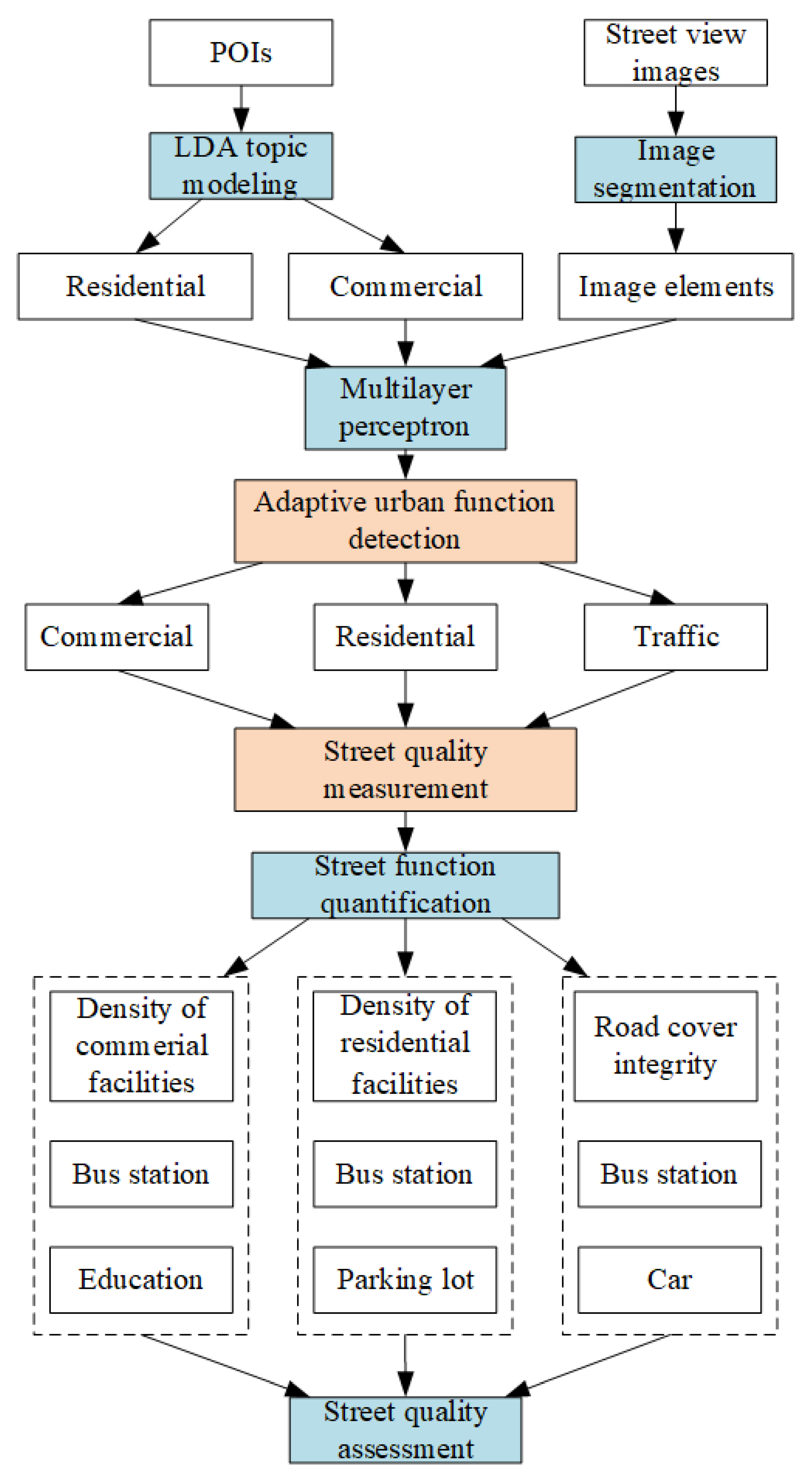
- Street view image segmentation is proposed using the pyramid scene parsing network (PSPNet) to delineate physical characteristics of street networks.
- A semantic urban function extraction approach is proposed using the Latent Dirichlet allocation (LDA) topic model with POI data to extract socioeconomic information.
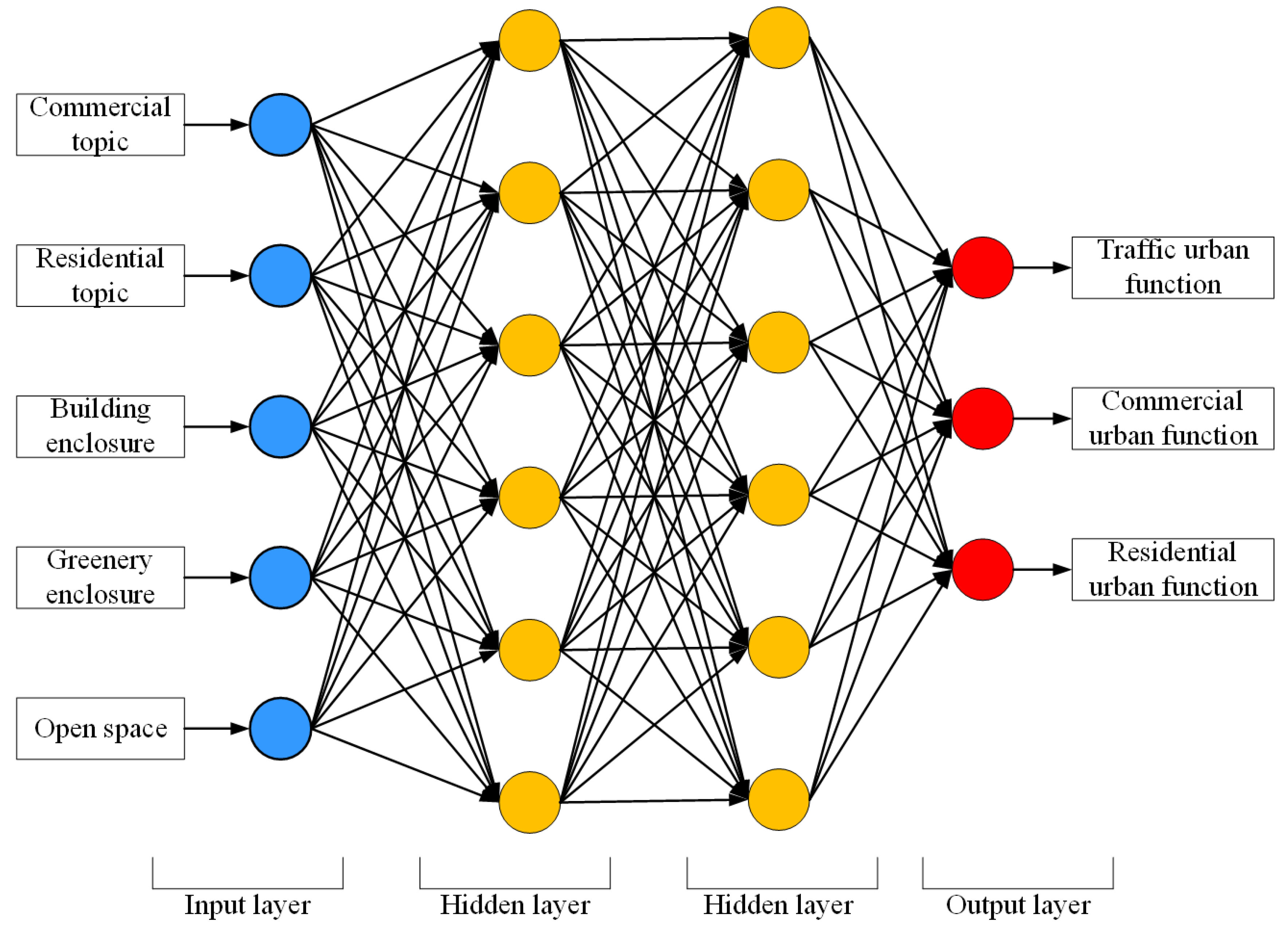
- Automatic urban function classification is proposed using a multilayer perceptron (MLP) model.
- A function-driven street quality assessment model is established to fit the adaptiveness of urban function variation.
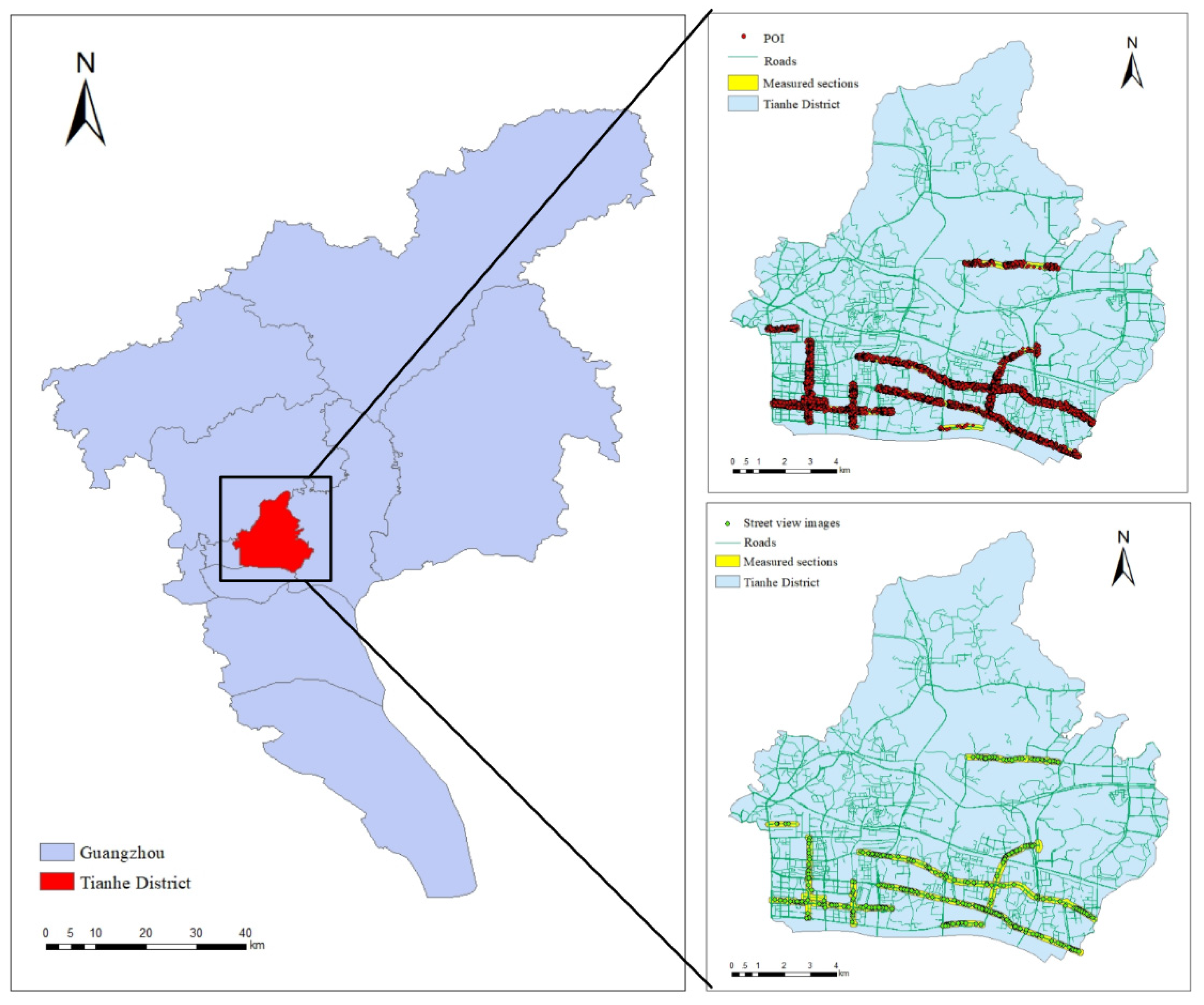
2. Study Area and Data
3. Adaptive Street Quality Assessment
3.1. Urban Function Detection
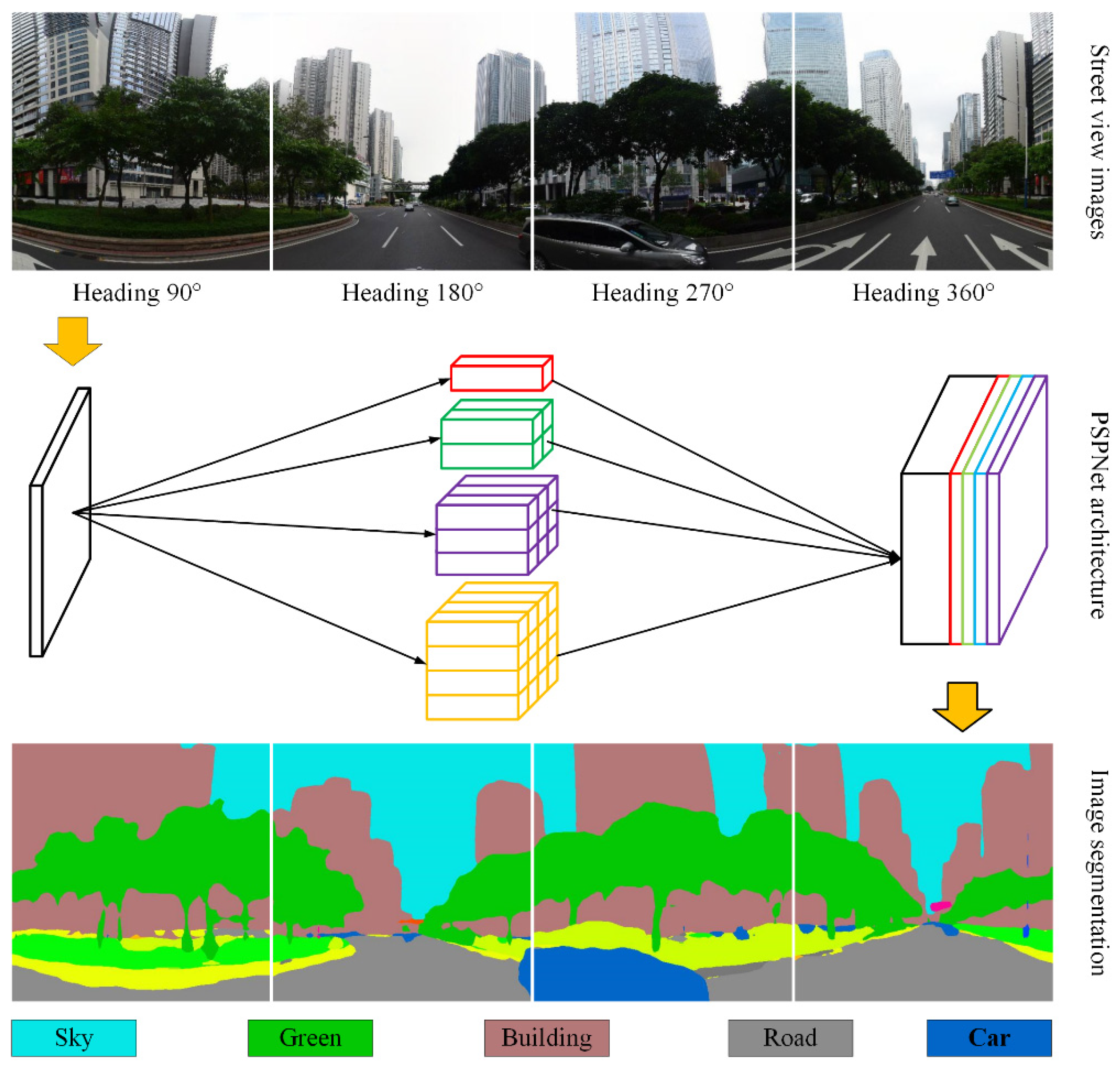
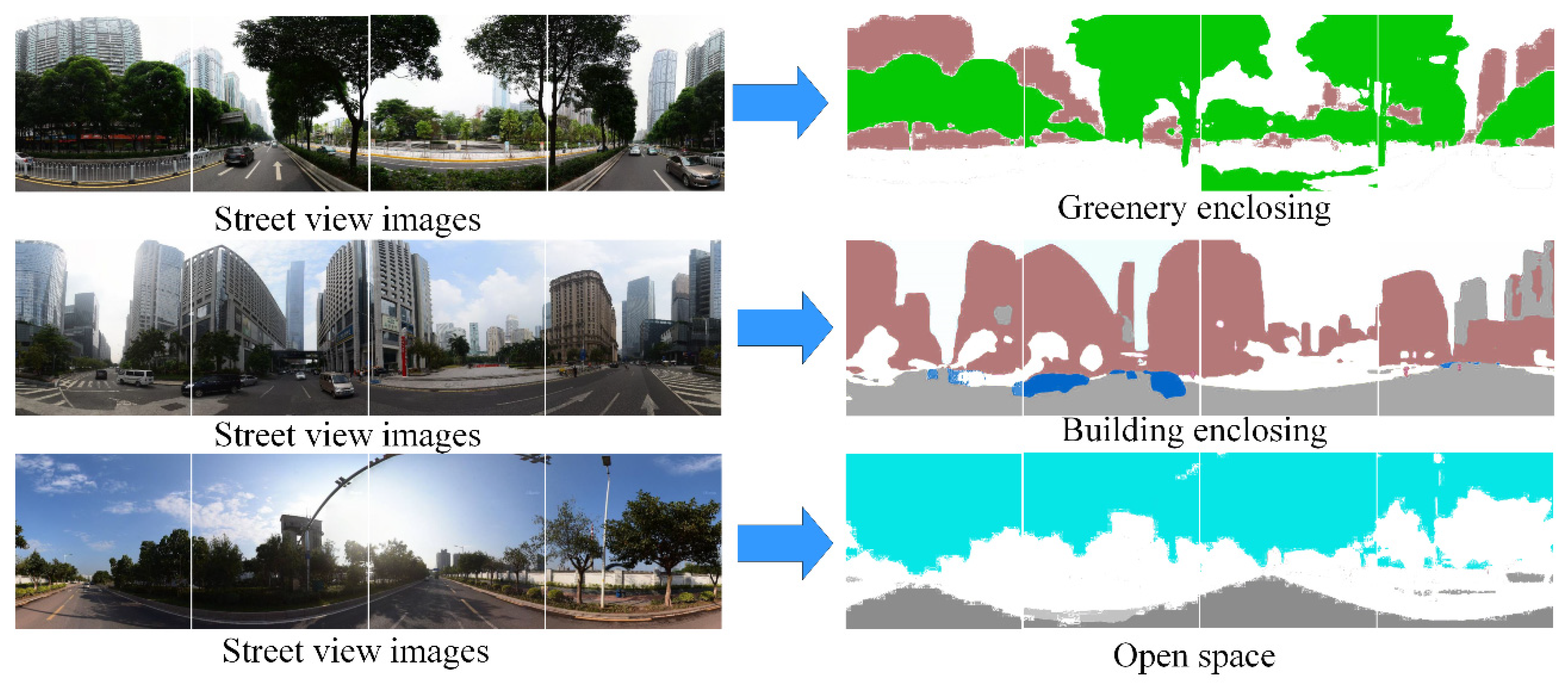
3.1.1. Street View Image Segmentation Using PSPNet
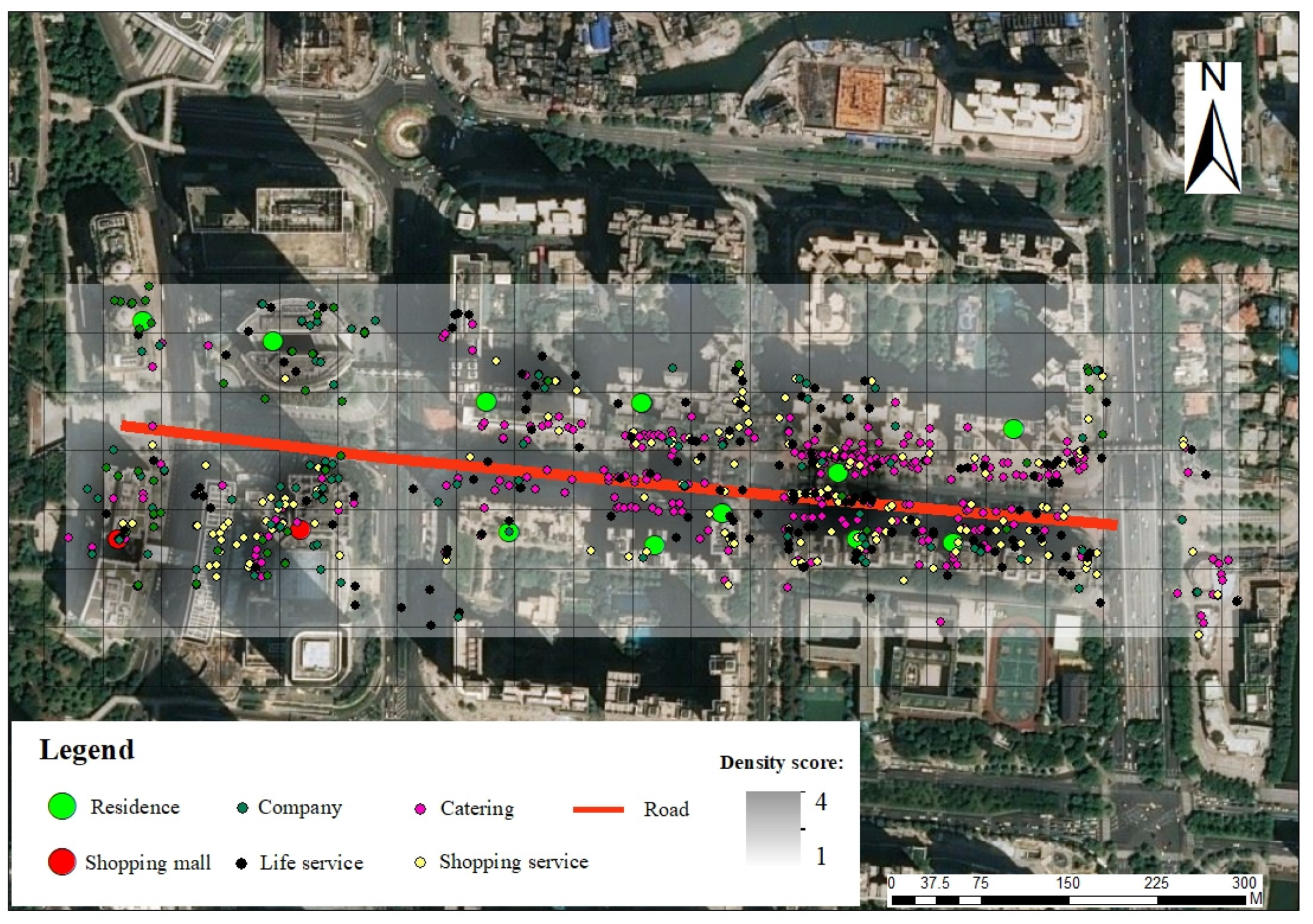
3.1.2. Semantic Function Extraction Using LDA Topic Modelling
3.1.3. Automatic Urban Function Classification
3.2. Adaptive Street Quality Assessment
3.2.1. Street Quality Description
3.2.2. Street Quality Weighting
4. Results
4.1. Street-Level Urban Function Detection
4.2. Adaptive Street Quality Assessment
4.3. Street Quality Validation
5. Discussion
6. Conclusions
Author Contributions
Acknowledgments
Conflicts of Interest
References
- Zhu, D.; Wang, N.; Wu, L.; Liu, Y. Street as a big geo-data assembly and analysis unit in urban studies: A case study using Beijing taxi data. Appl. Geogr. 2017, 86, 152–164. [Google Scholar] [CrossRef]
- Xing, H.; Meng, Y. Measuring urban landscapes for urban function classification using spatial metrics. Ecol. Indic. 2020, 108, 105722. [Google Scholar] [CrossRef]
- Ma, F.; Ren, F.; Yuen, K.F.; Guo, Y.; Zhao, C.; Guo, D. The Spatial Coupling Effect between Urban Public Transport and Commercial Complexes: A Network Centrality Perspective. Sustain. Cities Soc. 2019, 50, 101645. [Google Scholar] [CrossRef]
- Meng, Y.; Xing, H. Exploring the relationship between landscape characteristics and urban vibrancy: A case study using morphology and review data. Cities 2019, 95, 102389. [Google Scholar] [CrossRef]
- Porta, S.; Strano, E.; Iacoviello, V.; Messora, R.; Latora, V.; Cardillo, A.; Wang, F.; Scellato, S. Street centrality and densities of retail and services in Bologna, Italy. Environ. Plan. B Plan. Des. 2009, 36, 450–465. [Google Scholar] [CrossRef]
- Stubbings, P.; Peskett, J.; Rowe, F.; Arribas-Bel, D. A Hierarchical Urban Forest Index Using Street-Level Imagery and Deep Learning. Remote Sens. 2019, 11, 1395. [Google Scholar] [CrossRef]
- Chan, E.T.; Schwanen, T.; Banister, D. The role of perceived environment, neighbourhood characteristics, and attitudes in walking behaviour: Evidence from a rapidly developing city in China. Transportation 2019, 1–24. [Google Scholar] [CrossRef]
- Millward, H.; Spinney, J.; Scott, D. Active-transport walking behavior: Destinations, durations, distances. J. Trans. Geogr. 2013, 28, 101–110. [Google Scholar] [CrossRef]
- Liu, Y.; Liu, X.; Gao, S.; Gong, L.; Kang, C.; Zhi, Y.; Chi, G.; Shi, L. Social sensing: A new approach to understanding our socioeconomic environments. Ann. Assoc. Am. Geogr. 2015, 105, 512–530. [Google Scholar] [CrossRef]
- Xing, H.; Meng, Y. Integrating landscape metrics and socioeconomic features for urban functional region classification. Comput. Environ. Urban Syst. 2018, 72, 134–145. [Google Scholar] [CrossRef]
- Zhang, F.; Wu, L.; Zhu, D.; Liu, Y. Social sensing from street-level imagery: A case study in learning spatio-temporal urban mobility patterns. ISPRS J. Photogramm. Remote Sens. 2019, 153, 48–58. [Google Scholar] [CrossRef]
- Yin, L.; Wang, Z. Measuring visual enclosure for street walkability: Using machine learning algorithms and Google Street View imagery. Appl. Geogr. 2016, 76, 147–153. [Google Scholar] [CrossRef]
- Xing, H.; Meng, Y.; Hou, D.; Cao, F.; Xu, H. Exploring point-of-interest data from social media for artificial surface validation with decision trees. Int. J. Remote Sens. 2017, 38, 6945–6969. [Google Scholar] [CrossRef]
- Zhang, X.; Du, S.; Wang, Q. Hierarchical semantic cognition for urban functional zones with VHR satellite images and POI data. ISPRS J. Photogramm. Remote Sens. 2017, 132, 170–184. [Google Scholar] [CrossRef]
- Yue, Y.; Zhuang, Y.; Yeh, A.G.; Xie, J.-Y.; Ma, C.-L.; Li, Q.-Q. Measurements of POI-based mixed use and their relationships with neighbourhood vibrancy. Int. J. Geogr. Inf. Sci. 2017, 31, 658–675. [Google Scholar] [CrossRef]
- Cao, R.; Zhu, J.; Tu, W.; Li, Q.; Cao, J.; Liu, B.; Zhang, Q.; Qiu, G. Integrating Aerial and Street View Images for Urban Land Use Classification. Remote Sens. 2018, 10, 1553. [Google Scholar] [CrossRef]
- Helbich, M.; Yao, Y.; Liu, Y.; Zhang, J.; Liu, P.; Wang, R. Using deep learning to examine street view green and blue spaces and their associations with geriatric depression in Beijing, China. Environ. Int. 2019, 126, 107–117. [Google Scholar] [CrossRef]
- Li, Y.; Cheng, Q.; Wang, Z.; Shao, Z. ‘Big data’ for pedestrian volume: Exploring the use of Google Street View images for pedestrian counts. Appl. Geogr. 2015, 63, 337–345. [Google Scholar]
- Long, Y.; Liu, L. How green are the streets? An analysis for central areas of Chinese cities using Tencent Street View. PLoS ONE 2017, 12, e0171110. [Google Scholar] [CrossRef]
- Shen, Y.; Karimi, K. Urban function connectivity: Characterisation of functional urban streets with social media check-in data. Cities 2016, 55, 9–21. [Google Scholar] [CrossRef]
- Zhao, Y.; Zhang, H.; An, L.; Liu, Q. Improving the approaches of traffic demand forecasting in the big data era. Cities 2018, 82, 19–26. [Google Scholar] [CrossRef]
- Zhou, J.; Murphy, E. Day-to-day variation in excess commuting: An exploratory study of Brisbane, Australia. J. Transp. Geogr. 2019, 74, 223–232. [Google Scholar] [CrossRef]
- Huang, W.; Xu, S.; Yan, Y.; Zipf, A. An exploration of the interaction between urban human activities and daily traffic conditions: A case study of Toronto, Canada. Cities 2018, 84, 8–22. [Google Scholar] [CrossRef]
- Estupiñán, N.; Rodríguez, D.A. The relationship between urban form and station boardings for Bogota’s BRT. Transp. Res. Part A Policy Pract. 2008, 42, 296–306. [Google Scholar] [CrossRef]
- An, D.; Tong, X.; Liu, K.; Chan, E.H. Understanding the impact of built environment on metro ridership using open source in Shanghai. Cities 2019, 93, 177–187. [Google Scholar] [CrossRef]
- Yuan, J.; Zheng, Y.; Xie, X. Discovering Regions of Different Functions in a City Using Human Mobility and POIs. In Proceedings of the 18th ACM SIGKDD International Conference on Knowledge Discovery and Data Mining, Bejing, China, 12–16 August 2012; ACM: New York, NY, USA, 2012; pp. 186–194. [Google Scholar]
- Tu, W.; Cao, J.; Yue, Y.; Shaw, S.-L.; Zhou, M.; Wang, Z.; Chang, X.; Xu, Y.; Li, Q. Coupling mobile phone and social media data: A new approach to understanding urban functions and diurnal patterns. Int. J. Geogr. Inf. Sci. 2017, 31, 2331–2358. [Google Scholar] [CrossRef]
- Ríos, S.A.; Muñoz, R. Land Use detection with cell phone data using topic models: Case Santiago, Chile. Comput. Environ. Urban Syst. 2017, 61, 39–48. [Google Scholar] [CrossRef]
- Zhang, F.; Zhang, D.; Liu, Y.; Lin, H. Representing place locales using scene elements. Comput. Environ. Urban Syst. 2018, 71, 153–164. [Google Scholar] [CrossRef]
- Middel, A.; Lukasczyk, J.; Zakrzewski, S.; Arnold, M.; Maciejewski, R. Urban form and composition of street canyons: A human-centric big data and deep learning approach. Landsc. Urban Plan. 2019, 183, 122–132. [Google Scholar] [CrossRef]
- Zhao, H.; Shi, J.; Qi, X.; Wang, X.; Jia, J. Pyramid Scene Parsing Network. In Proceedings of the IEEE Conference on Computer Vision and Pattern Recognition, Salt Lake City, UT, USA, 21–26 July 2017; pp. 2881–2890. [Google Scholar]
- Zhou, B.; Zhao, H.; Puig, X.; Fidler, S.; Barriuso, A.; Torralba, A. Scene Parsing through Ade20k Dataset. In Proceedings of the IEEE Conference on Computer Vision and Pattern Recognition, Salt Lake City, UT, USA, 21–26 July 2017; pp. 633–641. [Google Scholar]
- Blei, D.M.; Ng, A.Y.; Jordan, M.I. Latent dirichlet allocation. J. Mach. Learning Res. 2003, 3, 993–1022. [Google Scholar]
- Xing, H.; Meng, Y.; Hou, D.; Song, J.; Xu, H. Employing Crowdsourced Geographic Information to Classify Land Cover with Spatial Clustering and Topic Model. Remote Sens. 2017, 9, 602. [Google Scholar] [CrossRef]
- Cybenko, G. Approximation by superpositions of a sigmoidal function. Math. Control Signals Syst. 1989, 2, 303–314. [Google Scholar] [CrossRef]
- Li, M.; Long, Y. The Coverage Ratio of Bus Stations and an Evaluation of Spatial Patterns of Major Chinese Cities. Urban Plan. Forum 2015, 226, 38–45. [Google Scholar]
- Saaty, T.L. What is the analytic hierarchy process? In Mathematical Models for Decision Support; Springer: Berlin/Heidelberg, Germany, 1988; pp. 109–121. [Google Scholar]
- Griffiths, T.L.; Steyvers, M. Finding scientific topics. Proc. Natl. Acad. Sci. USA 2004, 101 (Suppl. 1), 5228–5235. [Google Scholar] [CrossRef]
- Yao, Y.; Li, X.; Liu, X.; Liu, P.; Liang, Z.; Zhang, J.; Mai, K. Sensing spatial distribution of urban land use by integrating points-of-interest and Google Word2Vec model. Int. J. Geogr. Inf. Sci. 2017, 31, 825–848. [Google Scholar] [CrossRef]


| Target Layer | Criterion Level | Index Level |
|---|---|---|
| Street quality assessment | Traffic | Road traffic service level |
| Road area | ||
| Traffic organization and management | ||
| Road network connection | ||
| Residential | Quality of residential quarter | |
| Distribution of catering, shops, and living facilities | ||
| Cleanliness of street environment | ||
| Street greening | ||
| Road traffic service level | ||
| Commercial | Commercial service level around the road | |
| Road traffic | ||
| Traffic accessibility of commercial facilities | ||
| Shop density | ||
| Store diversity |
| Topic 3 | Topic 6 | Topic 7 | |||
|---|---|---|---|---|---|
| Words | Prob. | Words | Prob. | Words | Prob. |
| Life service | 0.680 | Incorporation | 0.294 | Parking lot | 0.233 |
| Convenience store | 0.158 | Exclusive shop | 0.228 | Intersection | 0.093 |
| Shop | 0.095 | Furniture store | 0.127 | Cultural place | 0.072 |
| Residence | 0.022 | Communal facilities | 0.071 | Bus stop | 0.024 |
| Restaurant | 0.021 | Fast food | 0.047 | Entrance | 0.008 |
| Decoration shop | 0.018 | Express | 0.023 | Hotel | 0.003 |
| Residential | Traffic | Commercial | Overall | |
|---|---|---|---|---|
| Producers’ accuracy | 100.0% | 33.3% | 80.0% | 64.3% |
| Users’ accuracy | 14.3% | 28.6% | 57.1% |
| Road Urban Function | Traffic Weight | Commercial Weight | Residential Weight |
|---|---|---|---|
| Traffic function | 60.00% | 20.00% | 20.00% |
| Commercial function | 16.38% | 53.90% | 29.73% |
| Residential function | 16.38% | 29.73% | 53.90% |
| ID | Road | Urban Function | Rank |
|---|---|---|---|
| 1 | Whampoa Avenue East (Chebei Road to beltway) | Traffic | 1 |
| 2 | Huaguan Road (Keyun Road to Gaotang Road) | Residential | 1 |
| 3 | Chebei Road (Guangyuan Expressway to Huangpu Road) | Traffic | 2 |
| 4 | Whampoa Avenue East (Huicai Road to Chebei Road) | Commercial | 2 |
| 5 | Huangpu Road Central (Tangxia Road to Kexin Road) | Commercial | 2 |
| 6 | Linhexi Road | Commercial | 2 |
| 7 | Chebei Road (Guangyuan Expressway to beltway) | Traffic | 2 |
| 8 | Huaguan Road (Gaotang Road to Daguan Road) | Traffic | 2 |
| 9 | Zhongshan Avenue Central (Guangzhou Expressway to Zhuji Road) | Commercial | 2 |
| 10 | Xiancun Road (Jinsui Road to Huacheng Avenue) | Commercial | 3 |
| 11 | Zhongshan Avenue West (Tianfu Road to Chebei Road) | Residential | 3 |
| 12 | Zhongshan Road (Chebei Road to Guangzhou Huancheng Expressway) | Traffic | 3 |
| 13 | Zhongshan Avenue West (Yangcheng Road to Tianfu Road) | Traffic | 3 |
| 14 | Xingsheng Road | Traffic | 3 |
| 15 | Huacheng Avenue | Commercial | 3 |
| 16 | Huangpu Road Central (Chebei Road to Huangpu Road East) | Traffic | 3 |
| 17 | Xiancun Road (Whampoa Road West to Jinsui Road) | Traffic | 3 |
| 18 | Huangpu Road Central (Chestwood Street to Tangxia Road) | Residential | 3 |
| 19 | Tiyu East Road (Tianhe Road to Whampoa Road West) | Residential | 4 |
| 20 | Racecourse Road | Residential | 4 |
| 21 | Tiyu East Road (Tianhe North Road to Tianhe Road) | Residential | 4 |
| ID | Street View | Road | Urban Function | Rank | Description |
|---|---|---|---|---|---|
| 2 |  | Huaguan Road (Keyun Road to Gaotang Road) | Residential | 1 | The road is open, and the buildings on both sides are under construction. |
| 17 |  | Chebei Road (Guangyuan Expressway to beltway) | Traffic | 2 | The green coverage on both sides of the road is good, the road surface is open, and commercial, residential facilities are few. |
| 46 |  | Huacheng Avenue | Commercial | 3 | High buildings stand on both sides of the road with high density |
| 59 |  | Racecourse Road | Residential | 4 | The road is clean and open, and the surrounding high-rise buildings stand |
© 2020 by the authors. Licensee MDPI, Basel, Switzerland. This article is an open access article distributed under the terms and conditions of the Creative Commons Attribution (CC BY) license (http://creativecommons.org/licenses/by/4.0/).
Share and Cite
Hu, F.; Liu, W.; Lu, J.; Song, C.; Meng, Y.; Wang, J.; Xing, H. Urban Function as a New Perspective for Adaptive Street Quality Assessment. Sustainability 2020, 12, 1296. https://doi.org/10.3390/su12041296
Hu F, Liu W, Lu J, Song C, Meng Y, Wang J, Xing H. Urban Function as a New Perspective for Adaptive Street Quality Assessment. Sustainability. 2020; 12(4):1296. https://doi.org/10.3390/su12041296
Chicago/Turabian StyleHu, Feng, Wei Liu, Junyu Lu, Chengpeng Song, Yuan Meng, Jun Wang, and Hanfa Xing. 2020. "Urban Function as a New Perspective for Adaptive Street Quality Assessment" Sustainability 12, no. 4: 1296. https://doi.org/10.3390/su12041296
APA StyleHu, F., Liu, W., Lu, J., Song, C., Meng, Y., Wang, J., & Xing, H. (2020). Urban Function as a New Perspective for Adaptive Street Quality Assessment. Sustainability, 12(4), 1296. https://doi.org/10.3390/su12041296