Adjustments of Socially Vulnerable Populations in Galveston County, Texas USA Following Hurricane Ike


Abstract
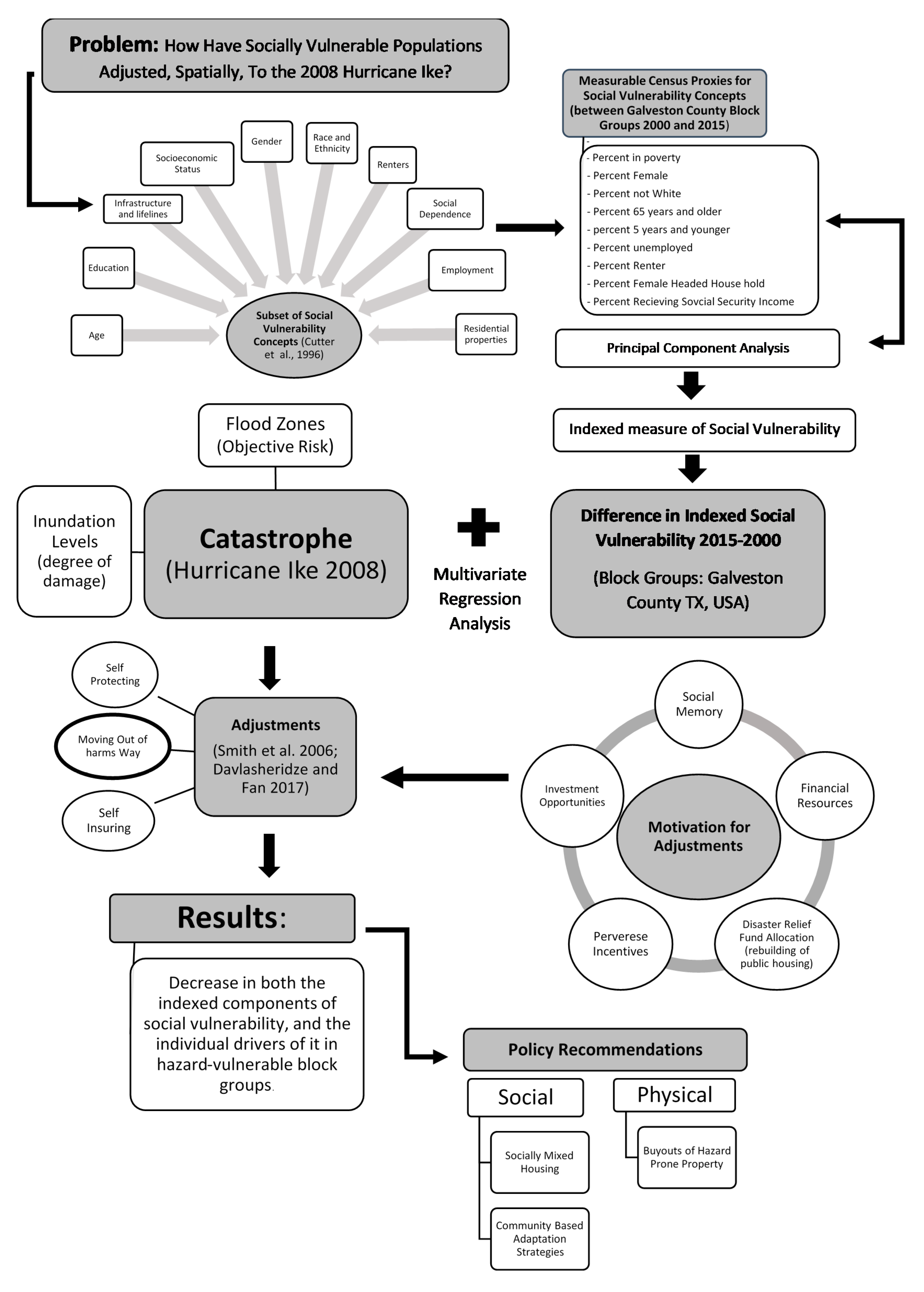
1. Introduction
2. Literature Review
2.1. Social Vulnerability
2.2. Household Adjustments
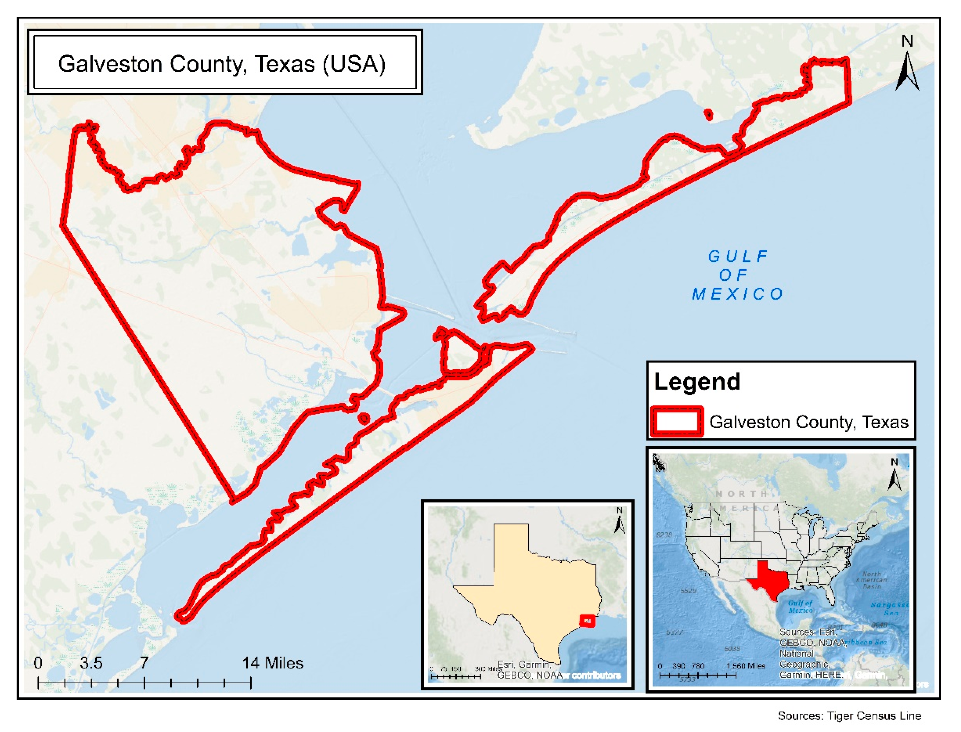
3. Study Area
4. Data
5. Methods
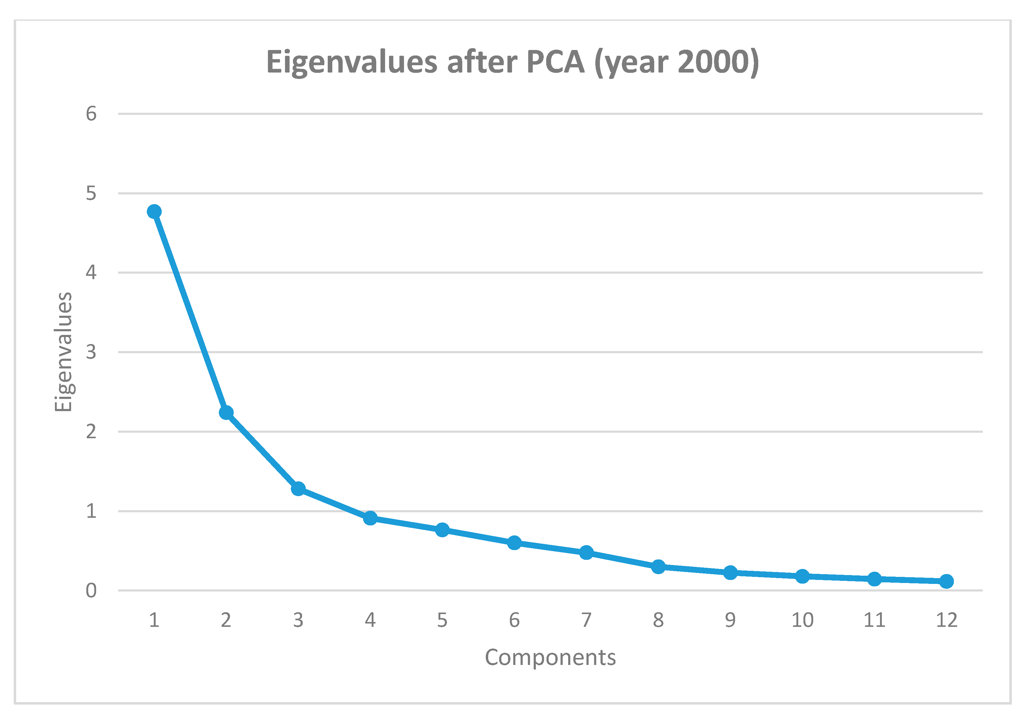
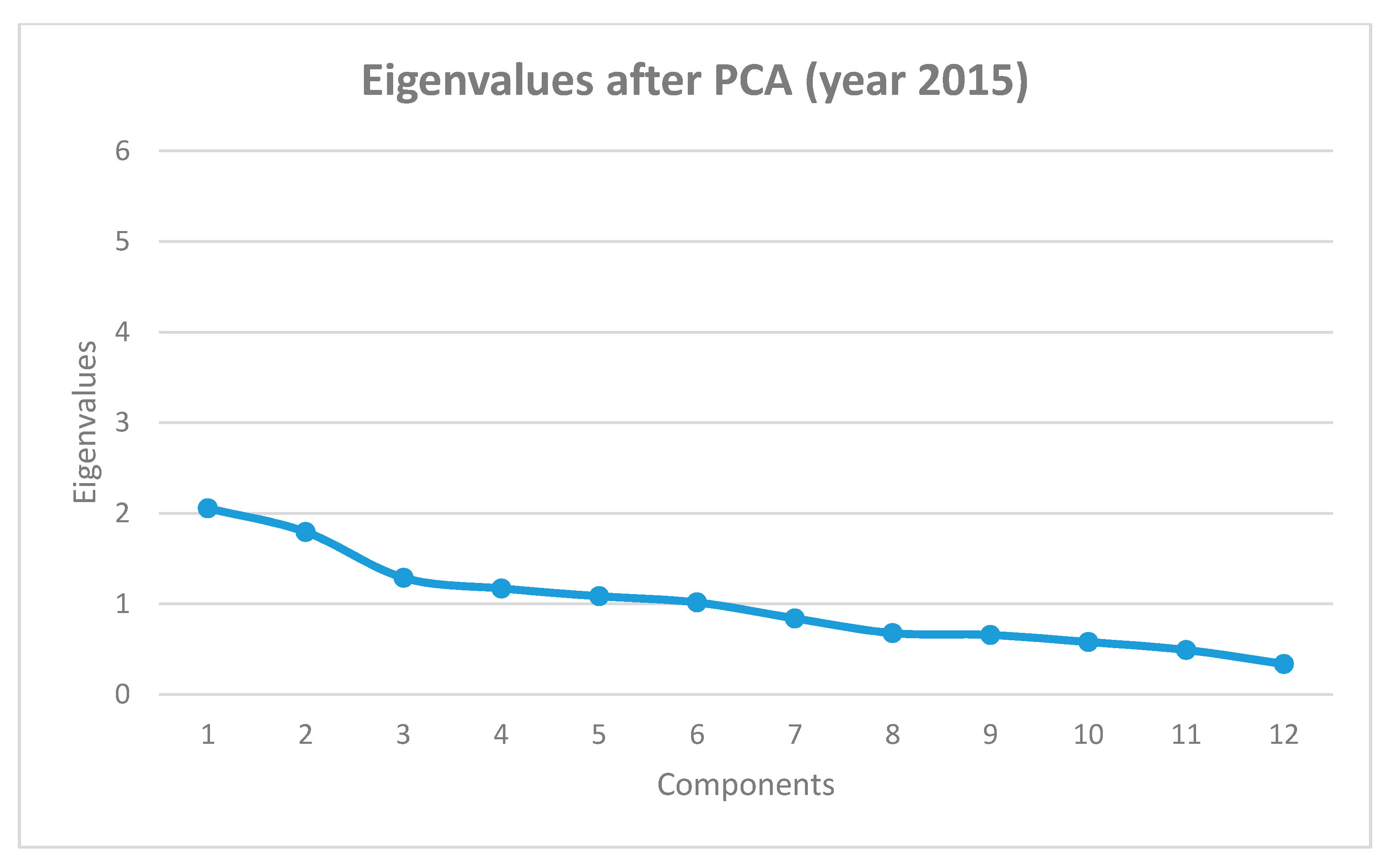
5.1. Principal Component Analysis
5.2. Estimation
5.2.1. The Ordinary Least Squares (OLS)
5.2.2. Spatial Regression Model
6. Results
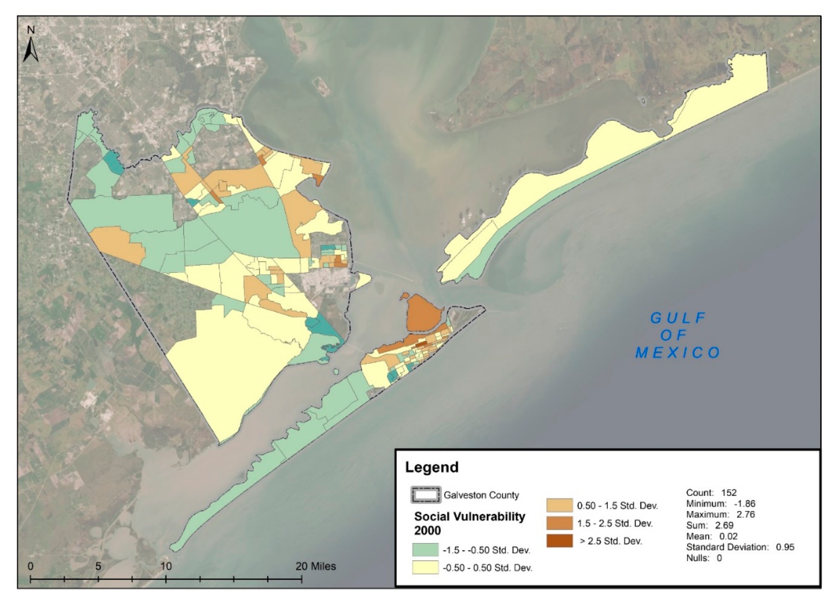
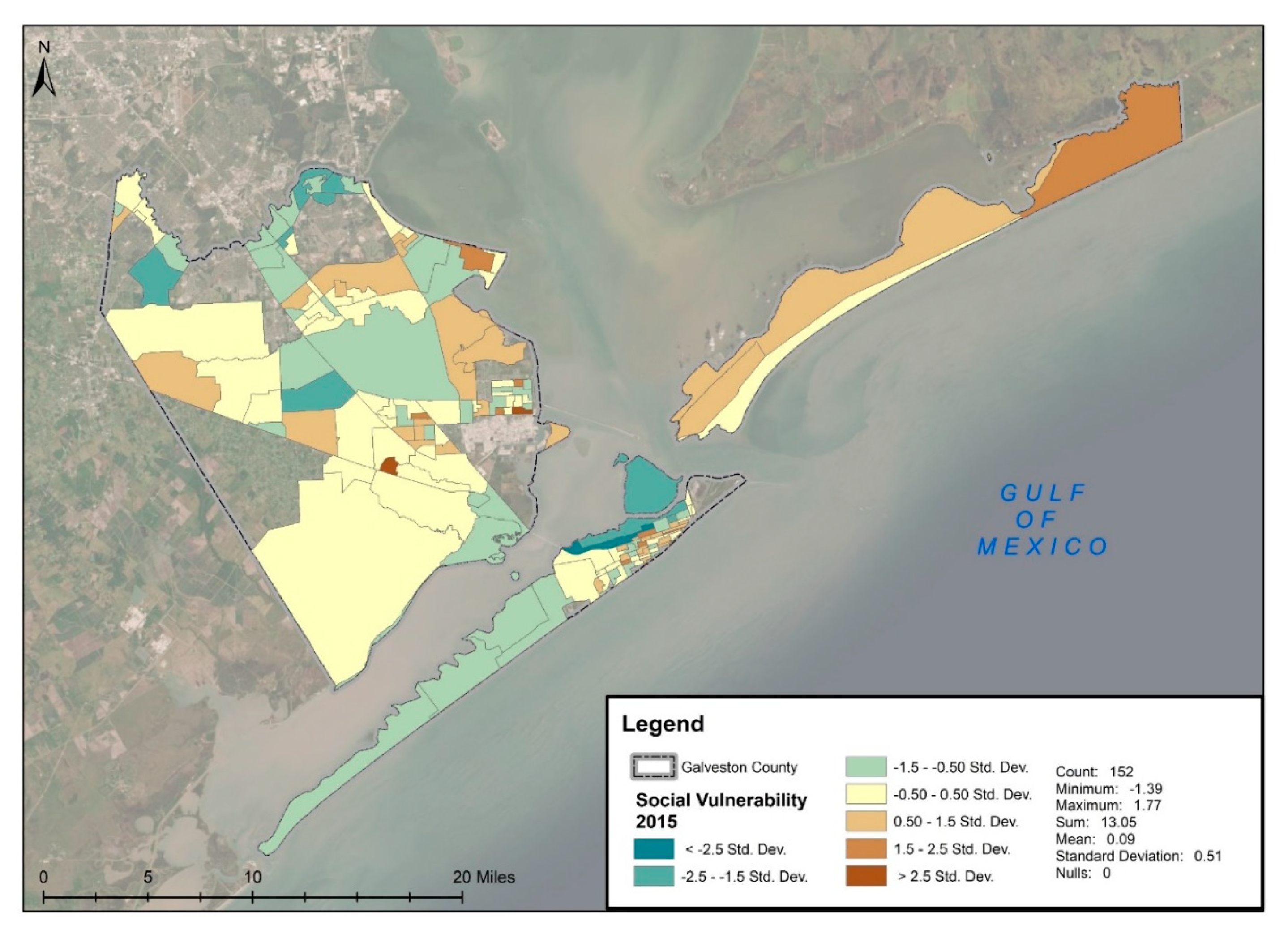
6.1. Social Vulnerability Index
6.2. Regression Results
7. Discussion and Limitations, Conclusions and Policy Recommendations
7.1. Discussion and Limitations
7.2. Conclusions and Policy Recommendations
Author Contributions
Funding
Acknowledgments
Conflicts of Interest
Appendix A

| Shares in 2000 | ||||
|---|---|---|---|---|
| Variable | Mean | Std. Dev | Min | Max |
| Percent in poverty | 20.12 | 14.76 | 0 | 78.63 |
| Percent female headed household | 15.10 | 11.08 | 0 | 57.21 |
| Percent no vehicle | 8.66 | 10.51 | 0 | 71.76 |
| Percent unemployed | 5.43 | 4.47 | 0 | 22.40 |
| Percent receiving social security income | 30.16 | 12.80 | 0 | 72.88 |
| Percent renter | 37.00 | 24.24 | 0 | 94.45 |
| Percent of mobile homes | 4.76 | 9.96 | 0 | 62.90 |
| Percent not white | 45.39 | 23.93 | 0 | 100.00 |
| Percent 5 years and under | 5.85 | 4.42 | 0 | 19.85 |
| Percent 65 years and older | 14.49 | 7.93 | 0 | 39.93 |
| Percent female | 51.01 | 6.38 | 22.23 | 68.84 |
| Percent with less than a 12th grade education | 15.68 | 11.49 | 0 | 51.73 |
| Shares in 2015 | ||||
|---|---|---|---|---|
| Variable | Mean | Std. Dev | Min | Max |
| Percent in poverty | 26.73 | 16.39 | 0 | 86.77 |
| Percent female headed household | 44.11 | 18.36 | 0 | 94.66 |
| Percent no vehicle | 10.28 | 11.65 | 0 | 69.73 |
| Percent unemployed | 4.78 | 4.84 | 0 | 53.72 |
| Percent receiving social security income | 25.45 | 10.94 | 0 | 63.10 |
| Percent renter | 35.23 | 22.51 | 0 | 98.22 |
| Percent of mobile homes | 5.97 | 10.88 | 0 | 55.67 |
| Percent not white | 42.70 | 26.19 | 3.62 | 100.00 |
| Percent 5 years and under | 7.92 | 3.40 | 0 | 17.08 |
| Percent 65 years and older | 12.55 | 7.00 | 0 | 43.44 |
| Percent female | 51.36 | 4.68 | 27.30 | 65.12 |
| Percent with less than a 12th grade education | 23.54 | 14.15 | 0 | 100.00 |
| Concept | Variable Measuring Concept |
|---|---|
| Socioeconomic status (income, political power, prestige) | Percent in poverty |
| Gender | Percent female |
| Race and Ethnicity | Percent not white |
| Age | Percent 65 years and olderPercent 5 years and under |
| Employment loss | Percent unemployed |
| Renters | Percent renter |
| Family Structure | Percent female headed household |
| Social dependence | Percent receiving social security income |
| Education | Percent with less than a 12th grade education |
| Infrastructure and Lifelines | Percent no vehicle |
| Residential Property | Percent of mobile homes |
| Variable | Mean | Std. Dev | Min | Max |
|---|---|---|---|---|
| 2000 SV | 0.02 | 0.95 | −1.86 | 2.76 |
| 2015 SV | 0.09 | 0.51 | −1.39 | 1.77 |
| LM Value | Probability | |
|---|---|---|
| Dpctpoverty | ||
| LM Error | 0.169 | 0.681 |
| LM LAG | 3.741 | 0.053 * |
| Dpctheadfem | ||
| LM Error | 4.933 | 0.026 ** |
| LM LAG | 0.062 | 0.804 |
| Dpercentnov | ||
| LM Error | 0.054 | 0.817 |
| LM LAG | 3.279 | 0.07 * |
| Dpctunemplo | ||
| LM Error | 0.003 | 0.956 |
| LM LAG | 0.342 | 0.559 |
| Dpctsocials | ||
| LM Error | 0.717 | 0.397 |
| LM LAG | 1.346 | 0.246 |
| Dpercentren | ||
| LM Error | 2.212 | 0.137 |
| LM LAG | 4.088 | 0.043 ** |
| Dpctmobile | ||
| LM Error | 0.002 | 0.967 |
| LM LAG | 0.812 | 0.367 |
| Dpctnotwhit | ||
| LM Error | 1.754 | 0.185 |
| LM LAG | 0.005 | 0.942 |
| Dpctyoung | ||
| LM Error | 2.244 | 0.134 |
| LM LAG | 3.318 | 0.069 * |
| Dpctold | ||
| LM Error | 0.162 | 0.687 |
| LM LAG | 0.569 | 0.451 |
| Dpctfemale | ||
| LM ERROR | 0.997 | 0.318 |
| LM LAG | 2.312 | 0.128 |
| Dpctunder12 | ||
| LM Error | 2.021 | 0.155 |
| LM LAG | 0.05 | 0.824 |
| DSV | ||
| LM Error | 0.059 | 0.808 |
| LM LAG | 0.117 | 0.732 |


References
- Wing, O.E.; Pinter, N.; Bates, P.D.; Kousky, C. New insights into US flood vulnerability revealed from flood insurance big data. Nat. Commun. 2020, 11, 1444. [Google Scholar] [CrossRef] [PubMed]
- IPCC. Climate Change 2013: The Physical Science Basis. Contribution of Working Group I to the Fifth Assessment Report of the Intergovernmental Panel on Climate Change; Stocker, T.F., Qin, D., Plattner, G.-K., Tignor, M., Allen, S.K., Boschung, J., Nauels, A., Xia, Y., Bex, V., Midgley, P.M., Eds.; Cambridge University Press: Cambridge, UK; New York, NY, USA, 2013; 1535p. [Google Scholar]
- Creel, L. Ripple Effects: Population and Coastal Regions; Population Reference Bureau: Washington, DC, USA, 2003.
- Adger, W.N. Social Vulnerability to Climate Change and Extremes in Coastal Vietnam. World Dev. 1999, 27, 249–269. [Google Scholar] [CrossRef]
- Brooks, N.; Adger, W.N.; Kelly, P.M. The determinants of vulnerability and adaptive capacity at the national level and the implications for adaptation. Glob. Environ. Chang. 2005, 15, 151–163. [Google Scholar] [CrossRef]
- Holling, C.S. Resilience and Stability of Ecological Systems. Annu. Rev. Ecol. Syst. 1973, 4, 1–23. [Google Scholar] [CrossRef]
- Walker, B.; Holling, C.S.; Carpenter, S.R.; Kinzig, A.P. Resilience, Adaptability and Transformability in Social-ecological Systems. Ecol. Soc. 2004, 9, 9. [Google Scholar] [CrossRef]
- Bakkensen, L.; Ma, L. Forthcoming. Sorting Over Flood Risk and Implications for Policy Reform. J. Environ. Econ. Manag. 2020, 104, 102362. [Google Scholar] [CrossRef]
- Billings, S.B.; Gallagher, E.; Ricketts, L. Let the Rich Be Flooded: The Unequal Impact of Hurricane Harvey on Household Debt. SSRN Electron. J. 2019. [Google Scholar] [CrossRef]
- Howell, J.; Elliott, J.R. Damages Done: The Longitudinal Impacts of Natural Hazards on Wealth Inequality in the United States. Soc. Probl. 2018, 66, 448–467. [Google Scholar] [CrossRef]
- Fischer, A.P.; Frazier, T.G. Social Vulnerability to Climate Change in Temperate Forest Areas: New Measures of Exposure, Sensitivity, and Adaptive Capacity. Ann. Am. Assoc. Geogr. 2018, 108, 658–678. [Google Scholar] [CrossRef]
- Wijkman, A.; Timberlake, L. Natural Disasters: Acts of God or Acts of Man? New Society: Philadelphia, PA, USA, 1988. [Google Scholar]
- Younus, M.; Kabir, M. Climate Change Vulnerability Assessment and Adaptation of Bangladesh: Mechanisms, Notions and Solutions. Sustainability 2018, 10, 4286. [Google Scholar] [CrossRef]
- Adger, W.N.; Hughes, T.P.; Folke, C.; Carpenter, S.R.; Rockstrom, J. Social-Ecological Resilience to Coastal Disasters. Science 2005, 309, 1036–1039. [Google Scholar] [CrossRef] [PubMed]
- Tidball, K.G.; Krasny, M.E.; Svendsen, E.; Campbell, L. Stewardship, learning and memory in disaster resilience. Environ. Educ. Res. 2010, 16, 591–609. [Google Scholar] [CrossRef]
- Colten, C.E.; Sumpter, A.R. Social memory and resilience in New Orleans. Nat. Hazards 2008, 48, 355–364. [Google Scholar] [CrossRef]
- Benioff, R.; Guill, S.; Lee, J. (Eds.) Vulnerability and Adaptation Assessments; Environmental Science and Technology Library; Springer: Berlin/Heidelberg, Germany, 1996. [Google Scholar] [CrossRef]
- Cai, H.; Lam, N.S.N.; Qiang, Y.; Zou, L.; Correll, R.M.; Mihunov, V. A synthesis of disaster resilience measurement methods and indices. Int. J. Disaster Risk Reduct. 2018, 31, 844–855. [Google Scholar] [CrossRef]
- Smith, J.B.; Huq, S.; Lenhart, S.; Mata, L.J.; Nemesová, I.; Touré, S. (Eds.) Vulnerability and Adaptation to Climate Change: Interim Results from the U.S. Country Studies Program, 1996th ed.; Environmental Science and Technology Library (8); Springer: Berlin/Heidelberg, Germany, 1996. [Google Scholar]
- Cutter, S.L. Social Vulnerability to Environmental. Soc. Sci. Q. 2003, 84, 242–262. [Google Scholar] [CrossRef]
- Davlasheridze, M.; Fan, Q. Household Adjustments to Hurricane Katrina. Rev. Reg. Stud. 2017, 47, 93–112. [Google Scholar]
- Smith, K.V.; Carbone, J.C.; Pope, J.C.; Hallstrom, D.G.; Darden, M.E. Adjusting to natural disasters. J. Risk Uncertain. 2006, 33, 37–54. [Google Scholar] [CrossRef]
- Cutter, S.L. Vulnerability to Environmental Hazards. Prog. Hum. Geogr. 1996, 20, 529–539. [Google Scholar] [CrossRef]
- Pelling, M. Natural Disasters and Development in a Globalizing World; Routledge: New Fetter Lane, London, UK, 2006. [Google Scholar]
- Brooks, N.; Adger, N.W. Country Level Risk Measures of Climate-Related Natural Disasters and Implications for Adaptation to Climate Change; Tyndall Centre Working Paper 26; Tyndall Centre for Climate Change Research: Norwich, UK, 2003; 26p. [Google Scholar]
- Adger, W.N. Social Aspects of Adaptive Capacity. In Climate Change, Adaptive Capacity and Development London; Imperial College Press: London, UK, 2003; pp. 29–49. [Google Scholar]
- Bohle, H.G.; Downing, T.E.; Watts, M.J. Climate change and social vulnerability. Glob. Environ. Chang. 1994, 4, 37–48. [Google Scholar] [CrossRef]
- Daniels, R.J.; Kettl, D.F.; Kunreuther, H. On Risk and Disaster Lessons from Hurricane Katrina; University of Pennsylvania Press: Philadelphia, PA, USA, 2011. [Google Scholar]
- Flanagan, B.E.; Gregory, E.W.; Hallisey, E.J.; Heitgerd, J.L.; Lewis, B. A Social Vulnerability Index for Disaster Management. J. Homel. Secur. Emerg. Manag. 2011, 8, 8. [Google Scholar] [CrossRef]
- Smit, B.; Pilifosova, O. From Adaptation to Adaptive Capacity and Vulnerability Reduction. Clim. Chang. Adapt. Capacit. Dev. 2003, 9–28. [Google Scholar] [CrossRef]
- Davlasheridze, M.; Fan, Q. Valuing Seawall Protection in the Wake of Hurricane Ike. Econ. Disasters Clim. Chang. 2019, 3, 257–279. [Google Scholar] [CrossRef]
- Elliott, J.R.; Pais, J. Race, class, and Hurricane Katrina: Social differences in human responses to disaster. Soc. Sci. Res. 2006, 35, 295–321. [Google Scholar] [CrossRef]
- Fothergill, A.; Peek, L.A. Poverty and Disasters in the United States: A Review of Recent Sociological Findings. Nat. Hazards 2004, 32, 89–110. [Google Scholar] [CrossRef]
- Eidson, M.; Lybarger, J.A.; Parsons, J.E.; MacCormack, J.N.; Freeman, J.I. Risk Factors for Tornado Injuries. Int. J. Epidemiol. 1990, 19, 1051–1056. [Google Scholar] [CrossRef]
- Morrow, B.H. Identifying and Mapping Community Vulnerability. Disasters 1999, 23, 1–18. [Google Scholar] [CrossRef]
- Peek-Asa, C.; Ramirez, M.; Seligson, H.; Shoaf, K. Seismic, Structural, and Individual Factors Associated with Earthquake Related Injury. Inj. Prev. 2003, 9, 62–66. [Google Scholar] [CrossRef]
- Rosenkoetter, M.M.; Covan, E.K.; Cobb, B.K.; Bunting, S.; Weinrich, M. Perceptions of Older Adults Regarding Evacuation in the Event of a Natural Disaster. Public Health Nurs. 2007, 24, 160–168. [Google Scholar] [CrossRef]
- Schmidlin, T.W.; King, P.S. Risk Factors for Death in the 27 March 1994 Georgia and Alabama Tornadoes. Disasters J. Disaster Stud. Manag. 1995, 19, 170–177. [Google Scholar] [CrossRef]
- White, G.W.; Fox, M.H.; Rooney, C.; Cahill, A. Assessing the Impact of Hurricane Katrina on Persons with Disabilities: Interim Report; Research and Training Center on Independent Living, University of Kansas: Lawrence, KS, USA, 2006. [Google Scholar]
- Anttila-Hughes, J.K.; Hsiang, S.M. Destruction, Disinvestment, and Death: Economic and Human Losses Following Environmental Disaster. SSRN Electron. J. 2013. [Google Scholar] [CrossRef]
- Coffman, M.; Noy, I. Hurricane Iniki: Measuring the long-term economic impact of a natural disaster using synthetic control. Environ. Dev. Econ. 2011, 17, 187–205. [Google Scholar] [CrossRef]
- Lynham, J.; Noy, I.; Page, J. The 1960 Tsunami in Hawaii: Long-Term Consequences of a Coastal Disaster. World Dev. 2017, 94, 106–118. [Google Scholar] [CrossRef]
- Nakagawa, Y.; Shaw, R. Social Capital: A Missing Link to Disaster Recovery. Int. J. Mass Emerg. Disasters 2004, 22, 5–34. [Google Scholar]
- Varley, A. Disasters, Development and Environment; Chichester, J., Ed.; Wiley: Hoboken, NJ, USA, 1994. [Google Scholar]
- Kousky, C.; Michel-Kerjan, E.O.; Raschky, P.A. Does federal disaster assistance crowd out flood insurance? J. Environ. Econ. Manag. 2018, 87, 150–164. [Google Scholar] [CrossRef]
- Davlasheridze, M.; Miao, Q. Does governmental assistance affect private decisions to insure? An empirical analysis of flood insurance purchases. Land Econ. 2019, 95, 124–145. [Google Scholar] [CrossRef]
- Baade, R.A.; Baumann, R.; Matheson, V. Estimating the Economic Impact of Natural and Social Disasters, with an Application to Hurricane Katrina. Urban Stud. 2007, 44, 2061–2076. [Google Scholar] [CrossRef]
- Kousky, C.; Luttmer, E.F.; Zeckhauser, R. Private Investment and Government Protection. J. Risk Uncertain. 2006. [Google Scholar] [CrossRef]
- Kunreuther, H. Mitigation and Financial Risk Management for Natural Hazards. Geneva Pap. Risk Insur.—Issues Pract. 2001, 26, 277–296. [Google Scholar] [CrossRef]
- Lewis, T.; Nickerson, D. Self-insurance against natural disasters. J. Environ. Econ. Manag. 1989, 16, 209–223. [Google Scholar] [CrossRef]
- Binder, S.B.; Baker, C.K.; Barile, J.P. Rebuild or Relocate? Resilience and Postdisaster Decision-Making after Hurricane Sandy. Am. J. Community Psychol. 2015, 56, 180–196. [Google Scholar] [CrossRef]
- Miao, Q.; Davlasheridze, M. 2020 Managed retreat in the face of climate change: What influences buyouts of flood-prone properties. Working Paper.
- Chamlee-Wright, E. The Cultural and Political Economy of Recovery: Social Learning in a Post-Disaster Environment; Routledge: London, UK, 2013. [Google Scholar]
- Olsson, P.; Folke, C.; Berkes, F. Adaptive Comanagement for Building Resilience in Social? Ecological Systems. Environ. Manag. 2004, 34, 34. [Google Scholar] [CrossRef]
- Lidskog, R. Invented Communities and Social Vulnerability: The Local Post-Disaster Dynamics of Extreme Environmental Events. Sustainability 2018, 10, 4457. [Google Scholar] [CrossRef]
- Younus, M.A. An assessment of vulnerability and adaptation to cyclones through impact assessment guidelines: A bottom-up case study from Bangladesh coast. Nat. Hazards 2017, 89, 1437–1459. [Google Scholar] [CrossRef]
- Younus, M.A. Adapting to climate change in the coastal regions of Bangladesh: Proposal for the formation of community-based adaptation committees. Environ. Hazards 2017, 16, 1–29. [Google Scholar] [CrossRef]
- Watt, P.S. Social Housing and Urban Renwal: A Cross National Perspective; Emerald Publishing Limited: Bingley, UK, 2017. [Google Scholar]
- Rohe, W.M.; Burby, R.J. Fear of Crime in Public Housing. Environ. Behav. 1988, 20, 700–720. [Google Scholar] [CrossRef]
- Sampson, R.J.; Wilson, W.J. Toward a Theory of Race, Crime, and Urban Inequality. In Race, Crime, and Justice; Routledge: London, UK, 1995; pp. 177–188. [Google Scholar]
- Cutter, S.L.; Burton, C.G.; Emrich, C.T. Disaster Resilience Indicators for Benchmarking Baseline Conditions. J. Homel. Secur. Emerg. Manag. 2010, 7. [Google Scholar] [CrossRef]
- Jonkman, S.N.; Maaskant, B.; Boyd, E.; Levitan, M.L. Loss of Life Caused by the Flooding of New Orleans After Hurricane Katrina: Analysis of the Relationship Between Flood Characteristics and Mortality. Risk Anal. 2009, 29, 676–698. [Google Scholar] [CrossRef]
- Gallie, D.; Paugam, S.; Jacobs, S. Unemployment, Poverty and Social Isolation: Is there a vicious circle of social exclusion? Eur. Soc. 2003, 5, 1–32. [Google Scholar] [CrossRef]
- Elliott, J.R.; Gotham, K.F.; Milligan, M.J. Framing the Urban: Struggles Over HOPE VI and New Urbanism in a Historic City. City Community 2004, 3, 373–394. [Google Scholar] [CrossRef]
- Cinner, J.E.; Adger, W.N.; Allison, E.H.; Barnes, M.L.; Brown, K.; Cohen, P.J.; Morrison, T.H. Building adaptive capacity to climate change in tropical coastal communities. Nat. Clim. Chang. 2018, 8, 117–123. [Google Scholar] [CrossRef]
- Byrne, J.P. Two cheers for gentrification. Howard Law J. 2003, 46, 405–432. [Google Scholar]
- Goetz, E.G. Better Neighborhoods, Better Outcomes? Explaining Relocation Outcomes in Hope VI. SSRN Electron. J. 2010. [Google Scholar] [CrossRef]
- Keene, D.E.; Geronimus, A.T. “Weathering” HOPE VI: The Importance of Evaluating the Population Health Impact of Public Housing Demolition and Displacement. J. Urban Health 2011, 88, 417–435. [Google Scholar] [CrossRef]
- Popkin, S.J.; Levy, D.K.; Buron, L. Has Hope Vi Transformed Residents Lives? New Evidence from The Hope Vi Panel Study. Hous. Stud. 2009, 24, 477–502. [Google Scholar] [CrossRef]
- Crow, K. As Port Aransas Rebuilds after Hurricane Harvey What Will This Coastal Town Become? Corpus Christi Caller-Times, 2018. Available online: https://www.caller.com/story/news/local/2018/05/01/port-aransas-rebuilds-after-Hurricane-harvey-what-coastal-texas-town-become/420334002/ (accessed on 15 May 2018).
- Roth, D. Texas Hurricane History. 2000. Available online: http://www.srh.noaa.gov/lch/research/txhur.php (accessed on 10 September 2018).
- NOAA. Patterns and Projections of High Tide Flooding along the U.S. Coastline Using a Common Impact Threshold; (Tech. No. NOS CO-OPS 086); NOAA: Silver Spring, MD, USA, 2018. [Google Scholar]
- Hayden, R.E. Storm Surge and “Certain Death”: Interviews with Texas Coastal Residents following Hurricane Ike. Am. Meteorol. Surv. 2010, 2, 174–189. [Google Scholar]
- Kennedy, A.; Rogers, S.; Sallenger, A.; Gravois, U.; Zachry, B.; Dosa, M.; Zarama, F. Building Destruction from Waves and Surge on the Bolivar Peninsula during Hurricane Ike. J. Waterw. Port Coast. Ocean Eng. 2011, 137, 132–141. [Google Scholar] [CrossRef]
- U.S. Census Bureau; American Community Survey. American Community Survey 5-Year Estimates, Tables: h045; h007; p062; p008; h032; p013; p052; h019; p043; p037; p007; Generated by Emily Fucile Sanchez; Using American Fact Finder. 2000. Available online: http://factfinder.census.gov (accessed on 22 November 2017).
- U.S. Census Bureau; American Community Survey. American Community Survey. American Community Survey 5-Year Estimates, Tables: b25044; b25003; b19055; b01001; b25032; b01002; b19001; b11001; b23025; b15002; b03002; Generated by Emily Fucile Sanchez; Using American Fact Finder. 2015. Available online: http://factfinder.census.gov (accessed on 1 March 2018).
- Harris County Flood Control District. Available online: https://www.hcfcd.org/ (accessed on 10 September 2017).
- FEMA. National Flood Hazard Layer. April 2017. Available online: https://www.fema.gov/national-flood-hazard-layer-nfhl (accessed on 10 October 2017).
- Campbell, N.A.; Atchley, W.R. The Geometry of Canonical Variate Analysis. Syst. Biol. 1981, 30, 268–280. [Google Scholar] [CrossRef]
- Cutter, S.L.; Finch, C. Temporal and spatial changes in social vulnerability to natural hazards. Proc. Natl. Acad. Sci. USA 2008, 105, 2301–2306. [Google Scholar] [CrossRef]
- Hamideh, S.; Rongerude, J. Social vulnerability and participation in disaster recovery decisions: Public housing in Galveston after Hurricane Ike. Nat. Hazards 2018, 93, 1629–1648. [Google Scholar] [CrossRef]
- Belcher, J.C.; Bates, F.L. Aftermath of natural disasters: Coping through residential mobility. Disasters 1983, 7, 118–128. [Google Scholar] [CrossRef] [PubMed]
- Fordham, M.H. The intersection of gender and social class in disaster: Balancing resilience and vulnerability. Int. J. Mass Emerg. Disasters 1999, 17, 15–36. [Google Scholar] [PubMed]
- Haas, E.; Kates, R.W.; Bowden, M.J. Reconstruction Following Disaster; MIT: Cambridge, MA, USA, 1977. [Google Scholar]
- Morrow-Jones, H.A.; Morrow-Jones, C.R. Mobility Due to Natural Disaster: Theoretical Considerations and Preliminary Analyses. Disasters 1991, 15, 126–132. [Google Scholar] [CrossRef] [PubMed]
- Myers, C.A.; Slack, T.; Singelmann, J. Social vulnerability and migration in the wake of disaster: The case of Hurricane s Katrina and Rita. Popul. Environ. 2008, 29, 271–291. [Google Scholar] [CrossRef]
- Berke, P.; Yu, S.; Malecha, M.; Cooper, J. Plans that Disrupt Development: Equity Policies and Social Vulnerability in Six Coastal Cities. J. Plan. Educ. Res. 2019. [Google Scholar] [CrossRef]


| Variable | Description | Mean | Std. Dev. | Min | Max |
|---|---|---|---|---|---|
| Dpctpoverty | in the % of the population in Poverty | −5.38 | 13.60 | −44.64 | 38.80 |
| Lpctpoverty | % of the population in Poverty | 27.69 | 15.32 | 1.35 | 72.96 |
| Dpctheadfem | in the % of the population in with a Female Headed Household | −29.65 | 17.33 | −78.96 | 9.99 |
| Lpctheadfem | % of the population in with a Female Headed Household | 45.64 | 16.72 | 10.65 | 84.39 |
| Dpercentnov | in the percent of the population with no vehicle | −0.75 | 9.86 | −50.57 | 33.94 |
| Lpercentnov | % of the population with no vehicle | 10.60 | 11.35 | 0.00 | 62.55 |
| Dpctunemplo | in the % of the population unemployed | 1.10 | 5.45 | −20.55 | 19.22 |
| Lpctunemplo | % of the population unemployed | 4.69 | 3.49 | 0.00 | 20.55 |
| Dpctsocials | in the %t of the population recieving Social Security | 4.75 | 12.35 | −28.58 | 44.23 |
| Lpctsocials | % of the population recieving Social | 26.41 | 10.93 | 3.90 | 63.10 |
| Dpercentren | in the % of the population renting housing | 2.98 | 14.11 | −32.65 | 41.29 |
| Lpercentren | % of the population renting housing | 37.41 | 22.27 | 1.22 | 89.48 |
| Dpctmobile | in the % of the population living in Mobile Homes | −0.72 | 5.83 | −20.67 | 21.28 |
| Lpctmobile | % of the population living in Mobile Homes | 5.83 | 10.72 | 0.00 | 53.63 |
| Dpctnotwhite | in the % of the population that is not White | 5.31 | 18.01 | −44.81 | 53.09 |
| Lpctnotwhite | % of the population that is not White | 43.17 | 26.20 | 3.62 | 100.00 |
| Dpctyoung | in the % of the population 5 years old and under | −1.83 | 5.23 | −17.08 | 14.45 |
| Lpctyoung | % of the population 5 years old and under | 7.66 | 3.29 | 0.00 | 17.08 |
| Dpctold | in the % of the population 65 years old and over | 1.66 | 7.73 | −14.10 | 34.82 |
| Lpctold | % of the population 65 years old and over | 13.30 | 6.81 | 2.28 | 43.44 |
| Dpctfemale | in the % of the population that is female | 0.33 | 7.35 | −33.02 | 20.78 |
| Lpctfemale | % of the population that is female | 51.02 | 4.72 | 27.30 | 59.94 |
| Dpctunder12 | in the % of the population with less than a 12th grade education | −5.84 | 11.69 | −39.53 | 31.13 |
| Lpctunder12 | % of the population with less than a 12th grade education | 23.08 | 12.31 | 0.00 | 54.01 |
| DSV | in Z-scores Social Vulnerability indicies | 0.15 | 1.13 | −4.02 | 2.83 |
| LSV | Z-score of Social Vulnerability index | 0.02 | 0.99 | −1.94 | 2.88 |
| Inundation1 | Average inundation is less than or equal to 2 ft | 0.26 | 0.44 | 0 | 1 |
| Inundation2 | Average inundation is greater than 2 ft but less than or equal to 4 ft | 0.27 | 0.45 | 0 | 1 |
| Inundation3 | Average inundation is greater than 4 ft but less than or equal to 6 ft | 0.25 | 0.43 | 0 | 1 |
| Inundation4 | Average inundation is greater than 6ft but less than or equal to 8 ft | 0.16 | 0.37 | 0 | 1 |
| Inundation5 | Average inundation is greater than 8 ft but less than or equal to 10 ft | 0.05 | 0.22 | 0 | 1 |
| X-Zone | percentage of the block group in X flood zones | 58.18 | 42.01 | 0.00 | 100.00 |
| A-Zone | percentage of the block group in A flood zones | 36.02 | 38.57 | 0.00 | 100.00 |
| V-Zone | percentage of the block group in V flood zones | 5.79 | 18.15 | 0.00 | 92.02 |
| Factor | Percent Variance Explained | Dominant Variable |
|---|---|---|
| Population with limited means | 39.74% | % in poverty |
| Dependent population | 18.66% | % 65 years and older |
| Population in less structurally sound housing | 10.66% | % of mobile homes |
| Factor | Percent Variance Explained | Dominant Variable |
|---|---|---|
| Marginalized population | 17.14% | % not white |
| Dependent population | 14.95% | % receiving social security income |
| Less skilled population | 10.74% | % with less than a 12th grade education |
| Population in less structurally sound housing | 9.76% | % of mobile homes |
| Population with a dependent | 9.05% | % female headed household |
| Population with limited financial stability | 8.47% | % unemployed |
| Variable | Mean | Std. Dev | Min | Max |
|---|---|---|---|---|
| 2000 SV | 0.02 | 0.99 | −1.94 | 2.88 |
| 2015 SV | 0.16 | 0.98 | −2.65 | 3.38 |
| SV | |
|---|---|
| Lag of Social Vulnerability | −0.667 *** |
| (0.077) | |
| A-zone | 0.009 ** |
| (0.004) | |
| V-zone | 0.015 ** |
| (0.006) | |
| Inundation level 2 | −0.400 * |
| (0.21) | |
| Inundation level 3 | −0.951 *** |
| (0.315) | |
| Inundation level 4 | −1.326 *** |
| (0.398) | |
| Inundation level 5 | −1.619 *** |
| (0.522) | |
| R2 | 0.39 |
| N | 152 |
| Percent Renter | Spatial Lag (Percent Renter) | Percent Mobile Homes | Spatial Error (Percent Mobile Homes) | |
|---|---|---|---|---|
| A-zone | 0.048 | 0.049 | −0.034 | −0.034 |
| (0.057) | (0.92) | (1.49) | (1.53) | |
| V-zone | −0.039 | −0.039 | 0.024 | 0.024 |
| (0.088) | (0.47) | (0.69) | (0.7) | |
| Inundation level 2 | −3.248 | −5.238 * | −0.369 | −0.381 |
| (3.205) | (1.7) | (0.28) | (0.29) | |
| Inundation level 3 | −7.208 | −9.698 ** | 3.208 | 3.210 * |
| (4.831) | (2.1) | (1.65) | (1.69) | |
| Inundation level 4 | −2.46 | −4.131 | 2.742 | 2.742 |
| (6.095) | (0.72) | (1.11) | (1.14) | |
| Inundation level 5 | −2.803 | −4.519 | −0.119 | −0.123 |
| (8.051) | (0.6) | (0.04) | (0.04) | |
| Lag dependent variable | −0.161 *** | −0.162 *** | −0.156 *** | −0.157 *** |
| (0.056) | (3.09) | (3.52) | (3.13) | |
| R2 | 0.08 | 0.073 | 0.13 | 0.12 |
| N | 152 | 152 | 152 | 152 |
| Percent Receiving Social Security | Percent Unemployed | Percent Poverty | Spatial Lag (Percent Poverty) | |
|---|---|---|---|---|
| A-zone | 0.05 | 0.024 | 0.101 ** | 0.088 ** |
| (0.044) | (1.3) | (2.11) | (1.97) | |
| V-zone | 0.215 *** | −0.027 | −0.06 | −0.076 |
| (0.073) | (0.91) | (0.81) | (1.1) | |
| Inundation level 2 | −5.247 ** | −1.186 | −4.808 * | −5.646 ** |
| (2.635) | (1.1) | (1.73) | (2.17) | |
| Inundation level 3 | −7.802 ** | −3.223 ** | −9.141 ** | −9.314 ** |
| (3.899) | (1.99) | (2.23) | (2.44) | |
| Inundation level 4 | −10.784 ** | −2.346 | −6.735 | −6.628 |
| (4.977) | (1.14) | (1.3) | (1.37) | |
| Inundation level 5 | −13.142 ** | −3.406 | −2.111 | −2.355 |
| (6.547) | (1.27) | (0.31) | (0.37) | |
| Lag dependent variable | −0.589 *** | −0.850 *** | −0.453 *** | −0.468 *** |
| (0.089) | (7.55) | (6.8) | (7.52) | |
| R2 | 0.24 | 0.31 | 0.29 | 0.27 |
| N | 152 | 152 | 152 | 152 |
| Percent 65 and Older | Percent 5 Years or Less | Spatial Lag (Percent 5 Years or Less) | |
|---|---|---|---|
| A-zone | 0.026 | 0.016 | 0.014 |
| (0.028) | (0.91) | (0.86) | |
| V-zone | 0.136 *** | −0.005 | 0.003 |
| (0.046) | (0.16) | (0.1) | |
| Inundation level 2 | −0.674 | −0.184 | −0.412 |
| (1.665) | (0.18) | (0.42) | |
| Inundation level 3 | −1.126 | −2.572 * | −2.960 ** |
| (2.488) | (1.66) | (2.02) | |
| Inundation level 4 | −2.204 | −3.922 ** | −4.386 ** |
| (3.166) | (1.99) | (2.36) | |
| Inundation level 5 | −6.077 | −2.308 | −2.863 |
| (4.131) | (0.9) | (1.18) | |
| Lag dependent variable | −0.518 *** | −0.842 *** | −0.791 *** |
| (0.089) | (7.3) | (7.18) | |
| R2 | 0.21 | 0.31 | 0.30 |
| N | 152 | 152 | 152 |
| Pct. Female | Pct. Not White | Pct. Less than 12th Grade | Pct. no Vehicle | Spatial Lag (Pct. no Vehicle) | Pct. Female Headed Household | Spatial Error (Pct. Female Headed Household) | |
|---|---|---|---|---|---|---|---|
| A-zone | 0.031 | 0.063 | 0.042 | 0.057 | 0.048 | 0.037 | 0.037 |
| (0.026) | (0.97) | (1.08) | (1.62) | (1.49) | (0.81) | (0.83) | |
| V-zone | 0.079 * | −0.185 * | −0.073 | −0.064 | −0.08 | −0.106 | −0.105 |
| (0.041) | (1.87) | (1.19) | (1.17) | (1.59) | (1.55) | (1.56) | |
| Inundation level 2 | −0.315 | −6.336 * | −0.907 | 1.058 | 1.255 | −4.966 * | −4.594 * |
| (1.499) | (1.67) | (0.4) | (0.53) | (0.68) | (1.93) | (1.66) | |
| Inundation level 3 | −1.866 | −11.666 ** | −5.27 | −2.551 | −2.179 | −6.969 * | −6.443 * |
| (2.252) | (2.07) | (1.56) | (0.85) | (0.79) | (1.8) | (1.65) | |
| Inundation level 4 | −6.253 ** | −10.179 | −3.481 | −1.79 | −1.016 | −7.636 | −7.123 |
| (2.851) | (1.43) | (0.82) | (0.47) | (0.29) | (1.56) | (1.5) | |
| Inundation level 5 | −7.469 * | −7.394 | 5.715 | −1.834 | −1.174 | −5.196 | −4.596 |
| (3.783) | (0.79) | (1.02) | (0.37) | (0.25) | (0.79) | (0.73) | |
| Lag dependent variable | −0.782 *** | −0.379 *** | −0.495 *** | −0.458 *** | −0.440 *** | −0.836 *** | −0.853 *** |
| (0.116) | (6.88) | (7.54) | (7.01) | (7.28) | (14.5) | (14.34) | |
| R2 | 0.26 | 0.28 | 0.35 | 0.28 | 0.26 | 0.62 | 0.6 |
| N | 152 | 152 | 152 | 152 | 152 | 152 | 152 |
© 2020 by the authors. Licensee MDPI, Basel, Switzerland. This article is an open access article distributed under the terms and conditions of the Creative Commons Attribution (CC BY) license (http://creativecommons.org/licenses/by/4.0/).
Share and Cite
Fucile-Sanchez, E.; Davlasheridze, M. Adjustments of Socially Vulnerable Populations in Galveston County, Texas USA Following Hurricane Ike. Sustainability 2020, 12, 7097. https://doi.org/10.3390/su12177097
Fucile-Sanchez E, Davlasheridze M. Adjustments of Socially Vulnerable Populations in Galveston County, Texas USA Following Hurricane Ike. Sustainability. 2020; 12(17):7097. https://doi.org/10.3390/su12177097
Chicago/Turabian StyleFucile-Sanchez, Emily, and Meri Davlasheridze. 2020. "Adjustments of Socially Vulnerable Populations in Galveston County, Texas USA Following Hurricane Ike" Sustainability 12, no. 17: 7097. https://doi.org/10.3390/su12177097
APA StyleFucile-Sanchez, E., & Davlasheridze, M. (2020). Adjustments of Socially Vulnerable Populations in Galveston County, Texas USA Following Hurricane Ike. Sustainability, 12(17), 7097. https://doi.org/10.3390/su12177097