Abstract
Thematic paths are a central aspect of urban policies for cultural heritage valorization. In fact, thematic paths are central spatial features for structuring the image of a historical landscape. Hence, this study proposes the cultural paths assessment tool (PAST) as a methodological framework for individuating a network of routes connecting cultural heritage components and for assessing their usefulness. Usefulness is herein defined as the potential of a street network to support the meaningful experience of a historical urban landscape. PAST combines space syntax techniques, a geographic information system, and a qualitative analysis within a multi-criteria analysis framework for addressing four aspects of connecting cultural heritage components, including: (i) the individuation of relevant assets; (ii) the identification of the sub-network of most central street segments; (iii) the definition of the street network of thematic routes; (iv) the assessment of the usefulness of thematic paths, according to the criteria of usability, imageability, and accessibility. The proposed methodology, applied to the historical district of Marina in the city of Cagliari in Italy, supports planning and design processes in two ways: (1) by identifying street segments and squares comprising a network of thematic routes; (2) by individuating high-leverage interventions for improving the usefulness of thematic routes. Consequently, the proposed study addresses the need to establish methodologies and analytic tools that support decision making processes for conserving, managing, and valorizing historic urban landscapes.
1. Introduction
UNESCO [1] defines the historical urban landscape in urban areas as the product of the historical layering of cultural and natural values and attributes. This conceptualization includes the broader urban context and its geographical setting, emphasizing the historical urban landscape as a central manifestation of cultural heritage. It is a widely-accepted fact that urban heritage, including its tangible and intangible components, represents a key factor for enhancing livability, fostering economic development, and social cohesion [2,3]. However, urbanization, global market liberalization, and the market exploitation of heritage can engender the fragmentation and deterioration of cultural heritage [4,5,6,7]. Consequently, the conservation and valorization of cultural heritage emerge as a central sector of public policy aimed at preserving shared values and identity, while achieving a balance between urban growth and quality of life in the framework of sustainable development. In particular, UNESCO identifies a historic urban landscape approach, aimed at identifying, conserving, and managing historical areas by considering the inter-relationships of their physical forms, their spatial organization and connection, their natural features and settings, and their social, cultural, and economic values [1]. Consequently, this paper presents the cultural paths assessment tool (PAST) as a methodological framework for identifying paths connecting cultural heritage components and for assessing paths’ usefulness. Usefulness is herein defined as the potential of a path, and, hence, of its physical components and of its spatial and functional attributes to support the meaningful experience of a historical urban area. Within the historical urban landscape approach, thematic paths, conceptualized as components manifesting the inter-relationships among the tangible components of the cultural heritage and their context, including the site’s topography, physical and biological formations, hydrography, the built environment, land use patterns, and spatial organization, are a central aspect within conservation and valorization policies.
Furthermore, paths are instrumental in strengthening the imageability of the urban structure. Imageability is defined by Lynch as the potential of a structure to produce a coherent, vividly identified, functional image [8]. In particular, the attributes of identity and structure of the imageable city are associated with the configuration and morphology of the network of paths. According to Lynch, identity refers to the recognizability of the object as a distinct element, while structure refers to the set of relationships between the object and the observer and between the object and other elements [8].
The proposed methodology combines Geographic Information System (GIS) analytic tools, space syntax tools, and a multi-criteria analysis within a framework that operationalizes the usefulness of a path in terms of its usability, accessibility, and legibility. The proposed tool addresses two aspects neglected within the research on cultural paths: the trans-scalar character of usefulness, conceptualized as the product of both intrinsic and extrinsic attributes of a setting, and the significance of configurational properties, measured via space syntax techniques in terms of the accessibility, identity of a path, and legibility of the spatial system.
Lastly, the proposed methodology—applied to the analysis of the historical district of Marina in the city of Cagliari (Italy)—supports planning and design processes in two ways: (1) by identifying street segments and open spaces comprising a network of thematic paths; (2) by individuating criticalities and potential objectives for strategic interventions aimed at improving the usefulness of the cultural paths network.
The proposed article is organized in five sections: after the introduction, a literature review on the usefulness of paths is presented. Then, in Section 3, the methodology encompassed in the PAST and the case study are presented. In Section 4 and Section 5, the results from the application of the PAST to the case study are presented and discussed. Finally, Section 6, Conclusions, summarizes the findings of the presented study and illustrates hypotheses for the future development of the research.
2. Literature Review on the Concepts of Usability, Accessibility, and Legibility
Paths, as spatial features organizing the image of the built environment and the relationships between the components of a historical urban area and its context, are central to urban policies of the preservation of cultural heritage [9,10,11]. Lynch [8] identifies paths as a formal category of the urban layout that affects the structure and the identity of the built environment and, thus, the imageability of the city. The latter, in turn, extends and deepens the grasp of the sense on the urban space, thus, responding to the need to understand how the environment affects emotional security, while providing the frame of reference for shared symbols and collective memories. Furthermore, imageability, as an affordance for spatial cognition, is conducive to experiencing sense of place (SoP). SoP is defined as the complex of beliefs, emotions, and behavioral commitment resulting in the perception of a setting as unique and significant [12]. The concept of sense of place is thus nested within the concept of place. The latter is defined as a zone where the meaningful representation of, and emotional connection to, settings and people can be formed [13]. The significance of paths in terms of the identity and structure of the imageable city entails a strong association between legible systems of paths and the intensity of SoP experience. Mc Cunn and Gifford [14] observe, in fact, that the amount of imageable components of the urban layout is associated with strong SoP experience. More precisely, for urban areas conducive to intense SoP experience, systems of paths emerge as the predominant urban element during cognitive map navigation. Furthermore, the potential of a setting to enable meaningful and intentional practices determines its significance as a place in terms of psychological, behavioral, and symbolic meaning. This potential is here referred to as usefulness. The concept of usefulness thus constitutes the foundation of the theoretical and methodological framework that we propose for analyzing the quality of cultural paths. The concept of usefulness is trans-scalar and multidimensional: multidimensional, since it embodies a usability dimension, an accessibility dimension, and a legibility dimension, and trans-scalar, since usefulness is conceptualized as the result of both intrinsic properties of the organization of an individual space, and of extrinsic properties related to the configuration of the urban structure and the organization of transportation networks [15]. With respect to the development of a comprehensive theoretical framework, a thorough exploration of the dimensions incorporated into the concept of usefulness is conducted by proposing a qualitative and operational definition of the concepts of usability, accessibility, and legibility.
2.1. Usability
Usability refers to opportunities for action embodied in the built environment. Four categories of opportunities are identified: (i) opportunities for walking, associated with the geometry—hence, the slope and width—of pedestrian facilities [16,17,18,19]; (ii) opportunities for being safe at intersections, related to the layout and distribution of cross-roads [18]; (iii) opportunities for feeling safe, associated with conditions of coexistence of vehicular and pedestrian traffic, resulting from street space design and regulation; and (iv) opportunities for resting and observing, related to the density, comfort, position, and prospect of primary seats [20,21].
2.2. Legibility
Legibility refers to the extent to which the component of a setting is recognizable and arranged in coherent patterns. According to Lynch, the identity of a path and its relevance within a vividly identified image of a spatial layout is affected by intrinsic and extrinsic properties. The identity of a path refers to the presence of unique elements, the concentration of distinct activities, or strong directional characterization determined by topographic or use gradients. Extrinsic attributes, on the other hand, refer to the relevance of the individual path as determined by its position within the spatial layout [22,23,24,25]. This aspect entails the relation between the path and the street network, and can be understood via the analysis of configurational properties [26,27].
Configuration is, in fact, defined as the set of relationships among parts, all interdepending in a global structure. Distance is the fundamental relation determining the structure of a spatial layout [26,28]. The configuration of a system of spaces can be investigated via techniques of syntactical analysis. The latter conceptualizes a spatial layout as an axial map, or a segment map or a visual graph [29]. The axial map represents a spatial layout as the set of the fewest and longest lines that intersect all the convex spaces within the system. The segment map represents a spatial layout as the set of sections of axial lines lying between two consecutive intersections [30]. The visibility graph represents a spatial layout as a set of inter-visible points in a human-scale grid connected in an undirected graph [31]. In particular, three aspects are herein considered: visual integration, through vision, and intelligibility. More precisely, visual integration is the visual distance from each space to all other elements in a spatial system, while intelligibility refers to the co-relation between local and global properties. In particular, intelligibility indexes the degree to which the number of connections from a path to contiguous spaces is a reliable indicator of the importance of that path in the whole system. Lastly, configuration is central to accessibility.
2.3. Accessibility
Accessibility, according to Geurs and Van Wee [32], is herein defined as the extent to which land use and transport systems enable individuals to reach activities or destinations by means of a combination of transport modes. More precisely, accessibility entails a location’s perspective. In particular, this conceptualization accounts for opportunities for reaching destinations embodied in the system of collective transportation networks, and in the configuration of the street network. Four attributes are thus considered: the distance from nodes of collective transportation networks, axial connectivity, segment angular integration, and choice. Connectivity is conceptualized as the number of streets intersected by a path. Integration is referred to as the normalized distance of an origin space to all other spaces in a system; integration, hence, describes the to-movement potential of a space [33]. Choice is defined as the probability that a space is comprised in the shortest or simplest routes from all spaces to all other spaces. Thus, choice measures the through movement of a space [34,35,36]. Choice and integration capture the two primary components of any movement and enable the understanding of the structural patterns related to circulation across cities. Furthermore, integration and choice can be measured at different radii from an origin space, focusing the spatial analysis on specific forms of movement. For instance, radii ranging from 400 to 800 m, representing 5 min and 10 min walks, are relevant for the analysis of patterns of natural pedestrian movement. Furthermore, choice, integration, and connectivity are centrality measures of network connectivity, corresponding to the topological properties of betweenness, closeness, and degree [37,38,39]. These are also identified as reliable indicators for determining the effect of street network topology on the city’s imageability [24].
The concepts of usefulness, usability, legibility, accessibility, and configuration thus comprise the theoretical framework embodied in the layout of the cultural path assessment tool, which is described in Section 4. In the next section, the reasons for selecting Marina District in Cagliari, Italy, as a case study are presented.
3. Selection of the Case Study
Cagliari is the political, economic, and cultural center of Sardinia Island: one of the 20 Italian administrative regions. Cagliari is located on the Southern coast of the island and forms the core of the Metropolitan City of Cagliari, a polycentric settlement structure comprising 17 municipalities and characterized by a complex pattern of communication and social dependence [40,41]. The significance of the Cagliari cultural landscape results from the stratification of intangible and tangible cultural components representative of different periods of the city’s history and vividly characterized by the relationship with the morphology and the hydrography of the territory. In the historical urban area of Cagliari, in fact, the built environment is clearly perceivable as a mosaic of synchronic presences and as a stratified diachronic palimpsest, where the natural substrate is interpreted as a territorial resource and where each topographic condition is an opportunity for different forms of anthropization.
The urban system is structured, in fact, by a system of elevations and natural areas by a system of wetlands, including the Saltworks, Molentargius Pond, and Santa Gilla Lagoon, and by the system of historical cores comprising the four districts of Castello, Marina, Stampace, and Villanova, and the rural hamlets constituting the original nucleus of the Municipalities of Pirri, Monserrato, Quartucciu, Selargius, and Quartu.
The growing recognition of the cultural significance of the historical landscape is expressed in the candidacy of Cagliari as the 2019 European capital of culture [42,43], and by his selection as the Italian capital of culture in 2015, and in the promotion of the widespread knowledge of the city’s cultural heritage through the “Monumenti Aperti” events (https://monumentiaperti.com/it). Furthermore, the growing awareness of the historical, aesthetic, scientific, social, and spiritual values embodied into the built environment is manifested by the adoption of planning documents, including the Detailed Plan for the Historic Centre [44]. These documents provide a normative, conceptual, and methodological framework for supporting interventions of the preservation and regeneration of the historical urban landscape, aimed at attributing novel functions and meanings to pre-existing urban structures. These interventions, in turn, encompass the ambition to transform the city through a new economic model based on the knowledge economy. Within this perspective, the Marina district emerges, as a component of the historical core, as a factor of identity and uniqueness in the generic context of the contemporary periphery. The Marina District (Figure 1) is characterized by a dense, compact structure, determined by the medieval layout based on the module of the gothic lot. The selection of the Marina District as a study area was determined by its spatial, structural, and cultural relevance, and by its demographic and social characteristics.
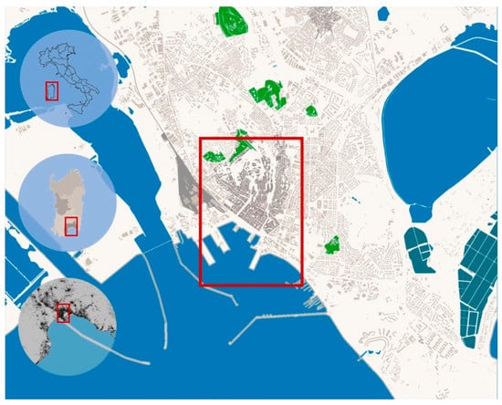
Figure 1.
The case study: Marina District in Cagliari, Italy. The figure is based on the editing via Geographic Information System (GIS) tools of data retrieved from the Territorial Information Systems of the Sardinia Region and of the City of Cagliari.
First, the Marina District (Figure 1) defines the Southern edge of the historical city and is the interface between the historical city, the contemporary city, and its infrastructural systems, and the waterfront [40,41,44]. More precisely, as the Gate of the City, Marina District represents a mediation structure between the historical port and the Acropolis, constituted by the Castello District. The Marina District, structured by the regular alignment of buildings along Roma Main Street and by the perspective axes generated by perpendicular streets (Baylle Street, Napoli Street, Porcile Street) relating the seaside and the Acropolis, is, thus, a central component of the distinctive image of the city of Cagliari. Furthermore, Marina is situated at the core of a system of cultural nodes, including the Municipal Palace, the regional council building, and the Manifattura Tabacchi (Figure 2). These nodes incorporate an exhibition space, a public art collection comprising sculptures and engravings by Costantino Nivola, which structures an articulated public space beneath the volume of the council chamber, and spaces for experimentation, innovation, and entrepreneurship in the sector of culture and creativity, respectively. Secondly, concerning social and demographic aspects, the Marina district is characterized by conditions associated with walkability. These include: (i) high population density equal to 12,258 in/km2, (ii) the diversity of functions and services, such as residential, political, and administrative functions, and commercial activities, encouraging a constant flow of people throughout the day; and (iii) the continuity of spaces partly or entirely closed to vehicular traffic [40,41].
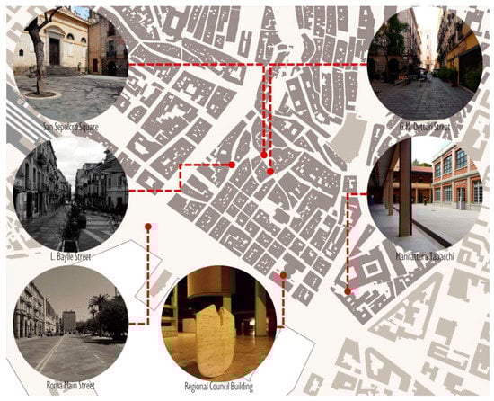
Figure 2.
The case study: relevant spaces and focal point of the Marina District, Cagliari.
In the following section, the results of the assessment of the sub-network of the most accessible routes are presented, and the usefulness of the selected cultural paths is analyzed.
4. Methodology
The proposed method combines space syntax techniques, geographic and spatial analytical tools, and qualitative indicators in a multi-criteria analysis framework that individuates segments comprising a network of cultural paths and assesses their usefulness. The utilization of spatial analysis techniques is an increasingly relevant aspect of research within the disciplinary fields of the conservation and valorization of the cultural heritage [45,46,47,48]. The methodology is articulated in five stages: (i) the selection and characterization of the case study; (ii) the identification of the tangible components of the cultural heritage; (iii) the individuation of the most central segments contiguous to significant cultural components; (iv) the definition of the network of cultural paths; (v) the data collection and calculation of indicators included in the cultural path assessment tool (PAST) (see Figure 3).
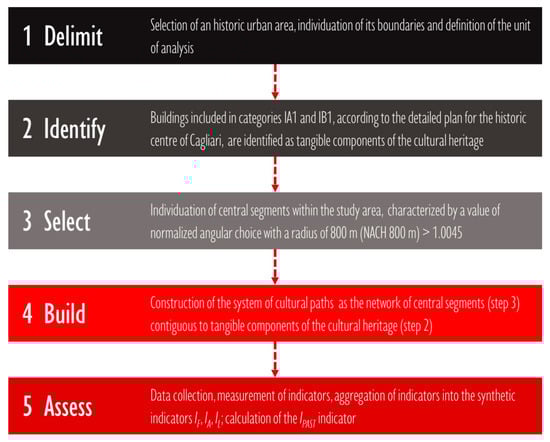
Figure 3.
Articulation of the five stages of the methodological framework.
The selection and characterization of the case study included identifying a historical urban area, establishing its boundaries, and defining the unit of analysis.
The unit of analysis was the street, individuated according to spatial continuity and toponyms. Significant cultural components were identified according to categories of cultural significance defined by the “Detailed Plan” for the historical center of Cagliari [44]. Cultural significance is defined as the sum of historic, aesthetic, scientific, social, and spiritual values embodied into a place [11]. According to this definition, urban elements included in categories within the framework of the detailed plan for the historical center of Cagliari were selected as significant tangible cultural components of the urban area. The categories IA1 and IB1, in fact, refer to buildings of cultural and historical relevance, whose typology, artistic, and architectural expressions, morphological attributes, and construction technologies are significant and worthy of preservation [44]. These buildings included monumental structures and buildings with specialized public or public interest functions, whose use and typological characteristics were strongly related to their historical and architectural attributes. Then, in stage three, the most central segments were identified by measuring the normalized angular choice with a radius of 800 m (NACH 800 m) and selecting paths across the Marina District with a NACH 800 m superior to the average measured value, equal to 1.0045. The normalized angular choice within an 800 m radius measured the probability that a path or a street segment was to be passed along the shortest routes from all spaces to all other spaces comprising a network within a 800 m radius from the analyzed space, Then, in stage four, the system of cultural paths was identified among the paths identified in stage three by utilizing topological analysis tools embodied in the QGis platform. Firstly, a 20 m buffer area was calculated around the most central paths; then, buffer areas overlapping significant cultural elements were identified. Lastly, in stage four, the street segments corresponding to the identified buffer areas were selected as the primary components of the network of cultural paths. Lastly, in stage five, selected paths were assessed via the cultural paths assessment tool (PAST) and the index of the usefulness of cultural paths was calculated. Data related to the distribution of collective transport nodes, topography, cultural heritage, and geometric characteristics, layout and design of street segments, and pedestrian surfaces were collected from the Territorial Information Systems of Sardinia and of the City of Cagliari, the open street map geographic database, street level imagery services, and satellite imagery services. The cultural paths assessment tool included qualitative and quantitative, spatial, and syntactic indicators, organized into three categories: (i) functional usability; (ii) accessibility; (iii) legibility (see Table 1). For each category, a synthetic indicator was determined by calculating the arithmetical average of the normalized values of the pertinent partial indicators.

Table 1.
Indicators and sub-indicators included in the cultural Paths ASsessment Tool (PAST).
The category indicators were then aggregated into an index of the usefulness of cultural paths (IPAST). The latter was calculated as the average of the values of the synthetic indicators of functional usability (IF), accessibility (IA), and legibility (IL) (Figure 3 and Figure 4).
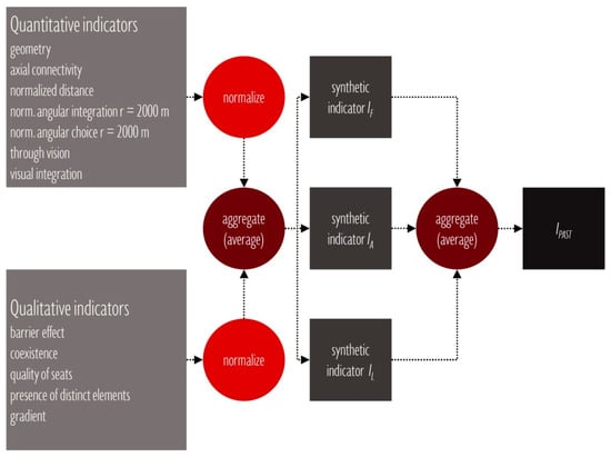
Figure 4.
Calculation of synthetic indicators and of the IPAST indicator.
The calculation of the IPAST index thus embodied a compensatory approach, where the overall effect of a deficiency referred to a specific property of a space could be mitigated by the advantages related to different attributes [15,16,17,19,22,40]. An index of usefulness for the whole network was then calculated as the average of the mean values of the indicators of functional usability (IF) and accessibility (IA) and of a weighted indicator of legibility (IL). The weighted indicator of legibility was calculated by multiplying the mean value of the indicator of legibility by a measure of intelligibility.
Further explanation is required for spatial and syntactic indicators. The indicator access to transport nodes was measured by calculating the shortest paths from a specific setting to all transit nodes.
For each analyzed setting, the set of shortest paths was determined via the point to layer network analysis tool. The center of the mass of each setting was set as the origin point and endpoints corresponding to transport nodes, and were grouped into a point-layer, which was set as the destination layer. The center of mass was determined via vector analysis tools by calculating the mean coordinates of the geometric feature representing the analyzed space.
For each path, a cost, corresponding to the distance, was measured. This cost value was then converted into a proximity variable conceptualized as the complement of the normalized cost. The latter was measured via a linear value function with pre-set minimum and maximum values. The maximum value was set at 800 m, and the minimum value was equal to 50 m. The maximum value corresponded to a significant distance utilized within the syntactic spatial analysis to investigate pedestrian natural movement [23,30,31]. On the other side, the minimum value was set to compensate for different factors, including: (i) errors in determining the position of destination points; (ii) tolerances set for the calculation of the shortest paths; (iii) effects of selecting the center of the mass of the analyzed space as the origin point of all paths. The normalized angular choice measured the through movement potential of a path. The normalized choice was calculated by dividing the choice value of a segment by its total depth. The resulting equation [23] was:
NACH = logCH + 1/logTD + 3
Normalized angular choice compensated the distortion on choice values determined by segregated patterns. Segregated designs, in fact, tended to determine an increase of total and average choice across the system. Normalized angular integration, on the other hand, measured the to-movement potential of a space, resulting from its distance, in terms of angular deviations, from other spaces in a system. The normalized variable measured the relationship between the optimization of travel distance embodied in an urban system and the cost of segregation determined by the size of the system itself. The resulting equation [23] was:
where NC is the node count and TD is the total depth of the i-th segment.
NAIN = NC^1.2/TD;
NACH (or normalised angular choice) and NAIN (or normalised angular integration) were calculated with a 2000-m radius. This value was identified as a significant distance for the study of pedestrian densities by Dhanani et al. [30].
Connectivity is a local configurational measure expressing the number of axial lines intersected by the analyzed line. For spaces represented by more than one geometrical feature, the value of the topological variables, angular choice, normalized angular integration, and connectivity were calculated as the average of the values measured for each related geometry.
With respect to legibility indicators, visual integration represented the visual distance from all nodes in the visibility graph to all others. Lastly, through vision was representative of the number of inter-visibility lines intersecting a node in a visibility graph. Thus, through vision was herein conceptualized as an indicator expressing the centrality of a space within a system [10,12,14,34,35,36].
The value of the visibility indicators considered for each space was calculated as the median of the values comprising the superior intervals that included 10% of the points in the grid covering the analyzed space. The origin points of the inter-visibility lines across a space were defined by a regular grid superimposed to the spatial layout. The grid resolution, determining the spatial interval among points, was set equal to 2 m. This measure resulted from the need to use a human-scale grid spacing, representative of the human usage of the environment and from the limits determined by the available computing capacity.
Partial indicators, synthetic indicators, and the usefulness index were expressed by a value ranging from 0 to 1, where 0 indicated the least condition and 1 the optimal condition of a space in terms of a specific environmental determinant of usefulness. For each index, measures of central tendency (mean and median) and measures of dispersion (standard deviation, inter-quartile range) were calculated (See Table 2).
Table 2.
Values of the Indicators IF, IA, IL, and IPAST.
Quantitative partial indicators were normalized via value functions based on the fuzzy logic principle [16]. Fuzzy logic expresses the degree of truth of a statement related to a condition of an element as a value ranging from 0 to 1, where 0 indicates that the analyzed condition is not verified by the element, 1 indicates that the analyzed condition is completely satisfied by the element, and an intermediate value indicates that the analyzed condition is partially satisfied. Hence, value functions convert the value of an indicator in a value ranging from 0 to 1 in relation to pre-set minimum and maximum values. With respect to qualitative indicators, for each variable, an assessment scale ranging from 0 to 1 was determined. Each value within the scale was associated with a pre-defined observable condition [15,17,19,23,40,49,50].
5. Results
The assessment of the network of cultural paths within the historical district of Marina underlined acceptable levels of usefulness. The values of the index of the usefulness of cultural paths (IPAST), in fact, ranged from a minimum of 0.43 determined for Giovanni Maria (G.M.) Dettori Square, corresponding to a condition of inadequate usefulness, to a maximum of 0.74 measured for Roma Street, thus, indicating good quality of the public space. More precisely, three paths were assessed as inadequate, thus, characterized by an IPAST lower than 0.50, fourteen paths as adequately useful, with values of the IPAST ranging from 0.51 to 0.65, and two as good, with values of IPAST ranging from 0.66 to 0.85. With respect to measures of central tendency, the mean was equal to 0.58 and the median to 0.60. On the other hand, indicators of dispersion, including standard deviation and interquartile range, were equal to 0.07 and 0.12, respectively, thus, indicating the homogeneity of the paths analyzed in terms of usefulness (see Table 2 and Figure 5).
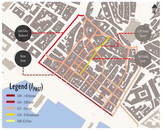
Figure 5.
Distribution of values of the IPAST indicator across the network of cultural paths.
With respect to the synthetic indicator of usability (IF), the analysis revealed conditions ranging from inadequate for Regina Margherita Main Street, with an IF equal to 0.45, to good, for G.M Dettori Street, with an IF equal to 0.85. More precisely, five paths had scores less than or equal to 0.50, corresponding to inadequate conditions of usability, six had values ranging from 0.51 to 0.65, indicating the acceptable usability of the public space, and eight presented values included in the interval 0.66 to 0.85, corresponding to good usability of the public space. With respect to central tendency measures, the mean was equal to 0.62 and the median to 0.65, thus, indicating a general acceptable usability of the spaces comprising the network of cultural paths. On the other hand, the Inter-quartile range (IQR), equal to 0.20, and the standard deviation, equal to 0.12, represented a relevant difference among the analyzed spaces in terms of embodied opportunities for meaningful actions (see Figure 6).
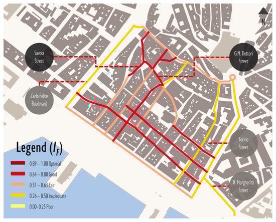
Figure 6.
Distribution of values of the IF indicator across the network of cultural paths.
The results also presented adequate conditions of accessibility, measured by the IA indicator, underlined by the mean equal to 0.64, and the median, equal to 0.63. The minimum value was equal to 0.54, representing adequate quality, and it was calculated for Del Collegio Street (see Figure 7).
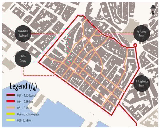
Figure 7.
Distribution of values of the IA indicator across the network of cultural paths.
The maximum was equal to 0.84 and it was calculated for Roma Main Street. The latter, thus, could easily be reached by means of public transit. In general terms, 15 paths were adequately accessible, and four were significantly accessible. The interquartile range and the standard deviation, equal to 0.07, revealed marginal differences across the analyzed spaces in the topological and spatial attributes related to accessibility. Within the category of accessibility, an interesting finding concerned the indicators’ angular segment integration and angular segment choice. The former underlined the adequate relevance of the cultural paths as a destination within a 2000 m radius. The mean was equal to 0.61, and the observed values ranged from 0.47, corresponding to a limited accessibility, measured for G. M. Dettori Street, to 0.81, measured for Roma Street and corresponding to good accessibility.
The values of the interquartile range (=0.10) and standard deviation (=0.09) revealed a significant homogeneity in terms of structural importance within the spatial layout among the analyzed paths. The angular segment choice, on the other hand, revealed that the analyzed paths presented elevated betweenness centrality. The mean was equal to 0.77, corresponding to relevant through-movement potential, and the observed values ranged from 0.69, measured for L. Baylle Street, to 0.95, measured for G. Manno Street, indicating pre-eminent centrality. Furthermore, the interquartile range, equal to 0.08, and standard deviation, equal to 0.07, revealed that the selected set of cultural paths formed a homogeneous secondary network of paths, delimited by four central streets—Roma Street, Carlo Felice Boulevard, Manno Street, and Regina Margherita Boulevard—that were likely to maximize natural movement.
Lastly, the legibility of the selected cultural paths was inadequate, with a mean value of the indicator of legibility equal to 0.49 and a median equal to 0.52. More precisely, the observed values ranged from 0.26, representative of an inadequate imageability of the setting, measured for G. M. Dettori Square, to 0.83 measured in Roma Street and in Carlo Felice boulevard, indicating a legible environment (see Figure 8).
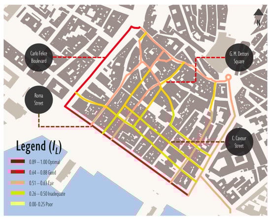
Figure 8.
Distribution of values of the IL indicator across the network of cultural paths.
Nine paths presented values of the legibility indicator comprised in the interval 0.26–0.50, indicating an inadequately legible environment, eight spaces were adequately legible and presented values of the index of legibility (IL ) comprised in the interval 0.51 to 0.65, and two present IL values comprised in the interval 0.66 to 0.85, indicating a structured and vividly identified spatial layout. With respect to measures of dispersion, the standard deviation, equal to 0.16, and the interquartile range, equal to 0.25, indicated a significant difference across the network of cultural paths in the topological, morphological, and functional attributes related to legibility.
In particular, the visual integration indicator revealed an average condition of limited integration (mean equal to 0.41). The values observed a range from 0.10, indicating a segregated space measured for Torino Street, to 0.9, measured for Roma Street and Carlo Felice Boulevard, indicating an integrated space. Measures of dispersion—particularly standard deviation—equal to 0.20 indicated a significant heterogeneity in terms of visual distance from each path to all other spaces within the system.
Finally, the correlation between local and global configurational properties was moderate (R2 = 0.52) and determined the intelligibility of the network of cultural paths. Local properties were measured by axial connectivity, while global properties were expressed in terms of axial integration. The index of usefulness for the whole network (IPAST Global) was equal to 0.50, thus, indicating a general adequate quality of the network of culturally significant paths.
In the following section, the results obtained from the application of the PAST are thoroughly discussed, and the most relevant criticalities, along with pertinent high-leverage interventions, are identified.
6. Discussion
The results presented in the previous section underline different issues and objectives for interventions of urban renewal and regeneration aimed at increasing the usefulness of the culturally relevant paths and their structural importance as tools that organize the image of the historical urban landscape. With respect to the usability dimension, two frequent criticalities are observed: the spatial competition between outdoor individual and collective practices and vehicular flows, particularly along secondary paths; and the inadequacy of public space seating. Good seating, lighting, and high-quality landscaping encourage informal/stationary activity and embody central affordances for resting and for engaging with the public space, particularly for the elderly. As observed by Gehl [21], comfort, distribution, and the prospect of primary seats affect people’s propensity to stay in a space. In particular, seats positioned along structured spatial boundaries offer a repaired space and a microclimatic niche and afford the observation of the distinct, unique elements of the urban landscape, or engagement with activities across the public space. This pattern of affordances is thus central to the quality of a seat and to the likelihood of people utilizing it. Nevertheless, primary seats in the area of study were few, distant from active façades, not supported by the border effect engendered by the closeness to structured edges, nor enriched by the opportunities to observe outdoor individual or collective practices or interesting scenery [20].
Furthermore, the conflict between outdoor activities and vehicular flows and the morphology of secondary, segregated paths urges for a different layout of the street space based on two criteria: reducing the presence of vehicles and shaping a robust and minimal space that multiplies the opportunities for different practices and spatial appropriation.
With respect to the accessibility dimension, the limited connectivity emerges as the most relevant weakness, limiting possibilities of choosing between alternative routes. The aspect of connectivity is associated by Jane Jacobs [51] to the capillary spatial distribution of collective practices, services, and economic opportunities, which results in a permeable structure from the multiplication of points of intersection among paths of people moving towards different destinations. In general terms, the improvement of connectivity would result in increased accessibility across the spatial layout and, thus, in reinforcing the integration of segregated street segments and public spaces within the network of cultural paths. Furthermore, the compact structure of the Marina District and, thus, its limited permeability, limit the possibility for a project of the void aimed at increasing the permeability of the urban structure [52]. Increasing permeability, in turn, engenders a process of grid-intensification, which determines increased inter-accessibility, and, consequently, reinforces the relevance of a location as a center, and its capacity to accommodate inter-dependent activities [35,53]. Finally, with regard to the legibility dimension, the results underline the visual segregation and marginal centrality of paths comprising the background network, delimited by the ring of integrated and legible paths. Consequently, the utilization of symbolic tools at decision points [8] and the reinforcement of the identity and continuity of spaces could improve the legibility of segregated streets and the capacity of the network of cultural paths to produce a coherent, functional, and vividly identified image of the urban landscape. Decision points can be identified via visual analysis by measuring the clustering coefficient within a visibility graph. In this type of graph, each node corresponds to a location in a space and each arc to a relation of inter-visibility [30,54]. The clustering coefficient calculates the degree to which two points visible from a location are themselves inter-visible. Low values of the clustering coefficient identify junctions or decision points—thus, locations where visual information changes significantly.
Furthermore, the identity and continuity of a path can be reinforced by emphasizing the directional adjectivization determined by a gradient, by organizing sequences, by inserting distinct elements, or by strengthening terminal points. A gradient is defined as a regular change in an attribute, which intensifies along a direction. Furthermore, regular sequences of architectural elements or the continuity of surface material and textures can reinforce the legibility of a path, while distinct elements and landmarks can support spatial navigation, reinforcing the decision point and establishing confirmation signs [8]. Distinct elements are defined as elements characterized by a unique and memorable attribute differentiating them from the context. The uniqueness of an element is determined by intelligible, non-regular shape, spatial pre-eminence and by figure-ground tension.
In general terms, the results underline the need to project the relationship between the layout of the public open space and individual and collective practices, emphasizing the conceptualization of the public space as an infrastructure supporting different meaningful experiences and behaviors. This objective implies a spatial design based on concepts of complexity and void. Complexity entails an inclusive and unifying structure that encompasses attributes of heterogeneity and ambiguity, conducive to contradictory and pluralistic practices, and attributes of identity and structure determining functional and vividly individuated images of the environment conducive to the simplified and extended grasp of sense on the context and to the experience of emotional connection [8,55,56]. The concept of void refers to a collection of heterogeneous spaces across scales, which includes leftovers, infrastructure, natural areas, and open spaces, and is central to an architectural project of the public space summarized in the concept of the project of the ground. The ground is thus conceptualized as a thick and plastic material that can be shaped to produce heterogeneous and contiguously connected spatial situations, establishing the physical support for different individual and collective practices [57,58]. The ambiguity and indeterminateness of the public space thus emerge as central characteristics, embodying opportunities for people to invent different forms of coexistence and comfort.
In the subsequent section, the findings of the presented study are summarized and a perspective for the development of the research is outlined.
7. Conclusions
The analysis of the case study indicates that the theoretical and methodological framework embodied in the PAST can support the urban planning and design process in two ways: (i) individuating a network of culturally relevant paths that connect significant elements of the historical urban landscape; (ii) identifying criticalities and high-leverage interventions for enhancing the usefulness of cultural paths. Hence, PAST addresses the need for analytic frameworks that support decision-making processes by identifying and measuring environmental variables that affect individual behavior and collective practices.
In particular, the methodological framework addresses two aspects central to the analysis of the quality of the public space: the combination of qualitative and spatial and topological quantitative indicators; and the combination of indicators measuring intrinsic and extrinsic attributes of spaces within a multi-criteria analysis framework. This approach operationalizes the quality of the public space—hence, its potential to affect individual and collective practices—as the product of different variables: composition, the functional organization of spaces, the organization of the collective transport system, identity, structure, and the configuration of the spatial structure of the city.
Nevertheless, the future development of the methodological framework will address three criticalities that emerged during this initial research. The first issue concerns weighting the indicators and sub-indicators according to their context-specific relative importance. The latter depends on the specific behavior selected as the dependent variable within the model and on individual and socio-economic factors characterizing the case study. Consequently, the methodological framework will encompass decision-making techniques based on the analytic hierarchy process (AHP) for engaging stakeholders in complex decisions related to the selection and prioritization of environmental variables and pertinent indicators.
The second aspect concerns the analysis of the co-relation between measures of usefulness obtained from the PAST and actual patterns of movement and co-presence across the public space. Consequently, the methodological framework will encompass a validation stage for investigating patterns of individual and collective practices and experiences. By analyzing the data collected from map-based surveys conducted via a public participation geographic information system (PPGIS) and volunteered geographic information (VGI) tools.
Consequently, the modular structure of the methodological framework, along with the utilization of AHP techniques and PPGIS tools for understanding the patterns of individual and collective practices and for strengthening public participation, will allow for the adaptation of the proposed methodology in the analysis of spatial practices across different contexts, while enhancing the relevance, predictiveness, and validity of the index of usefulness, and empowering citizens to co-create the city. In this respect, an improved PAST tool could establish a relevant framework for strengthening urban policy, governance and planning actions, and decision-making processes by offering insight into the compositional, topological, and functional attributes of the physical environment affecting behaviors and idiorrhythms of subjects belonging to different urban populations [52,55,59].
Author Contributions
This paper is the result of the joint work of the authors. In particular, “Literature Review on the Concepts of Usability, Accessibility, and Legibility,” “Methodology,” “Results,” and “Discussion” were written jointly by the authors. C.G. wrote “Introduction.” A.A. wrote “Selection of the case study.” C.Y. wrote “Conclusions.” All authors have read and agreed to the published version of the manuscript.
Funding
This study was supported by the MIUR (Ministry of Education, Universities and Research (Italy)) through a project entitled WEAKI TRANSIT: WEAK-demand areas Innovative TRANsport Shared services for Italian Towns (Project protocol: 20174ARRHT_004; CUP Code: F74I19001290001), financed with the PRIN 2017 (Re-search Projects of National Relevance) program. We authorize the MIUR to reproduce and distribute reprints for governmental purposes, notwithstanding any copyright notations thereon. Any opinions, findings, and conclusions or recommendations expressed in this material are those of the authors, and do not necessarily reflect the views of the MIUR. This study was also supported by the project “Space Syntax and Multicriteria Analysis for the Measurement of Walkability in the Build Environment,” founded by the program “Bando 2019 Mobilità Giovani Ricercatori (MGR),” financed by the Autonomous Region of Sardinia (under the Regional Law of 7 August 2007, n. 7 “Promotion of Scientific Research and Technological Innovation in Sardinia”).
Conflicts of Interest
The authors declare no conflict of interest.
References
- UNESCO Recommendation on the Historic Urban Landscape. Available online: https://whc.unesco.org/uploads/activities/documents/activity-638-98.pdf (accessed on 3 March 2020).
- Ewing, R.; Hajrasouliha, A.; Neckerman, K.M.; Purciel-Hill, M.; Greene, W.H. Streetscape Features Related to Pedestrian Activity. J. Plan. Educ. Res. 2015, 36, 5–15. [Google Scholar] [CrossRef]
- Ewing, R.; Handy, S. Measuring the Unmeasurable: Urban Design Qualities Related to Walkability. J. Urban Des. 2009, 14, 65–84. [Google Scholar] [CrossRef]
- Hernández, M.G.; De La Calle-Vaquero, M.; Yubero, C. Cultural Heritage and Urban Tourism: Historic City Centres under Pressure. Sustainability 2017, 9, 1346. [Google Scholar] [CrossRef]
- May, D.E. Rethinking the conflict between landscape change and historic landscape preservation. J. Heritage Tour. 2015, 11, 1–5. [Google Scholar] [CrossRef]
- Jansen-Verbeke, M. The territoriality paradigm in cultural tourism. Turyzm 2009, 19, 25–31. [Google Scholar] [CrossRef]
- Russo, A.P. The “vicious circle” of tourism development in heritage cities. Ann. Tour. Res. 2002, 29, 165–182. [Google Scholar] [CrossRef]
- Lynch, K. The Image of the City; MIT press: Cambridge, USA, 1960; Volume 11. [Google Scholar]
- Alexandridis, G.; Chrysanthi, A.; Tsekouras, G.E.; Caridakis, G. Personalized and content adaptive cultural heritage path recommendation: An application to the Gournia and Çatalhöyük archaeological sites. User Model. User-Adapted Interact. 2019, 29, 201–238. [Google Scholar] [CrossRef]
- Zaninović, T.; Palaiologou, G.; Šćitaroci, B.B.O. Walkspace as Cultural Heritage Within Urban Landscape; Springer Science and Business Media LLC: Cham, Switzerland, 2019; pp. 263–288. [Google Scholar]
- Australia International Council on Monuments and Sites. The Burra Charter: The Australia ICOMOS Charter for Places of Cultural Significance 2013; Australia ICOMOS Incorporated: Burwood, Australia, 2013; ISBN 0-9578528-4-3. [Google Scholar]
- Jorgensen, B.S.; Stedman, R.C. A comparative analysis of predictors of sense of place dimensions: Attachment to, dependence on, and identification with lakeshore properties. J. Environ. Manag. 2006, 79, 316–327. [Google Scholar] [CrossRef]
- Min, B.; Lee, J. Children’s neighborhood place as a psychological and behavioral domain. J. Environ. Psychol. 2006, 26, 51–71. [Google Scholar] [CrossRef]
- McCunn, L.J.; Gifford, R. Spatial navigation and place imageability in sense of place. Cities 2018, 74, 208–218. [Google Scholar] [CrossRef]
- Garau, C.; Annunziata, A. Smart City Governance and Children’s Agency: An Assessment of the Green Infrastructure Impact on Children’s Activities in Cagliari (Italy) with the Tool “Opportunities for Children in Urban Spaces (OCUS)”. Sustainability 2019, 11, 4848. [Google Scholar] [CrossRef]
- Jabbari, M.; Fonseca, F.; Ramos, R. Combining multi-criteria and space syntax analysis to assess a pedestrian network: The case of Oporto. J. Urban Des. 2017, 23, 23–41. [Google Scholar] [CrossRef]
- Moura, F.; Cambra, P.; Gonçalves, A.B. Measuring walkability for distinct pedestrian groups with a participatory assessment method: A case study in Lisbon. Landsc. Urban Plan. 2017, 157, 282–296. [Google Scholar] [CrossRef]
- García, R.T.; Lara, J.A.S. Q-PLOS, developing an alternative walking index. A method based on urban design quality. Cities 2015, 45, 7–17. [Google Scholar] [CrossRef]
- Blečić, I.; Cecchini, A.; Congiu, T.; Fancello, F.; Fancello, G.; Trunfio, G. Walkability Explorer: Application to a Case-Study. In Proceedings of the International Conference on Computational Science and Its Applications—ICCSA 2015, Banff, AB, Canada, 22–25 June 2015; Gervasi, O., Murgante, B., Misra, S., Gavrilova, M.L., Rocha, A.M.A.C., Torre, C., Taniar, D., Apduhan, B.O., Eds.; Springer International Publishing: Cham, Switzerland, 2015; pp. 758–770. [Google Scholar]
- Gehl, J. Cities for People; Island Press: Washington, DC, USA, 2013; ISBN 1-59726-984-0. [Google Scholar]
- Gehl, J. Public spaces for a changing public life. In Open Space: People Space; Taylor & Francis: Oxon RN, UK, 2007; pp. 23–30. [Google Scholar]
- Garau, C.; Annunziata, A.; Yamu, C. A walkability assessment tool coupling multi-criteria analysis and space syntax: The case study of Iglesias, Italy. Eur. Plan. Stud. 2020. Available online: https://www.tandfonline.com/doi/abs/10.1080/09654313.2020.1761947 (accessed on 24 May 2020). [CrossRef]
- Yamu, C.; Van Nes, A. An Integrated Modeling Approach Combining Multifractal Urban Planning with a Space Syntax Perspective. Urban Sci. 2017, 1, 37. [Google Scholar] [CrossRef]
- Omer, I.; Jiang, B. Imageability and Topological Eccentricity of Urban Streets. In Geospatial Analysis and Modelling of Urban Structure and Dynamics; Jiang, B., Yao, X., Eds.; Springer Netherlands: Dordrecht, The Netherlands, 2010; pp. 163–175. [Google Scholar]
- Yun, Y.W.; Kim, Y.O. The effect of depth and distance in spatial cognition. In Proceedings of the 6th International Space Syntax Symposium, Istanbul, Turkey, 12–15 June 2007. [Google Scholar]
- Hillier, B. Space is the machine: A configurational theory of architecture; Space Syntax, UCL: London, UK, 2007. [Google Scholar]
- Hillier, B.; Burdett, R.; Peponis, J.; Penn, A. Creating life: Or, does architecture determine anything? Archit. Comport./Archit. Behav. 1986, 3, 233–250. [Google Scholar]
- Yamu, C. It Is Simply Complex(ity). disP Plan. Rev. 2014, 50, 43–53. [Google Scholar] [CrossRef]
- Vaughan, L. The spatial syntax of urban segregation. Prog. Plan. 2007, 67, 205–294. [Google Scholar] [CrossRef]
- Al-Sayed, K. Space Syntax Methodology; Bartlett School of Architecture, UCL: London, UK, 2014. [Google Scholar]
- Turner, A.; Doxa, M.; O’Sullivan, D.; Penn, A. From Isovists to Visibility Graphs: A Methodology for the Analysis of Architectural Space. Environ. Plan. B: Plan. Des. 2001, 28, 103–121. [Google Scholar] [CrossRef]
- Geurs, K.; Van Wee, B. Accessibility evaluation of land-use and transport strategies: Review and research directions. J. Transp. Geogr. 2004, 12, 127–140. [Google Scholar] [CrossRef]
- Hillier, B.; Iida, S. Network effects and psychological effects: A theory of urban movement. In Proceedings of the 5th International Symposium on Space Syntax, Delft, The Netherlands, 13–17 June 2005; Technical University Delft: Delft, The Netherlands, 2005; Volume 1, pp. 553–564. [Google Scholar]
- van Nes, A.; Yamu, C. Space Syntax: A method to measure urban space related to social, economic and cognitive factors. In The Virtual and the Real in Planning and Urban Design; Routledge: New York, NY, USA, 2017; pp. 136–150. [Google Scholar]
- Hillier, B. Spatial Sustainability in Cities: Organic Patterns and Sustainable Forms; Royal Institute of Technology (KTH): Stockholm, Sweden, 2009. [Google Scholar]
- Hillier, B.; Penn, A.; Hanson, J.; Grajewski, T.; Xu, J. Natural movement: Or, configuration and attraction in urban pedestrian movement. Environ. Plan. B Plan. Des. 1993, 20, 29–66. [Google Scholar] [CrossRef]
- Dhanani, A.; Tarkhanyan, L.; Vaughan, L. Estimating pedestrian demand for active transport evaluation and planning. Transp. Res. Part A Policy Pract. 2017, 103, 54–69. [Google Scholar] [CrossRef]
- Bielik, M.; König, R.; Schneider, S.; Varoudis, T. Measuring the Impact of Street Network Configuration on the Accessibility to People and Walking Attractors. Netw. Spat. Econ. 2018, 18, 657–676. [Google Scholar] [CrossRef]
- Ozbil, A.; Gurleyen, T.; Yesiltepe, D.; Zunbuloglu, E. Comparative Associations of Street Network Design, Streetscape Attributes and Land-Use Characteristics on Pedestrian Flows in Peripheral Neighbourhoods. Int. J. Environ. Res. Public Heal. 2019, 16, 1846. [Google Scholar] [CrossRef]
- Garau, C.; Annunziata, A.; Coni, M. A Methodological Framework for Assessing Practicability of the Urban Space: The Survey on Conditions of Practicable Environments (SCOPE) Procedure Applied in the Case Study of Cagliari (Italy). Sustainability 2018, 10, 4189. [Google Scholar] [CrossRef]
- Annunziata, A.; Garau, C. Understanding Kid-Friendly Urban Space for a More Inclusive Smart City: The Case Study of Cagliari (Italy). In Proceedings of the International Conference on Computational Science and Its Applications—ICCSA 2018, Melbourne, VIC, Australia, 2–5 July 2018; Gervasi, O., Murgante, B., Misra, S., Stankova, E., Torre, C.M., Rocha, A.M., Taniar, D., Apduhan, B.O., Tarantino, E., Ryu, Y., Eds.; Springer Science and Business Media LLC: Cham, Switzerland, 2018; pp. 589–605. [Google Scholar]
- Garau, C.; Ilardi, E. The “Non-Places” Meet the “Places:” Virtual Tours on Smartphones for the Enhancement of Cultural Heritage. J. Urban Technol. 2014, 21, 79–91. [Google Scholar] [CrossRef]
- Garau, C. From Territory to Smartphone: Smart Fruition of Cultural Heritage for Dynamic Tourism Development. Plan. Pract. Res. 2014, 29, 238–255. [Google Scholar] [CrossRef]
- Municipality of Cagliari Piano Particolareggiato per il Centro storico, progetti strategici per lo spazio Pubblico. Available online: https://www.comune.cagliari.it/portale/resources/cms/documents/Etg014.pdf (accessed on 4 April 2020).
- Abou Diwan, G. GIS-Based comparative archaeological predictive models: A first application to iron age sites in the Bekaa (Lebanon). Mediterr. Archaeol. Archaeom. 2020, 20, 143–158. [Google Scholar]
- Kaimaris, D. Ancient theaters in Greece and the contribution of geoinformatics to their macroscopic constructional features. Sci. Cult. 2018, 4, 9–25. [Google Scholar]
- Hatzopoulos, J.N.; Stefanakis, D.; Georgopoulos, A.; Tapinaki, S.; Pantelis, V.; Liritzis, I. Use of various surveying technologies to 3d digital mapping and modelling of cultural heritage structures for maintenance and restoration purposes: The tholos in Delphi, Greece. Mediterr. Archaeol. Archaeom. 2017, 17, 311–336. [Google Scholar]
- Smith, N.; Levy, T. ARCHFIELD: A digital application for real-time acquisition and dissemination--from the field to the virtual museum. Mediterr. Archaeol. Archaeom. 2014, 14, 65–74. [Google Scholar]
- Saelens, B.E.; Handy, S.L. Built Environment Correlates of Walking. Med. Sci. Sports Exerc. 2008, 40, S550–S566. [Google Scholar] [CrossRef] [PubMed]
- Clifton, K.J.; Smith, A.D.L.; Rodríguez, D.A. The development and testing of an audit for the pedestrian environment. Landsc. Urban Plan. 2007, 80, 95–110. [Google Scholar] [CrossRef]
- Jacobs, J. The Death and Life of Great American Cities; Wiley: Hoboken, NJ, USA, 2015; pp. 94–109. [Google Scholar]
- Secchi, B. Prima Lezione di Urbanistica; Gius. Laterza & Figli Spa: Bari, Italy, 2011. [Google Scholar]
- Yamu, C. Eine multifraktale Planungsmethode für eine nachhaltige Stadt- und Regionalentwicklung. In Jahrbuch Raumplanung. Technische Universität Wien. Band 1; Bröthaler, J., Getzner, M., Giffinger, R., Hamedinger, A., Voigt, A., Eds.; NWV Verlag: Vienna, Austria, 2013. [Google Scholar]
- Turner, A. To move through space: Lines of vision and movement. In Proceedings of the 6th International Space Syntax Symposium, Istanbul, Turkey, 12–15 June 2007; p. 037. [Google Scholar]
- Urban Ethics in the Anthropocene The Moral Dimensions of Six Emerging Conditions in Contemporary Urbanism, 1st ed.; Palgrave Macmillan: Singapore, 2019.
- Venturi, R.; Stierli, M.; Brownlee, D.B. Complexity and Contradiction in Architecture; The Museum of Modern Art: New York, NY, USA, 1977; Volume 1. [Google Scholar]
- Russi, N. Background, Il Progetto del Vuoto; Quodlibet: Macerata, Italy, 2019. [Google Scholar]
- Viganò, P. I Territori Dell’urbanistica: Il Progetto Come Produttore di Conoscenza; Officina edizioni: Rome, Italy, 2010; ISBN 88-6049-077-4. [Google Scholar]
- Secchi, B. La Città dei Ricchi e la Città dei Poveri; Gius. Laterza & Figli Spa: Bari, Italy, 2013. [Google Scholar]
© 2020 by the authors. Licensee MDPI, Basel, Switzerland. This article is an open access article distributed under the terms and conditions of the Creative Commons Attribution (CC BY) license (http://creativecommons.org/licenses/by/4.0/).