Article

Evolution of Energy Landscapes: A Regional Case Study in the Western Netherlands

1
Landscape Architecture Chair Group, Environmental Sciences, Wageningen University, 6708 PB Wageningen, The Netherlands
2
Urban Synergy, 3032 BG Rotterdam, The Netherlands
3
Academy of Architecture, Amsterdam University of the Arts, 1011 PG Amsterdam, The Netherlands
*
Author to whom correspondence should be addressed.
Sustainability 2020, 12(11), 4554; https://doi.org/10.3390/su12114554
Submission received: 26 February 2020 / Revised: 20 May 2020 / Accepted: 25 May 2020 / Published: 3 June 2020
(This article belongs to the Section Sustainable Urban and Rural Development)

Abstract

:
While the transition to renewable energy becomes a main driver of landscape change, few publications discuss the historical transformation of landscapes for the development of energy—commonly referred to as energy landscape. The research reported in this paper investigates the evolution of energy landscapes in the Western Netherlands—a region shaped by peat extraction and dotted with windmills. Five periods have been identified, dominated by wood, peat, wind, fossil fuels, and modern renewables, respectively. During each period, the landscape coevolved with the new energy source hosting new energy infrastructure. The sequence of landscape transformations over the past 10 centuries in the Western Netherlands is illustrated by means of historical paintings, photographs and a series of five georeferenced maps. Our systematic analysis confirms the long-lasting and manifold interrelations between energy development and landscape transformation at the brink of another energy transition. This paper presents the first all-encompassing application of the analytical framework for the study of energy landscapes proposed earlier. The three main qualifications—substantive, spatial, and temporal—provided a clear framework for the systematic study of landscape transformations at the regional scale.

1. Introduction

While the etymology of ‘landscape’ remains a scholarly pursuit to those that question the ontological ties between the English term and the Dutch landschap, most of us will fall silent when standing across the impressive landscape paintings from the Dutch Golden Age. Few of us can think of The Netherlands without picturing their historical windmills, first recorded by the artist Jacob van Ruisdael and his contemporaries in the 17th century. Times have changed considerably. The public support for advanced wind turbines in The Netherlands and other countries is limited—a function of demographic characteristics, concern for climate change, and geographical location [1]. Yet, we are starting to comprehend that the landscapes we dwell, work, and recreate in will be transformed by the transition to renewable energy [2,3]. Anyhow, landscape transformation for the sake of energy is not a new phenomenon. Large-scale deforestation, for example, was common in societies that relied on firewood [4,5]. Scholars have been stressing the importance for research on the interrelations between ‘energy’ and ‘landscape’ and, more recently, the need to study the history of energy landscapes (see, e.g., [6,7,8]).
For the largest part of history, humankind relied on renewable energy sources such as wood and wind. Those were followed by fossil fuels: coal, natural gas, and oil. The period of change from one main energy source to another is commonly referred to as energy transition, often entailing but not limited to technological innovation, socioeconomic changes, and environmental transformations (see, e.g., [9]). Sustainable energy transition refers to the most recent shift from fossil fuels to renewable energy sources motivated by, among others, climate change [10].
While past energy transitions are well understood with regards to technological innovation and socioeconomic changes, few publications address the large-scale landscape transformations that took place. Silvia Crowe—one of the first scholars in energy landscape research—stressed about 60 years ago: “The superficial approach to a landscape, seeing only its appearance at the moment, without realizing its past, its essential character or its potential future, can have a stultifying effect at the time we need a broad-minded vision. The humanized landscape is a constantly changing pattern, and cannot be arrested at one point in history.” [11] (p. 38). Crowe’s depiction of the dynamic and ever-changing character of landscape, along with the present-day renaissance of renewable energy [7], calls for a better understanding of historical landscape change. Marc Antrop draws a direct link between understanding the past and envisioning the future: “past traditional landscapes and the manifold relations people have towards the perceivable environment and the symbolic meaning it generates, offer valuable knowledge for more sustainable planning and management for future landscapes” [12] (p. 21). Environmental designers and others illustrated that the layering of historical patterns onto geoscientific patterns provides clues for sustainable spatial planning (e.g., [13]).
Several scholarly studies on the historical development of energy provided the foundations for the research presented in this paper. In 1994, Smil discussed the fundamental role of energy in world history [4]. In 2001, Sieferle wrote about different ‘energy systems’ and described them in relation to social evolutions [5]. In the same year, Verbong et al. examined the Dutch history of modern renewables [14]. Noorman and De Roo [15] and Van Kann [16] took a look at historical landscape transformation in The Netherlands, with a focus on renewable energy. Although publications stress that energy developments have had large-scale effects on the landscape (e.g., [17,18]), the spatiotemporal characteristics of those energy landscapes have not yet been studied in detail.
The term ‘energy landscape’ may have different meanings. Blaschke et al. remind us that “the concept of an energy landscape like the landscape concept in general may appear vague and difficult to grasp, being viewed from different perspectives by different disciplines.” [17] (p. 9). Goshn refers to ‘energy landscape’ as landscape of energy extraction [19]. Lambussiere and Nadai [20], Nadai and Van der Horst [21], and Maxwell [22] take a broader perspective and describe their object of study as ‘landscape of energy/energies.’ Others focus on particular kinds of energy landscapes such as ‘sustainable energy landscapes’ [23], ‘landscapes of carbon neutrality’ [24], ‘third generation energy landscapes’ [15], and ‘energy landscapes of the sustainable economy’ [6]. Recently, Pasqualetti and Stremke have put forward a more encompassing definition of energy landscapes which we embraced in the research presented in this paper: “observable landscapes that originate directly from the human development of energy resources” [25] (p. 98).
The objective of the research presented in this paper was to map the evolution of energy landscapes in space and time, by means of a case study. The geographical focus is the region of the Western Netherlands—an archetypical peat area. The following research question has been pursued by means of expert interviews, literature study, and map analysis: What energy landscapes have evolved in the Western Netherlands and how can they be characterized with regard to energy source, spatial appearance and temporality?

2. Conceptual Framework

In the following, we will first introduce the historical energy periods that allow ‘locating’ the transformation of particular Dutch landscapes in time. Secondly, we present a synthesis of the literature discussing the different types of energy sources. Thirdly, we summarize the three qualifications for the characterization of energy landscapes proposed by Pasqualetti and Stremke [25].

2.1. Historical Energy Periods

The portion of time dominated by a certain energy source is commonly referred to as energy period. The boundaries between periods are somewhat fuzzy because most energy transitions are gradual transformations of existing systems [26]. While particular energy sources may have shaped the energy landscape of a period, energy scholar Vaclav Smil pointed out that “… none (energy transition) has ever resulted in complete domination by a single energy source” [27] (p. 224).
For the purpose of this paper, we start from a set of well-established main periods of Dutch history. Table 1 provides an overview of those historical periods (upper row), two sets of energy periods discussed in the literature, and the five energy periods defined during our research (lowest row). Within the period of “organic economy” [6] or “1st generation energy landscapes” [15], three distinct energy periods can be differentiated for the Western Netherlands: the periods of ‘wood energy,’ ‘peat energy,’ and ‘wind energy.’ Although peat extraction in the Western Netherlands started during the Early Middle Ages [28], we refer to the Middle Ages (starting around 1000) as the ‘period of peat energy.’ This is due to the fact that the large-scale peat extraction in the region was part of the larger ‘extraction movement’ in Western Europe. This period—between 1000 and 1300—is also referred to as the ‘Grote Ontginning’ (‘The Great Exploitation’) [29]. Period 4 (industrialization) and period 5 (post-industrial) are dominated by fossil fuels and modern renewables, respectively.
While the above five energy periods are defined according to the main energy source, this does not mean that the use of other sources ceased to exist. While the energy source responsible for major landscape transformation changed, for example from peat to wind, some functions such as room heating were still fueled by peat.

2.2. General Types of Energy Sources and Landscapes Distinguished in the Literature

The literature reports on great many different energy sources with spatial implications. An overview of the different categories relevant for the systematic analysis of historical energy landscapes is provided in the Table A1 (Appendix A). The table is organized according to energy sources (first column) and lists, where applicable, subcategories (second column). The next columns reveal which energy sources and subcategories are mentioned by which publications.
In total, eight main energy sources have been distinguished in the literature: muscle power, biomass energy, wind energy, water energy, solar energy, thermal energy from the underground, fossil fuels, and nuclear energy. An additional category—various energy sources—has been created for energy infrastructure that serves the development of multiple sources (e.g., power lines [30]). A total of 31 subcategories have been identified, for example windmill and wind turbine (main category ‘wind energy’). Other subcategories include water mills, hydropower and blue energy (category ‘water energy’), direct heat, and photovoltaic (category ‘solar energy’).
The Energy Atlas of the Netherlands [31] addresses the eight main energy sources and the special category ‘various energy sources.’ Five publications mention eight out of the nine main categories. Three of those lack the category muscle power. A total of 28 publications mention four or more main categories. No single publication mentions all subcategories listed in Table A1.
The great majority of the examined publications are concerned with the energy source(s) rather than with the energy landscapes associated with the human development of these energy sources. Firewood, for example, is discussed in 25 publications as energy source for cooking and heating but only two publications refer to ‘biomass landscape’ with regards to firewood [3,25]. While five publications mention specific types of energy landscape, Frolova et al. name four types of energy landscapes [3]. Pasqualetti and Stremke [25] is the only publication (at the time of research) providing a comprehensive list of types of energy landscape covering seven main sources.

2.3. Characterization of Energy Landscapes

Energy landscapes may take various forms. One could think of the old windmills near Kinderdijk in the Netherlands (UNESCO world heritage), the open pit coal mines in Lusatia in Germany (International Building Exhibition), or the iconic Hoover Dam near Las Vegas in the United States. While the five energy periods introduced above enable us to ‘locate’ energy landscapes in time, research on energy landscapes requires descriptors to characterize the object of study. Pasqualetti and Stremke have put forward a framework for the systematic study of energy landscapes—published in a special issue of Energy Research & Social Science entitled ‘Spatial Adventures in Energy Studies: Emerging Geographies of Energy Production and Use’ [25]. Below, we summarize the three qualifications that were employed in our research and that of other scientists (see, e.g., [32,33]).
Firstly, energy landscapes are shaped by the energy source that is developed for human usage. Pasqualetti and Stremke refer to this first descriptor of energy landscapes as substantive qualification and suggest that the density of the energy source(s) can help to compare energy landscapes with each other [25]. Wind energy landscapes, for example, belong to the subcategory of relatively low-density energy landscape (see Figure 1a) as opposed to natural gas and coal-fired power plants that have a higher density (see Figure 1b).
Secondly, the appearance of energy landscapes is determined by the spatial expanse and visual dominance of the means to utilize the source (energy technology or biological converter). With respect to this spatial qualification, Pasqualetti and Stremke suggest distinguishing between component energy landscapes—where energy infrastructure constitutes one of many landscape components (see Figure 1c)—and entity energy landscapes, where energy development constitutes the sole land use (see Figure 1d) [25].
Thirdly, Pasqualetti and Stremke introduce a temporal qualification to characterize energy landscapes [25]. Some energy landscapes may exist for a relatively short period of time, due to the limited lifetime of energy technologies such as photovoltaic panels (see Figure 1e). Other landscapes, for example those that came into existence due to peat extraction, remain almost indefinitely (see Figure 1f). The respective descriptor—degree of permanence—ranges from dynamic to permanent.
We like to emphasize another notion (related to temporality) that is particularly helpful for the study of historical energy landscapes. In some landscapes, Pasqualetti and Stremke argue, one can find ‘traces’ of past energy systems [25]. These traces or remnants are of key importance for both the analysis and the appreciation of historical energy landscapes. While some remnants may no longer be functional, they may present visual cues of historical landscape transformations and important anchors of cultural heritage.

3. Methods and Materials

3.1. Research Design and Methods

The research presented here has employed a mixed-methods approach combining qualitative and quantitative research methods [37] in a case study [38]. The research question has been decisive in establishing this combination of methods (see [39] (p. 242)). The research comprised three methods that have been carried out over a period of six months. Expert interviews, literature review, and map analysis have been employed to collect information and conduct in-depth spatiotemporal analysis [40,41]. All three methods are elaborated below.
Expert interviews: Open-ended interviews were conducted to affirm the research objective, approach, and preliminary results as well as to gather additional literature and other knowledge. The focus of these conversations was on energy landscapes in general and types of Dutch energy landscapes in particular. Interviews were held with 15 experts in the fields of energy landscape, landscape geography and cultural history. Each interview lasted for about 1.5 h. The names of the interviewees and the questions are listed in File S1 (supplementary material). Interviewees have been selected based on their expertise and publications in this field.
Literature review: The literature review was carried out (a) to create the overview of energy sources with spatial implications presented in Section 2.2, and (b) to analyze the spatiotemporal evolution of energy landscapes in the case study region presented in Section 4. Following the interviews and informed by the prior knowledge of the authors, so-called ‘snowballing’ [42] was applied to identify publications in the English and Dutch languages. A total of 47 book(let)s, 14 scientific papers, and 7 projects reports have been examined for their relevance. A total of 39 publications were shortlisted and examined in detail.
Map analysis: The map analysis presented the core research activity for the case study. Georeferenced historical maps from natural sciences (e.g., soils) and physical geography (e.g., settlement patterns) were merged in order to synthesize new knowledge (see, e.g., [43]). Maps were selected either because the interviewees had recommended them or because they had been mentioned in the literature. We completed the set of maps by searching relevant map databases. A detailed list of maps is provided in File S2 (supplementary material). The analysis of georeferenced maps was complemented with an interpretation of the findings (see, e.g., [44,45]) and executed in close collaboration with Menne Kosian and Berthe Jongejan from the Cultural Heritage Agency of the Netherlands (RCE). These experts in the field of cultural history helped to associate landscape features with functions. The value of this type of map analysis is stressed by Kuitert, who illustrated how overlay analysis contributes to the understanding of historical developments [13]. Geographic Information System ArcMap software was used to execute map analysis. Following the analysis, maps were graphically edited making use of Adobe Illustrator software. The basic dataset for the map analysis consisted of open-access data on paleogeography. Those maps show the landscape and habitation since the last ice age [46]. These maps were supplemented by data on urban settlements from a broader period of time: The so-called ‘OverHolland maps’ [47]. To analyze peat extraction through time, an overlay was created for each energy period with data on ‘Droogmakerijen’ [48]. Finally, for each energy period, specific layers were added to this basic dataset, for example, on windmills and oil extraction facilities (e.g., [49]). File S2 (supplementary material) lists all maps that were used during the map analysis.

3.2. Introduction Case Study Region

The case study region was strategically selected together with the experts from RCE. An important reason for the selection of the Western Netherlands for the case study was the above average availability of data, in particular literature and historical maps on the evolution of the landscape. In addition, the region was chosen because distinct energy landscapes have come into existence during each of the five energy periods introduced above. Major peat extraction for human development of energy resources took place in the region, giving shape to particular energy landscapes. Peat extraction, in turn, powered the growth of urban settlements starting from the banks of the rivers [50]. Continuous urbanization and cultivation of the landscape, in time, gave rise to the development of (then) new energy sources. Windmills, for example, were deployed to gain energy and manage the water system. Changing agricultural practices, manufacturing, and the growing number of inhabitants lead to an increasing demand for energy that, in turn, triggered technological innovation and development of additional energy sources in the Western Netherlands. A detailed description of landscape transformations in each of the five historical periods is provided in Section 4. Many of those energy landscapes are still visible in the Western Netherlands—a region approximately 85 × 65 km in size (see Figure 2). By selecting this case study region with sufficient data and a ‘track record’ of landscape transformations, the evolution of energy landscapes can be studied in great detail.

4. Results: Evolution of Energy Landscapes in the Western Netherlands

The appearance and development of energy landscapes in the Western Netherlands is described for each of the five energy periods introduced above, making use of the three main qualifications for energy landscapes: substantive, spatial, and temporal qualification [25]. The most tremendous landscape transformations in the Western Netherlands have been caused by deforestation (Figure 3a) and peat extraction (Figure 3b), resulting, among others, in great many lakes. Some of those lakes still exist (Figure 3c), while others have been drained and turned into farmland (Figure 3d). Wood and peat, however, are not the only energy sources that affected the landscape in the Western Netherlands.
Most energy sources and the associated energy landscapes are part of larger energy systems. According to the interdisciplinary energy scholar Vaclav Smil, energy systems consist of four spatial components: source, conversion/storage, transport/transmission, and end use [55]. Energy geographers have suggested to subdivide ‘energy conversion’ into fossil-fuel power plants and low-carbon electricity generation [56], but this differentiation would further complicate the spatiotemporal analysis of energy landscapes over a period of more than 1000 years presented in this paper. Each of the four components defined by Smil [55] may affect landscapes, which is why we examined them during the case study. Table 2 summarizes, for each energy period, which components of the energy system dominantly shaped the landscapes in the Western Netherlands. Consistent with the definition of energy landscape presented in our conceptual framework, we exclude ‘end use’ of energy from the spatial analysis because, otherwise, the entire case study region needs to be considered an energy landscape. Table 2 illustrates that the dominant components of energy systems in the Western Netherlands have shifted through time. During the first two energy periods, the energy sources themselves created the largest spatial impact on the landscape, resulting, among others, in deforestation and appearance of lakes. During periods 3 and 4, the technologies for energy conversion dominated the landscape (e.g., windmills and steam engines). With the wider use of electricity, transport/transmission infrastructures started to affect landscapes. More recently, in the fifth period, conversion technologies and transport/transmission infrastructures are accompanied by an increasing amount of energy sources (e.g., energy crops).
In the following, a detailed description of the five energy periods, the components of the energy system, and the associated energy landscapes is provided. Each period is illustrated by a georeferenced map and described in text (substantive, spatial, and temporal qualifications), including a brief sketch of historical developments.

4.1. The First Energy Period: Wood Energy

During prehistoric times, humans survived by hunting and gathering. Their way of life relied on muscle power that, in turn, relied on biomass [57]. The effects of energy use in the landscape, during prehistoric times, were limited to foraging and food gathering. The actual impact on the landscape depended largely on foraging density, ranging from one person to several 100 people per 100 m2 [4] (p. 17). During the last centuries of the first millennium, agriculture practices were introduced but continued to rely on muscle power. Human labour and draft animals were used for mechanical work. “Horse and ox power were some of the first substitutes for human power and contributed to improving the quality of human life.” [58] (p. 12). The agrarian society in the Western Netherlands started reclaiming land for living and agricultural purposes. Settlements grew larger and agricultural practices changed. Firewood became the main energy source of that time—used for heating, lighting, cooking, and treating raw materials. The increasing use of firewood resulted in large-scale deforestation in the region—the first landscape transformation took place.
Substantive qualification: Wood—the main energy source of that time—has a low energy density. Exact data on forests and the use of firewood during this period could not be found for the Western Netherlands. Wood was simply taken from forests and fruit-bearing trees were spared as much as possible; a practice that was dominant in central Europe until the 18th century [5]. Although there are great differences in biomass production for different tree species, the different kinds of wood produce similar amounts of energy [59]. For heating and cooking, energy efficiencies were exceedingly low, probably under 10% [5]. The household consumption of firewood during that time, according to Sieferle, should not be underestimated [5]. In his book ‘The subterranean forest,’ Sieferle mentions the example of Villingen (Germany), where households were entitled to use 35 m3 firewood per annum, which equals ca. 7 ha of coppice. Employees of the University of Konigsberg were entitled to use 70 m3 firewood per annum [60]. These numbers provide a rough indication of firewood use in the Western Netherlands, when correlated with population numbers. Wood was used in situ or in the proximity of forest, because it could only be transported over short distances if the energy yield factor was not to become negative [5].
Spatial qualification: The use of wood can still be seen in today’s open landscapes that have been ‘stripped’ of trees and forests, in particular around urbanized areas. Remarkable for the first energy period is that humans initially allocated themselves near the forests, instead of transporting the wood over long distances. Settlements, almost exclusively, started in the proximity of forest along the riverbanks, as indicated in Figure 4. “The first settlements [in the peat area, which covered circa 66% of the total landmass in the case study area] happened on the levees, consisting of clay” [50] (p. 172). The spatial impact of muscle power—the second energy source of this period—is considered indirect, because man and draft animals relied on solar energy trapped within plants [6]. The respective energy landscapes of this period in the Western Netherlands had two spatial expressions: the disappearing forests and the arrival of fields and grasslands.
Temporal qualification: The energy landscape of this period had an intermediate degree of permanence. During the centuries, land use changed regularly while new land reclamation served to substitute for the land ‘lost’ elsewhere in the region due to the expanding settlements.

4.2. The Second Energy Period: Peat Energy

Due to excessive deforestation, Western Europe soon faced a shortage of firewood. Between 1000 and 1350 A.D., the colonization of the peat lands started [61]. Commonly, peat was used for energy purposes in the form of ‘turf’ (dried peat). The Roman author Pliny the Elder (Gaius Plinius Secundus, 23–79 A.D.) described turf as mud. He noted in Naturalis Historia: “… they fashion the mud, too, with their hands, and drying it by the help of the winds more than of the sun, cook their food by its aid, and so warm their entrails, frozen as they are by the northern blasts [62].” After the removal of the peat layer, the land was cultivated for agriculture [15]. Between approximately 1000 A.D. and 1300 A.D., the peat area in the Western Netherlands was cultivated on a large scale [63]. State formation and centralization allowed the cultivation of these so-called ‘laagveengebieden’ (lower fen, referring to areas where peat developed below the water level; majority of peat in the Western Netherlands) within less than 300 years (see Figure 5 and Figure 6). While the main purpose of land cultivation was to create space for settlements and agriculture, peat was used for energy purposes. Although peat did not become the main national energy source until the 17th century [64,65,66], it was already used as fuel in the Western Netherlands during the Middle Ages. Peat extraction, in other words, was the dominant driver of landscape transformation in the study area during the second energy period.
Substantive qualification: Peat is formed when plants in marshes grow faster than they are broken down, resulting in thick layers of dead plants, which were excavated for fuel [67]. In the Western Netherlands, peat grew under the influence of transgressions and regressions of the North Sea [68]. Turf has a relatively low energy density. It has a heating value of about 19.8 MJ/kg (dry basis), which is comparable to the 18.5 MJ/kg of dried wood [69] and lower than the 24.5 MJ/kg of coal [70]. However, turf is a much bulkier fuel than coal: 1 m3 of coal provides six times as much energy as 1 m3 of turf [71].
Spatial qualification: Peat extraction and subsequent land subsidence transformed landscapes across the Western Netherlands. In the case study area, circa 17% of the natural peat landscape was cultivated during the second energy period, equalling circa 10% of the total landmass. Due to the initial location above sea level, one was able to drain the water making use of gravity [72]. In the lower parts, peat lakes appeared. Some of them are still visible; for example, the Westeinderplassen on the south side of Aalsmeer. According to Van Kann, the spatial expressions of peat extraction are the lakes, the typical long parcels, the patterns of settlements, and the canals that were used to transport peat to the settlements [16]. Today, the total surface of drained peat areas in The Netherlands amounts to 1800 square kilometers [73]. As the majority of peat land in the Western Netherlands was later transformed into agricultural land, the peat extraction areas in Figure 5 largely correspond with the so-called ‘droogmakerijen’—human-made polders surrounded by dykes that were constructed in the third energy period.
Temporal qualification: Peat extraction changed the landscape irreversibly [74]; many remnants can still be found. The peat energy landscape can therefore be characterized as permanent and is considered part of the national identity in The Netherlands. The so-called ‘green heart’ of the Netherlands—a much-appreciated and partly preserved cultural landscape—started to develop during the second energy period in the Western Netherlands [75].

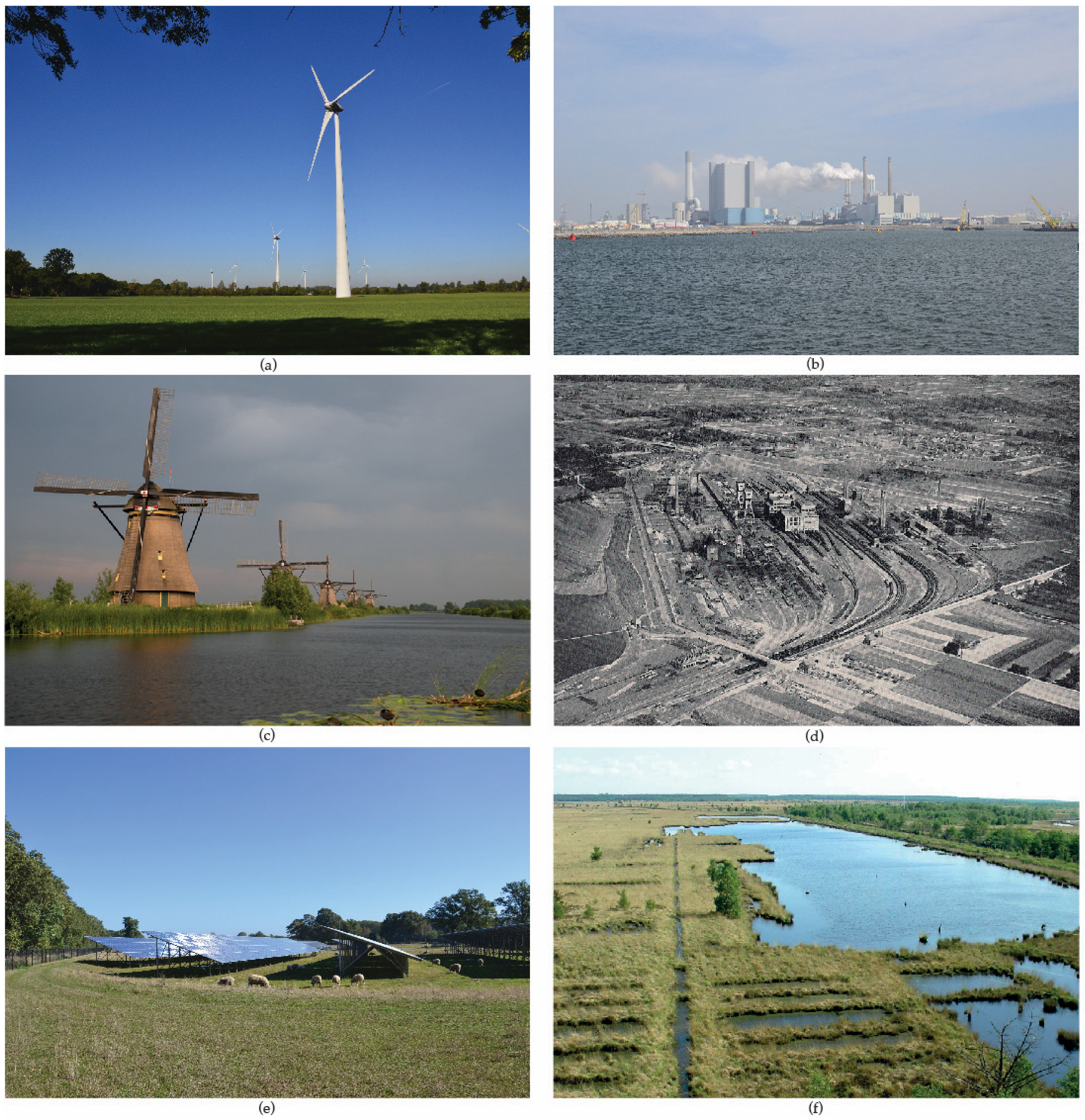
4.3. The Third Energy Period: Wind Energy

Around 1400, while ever more peat was extracted for energy purposes and land cultivated for agriculture, a new technology was introduced: the windmill (Figure 7). The majority of windmills in the Western Netherlands were used to drain water from the land; land that, otherwise, had no longer been suitable for agricultural use due to excessive peat extraction and/or land subsidence. The early ‘droogmakerijen’ and polders, mainly in the province of Zuid-Holland, were created employing windmills. The largest energy demand during the third period was that from industry; mainly mechanical energy supplied by windmills [72]. In some places, the introduction of windmills resulted in what was then considered an ‘industrial landscape,’ such as the Zaanstreek in the North of Amsterdam (see Figure 8).
Substantive qualification: Although peat remained the most important fuel during the third energy period, windmills contributed to the further transformation of the landscape. Besides the physical appearance of this energy technology itself, windmills were employed in the creation of polders; many of which still exist today. The first droogmakerijen with windmills were the Achtermeerpolder to the south of Alkmaar in 1533 [72] and the Egmondermeerpolder created in 1565 [76]. The oldest windmill in the case study area (included in Figure 8) is from the beginning of the 14th century and located near Voorschoten, to the south of Leiden [77]. By 1600, the majority of windmills had been built [72]; many are still visible in the landscape. The Province of Zuid-Holland, for example, still hosts 228 windmills—one quarter of all historical Dutch windmills [78]. This energy technology, nowadays, continues to present one of the most photogenic landscape elements and an iconic feature of The Netherlands as a nation.
Spatial qualification: Two spatial expressions of the third energy period can be found within the region and one outside. Windmills, to begin with, are visually prominent and constitute components in a landscape that hosts other functions and land uses. The ‘droogmakerijen,’ on the contrary, form clear entities in the landscape (see Figure 8). Due to the increasing shortage of peat in the Western Netherlands during the third energy period, peat was imported from other regions such as the northeastern part of the country, which gave rise to new energy landscapes over there [79]. In this period, the surface of ‘droogmakerijen’ in the case study area is circa 420 km2, equaling 10% of the total landmass. Today, the surface of ‘droogmakerijen’ in the Netherlands is circa 2500 km2 [73].
Temporal qualification: Windmills can be conceptualized as ‘additions’ to the existing landscape rather than ‘subtractions’ [6]. When windmills were demolished—and many were—the energy landscape changed once again and other landscape features gained visual prominence. That is why the temporal qualification of the wind energy landscape in the third energy period is considered dynamic, even though some of the windmills lasted for hundreds of years. The remaining windmills have become much valued and preserved elements of the cultural landscape. The ‘droogmakerijen’ are considered a permanent energy landscape and still present many cues of the third energy period in the Western Netherlands.

4.4. The Fourth Energy Period: Fossil Fuels

The introduction of steam machines to the Western Netherlands in the early 19th century marks the start of the fourth energy period, dominated by fossil fuels. Steam engines were introduced to produce more, faster and at lower costs [57]. Steam pumps were used for water management in the region [72]. The introduction of machines powered by fossil fuels (coal, petroleum, and natural gas) allowed for land reclamation at an unprecedented pace and spatial extent. Large lakes and abandoned polders were reclaimed throughout and beyond the Western Netherlands. During the fourth energy period, the area of the natural peat landscape shrunk from 66% of the total landmass to 36%. Peat remained the main energy source of the cities well into the 19th century—mostly imported from the northeast of the Netherlands [72].
Substantive qualification: During the fourth period, society relied predominantly on the accumulated stocks of mineral resources; high energy densities allowed to transport them over longer distances [6]. Initially, fossil fuels were used directly to power water pumps and, later on, to generate electricity for water management in the polders. From about 1900, after the introduction of power plants and power lines, electricity was generated from coal and oil and transmitted throughout the Western Netherlands and beyond [28].
Spatial qualification: The spatial expression of the new energy system was much different than those of earlier periods. Infrastructure for the transmission of electricity became the dominant component of the energy landscape in the fourth period. Electricity is transmitted throughout the landscape, above and below ground, by power lines [15]. In the second half of the 20th century, one distinguished a national system (about 380 kV), regional systems (150 kV), and local systems (50 kV or less) of power lines in The Netherlands. Transport and transmission networks not only affect the landscape of the Western Netherlands but also elsewhere in the country and abroad. Power plants and electricity infrastructure, together, present direct components of the energy landscape. Energy-intensive industries, car-mobility and the associated transport infrastructure shape the energy landscape indirectly [74]. Pasqualetti describes the energy landscape of the fourth period as ‘hub and spoke signature,’ referring to the power plants and their networks for fuel supply entering and electricity leaving the plants [6]. The extraction of fossil fuels did not leave a dominant imprint on the landscape in the Western Netherlands. This is because natural gas and oil were extracted on a relatively small scale; extraction sites are indicated in Figure 9. Somewhat similar to the import of peat energy in the third period, the import of fossil fuels and electricity shaped energy landscapes elsewhere in the country and abroad. While the spatial expression of fossil fuels extraction in the Western Netherlands is small-scale, the landscapes of transporting, storing, and refining imported fossil fuels are large-scale and often located in harbors such as in Rotterdam. In comparison to earlier energy periods, however, the spatial imprint of the fourth period is smaller in terms of surface [16]. Fossil-fuel harbors, power plants and droogmakerijen—now sustained by fossil fuels—form entity energy landscapes. The majority of energy infrastructure, on the contrary, represents components in the multifunctional landscapes of the fourth energy period.
Temporal qualification: The extraction of fossil fuels in the Western Netherlands has an intermediate degree of permanence. After the closure of extraction facilities, the landscape evolves. The energy landscape associated with the generation and transmission of electricity is considered relatively dynamic because power plants and power lines can be (and have been) removed entirely.

4.5. The Fifth Energy Period: Modern Renewables

At the end of the 20th century, The Netherlands started to transit to a low-carbon economy, causing a revival of renewable energy sources such as wind energy. Sustainable energy transition comprises two key strategies: reducing energy demand and increasing the share of renewable energy employing modern technologies. Both of which—the latter more than the first—are starting to transform the landscape in the region. Wind turbines and photovoltaic parks are constructed in the Western Netherlands, similar to the rest of the country. Urban expansions, business parks, and logistic centers increase land use pressure in the region; more than elsewhere in the country.
Substantive qualification: Renewable energy sources such as wind, solar, and biomass directly influence parts of the (Western) Netherlands and give rise to a number of distinct energy landscapes. The renewable energy sources vary from relatively low density (biomass) to intermediate density (wind and solar)—all of which require larger shares of land compared with fossil fuels that dominated the fourth energy period. The installed wind power (on land) in the Netherlands has risen sharply: from 50 MW in 1990 to 3.4 GW in 2018 [80,81]. At the end of 2018, the total amount of PV capacity in the country amounted to 4.4 GW—one third of the PV panels installed on land [82].
Spatial qualification: New landscape components—wind turbines, solar panels, and energy crops—are emerging during the fifth energy period along with an improved electricity network to transmit renewable electricity (see Figure 10) [16,74]. The Western Netherlands hosted 139 modern wind turbines in 2019. Wind turbines and electricity infrastructure present components of the multifunctional landscape. Large fields with solar panels and energy crops are, to this moment, monofunctional and belong to the category of entity energy landscape. Besides their physical presence, wind turbines have a visual effect that may affect the appreciation of the associated energy landscape [74,80]. Two components of the fifth energy period, namely, solar panels and energy crops, result in changing agricultural practices [74] and compete with other functions such as food production. Other components, for example biogas plants, can result in nuisances such as smell, noise and increase local traffic (trucks transporting feedstock to the plants). The so-called ‘compensation measures’ often include creating new biotopes which, in turn, increases land use pressure [6,83]. The discussion on the potential impact of renewable energy technologies on landscape quality, biodiversity, and food production has resulted in spatially explicit studies for energy transition in The Netherlands (e.g., [84]), while other publications are starting to feature design guidelines for renewable energy landscapes in order to minimize negative effects (e.g., [85]).
Temporal qualification: The energy landscapes of the modern renewables period are considered dynamic. Solar panels and wind turbines can be removed at the end of their life cycle—the energy landscape is reversible. The ‘temporality’ of the underground energy infrastructure, however, may vary from dynamic to permanent depending on (local) policies and legislation. The biomass energy landscape is the most dynamic type and may only last one growing season (in the case of corn).

5. Discussion and Conclusions

Scholars continue to argue for a better understanding of historical landscape transformations [12] and the evolution of energy landscapes in particular [6,7,8,24]. The research presented in this paper set out to map the evolution of energy landscapes in the Western Netherlands, while making use of recently proposed definitions, typologies, and qualifications for the ‘energy landscape’ phenomenon. In doing so, we respond to calls by energy geographers such as Hui et al. [85] for more case studies on energy landscapes. In the following, we will discuss the nature of our case study, collaboration, and research approach, followed by a set of conclusions with respect to the objective and the main research question of the study presented in this paper.
The great majority of the examined publications on historical energy developments are nonspatial; they focus on technological innovation and socioeconomic changes. Only seven of the 39 publications refer to ‘landscape,’ which could be due to the relative novelty of the ‘energy landscape’ concept. The case study reported in this paper is spatially explicit and mapped the evolution of energy landscapes over a period of more than 1000 years. This spatiotemporal analysis of historical energy landscapes in the Western Netherlands contributes to an increasing body of knowledge on the spatial characteristics of energy systems [56], and the better understanding of significant shifts from one primary source to another (idem). Our series of detailed georeferenced maps is a novel feature amongst the (so far limited) body of literature on historical case studies (see, e.g., [86,87,88]). While the location of many landscapes elements could be mapped accurately (e.g., windmills), the location of some land uses is only indicative (e.g., fodder draft animals) because they are not featured on historic maps. Our research focused on the material dimension of energy systems—the physical energy landscape—and is considered complementary to the work of others focusing on sociocultural aspects such as landscape identity (e.g., [89]) and public acceptance (e.g., [1]).
The close cooperation with experts in the field of cultural history was critical for the mapping and analysis of historical landscape transformations, as one must be cautious about the reliability of the virtual reconstruction of historical maps [90]. These experts helped to interpret the historical maps because “[...] a map is as much a cultural construct as a landscape is, [...]” [13] (p. 61) and, most importantly, to associate landscape features with functions. While the extraction of peat during the second energy period (circa 17% of the peat landscape), for example, could have been interpreted as landscape transformation for energy development, they stressed that the main purpose was the cultivation of land for new settlements and farms.
With respect to case study research, Flyvberg argues that “context-dependent knowledge is […] more valuable than the vain search for predictive theories” [39] (p. 224). Either way, case study research is relevant if “the case being studied is typical of cases of a certain type and therefore a single case can provide insight into the events and situations prevalent in a group from where the case has been drawn” [91] (p. 196). Our case study revealed detailed information on the evolution of energy landscapes in low-lying peat areas. Whereas findings may apply for similar landscapes in the larger Delta and beyond, landscapes in other climate and soil conditions developed differently. However, our research does contribute to a larger number of thoroughly executed case studies, which—according to Flyvbjerg—is essential for an effective scientific discipline [39]. Within the field of energy geography, the value of case study research has been stressed repeatedly (see, e.g., [86,90]).
The conceptual framework, definitions and typologies proposed in this paper can be of value to other researchers examining the evolution of energy landscapes. The case study—to the best knowledge of the authors—presents the first all-encompassing application of the analytical framework for the study of energy landscapes by Pasqualetti and Stremke [25]. The three main qualifications—substantive, spatial, and temporal—provided a clear framework for the systematic study of landscape transformations at the regional scale. The notion of ‘trace,’ only briefly mentioned by Pasqualetti and Stremke [25], has been operationalized as ‘remnant’ in our case study and helped to describe the dynamic and multifaceted landscape transformations through time. Similar to Bridge et al. [56], we have employed additional descriptors—in our case, the four main components of energy systems proposed by Smil [55]—to illustrate developments in space and time.
The case study research reported in this paper aimed to map the evolution of energy landscapes in a region where changes have been recorded in writing and drawings. Accordingly, the research question was: What energy landscapes have evolved in the Western Netherlands and how can they be characterized with regard to energy source, spatial appearance and temporality?
The research shows that all energy transitions—new energy sources and associated energy infrastructure—resulted in the transformation of landscapes in the Western Netherlands. Five periods can be distinguished according to the most prominent energy sources: a first period of wood energy, a second period of peat energy, a third period of wind energy, a fourth period of fossil fuels, and a fifth period of modern renewables. Each of these energy periods resulted in distinct energy landscapes with particular substantive, spatial, and temporal characteristics.
Land reclamation and peat extraction, next to urbanization, have been identified as the main drivers of landscape transformation in the Western Netherlands. After the peat had been extracted—about three-quarters of the natural peat landscape disappeared—technologies such as windmills and coal-powered water pumps were deployed to continue cultivation and to manage water. The paper illustrates that the landscape of the Western Netherlands has been transformed for hundreds of years to provide, transport, and store different kinds of energy for human development.
From this historical perspective, the ongoing transition to modern renewables can be understood as yet another stage in the (more or less) continuous landscape evolution that mirrors human needs and societal values. The energy landscapes that developed in the Western Netherlands never completely replaced their predecessors, let alone at once. The energy landscape of each period, in other words, features remnants of previous energy periods.
Some energy landscapes have turned into much-appreciated cultural landscapes; for example, the UNESCO world heritage Kinderdijk near Rotterdam. The construction of windmills such as in Kinderdijk were, however, criticized by many at the time and the church, according to Alain de Botton, played a prominent role concerting resistance [92]. The British philosopher reminds us that resistance against certain spatial features of energy transition is not a contemporary phenomenon.
To conclude, the human development of energy has and will continue to give rise to new energy landscapes. While energy sources and technologies may change rapidly (relatively speaking), some of the associated landscape transformations are permanent and may affect future developments. In a way, the spatial expression of ‘energy’ in our living environment becomes richer time and again—the increasing complexity of energy landscapes provides us with important cues for the consequences of energy development, both in the past and the present.
While the objective of this research has been achieved—past landscape transformations recalled and mapped—one must admit that the relevance of such knowledge for the present-day discourse on energy transition lies in the fundamental realm rather than in the operational sphere. Decision tools, for example, cannot be developed on the mere basis of historical analysis even if the nature of such study is spatial. Instead, the growing understanding of historical landscape transformations has to conflate with the increasing body of knowledge on the effects of contemporary energy technologies to devise alternative low-carbon futures. We stress this point because we have learned that historical energy development shaped the landscapes we live in today and signs responsible for some of the spatial qualities we cherish so much (e.g., the open views in the ‘Green Heart’ national landscape [75]). This insight and the underlying facts provide new impetus for energy geography at large and the discourse on emotional energy geography in particular, both in understanding the past (see, e.g., [93]) and envisioning low-carbon futures (see, e.g., [94]).

Supplementary Materials

The following are available online at https://www.mdpi.com/2071-1050/12/11/4554/s1. File S1: List of interviewees and interview questions, File S2: List of maps analyzed during the case study.

Author Contributions

Both authors have conducted the conceptualization, methodology, investigation, writing, and editing of this article jointly. All authors have read and agreed to the published version of the manuscript.

Funding

This research was supported by the Rijksdienst voor Cultureel Erfgoed (RCE).

Acknowledgments

The authors wish to thank Henk Baas and Berthe Jongejan (both RCE), Adri van den Brink and Marlies Brinkhuijsen (both Wageningen University) for the internal review. We also like to acknowledge the contribution of the 15 interviewees (names listed in supplementary material File S1). The project illustrates RCE’s commitment to support academic research and is linked with both the cultural heritage in landscape (CHeriScape) and the renewable energy and landscape quality network (RELY/EU COST action).

Conflicts of Interest

The authors declare no conflict of interest.

Appendix A

Table A1. Results of the literature review, organized according to energy sources.
Energy Sources in LiteratureStudied PublicationsEnergy Landscape if Explicitly Named
BooksPeer-Reviewed ArticlesGrey Literature
[84][95][96][11][57][3][18][19][97][98][99][100][49][15][6][58][5][2][4][27][101][16][14][102][20][22][21][25][103][104][105][106][107][108][109][110][28][111][112][113]
Muscle powerDraft animals X X X XX XXX X
Human labour X X X XX X XXX X
Biomass energyWoodFirewood XX X XXXXXXX XXXXXXX X X Y X XX XXBiomass landscape [25]
Charcoal X X X
PeatHoogveen * X XX X XX X X X Y XX XPeat energy landscape [25]
Laagveen # X X X XX X X X X
Energy crops XX YX XXX X X XXX XXXX XX X Bioenergy landscape [3]
WasteSolid X X X X X X X XX X X
Liquid X XX X X X X
Gaseous X X X XX X
Alcohol fuels X X X X XX X
Wind energyWind mills X X XX XX X XX X Y XX X XWind energy landscape [25]
Wind turbinesXXX YXXXXXXX XX X XX Y YX XX XX X Wind power landscape [3,20]; Wind energy landscape [25]
Water energyWater mills X X X X X X X X X
Hydropower X XXYXX XX X XX X XXY YY XX X Hydropower landscape [3,21,25,102]
Blue energy X XXX XX XX
Solar energyDirect heatX X X XXX X XX X XXX Y X X Solar energy landscape [25]
PhotovoltaicsXXX YXXX XXX XX X XXX YXXX XX X Solar power landscape [3]; Solar energy landscape [25]
Heat cold storage X X X X X
Thermal energyDeep geothermal heatX XXXX X XX X XXX Y XX X Geothermal energy landscape [25]
Fossil fuels Conventional fossilsCoal X X XX X XXXXX XXXX X XX X XX X Coal energy landscape [25]
Naturalgas X X XXX XX XXXX XX X YXXX Y XXX Natural gas production landscape [109]; Natural gas energy landscape [25]
Shalegas X
Oil i.e., petroleum XXX XX X YX XX XX XX X Y X XXX Petroleum landscape [100]; Oil energy landscape [25]
Whaleoil X
Unconv. fossilsTarsands Y Unconventional fossil fuel landscape [25]
Coal-bedmethane Y Unconventional fossil fuel landscape [25]
Nuclear energy X XX XXXX XXXX XX Y XX X X Nuclear energy landscape [25]
Various energy sourcesElectricity generation X X XX XX X X XX X X
Transport/transmission XX X X X X X X X
Total number of subtypes mentioned per publication491241041712141611122021613518846141613112135913112114143117
Total number of main energy sources mentioned3444548768789185486337761127577111168264
X marks which energy source is mentioned by which author(s). Y marks the energy sources that are associated with ‘energy landscape’ in the respective publication. Names of energy landscapes mentioned in the literature are shown in the right column. * Hoogveen = higher fen, referring to the areas where peat developed above water level such as in the northeast of the Netherlands. # Laagveen = lower fen, referring to the areas where peat developed below the water level such as in the Western Netherlands.

References

  1. Roddis, P.; Carver, S.; Dallimer, M.; Ziv, G. Accounting for taste? Analysing diverging public support for energy sources in great britain. Energy Res. Soc. Sci. 2019, 56, 101226. [Google Scholar] [CrossRef]
  2. Sijmons, D.; Hugtenburg, J.; van Hoorn, A.; Feddes, F. Landscape and Energy—Designing Transition; NAI Uitgevers: Rotterdam, The Nederlands, 2014. [Google Scholar]
  3. Frolova, M.; Prados, M.J.; Nadai, A. (Eds.) Renewable Energies and European Landscapes—Lessons from Southern European Cases; Springer: Dordrecht, The Netherlands, 2015. [Google Scholar]
  4. Smil, V. Energy in World History; Westview Press: Boulder, CO, USA, 1994. [Google Scholar]
  5. Sieferle, R.P. The Subterranean Forest—Energy Systems and the Industrial Revolution; Cambridge—The White Horse Press: Cambridgeshire, UK, 2001. [Google Scholar]
  6. Pasqualetti, M.J. Reading the changing energy landscape. In Sustainable Energy Landscapes—Designing, Planning and Development; Stremke, S., van den Dobbelsteen, A., Eds.; CRC Press: Boca Raton, FL, USA, 2013. [Google Scholar]
  7. van der Horst, D. Energy landscapes of less than two-degree global warming. In Handbook on the Geographies of Energy; Solomon, B., Calvert, K., Eds.; Edward Elgar Publishing: Northampton, UK, 2017. [Google Scholar]
  8. Solomon, B.; Calvert, K. Introduction: Energy and the geographical traditions. In Handbook on the Geographies of Energy; Solomon, B., Calvert, K., Eds.; Edward Elgar Publishing: Northampton, UK, 2017. [Google Scholar]
  9. Geels, F.; Berkhout, F.; van Vuuren, D. Bridging analytical approaches for low-carbon transitions. Nat. Clim. Chang. 2016, 6, 576–583. [Google Scholar] [CrossRef] [Green Version]
  10. Intergovermental Panel on Climate Change (IPCC). Special Report on Renewable Energy Sources and Climate Change Mitigation; Cambrige University Press: Cambridge, UK; New York, NY, USA, 2011. [Google Scholar]
  11. Crowe, S. The Landscape of Power; The Architectural Press: London, UK, 1958. [Google Scholar]
  12. Antrop, M. Why landscapes of the past are important for the future. Landsc. Urban Plann. 2005, 70, 21–34. [Google Scholar] [CrossRef]
  13. Kuitert, W. Urban landscape systems understood by geo-history map overlay. J. Landsc. Architec. 2013, 8, 54–63. [Google Scholar] [CrossRef]
  14. Verbong, G.; van Selm, A.; Knoppers, R.; Raven, R. Een Kwestie van Lange Adem—De Geschiedenis van Duurzame Energie in Nederland; Aeneas: Boxtel, The Netherlands, 2001. [Google Scholar]
  15. Noorman, K.; de Roo, G. (Eds.) Energielandschappen—de 3de Generatie [Energy Landscapes, the 3rd Generation]; Provincie Drenthe: Assen, The Netherlands, 2011. [Google Scholar]
  16. van Kann, F.M.G. Energie en Ruimtelijke Planning—Een Spannende Combinatie. Ph.D. Thesis, University of Groningen, Groningen, The Netherlands, 2015. [Google Scholar]
  17. Blaschke, T.; Biberacher, M.; Gadocha, S.; Schardinger, I. Energy landscapes—Meeting energy demands and human aspirations. Biom. Bioenerg. 2013, 55, 3–16. [Google Scholar] [CrossRef] [Green Version]
  18. Gordijn, H.; Verwest, F.; van Hoorn, A. Energie is Ruimte; Ruimtelijk Planbureau: Den Haag, The Netherlands, 2003. [Google Scholar]
  19. Goshn, R. (Ed.) Landscapes of Energy; Harvard University Press: Cambridge, MA, USA, 2019. [Google Scholar]
  20. Lambussiere, O.; Nadai, A. Unexpected wind power potentials. The art of planning with inherited socio-geographical configurations (France). Scottish Geograp. J. 2014, 130, 152–167. [Google Scholar] [CrossRef] [Green Version]
  21. Nadai, A.; van der Horst, D. Introduction—Landscape of energies. Landsc. Res. 2010, 35, 143–155. [Google Scholar] [CrossRef] [Green Version]
  22. Maxwell, K. Beyond verticality—Fuelscape politics and practices in the Andes. Human Ecol. 2011, 39, 465–478. [Google Scholar] [CrossRef]
  23. Stremke, S. Sustainable Energy Landscape: Implementing energy transition in the physical realm. Encycl. Environ. Manag. 2015. [Google Scholar] [CrossRef]
  24. Selman, P. Learning to love the landscapes of carbon-neutrality. Landsc. Res. 2010, 35, 157–171. [Google Scholar] [CrossRef]
  25. Pasqualetti, M.J.; Stremke, S. Energy landscapes in a crowded world: A first typology of origins and expressions. Energ. Res. Soc. Sci. 2018, 36, 94–105. [Google Scholar] [CrossRef]
  26. Rotmans, J.; Kemp, R.; van Asselt, M. More evolution than revolution: Transition management in public policy. Foresight 2001, 3, 15–31. [Google Scholar] [CrossRef]
  27. Smil, V. Power Density—A Key to Understanding Energy Sources and Uses; The MIT Press: Cambridge, MA, USA, 2015. [Google Scholar]
  28. Rijksdienst voor Cultureel Erfgoed (RCE). Handreiking Energie, Erfgoed en Ruimte; RCE: Amersfoort, The Netherlands, 2016. [Google Scholar]
  29. Directie Kennis en Innovatie Ontgonnen Verleden: Hoofdstuk 18 Landschap 6: Laagveengebied. Available online: http://edepot.wur.nl/146359 (accessed on 20 July 2017).
  30. Devine-Wright, P. Explaining ‘NIMBY’ objections to a power line—The role of personal, place attachment and project-related factors. Environ. Behav. 2012, 45, 761–781. [Google Scholar] [CrossRef]
  31. Leenaers, H.; Camarasa, M. De Bosatlas van de Energie; Noordhoff Uitgevers: Groningen, The Netherlands, 2012. [Google Scholar]
  32. Frolova, M.; Centeri, C.; Benediktsson, K.; Hunziker, M.; Kabai, R.; Scognamiglio, A.; Martinopoulos, G.; Sismani, G.; Brito, P.; Cerón, E.M.; et al. Effects of renewable energy on landscape in Europe: Comparison of hydro, wind, solar, bio-, geothermal and infrastructure energy landscapes. Hung. Geogr. Bull. 2019, 68, 317–339. [Google Scholar] [CrossRef]
  33. Calvert, K.; Greer, K.; Maddison-MacFadyen, M. Theorizing energy landscapes for energy transition management: Insights from a socioecological history of energy transitions in Bermuda. Geoforum 2019, 102, 191–201. [Google Scholar] [CrossRef]
  34. ‘Kinderdijk Before a Storm’. Uploaded by Roman Boed, 16 July 2015. Licensed under a Creative Commons 2.0 License. The Original Photo is Slightly Cropped. Available online: https://www.flickr.com/photos/romanboed/19916318502 (accessed on 21 July 2017).
  35. ‘Staatsmijn MauritsxLutterade’. Uploaded by PK, 3 November 2013. Licensed under a Creative Commons 2.0 License. The Original Photo is Slightly Cropped. Available online: https://www.flickr.com/photos/uair01/10646574825 (accessed on 21 July 2017).
  36. Het Fochteloërveen—Hoogveengebied op de Grens van Groningen en Friesland’. Author: Gouwenaar, 21 May 2008. Licensed under Wikimedia Commons, Public Domain. Available online: https://nl.wikipedia.org/wiki/Bestand:Fochtloerveen.jpg (accessed on 21 July 2017).
  37. Creswell, J.W. Research Design—Qualitative, Quantitative, and Mixed Methods Approaches; SAGE: Thousand Oaks, CA, USA, 2014. [Google Scholar]
  38. Yin, R.K. Case Study Research—Design and Methods; SAGE: Thousand Oaks, CA, USA, 2014. [Google Scholar]
  39. Flyvbjerg, B. Five Misunderstandings about Case-Study Research. Qual. Inq. 2006, 12, 219–245. [Google Scholar] [CrossRef] [Green Version]
  40. Johnson, K.E.; Stake, R.E. The Art of Case Study Research. Mod. Lang. J. 1996, 80, 556. [Google Scholar] [CrossRef]
  41. Yin, R.K. Applications of Case Study Research; SAGE: Thousand Oaks, CA, USA, 2012. [Google Scholar]
  42. Deming, M.E.; Swaffield, S. Landscape Research; Inquiry, Strategy Design Wiley: Hoboken, NJ, USA, 2011. [Google Scholar]
  43. Picuno, P.; Cillis, G.; Statuto, D. Investigating the time evolution of a rural landscape: How historical maps may provide environmental information when processed using a GIS. Ecol. Eng. 2019, 139, 105580. [Google Scholar] [CrossRef]
  44. Hesse-Biber, S.; Leavy, P. Distinguishing qualitative research. In Approaches to Qualitative Research—A Reader on Theory and Practice; Hesse-Biber, S.N., Leavy, P., Eds.; Oxford University Press: New York, NY, USA, 2004. [Google Scholar]
  45. Tan, F.B.; Hunter, M.G. The Repertory Grid Technique: A Method for the Study of Cognition in Information Systems. MIS Q. 2002, 26, 39. [Google Scholar] [CrossRef]
  46. Vos, P.; de Vries, S. 2e Generatie Palaeogeografische Kaarten van Nederland. Del-tares, Utrecht. Available online: https://www.noviomagus.info/ontoegankelijk.htm (accessed on 25 July 2017).
  47. Borger, G.; Horsten, H.F.; Engel, R.; Rutte, O.; Diesfeldt, I.; Pané, A. Twaalf eeuwen ruimtelijke transformatie in het westen van Nederland in zes kaartbeelden: Landschap, bewoning en infrastructuur in 800, 1200, 1500, 1700, 1900 en 2000. In OverHolland; Sun Publisher: Amsterdam, The Netherlands, 2011; pp. 4–124. [Google Scholar]
  48. RCE. Droogmakerijen met molens en gemalen. GIS-File Unpublished work. 2017. [Google Scholar]
  49. Cranfield, I.; Ormeling, F.J.; Schulze, H.; Fullard, H.; Darby, H.C. De Grote Bosatlas. Geogr. J. 1978, 144, 371. [Google Scholar] [CrossRef]
  50. van den Kerkhoff, J. Urban Use of Peat Soils. Peat Lands Lying below Sea Level in the Western Part of the Netherlands, Their Geology, Reclamation, Soils, Management, and Land Use. Available online: http://edepot.wur.nl/74512 (accessed on 20 July 2017).
  51. ‘Winterlandschap’. Paul Bril after Aegidius Sadeler. Licensed under a Creative Commons Public Domain Mark 1.0 License. Available online: https://www.europeana.eu/portal/nl/record/90402/SK_A_2672.html (accessed on 14 July 2019).
  52. ‘Peat Dragging in Holland, ca. 1800’. Author Unknown. Available online: https://nl.wikipedia.org/wiki/Bestand:Veenderij_Turfwinning.jpg (accessed on 21 July 2017).
  53. ‘Nieuwkoopse Plassen’. Photo by Jan Arkesteijn. Licensed under Wikimedia Commons, Public Domain. Available online: https://commons.wikimedia.org/wiki/File:Nieuwkoopse_Plassen_20070721.jpg (accessed on 21 July 2017).
  54. ‘Haarlemmermeerpolder’. Photo by Ilonamay, February 3, 2017. Licensed Under a Creative Commons License ShareAlike 3.0 Unported License. Available online: https://nl.wikipedia.org/wiki/Bestand:Haarlemmermeerpolder.jpg (accessed on 21 July 2017).
  55. Smil, V. Energy in Nature and Society: General Energetics of Complex Systems; MIT Press: Cambridge, MA, USA, 2008. [Google Scholar]
  56. Bridge, G.; Bouzarovski, S.; Bradshaw, M.; Eyre, N. Geographies of energy transition: Space, place, and the low-carbon economy. Energy Policy 2013, 53, 331–340. [Google Scholar] [CrossRef]
  57. Debeir, J.C.; Deléage, J.P.; Hémery, D. In the Servitude of Power—Energy and Civilization through the Ages; Zed Books: London, UK, 1991. [Google Scholar]
  58. Pimentel, D.; Pimentel, M.H. Food, Energy and Society; CRC Press: Boca Raton, FL, USA, 2008. [Google Scholar]
  59. Hausrath, H. Der Deutsche Wald: Aus Natur und Geisteswelt; Teubner: Leipzig, Germany, 1907. [Google Scholar]
  60. Mitscherlich, G. Zustand, Wachstum und Nutzung des Waldes im Wandel der Zeit; Hans Ferdinand Schulz: Freiburg, Germany, 1963. [Google Scholar]
  61. van Dam, P.J.E.M. Vissen in Veenmeren De sluisvisserij op aal tussen Haarlem en Amsterdam en de Ecologische Transformatie van Rijnland 1440–1530; Uitgeverij Verloren: Hilversum, The Netherlands, 1998. [Google Scholar]
  62. Bostock, J.; Riley, H.T. The Natural History of Pliny (Translation into English); Bohn: London, UK, 1885. [Google Scholar]
  63. Cultureelerfgoed.nl. Landschap 6–Laagveengebied. Available online: https://studylibnl.com/doc/982735/18-landschap-6--laagveengebied---rijksdienst-voor-het-cul (accessed on 18 July 2017).
  64. Cornelisse, C.H. The Economy of Peat and its Environmental Consequences in Holland during the Late Middle Ages. In Jaarboek voor Ecologische Geschiedenis 2005–2006; Academia Press: Gent, Belgium, 2006; pp. 95–122. [Google Scholar]
  65. Unger, R.W. Energy Sources for the Dutch Golden Age—Peat, Wind, and Coal. Res. Econ. Hist. 1984, 9, 221–253. [Google Scholar]
  66. Jongepier, I.; Soens, T.; Thoen, E.; Eetvelde, V.; Crombé, P.; Bats, M. The brown gold: A reappraisal of medieval peat marshes in Northern Flanders (Belgium). Water Hist. 2011, 3, 73–93. [Google Scholar] [CrossRef] [Green Version]
  67. Geologievannederland.nl. Veenbodem. Available online: http://www.geologievannederland.nl/ondergrond/bodems/veenbodem-veenlandschap (accessed on 20 July 2017).
  68. Karel, E. Colonizing peatlands. Transformation or deformation of peat areas in the Netherlands 1000–2000. In Proceedings of the Circulating Natures: Water-Food-Energy of the European Society for Environmental History (ESEH), Munich, Germany, 20–24 August 2013. [Google Scholar]
  69. Nassi, O.; di Nasso, N.; Guidi, W.; Ragaglini, G.; Tozzini, C.; Bonari, E. Biomass production and energy balance of a 12-year-old short-rotation coppice poplar stand under different cutting cycles. Glob. Chang. Biol. Bioenergy 2010, 2, 89–97. [Google Scholar] [CrossRef]
  70. Chmielniak, T.; Ściążko, M. Co-gasification of biomass and coal for methanol synthesis. Appl. Energy 2003, 74, 393–403. [Google Scholar] [CrossRef]
  71. Low-Tech Magazine. What is the Energy Density of Peat or Turf? Available online: http://www.lowtechmagazine.com/whats-the-energy-density-of-peat-or-turf-.html (accessed on 25 July 2017).
  72. Kosian, M. Droogmakerijen. Rijksdienst voor Cultureel Erfgoed. Available online: https://landschapinnederland.nl/sites/default/files/map_attachments/104263_Droogmakerijen_PDFA.pdf (accessed on 20 July 2017).
  73. Alterra. Neder-Landschap Internationaal; Bouwstenen voor een Selectie van Gebieden voor Landschapsbehoud [Dutch-Landscape International: Building Blocks for a Selection of Areas for Landscape Preservation]; Alterra: Wageningen, The Netherlands, 2011. [Google Scholar]
  74. Baart, T. Energielandschappen een Fotografische Nulmeting; College van Rijksadviseurs, CRA: Den Hague, The Netherlands, 2014. [Google Scholar]
  75. CLO (Compendium voor de Leefomgeving). Nationaal Landschap Groene Hart. Available online: https://www.clo.nl/indicatoren/nl1489-groene-hart (accessed on 23 November 2016).
  76. Polders! Gedicht Nederland; Geuze, A.; Feddes, F. (Eds.) NAi Uitgevers: Rotterdam, The Netherlands, 2005. [Google Scholar]
  77. Erfgoedhuis Zuid-Holland. Geschiedenis van Zuid-Holland. De Eerste Molens en Het Gebruik Van Wind. Available online: https://geschiedenisvanzuidholland.nl/verhalen/de-eerste-molens-en-het-gebruik-van-wind (accessed on 20 July 2017).
  78. Provincie Zuid-Holland. Beleidsvisie Cultureel Erfgoed en Basisvoorzieningen Cultuur. Available online: https://www.zuid-holland.nl/publish/pages/16697/beleidsvisiecultureelerfgoed2017-2020.pdf (accessed on 20 July 2017).
  79. van Deukeren, H. Jaarboek Oud-Utrecht; Oud-Utrecht: Utrecht, The Netherlands, 1991; pp. 143–172, ISSN 0923-7046. [Google Scholar]
  80. CLO (Compendium voor de Leefomgeving). Windturbines op Land en op Zee 1990–2016. Available online: https://www.clo.nl/indicatoren/nl1475-windturbines-in-de-groene-ruimte (accessed on 7 August 2018).
  81. RVO. Monitor Wind op Land 2018, 6th ed.; Rijksdienst voor Ondernemend Nederland: Den Haag, The Netherlands, 2019. [Google Scholar]
  82. van Rijn, B. Beleidskaders zon-pv. Inventarisatie en Analyse. i.o.v. Min. EZK; Klimaatbeleid: Een Handelingsperspectief voor Gemeenten; Faculteit der Managementwetenschappen: Nijmegen, The Netherlands, 2019. [Google Scholar]
  83. Sijmons, D.; Frijters, E.; Wijnakker, R.; Hugtenburg, J.; Stremke, S.; Hocks, B.; Vermeulen, M.; Gerretsen, P. Energie & Ruimte [Energy & Space]; Deltametropool: Den Hague, The Netherlands, 2019. [Google Scholar]
  84. Apostol, D.; Palmer, J.; Pasqualetti, M.; Smardon, R.; Sullivan, R. The Renewable Energy Landscape: Preserving Scenic Values in our Sustainable Future. Routledge: New York, NY, USA, 2016. [Google Scholar]
  85. Hui, A.; Day, R.; Walker, G.P. Identifying Research Strategies and Methodological Priorities for the Study of Demanding Energy. In Demanding Energy; Springer Science and Business Media LLC: New York, NY, USA, 2017; pp. 341–354. [Google Scholar]
  86. Harrison, C. The historical–geographical construction of power: Electricity in Eastern North Carolina. Local Environ. 2013, 18, 469–486. [Google Scholar] [CrossRef]
  87. Murray, S. The energyscape of the lower Thames and Medway: Britain’s changing patterns of energy use. Landsc. Hist. 2020, 41, 99–120. [Google Scholar] [CrossRef]
  88. San-Antonio-Gómez, C.; Velilla, C.; Manzano-Agugliaro, F. Urban and landscape changes through historical maps: The Real Sitio of Aranjuez (1775–2005), a case study. Comput. Environ. Urban Syst. 2014, 44, 47–58. [Google Scholar] [CrossRef]
  89. Lewellyn, D.H.; Rohse, M.; Bere, J.; Lewis, K.; Fyfe, H. Transforming landscapes and identities in the south Wales valleys. Landsc. Res. 2017, 44, 804–821. [Google Scholar] [CrossRef] [Green Version]
  90. Sovacool, B.K. What are we doing here? Analyzing fifteen years of energy scholarship and proposing a social science research agenda. Energy Res. Soc. Sci. 2014, 1, 1–29. [Google Scholar] [CrossRef]
  91. Kumar, R. Research Methodology—A Step-by-Step guide for Beginners; SAGE: Thousand Oaks, CA, USA, 2014. [Google Scholar]
  92. de Botton, A. The Pleasures and Sorrows of Work; Penguin books: London, UK, 2009. [Google Scholar]
  93. Rohse, M.; Day, R.; Llewellyn, D. Towards an emotional energy geography: Attending to emotions and affects in a former coal mining community in South Wales, UK. Geoforum 2020, 110, 136–146. [Google Scholar] [CrossRef]
  94. Sijmons, D.; van Dorst, M. Strong feelings: Emotional landscape of wind turbines. In Sustainable Energy Landscapes: Designing, Planning, and Development; Stremke, S., van den Dobbelsteen, A., Eds.; CRC Press: Boca Raton, FL, USA, 2012. [Google Scholar]
  95. Bade, E. Energielandschappen—Een Fotografische Nulmeting [Energy Landscapes–A Photographic Survey]; Office of the Dutch State Adviser for Landscape: Den Hague, The Netherlands, 2014. [Google Scholar]
  96. Bade, B.; Lardinois, R. Het Energielandschap [The Energy Landscape]; KNNU Uitgeverij: Zeist, The Netherlands, 2010. [Google Scholar]
  97. Ter-Haar, I.; Stijkel, A.; Westendorp, P.; Zomer, S. P-NUTS Lokale Duurzame Energie in Nederland [P-NUTS Local sustainable energy in The Netherlands]; NEWNRG: Amsterdam, The Netherlands, 2011. [Google Scholar]
  98. Kander, A.; Malanima, P.; Warde, P. Power to the People—Energy in Europe Over the Last Five Centuries; Princeton University Press: Princeton, NJ, USA, 2013. [Google Scholar]
  99. Mackay, D. Sustainable Energy—without the Hot Air; UIT Cambridge: Cambridge, UK, 2009. [Google Scholar]
  100. Margalit, H. Energy, Cities and Sustainability—An Historical Approach; Routledge: London, UK, 2016. [Google Scholar]
  101. Stremke, S. Designing Sustainable Energy Landscapes: Concepts, Principles and Procedures. Ph.D. Thesis, Wageningen University, Wageningen, The Netherlands, 2010. [Google Scholar]
  102. Howard, D.; Burgess, P.; Butler, S.; Carver, S.; Cockerill, T.; Coleby, A.; Gan, G.; Goodier, C.; van Der Horst, D.; Hubacek, K.; et al. Energyscapes: Linking the energy system and ecosystem services in real landscapes. Biomass Bioenergy 2013, 55, 17–26. [Google Scholar] [CrossRef] [Green Version]
  103. Soini, K.; Pouta, E.; Salmiovirta, M.; Uusitalo, M.; Kivinen, T. Residents’ perceptions of energy landscape: The case of transmission lines. Land Use Policy 2011, 28, 294–305. [Google Scholar] [CrossRef]
  104. Knoot, R.; de Waal, R. Brown Coal Mining and Rehabilitation: A Landscape Chronicle. Master’s. Thesis, Wageningen University, Wageningen, The Netherlands, 2009. [Google Scholar]
  105. DGGL. Energielandschaften Geschichte und Zukunft der Landnutzung [Energy landscapes—History and Future of Land Use]; Callwey: Minhen, Germany, 2013. [Google Scholar]
  106. Feddes, Y. Windmolens hebben een Landschappelijk Verhaal Nodig [Wind Turbines Require a Landscape Narrative]; Office of the Dutch State Adviser for Landscape: Den Hague, The Netherlands, 2009. [Google Scholar]
  107. Feddes, Y. Een Choreografie Voor 1000 Molens [A choreography for 1000 wind turbines]; Office of the Dutch State Adviser for Landscape: Den Hague, The Netherlands, 2011. [Google Scholar]
  108. Oudes, D. Designing landscapes with high-voltage substations. Master’s Thesis, Wageningen University, Wageningen, The Netherlands, 2012. [Google Scholar]
  109. Peters, V. Recycling Energy Landscape: The Natural Gas Production Landscape of Groningen. Master’s Thesis, Wageningen University, Wageningen, The Netherlands, 2016. [Google Scholar]
  110. RCE (Rijksdienst voor Cultureel Erfgoed). Verkenning Energielandschappen en Erfgoed [Exploration of Energy Landscape and Heritage]; RCE: Amersfoort, The Netherlands, 2012. [Google Scholar]
  111. Snippert, T. Hidden Power: Veenkolonien 3.0. Master’s Thesis, Wageningen University, Wageningen, The Netherlands, 2012. [Google Scholar]
  112. Snippert, T. Hidden Power Nederland; College van Rijksadviseurs: Den Hague, The Netherlands, 2017. [Google Scholar]
  113. Straaten, T. Sustainable Energy Landscapes: Past, Present & Future. Master’s Thesis, Wageningen University, Wageningen, The Netherlands, 2012. [Google Scholar]
Figure 1. Dutch energy landscapes: (a) wind energy landscape in Aalten (Own photograph by Sven Stremke); (b) fossil fuel energy landscape of Rotterdam harbor (Own photograph by Sven Stremke); (c) historical wind energy landscape near Kinderdijk [34]; (d) coal energy landscape near Lutterade [35]; (e) solar energy landscape near Groenlo (Own photograph by Sven Stremke); (f) peat landscape Fochteloërveen [36].
Sustainability 12 04554 g001
Figure 2. Location of the Western Netherlands case study (dashed line)—encompassing parts of the provinces Noord-Holland, Zuid-Holland, and Utrecht—and several cities/places mentioned in the paper.
Sustainability 12 04554 g002
Figure 3. Deforestation (a) [51] and peat extraction (b) [52] caused major landscape transformations visible, for example, near Nieuwkoop in Zuid-Holland (c) [53]. Later, some of the land was drained for agricultural purposes, such as in the Haarlemmermeer in Noord-Holland (d) [54].
Sustainability 12 04554 g003
Figure 4. Map of the energy landscape in the Western Netherlands during the first energy period.
Sustainability 12 04554 g004
Figure 5. Map of the energy landscape in the Western Netherlands during the second energy period.
Sustainability 12 04554 g005
Figure 6. Peat extraction near Amstelveen in the Western Netherlands, by Jan Casper Philips (Rijksmuseum, Amsterdam).
Sustainability 12 04554 g006
Figure 7. Wind energy landscape in lower fen area (Jan Hendrik Weissenbruch, Polderlandschap, ca. 1844–1903, oil paint on panel, 24.5 × 36.5 cm, Groninger Museum, on loan from J.B. Scholtenfonds, photo: Marten de Leeuw).
Sustainability 12 04554 g007
Figure 8. Map of the energy landscape in the Western Netherlands during the third energy period.
Sustainability 12 04554 g008
Figure 9. Map of the energy landscape in the Western Netherlands during the fourth energy period.
Sustainability 12 04554 g009
Figure 10. Map of the energy landscape in the Western Netherlands at the start of the fifth energy period.
Sustainability 12 04554 g010
Table 1. Overview of the historical periods in the Netherlands and different sets of energy periods.
General Periods in Dutch HistoryPeriod 1:
Early Middle Ages
(Until 1000)
Period 2:
Middle Ages
(1000–1500)
Period 3:
Pre-Industrial Early Modern Time
(1500–1800)
Period 4:
Modern Time/
Industrialization
(1800–2000)
Period 5:
Post-Industrial Time (Present-Day)
Four types of energy economies [6]Organic economyMineral economyElectricity economySustainable economy
Three generations of energy landscapes [15]1st-generation energy landscapes2nd-generation energy landscapes3rd-generation energy landscapes
Energy periods defined in case studyPeriod of wood energyPeriod of peat energyPeriod of wind energyPeriod of fossil fuelsPeriod of modern renewables
Table 2. Overview of the five energy periods and the associated components of the energy system in the Western Netherlands.
Energy Periods1. Period of Wood Energy (<1000)2. Period of Peat Energy (1000–1500)3. Period of Wind Energy (1500–1800)4. Period of Fossil Fuels (1800–2000)5. Period of Modern Renewables
Spatial components of the energy system: Dominant components shown in bold; lines in-between source, conversion and end use represent transport/ transmission infrastructures Sustainability 12 04554 i001 Sustainability 12 04554 i002 Sustainability 12 04554 i003 Sustainability 12 04554 i004 Sustainability 12 04554 i005

