Article

Bioclimatic Approach for Climate Classification of Nigeria

by
Tolulope Dorcas Mobolade
and
Parastoo Pourvahidi
*
Department of Architecture, Faculty of Fine Arts, Design and Architecture, Cyprus International University, Via Mersin 10, 99258 Nicosia, Turkey
*
Author to whom correspondence should be addressed.
Sustainability 2020, 12(10), 4192; https://doi.org/10.3390/su12104192
Submission received: 31 March 2020 / Revised: 8 May 2020 / Accepted: 13 May 2020 / Published: 20 May 2020
(This article belongs to the Special Issue Climate Adaptation from an Environmental Perspective)

Abstract

:
One of the fundamental determinants of buildings is the protection of the people who live and work within them from a harsh climate, but a lot of buildings in Nigeria are no longer providing the required comfort needed. The gas emissions through the use of mechanical equipment and lack of energy efficiency in buildings are the major causes of climate change. The way architecture responds to climate change is important. Thus, this research attempted, by using the new bioclimatic chart, to prepare the new climate classification of Nigeria. The research was aimed at establishing a bioclimatically based approach for architecture in Nigeria. By retrieving the climatic data from thirty-six Nigerian meteorological stations about characteristics of each region, bioclimatic analysis was achieved. According to the bioclimatic analysis of this research, Nigeria can be divided into five different climatic regions, such as hot-dry, hot-humid, temperate-dry, temperate-humid, and temperate-dry with a cool climate. We aimed to prove that the climate classification gives the proper answer, dependent upon the vernacular architecture analyzed on Nigeria.

1. Introduction

One of the most important influences on vernacular architecture is the macro climate of the region in which the building is constructed. Vernacular architecture is characterized by the use of local materials and the experience of the residents, generally without the professional architect’s supervision. Vernacular buildings, whether residential or built for other purposes, are usually simple and functional.
The vernacular architecture of Nigeria can be given a description through the building materials, forms, and techniques leading to the vernacular forms of architecture, especially with respect to the architecture of the three major ethnic groups, which are namely the Hausa’s in the northern region of Nigeria, the Yoruba’s in the southwestern region of Nigeria, and the Igbo’s in the southeastern region of Nigeria. Therefore, architectural forms within this context are tied to different ethnic cultural practices [1].
Vernacular buildings across the geographic zones of Nigeria are known to show a response to the climate and the techniques in which they are developed. Multiple vernacular buildings are associated with the availability of natural materials for local builders as well as culture [2].
The primary function of buildings is to adapt to the prevailing climate and provide an internal and external environment that is comfortable and conducive to the occupants [3]. Climate change has taken a toll on the world and affects every aspect of the buildings [4]. It is the world’s greatest environmental challenge. It is currently more obvious that the emission of greenhouse gases, related to industrialization and economic growth from a world population that has multiplied six-fold in two hundred years, is causing global warming at an unsustainable rate. The need for climate design in architecture has always been of great importance [5]. The climatic design of buildings became a concern when European and North American builders began to work in unusual environments—the tropics, in the postwar years. The unfamiliar nature of these climates necessitated an analytical examination [6].
Buildings in Nigeria have been faced with undesirable thermal comfort. Most buildings are characterized by poor design in relation to the climate, which requires a great deal of energy for cooling during climatic extremes [3]. This causes an overutilization of energy in buildings and also has negative environmental effects. Undesirable thermal conditions lead to discomfort among occupants, which, in turn, has an adverse effect on their productivity and efficiency [7].There is a need for change in the way buildings are made to ensure they have thermal comfort and also conserve energy, as well as to produce buildings that accomplish ideal conditions for their occupants, while making the least requests on fossil-based energy. It is therefore important to study, evaluate, and implement bioclimatic architectural systems that contribute to reducing energy [8].
Furthermore, there are certain research works that show a challenging picture of Nigeria concerning the building sector, focusing on aesthetics and high technology and lack of sensitivity to building performance and sustainability issues. Secondly, due to the ideology that Nigerians have in the building sector, which is that expensive means better, there is a challenge in mapping the manufacturing and supply chains at the local level. For instance, Bellini’s (2020) research consisted of developing a business environment adapted to the social/economic context and challenges, capable of stimulating a new housing market and attracting and involving different users, such as modular settlements, to integrate low-cost houses. The settlements are characterized by predefined housing rates affordable to at least 70% of the population; local culture-appropriate typological; incorporation of sustainable materials and infrastructure to ensure efficient and accessible access to energy. In addition, there was an aim to develop large-scale business ecosystems to create local markets and attract international investors to revamp the building and related sectors. This revamp included defined production strategies (from modern processes to local manufacturing), building material types, their sources (local resources, recycled materials), building component types, local and foreign stakeholders, and business partnership modes [9]. Therefore, understanding each climatic region in Nigeria for assessing this purpose was vital. Another point of view, such as that of Sdino et al., suggests that by being fair-minded to work, the idea of sustainability could be more comprehensive. It means that an involvement first should be proper, meaning economically achievable; good, meaning socially accurate; and, in the end, beautiful, meaning environmentally satisfactory [10]. Thus, in this research, by focusing on the environmentally satisfactory aspect, the Olgyay bioclimatic chart was used to analyze the climatic characteristics of the thirty-six selected cities, to get the climatic regions. Hence, the purpose of this research was to provide residents with comfort in buildings and moderate energy consumption for cooling and heating to be reduced. As a result, energy savings and a safe environment will be attainable. This prompted this study that took a general overview of analysis in vernacular Nigerian architecture.
All this analysis also helps to achieve the goal of optimizing the advantages of climate designs and reducing the use of mechanical temperature control devices in the building’s interior spaces. Using local building materials and vernacular construction methods fuses the use of natural energy that can bridge the gap between vernacular accomplishments of sustainable design and current needs [11].

2. Climate and Different Typology of Nigerian Vernacular Architecture

Each climate shows different characteristics, and so does the vernacular building of each region. The differences are in the urban form, the building plan, material, roof type, opening size, and other factors, according to the climate zone. Hence, this research investigated the vernacular architecture by estimating five different climatic regions such as hot-dry, temperate-dry, hot-humid climate, temperate-humid, and temperate-dry with cool winter. It should be demonstrated that these five climatic regions are the same as it is proposed in section three. As a result, in the following, the typology of Nigerian vernacular buildings in each estimated climatic region will be explored.

2.1. Hot-Dry Climate

The climate is marked by a long dry season and thus a short rainy season. This zone encompasses some of the highlands and desert regions, with the strong influence of the wind pattern causing sand storms. The hot-dry climate is characterized by high temperatures during the day with a sharp drop at night and sunshine all year round, but the hours of sunlight drop a little in winter. Humidity is low, especially in the summer, which causes rapid evaporation low rainfall [12].
The urban pattern is a compact settlement [2]. Houses in these climates are frequently arranged in compact patterns, joined buildings and enclosed spaces, one very near to another, leaving small separations in the form of alleys or courtyards. The generation of shade between neighboring buildings reduces the warming of their walls and at the same time enables them to be cooled by contact with the fresh air at night [13]. The urban enclosure can help the city cope with harsh climatic factors. Public enclosures will provide the residents of this area with a comfortable environment and shade. Cities in the hot and dry climate have problems with sand storms. Therefore, in order to protect buildings from sandstorms, urban spaces and streets had to be closed on different sides with tall walls. These spaces also have narrow, irregular streets, and discontinuous and compressed building patterns.
Building forms are either round or rectilinear in shape. Central courtyards and open spaces are also provided. It creates comfort in a building and is also one of the main elements of developing a house’s natural cooling system. The windows are placed toward the courtyard. The buildings are composed of small and few openings of windows and doors. This is to create natural ventilation in buildings, keep dust out, and also reduce hot air from entering the indoor spaces during the day [14].
The use of a dome roof and flat roof depends on the amount of rainfall in the region. Most earth roofing in Kano, Katsina, and Sokoto is flat, reflecting the scanty rainfalls in these areas. While towards the southwards region (Zaria), the roofs are dome-shaped to facilitate quicker run-off of the heavy rainfall. High floor to ceiling heights are used to allow room for the lighter hot air to rise and be replaced by the heavier cooler air at the lower human level [15].
In the dwellings found in these climates, the kitchen is located outside, to avoid adding heat to interior spaces, which could worsen their living conditions. The zanko is the horn-shaped projection, which is often used as decoration on many compounds [16].
The building materials are stone, thatch, and adobe clay, which have been jointly used [17]. The walls are made of adobe clay, which is a good thermal regulator, to control temperature extremes between day and night, keeping the interior cool during the hot day and warm during the cold nights. Round huts are roofed with conical thatched roofs made from cornstalks and grass that is very solid and resistant to insects. Rectilinear buildings usually have flat mud roofing—timber pieces are laid across each other and plastered with mud [14]. Table 1 demonstrates the character of the vernacular building in hot-dry climatic region in Nigeria.

2.2. Temperate-Dry

The climate is marked by an average dry season and thus a short rainy season. This area is associated with cold and dry harmattan wind, hot afternoon high-temperature range, and intense sunshine and cold nights, but not as much as the hot-dry climate. Temperature is characterized by high temperatures in the day with a drop at night. There are no severe changes in temperature like the hot-dry climate. The climatic conditions generally exhibit only two different seasons, namely, a short wet season and a prolonged dry season [12]. There is very little rainfall, bright sunshine, and average humidity, which causes rapid evaporation and average rainfall [2]. The urban settlement characteristics include:
  • Semi-compact.
  • The settlement pattern is compact.
  • Joined buildings and enclosed spaces.
  • Continuous building pattern.
  • Narrow and irregular streets [20].
The building forms are rectilinear and other characteristics of the building form in the temperate dry climate include:
  • Small openings of windows and doors.
  • Central courtyard and open spaces.
  • Flat or hipped roof.
Building materials are uniquely used by master builders, further subdivided into: earth, straw, timber, and the stones with the earth material as the most prominent [21]. Earth is the most common and abundant obtainable material, influenced by the temperate environment. Stones prevent moisture and humidity, which are used in building foundations, walls, and facades [22]. Materials with high thermal capacity, such as stone, are used in the open and semiopen spaces—their capacity to store heat and emit it with a delay, when the air temperature is lower, is appreciated and used. Timber used is obtained from the trunks of a male palm tree used to make frame constructions, elements for carrying flat and domed roofs. The ashes of the timber are often used as an insulating layer when spreading on top of flat roofs, treated with infusions from pods or roots to waterproof the top of flat roofs [21]. Table 2 verifies the typology of vernacular buildings in the temperate-dry climate in Nigeria.

2.3. Hot-Humid Climate

This exhibits a hot humid climate, which is referred to as the tropical rainforest climate or the equatorial monsoon. This climate is influenced by the South Atlantic Ocean monsoons brought into the country by the air mass of the maritime tropical (MT), a warm moist sea with the seasonal wind of the surface. The warmth and high humidity give it a strong tendency to ascend and produce a large amount of rainfall, which is a result of the condensation of water vapor in the rapidly rising air.
The hot-humid region is the southeastern part of Nigeria, which comprises of majorly the Igbo culture. The buildings in this region seek to integrate spiritual, cultural, and lifestyle values into their architecture. Igbo vernacular society is both phosphorous and communal. There are two vernacular aspects of the Igbo culture, namely that the religious and group characteristics have always been articulated and reflected in every Igbo society architectural design [14].
The temperature is characterized by high temperatures and a very small temperature range. The temperature levels throughout the year are almost constant. Some areas record a maximum of 28 °C for the hottest month, while the lowest is 26 °C in the coldest month [12]. There is very high humidity throughout the year, which causes slow evaporation and lots of rainfall. The area is haracterized by a humidity percentage of 70–90%. The rainfall is heavy and short in duration, often characterized by frequent storms. The area has a lot of vegetation. The type of vegetation in this region is mangrove swamp and freshwater swamps. The settlement pattern is open and widespread because of the high amount of humidity [1].
A typical building contains a number of building units [1]. The design forms are generally rectangular. Roof forms are also built in accordance with the building form and hipped roof. The compounds are enclosed by an earthen wall with one entrance door [14].
Hipped roofs are used according to the amount of rainfall in the region [23] because flat roofs are more susceptible to leakages and thus permit the incursion of water or rain more than ridged roofs. The flat roofs often allow the accumulation of dirt and the growth of vegetation on them, thereby promoting the retention of water, which leads to cracks [24]. Roofs are light in order to avoid heat storage from radiation and allow cooling by air circulation and flow in and out of the building. The pitched thatch roof and thatched roof with palm leaf fronds and grasses are commonly available in that part of the country [1].
Ventilation is also very important in order to dissipate the heat in the interior and to reduce the humidity of interior spaces. So, the buildings have large openings protected from the sun, while the typical implantation of buildings uses long, narrow forms that are sometimes independent and distant from each other, trying not to create barriers between the various buildings for the breezes. This is also done by using courtyards. Open spaces within the compound make up courtyards [14]. Raised floors are built so that they are protected from floods and also permeable to the air, thus completing the ventilation facility of the whole envelope of the house.
The hot humid primary construction materials are grasses, clay, and bamboo. They are used to manage climate conditions. Clay is used in creating adobe walls that adequately control indoor and outdoor temperatures. Thatched roofing is achieved by the use of either dried palm fronds or interwoven dried grass tied to wooden trusses [14]. It also utilizes ‘wattle and daub’ mud wall construction, which are often then whitewashed to increase the resistance to rain [25].
Based on all the overhead analysis related to the hot-humid climatic zone, the authors did the generalization in Table 3.

2.4. Temperate-Humid

This zone is associated with cool and warm winds, cool temperatures, and low sunlight during the day. The temperate humid climate of the southern part of Nigeria is characterized by high ambient temperatures; the average temperature rarely falls out of the 24–30 °C range. High humidity ranges from 60–95%, which prevents sweat evaporation. Hot nights are experienced, which makes sleeping difficult [12]. There is fairly distributed heavy rainfall from March to October, which diminishes as the wind penetrates northwards. The settlement pattern is open, diffused, and widespread because of the high amount of humidity.
The houses are built around courtyards, more often as four rectangular units facing one another [21]. There are sometimes secondary courtyards—these courtyards let in light and help to collect rainwater [1].
There is a simplified floor plan, with covered entrance veranda—each of these is a transition zone between semiprivate indoor and public or semipublic outdoor spaces [26]. Roofs are Hipped, hip-and-gable, mono-pitch local hardwood. This is done for environmental protection and conditioning from too much rainfall. Buildings are also protected from solar radiation by shading from eaves, verandas, and balconies.
Large openings used to let in and out air to keep occupants comfortable. High temperatures and high humidity discourage evaporation of sweat from the body, but air movement promotes evaporation, which brings comfort to the occupants. The building was raised with a foundation platform in a case of flooding, raised about four feet (1.2 m) from the ground. The ceiling space usually serves as a storage area for items such as valuables like clothes and other preserved foods [1].
Rammed earth is the most used material for buildings in the temperate humid region. One significant benefit of rammed earth is a high thermal mass. It can absorb heat during the daytime and release it at night. This action moderates daily temperature variations and reduces the need for air conditioning and heating. Moisture-impermeable finishes are avoided because they impair the ability of a wall to absorb moisture, which is a necessary quality to preserve. They are also inherently fireproof, resistant to termite damage, and nontoxic. Rainfall is usually heavy in this region, so permeable surfaces are needed to reduce storm water runoff, which if not attended to leads to erosion and gullies [26]. Table 4 illustrates the typology of vernacular buildings in temperate dry climate in Nigeria.

2.5. Temperate-Dry with Cool Climate

The highlands of Nigeria’s temperate-dry region with cool climate are well above sea level at 1520 m. This elevation is high enough to hit the cool–temperate climate line. The location is in one of the highest areas above sea level, with mountains and plateau regions, which are located above this height have a cool mountain climate [30]. These areas are associated with cool and comfortable weather.
Temperature fluctuation between day and night in not large. There is low humidity and precipitation. Heavy rainfall in the rainy season ranges from 1300 mm to over 2000 mm. The rainy season lasts for four months, from June to September, with July and August being the wettest months. Winter nights are cold. The rains are generally heavy and long in duration, often characterized by frequent storms and ice pallets [31]. Hence, the general characteristics of the urban settlements in this climate can be defined as:
  • Compact settlement pattern.
  • Narrow Streets to protect the pedestrian from the cold wind during the wintertime.
  • Adjoined buildings to keep the thermal heat of the buildings for a long time.
  • Outward-oriented buildings and inward-oriented buildings.
This region is cold for some months and most nights all year. Therefore, the settlement pattern is compact and the majority of the buildings are connected. Thus, by connecting the buildings, the contact of the warm space of the building with the cold environment will be less [32].
The building materials used are clay, timber, and stone. The adobe serves as a significant heat reservoir because of the thermal properties. The climate has very cool nights and the high thermal mass of adobe moderates the high and low temperature of the living space. Due to the extent of movement with seasonal changes, walls are often built of impermanent materials such as reeds and elephant grasses in very simple techniques [31]. Building forms in temperate dry and cool climates have the characteristics such as:
  • Building plan are square, rectangular.
  • They are simple, more regimented.
  • Centered on the exaggerated corridors.
  • Balcony.
  • Hipped roof to let the rainwater easily run off.
  • Central courtyards.
  • Inward oriented buildings with a central courtyard.
  • Small spaces to make warming easier and faster.
Table 5 demonstrates the typology of vernacular buildings in the temperate-dry climate in Nigeria.
A major consideration in architecture has always been the need to design for the climate. Bioclimatic analysis should be considered in relation to other environmental factors as an indicator of thermal comfort in buildings. Thus, this research can be a reference for architects and designers in Nigeria. The analysis of Nigerian vernacular architecture represents an altered characteristic of a building regarding differences in climate. Hence, Nigerian vernacular architecture demonstrates having five different climates. So, the purpose of estimating the climate of each city could be a step forward in the architectural design the building by concentrating on the climatic factor, which could be helpful to use less mechanical energy and more natural resources.
This research identified the role of bioclimatic charts in thermal comfort and energy-efficient buildings. The purpose was to spread awareness among designers of the importance, how it can be achieved, and to help solve the problems of overutilization of energy and discomfort in buildings. Furthermore, the authors attempted to find out the climate classification in Nigeria for having energy efficiency as it had in the past. Thus, in the following section, first, previous climate classification that had been done by other researchers will be investigated. Secondly, this research represents the analysis of thirty-six cities in Nigeria by using the new bioclimatic charts based on the Olgyay chart, which can be used to acheive thermal comfort inside the buildings, limiting the use of additional energy required for heating and cooling. This can be achieved by taking advantage of the climatic conditions and adapting the architectural design to the environmental conditions. Although there are other climatic charts that can assist the architect to better understand the climatic issue, authors in previous research [33] retrieved an accurate result of the Iranian climate by using the new bioclimatic chart, so in this research the same methodology was used. Consequently, in the following section, the bioclimatic approach and methodology will be described for better clarity of the process of this investigation for proving these five different climatic zones in Nigeria.

3. Analysis

3.1. Climate Classification

Climate is one of the most important factors that affect both architectural design and urban planning. Due to various geographical positions on earth, height above sea level, topography, and vegetation, a location’s climate develops. As a result of all these conditions, different climate regions exist, and thus different climatic design criteria have been established [34]. Human beings have adapted for centuries to the changing climate around them [35]. Adaptation is a process whereby communities are better able to cope with an uncertain future. Adapting to climate change means taking the right steps to reduce the negative (or mitigate the positive) effects of climate change by making the right adjustments and improvements [36].
In most climates, a tremendous amount of energy is required to achieve comfort in buildings, to reduce this energy demand the building envelope (roof, external walls, doors, and windows) must obstruct the transfer of energy. The building envelope design needs to address and neutralize thermal energy conduction, convection, and radiation related to thermal transmission, solar radiation, and infiltration. Neutralizing begins with the optimization of the building’s orientation and geometry. Consequently, one of the objectives that motivated the authors to do this research was related to the climate change that most countries face now and will face in the near future.
Climate classification is a tool used to classify, group, explain, and simplify climate similarities and differences between geographical areas to improve the scientific understanding of the climate. Climatic zones are defined for a better understanding of the workings of the global climatic system [37]. Climate classification methods are majorly divided into two types. The empirical methods, which focus on the effects of climate, and genetic methods, which focus on the causes of climates. Empirical methods are used to observe environmental data such as temperature, humidity, and precipitation. On the other hand, genetic methods identify a climate based on its causal elements, behavior, and characteristics of all factors (circulation systems, solar radiation, topography, etc.) that give rise to spatial and temporal climate data patterns. While empiric classifications are largely climate-descriptive, genetic methods are explanatory. However, empiric classifications are widely adopted for all practical applications [38].
Köppen climate classification is the most widely recognized and used classification in Nigeria. It is a vegetation-based and empirical climate classification system developed by German botanist/climatologist Wladimir Köppen [39]. Köppen climate classifications of Nigeria are warm desert climate (BWh), warm semi-arid climate (BSh), monsoon climate (Am), and tropical savanna climate (Aw) (Figure 1). It is used in extreme events, like drought or an unusual cold snap, or even is significant in controlling vegetation distribution. Due to the fact that in climate classification, factors such as wind and sunshine are more significant than vegetation, Koppen did the classification based on that [40]. However, this research’s analysis was based on the new bioclimatic chart of Olgay in order to find out the climate classification based on the mean maximum air temperature, mean maximum relative humidity, mean minimum air temperature, and mean minimum relative humidity.
According to Olgyay (1963), the “classifications are not directly applicable to housing”. This can be connected to the absence of humidity as a variable for classification, an important thermal comfort factor [42].
Nigeria is a tropical area and these areas are generally referred to as the overheated regions [43]. Based on Bowen’s latitudinal classification, Nigeria—being 4° and 14° N—strictly falls within the area labelled as a warm-humid region. The general climate in sub-Saharan West Africa is controlled by two main factors:
(1)
Daily heating and cooling of the landmass of the Sahara Desert;
(2)
Heating and cooling of the large body of water in the Atlantic Ocean [44].
Therefore, there are two recognized seasons in Nigeria, the dry season starts November to March and the rainy season starts April, ending in October. The dry season is the result of the Saharan air mass, starts from the end of October to March approximately. This is called the harmattan’s winter season and it is unusually dry wind. The wet season is a result of the moist, cool air mass of the Atlantic, which starts from May and ends [20]. There is a major variation of climate as one moves from the coast to the northern parts of the country, and the climate of a particular location varies with the time of the year, the latitude of the location, and landscape [45].
In recent times, a number of researchers have focused their activities on the classification of the Nigerian climate using different methods of classification. It has been divided into various climatic zones, some of these classifications are in conflict with the other, with different methods of classification. For example, Ogonsote mentioned that Nigeria has six zones, such as the coastal zone, forest zone, transitional zone, savannah zone, highland zone, and semidesert zone [38], and Komolafe has four zones, such as hot-dry, temperate-dry, hot-humid, and warm-humid [46]. Most of the classifications were not made with the consideration of building design and contrasting variations within each classification. More notably, the climate classification of Köppen demonstrated the conflict with today’s climatic situation in different regions of Nigeria. Due to all of these facts, this research endeavored to do a classification by considering temperature and relative humidity.
Climatic classification useful for architectural building design must consist of a combination of temperature, relative humidity, and mean radiant temperature and wind velocity. Climate conditions do not affect the comfort of people alone—they can also affect the protection of buildings, cause damage to building materials, and premature fatigue [47]. Most of the classifications that are already done are based on temperature, relative humidity, and mean radiant temperature and wind velocity.
There are similarities in the climate classification done by all the researchers seen above, appearing in different titles. The major difference is the variable used to define climate classification. A common disadvantage of the climate classification is that they show distinct boundaries between the zones they define, rather than of the gradual transition of climate properties more common in nature. Köppen defining climate zones based on Vegetation. The northern part of Nigeria has a zone with a high altitude and surrounded by mountains, which was not detected in Köppen’s climate classification. The zone has a cool climate and higher rainfall than other parts of the hot and dry region. For climate classification accuracy, it needs to be done with mean temperature and humidity (Table 6).
The definition of climatic zones for architectural design in Nigeria done by other researchers is contradicting. Divisions of the country into southern and northern regions done by the National Universities Commission are obviously too simplistic and lacking in scientific conviction. It will also not be good for architectural building design. Other detailed methods, like the Atkinson, Ogunsote O. O, and Komolafe classifications, are capable of showing scientific relations between the climates and building design.
The classification of Ogunsote O. O is done based on the concept of adaptation and set theory. According to Sommerhof (1968), adaptive systems are characterized as systems that have the ability to react to their environment in a manner favorable to the system’s continued operation [48]. This uses the Sommerh concept of adaptation to create the relation between the set of climates and the set of possible alternative architectural responses, so that one and only one element in the second set results from any element in the first set. However, when basic climatic information is given for any location in Nigeria, the proposed system can be used to determine the climatic design zone [42]. Consequently, architects in Nigeria are faced with different classifications, however, none of these classifications can be applied because they are not recent and due to climate change that humans will face in the near future. In addition is the fact that some of the previous classifications only considered the primary elements of the building, adaptations of the building, or they only did the classification by vegetation. Thus, this research was done by collecting the latest data from meteorological organizations, endeavoring to achieve the most updated version of the classification, which will be useful for the future.

3.2. Methodology

The comfort zone is a situation in which a person has to make the least effort to adapt to the environment. To obtain thermal comfort in buildings, the use of the bioclimatic chart is important. A bioclimatic chart is a preliminary analysis tool used throughout the first planning stages of a building project. Olgyay were the pioneers of bioclimatic charts. They proposed a process of building design that is based on human thermal requirements and local climatic conditions [49].
The use of a bioclimatic chart can help an architect use specific building techniques and methods to scale back energy consumption, including a passive solar heating plant, natural cooling systems and techniques, and natural lighting systems and techniques [50]. Historical data related to temperature and relative humidity are plotted in the chart. The comfort zone for various types of built environments can be explored in this chart and corrective measures essential for factors such as wind, solar radiation, and shading can also be identified [8].
The methodology used is the preliminary qualitative analysis, including assessment of the bioclimatic elements of the urban form and vernacular dwellings of Nigeria. It is also based on the quantitative methods of using climate data. Data are based on climatic conditions in this study. So, they are obtained from the meteorological stations in Nigeria. In this research, the concept of a passive house is characterized as a house that does not require a mechanical HVAC system to be used for heating or cooling purposes.
Plotting the bioclimatic charts of thirty-six cities in Nigeria was done by finding the data of mean minimum and mean maximum air temperature and the mean relative humidity each month for twelve months. Afterwards, by arranging them based on similar behaviors, this study classified them into five different groups. The bioclimatic tool is well known and is believed to be an appropriate chart for the investigation of a strategy for designing residential buildings [51] that correspond to the climate. The proposed climate classification model can easily be used in architecture by just considering the climatic region where the building is going to be constructed. In summary, the flow chart below demonstrates the different steps of this research to attain the five different climate classification (Figure 2).
In the following section, the accomplishment of the bioclimatic analysis in the different climatic zones in Nigeria has been clarified.

3.3. Bioclimatic Analysis of Different Climate Zones in Nigeria

The bioclimatic chart analysis enables the determination of appropriate strategies to be adopted in the building design in order to achieve indoor thermal comfort. Due to the different climatic conditions in each climatic zone, different studies have been done [33].
To create a new bioclimatic chart of Nigeria, the monthly statistical data were collected from cities for five years. The chart was plotted using the mean maximum and minimum temperature and the average maximum and minimum relative humidity by retrieving all the climatic data from the climate meteorological center. These were plotted according to the data of each month, over a period of one year. Therefore, in each bioclimatic chart, there are twelve lines that represent the twelve months of a year. Afterwards, thirty-six states of Nigeria were chosen, and a city was selected from each state of Nigeria, thereby leaving thirty-six bioclimatic charts. The temperature unit (°C) and relative humidity (%) was attained from the meteorological center of Nigeria. According to the new bioclimatic chart, based on thirty-six cities, there are five different climate regions in Nigeria such as: the hot and dry, temperate-dry, hot-humid, temperate-humid, and temperate-dry with a cool climate (Table 7).
In the following figures, five samples randomly chosen beyond the thirsty-six cities to describe the characteristics of each climate on the new bioclimatic charts are shown.
In Figure 3, the new bioclimatic chart on the left-hand side represents all the lines that are above the comfortable zone and are located in the area that needs wind and the average relative humidity is between 70–100%. Therefore, this climate has humidity, and since the mean maximum and mean minimum dry bulb temperature is 28 °C, this study considered it a hot-humid climate. In the right-hand side new bioclimatic chart, the majority of the lines are so close to the comfort zone and close to the area that needs wind. In addition, the average relative humidity in this climatic region is between 60–90%. Also, the mean maximum and mean minimum of dry bulb temperature is between 26 °C and 27 °C. As a result, this study classified it as a temperature-humid climate.
In the following Figure 4, this study classified the other climatic region as the temperate-dry with a cool climate. Some of the lines are positioned beyond and under the comfortable zone. This can signify both temperate and also a sun-needed zone. The mean maximum and mean minimum dry bulb temperature, which is between 16–27 °C, means it is not very cold and also it is not very hot. Hence, this study considered it a temperate-dry with cool climate. On the right-hand side, in the new bioclimatic chart that represents the hot-dry climatic region, all the lines are allocated toward the moisture-needed zone that represents the dry climatic condition and also since the maximum air temperature is between 28–38 °C characterized as the hot and dry climatic region.
Furthermore, the fifth climate classification is revealed by concentrating all the lines in and above the climatic zone (Figure 5). Considering the lines close to the moisture-needed area that signify the dry climatic condition and the mean maximum and mean minimum air temperature, which is 21 to 32 °C, this study categorized it as the temperate-dry climate in Nigeria. Table 8 demonstrates all the cities in different climatic zones with their bioclimatic chart. Furthermore, it should be clarified that this grouping of classification was done based on graphical distribution lines on each bioclimatic chart.
Based on the analysis, the five different climate regions of Nigeria found were hot-dry, temperate-dry, temperate-dry with cool climate, temperate-humid, and hot-humid regions (Table 8). In the hot-dry climate, the temperature difference between day and night temperatures is high, while humidity and precipitation are low. The hot-humid climate is characterized by moist weather, generally above 70% relative humidity. The temperate-humid climate is associated with warm winds, warm temperatures, and sunlight during the day. Temperate-dry with a cool climate does not have a large temperature fluctuation between day and night. Mild temperatures, sunshine in summer but not harsh, low humidity, and precipitation. The temperate-dry climate is associated with cold and dry harmattan wind, hot afternoon high temperature range, and intense sunshine and cold nights, but not as much as the dry hot climate.

4. Conclusions

The prime purpose of this study was to analyze the bioclimatic charts of thirty-six cities in Nigeria. Furthermore, we extracted the most appropriate and effective applicable design strategies, quantitatively and qualitatively, for the preliminary stage of buildings from the vernacular architecture and bioclimatic approach to prove the new bioclimatic charts are correct. The bioclimatic charts that were used in this study were plotted for thirty-six cities in Nigeria, which have to be adopted for comfort in buildings. The results, with the appropriate strategies for each area, can be used as a preliminary guide for bioclimatic design before the detailed architectural analysis. It is expected that this approach of bioclimatic analysis and strategies will assist Nigerian architects and engineers in building designs that can stand different climate conditions without using mechanical equipment.
There are many techniques and concepts that vernacular architects used to design buildings for years that could be brought back. In regards to building form, urban form, and the building material, each climate zone of Nigeria has different approaches. For instance, in the hot-dry climate, most of the vernacular buildings have high walls, these act as shading for the urban forms and provide protection from sand storms and also shading for the central courtyard. The hot air in the building also goes up, while the cool air stays at the lower level creating comfort in buildings. This study of vernacular architecture in the various climatic regions would be beneficial in achieving new ideas for modern architecture. In line with the bioclimatic study and comparison of Nigerian vernacular architecture, this study revealed that form follows function in modern architecture, while Nigeria’s vernacular architecture, the urban form, building form, and building material is done according to climate.
Finally, having major problems occurring today, including outflows of greenhouse gas emissions leading to global warming and acid rain, alternative solutions are needed. Vernacular architecture continues to prove its importance and efficiency. Taking care of every detail, from climatic issues to low cost, putting the necessary materials for construction and their significant environmental impacts into consideration. Climate-based architecture protects buildings and provides residents with comfort in the buildings, while energy consumption for cooling and heating is estimated to be reduced, resulting in significant energy savings. Therefore, in order to keep the air safer and free from gas emissions, mechanical systems will not be used unless the need for human comfort cannot be achieved by climatic architecture. The authors in this research endeavored to find the best approach for climate classification in Nigeria to assist the architect find a way to design the building based on the climatic region. Due to climate change, humans will face many climatic issues in the near future. Thus, at least identifying the climate of the region and designing the space based on climate could be one step toward the sustainable future in architecture in Nigeria.

Author Contributions

Conceptualization, P.P. and T.D.M.; methodology, P.P.; validation, T.D.M.; formal analysis, P.P. and T.D.M.; investigation, T.D.M.; resources, T.D.M.; data curation, T.D.M.; writing—original draft preparation, T.D.M.; writing—review and editing, P.P.; visualization, T.D.M.; supervision, P.P.; project administration, P.P. All authors have read and agree to the published version of the manuscript.

Funding

This research did not recive any external funding.

Acknowledgments

The authors appreciate Faculty of fine art, design and architecture, department of architecture at Cyprus international university.

Conflicts of Interest

The authors declare no conflict of interest.

References

  1. Auwalu, F.K. Exploring the Different Vernacular Architecture in Nigeria. Int. J. Afr. Soc. Cult. Tradit. 2019, 7, 1–12. [Google Scholar]
  2. Oluwagbemiga, P.A.; Modi, S.Z. Development of traditional architecture in Nigeria: A case study of hausa house form. Int. J. Afr. Soc. Cult. Tradit. 2014, 1, 61–74. [Google Scholar]
  3. Akande, O.K. Passive design strategies for residential buildings in a hot dry climate in Nigeria. Wit Trans. Ecol. Env. 2010, 128, 61–71. [Google Scholar]
  4. Akpodiogaga-a, P.; Odjugo, O. General Overview of Climate Change Impacts in Nigeria. J. Hum. Ecol. 2010, 29, 47–55. [Google Scholar] [CrossRef]
  5. Ganiyu, S.A. Achieving Thermal Comfort in Residential Buildings Using Achieving Thermal in Residential Buildings Using Expanded Polystyrene ( Eps ): A Study of Citec Buildings in Abuja. In Proceedings of the West Africa Built Environment Research (Waber) Conference, Abuja, Nigeria, 24–26 July 2012. [Google Scholar]
  6. Szokolay, S.V. Bioclimatic Architecture and Solar Energy; Springer: Berlin/Heidelberg, Germany, 1998; pp. 111–131. [Google Scholar]
  7. Budaiwi, I.M. An approach to investigate and remedy thermal-comfort problems in buildings. Build. Env. 2007, 42, 2124–2131. [Google Scholar] [CrossRef]
  8. Manzano-Agugliaro, F.; Montoya, F.G.; Sabio-Ortega, A.; García-Cruz, A. Review of bioclimatic architecture strategies for achieving thermal comfort. Renew. Sustain. Energy Rev. 2015, 49, 736–755. [Google Scholar] [CrossRef]
  9. Bellini, O.E.; Campioli, A.; Del Pero, C.; Talamo, C.; Atta, N.; Dalla Valle, A. BECOMe—business ECOsystem Design for Sustainable Settlements in Mogadishu; Springer International Publishing: Berlin/Heidelberg, Germany, 2020. [Google Scholar] [CrossRef] [Green Version]
  10. Sdino, L.; Rosasco, P.; Magoni, S. True, fair and beautiful: Evaluative paradigms between the encyclical letter laudato Sì and Keynes. In Green Energy and Technology; Springer: Berlin, Germany, 2018; pp. 87–98. [Google Scholar]
  11. Dodo, Y.A.; Ahmad, M.H.; Dodo, M.; Bashir, F.M.; Shika, S.A. Lessons from sukur vernacular architecture: A building material perspective. Adv. Mater. Res. 2014, 935, 207–210. [Google Scholar] [CrossRef]
  12. Nwalusi, D.; Anierobi, C.; Efobi, K.; Nwokolo, C. Climatic Considerations in Architectural Design of Buildings in Tropics: A case study for hot dry and warm humid climates in Nigeria. J. Env. Manag. Saf. 2015, 6, 54–63. [Google Scholar]
  13. Coch, H. Bioclimatism in vernacular architecture. Renew. Sustain. Energy Rev. 1998, 2, 67–87. [Google Scholar] [CrossRef]
  14. Lodson, J.; Emmanuel Ogbeba, J.; Kenechi Elinwa, U. A Lesson from Vernacular Architecture in Nigeria. J. Contemp. Urban. Aff. 2018, 2, 84–95. [Google Scholar] [CrossRef] [Green Version]
  15. Haruna, I.A. Hausa Traditional Architacture. Available online: http://www.ibrahimharuna.com/lectures/HAUSA_TRADITIONAL_ARCHITECTURE.pdf (accessed on 8 May 2020).
  16. Dmochowski, Z.R. An Introduction to Nigerian Traditional Architecture Vols 3. Available online: https://www.jstor.org/stable/pdf/3337181.pdf?refreqid=excelsior%3A768cfb4e7244d81e1a6e129c1dfcaebd (accessed on 8 May 2020).
  17. Opaluwa, E.; Obi, P.; Cordelia, O.O. Sustainability in traditional African architecture: A springboard for sustainable urban cities. Sustain. Futur Archit Urban. Glob. South. 2012, 97–105. [Google Scholar]
  18. Odeyale, T.O.; Adekunle, T.O. Innovative and sustainable local material in traditional African architecture -Socio cultural dimension. In Structural Analysis of Historic Construction: Preserving Safety and Significance; Taylor & Francis Group: London, UK, 2008; Volume 2, pp. 991–998. [Google Scholar]
  19. Zakaria, M.A.; Kubota, T. Environmental Design Consideration for Courtyards in Residential Buildings in Hot-humid Climates: A Review. Int. J. Built Env. Sustain. 2014. [Google Scholar] [CrossRef]
  20. Rowan, R.K. Formal and spatial variations in a traditional walled city Zaria, Nigeria. Ph.D. Thesis, Massachusetts Institute of Technology, Cambridge, MA, USA, 1981. [Google Scholar]
  21. Danja, I.I.; Dalibi, S.G.; Safarov, A. Factors Shaping Vernacular Architecture of Northern Nigeria. J. Build. Sustain. 2017, 36, 36–47. [Google Scholar]
  22. Danja, I.I.; Li, X.; Dalibi, S.G. Vernacular Architecture of Northern Nigeria in the Light of Sustainability. Iop Conf. Ser. Earth Env. Sci. 2017, 63, 1219–1226. [Google Scholar] [CrossRef]
  23. Nsude, G.C. The Traditional Architecture of The Igbo of Nigeria. Thames Polytech. 1987. [Google Scholar] [CrossRef]
  24. Ojo-Igbinoba, M.E. The Practice of Conservation of Library Materials in Sub-Saharan Africa. In Monograph on Africana Librarianship No. 3; African Studies Program, IU-Bloomington: Bloomington, IN, USA, 1993. [Google Scholar]
  25. Uduku, O. The urban fabric of Igbo architecture in South-eastern Nigeria in the 1990s. Habitat Int 1996, 20, 191–202. [Google Scholar] [CrossRef]
  26. Osasona, C.O.; Ewemade, F.O. Ile Timi: The interface between traditional and vernacular architecture in Ile-Ife. Wit Trans. Built Env. 2011, 118, 99–114. [Google Scholar]
  27. Maina, J.J.; Muhammad-Oumar, A.A.; Saad, H.T. Harnessing African architectural traditions for environmental sustainability. Cent. Black Afr. Arts Civ. 2018, 1–22. [Google Scholar] [CrossRef]
  28. Vlach, J.M. The Brazilian House in Nigeria: The Emergence of a 20th-Century Vernacular House Type. J. Am. Folk 1984, 97, 3. [Google Scholar] [CrossRef]
  29. Jaiyeoba, B.E.; Asojo, A.O.; Amole, B. The yoruba vernacular as a paradigm for low-income housing: Lessons from ogbere, ibadan, Nigeria. Archnet-Ijar 2017, 11, 101–118. [Google Scholar] [CrossRef]
  30. Brisibe, W.G.; Daminabo, F. The Role of the ‘Hands-on’ Teaching Approach in Vernacular Architecture Education: A case Study of University of Jos, Nigeria. Available online: https://academicjournals.org/journal/IJVTE/article-full-text-pdf/094B31654372 (accessed on 8 May 2020). [CrossRef]
  31. Hussaini, I. Traditional Housing Forms in Nigeria: A Brief Analysis of the Regional Styles. J. Geogr. Reg. Plan. 2011, 4, 273–278. [Google Scholar]
  32. Rikko, L.S.; Gwatau, D. The Nigerian architecture: The trend in housing development. J. Geogr. Reg. Plan. 2011, 4, 273–278. [Google Scholar]
  33. Pourvahidi, P.; Ozdeniz, M.B. Bioclimatic analysis of Iranian climate for energy conservation in architecture. Sci. Res. Essays 2013, 8, 6–16. [Google Scholar]
  34. Biket, A.P. Architectural design based on climatic data. In Proceedings of the 1st Int CIB Endorsed METU Postgrad Conf Built Environ Inf Technol Ankara, Ankara, Turkey, 17–18 March 2006; pp. 261–267. [Google Scholar]
  35. Meehl, G.A.; Stocker, T.F.; Collins, W.D. Global Climate Projections. In Climate Change 2007, the Physical Science Basis. Contribution of Working Group I to the Fourth Assessment Report of the Intergovernmental Panel on Climate Change; Cambridge University Press: Cambridge, UK, 2007. [Google Scholar]
  36. Dale, A.; Fant, C.; Strzepek, K.; Lickley, M.; Solomon, S. Climate model uncertainty in impact assessments for agriculture: A multi-ensemble case study on maize in sub-Saharan Africa. Earth’s Futur 2017, 5, 337–353. [Google Scholar] [CrossRef]
  37. Markus, T.A.; Morris, E.N. Buildings, Climate, and Energy; Pitman Publishing: London, UK; Marshfield, MA, USA, 1980. [Google Scholar]
  38. Djamila, H. Review on Koppen-Geiger System for Indoor Thermal Comfort Review on Koppen-Geiger System for Indoor Thermal Comfort. Int. J. Eng. Innov. Res. 2018, 7, 220–225. [Google Scholar]
  39. Kottek, M.; Grieser, J.; Beck, C.; Rudolf, B.; Rubel, F. World map of the Köppen-Geiger climate classification updated. Meteorol Z. 2006, 15, 259–263. [Google Scholar] [CrossRef]
  40. Rafferty, J.P. Climate and Climate Change; Britannica Educational Publishing: Chicago, IL, USA, 2011. [Google Scholar]
  41. Peel, M.C.; Finlayson, B.L.; McMahon, T.A. Updated world map of the Köppen-Geiger climate classification. Hydrol. Earth Syst. Sci. 2007, 11, 1633–1644. [Google Scholar] [CrossRef] [Green Version]
  42. Ogunsote, O.O.; Prucnal-Ogunsote, B. Defining Climatic Zones for Architectural Design in Nigeria: A Systematic Delineation. J. Env. Technol. 2002, 1, 14. [Google Scholar]
  43. Bowen, A. Some historical indicators for building design under natural conditions in overheated region. In Passive Cooling Applications Handbook; University of Miami: Coral Gables, FL, USA, 1981; pp. 21–63. [Google Scholar]
  44. Ojo, O. The climates of West. Africa; Heinemann: London, UK, 1977. [Google Scholar]
  45. Ideriah, F.J.K.; Suleman, S.O. Sky conditions at Ibadan during 1975–1980. Sol. Energy 1989, 43, 325–330. [Google Scholar] [CrossRef]
  46. Komolafe, L.K. Influence of Climate on Building Design and Thermal Performance Assessment of Some Construction Materials. In Ten Years of Building and Road Research; NBRRI: Lagos, Nigeria, 1988. [Google Scholar]
  47. Brown, M.A.; Southworth, F. Mitigating climate change through green buildings and smart growth. Environ. Plan. A 2008, 40, 653–675. [Google Scholar] [CrossRef] [Green Version]
  48. Sommerhof, G. Purpose, Adaptation and Directive Correlation. In Modern Systems Research for the Behavioural Scientist; Aldine Publishing Company: Chicago, IL, USA, 1968. [Google Scholar]
  49. Katafygiotou, M.C.; Serghides, D.K. Bioclimatic chart analysis in three climate zones in Cyprus. Indoor Built Environ. 2015, 24, 746–760. [Google Scholar] [CrossRef]
  50. Givoni, B. Comfort, climate analysis and building design guidelines. Energy Build. 1992, 18, 11–23. [Google Scholar] [CrossRef]
  51. Matsumoto, H.; Tsuzuki, K.; Susanti, L. Bioclimatic analysis in pre-design stage of passive house in Indonesia. Buildings 2017, 7, 24. [Google Scholar] [CrossRef] [Green Version]
Figure 1. Köppen climate classification of Nigeria [41].
Sustainability 12 04192 g001
Figure 2. Different steps of achieving climate classification of Nigeria.
Sustainability 12 04192 g002
Figure 3. Hot-humid (a) climate and temperate-humid (b) climate of Nigeria.
Sustainability 12 04192 g003
Figure 4. Temperate-dry with cool climate (a) and hot-dry (b) climate of Nigeria.
Sustainability 12 04192 g004
Figure 5. Temperate dry climate of Nigeria.
Sustainability 12 04192 g005
Table 1. Urban and building typology in the hot and dry climate.
Hot and Dry ClimateSource
Urban formCompact settlement, joined buildings;[2]
Enclosed spaces, narrow streets;
Inward-oriented building.
Building formRectilinear in shape, central courtyard and open spaces and high walls.[14]
Sustainability 12 04192 i001
Building materialAdobe served as a significant heat reservoir due to the thermal properties;[1,17,18]
Stone;
Straw, Thatch.
RoofFlat roof reflects scanty rainfall;[16]
Insulated roof slab helps decrease heat gain in summer and heat loss in winter.
Sustainability 12 04192 i002
Central courtyard and balconyThe courtyard helps to create a state of comfort in the building and is one of the main elements of developing a house's natural cooling system. No balcony.[19]
Connection of building to groundThe buildings are not raised because there is a low chance of a flood occurring.
Building wall and thickness0.40 m–0.50 m wall thickness (insulating barrier);[15,20]
High walls for larger shaded areas, providing a reduction of radiation from the sun;
High walls allow the lighter hot air to rise and be replaced by heavier, cooler air at the lower human level, 4 m–4.5 m.
Colours and vegetationThe use of light colors in order to reflect excess solar radiation;[20]
Vegetation is also used to limit solar gain and it is often a feature of another passive cooling strategy.
Natural ventilationThe buildings have small and few openings of windows and doors;[14]
The Windows are placed toward the courtyard to keep dust out and also reduce the radiation and hot air from entering the indoor spaces.
Table 2. Urban and building typology in temperate dry climate.
Temperate Dry Climate Source
Urban formCompact settlement, joined buildings, enclosed spaces, continuous building pattern, irregular streets.[20]
Building form Rectangular form, small openings of windows and doors, central courtyard and open spaces.[20,21]
Sustainability 12 04192 i003
Building materialTimber;[1,21]
Stone;
Earth (high thermal capacity).
RoofDome roof reflects more rainfall in this region and for a quicker run-off.[16]
Sustainability 12 04192 i004
Central courtyard and balconyCentral courtyard and open spaces are also provided, that act as a ventilator in the summer days and serve as relaxation spots. No balcony.[20]
Connection of building to ground Building on the ground.
Building wall and thickness0.30 m–0.40 m wall thickness;[15]
High walls to create shaded areas, and reducing radiation from the sun, 3 m–4 m.
Colors and vegetationLight colors; [20]
Shading by vegetation (vines) reduce the amount of heat gain during summer while achieving sun exposure during winter.
Natural ventilationThe buildings have small and many openings of windows and doors because the dust and a sandstorm are less in this region than the hot-dry region. [14]
Table 3. Urban and building typology in the hot-humid climate.
Hot Humid ClimateSource
Urban formThe settlement pattern is open and widespread because of the high amount of humidity.[13]
Building formLong, narrow forms to avoid barriers between the buildings for the breezes.[1,14]
Sustainability 12 04192 i005
Building materialTimber, grasses;[14,25]
Bamboo;
Moisture-permeable finishes;
Clay used in creating adobe walls that adequately control indoor and outdoor temperatures.
RoofHipped roofs, light, permeable roof to allow hot air escape.[23,24]
Sustainability 12 04192 i006
Central courtyard and balconyThe courtyard is used for protection. Activities occur in the courtyards, during the summer season creating shade. No balcony.[14]
Connection of building to ground The floors of the buildings are raised in many cases, to obtain better exposure to the breeze and protection from floods in the event of storms. [13]
Building wall and thicknessThe walls are lightly made of wattle and daub. Walls and roofing materials are rather light than heavy and are often permeable to air, 0.25 m–0.30 m.[14]
Have high ceilings for enhancing ventilation that is strongly needed in the hot and humid climate, 4 m–4.5 m.
Colours and vegetationWhitewashed to increase the resistance to rain;[25]
The vegetation is used to create shade;
Most vegetation that blocks the flow of air in this region is cut down.
Natural ventilationThe buildings have large openings. These openings are protected from the sun using verandas.[14]
Table 4. Urban and building typology in Temperate-humid climate.
Temperate Humid ClimateSource
Urban formThe settlement pattern is open, diffused and widespread because of the high amount of humidity.[26]
Building formRectangular or square units and the rooms all open onto a wide veranda around the courtyard.[26,27]
Sustainability 12 04192 i007
Building material Rammed earth; [26]
Moisture-permeable finishes
RoofHipped roof to facilitate quicker runoff of rain.[26]
Sustainability 12 04192 i008
Central courtyard and balconyA big veranda or small courtyards.[1,26]
Balconies built in front of the room. These balconies act as thermo-regulators and have the advantage of both increasing solar gain and preventing heat loss to the exterior.
Connection of building to groundThe building was raised with a foundation platform in a case of flooding, raised about four feet (1.2 m) from the ground.[28]
Building wall and thickness0.20 m–0.30 m wall thickness;[27]
Multiple floors, 3 m–4 m.
Colors and vegetationNo color.missing
Natural ventilationLarge openings, windows are required to let in and out air that is required to keep the occupants comfortable. Air movement promotes evaporation which brings comfort to the occupants.[29]
Table 5. Urban and building typology in temperate dry and cool climate.
Temperate Dry and Cool ClimateSource
Urban formSemi compact settlement pattern; [30,32]
Narrow streets to protect the pedestrian from the cold;
Adjoined buildings to keep the thermal heat of the buildings for a longer time.
Building formRectangular form;[14,32]
Balcony and corridors;
Central courtyards.
Sustainability 12 04192 i009
Building MaterialAdobe;[31]
Timber;
Stone;
Grass;
The high thermal mass of adobe moderates the high and low temperature of the living space.
RoofHipped roof to let the rainwater easily run off.[20]
Central courtyard and balconySmall central courtyard because the weather in most of the months is cool, and to keep the space warmer, it should be small. [20]
Has balcony.
Connection of building to groundBuilding on the ground
Building wall and thickness0.30 m–0.40 m wall thickness. Walls are built of impermanent materials such as reeds, and elephant grasses in very simple techniques because of the seasonal change, so they can be adjusted according to seasons. 3 m–3.5 m wall height.[32]
Colors and vegetationDark, matt or textured surfaces which absorb and re-radiate more energy than light, smooth, and reflective surfaces.[32]
natural ventilationModerate number of windows and doors required for the building.[32]
Table 6. Climate classification of Nigeria.
ResearcherClimate DivisionMethodClimate Classification
Wladimir Peter Köppen4Vegetation-based empirical climate classification systemWarm Dessert Climate (BWh),
Warm Semi-arid Climate (BSh),
Monsoon Climate (Am),
Tropical Savanna Climate (Aw)
Nick Hollo4The analysis was done based on climate descriptionsZone I
Zone II, IIa
Zone III, IIIa
Zone IV
Atkinson Classification4Analysis of hot climates in relation to building needs using temperature, humidity, precipitation, sky conditions, Solar Radiation and special conditionsComposite
Temperate
Hot-Dry
Warm Humid
National Universities Commission Method2Analysis of seasons, air temperature, humidity, wind, and annual rainfallNorthern Zone
Southern Zone
Transitional Zone
Komolafe4 Hot-Dry,
Temperate Dry
Hot-Humid And
Warm Humid
Ogunsote O. O6Based on the concept of adaptation and set theory. Layout, Spacing, Air Movement, Openings, Walls, Roofs, Rain Protection, Outdoor SleepingCoastal Zone
Forest Zone
Transitional Zone
Savannah Zone
Highland Zone
Semi-Desert Zone
Table 7. Climate classifications based on climatic division and new bioclimatic chart.
Hot-DryTemperate DryHot-HumidTemperate HumidTemperate Dry with Cool Climate
Mean average values of dry bulb temperatureMin.25–3118–2420–3723–3013–20
Max.31–4529–3520–3726–2825–30
Average of relative humidity (min-max) (%)25–6040–8070–10060–9040–80
Precipitation (mm)50–1551500 2000–400020001100–2000
Sky conditionsClearClearFog, cloudy Fair cloudyClear
Solar radiationDirect, strongStrong, directPainful glareStrong, directStrong
WindsHot, dustyCoastal windsLow velocity calmTrade windsCoastal winds
VegetationSparseSparseLuxuriantVery luxuriantGreen
Special Conditions Dust sand storms termitesDust and sand stormsFog thunder-storm FogHeavy dew, fog, hail thunder-storm
Table 8. Climate classification map of Nigeria showing five climatic regions from the bioclimatic chart.
Five climate classification of Nigeria
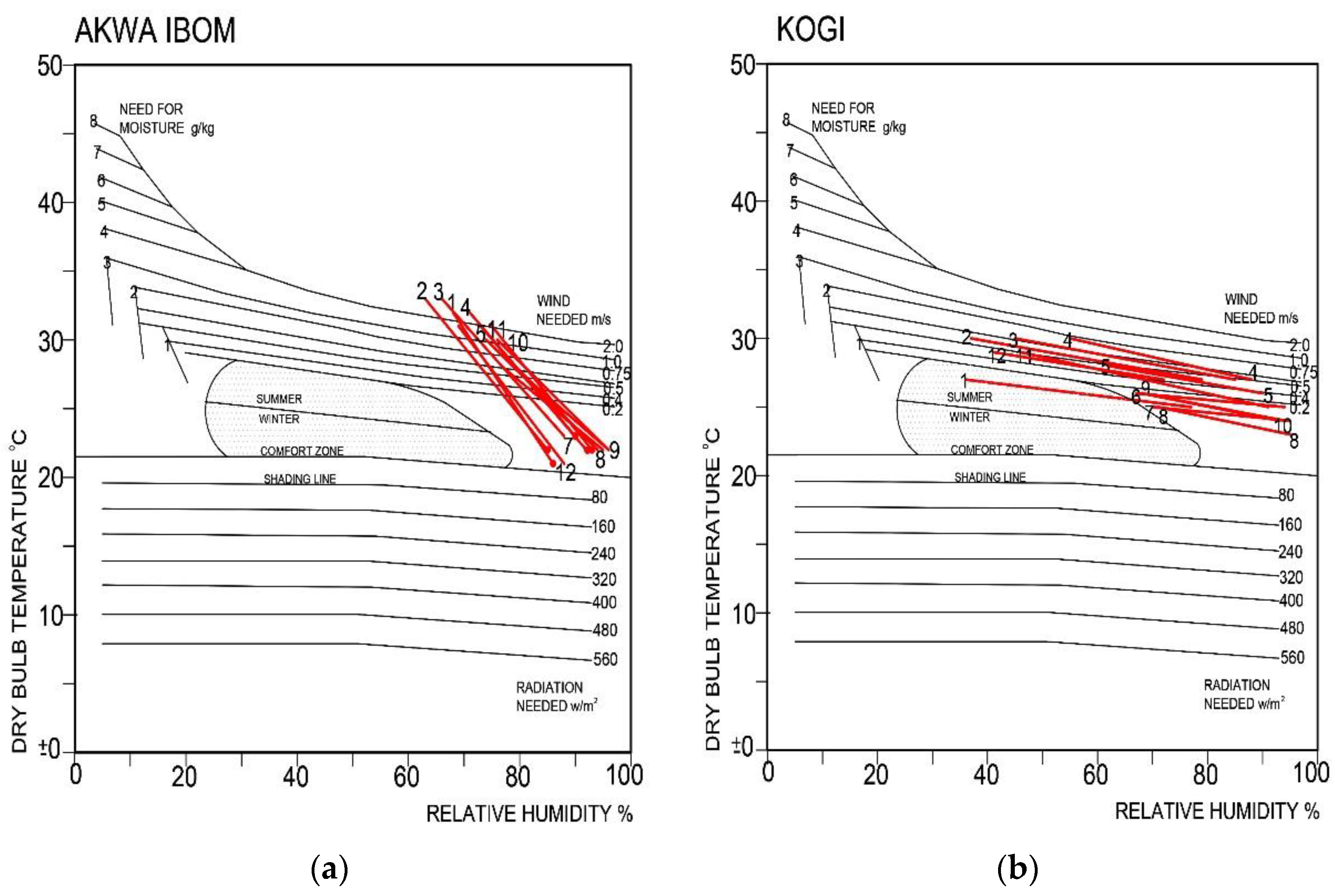
 Sustainability 12 04192 i010
Hot-Humid Climate (a) Sustainability 12 04192 i011
Cities: Cross River, Anambra, Imo, Ebonyi, Delta, Bayelsa, Ogun, Lagos, Rivers, Akwa Ibom, Abia
Bioclimatic chart Sustainability 12 04192 i012
Temperate-Humid Climate (b) Sustainability 12 04192 i013
Cities: Benue, Kwara, Oyo, Ekiti, Kogi, Osun, Edo, Ondo, Enugu
Bioclimatic chart Sustainability 12 04192 i014
Temperate-Dry With Cool Climate (c) Sustainability 12 04192 i015
Cities: Plateau
Bioclimatic chart Sustainability 12 04192 i016
Hot-Dry Climate (d) Sustainability 12 04192 i017
Cities: Sokoto, Kebbi, Zamfara, Katsina, Kano, Jigawa, Bauchi, Yobe, Borno
Bioclimatic chart Sustainability 12 04192 i018
Temperate-Dry Climate (e) Sustainability 12 04192 i019
Cities: Nassarawa, Taraba, Kaduna, Niger, Federal Capital Territory
Bioclimatic chart Sustainability 12 04192 i020

