1. Introduction
In developing and emerging economics, rapid urbanization at an unprecedented pace and degradation of ecosystem services at an alarming rate [
1,
2] have caused regions, especially those in environmentally sensitive areas (ESAs), to face the “regional development dilemma” (RDD). In the RDD, on the one hand, local governments in these regions are responsible for maintaining the functionality and integrity of local ecosystems, while on the other hand, these governments bear accountability for revitalizing the regional economy and improving the welfare of local communities.
Although urbanization is by no means bad per se [
3], rapid urbanization in developing countries and emerging economies is rarely well-planned, leading to increased poverty and deprivation [
4]. Problems of this poor urbanization, such as slum-dwellings, limited access to public services, vulnerability, environmental degradation, and climate change, are intrinsically rooted in their less developed status quo, such as economic backwardness, poor political regimes, and weak governance capacity [
5]. As such, to change the course of these regions towards a more sustainable path and achieve the Sustainable Development Goals (SDG) [
2] is more of a utopian vision rather than a feasible goal.
Ecosystem services (ES) are directly or indirectly appropriated ecosystem structures, functions, or processes that contribute to human well-being [
6]. Introduced in the early 1980s [
7,
8], this concept has received increasing appeal from politicians, policy makers, and the public, and holds great promise to act as a boundary object for sustainability; that is, it can link policy makers and different scientific disciplines via collaboration on a common task [
9].
As a type of market-based environmental policy, payment for ecosystem services (PES) is meant to facilitate more environmentally friendly actions by providing positive financial incentives to land and natural resource managers [
10,
11]. PES can help address the failure of markets to account for the value of ES in the decision-making process [
12] through communicating such value in comparison to man-made services, as well as through making the true costs of degradative activities evident [
13]. A further benefit of the PES concept is that it can provide a single common unit which can be used to condense a complex system and to compare the effects of alternative policy measures, which is a function that could be of great use to decision makers [
14,
15,
16,
17]. Last but not least, PES should not be used to set a price at which to trade nature due to often questionable commensurability, but rather they should be used as a minimum indication of the substantial benefits that ecosystems provide to humans, which should be considered in economic, political, and ecological discourse [
13,
17].
In a regional sustainability context, however, literature on PES emphasizes a common challenge: how to improve the cost-efficiency of the PES scheme. Poor targeting of ES is the main reason for the low economic efficiency and environmental effectiveness of PES schemes [
18,
19,
20,
21]. Therefore, improving the targeting of PES schemes, such as targeting special habitats or vulnerable areas, is generally recommended for increasing their cost effectiveness [
22,
23,
24,
25,
26,
27]. Consequently, targeting payments to areas where they are most needed [
28] can increase the environmental effectiveness of PES schemes.
The existing literature concerning improvements in targeting PES schemes focuses on selected individual measures. These include those related to soil conservation [
28], farm woodland schemes [
20], grassland extensification [
29], priority areas for nature conservation [
30], mountainous areas [
31], and species protection [
32,
33,
34,
35]. Moreover, there has been an increasing number of studies on ways to raise the cost-efficiency of PES, including using satellite data to target land for enrollment [
36], spatial targeting [
37], and synergies between programs [
38].
However, it is still a challenge for local governments in developing and emerging countries to improve cost-efficiency through combining different measures into coherent incentive packages at the program level [
39]. This is due to the variety of possible measures, combined with the fact that the relevant data are often gathered by independent authorities [
40] and provide insufficient empirical evidence of the ecological effects [
41].
Consequently, the aim of this study is to provide a more cost-efficient PES scheme to initiate a sustainability transformation in regions such as ESAs in developing countries and emerging economies. In this study, the water source area (WSA) of the Middle Route Project (MRP) in the South-to-North Water Diversion Project (SNWDP) in China (abbreviated as MRP) was used as the research area. The objectives of this research were to (1) estimate the ecosystem service valuation (ESV) variation in the research area under rapid urbanization; (2) provide useful information on how to determine the baseline for eco-compensation and an assurance approach for performance-based payments; and (3) propose guidelines on allocating and using eco-compensation in subregions of the WSA of the MRP—an assurance approach for improving spatial targeting of regional PES schemes.
2. Materials and Methods
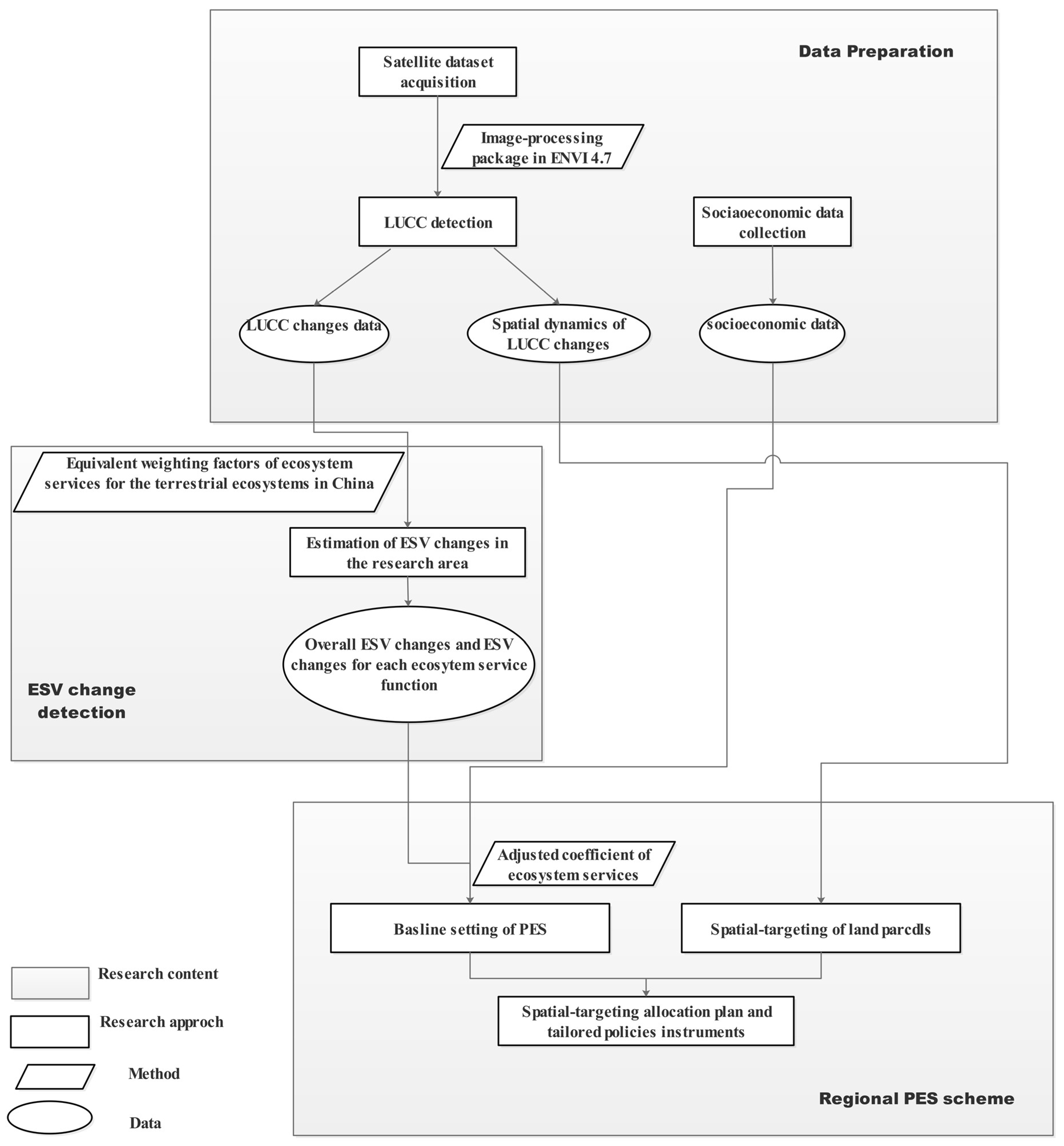
The methodological approach in this study comprises three organically linked, but mutually independent, parts (
Figure 1). The first part is for data preparation, through which the LUCC changes as well as socioeconomic data in the research area were acquired. Then, the variation trend of ecosystem service value (ESV) from the general and specific perspectives were detected. Last but not least, an innovated PES scheme for developing countries and emerging economies, with an ecosystem services (ES)-based baseline for payments and a spatial-targeting-based allocation plan, was introduced in the third part.
2.1. Background and Research Area
The Chinese government is building the USD 62 billion South-to-North Water Diversion Project (SNWDP) to divert water from the Yangtze River in southern China to the Yellow River Basin in arid northern China in order to curb the overwithdrawal of groundwater, alleviate severe water shortages in northern China, and optimize the national water resources allocation structure [
42].
After a total of investment USD 33 billion and 14 years construction, the MRP successfully passed the engineering inspections on 29 September 2014. Since then, the main focus of the central government has moved on to regional ecosystem conservation and socioeconomic development transformation towards sustainable development in the WSA of the MRP.
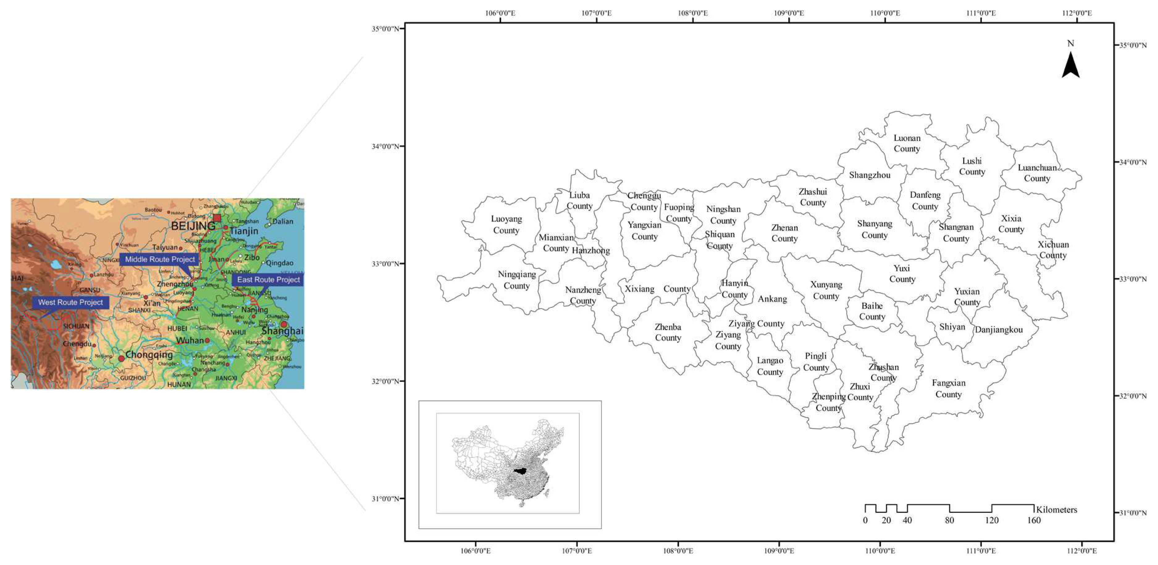
The reasons for selecting the WSA of the MRP as the research area (
Figure 2) in this study were as follows: first, the WSA of the MRP is characterized by its abundant water resources and high quality natural environment, which makes it of high value for environmental conservation; second, while this region is endowed with a relatively underdeveloped socioeconomic status and weak regional governance capability, the local governments bear great pressures to reduce poverty and improve social welfares; third, most regions in the research area were selected as a National Ecological Civilization Experimental Zone by the central government, aiming at carrying out reforms regarding the “ecological civilization system”. A series of policy experiments were initiated within this region, including establishing a natural resource property right system, compiling natural resource balance sheets, optimizing land and space planning, and incorporating ecological performance into officials’ evaluation. Thus, there are already PES-like policies deployed in this region. Therefore, this region has great potential and possibility to become a pilot zone for institutional innovation on regional PES schemes in China.
The research area (31°31′ N to 34°25′ N, 105°31′ E to 112°2′ E) occupies the upper reaches of the Hanjiang River (a tributary of the Yangtze River) and the Dangjiangkou Reservoir and includes 215 rivers with a drainage area of more than 100 km2 and 21 rivers with a drainage area of more than 1000 km2. The research area covers an area of 81,000 km2 and accounts for 66.7% of the total water resources within the Hanjiang and Danjiang River basins.
Situated at the joint zone between the North Temperate Zone and the Subtropical Climate Zone, the research area enjoys four distinctive seasons, a wet climate, and a long frost-free period (
Table 1). The research area comprises mountainous terrain (79%), hilly terrain (18%), and river valleys (3%). Given such unique geographical and climatic conditions, ecosystems in the research area are extremely fragile, with 53.8% of the area having undergone severe soil erosion, according to the results of the 2nd National Land Resource Investigation in China [
43].
The research area is associated with a poor socioeconomic status. The total population in the research area was 14 million in 2010, which is similar to Beijing and Tianjing, while the per capita GDP of the research area was approximately 20% of that in Beijing (CNY 75,943 per capita) and 21% in Tianjin (CNY 72,994 per capita) [
44,
45]. The total investment in fixed assets in the research area was less than 35% of that in Tianjin (CNY 651.14 billion) and Beijing (CNY 549 billion) in 2010 (
Appendix A).
2.2. Data
Land use/land cover change (LUCC) was obtained through an analysis of historical Landsat TM (Thematic Mapper) satellite images. All the satellite images were acquired from the USGS data base, which incorporates geometric correction and therefore can be directly used for LUCC analysis. The five steps proposed by Saadat et al. (2009) [
46] for LUCC classification were adopted using the ENVI 4.7 image-processing package. LUCC were detected in six categories (
Appendix B) in the research area from 2002 to 2010. Five-hundred ground truth points were collected using a global positioning system (GPS) in June and July 2014, and half were used for sampling and the other half for assessing the classification accuracy. The overall accuracy of the Landsat-derived land-use data as measured by kappa values was 86.34% and 85.47%, which is within the standard accuracy range of 85–90% for LUCC mapping studies as recommended by Anderson et al. (1976) [
47]. In addition, socioeconomic data of the research area was collected from the local government, as well as published official statistics books [
44,
45,
48,
49].
2.3. Ecosystem Service Value (ESV) Change Detection
The ESV variation in the research area from 2002 to 2010 was assessed by adopting the equivalent weighting factors of the ecosystem service for the terrestrial ecosystems in China by Xie et al. (2003) [
50] and the LUCC changes data over the same time frame. One unit of the coefficient in the scheme (
Table 2) is equal to the average value of the food crop produced by one hectare of cropland per year, which is proposed to be equivalent to 1/7 of the actual food production. According to Wang (2011) [
51], the ESV of one equivalent weight factor in the research area was CNY 1114.28.
Each ecosystem was then assigned one unit of ESV based on the nearest equivalent LUCC category (
Table 3). The ESV of built-up land was set as zero and the ESV of the remaining ecosystems was calculated based on their equivalent LUCC categories. The ESV of each corresponding ecosystem service function and the total ESV of the research area were calculated by the following equations:
where
,
, and
refer to the
ESV of land use category
k, the value of ecosystem function type
f (abbreviated as
ESVf), and the total
ESV of the research area, respectively.
is the area occupied by LUCC category
k, and
is the value coefficient (CNY·ha
−1·a
−1) of LUCC category
k for ecosystem service function type
f. The final value of the
ESV of each
ESVf in the research area was then obtained by averaging the
ESV of each
ESVf in 2002 and 2010.
A sensitivity analysis was performed to assess the robustness of the results. In this analysis, the ESV coefficients of forestland, grassland, cropland, wetland, and water bodies were each adjusted by 50%, and the coefficient of sensitivity (CS) was calculated using the standard economic concept of elasticity [
52].
where
is the estimated ESV;
is the value of the coefficient;
i and
j represent the initial and adjusted value, respectively; and
k represents the corresponding LUCC category. If
is greater than one, the estimated ecosystem value is elastic with respect to that coefficient. If the
is less than one, then the estimated ESV is considered to be inelastic. Larger proportional changes in ESV relative to proportional change in the value coefficient indicate that it is more critical to use an accurate ecosystem service value coefficient.
2.4. Baseline Setting of Payment and Spatial-Targeting Allocation Plan for the Regional PES Scheme
To guarantee the quantity and quality of water diverted from the research area, one key issue for the success of the PES scheme is to internalize the opportunity cost for ecosystem conservation. In this study, the baseline of the payment for ES provided by the research area was set, and the proportional share of such payment by each region benefiting from the water diverted from the research area was determined. Moreover, the spatial-targeting-based allocation plan of the PES for subregions of the research area was provided in order to improve the cost-efficiency of the PES scheme.
2.4.1. Baseline Setting of Payment for the Regional PES Scheme
An ES function is potentially beneficial at a global, national, or regional scale, and PES for such an ES function comes from global collaboration, national government, or regional PES schemes. Therefore, changes in the ESV of a certain ES function are naturally the standard used to determine the payment baseline based on the range of the potential benefit zone.
Based on the potential benefit zone of the ES function, ES in the research area can be grouped into three types according to China’s entire terrestrial ecosystem [
50]: Type I ES, with the potential benefit zone at global or national scales, including gas and climate regulation and biodiversity protection; Type II ES, including water supply and soil formation and retention, which are directly related to the quantity and quality of water resources diverted to the beneficiary region of the MRP; and Type III ES, including waste treatment, food, raw material, and recreation and culture, which predominantly benefit the local communities in the research area.
The willingness to pay for ecosystem conservation endeavors is another factor in determining the payment baseline of a regional PES scheme. Willingness to pay for ecosystem services by communities in the benefit zone corresponds with their living standard improving, as well as restrictions on their well-beings from the decrement of ES. Such a rational can be abstracted and simplified as the adjusted coefficient of ecosystem service (ACES) based on the Verhulst-Pearl formula [
53].
where
represents the ACES,
is the base of the natural logarithm, and
is the social development stage. The living standard of the residents in the benefit zone of the ES can be classified into five stages of poor, subsistence level, well-off, rich, and very rich, which corresponds to
, where
is Engel’s Coefficient [
54].
Therefore, the baseline of PES in the research area can be calculated as:
where,
indicates the baseline PES of the research area,
is the estimated amount of ESV variation in the research area,
represents the ACES, and
stands for the proportional share of the ESV of a certain ES in the research area.
After the PES baseline is determined, the proportional share of each region in the benefit zone (Henan province, Hebei province, Tianjin, and Beijing) can also be determined based on the amount of water diverted to each region, which denotes the share of the ES benefitting these regions.
where
indicates the share of the PES for each subregion,
i denotes each subregion (Henan province, Hebei province, Tianjin, and Beijing),
describes the rate of water diverted to each subregion, and
is the baseline PES for the benefiting zone of the MRP.
2.4.2. Spatial-Targeting-Based Allocation Plan for a Regional PES Scheme
The idea of spatial targeting is to target payment to land parcels with the highest degradation risk and thus to areas where payments will have the largest impact [
21]. The subregions of the research area were classified into three groups based on LUCC conversions. These comprise Group I regions, with land converted to built-up land; Group II regions, with land converted to cropland; and the remaining land comprising the Group III region. Then, regions belonging to Groups I, II, and III are geographically identified [
55] and the allocation plan of the regional PES scheme, with a special focus on Group I and II regions, can be developed and tailored with institutionally innovative approaches according to the LUCC conversion scenario.
3. Results
3.1. Variation and Spatial Distribution of ESV in the Research Area
The six LUCC categories in the research area demonstrated different spatial dynamics between 2002 and 2010. Forestland, occupying the largest area and predominantly located in the mountainous territory, decreased by 8%. At the same time, cropland, as the second largest LUCC category, increased from less than 20% to more than 25%. Water bodies and wetlands, as the two most vital LUCC categories for ES conservation and covering a relatively small area, respectively increased by 697 km2 and 947 km2. Meanwhile, grassland shrunk by 147 km2, while built-up land expanded by 1341 km2, which accounted for an average annual increment of 11%.
While the total ESV in the research area decreased by approximately CNY 6 billion between 2002 and 2010, the ESV of each ecosystem demonstrated inconsistent trends (
Table 4). Value of ecosystems proxied by cropland, wetland, and water bodies increased significantly, by CNY 4, 7, and 4 billion, respectively, while the value of ecosystems proxied by forestland faced a net decrement of CNY 21 billion. Expansion of built-up land also had a negative contribution to the total regional ESV. The annual incremental rate of the value of ecosystems proxied by water body and wetland were 10.67% and 6.73%, respectively, which were the highest increases among other ecosystems.
The ranking of ecosystem service functions (ES
f) in the research area revealed small changes in the research area (
Table 5). The top two ES
f, soil formation and retention and water supply, are critical for preserving the quality and quantity of water resources diverted from the research area. The top six ecosystem functions jointly accounted for more than 80% of the total ESV. In contrast, the ESV of food, as the lowest valued function, accounted for only 2% of the total ESV.
The southeastern portion of the research area had the highest ESV (over CNY 40,000), and included the Danjiangkou Water Reservoir and its adjacent regions, as well as some river basins (
Figure 3A,B). Regions covered by forestland accounted for the second-highest ESV (between CNY 20,000 and 40,000) and were predominantly distributed in the north along the Qinling Mountain and the south along the Bashan Mountain. Regions covered by cropland and grassland, with ESV between CNY 5000 and 20,000, were generally distributed near the urbanized areas, on plateaus in mountainous terrain or in the mountain valleys. The spatial pattern of the urbanized regions in the research area (i.e., Hanzhong, Ankang, Shiyan), with an ESV less than CNY 5000, had a more scattered distribution pattern. There were several urbanized agglomerations located in the western (Hanzhong and its adjacent urbanized area), central (Ankang and its adjacent urbanized area), and eastern regions (Shiyan and Dangjiangkou and their adjacent urbanized areas) of the research area.
The CS values of all the analyses in this study were less than 1, which indicates that the ESV estimated in this paper was relatively inelastic with respect to the ecosystem service coefficients, and therefore, the estimation of ESV variation in this research was robust.
3.2. The EC Baseline and Guidelines for EC Allocation
In China, the PES scheme is most commonly described as eco-compensation (EC), which can be understood as an economic instrument aimed at the provision of public goods [
56]. According to the variation of ESV in the research area, the EC baseline for the benefit zone of the MRP was CNY 1.1 billion.
The share of EC for water quantity and quality maintenance for each subregion in the benefit zone was determined based on principles of responsibility [
57], which, in this study, refers to the amount of water diverted to these regions. In this study, the proportional shares of the EC baseline for each beneficiary subregion of the MRP, namely, Henan Province, Hebei Province, Beijing Municipality, and Tianjin Municipality, were CNY 422.3, 388.5, 110.9, and 133 million, respectively (
Table 6).
Due to rapid urbanization in the research area, a large amount of natural area was converted to urbanized area. Regions with built-up land converted from forestland were widely scattered over the research area in relatively small urbanized agglomerations (
Figure 3C). Regions with the built-up land converted from wetland were identified in the eastern and western parts of the research area, with the two largest agglomerations situated in Zhechuan and Zhushan Counties. Regions with built-up land converted from cropland were concentrated in Ankang City and in three counties along the Hanjiang River (Hanyin, Xixiang, and Yangxian Counties). The regions with the largest area of built-up land converted from the grassland were located in Xunyang County.
The three LUCC categories that were converted to cropland in the research area were wetland, forestland, and grassland (
Figure 3D). Cropland converted from wetland was predominantly located in the western (Hanzhong city and its adjacent regions), central eastern (Dangjiangkou city and two adjacent counties to its north), and central western parts (Ankang city and its adjacent regions) of the research area along the Hanjiang River Basin. Regions with croplands converted from forestland were generally located along the Danjiang River Basin in Lushi County, which also had regions with cropland converted from grassland.
In practice, the allocation plan of the PES scheme is the product of compromise with the consideration of multiple factors—such as the local financial system, administrative hierarchy, regional administrative divisions, etc. However, this study focusses on providing guidelines for improvement of the cost efficiency of the PES scheme through spatial targeting in accordance with the ESV changes in each subregion of the research area.
Therefore, as described in the methods, the subregions in the research area were classified into three groups based on their LUCC conservation type: Group I regions, with land converted to built-up land; Group II regions, with land converted to cropland; and Group III regions, with no land converted to either built-up land or cropland.
For Group I regions, the main driver for conversion is the appeal of regional social renascence and economic prosperity for the local communities. Since such LUCC conversion is permanent and unrecoverable, the EC allocation plan for these regions should enhance restrictions on local urban expansion, improve public services and social security coverage, and promote strict environmental protection regulation. Additionally, the local industrial structure needs to be adjusted towards environmentally friendly and high-value-added forms.
For Group II regions, the EC allocation plan should emphasize two main arenas. First, financial and policy support should highlight the maintenance and restoration of high-ESV ecosystems in the research area, such as wetlands and forests. Second, local governments should facilitate the upgrading of local agricultural industries towards more high-tech and high-value added forms, as well as promote local eco-tourism projects designed based on the local natural environment and daily life and work in rural areas, such as “Happy Farmhouses” [
58] and “Picking Gardens” [
59].
For Group III regions, the EC allocation plan for these regions should highlight the maintenance and enhancement of local ecosystems. Local governments need to designate more practical policy instruments to support and facilitate regional transformation towards sustainability, such as extending the Natural Forest Conservation Program (NFCP) and the Sloping Land Conversion Program (SLCP) [
60,
61].
4. Discussion
The regional scale is broadly recognized as the most effective level for progressing sustainability [
62,
63,
64]. However, regions in developing countries and emerging economies are more likely to fall into a vicious circle wherein local governments and communities enthusiastically appeal for socioeconomic improvement at the cost of environmental degradation and deterioration. Changing the pattern of these regions from a short-term perspective of regional development towards a more sustainable path, a more advanced regional development philosophy, as well as more pragmatic and tailored policy tools, is in an urgent need, especially for regions such as ESAs in developing countries and emerging economies.
In this study, a more cost-efficient PES scheme was introduced through a policy package consisting of an ES function-based baseline setting of payments and a spatial-targeting-based allocation plan for regional PES schemes. Such PES schemes include a thorough consideration of the shortcomings of the policy tools in developing countries and emerging economies, such as sectoral segmentation, functional area mismatch, executive capacity weaknesses, and lack of skilled labor, etc. [
65]. Therefore, this approach is suitable for aiding local governments and communities in regions with less-developed or emerging economies, especially ESAs, to guide and promote a regional transition to sustainability.
4.1. Uncertainty of the Economic Value of ES
The economic value of ES, for articulating a variety of interdisciplinary measurements into one unified unit, is seen as an effective and powerful tool for decision making, particularly in developing countries and emerging economies [
66,
67]. However, putting monetary values on ES is substantially criticized due to the diversity of the human-environment system and the multifaceted socio-ecological linkages that may have an influence on the perception of societal groups on values attached to ES [
68,
69,
70,
71]. Among these critiques on monetary valuation of ES, the uncertainty of the ES value receives significant attentions [
72]. As for this study, we flagged three sources of valuation uncertainty, namely supply uncertainty, preference uncertainty, and technical uncertainty [
72].
Supply uncertainty relates to what to identify [
73], in relation to biodiversity, as uncertainties concerning “data” and “proxies”. In this study, the LUCC categories of forest, water body, grassland, and wetland can be considered with relatively higher certainty as the “proxies” of their corresponding ecosystem services, while LUCC of cropland and build-up land are considered with much higher uncertainty as the “proxies” due to their highly diverse human-environment system. In particular, urban areas are comprised of mixed nature and man-made substrates, i.e., avenue trees and artificial green space, which may lead to an undervaluation of the overall monetary value of ES in the research area.
Preference uncertainty and technical uncertainty variously link to what they define as uncertainties in “concepts”, “policy and management”, and “normative goals” [
73]. Concerns with respect to preference uncertainty in this study regard more the rationale underneath the process to develop the equivalent weighting factors of ecosystem services per hectare of China’s entire terrestrial ecosystem [
50]. Since such factors were purely based on the survey of experts and without the participation of communities from both the water resource and the beneficiary area of MRP, the evaluated monetary value of ES in the research area based on these factors is prone to involve inherent uncertainty: communities in the WSA are highly likely to treat the estimated economic value of ES they provided as underestimated, while the communities from the beneficiary area, with the opposite idea, may think the estimated economic value of ES they received is overestimated. Technical uncertainty inherent in the evaluated economic value of ES in this research comes from the inherent flaws of data sources: the LUCC change data detected from the satellite dataset may overestimate the urban area due to its relatively coarse resolution (
), while the data of Engel’s Coefficient collected from the local statistical books is prone to be smaller than the real situation in developing countries and emerging economies, which may lead to an overestimation of the baseline PES for the benefiting zone of the MRP.
4.2. Instruments for Improving Cost-Effectiveness of the PES Scheme at the Regional Scale
Compared with the PES ceiling value [
74], which was one of the critical topics in former studies [
75,
76], the method used to establish the baseline setting of payment in PES schemes in this study is more solid and tangible, and thus the approach is much easier to adopt in policy making and implementation. Moreover, the spatial-targeted allocation plan for guiding payment allocation among subregions of the research area provides more targeted subsidies and cost-effective incentives for ecosystem conservation in local communities, where regional ecosystems are more fragile or under sever interruption and receive the highest priority or most urgent need for eco-compensation.
First, determination of the baseline for payment and the allocation plan for the PES scheme in this study provided a common ground for both parties of the scheme, communities from the WSA and benefit zones of the MRP, to reach a mutual agreement on the method and amount of compensation. The main approach to PES schemes in China is “single-centered” and dominated by the central government, e.g., the Sloping Land Conversion Program (SCLP) [
77]. However, there is still a lack of policy support and implementation mechanism for PES schemes among regions with the same administrative hierarchy or belonging to the same river basin or ecoregion. One classic example is the Partnership Support Programme (PSP) (as in Chinese, “dui kou zhi yuan”). As a major form of the Horizontal Transfer Payment Mechanism (HTPM) [
78], this policy instrument was intended to stimulate the socioeconomic development of the least developed area with funds transferred from China’s most advanced regions. Nevertheless, although such an instrument is mandated by the central government with a predetermined amount and specific purpose, it is unable to fulfil the original purpose of the HTPM, which is to simultaneously improve initiatives in the ES “provider” regions for ES conservation and stimulate a transition to sustainability with the financial aids from the ES “beneficiary” regions. Therefore, the setting of a baseline payment and the allocation plan of the PES scheme introduced in this study are more suitable for both parties of PES schemes in developing countries and emerging economies to reach agreement on PES schemes with regional HTPM approaches.
Second, the rationale underlying the PES scheme in this study is to seek establishment of an alliance of interests rather than simply emphasize economic incentives. Former studies that addressed negotiation and determination of the PES scheme between the WSA and the benefit zone of the MRP were predominately from the perspectives of water resources management, public goods, economic analysis, or social-fiscal status of these regions [
79,
80]. However, the PES schemes introduced in those studies are highly risky in that they may inevitably turn the PES process into an economic controversy with “political wrangling” that may lead to mutual dissatisfaction between the two parties, which may eventually jeopardize the initial objective of those PES schemes.
Third, the process of determining the baseline payment and allocation plan in this study can facilitate the formation of bilateral communities of interest between two parties of the PES scheme, which was evolved from the unilateral beneficiary-pay principle (BPP) underlying former PES schemes [
81]. Under the former BPP-based PES schemes, the government, especially the central government, becomes the executive of the scheme, as well as the coordinator between the regions of the PES scheme beneficiary and provider in cross-province cases. Such a policy regime is often at high risk of being accused by both sides as unfair. Nonetheless, the PES scheme developed in this study has evolved from the logic of internalizing the externality to a sound regional development transformation towards sustainability initiated by the PES scheme and can also facilitate bottom-up consensus formation on ES conservation. Therefore, the PES scheme in this study can catalyze sound regional development patterns, especially ESAs, in developing countries and emerging economies, and create harmonious and win-win scenarios for regions of both the provider and beneficiary of the ES conservation.
4.3. PES Scheme Beyond Coasean and Pigouvian Conceptualization
The PES scheme that goes beyond Coasean and Pigouvian conceptualization surpasses the usual rationale of PES, where “the actual role of PES is mistakenly understood as a simple matter of financial incentives” [
82]. Initiatives of such PES schemes include the Regional Integrated Silvopastoral Ecosystem Management Project (RISEMP) [
83], the Rewarding Upland Poor for Environmental Services (RUPES) [
84], and the Reduced Emissions from Deforestation and Degradation (REDD) program [
85], which have been implemented in many developing countries. Although endeavors from international institutions (the World Bank, International Fund for Agricultural Development, World Agroforestry Centre, United Nations Framework Convention on Climate Change) still require improvement, these schemes have had remarkable effects on leveraging regional development transformation towards sustainability through economic initiatives, as well as institutional innovations [
86,
87].
As a broader concept than PES and more strongly emphasizing the institutional and political aspects of payments, China’s PES schemes, as prescribed in terms of eco-compensation (EC), embody a great potential for institutional and regulatory innovation for bridging and achieving SDG 8 “Decent Work and Economic Growth” and SDG 15 “Life on Land” on a regional scale. EC in China encompasses both PES-like polices in terms of payments (direct payment from the government to individual and community level suppliers of ES), and policies for developing a framework to coordinate the government at different levels to share the costs of environmental protection and restoration [
65].
As for this study, most regions in the research area are enlisted in the pilot zone of the National Ecological Civilization Experimental Zone, which considers and addresses resource and environmental issues from the ideal of an ecological civilization and emphasizes the incorporation of ecological progress with economic, political, cultural, and social advancement. A major mission for these regions is to stress the system and mechanism of innovation, as well as the guidance and promotion, of policies and regulations within the region to meet the goal of achieving harmonious development between man and nature and building a “beautiful China”.
Therefore, the ESV-based methodology adopted in this study, with the ES function-based setting of baseline payments and spatial-targeting-based allocation plans for regional PES schemes, offers an innovative and practicable tool for determining and formulating the amount and procedures of regional PES schemes. Moreover, setting a baseline EC payment and formulating tailored allocation plans provide an economic guarantee and operational countermeasures for stimulating regional development transformation towards sustainability. The PES scheme in this study, instead of setting a price to trade with nature, incorporates the substantial benefits that an ecosystem provides to humans, which need to be considered in economic, political incl. legal, and ecological discourse [
13,
88,
89,
90,
91].
Thus, the approaches in the PES scheme introduced in this study, designed in the context of underdeveloped and emerging economies, provide powerful instruments for simultaneously employing multiple development targets, which provides a prerequisite for bridging regional SDG 8 and SDG 15 in regions from developing countries and emerging economies.
5. Conclusions
The regional scale is broadly recognized as the most effective level for progressing sustainability [
62,
63,
64]. The main research focus of this study is to introduce a PES-scheme policy instrument that determines an ES function-based baseline for payments and a spatial-targeting-based allocation plan to address the regional development dilemma that is prevalent in developing countries and emerging economies, especially in ESAs.
According to this study, rapid urbanization has a substantial impact on the spatial dynamics and quality of ecosystems in the WSA of the MRP of the SNWDP in China. The overall ESV in the research area declined by CNY 6 billion from 2002 to 2010. This reduction was caused by the decrement of ESV in the ecosystem proxied by forests, as well as the expansion of build-up land, and was only partly offset by the increment of ESV of ecosystems proxied by arable land, water bodies, and wetland. Therefore, according to the potential benefiting scope of ESf, the baseline payment of the PES scheme from the benefit zone to the research area was set at CNY 1.1 billion. Responsibility ought to be shared by Henan and Hebei provinces, and Beijing and Tianjin, with payments of CNY 422.3, 388.5, 110.9, and 133 million, respectively. Furthermore, based on the spatial pattern of ESV variation and LUCC transformation, an allocation plan for the research area was drafted that aimed to spatially target regions with the most PES cost-efficiency. For regions with land converted to built-up land, the PES scheme for these regions should enhance their restrictions on urban area expansion, continue to improve the level of public services and social security coverage, and promote strict regulations for safeguarding the local environment; for regions with land converted to cropland, the allocation plan for these regions ought to focus on the restoration of high-ESV ecosystems (e.g., wetlands and forestland), facilitation of upgrading local agricultural industrialization, and promotion of eco-tourism in terms that fit the local customs and practices; for the remaining regions in the research area, the allocation plan should highlight maintenance and enhancement of the local ecosystems and support and facilitate regional development transformation towards more sustainable fashion.
The methodology and instruments presented in this study are of particular value to researchers, as well as for regional PES schemes, in developing countries and emerging economies that are aimed at leveraging regional sustainability through bridging and achieving SDG 8 and SDG 15. However, given the heterogeneity of ESAs in developing and emerging economies due to their diverse natural ecosystems and social-ecological systems, adoption of this methodology and instruments in these regions still requires a thorough consideration of the differences involved, as well as tailored and targeted adjustments. Moreover, as for the PES scheme per se in this study, there is still substantial room for improving its applicability—but notwithstanding acknowledging the uncertainties connected with the application of the PES method in connection with large-scale projects [
92,
93]—in leveraging regional sustainability by, for instance, designing sophisticated allocation methods and developing performance-based allocation plans and assessment mechanisms.


