Article

Understanding Dynamics of Mangrove Forest on Protected Areas of Hainan Island, China: 30 Years of Evidence from Remote Sensing

1
Key Laboratory of Digital Earth Science, Institute of Remote Sensing and Digital Earth, Chinese Academy of Sciences, Beijing 100094, China
2
Key Laboratory of Earth Observation Hainan Province, Sanya 572000, China
3
University of Chinese Academy of Sciences, Beijing 100049, China
4
School of Biological, Earth and Environmental Sciences, University of New South Wales, Sydney 2052, Australia
*
Author to whom correspondence should be addressed.
Sustainability 2019, 11(19), 5356; https://doi.org/10.3390/su11195356
Submission received: 4 July 2019 / Revised: 13 September 2019 / Accepted: 26 September 2019 / Published: 27 September 2019

Abstract

:
Implementation of the UN Sustainable Development Goals requires countries to determine targets for the protection, conservation, or restoration of coastal ecosystems such as mangrove forests by 2030. Satellite remote sensing provides historical and current data on the distribution and dynamics of mangrove forests, essential baseline data that are needed to design suitable policy interventions. In this study, Landsat time series were used to map trends and dynamics of mangrove change over a time span of 30 years (1987–2017) in protected areas of Hainan Island (China). A support vector machine algorithm was combined with visual interpretation of imagery and result showed alternating periods of expansion and loss of mangrove forest at seven selected sites on Hainan Island. Over this period, there was a net decrease in mangrove area of 9.3%, with anthropic activities such as land conversion for aquaculture, wastewater disposal and discharge, and tourism development appearing to be the likely drivers of this decline in cover. Long-term studies examining trends in land use cover change coupled with assessments of drivers of loss or gain enable the development of evidence based on policy and legislation. This forms the basis of financing of natural reserves of management and institutional capacity building, and facilitates public awareness and participation, including co-management.

1. Introduction

Mangrove forests are a diverse assemblage of trees and shrubs that occupy intertidal wetlands of tropical and subtropical regions of world [1]. The forests are ecologically and socio-economically important, and provide a wide range of supporting, provisioning, regulating, and cultural ecosystem services (e.g., shoreline stabilization, reduction of coastal erosion, storm protection, sediment and nutrient retention, water filtration, provision of medicinal plants and construction material, tourist attraction) [2,3,4,5,6,7,8]. In recent years, the role of mangrove forests in protection from natural disasters and carbon sequestration has being highlighted as an effective option for climate change adaptation and mitigation. At the same time, mangrove forests are vulnerable ecosystems, being under threat from both natural and anthropogenic forces [9,10,11], and efforts towards their conservation, protection, and sustainable management and restoration are central to the achievement of UN Sustainable Development Goals (SDGs) such as 14, 15, and 6.6 [12]. Access to up-to-date, complete, and accurate information regarding the spatial distribution and change dynamics of mangrove forests is essential for baseline and target setting of these SDGs, and for tracking the impact of actions implemented by governments at national or local levels to progress towards set targets.
Remote sensing is a widely used tool for the provision of spatio-temporal information regarding mangrove forest distribution, species differentiation, health status, and dynamic changes at landscape level [13,14,15]. Extensive prior research has documented the potential and limitations of using optical imagery (e.g., aerial photographs, high- and medium-resolution satellite images, hyperspectral data), and active synthetic aperture radar (SAR) data for mangrove studies [16,17,18,19,20], ranging from local to global scales [21,22]. Worth noting are 2000 global scale mangrove forest maps from Spalding et al. [23] and Giri et al. [1]; and the Global Database of Continuous Mangrove Forest for the 21st Century (CGMFC-21) produced with data from the years 2000–2012 [24]. These works have enhanced understanding of mangrove forest biodiversity and potential as carbon stocks, and are an aid to global policy- and decision-making for the management, conservation, and sustainable use of these ecosystems.
In China, mangrove forests dominate the southeast coast of China, across the provinces of Guangxi, Guangdong, Fujian, Hainan, and Taiwan. The spatial distribution of this ecosystem has been mapped at local and national scales [25,26,27,28,29,30,31,32,33,34] at specific points in time, hence unable to reflect change dynamics of the mangrove forests. Furthermore, these estimates vary depending on the scale of mapping (i.e., national or provincial scale).
Increasing fragmentation of mangrove forests along the coastline due to natural and human disturbances makes challenging to accurately map the distribution and dynamics of this ecosystem in places such as Hainan Island, the second largest island in China. The island has wide distribution of mangrove forests, and high species-richness; and despite government efforts for their conservation and protection, significant changes have occurred in recent years due to the impact of human activity and rapid economic development. Hence an approach enabling dynamic monitoring of mangroves’ distribution and state is essential to formulate effective ecological policies in Hainan. To this end, this research assesses the potential of applying a multitemporal mapping approach that combines support vector machine (SVM) technique and visual interpretation to generate mangrove forest maps over seven protected areas of Hainan Island at seven epochs between 1987 and 2017 (see Section 2.3). The performance of the methods was evaluated alongside ground survey data and other publicly available mangrove forest data. Moreover, the possible reasons causing mangrove forest changes were analyzed through coupling the results of the multitemporal classified Landsat imagery with a conceptual framework of pressure-state-response (PSR).

2. Materials and Methods

2.1. Study Area and Data Sets
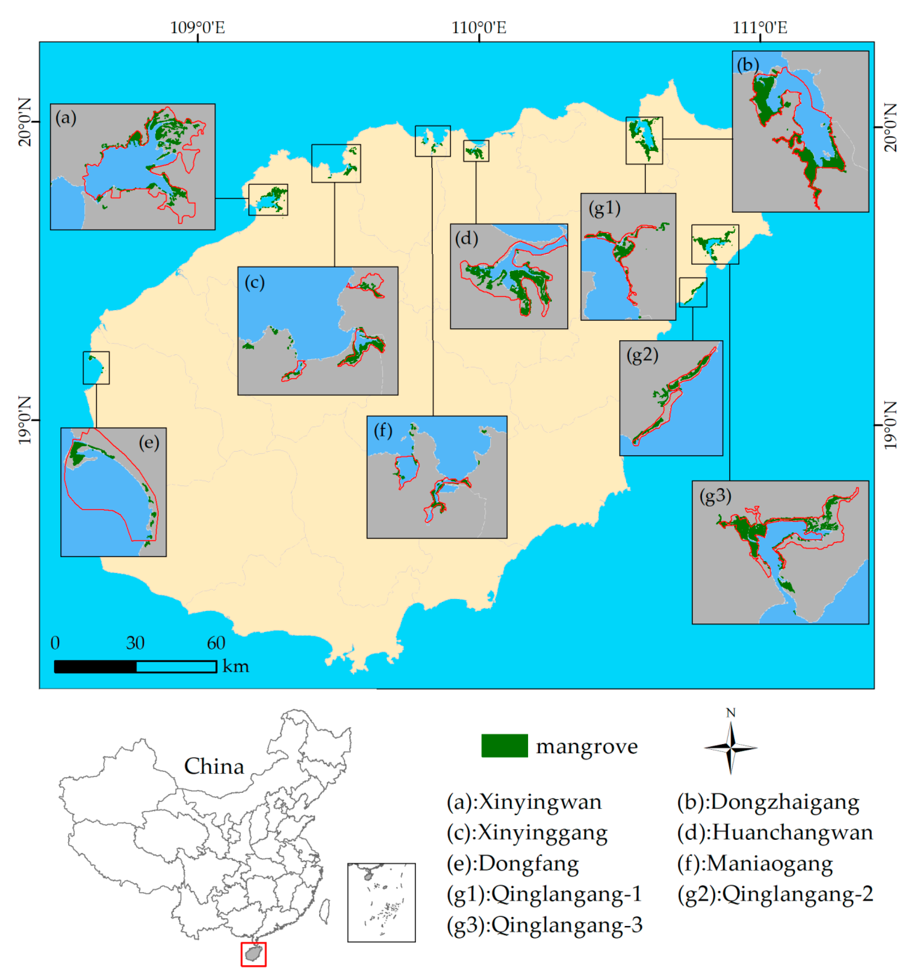
2.1.1. Study Area

Mangroves on the island of Hainan are located mainly in the northeastern, southern, eastern, and western coastal areas, such as Haikou, Wenchang, Danzhou, Sanya, Lingao, Chengmai, and Dongfang. The forests are rich in plant species, including true and semi-mangrove species. There are 36 mangrove species on Hainan Island [35]. Since the 1980s, China has made rapid progress in mangrove conservation. Eight mangrove nature reserves located in Dongzhaigang, Qinglangang, Xinyinggang, Xinyingwan, Huachangwan, Dongfang, and Sanya, have been established, with a total protected area of more than 9600 ha. Seven of the eight declared mangrove reserves along Hainan’s coastal area were selected to conduct the study (Figure 1).
Among the selected nature reserves, Dongzhaigang National Mangrove Reserve (DNMR), listed as a Wetlands of International Importance (Ramsar Site 53), has the largest area of coastal tidal mangrove forests, and it presents the most continuous, best-preserved mature mangrove forest of China. Qinglangang Nature Mangrove Reserve (QNMR) was established as a provincial nature reserve, and consists of three sections located in different sites. Dongfang Nature Reserve was also declared as the provincial reserve, and the other four were delegated as local nature reserves. Table 1 presents the details of the selected reserves, including the year they were declared protected areas and the authorities responsible for their managements. These reserves, including a 2 km buffer zones were chosen as the study area. The boundaries of selected reserves were delineated referring to the previous studies [36,37,38], and the management agencies supplied the boundaries of DNMR and QNMR [39,40]. The buffer zones were delineated 2 km from the boundary of protected areas.

2.1.2. Data Sets

This research uses multitemporal series of Landsat images at 30 m spatial resolution, to monitor long-term (1987–2017) changes in mangrove forests. To this end 31 cloud-free Landsat images, including 21 Landsat Thematic Mapper (TM) and Enhanced Thematic Mapper Plus (ETM+) images, and 9 Landsat Operational Land Imager (OLI) images (see Table S1) were downloaded from the United States Geological Survey (USGS) Center for Earth Resources Observation and Science website [41]. Most images were acquired at tidal heights of less than 2 m, when most of the mangrove forests are not inundated. Figure S1 shows the coverage of Landsat images for the study area.
Ground surveys were conducted on Hainan Island in November 2016, March 2017, and January 2018. Google Earth images were used to plan the field work that collected information on mangrove species, growth status, and the surrounding environments. A total of 386 ground observations were performed, with 152 points located in mangrove ecosystems and 234 points on other land cover types (built-up areas, cultivated land, other forests, aquaculture ponds, water body, bare land, and tidal sand flats) present within the selected study areas (Figure 2).

2.2. Understnading Mangrove Dynamics thorugh the PSR Framework

To understand dynamics of mangrove forest on protected areas of Hainan Island, a PRS (pressure-state-response) conceptual framework was proposed, exploring drivers of mangrove changes, associated pressures, and the consequences on the state of the ecosystem at the selected sites (Figure 3). In the conceptual framework, pressures that drove the mangrove changes include natural factors and human activities. Major categories include clearing for aquaculture, wastewater disposal and discharge, rapid tourism development, invasive species and diseases, and natural phenomena (e.g., sea-level rise, tropical storms, etc.). Prior research ascertains that as a transitional intertidal ecosystem, mangrove forests are particularly vulnerable to climate change stressors, such as sea-level rise [42] and drought [43], where changing environmental conditions push mangroves beyond species-specific thresholds of tolerance [44].
The pressures arising from human activities or natural phenomena impact on the state of mangroves through increases fragmentation, habitat loss, and/or degradation. Responses are identified from implementation of government policies, strengthening of the reserve management and public awareness raising on socio-economic significant of mangrove forests.
For example, the mangroves located in Qinglangang are the most diverse in China, while the Dongzhaigang’s mangrove are a well-known touristic attraction. An ecosystem health index (EHI) undertaken for Dongzhaigang Mangrove nature reserve [45], identifies pressures in the form of ongoing human activities (e.g., tourism, marine water pollution arising from state farms and domestic sewage, aquaculture farms; the overuse of groundwater supplies, and excessive harvesting of mangrove species of economic value), and consequences of past, such as former construction of dams. The project [45], with a focus on strengthening effectiveness in the management of mangroves, suggests responses to: reduce communities’ pressure and reliance on the natural capital of the reserve; promote sustainable harvesting, and; co-manage the reserve to develop alternative livelihood (e.g., ecotourism). In this regard, time series of satellite remote sensing data can provide insights to identify proxies of pressures, indicators of state and change of state, and through regular monitoring, the success of responses.

2.3. Remote Sensing Data Processing

Radiometric calibration and atmospheric corrections were performed on the Landsat images using the FLAASH module [46] within the Environment for Visualizing Images (ENVI) software (version 5.3, Boulder, CO, USA). Georeferenced Landsat OLI images from 2017 were used as master “spatial reference set” to rectify time series of Landsat for the years 1987, 1993, 1998, 2003, 2007, and 2013. Co-registered images had an average root mean square error (RMSE) of less than 0.5 pixel.
A SVM classification technique [47] was applied to separate mangrove from non-mangrove areas in the selected reserves, on the 2017 Landsat OLI images. This machine learning method locates an optimal hyperplane that maximizes the margin between two classes in high-dimensional space, and it has been successfully applied for classification of land covers from remotely sensing imagery [48,49,50]. This research applied a radial basis function (RBF), and set the penalty factor to 100, and the Gamma function to 0.022.
Visual inspection of the results was undertaken through a combination of field data and Google Earth images, and used to assess completeness and reliability of mangrove areas mapped by applying of the SVM classifier on the 2017 Landsat OLI images. In a subsequent step, mangrove and non-mangrove areas were screen digitized from historical Landsat images (1987, 1993, 1998, 2003, 2007, and 2013) using the 2017 Landsat OLI mapped mangrove areas as contextual reference base. The classified 2017 image was used as reference for digital visual interpretation of mangrove forests on images of preceding years. These results were trusted as accurate because field surveys were conducted contemporaneously with the 2017 image acquisition and used for validation of mapped mangrove areas (see Table 2). Previous studies have reported that visual interpretation as undertaken in the context of this research is not uncommon, and highlight its benefits [51,52].

2.4. Accuracy Assessment

Mangrove and non-mangrove land cover validation samples were generated for the seven mangrove forest reserves using the National Oceanic and Atmospheric Administration (NOAA) Biogeography Branch’s Sampling Design Tool for ArcGIS [53]. Considering the 30 m spatial resolution of the Landsat image, a circular buffer with a radius of 9 m (i.e., smaller than one pixel) was produced around each validation point sample, and a rectangular polygon was created based on the circular buffer using the ArcGIS software (version 10.0, Redlands, CA, USA). These polygons were classed as mangroves and non-mangroves by reference to Google Earth images and field survey data. Finally, these polygons were used to assess the accuracy of areas mapped as mangrove in the time series Landsat images. An error matrix providing overall accuracy (OA), user’s accuracy (UA), producer’s accuracy (PA), and Kappa coefficient was used produced to assess agreement between the ground-truth data (field survey and Google Earth images) and the classified images.
Furthermore, a search was conducted to identify and compile prior research that mapped mangroves at a point in time within the interval of 1987–2017 over the seven study sites. Six reports were identified that mapped mangrove areas in years 2015, 2013, 2010 and 2000 and used to assess the similarity in estimations of mangrove areas.

3. Results

3.1. Accuracy Assessment of Mangrove Areas

The accuracy of mangrove areas extracted from the 2017 Landsat images was assessed using a total of 650 check points (300 mangrove points, and 350 points corresponding to land cover types other than mangroves). These check points include ground observations and sampling points generated by Google Earth images. Table 2 summarizes the OA, UA, PA, and Kappa coefficient of the classification results for the 2017 Landsat images, indicating a 98% Kappa agreement.

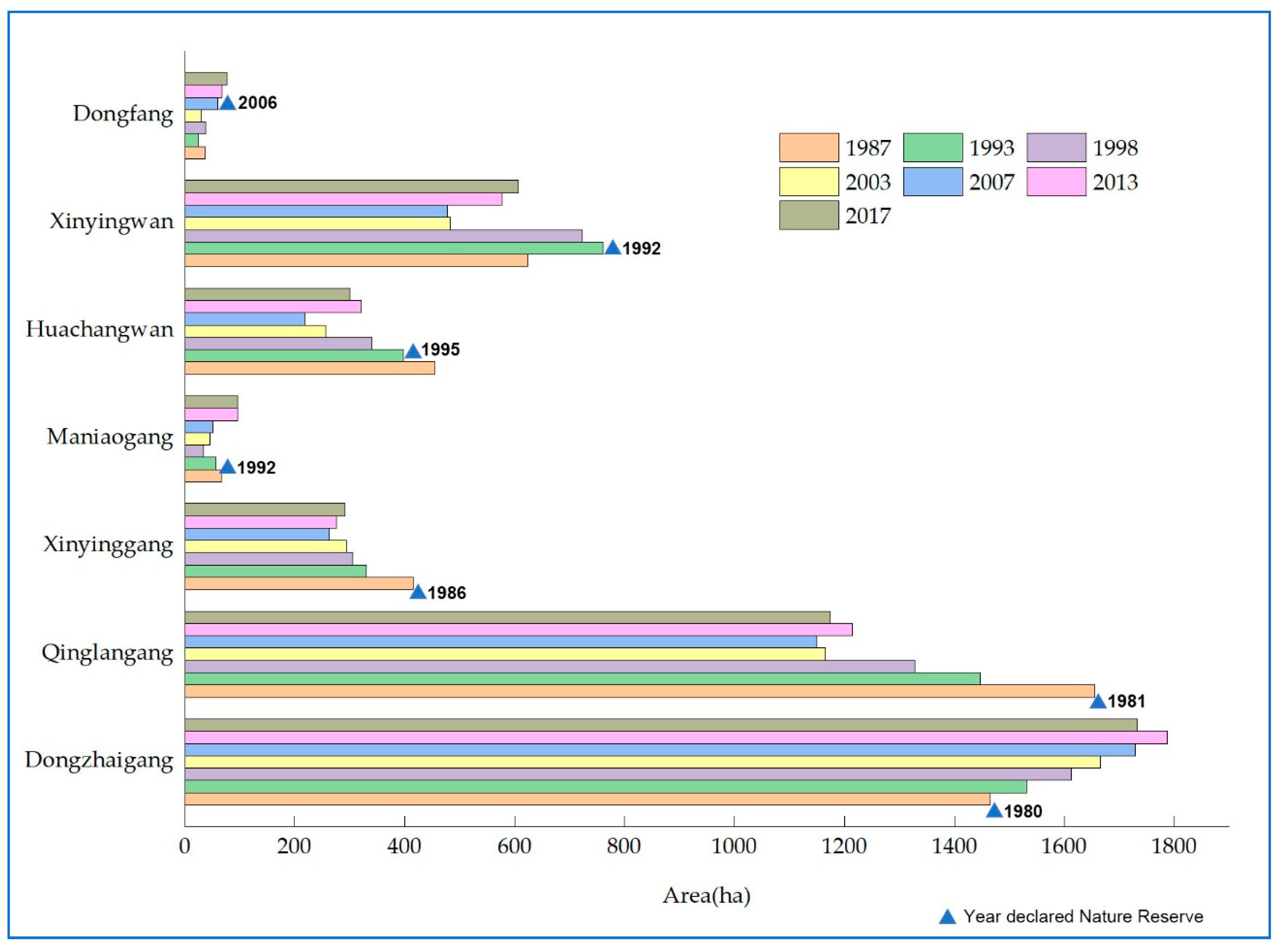
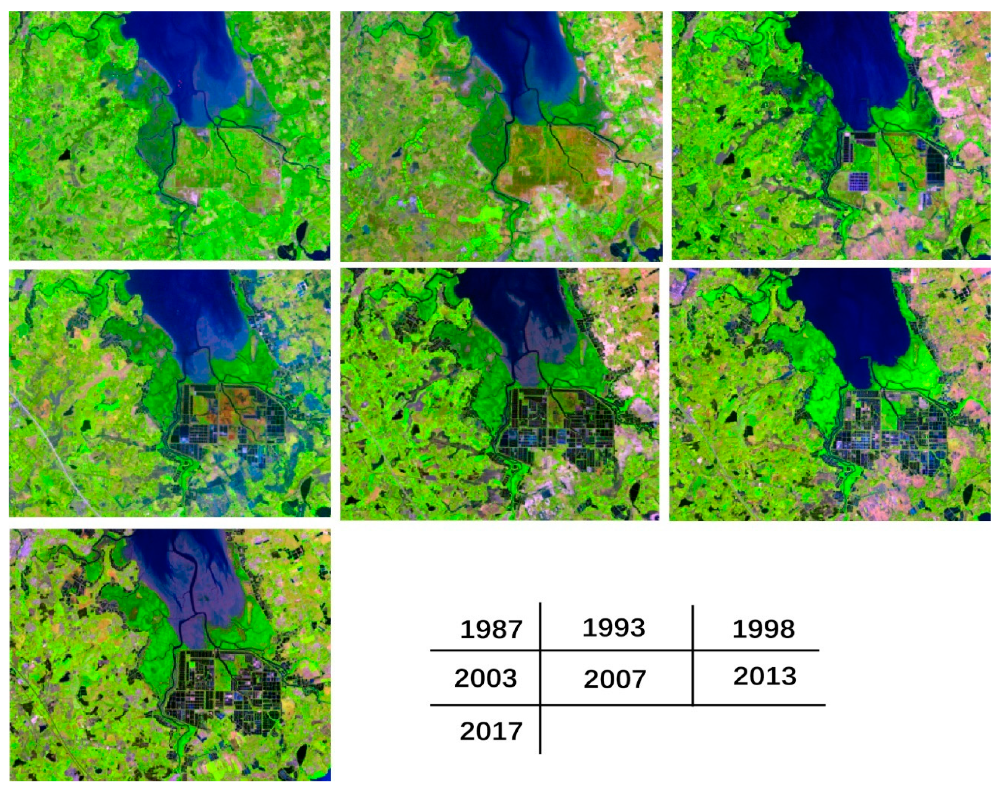
3.2. The Distribution of Mangrove Areas on Selected Protected Areas of Hainan Island

The total area of mangrove forests at seven sites on Hainan Island was computed from the classified Landsat images from 1987 to 2017. Table 3 presents the average annual amount of mangrove forest mapped at each site from 1987 to 2017, and Figure 4 portrays the total annual extent (in hectares) of mangroves at an interval of six years. A decreasing trend in mangrove areas can be observed between 1987 and 2003, followed by a five-year plateau with an increasing trend in mangrove coverage between 2007 and 2013. A slightly negative trend is observed between 2013 and 2017.
Table 3 summarizes the total area (hectares) for each of the selected protected areas from 1987 to 2017, at a six-year interval. Dongzhaigang National Mangrove Reserve in Haikou, and Qinglangang Nature Mangrove Reserve in Wenchang (see Figure 1), account for more than 60% of the total mangrove forest cover on selected protected areas of Hainan Island, with the remaining five sites representing less than 40% of the total mangrove area. Figure 5 illustrates the annual variation in mangrove cover at the protected areas Hainan Island, as derived from the classification of the multitemporal Landsat images over 30 years, from 1987 to 2017.
Table 4 compares estimations of mangrove areas in the seven reserves by prior research with results from the time series Landsat analysis presented in Section 3.2. Comparisons are against annual closest annual estimations produced in this research. Mangrove forest map of China (MDFC) 2015 was compared again the 2017 estimations. Jia (2013) and Zhang (2013) compare with the results for 2013. Mangrove forest map of the world (WMF) 2000 and World Atlas of Mangroves (WAM10) 2000 compare with 2003 estimations, and Wu (2010) was compared against the 2007 results.

4. Discussion

4.1. Accuracy of Multitemporal Mangrove Dynamics Mapping

The multitemporal classification of Landsat images covering a time span of 30 periods offers a new insight into the dynamics of coastal mangrove change on nature reserves of Hainan Island. The support vector machine technique delivered accurate discrimination of mangrove areas (overall accuracy of 99%) that could be used with high confidence to undertake visual interpretation of historical images. Furthermore, comparison with prior estimations from independent research (Table 4) for the years 2015, 2013, 2010, and 2000 shows a good level agreement with estimations of year 2000 and 2010.
At the local level, for 2013 our study detected more forests in Dongzhaigang nature reserve than Zhang’s work (1673 ha), but less than Jia (1975 ha). Likewise, for the same reserve, the comparison of our results (year 2003) with estimations of year 2000, shows values similar to WMF (1666 versus 1629 ha). For the Qinglangang reserve, results are similar between year 2003 (1165 ha as shown in Table 3) and year 2000 mapped by the WAM 10 (1108 ha). The 2003 areas of mangrove forests in Xinyinggang, Xinyingwan, Huachangwan and Maoliaogang differed from the results of WMF and WAM 10 (see Table 3 and Table 4), though similar for the Dongfang Nature Reserve.

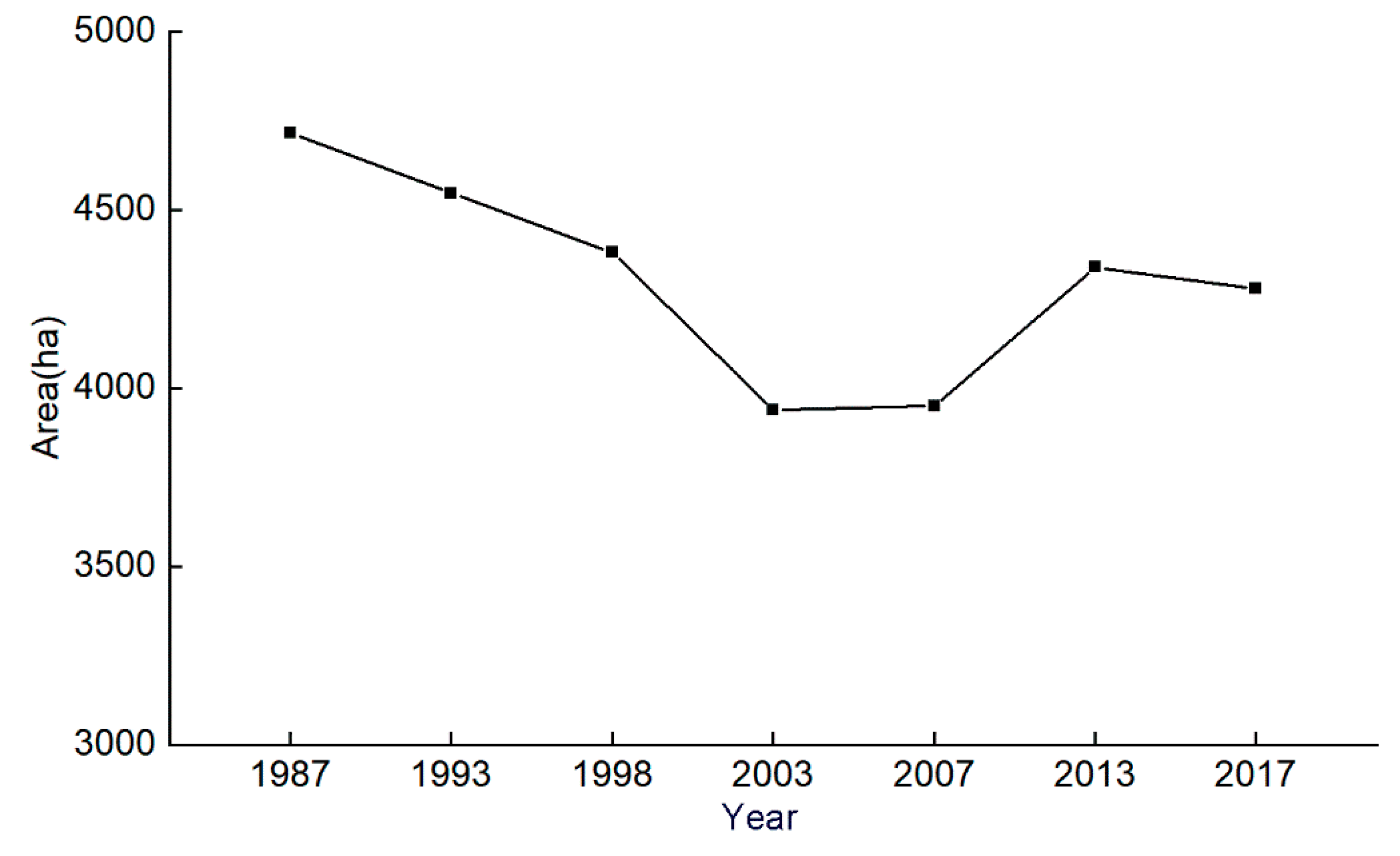
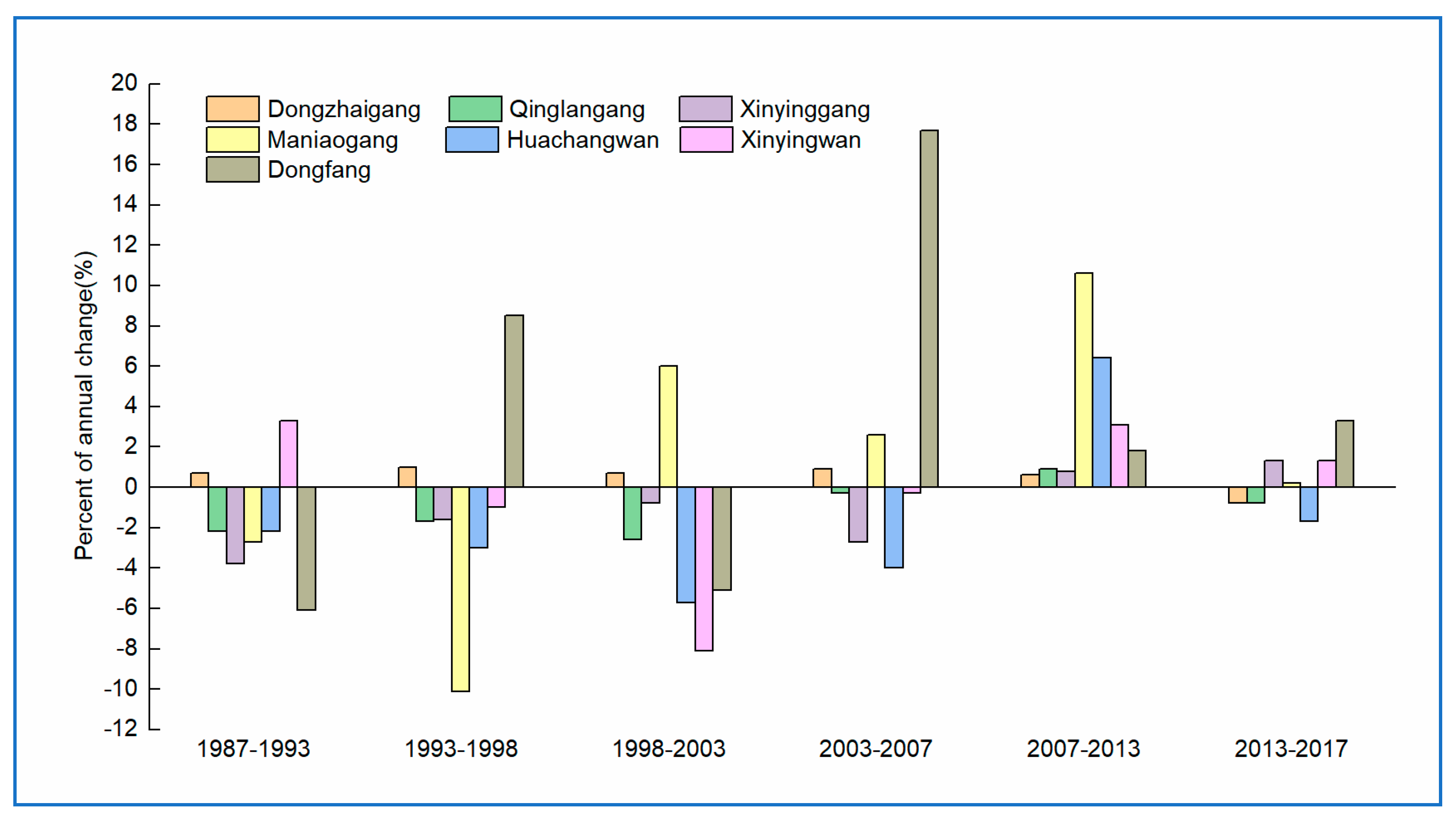
4.2. Trends in the Area of Mangrove Forest at Selected Sites on Hainan Island

The results (see Table 3) evidence an overall net decrease of 9.3% in mangrove forest (from 4716 to 4278 ha) over the 30 years of Landsat-based monitoring on the Hainan Island. The largest loss of mangrove forests occurred between 1998 and 2003, equating 88.2 ha y−1, followed by an annual average loss of 33.2 ha y−1 between 1993 and 1998, and 28.1 ha y−1 (1987–1993), and 15.3 ha y−1 between 2013 and 2017. The extent of mangrove forests remained stable between 2003 and 2007, with the highest annual increase rate (65.0 ha y−1) observed between 2007 and 2013.
Figure 6 shows the conversion between mangroves and other land cover types in Hainan protected areas from 1987 to 2017. During this period, mangrove forests were converted into other land cover types, including 1065 ha for aquaculture ponds, 7 ha for bare land, 46 ha for building-up areas, 42 ha for cultivated land, 158 ha for other forests, 31 ha for tidal sand flats, 153 ha for water body, and 79 ha for wetland. Likewise, land cover types, such as aquaculture ponds, cultivated land, other forests, tidal sand flats, water body, and wetland, etc., changed to mangrove forests. This indicates that mangrove forests on Hainan Island were transformed to other land use due to the impact of human activities, especially the excavation of aquaculture ponds. Furthermore, some mangrove areas experienced persistent environmental degradation, which caused changes to water bodies and tidal sand flats.
Figure 7 shows trends in the annual change in mangrove area from 1987 to 2017 at each of the seven reserve areas. The extent of mangrove areas at the Dongzhaigang reserve increased steadily over 26 years (1987–2013). This trend may be related to a positive impact on mangrove conservation and sustainable management underpinned from Hainan government strategies such as the 12th Five-Year National Development Plan (2011–2015); and from international aid funded programs for capacity building and co-management developed between 2007–2012 (e.g., AUSAID supported implementation of a project for capacity building on management and policy in Dongzhaigang, described in UNDP-GEF 2013). Actions to deploy the Five-Year-National Plan in Hainan consists of improving management effectiveness of the Dongzhaigang Nature Reserve, including development of institutional capacity, and plans to extend wetland protection and restoration through creating the Hainan Dongzhaigang National Wetland Park, Haikou Nandujiang Estuary Provincial Wetland Park and Haikou Baishuitang City-level Wetland Park. Our results (Figure 6) also evidence a renewed loss of mangrove areas between 2013 and 2017. The latter has also been reported in research of Sun et al. [55] and attributed to terrestrial sources of pollution, including heavy metals [56]. Other factors may have also contributed to the loss in mangrove area at this reserve. More to the point, a break-out of Sphaeromawalkeri in 2010 affected 5.39 ha [57,58,59], and July 2014 typhoon “Rammason” damaged the mangrove forests in Dongzhaigang and Qinglangang reserves [60,61,62].
Significant losses of mangrove habitat have occurred at Qinglangang reserve from 1987 to 2007, despite the area being declared a nature reserve in 1981 (Figure 5). A 2013 EHI study on Qinglangang reserve (UNDP-GEF, 2013) ascertains the site experiences intensive human-induced pressure from local communities due to rapidly increasing tourism, fishing activities. Our results appear to confirm the negative impacts of these pressures on the areal extent of mangroves at the reserve. The multitemporal analysis of the Landsat imageries also indicates the negative trend reversed between 2007 and 2013, followed a new wave of habitat loss between 2013 and 2017 (Figure 7).
The loss of mangrove forests in Xinyingwan reserve was most significant between 1998 and 2003, reaching 47.9 ha y−1. That trend began to reverse between 2003 and 2007 (no significant loss of mangrove forests was observed as shown in Figure 5 and Figure 7) with a positive increase over the period 2007–2017. Similar patterns of change can be observed in the Reserves of Xinyinggang and Huachangwan Reserves for 26 years; both locations exhibit a decreasing trend in mangrove coverage from 1987 to 2007 that reverses over the next five years (2007–2013), with a sustained increase between 2013 and 2017 only for the Xinyinggang reserve. The latter was created in 1986 (Figure 5) as a county level nature reserve with no baseline survey, and at 2012 it was lacking an official administration unit, and had only one permanent staff responsible for patrols (UNDP-GEF, 2013). Dongfang area was declared a nature reserve in 2006 and the multitemporal mapping of mangrove habitat (Table 3 and Figure 5) shows a small, though steady, increase in mangrove surface area since 2007. The Maniaogang area, declared a reserve in 1992, follows a similar dynamic of small and steady increase in mangrove areas since 1998. Large-scale direct destruction of mangrove forests has rarely occurred in the west coast of Hainan Island due to the declaration of the Nature Reserves [63].
Figure 5 and Figure 7 summarize the dynamics of mangrove change in seven reserves of Hainan Island and the temporal trends of habitat loss and recovery mapped thorough the use of 30 years of Landsat imagery adds strong evidence to the impacts of effective management on reserves once established.

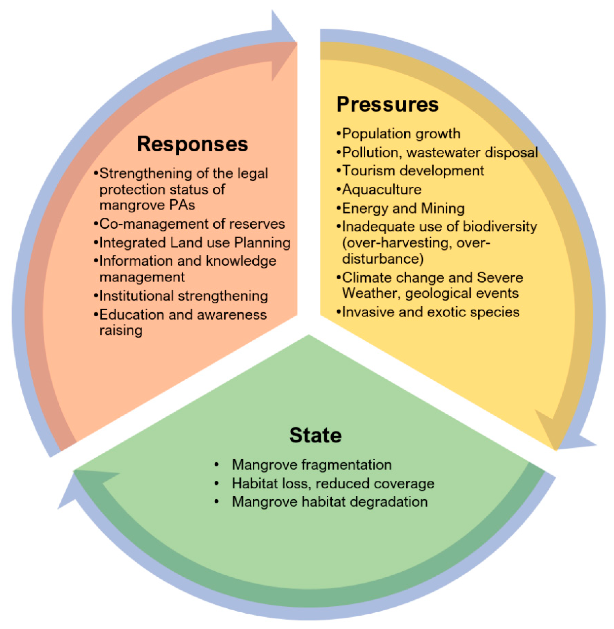
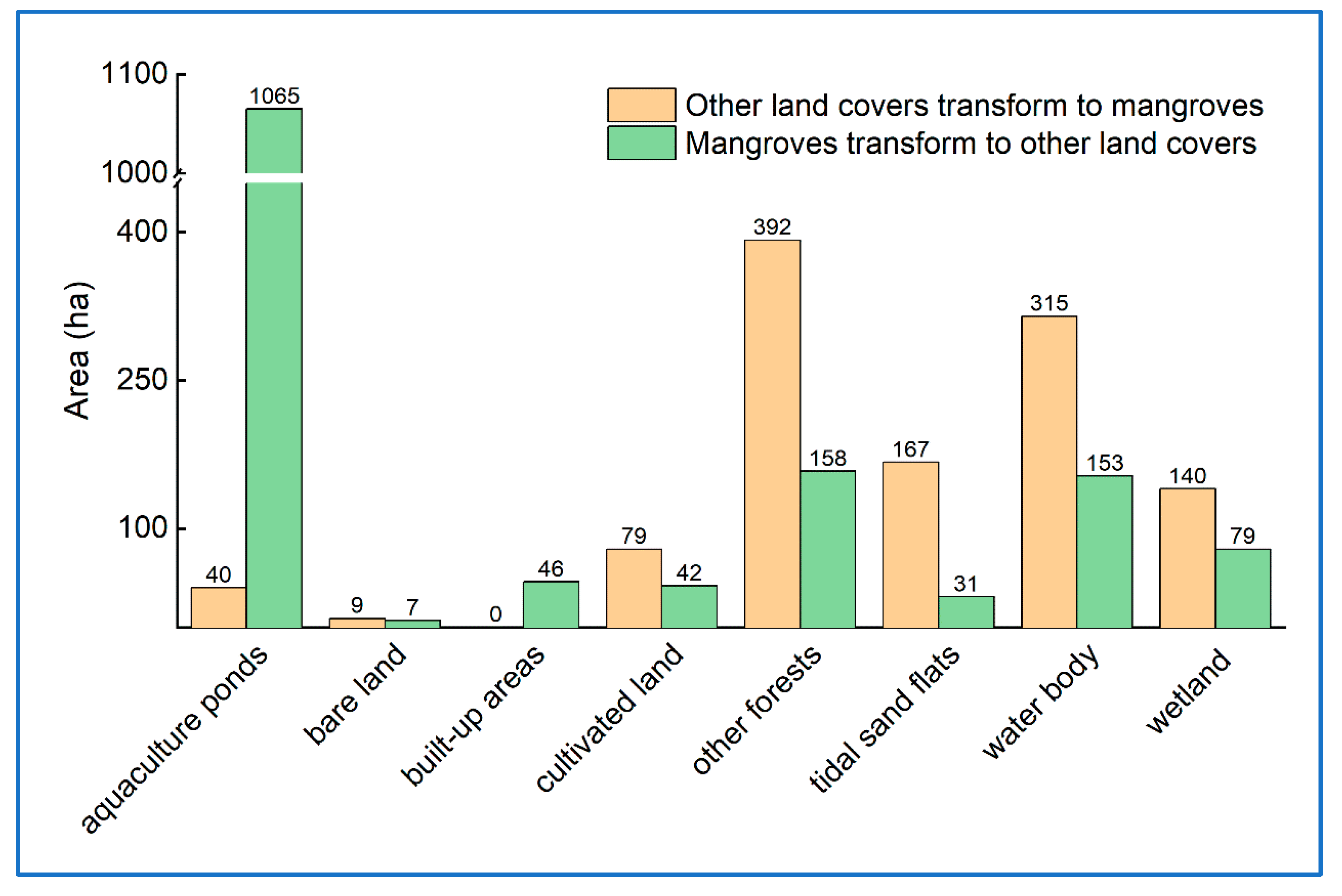
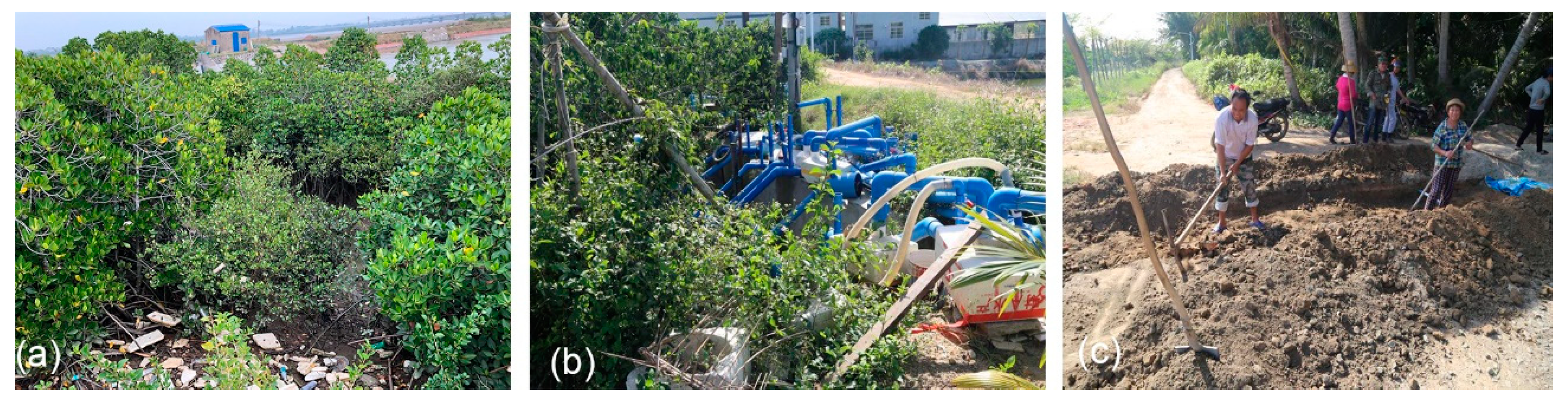
4.3. Pressures and Responses to Mangrove Changes on Selected Protected Areas of Hainan Island

Natural and anthropogenic pressures (Figure 3 and Section 2.2) have caused changes of mangrove forests on the seven protected areas of Hainan Island mapped in this study. Triangulation of the dynamic mapping of mangrove trends over 30 years with peer-reviewed literature and grey reports using the PSR logical framework (Section 2.2) shows that main human activities are the main pressures effecting the state of the mangrove ecosystems on the selected protected areas of Hainan Island. The most significant anthropogenic process contributing to the loss of mangrove forests has been reclamation for aquaculture. Since 1992, a market-led economic policy of aquaculture development in coastal areas has been implemented, and such economic development has led to undesirables impacts on the health and areal coverage of mangroves and wetlands of protected areas of Hainan Island [64]. Figure 8 is an extract of a time series of Landsat imagery that shows the progressive clearing of mangrove forest for development of aquaculture. Such landscape transformations have been common between 1987 and 2017 in areas such Qinglangang, Xinyingang, and Huachangwan. Moreover, land use conversion has also affected the health of non-cleared mangrove areas through pollution associated with wastewater disposal and discharge, and garbage disposal (Figure 9).
The national and local government has strengthened the mangrove wetland protection and established the nature reserves of mangrove forests, and implemented the policy of returning the aquaculture ponds to mangrove wetlands; impacts of these responses are evident areas such as the Dongzhaigang reserve, where our research has mapped an increase in areal coverage of mangrove forest between 2003 and 2013. The effectiveness of policy instruments (such as declaring a reserve) varies. For examples Dongzhaigang site was declared a nature reserve in 1980 (see Table 1), and listed as Wetlands of International Importance. Actions from the local and national government (illustrated in Section 4.2) have focused heavily in the protection and management of the reserve, with a resulting positive trend of mangrove growth between 1987 and 2013. On the other hand, the same policy instrument (i.e., declaring the site as a reserve) appears not as effective in Qinglangang. Despite being a protected area since 1981, the mangrove area decreased from 1986 to 2007 due to development of aquaculture in the reserve, demonstrating the significant of enforcement of policy instruments, to ensure sustainable management. Since 2009, new strategies are in place to promote Hainan Island as an international touristic destination [65], and this has added significant pressures the conservations and sustainable management of the mangrove forest of Hainan. The over-developed tourism has increased environmental pressures of mangrove wetlands, and area of mangrove forest have decreased from 2013 to 2017 in some reserves, such as Dongzhaigang and Huachangwan reserves.

4.4. Options for Sustainable Mangroves Management on Hainan Island

Integrated, participatory land use planning and policy are key elements of successful protection and management of mangrove forests in Hainan Island. Moreover, government actions to improve the functioning of existing nature reserves through strengthening effectiveness in the management, improving monitoring and law enforcement can also advance the sustainable management of this ecosystem.
This study shows how multitemporal, remote-sensing-based monitoring of mangrove forest trends can add evidence of the impacts of human activities on this ecosystem. Likewise, linking our results with a PSR logical framework, confirm that the responses to governmental policies and public awareness have a great impact on the dynamics of change of this ecosystem. Pledges of the national government to protect the mangroves at Dongzhaigang reserve appears to have improved the state of the mangrove ecosystem. On the other hand, the Qinglangang mangrove areas lack this strong link with the national government since the declaration of the reserve only occurs at the local level, and Table 2 as well as Figure 6 evidence a dominant negative trend of mangrove growth in this reserve. Public awareness and support by the national government to the local communities appear important for strengthening the management of coastal resources.

5. Conclusions

Mangrove forests fulfil many important ecological and socio-economic functions. However, increased population pressure in coastal areas and a general lack of awareness of the range of ecosystem services that mangroves provide to local populations have led to changes in the cover and condition of mangrove forests in nature reserves of Hainan Island over time.
This study shows that time series of remote sensing images have potential for mapping trends and dynamics of mangrove forests, and to identify different pressures that drive changes in the state of this ecosystem. Landsat TM/OLI images obtained over a 30-year time span enabled accurate mapping of total area of mangrove forests from 1987 to 2017, at an interval of six-year. Trend analysis showed a net decrease of 9.3% of mangrove area between 1987 and 2017.
A PSR conceptual framework was coupled with the multitemporal, remote sensing-based mapping to explore the drivers of mangrove changes and showed the main pressure driving mangrove changes are anthropogenic (e.g., reclamation for aquaculture, wastewater disposal and discharge, tourism development etc.). These activities impact the state of mangroves (health and extent), as demonstrated by the statistics derived from satellite-based cartography of mangroves. Time series remote sensing data also enabled exploring the association between policy responses adopted in the area (by local and national government) and changes in mangrove state (e.g., increase in area). Our findings evidence the potential of satellite-based remote sensing technologies in support of the implementation of the 2030 Agenda for Sustainable Development through providing information for enhancing protection, conservation, and sustainable management coastal mangrove forests.

Supplementary Materials

The following are available online at https://www.mdpi.com/2071-1050/11/19/5356/s1, Figure S1: Coverage of Landsat images for the study area on Hainan Island, Table S1: The Details of Landsat images and tidal height used in this study.

Author Contributions

J.L. conceived and designed the experiments, and analyzed the data; J.Z. performed the experiments and analyzed the data; L.Z. participated in the field surveys and data collection; J.L. and G.M. wrote the paper with contribution from all other authors.

Funding

This research was funded by the Strategic Priority Research Program of the Chinese Academy of Sciences (Grant No. XDA19030302) and the Finance Science and Technology Project of Hainan Province (Grant No. ZDKJ2016021).

Acknowledgments

This work was funded by the Strategic Priority Research Program of the Chinese Academy of Sciences (Grant No. XDA19030302) and the Finance Science and Technology Project of Hainan Province (Grant No. ZDKJ2016021). The authors are grateful to the colleagues who participated in the field surveys and data collection, and would like to express thanks to the anonymous reviewers for their voluntary work and the constructive comments to improve this manuscript.

Conflicts of Interest

The authors declare no conflict of interest.

References

  1. Giri, C.; Ochieng, E.; Tieszen, L.L.; Zhu, Z.; Singh, A.; Loveland, T.; Masek, J.; Duke, N. Status and distribution of mangrove forests of the world using earth observation satellite data. Glob. Ecol. Biogeogr. 2011, 20, 154–159. [Google Scholar] [CrossRef]
  2. Lugo, A.E.; Snedaker, S.C. The Ecology of Mangroves. Annu. Rev. Ecol. Syst. 1974, 5, 39–64. [Google Scholar] [CrossRef]
  3. Lin, P. Mangrove Ecosystem in China; Science Press: Beijing China, 1997. (In Chinese) [Google Scholar]
  4. Zhang, Q.M.; Zhang, Y.C. Study on Biogeomorphologic Process of Mangrove Coasts in South China. Quat. Sci. 1997, 17, 344–353. (In Chinese) [Google Scholar]
  5. Lin, P. A Review on the Mangrove Research in China. J. Xiamen Univ. (Nat. Sci.) 2001, 2, 592–603. (In Chinese) [Google Scholar]
  6. Glaser, M. Interrelations between mangrove ecosystem, local economy and social sustainability in Caeté Estuary, North Brazil. Wetl. Ecol. Manag. 2003, 11, 265–272. [Google Scholar] [CrossRef]
  7. Mumby, P.J. Connectivity of reef fish between mangroves and coral reefs: Algorithms for the design of marine reserves at seascape scales. Biol. Conserv. 2006, 128, 215–222. [Google Scholar] [CrossRef]
  8. Giri, C. Observation and Monitoring of Mangrove Forests Using Remote Sensing: Opportunities and Challenges. Remote Sens. 2016, 8, 783. [Google Scholar] [CrossRef]
  9. Alongi, D.M. Mangrove forests: Resilience, protection from tsunamis, and responses to global climate change. Estuar. Coast. Shelf Sci. 2008, 76, 1–13. [Google Scholar] [CrossRef]
  10. Donato, D.C.; Kauffman, J.B.; Murdiyarso, D.; Kurnianto, S.; Stidham, M.; Kanninen, M. Mangroves among the most carbon-rich forests in the tropics. Nat. Geosci. 2011, 4, 293–297. [Google Scholar] [CrossRef]
  11. Blasco, F.; Aizpuru, M.; Gers, C. Depletion of the mangroves of Continental Asia. Wetl. Ecol. Manag. 2001, 9, 255–266. [Google Scholar] [CrossRef]
  12. Metternicht, G.; Lucas, R.; Bunting, P.; Held, A.; Lymburner, L.; Ticehurst, C. Addressing mangrove protection in Australia: The contribution of Earth observation technologies. In Proceedings of the IGARSS 2018, Valence, Spain, 22–27 July 2018; pp. 6548–6551. [Google Scholar]
  13. Pastor-Guzman, J.; Dash, J.; Atkinson, P.M. Remote sensing of mangrove forest phenology and its environmental drivers. Remote Sens. Environ. 2018, 205, 71–84. [Google Scholar] [CrossRef] [Green Version]
  14. Oostdijk, M.; Santos, M.J.; Whigham, D.; Verhoeven, J.; Silvestri, S. Assessing rehabilitation of managed mangrove ecosystems using high resolution remote sensing. Estuar. Coast. Shelf Sci. 2018, 211, 238–247. [Google Scholar] [CrossRef]
  15. Zhang, K.; Thapa, B.; Ross, M.; Gann, D. Remote sensing of seasonal changes and disturbances in mangrove forest: A case study from South Florida. Ecosphere 2016, 7, e01366. [Google Scholar] [CrossRef]
  16. Everitt, J.H.; Yang, C.; Sriharan, S.; Judd, F.W. Using high resolution satellite imagery to map black mangrove on the Texas Gulf Coast. J. Coast. Res. 2008, 24, 1582–1586. [Google Scholar] [CrossRef]
  17. Giri, C.; Pengra, B.; Zhu, Z.; Singh, A.; Tieszen, L.L. Monitoring Mangrove forest dynamics of the Sundarbans in Bangladesh and India using multi-temporal satellite data from 1973 to 2000 satellite data from 1973 to 2000. Estuar. Coast. Shelf Sci. 2007, 73, 91–100. [Google Scholar] [CrossRef]
  18. Kuenzer, C.; Bluemel, A.; Gebhardt, S.; Quoc, T.V.; Dech, S. Remote sensing of mangrove ecosystems: A review. Remote Sens. 2011, 3, 878–928. [Google Scholar] [CrossRef]
  19. Green, E.P.; Mumby, P.J.; Edwards, A.J.; Clark, C.D.; Ellis, A.C. The assessment of mangrove areas using high resolution multispectral airborne imagery. J. Coast. Res. 1998, 14, 433–443. [Google Scholar]
  20. Kasischke, E.S.; Melack, J.M.; Dobson, M.C. The Use of Imaging Radars for Ecological Applications—A Review. Remote Sens. Environ. 1997, 59, 141–156. [Google Scholar] [CrossRef]
  21. Valiela, I.; Bowen, J.L.; York, J.K. Mangrove forests: One of the world’s threatened major tropical environments. Bioscience 2001, 51, 807–815. [Google Scholar] [CrossRef]
  22. FAO. The World’s Mangroves 1980–2005; FAO Forestry Paper 153; FAO: Rome, Italy, 2007; Available online: Ftp://ftp.fao.org/docrep/fao/010/a1427e/a1427e00.pdf (accessed on 30 October 2009).
  23. Spalding, M.; Kainuma, M.; Collins, L. World atlas of mangroves. In World Atlas of Mangroves; Routledge: London, UK, 2010. [Google Scholar]
  24. Hamilton, S.E.; Casey, D. Creation of a high spatio-temporal resolution global database of continuous mangrove forest cover for the 21st century (CGMFC-21). Glob. Ecol. Biogeogr. 2016, 25, 729–738. [Google Scholar] [CrossRef]
  25. Chen, L.; Wang, W.; Zhang, Y.; Lin, G. Recent progresses in mangrove conservation, restoration and research in China. J. Plant Ecol. 2009, 2, 45–54. [Google Scholar] [CrossRef]
  26. Jia, M.; Wang, Z.; Li, L.; Song, K.; Ren, C.; Liu, B.; Mao, D. Mapping China’s mangroves based on an object-oriented classification of Landsat imagery. Wetlands 2014, 34, 277–283. [Google Scholar] [CrossRef]
  27. Lee, T.; Yeh, H. Applying remote sensing techniques to monitor shifting wetland vegetation: A case study of Danshui River estuary mangrove communities, Taiwan. Ecol. Eng. 2009, 35, 487–496. [Google Scholar] [CrossRef]
  28. Li, M.S.; Mao, L.J.; Shen, W.J.; Liu, S.Q.; Wei, A.S. Change and fragmentation trends of Zhejiang mangrove forests in Southern China using multi-temporal Landsat imagery (1977–2010). Estuar. Coast. Shelf Sci. 2013, 130, 111–120. [Google Scholar] [CrossRef]
  29. Li, C.; Dai, H. Extraction of mangroves spatial distribution using remotely sensed data. Wetl. Sci. 2014, 12, 580–589. (In Chinese) [Google Scholar]
  30. Wu, P.; Ma, Y.; Li, X.; Yu, G. Remote sensing monitoring of the mangrove forests resources of Guangdong Province. J. Mar. Sci. 2011, 29, 16–24. (In Chinese) [Google Scholar]
  31. Zhang, W.; Chen, Z.; Wang, J. Monitoring the area variation of mangrove in Beibu Gulf Coast of Guangxi China with remote sensing data. J. Guangxi Univ. (Nat. Sci. Ed.) 2015, 40, 1570–1576. (In Chinese) [Google Scholar]
  32. Wang, T.; Zhang, H.; Lin, H.; Fang, C. Textural-spectral feature-based species classification of mangroves in Mai Po nature reserve from worldview-3 imagery. Remote Sens. 2016, 8, 24. [Google Scholar] [CrossRef]
  33. Wu, P.; Zhang, J.; Ma, Y.; Li, X. Remote sensing monitoring and analysis of the changes of mangrove resource in China in the past 20 years. Adv. Mar. Sci. 2013, 31, 406–414. (In Chinese) [Google Scholar]
  34. Chen, B.; Xiao, X.; Li, X.; Pan, L.; Doughty, R.; Ma, J.; Dong, J.; Qin, Y.; Zhao, B.; Wu, Z.; et al. A mangrove forest map of China in 2015: Analysis of time series Landsat 7/8 and Sentinel-1A imagery in Google Earth Engine cloud computing platform. ISPRS J. Photogramm. Remote Sens. 2017, 131, 104–120. [Google Scholar] [CrossRef]
  35. Wang, W.; Wang, M. The mangroves of China; Science Press: Beijing, China, 2007. (In Chinese) [Google Scholar]
  36. Tu, Z.; Chen, X.; Wu, R. Status of mangrove resources in mangrove nature reserves of Hainan Province. Dev. Manag. Mar. 2015, 32, 90–92. (In Chinese) [Google Scholar]
  37. Wu, R.; Chen, X.; Tu, Z.; Wang, D. Current status of mangrove community in Caiqiao of Hainan Province. Trop. Agric. Eng. 2017, 41, 82–84. (In Chinese) [Google Scholar]
  38. Wu, R.; Chen, X.; Chen, D.; Tu, Z.; Zhang, G.; Wang, D. Investigation on current status of mangrove resources in Xinying Bay of Hainan Province. Chin. J. Trop. Agric. 2016, 36, 35–37. (In Chinese) [Google Scholar]
  39. Working Group of Dongzhaigang National Nature Reserve management bureau. Hainan Dongzhaigang National Nature Reserve Master Plan (2011~2020); Working Group of Dongzhaigang National Nature Reserve management bureau: Haikou, China, 2011. (In Chinese) [Google Scholar]
  40. Working Group of Dongzhaigang National Nature Reserve management bureau. Hainan Qinglangang National Nature Reserve Master Plan (2016~2020); Working Group of Dongzhaigang National Nature Reserve management bureau: Haikou, China, 2015. (In Chinese) [Google Scholar]
  41. USGS. Earth Resources Observation and Science Center. Available online: http://glovis.usgs.gov (accessed on 18 September 2015).
  42. Lovelock, C.E.; Cahoon, D.R.; Friess, D.A.; Guntenspergen, G.R.; Krauss, K.W.; Reef, R.; Rogers, K.; Saunders, M.L.; Sidik, F.; Swales, A.; et al. The vulnerability of Indo-Pacific mangrove forests to sea-level rise. Nature 2015, 526, 559–563. [Google Scholar] [CrossRef] [PubMed] [Green Version]
  43. Duke, N.C.; Kovacs, J.M.; Griffith, A.; Preece, L.; Hill, D.J.; van Oosterzee, P.; Mackenzie, J.; Morning, H.S.; Burrows, D. Large-scale dieback of mangroves in Australia’s Gulf of Carpentaria: A severe ecosystem response, coincidental with an unusually extreme weather event. Mar. Freshw. Res. 2017, 68, 1816–1829. [Google Scholar] [CrossRef]
  44. Ball, M.C. Ecophysiology of mangroves. Trees 1988, 2, 129–142. [Google Scholar] [CrossRef]
  45. UNDP-GEF. Strengthening the Management Effectiveness of the Wetland Protected Area System in Hainan for Conservation of Globally Significant Biodiversity. Project Document. 234 pages. 2013. Available online: https://info.undp.org/docs/pdc/Documents/CHN/Hainan%20Prodoc%20signed-82277.pdf (accessed on 27 June 2019).
  46. Roy, D.P.; Wulder, M.A.; Loveland, T.R.; Woodcock, C.E.; Allen, R.G.; Anderson, M.C.; Helder, D.; Irons, J.R.; Johnson, D.M.; Kennedy, R. Landsat-8: Science and product vision for terrestrial global change research. Remote Sens. Environ. 2014, 145, 154–172. [Google Scholar] [CrossRef] [Green Version]
  47. Andrew, A.M. An Introduction to Support Vector Machines and other kernel-based learning methods. Kybernetes 2001, 32, 1–28. [Google Scholar]
  48. Yao, Y.J.; Zhang, Z.X.; Qin, Q.M.; Qiu, Y.F. Study on wetland information extraction of remote sensing images based on support vector machine. Appl. Res. Comput. 2008, 25, 989–990. (In Chinese) [Google Scholar]
  49. Wang, Z.W.; Sun, J.J.; Yu, Z.Y.; Bu, Y.Y. Review of remote sensing image classification based on support vector machine. Comput. Sci. 2016, 43, 11–17. (In Chinese) [Google Scholar]
  50. Zhang, C.; Zang, S.Y.; Jin, Z.; Zhang, Y.H. Remote sensing classification for Zhalong wetlands based on support vector machine. Wetl. Sci. 2011, 9, 263–269. (In Chinese) [Google Scholar]
  51. Lesiv, M.; See, L.; Juan Laso Bayas, J.; Sturn, T.; Schepaschenko, D.; Karner, M.; Moorthy, I.; McCallum, I.; Fritz, S. Characterizing the spatial and temporal availability of very high resolution satellite imagery in google earth and microsoft bing maps as a source of reference data. Land 2018, 7, 118. [Google Scholar] [CrossRef]
  52. Bey, A.; Sánchez-Paus Díaz, A.; Maniatis, D.; Marchi, G.; Mollicone, D.; Ricci, S.; Bastin, J.F.; Moore, R.; Federici, S.; Rezende, M.; et al. Collect earth: Land use and land cover assessment through augmented visual interpretation. Remote Sens. 2016, 8, 807. [Google Scholar] [CrossRef]
  53. Buja, K.; Menza, C. Sampling design tool for ArcGIS: Instruction manual. [for ESRI ArcGIS 10.0 Service Pack 3 or higher]. Available online: https://coastalscience.noaa.gov/project/sampling-design-tool-arcgis/ (accessed on 30 October 2015).
  54. Zhang, H. Remote Sensing Monitoring and Driven Force Analysis of Mangroves Change in Hainan Island during Nearly 30 Years. Master’s Thesis, Institute of Remote Sensing and Digital Earth, Chinese Academy of Sciences, Beijing, China, 2015. (In Chinese). [Google Scholar]
  55. Sun, Y.; Liao, B.; Guan, W.; Wang, R.; Ding, D.; Zhong, C. Spatial patterns and environmental factors of rapidly degraded mangroves at Dongzhaigang Harbor in Hainan. J. South China Agric. Univ. 2015, 36, 111–118. (In Chinese) [Google Scholar]
  56. Wang, J.; Wang, P.; Fu, X.; Zhao, Z.; Qiu, P.; Ji, Y.; Wu, D. Distribution and enrichment of heavy metals in mangrove wetland sediments and plants from Dongzhai harbor. Southwest China J. Agric. Sci. 2018, 31, 611–618. (In Chinese) [Google Scholar]
  57. Wang, L.; Li, Z.; Pu, Y.; Liao, W.; Zhang, Q.; Yu, K.; Zhao, H. Health evaluation of mangrove community in Dongzhaigang, Sanyahe, and Qingmeigang Mangrove Nature Reserves of Hainan Province. J. Trop. Oceanogr. 2011, 30, 81–86. (In Chinese) [Google Scholar]
  58. Fan, H. Protecting and developing mangrove forests in China—Enlightenment from tsunami and Typhoon. South. Land Resour. 2005, 10, 18–20. (In Chinese) [Google Scholar]
  59. Xu, D.; Liao, B.; Zhu, N.; Guan, W.; Li, S.; Zhong, C. A primary analysis on mangrove degradation in Dongzhaigang of Hainan Island. Ecol. Sci. 2014, 33, 294–300. (In Chinese) [Google Scholar]
  60. Hu, Z.; Xu, Y. Field Survey and Analysis of the Impact of Typhoon Activity on the Mangroves in Bamenwan in 2014; Fujian Quality Management: Fuzhou, China, 2017; p. 15. (In Chinese) [Google Scholar]
  61. Qiu, M.; Wang, R.; Ding, D.; Mao, J.; Liao, B. Impact of “Rammasun” on mangrove communities in Dongzhaigang, Hainan. Ecol. Sci. 2016, 35, 118–122. (In Chinese) [Google Scholar]
  62. Ren, J.; Weng, C.; Zhang, L. Impact of “Rammasun” on the garden trees in Hainan cities. Xiandai Hortic. 2015, 8, 99–101. (In Chinese) [Google Scholar]
  63. Ma, W.; Wang, M.; Wang, W.; Liu, Y.; Luo, L.; Tang, C. Biodiversity of mangrove mollusks in the west coast of Hainan Island, China. Biodivers. Sci. 2018, 26, 707–716. (In Chinese) [Google Scholar] [CrossRef]
  64. Liu, Y.; Song, C. Aquaculture development in coastal areas of Hainan Province. Ocean Dev. Manag. 2014, 5, 90–93. (In Chinese) [Google Scholar]
  65. The Policy of the Chinese Government. Suggestions on Promoting the Construction and Development of Hainan International Tourism Island; Issued by the State Council [2009] No.44 Documentary. Available online: https://baike.baidu.com/item/ (accessed on 30 July 2019). (In Chinese).
Figure 1. Location of selected protected areas of Hainan Island. (Red lines are the boundaries of selected reserves; Green areas indicates the extent of mangrove forests in 2017).
Sustainability 11 05356 g001
Figure 2. Location of field survey points and photographs of some land cover types: (a) mangrove forest in Xinyinggang; (b) young seedlings in the cultivation of mangrove forests; (c) fishpond; (d) salt pan; (e) paddy field and salt marsh.
Sustainability 11 05356 g002
Figure 3. A conceptual framework of pressure-state response for mangrove forests on selected protected areas of Hainan Island.
Sustainability 11 05356 g003
Figure 4. Area change of mangroves on selected protected areas of Hainan Island between 1987 and 2017.
Sustainability 11 05356 g004
Figure 5. The changes in mangrove area at selected sites on Hainan Island derived from Landsat images from 1987 to 2017.
Sustainability 11 05356 g005
Figure 6. Conversion between mangroves and other land cover types in Hainan protected areas from 1987 to 2017.
Sustainability 11 05356 g006
Figure 7. The annual change in mangrove area on selected protected areas of Hainan Island over 30 years.
Sustainability 11 05356 g007
Figure 8. The changes of mangrove wetlands on Landsat images from 1987 to 2017.
Sustainability 11 05356 g008
Figure 9. The photographs of pollution and loss of mangrove wetlands on Hainan Island. (a) Garbage disposal; (b) Wastewater disposal; (c) Digging aquaculture ponds.
Sustainability 11 05356 g009
Table 1. The details of the selected reserves in this study.
SiteDeclared YearDeclared Area (ha)JurisdictionNumber of Mangrove Species *
Dongzhaigang19803337International/National25
Qinglangang19812948Provincial35
Xinyinggang1986350Local12
Maniaogang1992696LocalND **
Huachangwan1995150Local12
Xinyingwan1992115Local16
Dongfang20061429ProvincialND
* Mangrove species includes true- and semi-mangrove species; ** ND indicates unknown number of mangrove species due to no survey data in the reserve.
Table 2. Accuracy assessment for the classification results from the 2017 Landsat images.
OA (%)KappaMangroveNon-Mangrove
PA (%)UA (%)PA (%)UA (%)
98.80.9898.399.099.198.6
Table 3. Status of the mangrove area (ha) on selected protected areas of Hainan Island from 1987 to 2017 using Landsat images.
Site1987199319982003200720132017
Dongzhaigang1466 1532 1612 1666 1729 1788 1733
Qinglangang1656 1447 1328 1165 1150 1214 1174
Xinyinggang415 330 305 294 263 276 291
Maniaogang66 56 34 46 51 96 96
Huachangwan454 397 341 257 219 322 300
Xinyingwan623 760 723 483 478 577 607
Dongfang36 25 38 30 60 67 77
Total4716 4547 4381 3940 3950 4340 4278
Table 4. The area of mangrove forests (ha) on selected protected areas of Hainan Island from different map data sources.
Site (Years of Mapping in Brackets)MFDC (2015)WMF (2000)WAM10 (2000)Jia (2013)Zhang (2013)Wu (2010)
Dongzhaigang158616291799197516732007
Qinglangang9349831108 5451627
Xinyinggang338120313
Xinyingwan411163370
Huachangwan21213244 212
Dongfang43941
Maliaogang701125
Total355530773700197522183846
Total of this study (years of mapping in brackets)4278 (2017) 3940 (2003)3940 (2003)4340 (2013)4340 (2013)3950 (2007)
Average *391735093820315837293898
Used data sourcesLandsat &Sentinel-1ALandsatLandsatLandsatLandsatLandsat &HJ-1
MFDC: Mangrove forest map of China in 2015, from Chen et al [34]; WMF: Mangrove forest map of the world, from Giri et al [1]; WAM10: World Atlas of Mangroves from Spalding et al. [23]; Jia: Northeast Institute of Geography and Agroecology, Chinese Academy of Sciences, from Jia [26]; Zhang: Institute of Remote Sensing and Digital Earth, Chinese Academy of Sciences, from Zhang [54]; Wu: First Institute of Oceanography, State Oceanic Administration, From Wu et al [33]; Sentinel-1A: C-band synthetic aperture radar data from European Space Agency; HJ-1: the Chinese Huanjing-1 (HJ-1) CCD data. * Make the average between the values of other researchers and the values of this study.

