Article

Assessing Effectiveness of PPGIS on Protected Areas by Governance Quality: A Case Study of Community-Based Monitoring in Wu-Wei-Kang Wildlife Refuge, Taiwan

1
Department of Geography, National Taiwan University, Taipei 10617, Taiwan
2
School of Forestry and Resource Conservation, National Taiwan University, Taipei 10617, Taiwan
3
Graduate Institute of National Development, National Taiwan University, Taipei 10617, Taiwan
*
Author to whom correspondence should be addressed.
Sustainability 2019, 11(15), 4154; https://doi.org/10.3390/su11154154
Submission received: 23 June 2019 / Revised: 25 July 2019 / Accepted: 29 July 2019 / Published: 1 August 2019

Abstract

:
Based on the criterion of governance quality, this study aimed to use the case of community-based monitoring in Taiwanese Wu-Wei-Kang Wildlife Refuge to evaluate the impact of public participation geographic information system (PPGIS) on its governance quality regarding inclusiveness, respect, competence, visions and scopes, accountability, and equity. Our research included 31 informants and 75 records (25 by in-depth interview and 50 from participant observation) collected in the field from 2009 to 2015. The results show that there are several effects attributable to the application of PPGIS in substratum elevation monitoring, including generating high quality data; strengthening monitoring processes and extending attributes of its outputs by lay knowledge; promoting stakeholders’ understanding of wetlands and their involvement in negotiations; increasing their capacity and degree to participate in refuge management; amending visions and scopes of this refuge; rearranging stakeholder divisions of labor; and assisting local communities as partners of this refuge. This study demonstrates that governance quality could provide a useful concept for evaluating PPGIS effectiveness on stakeholders’ participation, knowledge interpretation, capacity and consensus building, decision-making, and distribution of rights. Being a sole case with a qualitative approach, further case studies need to be undertaken to better understand the relationships between protected area governance quality and PPGIS.

1. Introduction

The present study seeks to examine institutional arrangements and distribution of rights and duties, etc. for governance of protected areas (PA) [1,2,3]. Due to increases in conflicts with stakeholders, mainly from local communities, and increases in the number and area of PA, a paradigm shift in the management of PA has been noted in recent years. The traditional paradigm of PA management, characterized by dominance of natural scientists and government agents, has been replaced by a PA management paradigm that includes a sociopolitical process of stakeholder consultation and wise exercise of judgment [4]. Under this new paradigm, the international conservation community now tends to regard the participation of stakeholders as the proper basis for the governance of PA [5,6]. Since members of local communities rank among the main stakeholders of PA, their views and standpoints regarding the utilization, distribution, monitoring, and social norms with respect to natural resources are considered important references for the management of PA [7,8]. At the same time, the governance of PA is a highly complex affair, involving a variety of objective factors (e.g., land use, funding, management organizations, and local rights) and is usually faced with competition among different management strategies [9]. Therefore, questions concerning the form that participation by local communities should take and how the output of such participation can improve the management effectiveness and governance quality of PA have become popular research topics for the international conservation community [10].
Because the management of PA involves a variety of objective items (e.g., environmental sensitivity, biological habitat, administrative boundary, and land utilization), it could usefully adopt geospatial information technologies, such as geographic information system (GIS), which is widely applied in PA management at present [11,12]. However, since GIS offers completely quantitative geospatial information, some consider GIS to be an elitist and antidemocratic technology, based on high technology, and expensive to implement and operate [13]. Although GIS can streamline and accelerate decision-making processes, it may also marginalize local communities and individuals who lack access to it, leading to the brushing aside of their opinions as a consequence [12]. In this perspective, widescale application of GIS to natural resource management has been criticized for strengthening the dominance of elites and authorities and for aggravating the already unequal power relations among stakeholders [14,15,16].
While applications of a variety of participatory methods have become increasingly important in recent decades, such as community-based participatory research (CBPR), participatory action research, participatory rural appraisal, and participatory mapping [16,17,18], public participation geographic information system (PPGIS) has been applied in PA management [19,20,21] and is regarded as offering a participatory interface or tool that could incorporate social intentions [22,23,24]. As to advanced geospatial information technologies (GITs), PPGIS allows local stakeholders participation, knowledge interpretation, capacity, consensus building, and decision-making through the governance process [25,26,27,28]. By PPGIS, stakeholders can jointly produce geospatial information with local perspectives through public participation processes and can integrate such information with relevant scientific knowledge so as to adjust the procedure and quality of decision-making of PA [29,30] in ways that incorporate social considerations in PA governance [31,32,33].
Furthermore, the way the existing PA decision-making mechanism is influenced by PPGIS is also one of the main issues of the current PPGIS research community [11,29]. Some researches [34,35,36,37] argued that, while PPGIS might significantly contribute to PA governance, few concrete cases have been examined to empirically demonstrate the ways in which PPGIS positively affects the processes and quality of PA decision-making. Also, Brown et al. [38] argue that the information gathered by PPGIS can be only regarded as supplemental information, which contributes little to actual PA governance. Thus, there is a significant lack of agreement as to the impact of PPGIS on actual PA governance [30,32].
PPGIS defines a sort of socio-technical practice, and the value and limitations of the PPGIS need to be investigated in the complex and detailed social contexts of PPGIS applications [39]. In recent years, many studies have examined the application of PPGIS in PA governance. Related studies have discussed how GIS can address different facets of governance [34,36]. As for participation benefits, such studies have examined how PPGIS can empower stakeholders, integrate knowledge, and assist in negotiation-based decision-making [40,41,42]. However, these related studies scarcely discuss, based on practical experiences, how the PPGIS and related GIT applications affect the details of the decision-making procedure and quality. As yet, no systematic method has been found to be useful for evaluating the relative advantages and limitations of PPGIS in PA management [20,27,30]. Consequently, this study is aimed at evaluating the effectiveness of PPGIS for promoting the governance quality of PA by examining the case of the Wu-Wei-Kang Wildlife Refuge in Taiwan.

2. Theoretical Background

Given the continuous expansion of PA worldwide and the wide diversity of types and objectives of PA management [43,44,45], the need for assessments of the effectiveness of PA management has also increased [46,47]. To assess PA management effectiveness, various indices (e.g., personnel, facilities, finance, laws, regulations, and institutional framework) have been analyzed qualitatively or quantitatively. In order to promote management effectiveness in detail, these indices should be improved [2]. However, some studies argue that, besides management effectiveness of PA, such assessments should also focus on good governance as well to encourage balanced interactions between management organizations and surrounding communities, to improve accountability, and to equitably distribute conservation benefits [5,9,48].
Graham et al. [49] argue that PA governance assessment focuses on the structure and process of how to make decisions, to exercise power, and to divide responsibilities and that it involves a variety of factors (including laws and regulations, policies, cultural background, values, and human rights) [2,50]. Lockwood et al. [51] argue that good governance of PA provides the basis for attaining management benefits and thus should comply with some basic principles, including inclusiveness, integration, legitimacy, transparency, accountability, fairness, capability, and adaptability. Inclusiveness signifies the essential guiding value of governance; namely, good governance should include and integrate the benefits, knowledge, opinions, and actions of diverse stakeholders to address varied and complex situations and to promote effective utilization of natural resources. Legitimacy should be based on a transparent decision-making procedure and should allow downward, outward, and upward extension of accountability, thus augmenting the fairness of governance. Good governance should assist stakeholders in developing the capability, organization, and institution of management, thus improving adaptability to environmental uncertainty.
Lockwood [9] and Turner et al. [52] contend that governance quality is intended to check and promote the effectiveness of governance in the context of decision-making and execution. Governance quality focuses on processes that are aimed at the good governance of PA by facilitating improvements in the quality of decision-making and execution [6,53] and could be regarded concretely as a multitude of dynamic feedback mechanisms at all societal levels [54]. Borrini-Feyerabend et al. [10] point out that the notion of “governance quality” plays a key role in different governance types. Governance quality treats the PA as holistic systems and maintains the following principles: voice and legitimacy, direction, performance, accountability, fairness, and rights. First, governance quality should involve respect for the basic rights of local communities and include local voices in decision-making processes for PA, thus establishing the legitimacy of PA governance. Second, the management organizations of PA should stipulate definite, appropriate, and attainable visions and directions jointly with local communities through open participation and consultation. Meanwhile, information sharing and the decision-making process should be transparent to ensure consistency between management effectiveness and governance effectiveness. Besides, an accountability mechanism should be established between management organizations and stakeholders to improve governance performance. Finally, stakeholders should share the outcomes and benefits of PA based on the principle of fairness and respect for rights [6,10].
Governance quality focuses on improvements in decision-making procedures and institutional rearrangements, and its core element is the participation of stakeholders [55,56,57]. From a critical perspective, participation can be viewed as a means of returning the management authority of natural resources back to local communities, which improves the decision-making quality and promotes execution [58]. It is, therefore, of great importance to attract the effective participation of stakeholders from different sectors and to integrate their different knowledge systems to make decisions in a consultative manner, thus improving governance quality; this is an important prerequisite for improving the management effectiveness of PA and for ensuring equitable distribution of benefits and is also currently the core topic for governance quality [2,10,59].
As evaluating governance quality is the basis of assuring good governance [52], following from the literature and discussion above, this study defines the governance quality of PA in terms of the following aspects: inclusiveness, respect, competence, vision and scope, accountability, and equity.
  • Inclusiveness refers to the inclusion of those who are involved and empowered through the process and ownership of the product, including various types and degrees of participation [49,51].
  • Respect means respect for rights and entitlements, multiple views, and lay knowledge [10,36].
  • Competence concerns enhancing the local ability in management and responsiveness to local contexts [6,10,49].
  • Accountability refers to the transparency and accessibility of the decision-making process as well as the mechanisms used to determine and trace liability [9,36].
  • Regarding Equity, participants should consider differences in age, gender, and social status, voices, etc. It is also necessary to consider building and/or promoting the capacity of participants and concerned stakeholders. Moreover, a means or process for resolving or managing conflicts must be established [10,54].
  • Vision and scope: Given the close links between the governance effectiveness and management effectiveness of PA [9], governance quality also requires that the vision, objective, and scope of PA should be established jointly with the stakeholders.
Overall, the present study argues that the governance quality of PA should be based on the participation of stakeholders and respect for these participants; the vision and scope of PA governance must be established jointly with the stakeholders and associated with competence, accountability, and equity. In addition, it is necessary to develop a consultation mechanism to address the inevitable conflicts among stakeholders in order to ensure the sustainable operation of the entire governance mechanism. The present study intends to adopt the above framework of governance quality to evaluate the influence of PPGIS in PA governance.

3. Case Study

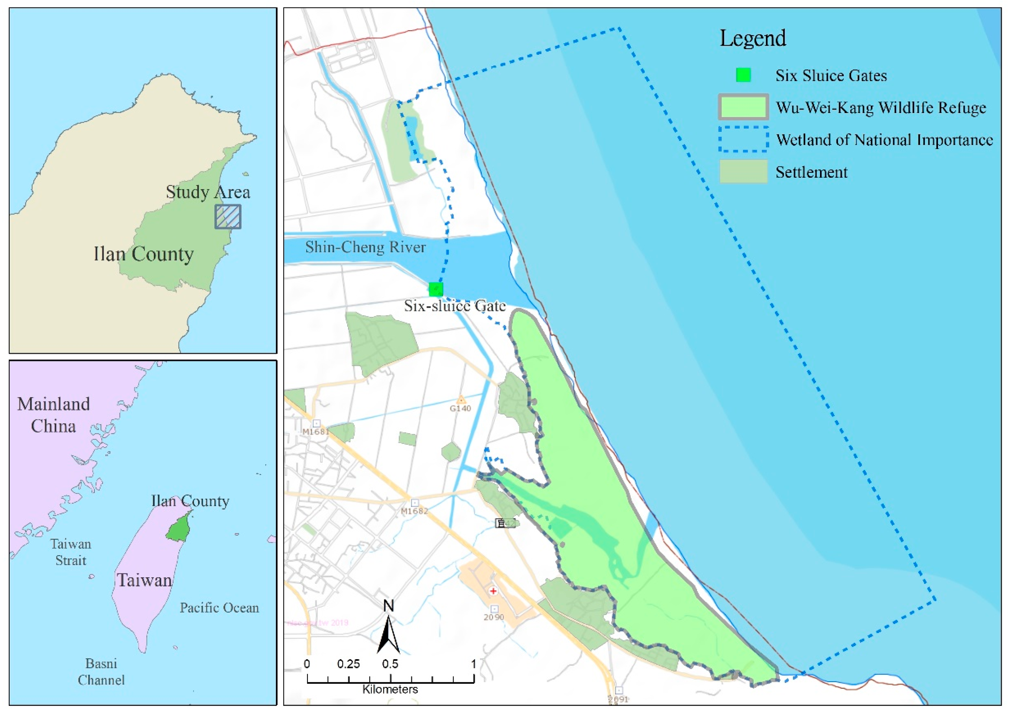
3.1. Background of Research Site

The present case study concerns the Wu-Wei-Kang Wildlife Refuge in Ilan County, northeastern Taiwan where we introduced PPGIS and worked with a local conservation organization, Wu-Wei River Cultural and Education Association (WRCEA), on refuge planning and management and community monitoring from 2007. Since the project requested the participation of local stakeholders multiple times and adopted their views in decision-making in refuge management, we found it suitable to take up the issue of governance quality. The Wu-Wei-Kang Wildlife Refuge was designated in 1993, and its area was expanded to 103.35 ha in 2015 [60,61,62]. It is a semi-enclosed wetland, identified as an important roosting site for migratory waterfowl in northeastern Taiwan. (See Figure 1 for more information about the refuge and neighboring areas.)
The management objective of this refuge is to protect the wetland ecosystem and biodiversity, to provide a favorable habitat for migratory birds, and to develop environmental education and sustainable tourism with active community participation, thereby ensuring the sustainable development of local communities [62,63,64,65]. When the Wetland Conservation Act came into effect in 2013, the Wu-Wei-Kang Wildlife Refuge was included and it was extended northward to the river mouth of the Shin-Cheng River and the coastal wetland as a wetland of national importance to cover a total area of 642 hectares [63].
Since 2007, sponsored by the Ilan County Government, WRCEA started to host platform meetings to communicate and discuss issues concerning the wildlife refuge. The participants in this platform meeting are primarily stakeholders who are relevant to the management of this refuge. They include 1. government agencies (Ilan County Government, Lou-Dong Forest District Office, etc.); 2. academic teams (National Ilan University, Biodiversity Research Center of Academia Sinica, and this research team); and 3. local community organizations/residents (community development associations by this refuge, village chiefs, WRECA, and other local residents). Meanwhile, some scholars and experts were also invited to the discussion according to the target requirements in operation and management [64,65]. In general, the topics discussed in the platform meeting are mainly those of refuge management including habitat restoration, community communication, infrastructure maintenance, research and survey, and environmental education. These platform meetings offered an opportunity for the stakeholders to learn to use PPGIS proficiently and for local communities to apply PPGIS-related knowledge and software to the decision-making process regarding the main governance issues [62]. It also covered annual planning for the following year. In addition, the participants are able to distribute missions and responsibilities and to divide labors of stakeholders for different operational and management issues at platform meetings [63] (Figure 2). Up to the present, platform meetings have been held once or several times per year and they have become important occasions to reveal situations, to discuss issues, and to make decisions on managing the refuge and wetland of national importance, as well as to provide occasions for interactions between different stakeholders.

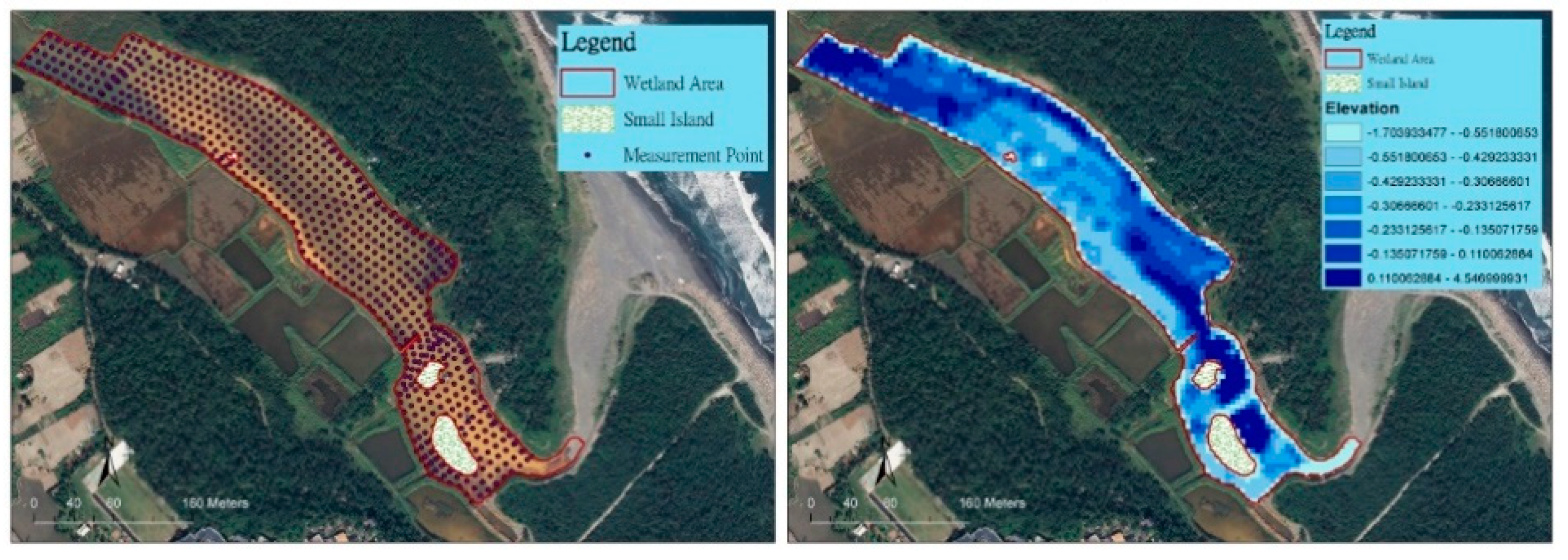
3.2. The Practice of Wetland Elevation Monitoring and PPGIS

WRCEA is comprised mainly of residents of local communities near this wildlife refuge and is a local conservation organization that is committed to reviving local culture and to promoting ecological conservation. Since its founding in 1997, WRCEA has convened volunteers to survey and monitor birds once every month in the birds’ migration season, from September to April. In cooperation with academic teams, WRCEA began to use PPGIS in 2008 to modify the method and routes of community-based bird monitoring and to discuss the monitoring results, for which geospatial information became an important reference for decision-making in platform meetings and management practice of this refuge and wetland of national importance [66,67,68,69].
In 2009, influenced by the construction of a new six-sluice gate for better drainage and flood control around open river areas of the Shincheng River and the gradual serious deposition and unprecedented hydrological variation in the wetland, WRCEA worked with the academic team to initiate a community-based substratum elevation monitoring project. This monitoring scheme was to investigate the aggradation status and rate of wetlands by measuring the substratum elevation for deciding the subsequent management strategy of the wildlife refuge.
It was decided to measure the substratum elevation at the key water areas of the refuge once per year to determine the trend of variation in the elevation of water bottom over time, considered a capacity of WRCEA. Based on lay knowledge, community residents (volunteers of WRCEA) helped the academic team select appropriate sites to install auxiliary measuring devices (e.g., water gauges and sectional piles), to simplify the operation procedure, and to determine the dates so as to avoid the peak tide water level.
The community-based substratum elevation monitoring project was launched for the first time during low tide on a weekend in October 2010. Approximately 20 people, including local volunteers and the academic team, were involved in the monitoring scheme implementation over time. In total, about 762 measuring points were set up and recorded every time. After the field measurements, the academic team took the data back to the university to create a model of wetland elevation by employing a spatial interpolation method (Figure 3). Then, a second PPGIS workshop was organized to share the data and its analysis with stakeholders. In the workshop, a 3-D virtual environment was arranged to demonstrate the monitoring results in order to initiate broad and deep discussion and interpretation and, more importantly, to decide on further actions to improve wetland conditions.
Moreover, aware of possible influences of the tide, it was decided to introduce tidal current investigation in the second workshop on the first wetland substratum elevation measurement so that the hydrological conditions in the protected wetland could be considered more holistically [65].
This was the first time that people could gather data on the elevation of the substratum and hydrological changes after the designation of the refuge [62]. Based on this achievement and with the help of the Luodong Forest District Office and the Ilan County Government, WRCEA applied for funding to support follow-up monitoring activities under the official Project of Taiwanese Wetlands of Importance. In total, WRCEA and the academic team conducted elevation monitoring four times and tidal current investigation thrice between 2011 and 2015, thus providing key data on environmental changes for the management of the refuge and wetland.
According to the results of community-based substratum elevation monitoring and tidal current investigation, the aggradation mechanism of the wetlands was ascertained, on the basis of which the authority and stakeholders were able to develop a follow-up management strategy for the wildlife refuge. The PPGIS served as an important communication platform or medium that allowed the community residents with their lay knowledge to assist in the design, amendment, and execution of the survey and measurement; to improve the contribution and value of the lay knowledge, and to strengthen the legitimacy of the participation of community residents in the decision-making for wildlife refuge management. Further, the monitoring results presented by PPGIS revealed the spatial distribution of elevation and silt, which promoted the participation and broadened and deepened the discussions of participants at the platform meetings. Also, based on materials and messages displayed by PPGIS of different spatial scales, the stakeholders were able to understand the potential relationship between substratum elevation, tidal currents, and other hydrological factors, which contributed to developing the follow-up tidal current investigation. These monitoring results by PPGIS were able to assist the stakeholders (participants) in amending the management objectives and scope of this refuge and in dividing responsibilities according to their respective levels of authority in the platform meeting. Finally, all related monitoring data and results of discussion and consultation were incorporated into the conservation plan, i.e., the official management plan of the wildlife refuge, thus becoming formal management items.
Furthermore, we seek to systematically describe how PPGIS assists community monitoring and helps stakeholders in performing better communication and decision-making in refuge operation and management. To achieve this, the effects of PPGIS on improving the processes of problem identification, monitoring method design, monitoring implementation, data analysis, and decision-making are represented by Figure 4 in this study. Among the different processes mentioned previously, PPGIS can help the stakeholders to better identify the changes in the wetland with 3-D environment visualization as well as to better design the monitoring method with lay knowledge. By contrast, the results collected from community monitoring can be used by PPGIS to help spatial interpolation, overlapping, and transparent layers. These functions allow the stakeholders to assess the results and information with greater flexibility. Meanwhile, the information extracted from the profile analysis assists in depicting the elevation profile at the bottom of the wetland. This profile allows the stakeholders to explore the causes of environmental change through simulation views and thereby to redetermine their management targets. Furthermore, we hope that the research framework presented in this study can facilitate further discussion on how the application of PPGIS can influence the participation and governance quality of the stakeholders associated with the PA.

3.3. Methods and Methodology

PPGIS was the main tool adopted in this case study to enable the academic team; WRCEA; and other stakeholders, such as local county government and forestry officers, to work together during the processes of monitoring, planning, implementation, and result data analysis. In order to understand how the introduction of PPGIS affects the relationship between stakeholders’ participation and refuge governance quality, we adopted a participatory approach in this study and collected field data using qualitative research methods that include participant observation and in-depth interviews. The locations chosen for participant observations in this study are primarily places where stakeholder discussions and debates on the management of Wu-Wei-Kang Wildlife Refuge occur. These include the platform meetings, wetland on-site inspections, wetland deposition meetings, Wildlife Refuge Management Effectiveness Evaluation workshops, the general meetings of members of WRCEA, monitoring results presentations, and review meetings of policies related to the PA. In addition, we also interviewed key informants after these activities to understand their views on these occasions. Furthermore, the interviews conducted in this study were primarily targeting the stakeholders who participated in the community monitoring and platform meetings. The interviewees (informants) include members of WRCEA, community residents, scholars and experts of the wildlife refuge, staff of Luodong Forest District Office, staff of Ilan County Government, and the academic team. The informants, based on their own experiences of participating in PPGIS (including monitoring planning and implementing, monitoring data interpreting, and the negotiation process), expressed their opinions towards the application of PPGIS in the refuge, their acceptance level for the operation of PPGIS, and their recommendations on the possible adjustment of the methods of operation.
Axial coding is used in this study to conduct coding and to analyze the data from participant observations and interviews according to the concept of governance quality. By cross-checking the results from different informants and/or by different methods, we can confirm the effectiveness of PPGIS in PA. During this study, the privacy of the informants was ensured by a policy of anonymity. From February 2009 to June 2015, 50 participant observations and 25 in-depth interviews were conducted, through which a total of 75 field records were collected (Appendix Table A1 and Table A2).
Based on the above information collected during fieldwork, this study identified the following themes around which to discuss the application of PPGIS to assess governance quality in the Wu-Wei-Kang Wildlife Refuge: 1. promote inclusiveness (for local stakeholders); 2. create respect (for lay knowledge); 3. enhance competence (the transparency of information distribution and decision-making); 4. define the management visions and scopes; 5. create accountability (shared rights and liabilities); and 6. develop equity (establishment of equitable partnerships) in terms of governance quality.

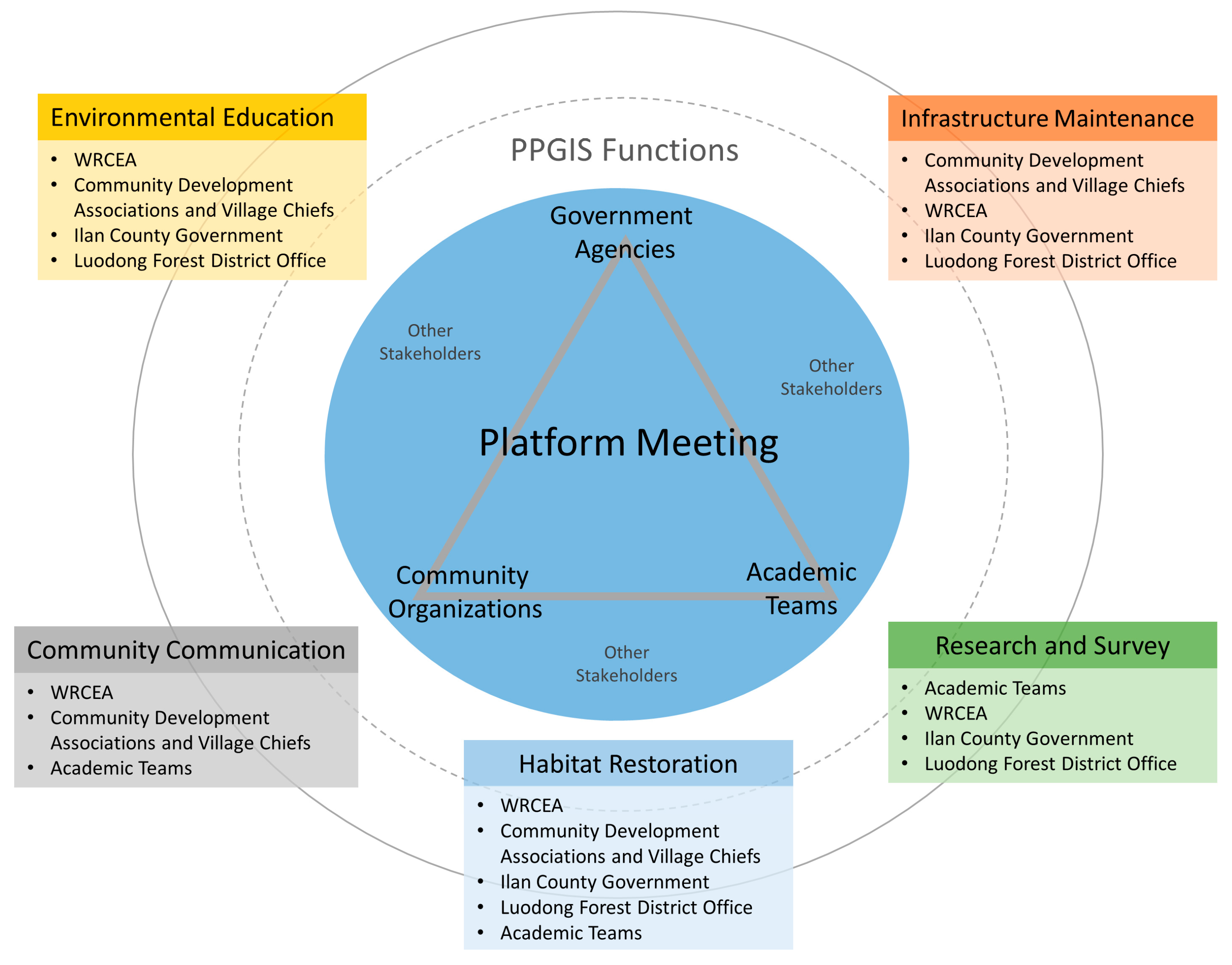
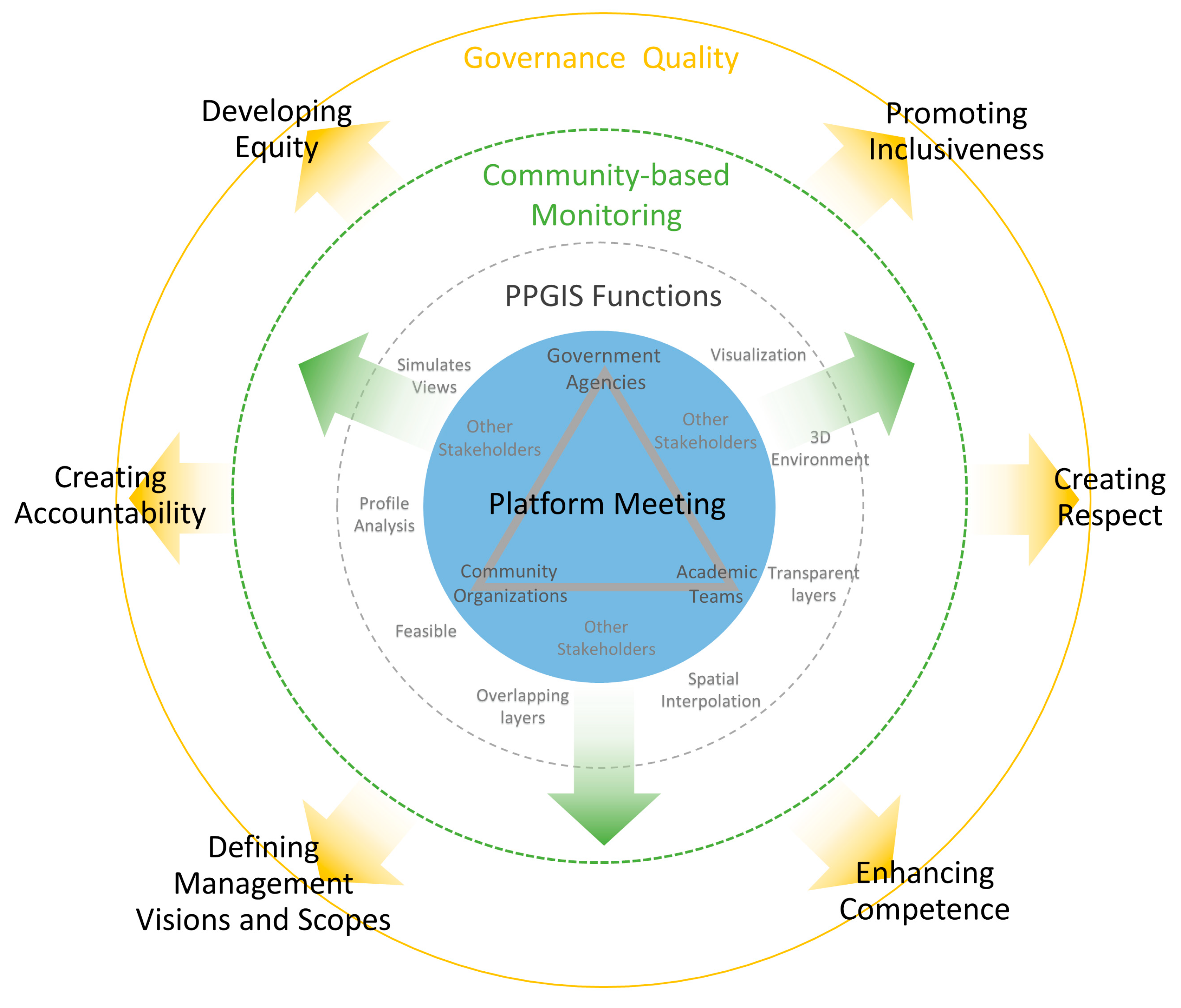
4. Results and Discussions: The Influence and Benefits of PPGIS

4.1. Promoting Inclusiveness

PPGIS views GIS as a form of visible communication that has the ability to present environmental information and to encourage grassroots participation [10,22,23]. The impact of PPGIS on inclusiveness means to clarify and expand the following: who are included, who are empowered through the process, ownership of the product, and the type and degree of participation [36]. In this study, it was the local communities that noticed and raised the issue of hydrological variation and worked with the academic team to introduce PPGIS to explore the wetland situation. Apart from introducing PPGIS and analyzing related data in the beginning, WRCEA also participated in the planning and implementation of substratum elevation monitoring and they held a workshop (platform meeting) to invite stakeholders to jointly interpret the monitoring results. With the assistance of both the county government and the academic team, WRCEA later led a monitoring project on the wildlife refuge, sponsored by the program for Wetlands of National Importance in Taiwan in 2010.
“At that time, we first illustrated the wetland area in Google Earth; then, we discussed the best method for monitoring it with the academic team.”
(LC02)
“After we complete the first trial, we will use PPGIS to explain our ideas to the other community development associations. Also, we will find some volunteers to help with the monitoring.”
(LC05)
“The monitoring data displayed in the 3-D environment plays a very important role in our proposal writing and funding. The officials can clearly understand what we want to do, as well as the capabilities of the community.”
(LG02)
Apart from WRCEA’s participation in the whole monitoring process, PPGIS also played a role in information dissemination in the platform meeting to help understand the implementation and possible benefits of the entire project. In this case, the public sector provided recognition and administrative support for the monitoring project and they provided the required measurement equipment. More importantly, many community members were willing to serve as volunteers for elevation measurement. This process determined how the local conservation group and community members played key roles throughout the monitoring and subsequent management.
“Right at the start, the community said they wanted to take a measurement of the substratum elevation and we were shocked. However, using PPGIS to understand the community’s method of implementation, we could better know how to coordinate.”
(FB03)
“After this kind (PPGIS) of explanation, everyone could better understand, and it also helped to set up the needs of the academic team in the refuge. After several rounds of monitoring, we could go in and finish these facilities ourselves.”
(LC05)
“Through PPGIS, we could quickly grasp the silt distribution, and it is easier to reach a consensus with the community…. After everyone’s thinking is aligned, things can move forward more smoothly.”
(LC08)

4.2. Creating Respect

As a platform of environmental information gathering, PPGIS largely relies on the translation of stakeholders’ environmental experience and knowledge, thus increasing the source and diversity of decision-making information [21,26]. Living near this refuge for long periods of time, community members have an abundance of lay knowledge about the environment in the refuge, including its hydrology. The PPGIS workshop at the planning stage used the geospatial information platform to gather the community members’ lay knowledge about the water surrounding the refuge, and the participants jointly confirmed the scope of monitoring. Surprisingly, community volunteers used their lay knowledge to actively help the academic team resolve difficulties in designing and implementing the monitoring. This reduced the dependence of monitoring on professional equipment and the monitoring cost, thereby increasing the feasibility of subsequent monitoring. PPGIS also played a role in displaying the monitoring results, which allowed the stakeholders participating in the workshop, especially the local residents, to grasp clearly the elevation changes in the wetlands and to be able to compare them with the community members’ regular observation of hydrologic variation. These images and discussions also helped to prompt the local community’s historical memories of environment changes in the wetland. They shared their memories with other participants (such as the academic team and the public sector) in the PPGIS workshop to help everyone understand the history of wetland development and to raise community awareness of the value of wetlands.
“When I first started looking for an outside survey company to come in, as soon as they entered the wetland, they said it would be difficult to perform the measurement. Finally, it was ‘A’ who thought of some ways to set the water gauge in the refuge using the tools on hand.”
(LC04)
“The community volunteers used the buoys of the fishing nets to make a rope that can float on the surface of the water. As long as you measure according to the marked position on the rope, you can systematically obtain the elevation data.”
(AR02)
“When the map came out, we thought of the times in our childhood when we would go to the refuge and play in the water…. Under the water, there are still old water valves, and sometimes, we step on the gushing springs.”
(LC13)
“There are certain situations where there are people who can be called… citizen experts. They may have certain knowledge of the community and may also have a lot of professional knowledge. Spatial information tools such as PPGIS help transform their knowledge into data on the map.”
(AR03)

4.3. Enhancing Competence

PPGIS can improve the capacity of stakeholders; in other words, it can help stakeholders access geospatial information and improve their participation in communications and negotiations, according to References [31,70].
Using the free and easily accessible Google Earth, the academic team worked with WRCEA volunteers to collect information about bird distribution, wetland elevation, and interactions with the tides. Such information, together with the information about the zoning of this wildlife refuge and land use in the surrounding areas, played a key role in the discussion about refuge management and governance.
With 3-D and high-resolution display capabilities, Google Earth positively helped the stakeholders participating in the platform meeting to easily and clearly understand the dynamics of environmental resources within and nearby the refuge, thereby improving communication efficiency. The PPGIS not only transformed the monitoring data into a Google Earth 3-D environment but also improved management discussions by overlaying high resolution aerial photographs and other geospatial information (e.g., zoning, peripheral water systems, and hot spots of birds). The comparison of these geospatial data also allowed stakeholders to examine the integration of different management objectives from a more holistic perspective, thereby mitigating the management risk of uncertainty.
“After having a comprehensive view of the substratum elevation, everyone will be better off figuring out how to dredge, and then, we can avoid the destruction of the bird habitat in the refuge.”
(LC12)
“This kind of view makes everything clearer. You can clarify the discussion with the county government, and there will be no discrepancy between the two sides.”
(LP01)
“You can zoom in and out on the map very quickly, so we can immediately see that the water in the refuge is flowing from there…. Later, there is some monitoring taking place in that location of the river.”
(LC06)
“Using this method of comparison, we can know which part of the area should be dredged and it is also possible to avoid the bird habitats.”
(LC06)
Community members without any specialized background were able to compare substratum elevation data and silt locations with the visual information provided during the PPGIS workshop. Community members could also identify the location whirlpool and historical remains under water; as a result, they were able to integrate more local perspectives in their reading of the data.
The PPGIS did not merely contribute to the transformation of the decision-making mechanisms; it also helped local stakeholders effectively persuade government and academic stakeholders during the negotiations over actual management strategies. Through the above procedures, PPGIS improved the effectiveness of the stakeholder negotiations over management and reduced the cost of communication between stakeholders.
“This method of communication is very effective because the message is clearly presented and everyone can express what they want and will not be misunderstood…, so much so that it allows coordination.”
(LC08)

4.4. Defining the Management Visions and Scopes

Brown and Raymond [71], Brown and Fagerholm [72], and others mention that PPGIS could help stakeholders identify the characteristics of a refuge, map the residents’ values and preferences for the refuge, understand local land use and the locations of possible conflicts, and assist stakeholders in understanding the potential relationship between environmental resources and social culture, which were needed for decision-making.
PPGIS provided and displayed the environmental resource distribution and hydrological conditions of the refuge and its surrounding areas, substratum elevations, the depths and localities of mud, and even the river profile. These were key items of information for the platform meeting, which helped the participants understand the links within the overall refuge water system. The results helped to inform the Suao Township Office, the management authority of the six-sluice gate, as an important stakeholder. As all of the stakeholders learned about the land use of the wetlands and surrounding areas and the possible impact of management, in 2015, they supported expanding the spatial scope of the conservation plan, i.e., this refuge, to include surrounding paddy fields, agricultural lands, estuaries, hills, etc., so that the refuge could be considered from the larger landscape perspective and so that the zero loss of wetlands can be more viably considered.
Based on the geospatial information of the refuge, PPGIS helped the stakeholders build up a collective mechanism to allocate objectives, budgets, and human resources for implementing management. In addition, PPGIS also specifically linked the budget execution and division of labor under the management objectives so that stakeholders could work together on medium- and long-term planning of the refuge.
“Because of the discussion, it was later discovered that the six-sluice gate had great influence on the water source of the refuge. Therefore, it was decided to invite the people of the Luodong District Office to attend the meeting.”
(LC03)
“Because the map visualizes the water system data, it allows us to clearly see the relationship between these water systems and the refuge. The birds in the refuge will also go to the adjacent fields during floods… so during management discussions, we want [to] be included.”
(AC02)
“These tidal current investigations and substratum elevation monitoring, presented through PPGIS, can turn the land area issues in the refuge into issues for discussion. A substratum elevation monitoring was undertaken last year. We know what to do and how to do it this year. An elevation monitoring was done, and we know the changes in the water level, elevation, and silt distribution in the refuge. The elevation in the refuge is relatively high, and the water is easy to discharge.”
(AR01)
“When discussing management work items, we put the things that the community usually does on the map; therefore, the ways of implementing and dividing the labor are clearer. Everyone has a mechanism for coordination.”
(LC05)

4.5. Creating Accountability

PPGIS also helps ensure the implementation of transparent policy decisions [23,31]. In the process of PPGIS, empowerment is fostered, stakeholders’ capacity is built, and opportunities delivered by policy decisions are increased through this shift of power [25,28,35]. In the fieldwork for this study, at the platform meetings, PPGIS was used to help stakeholders clarify their visions and objectives, to discuss the division of labor, and to review the results so that stakeholders could understand the roles and functions of one another in the PA management. As a result, the transparency of the management process and decision making were improved and mutual accountability was achieved. This promoted the integration of mutual resources and enhanced the public sector’s willingness to entrust community members to carry out management work and to discuss budget allocations, thereby contributing to the realization of a mature partnership between the public and private sectors. Subsequently, community members continued to participate in the monitoring work and to routinely review management status; thus, they became the supervisors for the refuge. Overall, PPGIS helped with the sharing of rights and liabilities in governance and it also constructed an accountability mechanism in the governance process.
“After monitoring the substratum elevation these last two years, we found that the sedimentation in the refuge can be cleared out once. The records of these two years can be considered as the worst-case scenario and then serve as a reference point after complete dredging. By monitoring the siltification in the refuge for a long time, we can understand the status and speed of the siltification in the refuge.”
(AC01)
“When the county government is wrong, we can correct them. When they have an inappropriate view of the refuge, we can correct them and make them change the plan. When the government needs to carry out any management actions involving the refuge, we can provide assistance, supervision, and cooperation.”
(LC02)

4.6. Developing Equity

Brown [21] maintained that integrating professional and nonprofessional knowledge using PPGIS during the planning or decision-making process can be the basis for more in-depth public participation and thus affect the entire planning or decision-making process. In the case of Wu-Wei-Kang Wildlife Refuge, PPGIS improved the efficiency of the platform meetings and it helped with the establishment of equitable partnerships facilitated by cooperation between the public and private sectors. During the elevation monitoring, the role of community volunteers was transformed from consultants into working partners in management. In the past, decisions regarding the refuge were usually made by the academic team, which has professional competence. During the elevation monitoring practice, however, community members, with the assistance of PPGIS, acted together as the designers, executors, and data interpreters of the new community-based monitoring. PPGIS promoted the capacity to undertake refuge management of the local community by integrating and sharing its lay knowledge and labor and ensured the legitimacy and appropriateness of management decisions.
PPGIS reveals the correlation between the refuge and the surrounding environment by transforming the perspectives across different spatial scales. This correlation allows the stakeholders to integrate different spatial information (namely bird survey or land ownership). Meanwhile, PPGIS helps the stakeholders to compare the range and location of the silts for further assessment of their possible impacts on the wetland environment. This transparent information is shared among the stakeholders to assist them in reaching a consensus on the management of the refuge. The function of PPGIS in this process is (1) to integrate different information collected from different sources (LG02,LC04) and (2) to help the stakeholders set viable visions and goals in their management by taking advantage of the PPGIS’s expertise in spatial information (LC08,LC05).
Taking stock of the implementation process of PPGIS and community monitoring, this study found that, while community volunteers acted as information producers, the academic team acted as information analyzers and the government agencies acted as sponsors; they all worked together cooperatively to manage the refuge. The government agencies even adjusted the scope of annual dredging and allocation of budget based on the recommendations of community volunteers and the academic team. Meanwhile, the stakeholders also debated and negotiated over the subsequent management objectives for the refuge. Accordingly, the results showed that, through the process of elevation monitoring and PPGIS, a solid partnership was built up among the stakeholders, which could enhance equitable sharing of costs and benefits in the refuge management.
“Basically, as long as the process of spatialization can be completed, there will be some possibilities for connecting the relevant institutions because you know the environmental management issues, what kind of space you’re dealing with, and who the stakeholders are. You can then formulate the viable business management strategies.”
(LC07)
“The government wants to spend money; we want to do it, but there is no way. So, we need the help of academic teams to provide backup.... This data will provide a solution so that the refuge will not lack water in the future.”
(LC01)
“If there are many things, we can tell them what to do and what not to do; this is an ideal situation.”
(LG02)
“When the budget is being sought, the authorities will be more willing to grant support if the community has reached a consensus.”
(FB01)
In addition, the effects of PPGIS have already built up a brand-new style for information sharing and decision-making between the public and private sectors in this refuge. The local organizations are also gradually becoming the main executors in the management of the refuge. They are starting to play important roles in many different tasks including the determination of management objectives, habitat restoration, community communication, infrastructure maintenance, budget allocation, and execution of management activities. Of course, this new mechanism introduced by PPGIS has initiated extra debates between community organizations on distribution of work and resources. Fortunately, the majority of conflicts have been resolved as a result of the open communication and information transparency policy in the platform meeting. Thus, even the government agencies are willing to take the community opinions as the basis for developing relevant projects and to assist in funding for windbreaks management and zone planning of the wetland. Through the above process, the community volunteers will gradually transform from consultants to the producers of management information, the core participants in decision making, and even supervisors of refuge management.
We add Table 1 to present the overall findings of this study.

5. Conclusions

In the course of the present study, assisted by PPGIS, community members worked with the academic team in developing and implementing community-based monitoring of substratum elevation measurement, through which high-quality data was produced. These monitoring data were then represented by PPGIS in a way that allowed the stakeholders to grasp the overall changes and to negotiate plans for new management objectives and divisions of labor for the refuge. In this process, PPGIS was used to visualize the complex scientific method and scope so that community members could understand its implications and improve its implementation by lay knowledge and tools to reduce the monitoring cost. PPGIS also interpreted the results and checked their quality by means of public participation and used lay knowledge to expand the attributes of the monitoring results. Consequently, the data had both scientific and social characteristics. Such geospatial information, with both scientific and social attributes, not only enabled stakeholders to consider more factors in their decision making but also allowed them to consider specific management objectives and accountability by improving the effectiveness of negotiation and reducing communication costs. The PPGIS process also allowed other public sectors and academic teams to understand the importance and availability of lay knowledge for effective refuge and wetland management, which indirectly enhanced the influence of community members over the management of the refuge and wetland, thereby affecting the division of labor and funding for subsequent management. On the whole, PPGIS assisted in integrating local resources (including labor and knowledge) to improve the process and cost of collecting environmental information, and it confirmed the quality of monitoring data by means of public participation. In this way, stakeholders gradually developed mutual trust during the negotiation process and thereby improved the governance quality of this refuge.
This study showed that governance quality can provide an effective framework for investigating the impact of PPGIS application on the interaction, knowledge integration, capacity building, goal construction, accountability, and equity distribution of stakeholders in a refuge and wetland from the perspectives of participation and process. However, a longer term study will be required to grasp the impact of PPGIS on the overall governance process and its benefits. In addition, the participation of PPGIS stakeholders is a dynamic process, which involves various factors, such as personal motivation, knowledge, and ability. As governance quality rarely concerns individual participation motivation, our subsequent research will certainly include a focus on how to incorporate individual participation motivation into the governance quality category.
The transformation of experiences on PPGIS application is an important topic in relevant research fields. This study attempts to discuss the potential of PPGIS based on a relatively successful case study. However, more often, we have faced a management system of a PA that has never been designed with a public participation mechanism, a local community requiring more motivation to participate actively, or a scenario where access to the GITs and information is lacking.
Furthermore, continuous and systematic community monitoring imposes a significant challenge to the availability of human resources. Even in our case, not only have community organizers questioned the necessity of performance monitoring but also volunteers of WRCEA once opted to help another organization do bird survey in the Langyang River Open Wildlife Refuge, which is over 20 km away, rather than to complete the substratum elevation-monitoring. Therefore, in recent years, the research team has introduced a remote-controlled ship with a sonar measurement function to assist the substratum elevation-monitoring project and to conduct annual monitoring of the wetland areas, focusing on areas with silts. The use of a remote-controlled ship is expected to reduce the burden of human resources required for the WRCEA. The monitoring results collected from the remote-controlled ship will still be returned to the platform meeting for review and discussion by PPGIS after processing. Afterwards, the stakeholders will jointly decide the subsequent management strategy. However, the close integration of PPGIS with the governance issues puts higher demand on the quality of the spatial data. High-quality spatial data means high-yield costs. However, whether these costs can be afforded by the existing management systems is still a question that requires more case studies and time to answer.
The participation of stakeholders is considered as the basis for improving the quality of governance and the legitimacy of decision-making. The application of PPGIS not only assists stakeholders in participating in the discussion of management but also provides additional benefits from the empowerment brought by the stakeholders. Because WRCEA functions as the main executor of the community monitoring activity, the empowerment in this case mainly refers to WRCEA. While other local groups have also participated in discussions and decision-making, their overall contribution is still minor. It was still a big challenge to call for comprehensive participation of local people using the current mechanism. Meanwhile, there were also competitions and conflicts between government agencies with authority over this refuge, despite the availability of more detailed and transparent information for management decisions. The absence rate increased for stakeholders when there was once an attempt to have more frequent platform meetings. Therefore, there is still insufficient participation to transform the empowerment benefits from WRECA into the relationships with other community organizations as evidenced at this stage. Although the platform meeting continues to act as a communication platform, more cases are required to extract benefits from the platform meeting. Furthermore, since the Wu-Wei-Kang Wildlife Refuge is, to a certain extent, not directly related to local development, most local residents fail to dedicate enough effort to the management of the refuge. This is a challenge that PPGIS will need to face in the future.

Author Contributions

Conceptualization, M.-K.C., D.-J.L., B.-W.T. and K.-T.C.; Methodology, D.-J.L., and B.-W.T.; Investigation, M.-K.C., D.-J.L. and B.-W.T.; Data Curation, M.-K.C. and D.-J.L.; Writing Original Draft Preparation, M.-K.C. and D.-J.L.; Writing Review & Editing, B.-W.T. and K.-T.C.

Funding

This research was supported by the Ministry of Science and Technology, grant numbers (MOST 105-2119-M-002-054-MY2-) and (MOST 107-2119-M-002-043-).

Acknowledgments

We are grateful to WRCEA, the stakeholders from public and private sectors, and the academic team from National Taiwan University for the great help they provided in the field and related interviews in order to complete this study. We thank those friends who helped us, particularly WRCEA, the Ilan County Government, and the Loudong Forest District Office. Without their involvement and support, it would not have been possible to complete this study. We also thank Kirill Thompson, Scanlon Brian Timothy and Enago™ Services for their sincere help in English editing. Thanks for Guan-Yen Lu, Hao-Yun Chen, and Xin-Xin Lai for their help collecting geospatial information, preparing figures, and editing.

Conflicts of Interest

The authors declare no conflict of interest.

Appendix A

Table A1. List of Informants.
Informant No.OrganizationOccupation/RoleRecords by InterviewRecords by Participant Observation
LC01Members of WRCEADirector21
LC02Former Board Director22
LC03Director45
LC04Board Director1
LC05Executive Secretary13
LC06Director14
LC07Director11
LC08Former Board Director16
LC09Director1
LC10Director1
LC11Member11
LC12Assistant13
LC13Volunteer1
LC14Volunteer1
LC15Volunteer1
LC16Volunteer1
LP01Community ResidentsChief of Village.11
LP02Chief of Village.1
LP03Principal1
AC01Scholars and ExpertsHydraulic Engineer1
AC02Wildlife Expert1
AC03Benthos Expert1
FB01Luodong Forest District OfficeForestry Officer2
FB02Forestry Officer1
FB03Senior Forestry Officer1
FB04Forestry Officer2
LG01Ilan County GovernmentSection Manager2
LG02Conservation Officer17
AR01Academic TeamConservation Specialist2
AR02GIS Specialist1
AR03GIS Specialist2
Total2550
P.S. LC-current members and volunteers of WRCEA; LP—local residents not members of WRCEA; AC—academics; LG—officers of local government; FB—forestry officers; AR—this research team.
Table A2. List of Occasions for Participant Observation.
Occasion No.DataMajor ActivitiesInformant No.
P012009/02/14Platform MeetingAR01,LC02
P022009/07/17Test of SEM 1 methodsLC08
P032009/08/18Platform MeetingLG02,LC03
P042009/08/29Wetland on-site inspectionAC03,LG02
P052009/11/19Review Meeting of Wetlands of ImportanceFB04,LG01,LC02
P062010/07/30TCI 2 meetingLC03,LC12
P072010/08/21Setting up facilities for SEMLP01,LP02
P082009/09/04Wetland Deposition MeetingFB04,LG01
P092010/09/11Setting up facilities for SEMLC08,LC06
P102010/9/18Wildlife Refuge Management Effectiveness Evaluation meetingLC08,LG02
P112010/09/25TCILC08
P122010/10/09SEM in wetlandLC07
P132010/10/30SEM in neighboring aqueductLC03
P142011/03/05Monitoring Results PresentationAR02,LC12
P152011/04/16Setting up facilities for SEMLC06
P162011/05/22TCILC08
P172011/05/30SEM in wetlandLC03
P182011/07/29SEM in neighboring aqueductLC06
P192011/08/05Monitoring Results PresentationAR01,LC03
P202011/08/06Platform MeetingLC08,LG02
P212011/09/24TCILC10
P222011/10/11Review Meeting of Community Forestry ProjectFB03,LG02
P232011/11/28SEM by remote-controlled shipLC06
P242012/02/18General Meeting of WRCEALC05,LC12
P252012/06/02Platform MeetingAC02
P262012/12/11SEM by remote-controlled shipLC14
P272013/12/14SEM by remote-controlled shipLC11
P282013/12/25Platform MeetingLP03
P292015/06/13Platform MeetingLC05,LG02
P302015/08/03Land Acquisition MeetingAR02,LC03
P312015/09/25SEMLC15
P322015/10/31Platform MeetingLC05,LG02
1 Substratum Elevation Monitoring. 2 Tidal Current Investigation.

References

  1. Watson, J.E.M.; Dudley, N.; Segan, D.B.; Hockings, M. The performance and potential of protected areas. Nature 2014, 515, 67–73. [Google Scholar] [CrossRef] [PubMed]
  2. Macura, B.; Laura Secco, L.; Pullin, A.S. What evidence exists on the impact of governance type on the conservation effectiveness of forest protected areas? Knowledge base and evidence gaps. Environ. Evid. 2015, 4, 24. [Google Scholar] [CrossRef]
  3. Corral, S.; Monagas, M.C. Social involvement in environmental governance: The relevance of quality assurance processes in forest planning. Land Use Policy 2017, 67, 710–715. [Google Scholar] [CrossRef]
  4. Phillips, A. Turning ideas on their head: The new paradigm for protected areas. George Wright Forum 2003, 20, 8–32. [Google Scholar]
  5. Renn, O. Participatory processes for designing environmental policies. Land Use Policy 2006, 23, 34–43. [Google Scholar] [CrossRef]
  6. Borrini-Feyerabend, G.; Hill, R. Governance for the conservation of nature. In Protected Area Governance and Management; Worboys, G.L., Lockwood, M., Kothari, A., Feary, S., Pulsford, I., Eds.; ANU Press: Canberra, Australia, 2015; pp. 169–206. [Google Scholar]
  7. Irwin, F.; Ranganathan, J. Restoring Nature’s Capital: An Action Agenda to Sustain Ecosystem Services; World Resources Institute: Washington, DC, USA; Available online: https://www.researchgate.net/ (accessed on 25 May 2018).
  8. Hellier, A.; Newton, A.; Gaona, S. Use of Indigenous Knowledge for Rapidly Assessing Trends in Biodiversity: A Case Study from Chiapa, Mexico. Biol. Conserv. 1999, 8, 869–889. [Google Scholar]
  9. Lockwood, M. Good governance for terrestrial protected areas: A framework, principles and performance outcomes. J. Environ. Manag. 2010, 91, 754–766. [Google Scholar] [CrossRef] [PubMed]
  10. Borrini-Feyerabend, G.; Dudley, N.; Jaeger, T.; Lassen, B.; Broome, N.P.; Phillips, A.; Sandwith, T. Governance of Protected Areas: From understanding to Action; IUCN: Gland, Switzerland, 2013. [Google Scholar]
  11. Green, D.R. The role of Public Participatory Geographical Information Systems (PPGIS) in coastal decision-making processes: An example from Scotland, UK. Ocean Coast Manag. 2010, 53, 816–821. [Google Scholar] [CrossRef]
  12. Haklay, M.; Francis, L. Participatory GIS and community-based citizen science for environmental justice action. In The Routledge Handbook of Environmental Justice; Chakraborty, J., Walker, G., Holifield, R., Eds.; Routledge: Abingdon, UK, 2018; pp. 297–308. [Google Scholar]
  13. Ghose, R. Use of information technology for community empowerment: Transforming geographic information system into community information systems. Trans. GIS 2001, 5, 141–163. [Google Scholar] [CrossRef]
  14. Curry, M.R. The digital individual and the private realm. Ann. Assoc. Am. Geogr. 1997, 87, 681–699. [Google Scholar] [CrossRef]
  15. Chrisman, N. Full circle: More than just social implications of GIS. Cartographica 2005, 40, 23–35. [Google Scholar] [CrossRef]
  16. Ramsey, K. A call for agonism: GIS and the politics of collaboration. Environ. Plan. A 2008, 40, 2346–2363. [Google Scholar] [CrossRef]
  17. Israel, B.A.; Eng, E.; Schulz, A.J.; Parker, E.A. Methods in Community-Based Participatory Research for Health; Jossey-Bass: San Francisco, CA, USA, 2005. [Google Scholar]
  18. Sheppard, E. Knowledge production through critical GIS: Genealogy and prospects. Cartographica 2005, 40, 5–21. [Google Scholar] [CrossRef]
  19. Rambaldi, G.; Chambers, R.; McCall, M.; Fox, J. Practical ethics for PGIS practitioners, facilitators, technical intermediaries and researchers. PLA 2006, 54, 106–113. [Google Scholar]
  20. Anderson, C.; Beazley, K.; Boxall, J. Lessons for PPGIS from the application of a decision-support tool in the Nova Forest Alliance of Nova Scotia, Canada. J. Environ. Manag. 2009, 90, 2081–2089. [Google Scholar] [CrossRef]
  21. Brown, G. Public Participation GIS (PPGIS) for regional and environmental planning: Reflections on a decade of empirical research. J. URISA 2012, 25, 5–16. [Google Scholar]
  22. Engen, S.; Runge, C.; Brown, G.; Fauchald, P.; Nilsen, L.; Hausner, V. Assessing local acceptance of protected area management using public participation GIS (PPGIS). J. Nat. Conserv. 2018, 43, 27–34. [Google Scholar] [CrossRef] [Green Version]
  23. Sieber, R.E. Geographic Information Systems AAin the Environ-mental Movement. In Community Participation and Geographic Information Systems; Craig, W., Harris, T., Weiner, D., Eds.; Taylor and Francis: London, UK, 2002; pp. 153–172. [Google Scholar]
  24. Elwood, S. Grassroots groups as stakeholders in spatial data infrastructures: Challenges and opportunities for local data development and sharing. Int. J. Geogr. Inf. Sci. 2008, 22, 71–90. [Google Scholar] [CrossRef]
  25. Brown, G. Engaging the wisdom of crowds and public judgment for land use planning using public participation geographic information systems. Aust. Plan. 2015, 52, 199–209. [Google Scholar] [CrossRef]
  26. Elwood, S. Beyond cooptation or resistance: Urban spatial politics, community organizations, and GIS-based spatial narratives. Ann. Assoc. Am. Geogr. 2006, 96, 323–341. [Google Scholar] [CrossRef]
  27. Tsai, B.W.; Lu, D.J.; Chung, M.K.; Lien, M.C. Evaluation of PPGIS Empowerment: A case study of Meinong Yellow Butterfly Valley in Taiwan. J. Environ. Manag. 2013, 116, 204–212. [Google Scholar] [CrossRef]
  28. Thompson, M.M. Upside-Down GIS: The Future of Citizen Science and Community Participation. Cartogr. J. 2016, 53, 326–334. [Google Scholar] [CrossRef]
  29. Dunn, C.E. Participatory GIS—A people’s GIS? Prog. Hum. Geog. 2007, 31, 616–637. [Google Scholar] [CrossRef]
  30. Brown, G. An empirical evaluation of the spatial accuracy of public participation GIS (PPGIS) data. Appl. Geogr. 2012, 34, 289–294. [Google Scholar] [CrossRef]
  31. Chambers, R. Participatory Mapping and Geographic Information Systems: Whose Map? Who is Empowered and Who Disempowered? J. Inform. Syst. Dev. 2006, 25, 1–11. [Google Scholar] [CrossRef]
  32. Brown, G.; Kyttä, M. Key issues and research priorities for public participation GIS (PPGIS): A synthesis based on empirical research. Appl. Geogr. 2014, 46, 122–136. [Google Scholar] [CrossRef]
  33. Corbett, J.; Cochrane, L.; Gill, M. Powering up: Revisiting participatory GIS and empowerment. Cartogr. J. 2016, 53, 335–340. [Google Scholar] [CrossRef]
  34. McCall, M.K. Seeking good governance in participatory-GIS: A review of processes and governance dimensions in applying GIS to participatory spatial planning. Habitat Int. 2003, 27, 549–573. [Google Scholar] [CrossRef]
  35. Cinderby, S.; Snell, C.; Forrester, J. Participatory GIS and its application in governance: The example of air quality and the implications for noise pollution. Local Environ. 2008, 13, 309–320. [Google Scholar] [CrossRef]
  36. McCall, M.K.; Dunn, C.E. Geo-information tools for participatory spatial planning: Fulfilling the criteria for ‘good’ governance? Geoforum 2012, 43, 81–94. [Google Scholar] [CrossRef]
  37. Pfeffer, K.; Baud, I.; Denis, E.; Scott, D.; Sydenstricker-Neto, J. Participatory spatial knowledge management tools. Information. Commun. Soc. 2013, 16, 258–285. [Google Scholar] [CrossRef]
  38. Brown, G.; Weber, D.; de Bie, K. Is PPGIS good enough? An empirical evaluation of the quality of PPGIS crowd-sourced spatial data for conservation planning. Land Use Policy 2015, 43, 228–238. [Google Scholar] [CrossRef]
  39. Haklay, M.; Jankowski, P.; Zwoliński, Z. Selected modern methods and tools for public participation in urban planning—A review. Quaest. Geogr. 2018, 37, 127–149. [Google Scholar] [CrossRef]
  40. Sun, T.W.; Tsai, Y.T.; Shih, M.C.; Lin, Y.W. Public participation and the concept of space in environmental governance: An application of PPGIS. Public Adm. Dev. 2009, 29, 250–261. [Google Scholar] [CrossRef]
  41. Raymond, C.M.; Bryan, B.A.; MacDonald, D.H.; Cast, A.; Strathearn, S.; Grandgirard, A.; Kalivas, T. Mapping community values for natural capital and ecosystem services. Ecol. Econ. 2010, 68, 1301–1315. [Google Scholar] [CrossRef]
  42. Ganapati, S. Uses of Public Participation Geographic Information Systems Applications in E-Government. Public Adm. Rev. 2010, 71, 425–434. [Google Scholar] [CrossRef]
  43. Linnell, J.D.C.; Kaczensky, P.; Wotschikowsky, U.; Lescureux, N.; Boitani, L. Framing the relationship between people and nature in the context of European conservation. Conserv. Biol. 2015, 29, 978–985. [Google Scholar] [CrossRef] [Green Version]
  44. Dudley, N.; Parrish, J.; Redford, K.; Stolton, S. The revised IUCN protected area management categories: The debate and ways forward. Oryx 2010, 44, 485–490. [Google Scholar] [CrossRef]
  45. Weaver, D.; Lawton, L. A new visitation paradigm for protected areas. Tour. Manag. 2017, 60, 140–146. [Google Scholar] [CrossRef]
  46. Hockings, M.; Leverington, F.; Cook, C. Protected area management effectiveness. In Protected Area Governance and Management; Worboys, G.L., Lockwood, M., Kothari, A., Feary, S., Pulsford, I., Eds.; ANU E Press: Canberra, Australia, 2015; pp. 889–928. [Google Scholar]
  47. Geldmann, J.; Coad, L.; Barnes, M.; Craigie, I.D.; Hockings, M.; Knights, K.; Leverington, F.; Cuadros, I.C.; Zamora, C.; Woodley, S.; et al. Changes in protected area management effectiveness over time: A global analysis. Biol. Conserv. 2015, 191, 692–699. [Google Scholar] [CrossRef]
  48. Hockings, M.; Cook, C.; Carter, R.W.; James, R. Accountability, Reporting or Management Improvement? Development of a State of the Parks Assessment System in New South Wales, Australia. Environ. Manag. 2009, 43, 1013–1025. [Google Scholar] [CrossRef]
  49. Graham, J.; Amos, B.; Plumptre, T. Governance Principles for Protected Areas in the 21st Century; Institute on Governance, Parks Canada and the Canadian International Development Agency: Ottawa, ON, Canada, 2003.
  50. United Nations Development Programme (UNDP). Governance for Sustainable Human Development; UNDP: New York, NY, USA, 1997. [Google Scholar]
  51. Lockwood, M.; Davidson, J.; Curtis, A.; Stratford, E.; Griffith, R. Governance Principles for Natural Resource Management. Soc. Nat. Resour. 2010, 23, 986–1001. [Google Scholar] [CrossRef]
  52. Turner, R.A.; Fitzsimmons, C.; Forster, J.; Mahon, R.; Peterson, A.; Stead, S.M. Measuring good governance for complex ecosystems: Perceptions of coral reef-dependent communities in the Caribbean. Glob. Environ. Chang. 2014, 29, 105–117. [Google Scholar] [CrossRef] [Green Version]
  53. Chuenpagdee, R. Interactive governance for marine conservation: An illustration. Bull. Mar. Sci. 2011, 87, 197–211. [Google Scholar] [CrossRef]
  54. Eklund, J.; Cabeza, M. Quality of governance and effectiveness of protected areas: Crucial concepts for conservation planning. Ann. N. Y. Acad. Sci. 2017, 1399, 27–41. [Google Scholar] [CrossRef]
  55. Berkes, F. Understanding uncertainty and reducing vulnerability: Lessons from resilience thinking. Nat. Hazards 2007, 41, 283–295. [Google Scholar] [CrossRef]
  56. Dressler, W.; Büscher, B.; Schoon, M.; Brockington, D.; Hayes, T.; Kull, C.A.; McCarthy, J.; Shrestha, K. From hope to crisis and back again? A critical history of the global CBNRM narrative. Environ. Conserv. 2010, 37, 5–15. [Google Scholar] [CrossRef] [Green Version]
  57. Lemos, M.C.; Agrawal, A. Environmental Governance. Ann. Rev. Env. Resour. 2006, 31, 297–325. [Google Scholar] [CrossRef]
  58. Drazkiewicz, A.; Challies, E.; Newig, J. Public participation and local environmental planning: Testing factors influencing decision quality and implementation in four case studies from Germany. Land Use Policy 2015, 46, 211–222. [Google Scholar] [CrossRef]
  59. Kisingo, A.; Rollins, R.; Murray, G.; Dearden, P.; Clarke, M. Evaluating ‘good governance’: The development of a quantitative tool in the Greater Serengeti Ecosystem. J. Environ. Manag. 2016, 181, 749–755. [Google Scholar] [CrossRef]
  60. Lu, D.J.; Chao, C.L.; Chueh, H.C.; Kao, C.W.; Chang, Y.L.; Chang, H.Y. Evaluating the Management Effectiveness of the Protected Areas in Taiwan Analysis and Interpretation of 5 Case Studies. J. Geogr. Sci. 2011, 62, 73–105. (In Chinese) [Google Scholar]
  61. Lu, D.J.; Chao, C.L.; Lo, S.Y.; Kao, C.W.; Chen, Y.L.; Lo, L.C.; Yeh, M.C.; Ho, L.D.; Chang, H.Y.; Wang, J.Y. Evaluating Management Effectiveness of the Coastal and Estuarine Protected Areas in Taiwan. J. Geogr. Sci. 2013, 68, 19–42. (In Chinese) [Google Scholar]
  62. Ilan County Government. 2015 Wu-Wei-Kang Wildlife Refuge Conservation Plan; Ilan County Government: Ilan, Taiwan, 2015. (In Chinese)
  63. Ministry of the Interior. Wu-Wei-Kang National Important Wetland Conservation Plan; Ministry of the Interior: Taipei, Taiwan, 2017. (In Chinese)
  64. Lu, D.J.; Wang, M.N.; Chueh, H.C. Assessing Management Effectiveness of the Wu-Wei-Kang Wildlife Refuge: The Introduction and Applicability of RAPPAM. J. Geogr. Sci. 2008, 54, 51–78. (In Chinese) [Google Scholar]
  65. Lu, D.J.; Kao, C.W.; Chao, C.L. Evaluating the management effectiveness of five protected areas in Taiwan using WWF’s RAPPAM. Environ. Manag. 2012, 50, 272–282. [Google Scholar] [CrossRef]
  66. Lin, Y. Employment of Spatial Information Technology on Community Monitoring—A Case of Avian Survey at Yilan Wu-Wei-Gong Area. Master’s Thesis, National Taiwan University, Taipei, Taiwan, 2010. (In Chinese). [Google Scholar]
  67. Peng, A.C. Implementing and Studying Community-Based Monitoring—A Case Study of the Wu-Wei-Kang Waterfowl Refuge. Master’s Thesis, National Taiwan University, Taipei, Taiwan, 2011. (In Chinese). [Google Scholar]
  68. Lu, Y.W. The Operation and Local Role of Wu-Wei River Cultural and Education Association. Master’s Thesis, National Taiwan University, Taipei, Taiwan, 2013. (In Chinese). [Google Scholar]
  69. Hsieh, H.L. Exploring Community Capacity in Community-Based Natural Resource Management. Master’s Thesis, National Taiwan University, Taipei, Taiwan, 2017. (In Chinese). [Google Scholar]
  70. Elwood, S. GIS and collaborative urban governance: Understanding their implications for community action and power. Urban Geogr. 2002, 22, 737–759. [Google Scholar] [CrossRef]
  71. Brown, G.; Raymond, C.M. Methods for identifying land use conflict potential using participatory mapping. Landsc. Urban Plan. 2014, 122, 196–208. [Google Scholar] [CrossRef]
  72. Brown, G.; Fagerholm, N. Empirical PPGIS/PGIS mapping of ecosystem services: A review and evaluation. Ecosyst. Serv. 2015, 13, 119–133. [Google Scholar] [CrossRef]
Figure 1. Wu-Wei-Kang Wildlife Refuge.
Sustainability 11 04154 g001
Figure 2. The platform meeting in Wu-Wei-Kang Wildlife Refuge.
Sustainability 11 04154 g002
Figure 3. Elevation monitoring results of the wetland.
Sustainability 11 04154 g003
Figure 4. The research framework to explore how Public Participation Geographic Information System (PPGIS) influences the governance quality of this refuge.
Sustainability 11 04154 g004
Table 1. Effects to apply PPGIS on improving governance quality of a protected area.
Governance QualitySuitability of GITsThe Efficacy of PPGIS
Promoting InclusivenessVisualization
3-D environment
Transparent layers
Feasible
Explore the environmental situation
Help to plan the monitoring method
Mobilize volunteers
Disseminate information
Creating RespectVisualization
3-D environment
Transparent layers
Overlapping layers
Gather the community members’ lay knowledge
Prompt the local community’s historical memories
Help stakeholders to understand the history of wetland
Raise the community’s awareness of the environmental value
Enhancing CompetenceVisualization
3-D environment
Transparent layers
Overlapping layers
Help stakeholders to understand the dynamics of environmental resources
Improve stakeholders’ communication ability
Improve discussions of management
Help local stakeholders to persuade stakeholders in other sectors
Defining Management Visions and ScopesSpatial interpolation
3-D environment
Overlapping layers
Feasible
Profile analysis
Simulates views
Help to understand the distribution of local environmental resource
Help to identify potential stakeholders
Help to define management visions and scopes
Help to expand the spatial scope of the conservation plan
Help the stakeholders to build up a collective mechanism to allocate objectives, budgets, and human resources
Creating AccountabilityVisualization
3-D environment
Transparent layers
Feasible
Help stakeholders to review the management results
Transparency of the decision-making process
Integration of mutual resources
Contribute to the realization of a mature partnership
Sharing of rights and liabilities in governance
Developing EquityVisualization
3-D environment
Feasible
Help the establishment of equity between the public and private sectors
Ensure the legitimacy and appropriateness of management decisions
Enhance equitable sharing of costs and benefits in the refuge management

