Analysis of Forest Deforestation and its Driving Factors in Myanmar from 1988 to 2017
Abstract
1. Introduction
2. Materials and Methods
2.1. Study Area and Data
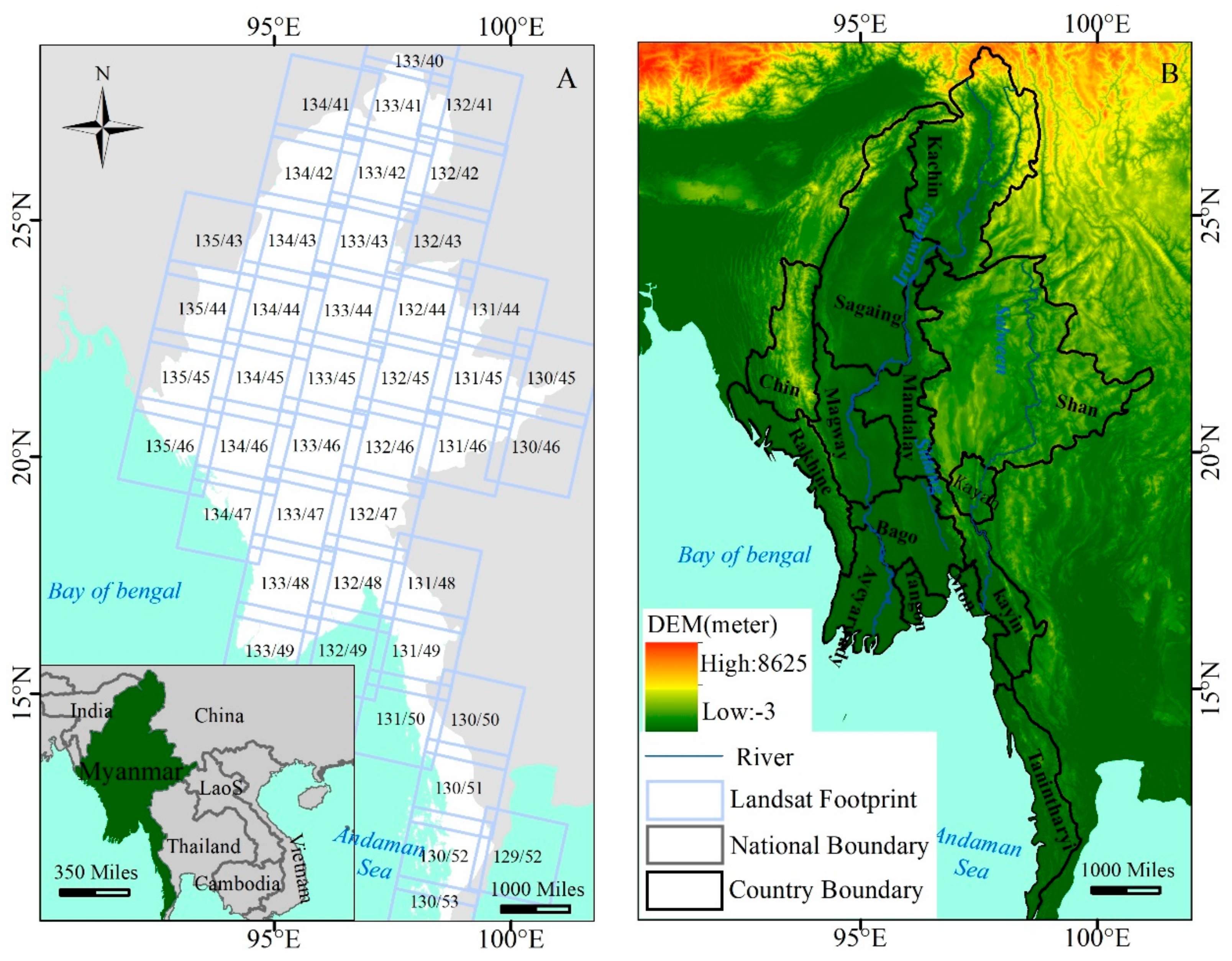
2.1.1. Study Area
2.1.2. Data
2.2. Methods
2.2.1. Data Preprocessing
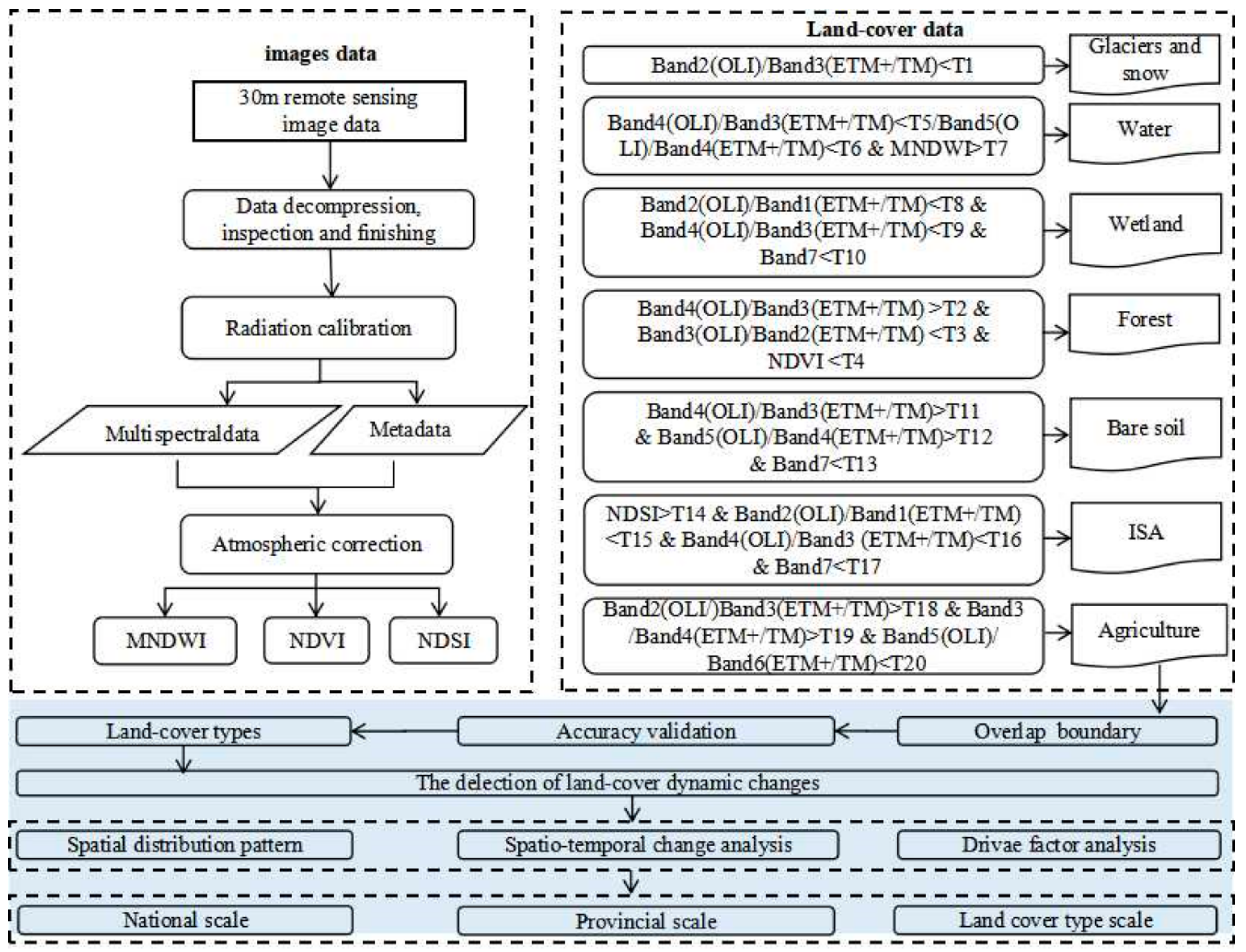
2.2.2. Extraction of Index
2.2.3. Land-Cover Classification
2.2.4. Accuracy Evaluation Method
3. Results
3.1. Accuracy Analysis of Myanmar Land Cover Classification Results
3.2. Spatial and Temporal Distribution of Forest and Its Changing Characteristics
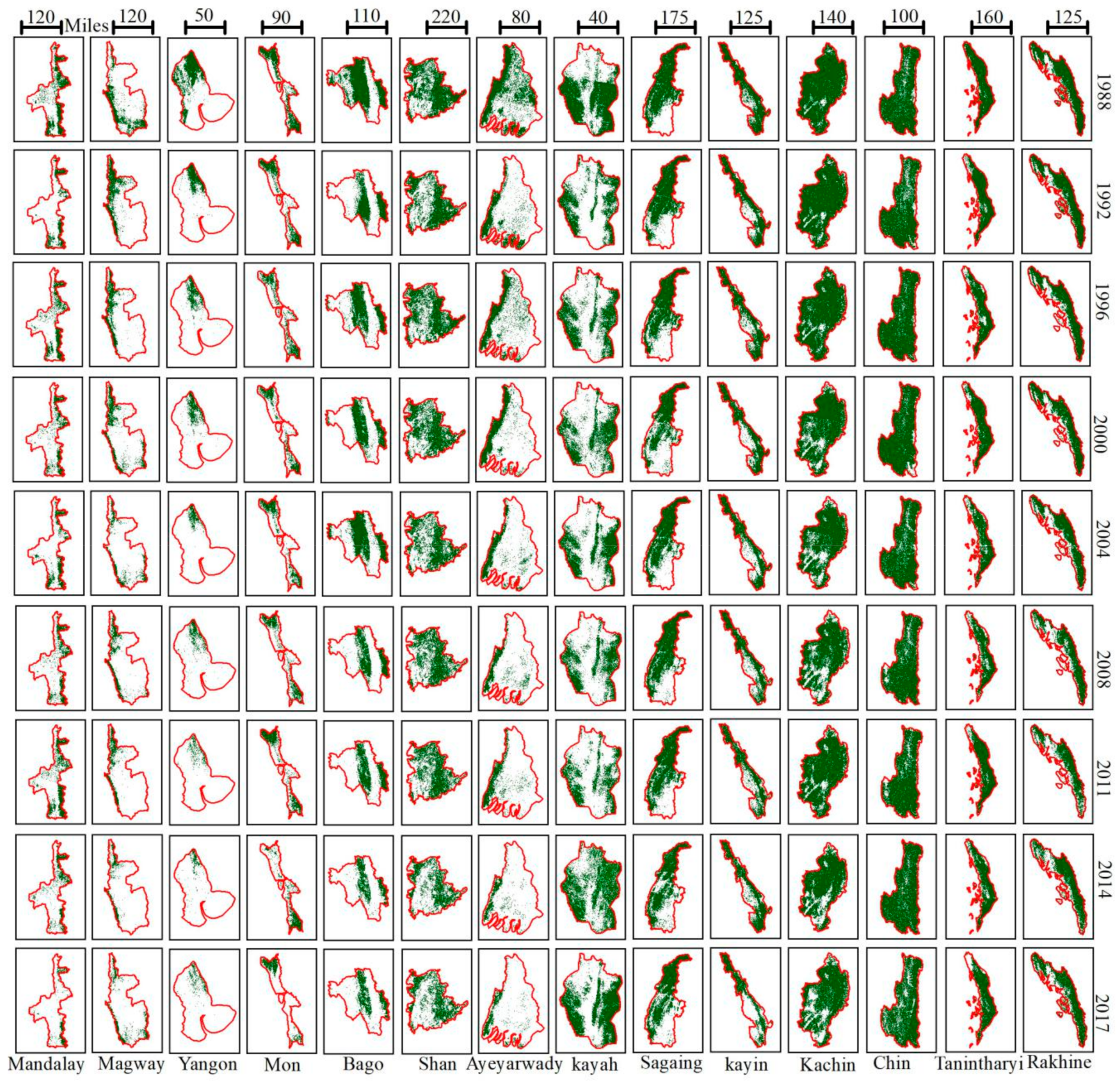
3.2.1. Spatial and Temporal Forest Distribution
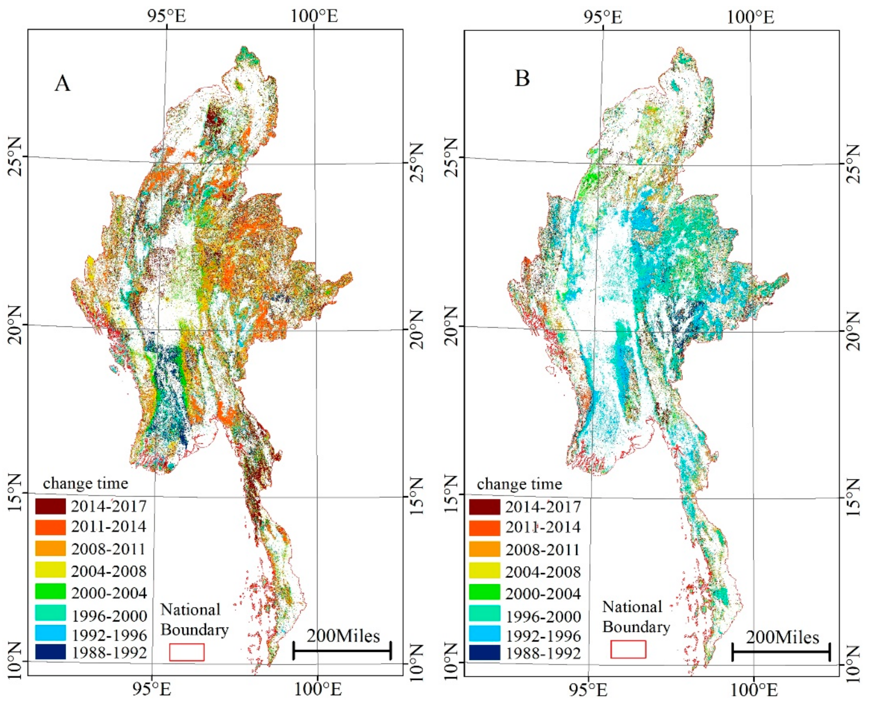
3.2.2. Forest Cover Dynamics between 1988 and 2017
3.2.3. Forest Cover Transfer Characteristic
3.2.4. Deforestation Rates between 1988 and 2017
3.3. Driving Forces of Forest deforestation
4. Discussion
5. Conclusions
Supplementary Materials
Author Contributions
Funding
Conflicts of Interest
References
- Foley, J.A. Atmospheric science. Tipping points in the tundra. Science 2005, 310, 627. [Google Scholar] [CrossRef]
- Alkama, R.; Cescatti, A. Biophysical climate impacts of recent changes in global forest cover. Science 2016, 351, 600–604. [Google Scholar] [CrossRef] [PubMed]
- Gullison, R.E.; Frumhoff, P.C.; Canadell, J.G. Tropical Forests and Climate Policy. Science 2007, 316, 985–986. [Google Scholar] [CrossRef]
- Yang, K.; Yu, Z.; Luo, Y. Spatial and temporal variations in the relationship between lake water surface temperatures and water quality—A case study of Dianchi Lake. Sci. Total Environ. 2018, 624, 859–871. [Google Scholar] [CrossRef] [PubMed]
- Feddema, J.J. The Importance of Land-Cover Change in Simulating Future Climates. Science 2005, 310, 1674–1678. [Google Scholar] [CrossRef] [PubMed]
- Lawrence, D.; Vandecar, K. Effects of tropical deforestation on climate and agriculture. Nat. Clim. Chang. 2014, 5, 27–36. [Google Scholar] [CrossRef]
- Achard, F.; Eva, H.D.; Stibig, H.-J. Determination of deforestation rates of the world’s humid tropical forests. Science 2002, 297, 999–1002. [Google Scholar] [CrossRef] [PubMed]
- Wilcove, D.S.; Giam, X.; Edwards, D.P. Navjot’s nightmare revisited: Logging, agriculture and biodiversity in Southeast Asia. Trends Ecol. Evol. 2013, 28, 531–540. [Google Scholar] [CrossRef]
- Tropek, R.; Sedláček, O.; Beck, J. Comment on Comment on “High-resolution global maps of 21st-century forest cover change”. Science 2014, 344, 981. [Google Scholar] [CrossRef] [PubMed]
- FAO. Global Forest Resources Assessment 2000 (FRA 2000); Food and Agriculture Organizations of the United Nations: Rome, Italy, 2000. [Google Scholar]
- Songer, M.; Aung, M.; Senior, B. Spatial and temporal deforestation dynamics in protected and unprotected dry forests: A case study from Myanmar (Burma). Biodiver. Conserv. 2009, 18, 1001–1018. [Google Scholar] [CrossRef]
- Bhagwat, T.; Hess, A.; Horning, N. Losing a jewel-Rapid declines in Myanmar’s intact forests from 2002–2014. PLoS ONE 2017, 12, e0176364. [Google Scholar] [CrossRef]
- Chuyuan, W.; Soe, M. Environmental Concerns of Deforestation in Myanmar 2001–2010. Remote Sens. 2016, 8, 728. [Google Scholar] [CrossRef]
- Mon, M.S.; Mizoue, N.; Htun, N.Z. Factors affecting deforestation and forest degradation in selectively logged production forest: A case study in Myanmar. For. Ecol. Manag. 2012, 267, 190–198. [Google Scholar] [CrossRef]
- Leimgruber, P.; Kelly, D.S.; Steininger, M.K. Forest cover change patterns in Myanmar (Burma) 1990–2000. Environ. Conserv. 2005, 32, 356. [Google Scholar] [CrossRef]
- Webb, E.L.; Jachowski, N.R.A.; Phelps, J. Deforestation in the Ayeyarwady Delta and the conservation implications of an internationally-engaged Myanmar. Glob. Environ. Chang. 2014, 24, 321–333. [Google Scholar] [CrossRef]
- Renner, S.C.; Rappole, J.H.; Leimgruber, P. Land cover in the Northern Forest Complex of Myanmar: New insights for conservation. Oryx 2007, 41, 27–37. [Google Scholar] [CrossRef]
- Htun, N.Z.; Mizoue, N.; Kajisa, T. Deforestation and forest degradation as measures of Popa Mountain Park (Myanmar) effectiveness. Environ. Conserv. 2009, 36, 218. [Google Scholar] [CrossRef]
- Sexton, J.O.; Noojipady, P.; Song, X.P. Conservation policy and the measurement of forests. Nat. Clim. Chang. 2015, 6. [Google Scholar] [CrossRef]
- Wulder, M.A.; Masek, J.G.; Cohen, W.B. Opening the archive: How free data has enabled the science and monitoring promise of Landsat. Remote Sens. Environ. 2012, 122, 2–10. [Google Scholar] [CrossRef]
- Hassan, M.M. Monitoring land use/land cover change, urban growth dynamics and landscape pattern analysis in five fastest urbanized cities in Bangladesh. Remote Sens. Appl. Soc. Environ. 2017, 7, 69–83. [Google Scholar] [CrossRef]
- Turner, W.; Spector, S.; Gardiner, N. Remote sensing for biodiversity science and conservation. Trends Ecol. Evol. 2003, 18, 306–314. [Google Scholar] [CrossRef]
- Moran, E.F.; Brondizio, E.; Mausel, P. Integrating Amazonian Vegetation, Land-Use, and Satellite Data. Bioscience 1994, 44, 329–338. [Google Scholar] [CrossRef]
- Steininger, M.K. Tropical secondary forest regrowth in the Amazon: Age, area and change estimation with Thematic Mapper data. Int. J. Remote Sens. 1996, 17, 9–27. [Google Scholar] [CrossRef]
- Kun, Y.; Meie, P.; Yi, L. A time-series analysis of urbanization-induced impervious surface area extent in the Dianchi Lake watershed from 1988–2017. Int. J. Remote Sens. 2018, 40, 1–20. [Google Scholar] [CrossRef]
- Bryant, R. The Political Ecology of Forestry in Burma 1824–1994; University of Hawaii Press: Honolulu, HI, USA, 1997. [Google Scholar]
- Seekins, D.M. Historical Dictionary of Burma (Myanmar), Historical Dictionaries of Asia, Oceania, and the Middle East, No. 59; The Scarecrow Press, Inc: Lanham, MD, USA, 2006. [Google Scholar]
- Pimm, S.L.; Jenkins, C.N.; Abell, R. The biodiversity of species and their rates of extinction, distribution, and protection. Science 2014, 344. [Google Scholar] [CrossRef]
- Myers, N.; Mittermeier, R.A.; Mittermeier, C.G. Biodiversity hotspot for conservation priorities. Nature 2000, 403, 853–858. [Google Scholar] [CrossRef]
- Barbier, E.B. Explaining Agricultural Land Expansion and Deforestation in Developing Countries. Am. J. Agric. Econ. 2004, 86, 1347–1353. [Google Scholar] [CrossRef]
- Yearley, S.; Kugelman, M. The global farms race: Land grabs, agricultural investment, and the scramble for food security. Food Secur. 2013, 5, 613–614. [Google Scholar] [CrossRef]
- Zhang, Y.; Prescott, G.W. Dramatic cropland expansion in Myanmar following political reforms threatens biodiversity. Nature 2018, 8. [Google Scholar] [CrossRef] [PubMed]
- Yang, K.; Yu, Z.; Luo, Y. Spatial-Temporal Variation of Lake Surface Water Temperature and its Driving Factors in Yunnan-Guizhou Plateau. Water Resour. Res. 2019, 55. [Google Scholar] [CrossRef]
- Kim, D.H.; Sexton, J.O.; Townshend, J.R. Accelerated deforestation in the humid tropics from the 1990s to the 2000s. Geophys. Res. Lett. 2015, 42, 3495–3501. [Google Scholar] [CrossRef]
- Webb, E.L.; Phelps, J.; Friess, D.A. Environment-friendly reform in Myanmar. Science 2012, 336, 295. [Google Scholar] [CrossRef]
- Zhao, Z.Q.; He, B.J.; Li, L.G.; Wang, H.B.; Darko, A. Profile and concentric zonal analysis of relationships between land use/land cover and land surface temperature: Case study of Shenyang, China. Energy Build. 2017, 155, 282–295. [Google Scholar] [CrossRef]
- He, B.J.; Zhao, Z.Q.; Shen, L.D.; Wang, H.B.; Li, L.G. An approach to examining performances of cool/hot sources in mitigating/enhancing land surface temperature under different temperature backgrounds based on landsat 8 image. Sust. Cities Soc. 2019, 44, 416–427. [Google Scholar] [CrossRef]
- Rani, N.; Mandla, V.R.; Singh, T. Evaluation of atmospheric corrections on hyperspectral data with special reference to mineral mapping. Geosci. Front. 2017, 8, 797–808. [Google Scholar] [CrossRef]
- Deng, Y.; Wu, C.; Li, M.; Chen, R. RNDSI: A ratio normalized difference soil index for remote sensing of urban/suburban environments. Int. J. Appl. Earth Obs. Geoinf. 2015, 39, 40–48. [Google Scholar] [CrossRef]
- Han-Qiu, X.U. A Study on Information Extraction of Water Body with the Modified Normalized Difference Water Index (MNDWI). J. Remote Sens. 2005, 9, 589–595. [Google Scholar] [CrossRef]
- Chen, J.; Chen, J.; Liao, A.; Cao, X.; Chen, L.; Chen, X.; He, C.; Han, G.; Peng, S.; Lu, M.; et al. Global land cover mapping at 30 m resolution: A POK-based operational approach. ISPRS J. Photogramm. Remote Sens. 2015, 103, 7–27. [Google Scholar] [CrossRef]
- Foody, G.M. Status of land cover classification accuracy assessment. Remote Sens. Environ. 2002, 80, 185–201. [Google Scholar] [CrossRef]
- Huggett, R.B.R. The Earth as Transformed by Human Action: Global and Regional Changes in the Biosphere over the Past 300 Years; Turner, B.L., Clark, W.C., Kates, R.W., Richards, J.F., Mathews, J.T., Meter, W.B., Eds.; Cambridge University Press: Cambridge, UK, 1993; 732p. [Google Scholar]



| Satellite Parameter | Landsat5 | Landsat7 | Landsat8 | |||
|---|---|---|---|---|---|---|
| Launch time | 1984.3 | 1999.4.15 | 2013.2.11 | |||
| Coverage period | 16 days | 16 days | 16 days | |||
| Spatial resolution | 30 m | 30 m | 30 m | |||
| weep width | 185 km | 185 km | 185 km | |||
| sensor | MSS, TM | ETM+ | OLI, TIRS | |||
| Band | Name | Width (μm) | Name | Witdh (μm) | Name | Width (μm) |
| Band 1 | Blue | 0.45–0.52 | Blue | 0.45–0.52 | Coastal | 0.43–0.45 |
| Band 2 | Green | 0.52–0.60 | Green | 0.52–0.60 | Blue | 0.45–0.51 |
| Band 3 | Red | 0.63–0.69 | Red | 0.63–0.69 | Green | 0.53–0.59 |
| Band 4 | Near infrared | 0.76–0.90 | Near infrared | 0.77–0.90 | Red | 0.64–0.67 |
| Band 5 | Mid-infrared1 | 1.55–1.75 | Mid-infrared1 | 1.55–1.75 | Near infrared | 0.85–0.88 |
| Band 6 | Mid-infrared1 | 1.57–1.65 | ||||
| Band 7 | Mid-infrared2 | 10.40–12.5 | Mid-infrared2 | 2.09–2.35 | Mid-infrared2 | 2.11–2.29 |
| Precision (%) | 2017 | 2014 | 2011 | 2008 | 2004 | 2000 | 1996 | 1992 | 1988 |
|---|---|---|---|---|---|---|---|---|---|
| Overall Accuracy (%) | 93.61 | 91.74 | 89.87 | 88.93 | 89.77 | 90.61 | 83.31 | 86.12 | 85.18 |
| Kappa Coefficient (%) | 90.40 | 88.24 | 86.44 | 85.54 | 86.35 | 87.16 | 80.14 | 82.84 | 81.94 |
| Province/State | 1988 | 1992 | 1996 | 2000 | 2004 | 2008 | 2011 | 2014 | 2017 |
|---|---|---|---|---|---|---|---|---|---|
| Yangon | 0.26 | 0.11 | 0.09 | 0.08 | 0.05 | 0.06 | 0.04 | 0.02 | 0.02 |
| Kayah | 0.62 | 0.44 | 0.41 | 0.41 | 0.40 | 0.39 | 0.37 | 0.35 | 0.28 |
| Magway | 1.08 | 1.01 | 0.92 | 0.80 | 0.69 | 0.63 | 0.59 | 0.51 | 0.47 |
| Ayeyarwady | 1.21 | 1.00 | 0.97 | 0.72 | 0.57 | 0.47 | 0.49 | 0.33 | 0.32 |
| Mon | 0.60 | 0.45 | 0.45 | 0.38 | 0.37 | 0.40 | 0.44 | 0.33 | 0.29 |
| Bago | 2.25 | 1.76 | 1.56 | 1.25 | 1.22 | 1.31 | 1.22 | 1.16 | 0.91 |
| Mandalay | 2.90 | 2.69 | 2.78 | 2.64 | 2.57 | 2.48 | 2.39 | 2.24 | 2.13 |
| Chin | 3.41 | 3.34 | 3.27 | 3.36 | 3.36 | 3.21 | 3.21 | 3.17 | 2.97 |
| Kayin | 2.48 | 2.12 | 2.18 | 2.05 | 2.06 | 1.93 | 1.91 | 1.92 | 1.51 |
| Rakhine | 2.70 | 2.63 | 2.41 | 2.34 | 2.32 | 2.25 | 2.22 | 2.04 | 1.94 |
| Tanintharyi | 3.61 | 3.34 | 3.26 | 3.10 | 3.21 | 3.07 | 3.09 | 3.04 | 2.94 |
| Sagaing | 6.36 | 5.96 | 5.89 | 5.91 | 5.79 | 5.63 | 5.27 | 5.13 | 5.00 |
| Kachin | 8.23 | 8.19 | 8.02 | 7.83 | 7.83 | 7.78 | 7.77 | 7.51 | 7.42 |
| Shan | 9.94 | 9.60 | 9.27 | 8.88 | 8.47 | 8.35 | 8.25 | 7.45 | 6.69 |
© 2019 by the authors. Licensee MDPI, Basel, Switzerland. This article is an open access article distributed under the terms and conditions of the Creative Commons Attribution (CC BY) license (http://creativecommons.org/licenses/by/4.0/).
Share and Cite
Yang, R.; Luo, Y.; Yang, K.; Hong, L.; Zhou, X. Analysis of Forest Deforestation and its Driving Factors in Myanmar from 1988 to 2017. Sustainability 2019, 11, 3047. https://doi.org/10.3390/su11113047
Yang R, Luo Y, Yang K, Hong L, Zhou X. Analysis of Forest Deforestation and its Driving Factors in Myanmar from 1988 to 2017. Sustainability. 2019; 11(11):3047. https://doi.org/10.3390/su11113047
Chicago/Turabian StyleYang, Rongfeng, Yi Luo, Kun Yang, Liang Hong, and Xiaolu Zhou. 2019. "Analysis of Forest Deforestation and its Driving Factors in Myanmar from 1988 to 2017" Sustainability 11, no. 11: 3047. https://doi.org/10.3390/su11113047
APA StyleYang, R., Luo, Y., Yang, K., Hong, L., & Zhou, X. (2019). Analysis of Forest Deforestation and its Driving Factors in Myanmar from 1988 to 2017. Sustainability, 11(11), 3047. https://doi.org/10.3390/su11113047


