The Impact of Ecological Restoration Projects in Dry Lands: Data-based Assessment and Human Perceptions in the Lower Reaches of Heihe River Basin, China

 ,
,  ,
,
Abstract
:1. Introduction
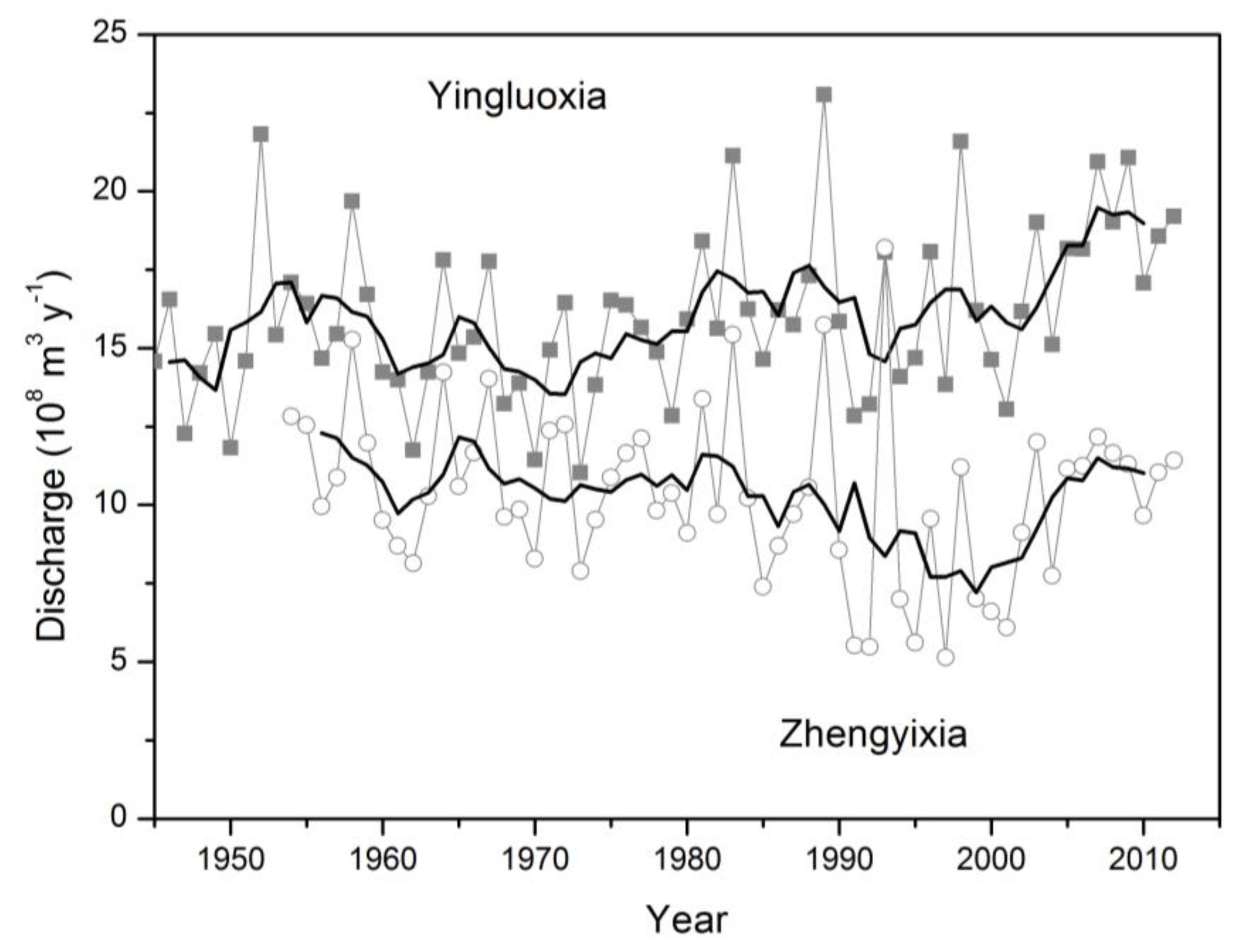
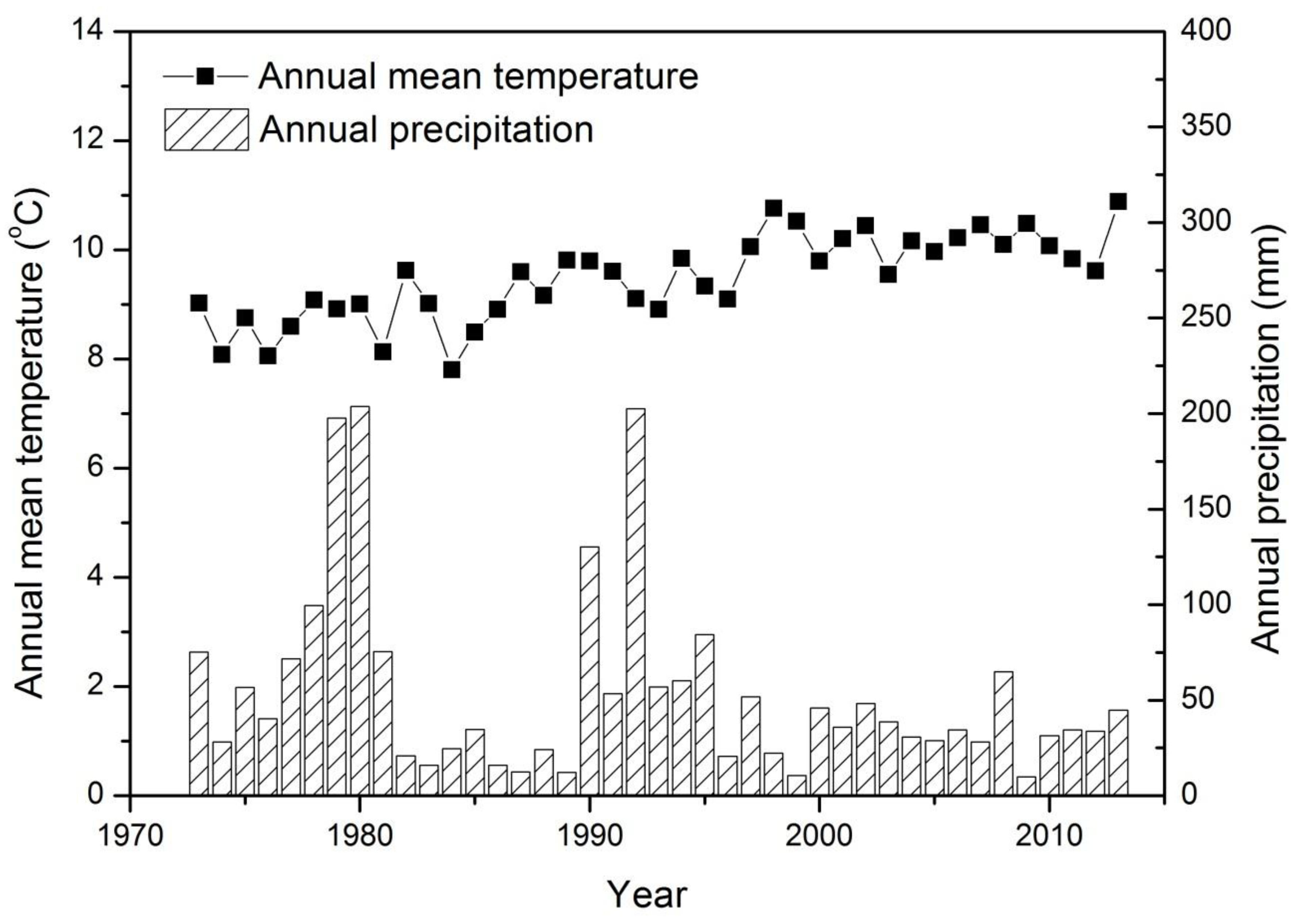
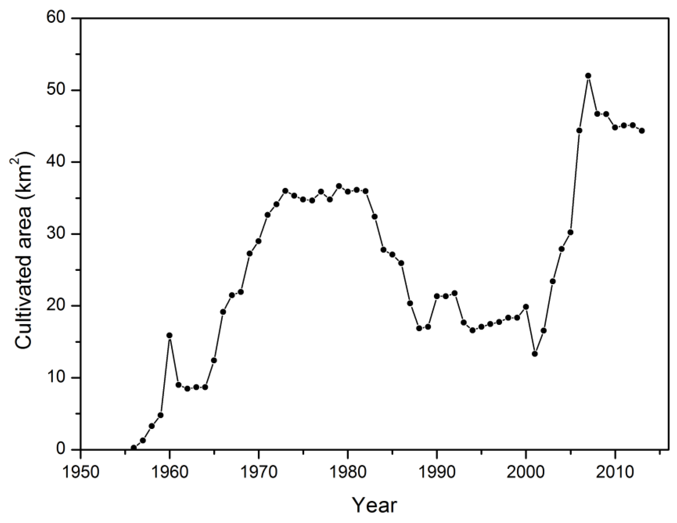
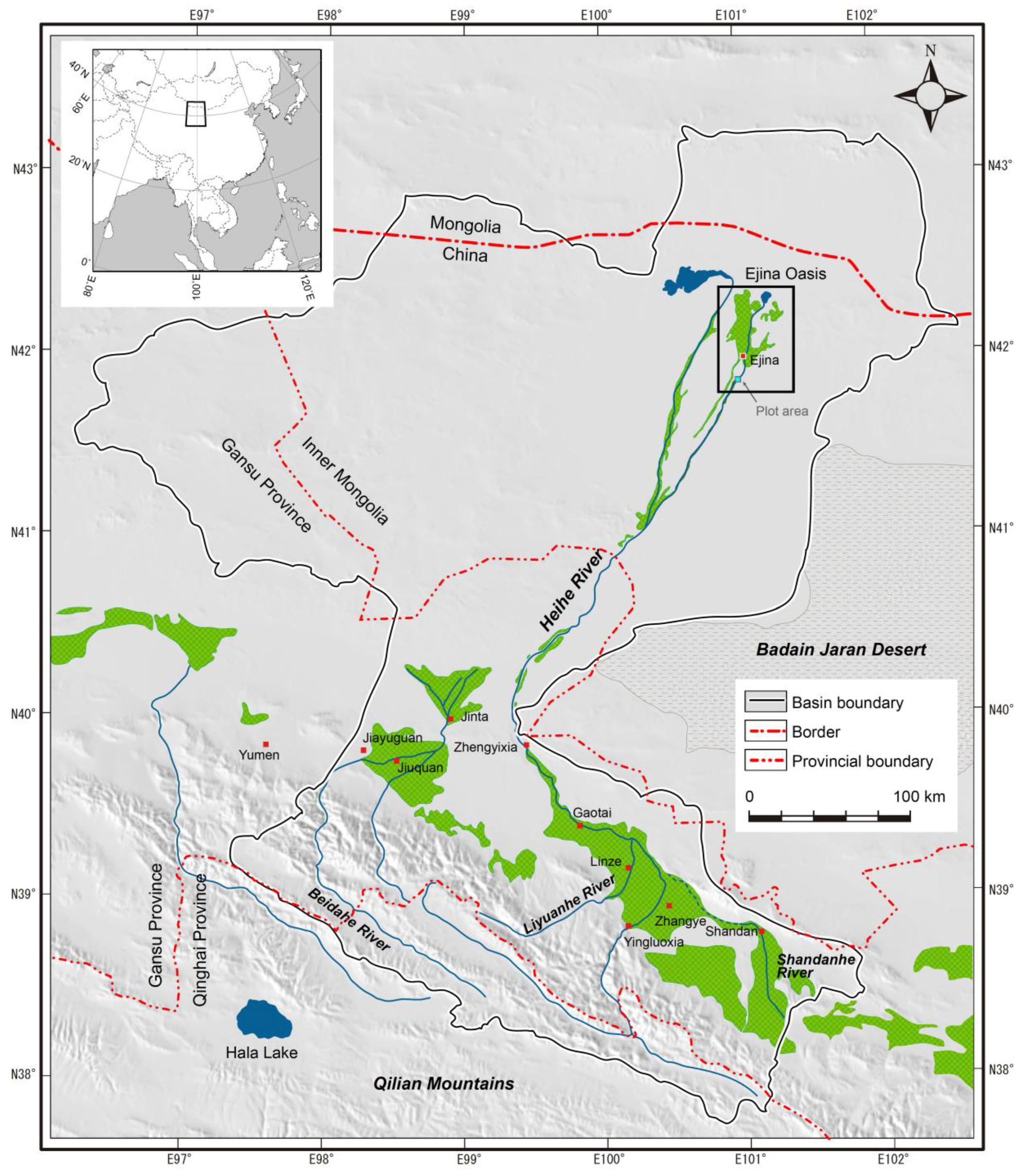
2. The Study Area
3. Material and Methods
3.1. Remote Sensing Data Analysis
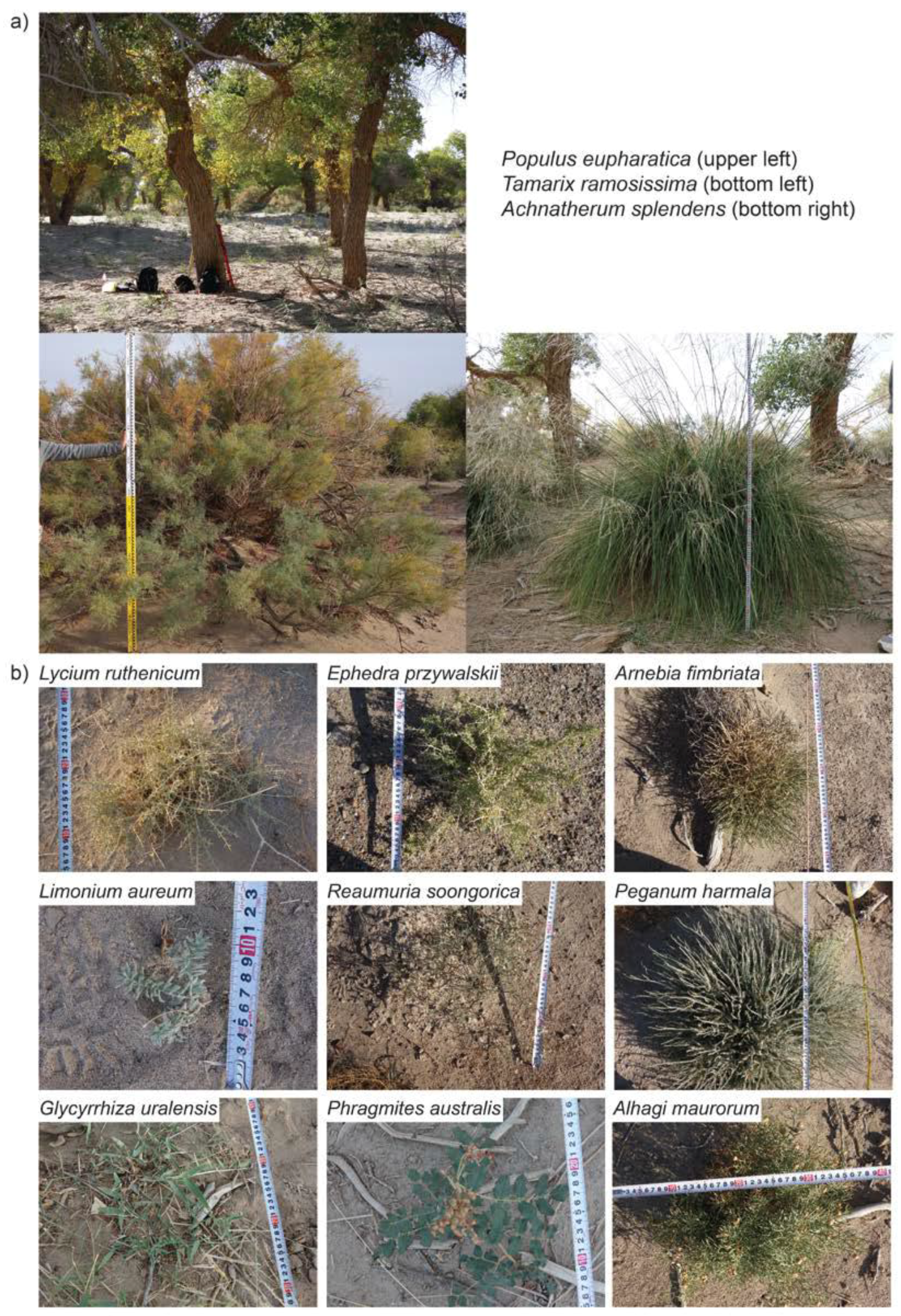
3.2. Plot Survey
3.3. Semi-Structured Questionnaire Survey
4. Results
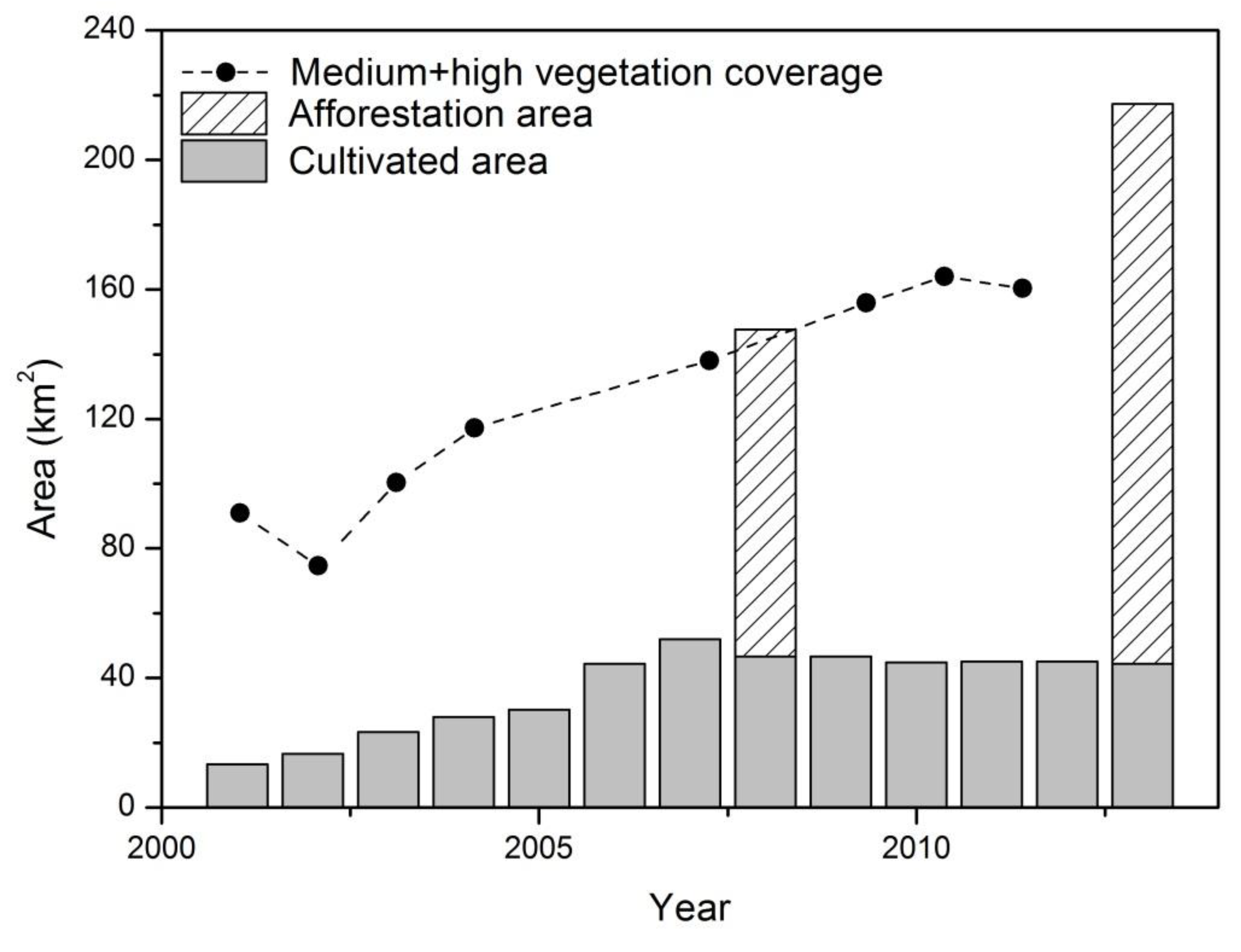
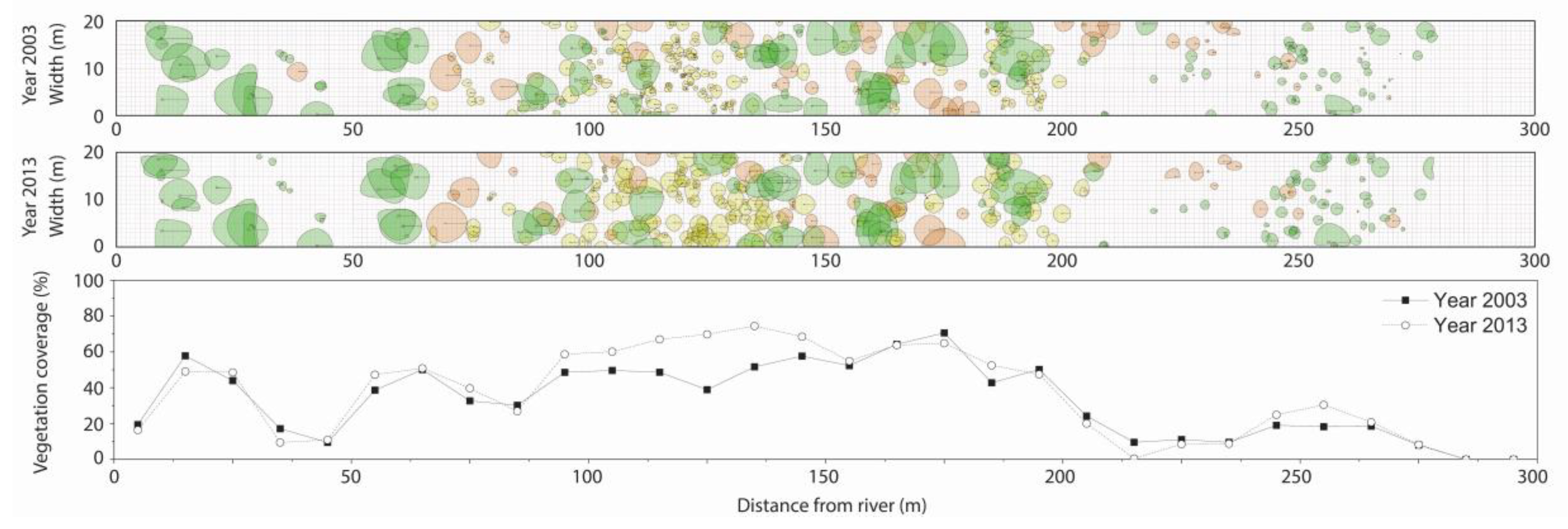
4.1. Vegetation Changes in the Lower Reaches of the Heihe River Basin
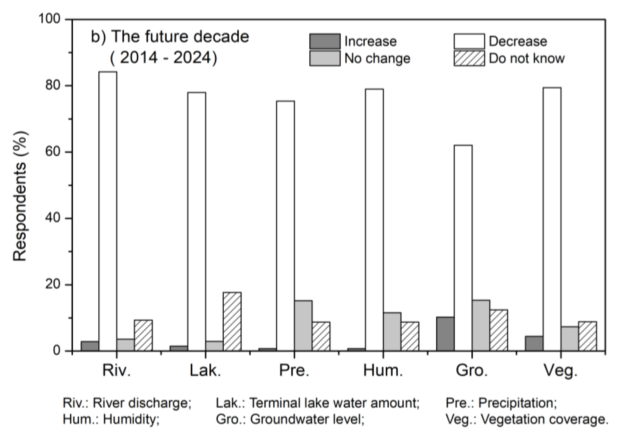
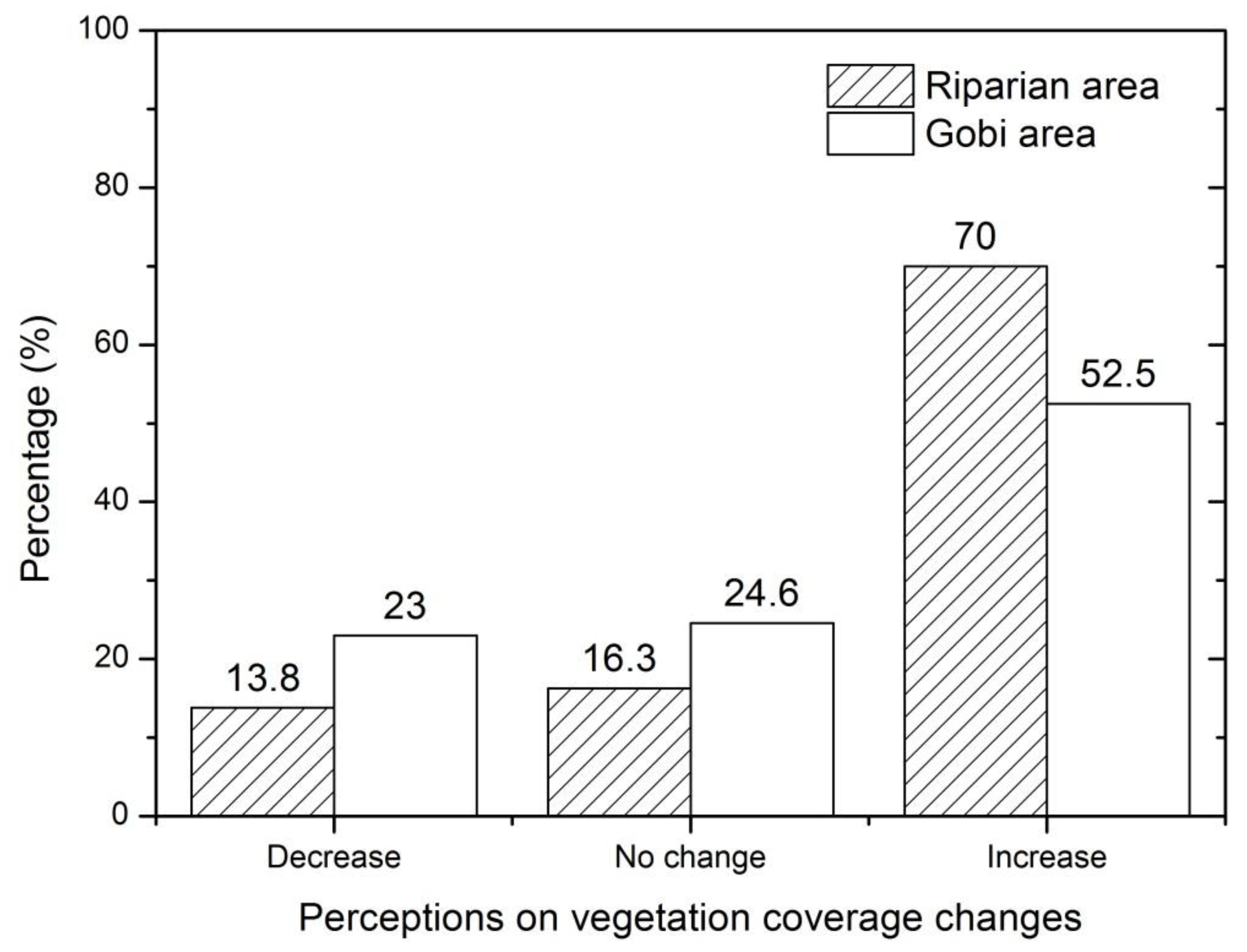
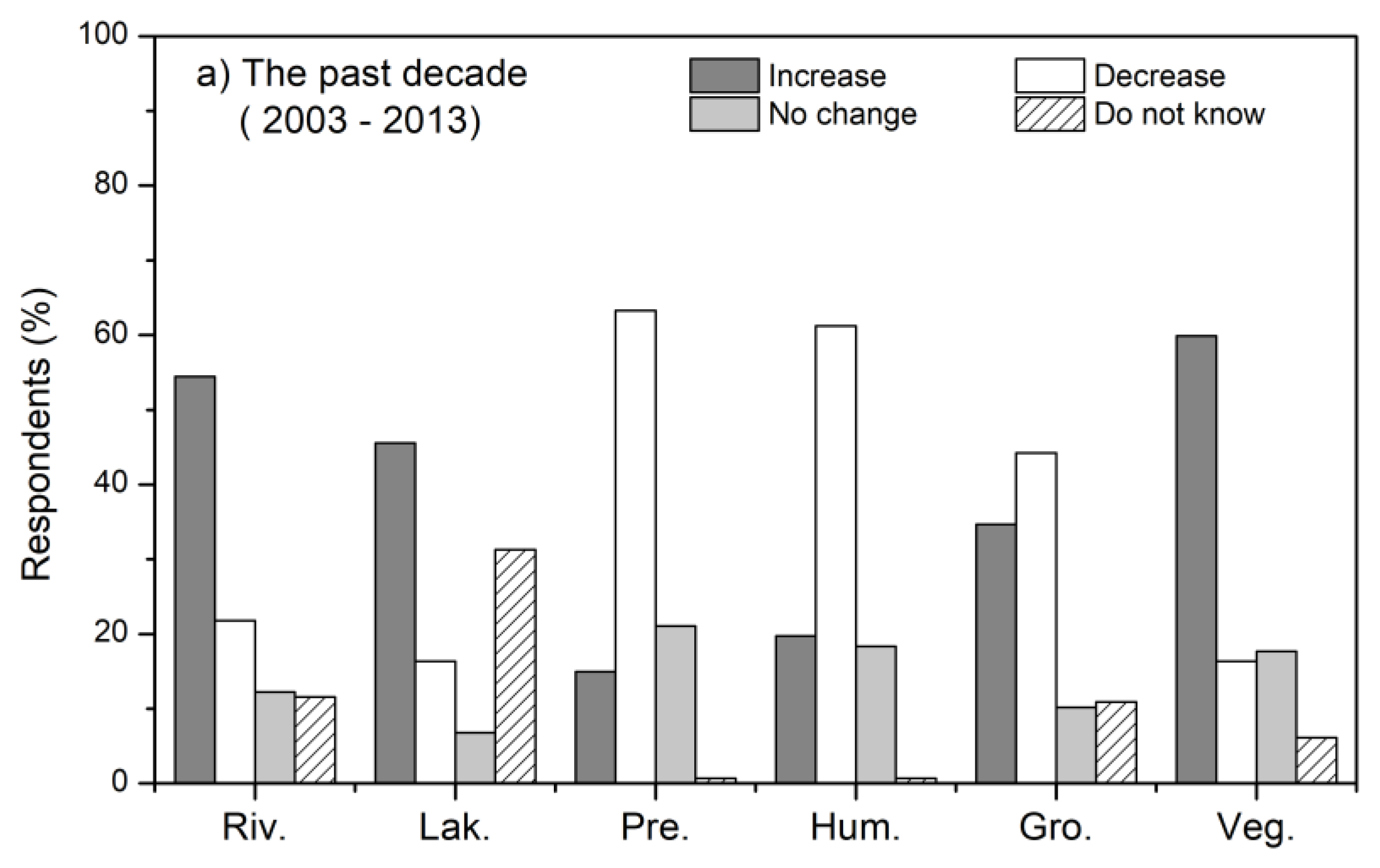
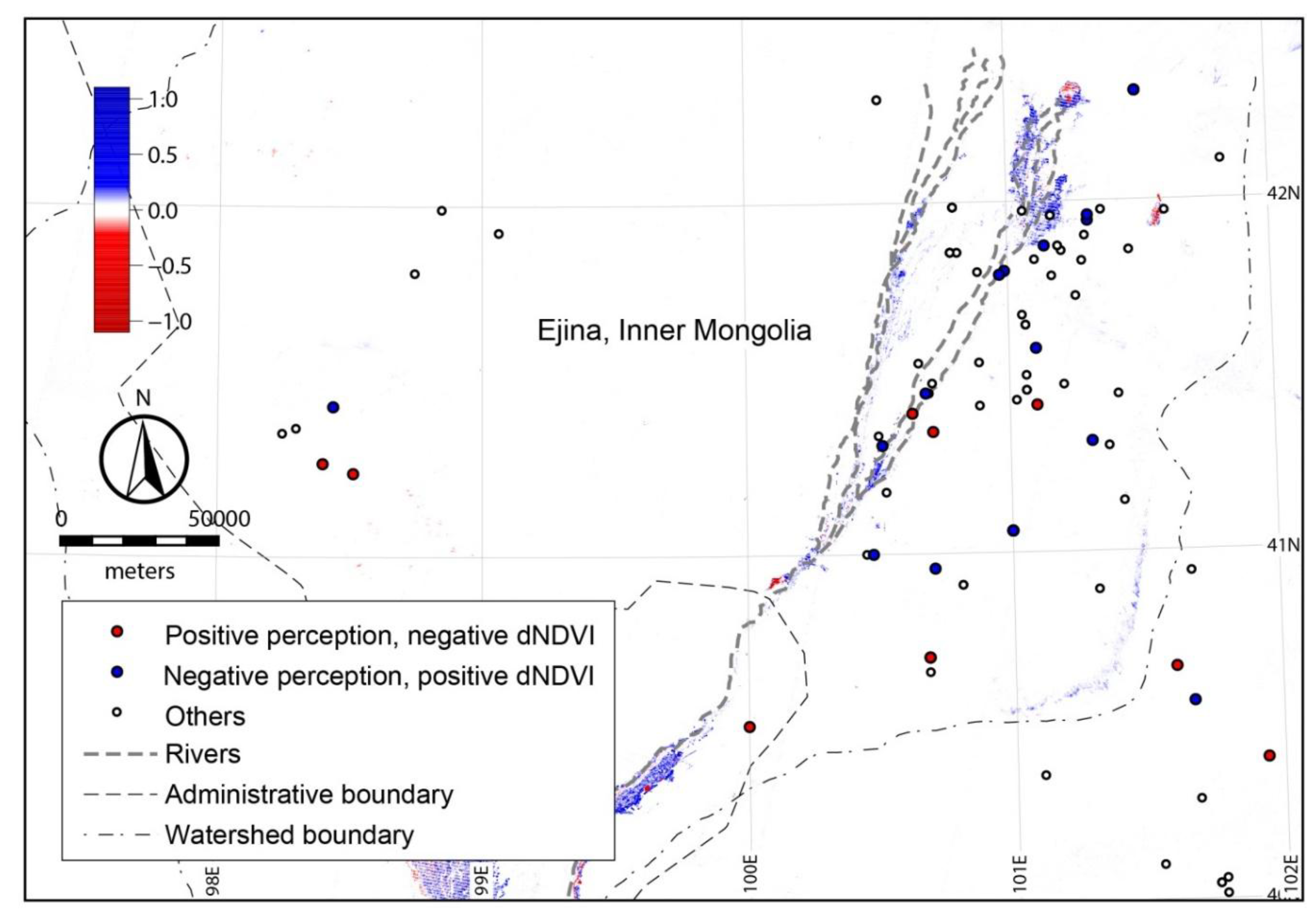
4.2. Residents’ Perceptions of Ecological Changes in the Lower Reaches of the Heihe River Basin
5. Discussion and Conclusions
5.1. Vegetation Increase and Vegetation Restoration
5.2. People’s Perceptions of the Environmental Changes
Author Contributions
Acknowledgments
Conflicts of Interest
Appendix A


| Lower Reaches Region | Ejina Oasis | ||||
|---|---|---|---|---|---|
| Path/Row | Acquisition Date | Sensor | Path/Row | ACQUISITION DATE | Sensor |
| 133/31 | 21 August 2001 | TM | 133/31 | 06 August 2007 | TM |
| 134/31 | 20 August 2001 | ETM+ | 133/31 | 11 August 2009 | TM |
| 135/31 | 19 August 2001 | TM | 134/31 | 12 August 2001 | TM |
| 133/32 | 21 August 2001 | TM | 134/31 | 15 August 2002 | TM |
| 134/32 | 20 August 2001 | ETM+ | 134/31 | 02 August 2003 | TM |
| 133/31 | 27 August 2012 | ETM+ | 134/31 | 20 August 2004 | TM |
| 134/31 | 18 August 2012 | ETM+ | 134/31 | 21 August 2010 | TM |
| 135/31 | 25 August 2012 | ETM+ | 134/31 | 08 August 2011 | TM |
| 133/32 | 27 August 2012 | ETM+ | |||
| 134/32 | 18 August 2012 | ETM+ | |||
References
- UNCCD. United Nations Convention to Combat Desertification in Countries Experiencing Serious Drought and/or Desertification, Particularly in Africa; A/AC.241/27; United Nations: Paris, France, 1994. [Google Scholar]
- UNCCD. Land and Soil in the Context of a Green Economy for Sustainable Development, Food Security, and Poverty Eradication: The Submission of the UNCCD Secretariat to the Preparatory Process for the Rio+20 Conference; UNCCD: Bonn, Germany, 2011. [Google Scholar]
- Lu, Q.; Wu, B. Disaster assessment and economic loss budget of desertification in China. Popul. Resour. Environ. China 2002, 12, 29–33. (In Chinese) [Google Scholar]
- He, Z.; Zhao, W. Characterizing the spatial structures of riparian plant communities in the lower reaches of the Heihe River in China using geostatistical techniques. Ecol. Res. 2006, 21, 551–559. [Google Scholar] [CrossRef]
- Wen, X.; Wu, Y.; Su, J.; Zhang, Y.; Liu, F. Hydrochemical characteristics and salinity of groundwater in the Ejina Basin, Northwestern China. Environ. Geol. 2005, 48, 665–675. [Google Scholar] [CrossRef]
- Guo, Q.; Feng, Q.; Li, J. Environmental changes after ecological water conveyance in the lower reaches of Heihe River, northwest china. Environ. Geol. 2009, 58, 1387–1396. [Google Scholar] [CrossRef]
- Ministry of Water Resources. Short-Term and Comprehensive Management Plan of Heihe River Basin; Ministry of Water Resources: Addis Ababa, Ethiopia, 2002.
- Wang, Y.; Feng, Q.; Chen, L.; Yu, T. Significance and effect of ecological rehabilitation project in inland river basins in Northwest China. Environ. Manag. 2013, 52, 209–220. [Google Scholar] [CrossRef] [PubMed]
- Zhong, J. Establishing green ecological barrier in Northwestern China Achievement of 30 years’ afforestation efforts in Ejina. J. Inn. Mong. For. 2008, 11, 12–13. (In Chinese) [Google Scholar]
- Wang, P.; Zhang, Y.; Yu, J.; Fu, G.; Ao, F. Vegetation dynamics induced by groundwater fluctuations in the lower Heihe River Basin, northwestern China. J. Plant Ecol. 2011, 4, 77–90. [Google Scholar] [CrossRef]
- Wang, P.; Yu, J.; Zhang, Y.; Fu, G.; Min, L.; Ao, F. Impacts of environmental flow controls on the water table and groundwater chemistry in the Ejina Delta, northwestern China. Environ. Earth Sci. 2011, 64, 15–24. [Google Scholar] [CrossRef]
- Si, J.; Feng, Q.; Zhang, X.; Su, Y.; Zhang, Y. Vegetation changes in the lower reaches of the Heihe River after its water import. Acta Bot. Boreal.-Occident. Sin. 2005, 25, 631–640. (In Chinese) [Google Scholar]
- Guo, Q.; Yang, Y.; Chen, Z. Remote sensing monitoring vegetation cover change in Ejina County after Heihe river water was distributed. J. Water Resour. Water Eng. 2010, 21, 65–71. (In Chinese) [Google Scholar]
- Cao, S.; Xu, C.; Chen, L.; Wang, X. Attitudes of farmers in China’s northern Shaanxi Province towards the land-use changes required under the Grain for Green Project, and implications for the project’s success. Land Use Policy 2009, 26, 1182–1194. [Google Scholar] [CrossRef]
- Karanth, K.K.; Nepal, S.K. Local residents perception of benefits and losses from protected areas in India and Nepal. Environ. Manag. 2012, 49, 372–386. [Google Scholar] [CrossRef] [PubMed]
- Maikhuri, R.K.; Nautiyal, S.; Rao, K.S.; Saxena, K.G. Conservation policy-people conflicts: A case study from Nanda Devi Biosphere Reserve (a World Heritage Site), India. For. Policy Econ. 2001, 2, 355–365. [Google Scholar] [CrossRef]
- Akiyama, T.; Li, J.; Kubota, J.; Konagaya, Y.; Watanabe, M. Perspectives on Sustainability Assessment: An Integral Approach to Historical Changes in Social Systems and Water Environment in the Ili River Basin of Central Eurasia, 1900–2008. World Future 2012, 68, 595–627. [Google Scholar] [CrossRef]
- Wang, Y.; Feng, Q. Study on the sustainability of ecological water transfer and rehabilitation project based on participant investigation. In Proceedings of the 2nd International Conference on Remote sensing, Environment and Transportation Engineering (RSETE), Nanjing, China, 1–3 June 2012; pp. 1–6. [Google Scholar]
- Jin, X.; Schaepman, M.; Clevers, J.; Su, Z.; Hu, G. Correlation between annual runoff in the Heihe River to the vegetation cover in the Ejina Oasis (China). Arid Land Res. Manag. 2010, 24, 31–41. [Google Scholar] [CrossRef]
- Wu, J. The effect of ecological management in the upper reaches of Heihe River. Acta Ecol. Sin. 2011, 31, 1–7. [Google Scholar] [CrossRef]
- Wang, G.; Cheng, G. Water resource development and its influence on the environment in arid areas of China—The case of the Hei River basin. J. Arid Environ. 1999, 43, 121–131. [Google Scholar]
- Kang, E. Hydrological Studies of the Heihe River Basin in the Northwest Arid Regions of China. Project Report on an Oasis-Region; Research Institute for Humanity and Nature: Kyoto, Japan, 2002. [Google Scholar]
- Akiyama, T. A Study on Groundwater Recharge System and Water Use in the Heihe River Basin in an Arid Region of China. Ph.D. Thesis, University of Tokyo, Tokyo, Japan, 2007. [Google Scholar]
- Feng, Q.; Cheng, G.D.; Endo, K.N. Towards sustainable development of the environmentally degraded River Heihe basin, China. Hydrol. Sci. J. 2001, 46, 647–658. [Google Scholar] [CrossRef]
- Bureau of Statistics. The 6th National Census of Population, Ejina Country; Ejina Country; National Bureau of Statistics: Beijing, China, 2012. (In Chinese) [Google Scholar]
- Si, J.; Feng, Q.; Xi, H.; Chang, Z.; Su, Y. Ejina Desert Oasis: A Fragile “Ecological Screen” in Inland Region of Northwest China. In Proceedings of the 2nd International Conference on Bioinformatics and Biomedical Engineering (ICBBE), Shanghai, China, 16–18 May 2008. [Google Scholar]
- Fabricante, I.; Oesterheld, M.; Paruelo, J.M. Annual and seasonal variation of NDVI explained by current and previous precipitation across Northern Patagonia. J. Arid Environ. 2009, 73, 745–753. [Google Scholar] [CrossRef]
- McGwire, K.; Minor, T.; Fenstermaker, L. Hyperspectral mixture modeling for quantifying sparse vegetation cover in arid environments. Remote Sens. Environ. 2000, 72, 360–374. [Google Scholar] [CrossRef]
- Zhang, Y.C.; Yu, J.J.; Wang, P.; Fu, G.B. Vegetation responses to integrated water management in the Ejina basin, northwest China. Hydrol. Process. 2011, 25, 3448–3461. [Google Scholar] [CrossRef]
- Chander, G.; Markham, B.L.; Helder, D.L. Summary of current radiometric calibration coefficients for Landsat MSS, TM, ETM+, and EO-1 ALI sensors. Remote Sens. Environ. 2009, 113, 893–903. [Google Scholar] [CrossRef]
- Chang, Y.; Bao, D.; Bao, Y. Satellite monitoring of the environment recovery effect in the Heihe River downstream region for the last 11 years. Proced. Environ. Sci. 2011, 10, 2385–2392. [Google Scholar] [CrossRef]
- Guoqian, W.; Xuequan, W.; Bo, W.; Qi, L. Desertification and Its Mitigation Strategy in China. J. Resour. Ecol. 2012, 3, 97–104. [Google Scholar] [CrossRef]
- Jin, X.M.; Schaepman, M.E.; Clevers, J.G.P.W.; Su, Z.B.; Hu, G.C. Groundwater depth and vegetation in the Ejina area, China. Arid Land Res. Manag. 2011, 25, 194–199. [Google Scholar] [CrossRef]
- Klintenberg, P.; Seely, M.; Christiansson, C. Local and national perceptions of environmental change in central Northern Namibia: Do they correspond? J. Arid Environ. 2007, 69, 506–525. [Google Scholar] [CrossRef]
- Lee, H.F.; Zhang, D.D. Perceiving desertification from the lay perspective in northern China. Land Degrad. Dev. 2004, 15, 529–542. [Google Scholar] [CrossRef]
- Lee, H.F.; Zhang, D.D. Perceiving land-degrading activities from the lay perspective in northern China. Environ. Manag. 2005, 36, 711–725. [Google Scholar] [CrossRef] [PubMed]
- Lee, H.F.; Zhang, D.D. Perceiving the environment from the lay perspective in desertified areas, northern China. Environ. Manag. 2008, 41, 168–182. [Google Scholar] [CrossRef] [PubMed]
- Ward, D.; Ngairorue, B.T.; Apollus, A.; Tjiveze, H. Perceptions and realities of land degradation in arid Otjimbingwe, Namibia. J. Arid Environ. 2000, 45, 337–356. [Google Scholar] [CrossRef]
- Wezel, A.; Haigis, J. Farmer’s perception of vegetation changes in semi-arid niger. Land Degrad. Dev. 2000, 11, 523–534. [Google Scholar] [CrossRef]
- Bureau of Forestry. Current Development Condition of Foresty Industry in Ejina; Ejina Country; Bureau of Forestry: Ejina, China, 2014. (In Chinese) [Google Scholar]
- Wang, Y.; Feng, Q.; Si, J.; Su, Y.; Chang, Z.; Xi, H. The changes of vegetation cover in Ejina Oasis based on water resources redistribution in Heihe River. Environ. Earth Sci. 2011, 64, 1965–1973. [Google Scholar] [CrossRef]
- Akiyama Sakai, A.; Yamazaki, Y.; Wang, G.; Fujita, K.; Nakawo, M.; Kubota, J.; Konagaya, Y.T. Surfacewater-groundwater interaction in the Heihe River basin, Northwestern China. Bull. Glaciol. Res. 2007, 24, 87–94. [Google Scholar]
- Cao, S. Why large-scale afforestation efforts in China have failed to solve the desertification problem. Environ. Sci. Technol. 2008, 42, 1826–1831. [Google Scholar] [CrossRef] [PubMed]
- Yang, H.; Lu, Q.; Wu, B.; Yang, H.; Zhang, J.; Lin, Y. Vegetation diversity and its application in sandy desert revegetation on Tibetan Plateau. J. Arid Environ. 2006, 65, 619–631. [Google Scholar] [CrossRef]


| NDVI | Grade | Description |
|---|---|---|
| <0.1 | No vegetation cover | Bare land sand (includes Gobi Desert areas) |
| 0.1–0.3 | Sparse vegetation cover | Semi-mobile sandy land, low-yield grassland, and uncultivated farmland |
| 0.3–0.6 | Medium vegetation cover | Shrub woodland, medium-yield grassland, fixed sandy land, and overflow land |
| >0.6 | High vegetation cover | Dense shrub land, forests, and high-quality arable land |
| dNDVI | Perception | Description |
|---|---|---|
| >0 | Increase | Actual changes in vegetation coverage and local residents’ responses are consistent (both improved). |
| <0 | Decrease | Actual changes in vegetation coverage and local residents’ responses are consistent (both decreased). |
| >0 | Decrease | Actual changes in vegetation coverage and local residents’ responses are not consistent. Actual vegetation coverage increased, while respondents’ perception is opposite. |
| <0 | Increase | Actual changes in vegetation coverage and local residents’ responses are not consistent. Actual vegetation coverage decreased, while respondents’ perception is opposite. |
© 2018 by the authors. Licensee MDPI, Basel, Switzerland. This article is an open access article distributed under the terms and conditions of the Creative Commons Attribution (CC BY) license (http://creativecommons.org/licenses/by/4.0/).
Share and Cite
Zhou, T.; Akiyama, T.; Horita, M.; Kharrazi, A.; Kraines, S.; Li, J.; Yoshikawa, K. The Impact of Ecological Restoration Projects in Dry Lands: Data-based Assessment and Human Perceptions in the Lower Reaches of Heihe River Basin, China. Sustainability 2018, 10, 1471. https://doi.org/10.3390/su10051471
Zhou T, Akiyama T, Horita M, Kharrazi A, Kraines S, Li J, Yoshikawa K. The Impact of Ecological Restoration Projects in Dry Lands: Data-based Assessment and Human Perceptions in the Lower Reaches of Heihe River Basin, China. Sustainability. 2018; 10(5):1471. https://doi.org/10.3390/su10051471
Chicago/Turabian StyleZhou, Tianyi, Tomohiro Akiyama, Masahide Horita, Ali Kharrazi, Steven Kraines, Jia Li, and Ken Yoshikawa. 2018. "The Impact of Ecological Restoration Projects in Dry Lands: Data-based Assessment and Human Perceptions in the Lower Reaches of Heihe River Basin, China" Sustainability 10, no. 5: 1471. https://doi.org/10.3390/su10051471
APA StyleZhou, T., Akiyama, T., Horita, M., Kharrazi, A., Kraines, S., Li, J., & Yoshikawa, K. (2018). The Impact of Ecological Restoration Projects in Dry Lands: Data-based Assessment and Human Perceptions in the Lower Reaches of Heihe River Basin, China. Sustainability, 10(5), 1471. https://doi.org/10.3390/su10051471