Land Cover Based Landscape Pattern Dynamics of Anhui Province Using GlobCover and MCD12Q1 Global Land Cover Products

Abstract
:1. Introduction
2. Materials and Methods
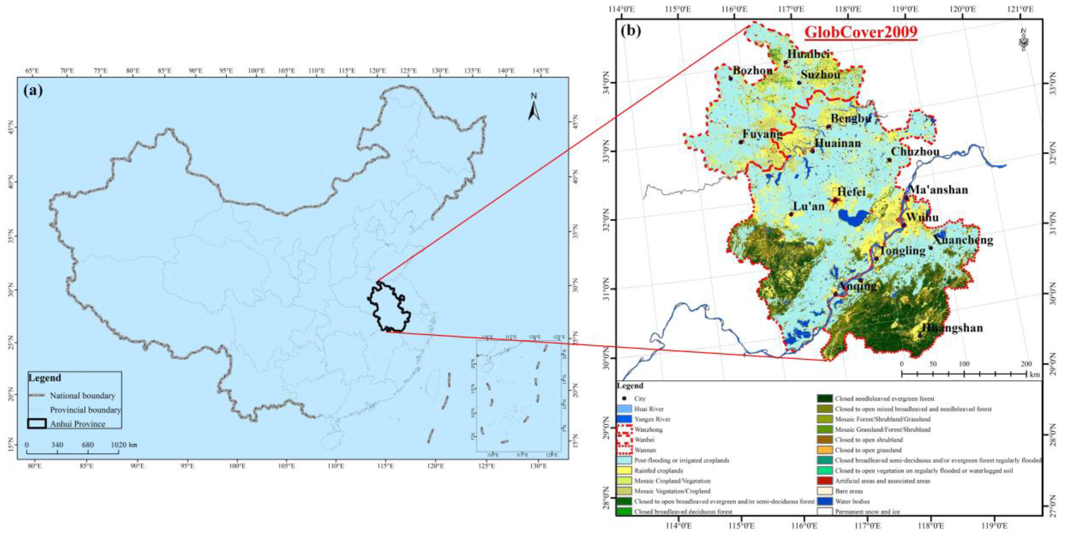
2.1. Study Area
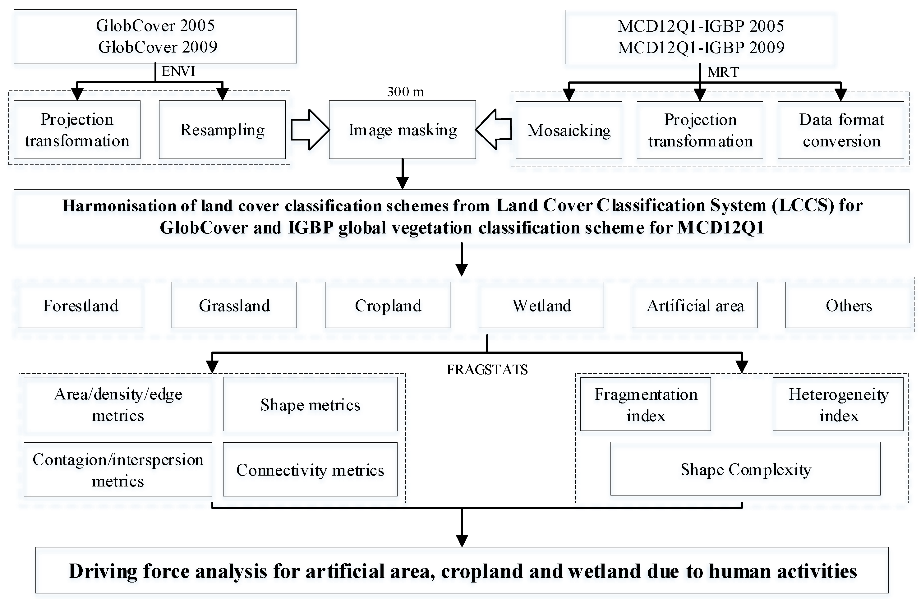
2.2. Technical Route
2.3. Data Sources and Preprocessing
2.3.1. MCD12Q1 Products and Pre-Treatment
2.3.2. GlobCover Products and Pre-Treatment
2.3.3. Harmonization of LCCSs
2.4. Selection of Landscape Metrics at Both the Class and Landscape Scale
4. Results and Discussion
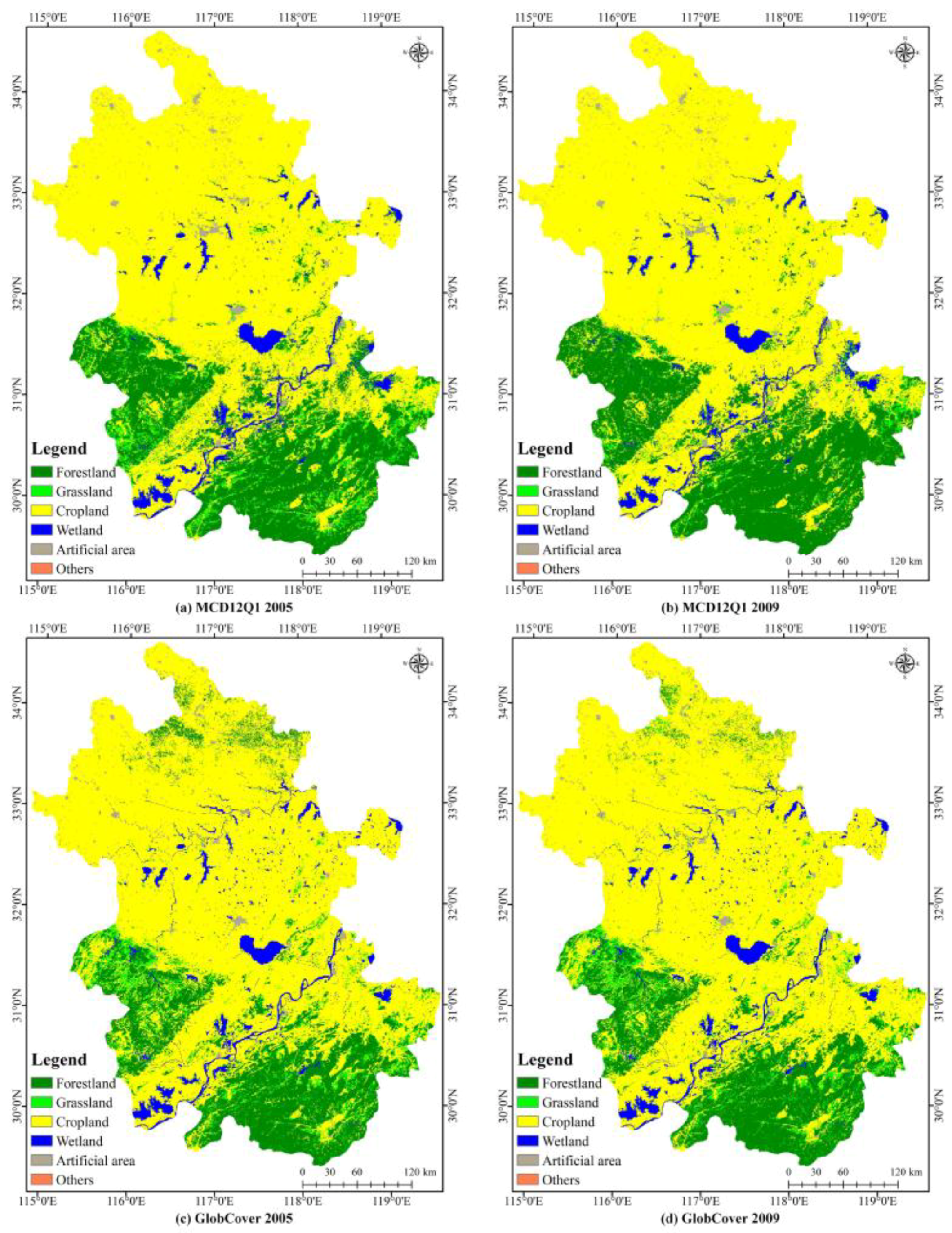
4.1. Reclassified Land Cover Maps Derived from MCD 12Q1 and GlobCover
4.2. Analysis of Landscape Pattern Change
4.2.1. Comparison of CA, NP, and PD
4.2.2. Comparison of ED, LSI, and PAFRAC
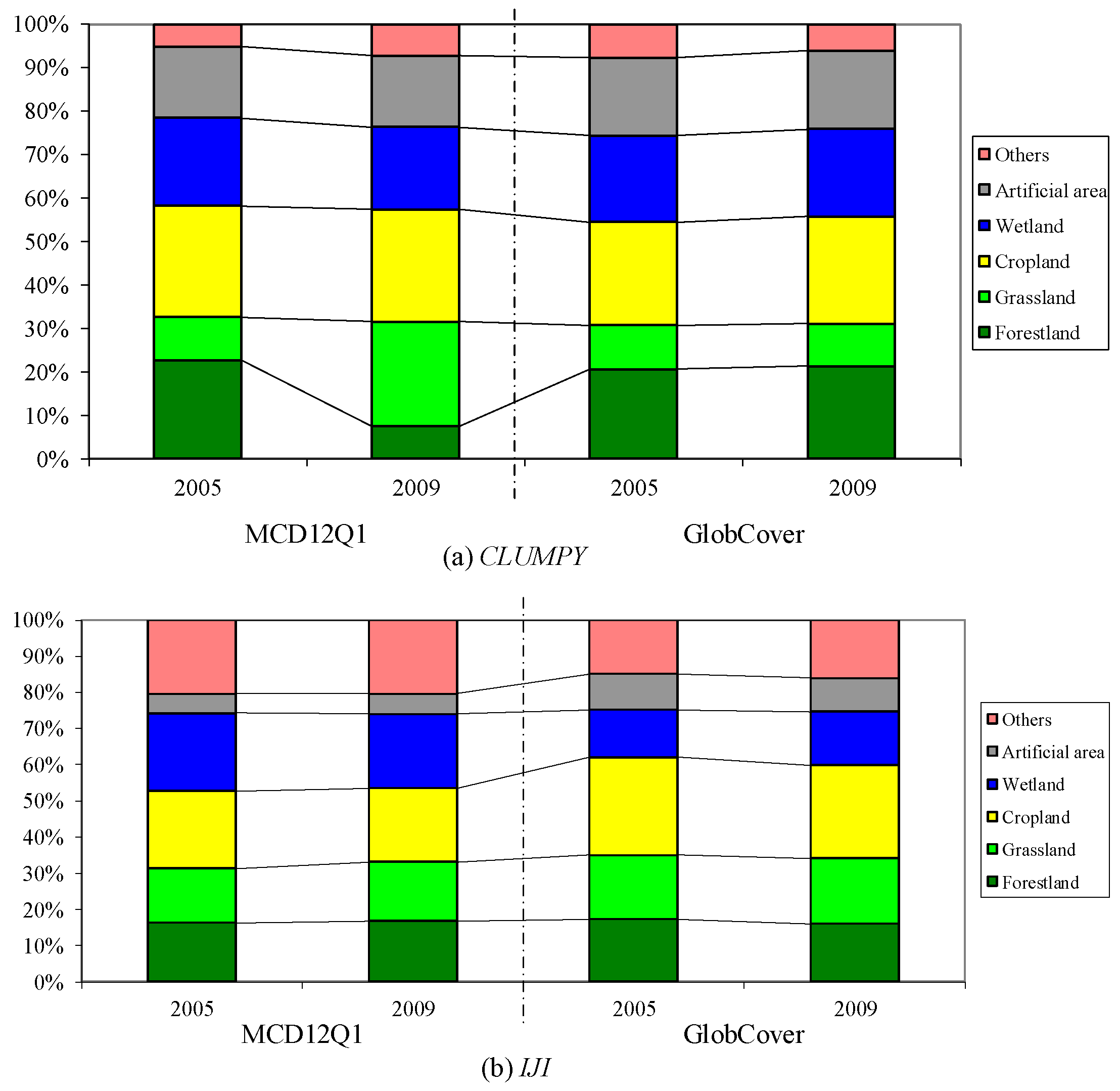
4.2.3. Comparison of Aggregation
4.2.4. Connectivity Comparison
4.2.5. Analysis of Spatial Landscape Pattern
4.3. Driving Force Analysis
5. Conclusions
Author Contributions
Acknowledgments
Conflicts of Interest
References
- Turner, M.G.; O’Neill, R.V.; Gardner, R.H.; Milne, B.T. Effects of changing spatial scale on the analysis of landscape pattern. Landsc. Ecol. 1989, 3, 153–162. [Google Scholar] [CrossRef]
- Turner, M.G. Landscape ecology: The effect of pattern on process. Annu. Rev. Ecol. Syst. 1989, 20, 171–197. [Google Scholar] [CrossRef]
- Pickett, S.T.; Cadenasso, M.L. Landscape ecology: Spatial heterogeneity in ecological systems. Science 1995, 269, 331. [Google Scholar] [CrossRef] [PubMed]
- Teixidó, N.; Garrabou, J.; Arntz, W.E. Spatial pattern quantification of Antarctic benthic communities using landscape indices. Mar. Ecol. Prog. Ser. 2002, 242, 1–14. [Google Scholar] [CrossRef]
- Hamstead, Z.A.; Kremer, P.; Larondelle, N.; McPhearson, T.; Haase, D. Classification of the heterogeneous structure of urban landscapes (STURLA) as an indicator of landscape function applied to surface temperature in New York City. Ecol. Indic. 2016, 70, 574–585. [Google Scholar] [CrossRef]
- Opdam, P.; Steingröver, E.; Van Rooij, S. Ecological networks: A spatial concept for multi-actor planning of sustainable landscapes. Landsc. Urban Plan. 2006, 75, 322–332. [Google Scholar] [CrossRef]
- Kerr, J.T.; Ostrovsky, M. From space to species: Ecological applications for remote sensing. Trends Ecol. Evol. 2003, 18, 299–305. [Google Scholar] [CrossRef]
- Fagerholm, N.; Oteros-Rozas, E.; Raymond, C.M.; Torralba, M.; Moreno, G.; Plieninger, T. Assessing linkages between ecosystem services, land-use and well-being in an agroforestry landscape using public participation GIS. Appl. Geogr. 2016, 74, 30–46. [Google Scholar] [CrossRef]
- Fernández, P.; Rodríguez, A.; Obregón, R.; de Haro, S.; Jordano, D.; Fernández-Haeger, J. Fine scale movements of the butterfly Plebejus argus in a heterogeneous natural landscape as revealed by GPS tracking. J. Insect Behav. 2016, 29, 80–98. [Google Scholar] [CrossRef]
- Balthazar, V.; Vanacker, V.; Molina, A.; Lambin, E.F. Impacts of forest cover change on ecosystem services in high Andean mountains. Ecol. Indic. 2015, 48, 63–75. [Google Scholar] [CrossRef]
- Vogelmann, J.E.; Helder, D.; Morfitt, R.; Choate, M.J.; Merchant, J.W.; Bulley, H. Effects of Landsat 5 Thematic Mapper and Landsat 7 Enhanced Thematic Mapper Plus radiometric and geometric calibrations and corrections on landscape characterization. Remote Sens. Environ. 2001, 78, 55–70. [Google Scholar] [CrossRef]
- Fichera, C.R.; Modica, G.; Pollino, M. Land Cover classification and change-detection analysis using multi-temporal remote sensed imagery and landscape metrics. Eur. J. Remote Sens. 2012, 45, 1–18. [Google Scholar] [CrossRef]
- Li, J.; Song, C.; Cao, L.; Zhu, F.; Meng, X.; Wu, J. Impacts of landscape structure on surface urban heat islands: A case study of Shanghai, China. Remote Sens. Environ. 2011, 115, 3249–3263. [Google Scholar] [CrossRef]
- Qian, Y.; Zhou, W.; Yu, W.; Pickett, S.T. Quantifying spatiotemporal pattern of urban greenspace: New insights from high resolution data. Landsc. Ecol. 2015, 30, 1165–1173. [Google Scholar] [CrossRef]
- Del Castillo, E.M.; García-Martin, A.; Aladrén, L.A.L.; de Luis, M. Evaluation of forest cover change using remote sensing techniques and landscape metrics in Moncayo Natural Park (Spain). Appl. Geogr. 2015, 62, 247–255. [Google Scholar] [CrossRef]
- Herold, M.; Scepan, J.; Clarke, K.C. The use of remote sensing and landscape metrics to describe structures and changes in urban land uses. Environ. Plan. A 2002, 34, 1443–1458. [Google Scholar] [CrossRef]
- Shao, G.; Wu, J. On the accuracy of landscape pattern analysis using remote sensing data. Landsc. Ecol. 2008, 23, 505–511. [Google Scholar]
- Banerjee, R.; Srivastava, P.K. Reconstruction of contested landscape: Detecting land cover transformation hosting cultural heritage sites from Central India using remote sensing. Land Use Policy 2013, 34, 193–203. [Google Scholar] [CrossRef]
- García-Llamas, P.; Calvo, L.; Álvarez-Martínez, J.M.; Suárez-Seoane, S. Using remote sensing products to classify landscape. A multi-spatial resolution approach. Int. J. Appl. Earth Obs. 2016, 50, 95–105. [Google Scholar] [CrossRef]
- Reger, B.; Otte, A.; Waldhardt, R. Identifying patterns of land-cover change and their physical attributes in a marginal European landscape. Landsc. Urban Plan. 2007, 81, 104–113. [Google Scholar] [CrossRef]
- Loveland, T.R.; Belward, A.S. The international geosphere biosphere programme data and information system global land cover data set (DISCover). Acta Astronaut. 1997, 41, 681–689. [Google Scholar] [CrossRef]
- Hansen, M.C.; DeFries, R.S.; Townshend, J.R.G.; Sohlberg, R. Global land cover classification at 1 km spatial resolution using a classification tree approach. Int. J. Remote Sens. 2000, 21, 1331–1364. [Google Scholar] [CrossRef]
- Friedl, M.A.; Sulla-Menashe, D.; Tan, B.; Schneider, A.; Ramankutty, N.; Sibley, A.; Huang, X. MODIS Collection 5 global land cover: Algorithm refinements and characterization of new datasets. Remote Sens. Environ. 2010, 114, 168–182. [Google Scholar] [CrossRef]
- Bartholomé, E.; Belward, A.S. GLC2000: A new approach to global land cover mapping from Earth observation data. Int. J. Remote Sens. 2005, 26, 1959–1977. [Google Scholar] [CrossRef]
- Defourny, P.; Vancutsem, C.; Bicheron, P.; Brockmann, C.; Nino, F.; Schouten, L.; Leroy, M. GLOBCOVER: A 300 m global land cover product for 2005 using Envisat MERIS time series. In Proceedings of the ISPRS Commission VII Mid-Term Symposium, Remote Sensing: From Pixels to Processes, Enschede, The Netherlands, 8–11 May 2006. [Google Scholar]
- Chen, J.; Chen, J.; Liao, A.; Cao, X.; Chen, L.; Chen, X.; He, C.; Han, G.; Peng, S.; Lu, M.; Zhang, W.; Tong, X.; Mills, J. Global land cover mapping at 30 m resolution: A POK-based operational approach. ISPRS J. Photogramm. Remote Sens. 2015, 103, 7–27. [Google Scholar] [CrossRef]
- Kupfer, J.A. Rethinking landscape metrics in a post-FRAGSTATS landscape. Prog. Phys. Geogr. 2012, 36, 400–420. [Google Scholar] [CrossRef]
- Cushman, S.A.; McGarigal, K.; Neel, M.C. Parsimony in landscape metrics: Strength, universality, and consistency. Ecol. Indic. 2008, 8, 691–703. [Google Scholar] [CrossRef]
- Ji, W.; Ma, J.; Twibell, R.W.; Underhill, K. Characterizing urban sprawl using multi-stage remote sensing images and landscape metrics. Comput. Environ. Urban 2006, 30, 861–879. [Google Scholar] [CrossRef]
- Gillanders, S.N.; Coops, N.C.; Wulder, M.A.; Gergel, S.E.; Nelson, T. Multitemporal remote sensing of landscape dynamics and pattern change: Describing natural and anthropogenic trends. Prog. Phys. Geog. 2008, 32, 503–528. [Google Scholar] [CrossRef]
- Zhang, S.; Fan, W.; Li, Y.; Yi, Y. The influence of changes in land use and landscape patterns on soil erosion in a watershed. Sci. Total Environ. 2017, 574, 34–45. [Google Scholar] [CrossRef] [PubMed]
- Liang, D.; Zuo, Y.; Huang, L.S.; Zhao, J.L.; Teng, L.; Yang, F. Evaluation of the consistency of MODIS land cover product (MCD12Q1) based on Chinese 30 m GlobeLand30 datasets: A case study in Anhui Province, China. ISPRS Int. J. Geo-Inf. 2015, 4, 2519–2541. [Google Scholar] [CrossRef]
- Ahmad, A.; Brown, G. Random projection random discretization ensembles—Ensembles of linear multivariate decision trees. IEEE Trans. Knowl. Data Eng. 2014, 26, 1225–1239. [Google Scholar] [CrossRef]
- O’Neill, R.V.; Riitters, K.H.; Wickham, J.D.; Jones, K.B. Landscape pattern metrics and regional assessment. Ecosyst. Health 1999, 5, 225–233. [Google Scholar] [CrossRef]
- Tischendorf, L.; Fahrig, L. How should we measure landscape connectivity? Landsc. Ecol. 2000, 15, 633–641. [Google Scholar] [CrossRef]
- Jaeger, J.A. Landscape division, splitting index, and effective mesh size: New measures of landscape fragmentation. Landsc. Ecol. 2000, 15, 115–130. [Google Scholar] [CrossRef]
- Rutledge, D. Landscape Indices as Measures of the Effects of Fragmentation: Can Pattern Reflect Process? Department of Conservation: Wellington, New Zealand, 2003; pp. 5–27. [Google Scholar]
- McGarigal, K.; Cushman, S.A.; Ene, E. FRAGSTATS v4: Spatial Pattern Analysis Program for Categorical and Continuous Maps. Available online: http://www.umass.edu/landeco/research/fragstats/fragstats.html (accessed on 22 March 2018).
- Wu, J. Effects of changing scale on landscape pattern analysis: Scaling relations. Landsc. Ecol. 2004, 19, 125–138. [Google Scholar] [CrossRef]
- Patton, D.R. A diversity index for quantifying habitat “edge”. Wildl. Soc. Bull. 1975, 3, 171–173. [Google Scholar]
- Ramachandra, T.V.; Aithal, B.H.; Sanna, D.D. Insights to urban dynamics through landscape spatial pattern analysis. Int. J. Appl. Earth Obs. 2012, 18, 329–343. [Google Scholar]
- Neel, M.C.; McGarigal, K.; Cushman, S.A. Behavior of class-level landscape metrics across gradients of class aggregation and area. Landsc. Ecol. 2004, 19, 435–455. [Google Scholar] [CrossRef]
- Lausch, A.; Herzog, F. Applicability of landscape metrics for the monitoring of landscape change: Issues of scale, resolution and interpretability. Ecol. Indic. 2002, 2, 3–15. [Google Scholar]
- Gustafson, E.J. Quantifying landscape spatial pattern: What is the state of the art. Ecosystems 1998, 1, 143–156. [Google Scholar] [CrossRef]
- Crews-Meyer, K.A. Agricultural landscape change and stability in northeast Thailand: Historical patch-level analysis. Agric. Ecosyst. Environ. 2004, 101, 155–169. [Google Scholar] [CrossRef]
- Shaker, R.R. The well-being of nations: An empirical assessment of sustainable urbanization for Europe. Int. J. Sust. Dev. World 2015, 22, 375–387. [Google Scholar] [CrossRef]
- Eiter, S.; Potthoff, K. Landscape changes in Norwegian mountains: Increased and decreased accessibility, and their driving forces. Land Use Policy 2016, 54, 235–245. [Google Scholar] [CrossRef]
- Gergel, S.E.; Turner, M.G.; Miller, J.R.; Melack, J.M.; Stanley, E.H. Landscape indicators of human impacts to riverine systems. Aquat. Sci. 2002, 64, 118–128. [Google Scholar] [CrossRef]
- Alberti, M.; Marzluff, J.M.; Shulenberger, E.; Bradley, G.; Ryan, C.; Zumbrunnen, C. Integrating humans into ecology: Opportunities and challenges for studying urban ecosystems. AIBS Bull. 2003, 53, 1169–1179. [Google Scholar] [CrossRef]
- Li, W.; Cao, Q.; Lang, K.; Wu, J. Linking potential heat source and sink to urban heat island: Heterogeneous effects of landscape pattern on land surface temperature. Sci. Total Environ. 2017, 586, 457–465. [Google Scholar] [CrossRef] [PubMed]
- Shaker, R.R. Examining sustainable landscape function across the Republic of Moldova. Habitat Int. 2018, 72, 77–91. [Google Scholar] [CrossRef]


| MCD12Q1 | GlobCover | |
|---|---|---|
| Sensor | MODIS Terra+Aqua | ENVISAT MERIS |
| Collection date | January 2001/2013–December 2001/2013 | December 2004–June 2006 |
| Spatial resolution | 500 m | 300 m |
| Input data | Terra- and Aqua-MODIS data | 13 Spectral bands and NDVI composites |
| Method | Supervised decision-tree classification method | Per-pixel supervised (urban and wetland) and unsupervised classification |
| Validation method | Statistical validation | Statistical validation |
| Total accuracy | 74.8% | 73% |
| Land Cover Type | GlobCover | MCD12Q1 |
|---|---|---|
| Forestland | 1. Closed to open broadleaved evergreen and/or semi-deciduous forest | 1. Evergreen needleleaf forest |
| 2. Closed broadleaved deciduous forest | 2. Evergreen broadleaf forest | |
| 3. Closed needleleaved evergreen forest | 3. Deciduous needleleaf forest | |
| 4. Closed to open mixed broadleaved and needleleaved forest | 4. Deciduous broadleaf forest | |
| 5. Mosaic forest/shrubland/grassland | 5. Mixed forests | |
| 6. Closed broadleaved semi-deciduous and/or evergreen forest regularly flooded | 6. Closed shrublands | |
| 7. Closed to open shrubland | 7. Open shrublands | |
| Grassland | 1. Mosaic grassland/forest/shrubland | 1. Woody savannas |
| 2. Closed to open grassland | 2. Savannas | |
| 3. Grasslands | ||
| Cropland | 1. Post-flooding or irrigated croplands | 1. Croplands |
| 2. Rainfed croplands | 2. Cropland—natural vegetation mosaic | |
| 3. Mosaic cropland/vegetation | ||
| 4. Mosaic vegetation/cropland | ||
| Wetland | 1. Closed to open vegetation on regularly flooded or waterlogged soil | 1. Water bodies |
| 2. Water bodies | 2. Permanent wetlands | |
| 3. Permanent snow and ice | 3. Snow and ice | |
| Artificial area | 1. Artificial areas and associated areas | 1. Urban areas |
| Others | 1. Bare areas | 1. Barren or sparsely vegetated |
| Landscape Metrics | Metric | Acronym |
|---|---|---|
| Area/density/edge metrics | Class area | CA |
| Area/density/edge metrics | Number of patches | NP |
| Area/density/edge metrics | Patch density | PD |
| Area/density/edge metrics | Edge density | ED |
| Area/density/edge metrics | Landscape shape index | LSI |
| Shape metrics | Perimeter-area fractal dimension index | PAFRAC |
| Contagion/interspersion metrics | Clumpiness index | CLUMPY |
| Contagion/interspersion metrics | Interspersion and juxtaposition index | IJI |
| Connectivity metrics | Patch cohesion index | COHESION |
| Fragmentation | Fragmentation index | F |
| Heterogeneity | Heterogeneity index | HT |
| Shape Complexity | Mean patch fractal dimension | MPFD |
| Land Cover Type | Dataset | CA (km2) | NP (Account) | PD (Per km2) | |||
|---|---|---|---|---|---|---|---|
| 2005 | 2009 | 2005 | 2009 | 2005 | 2009 | ||
| Forestland | MCD12Q1 | 32,202.25 | 34,658.00 | 3753 | 3099 | 1.45 | 2.41 |
| GlobCover | 26,370.50 | 25,068.75 | 3257 | 3443 | 1.21 | 1.28 | |
| Grassland | MCD12Q1 | 7643.75 | 3995.50 | 7359 | 6262 | 2.83 | 1.19 |
| GlobCover | 6788.75 | 6985.75 | 6135 | 7025 | 2.29 | 2.62 | |
| Cropland | MCD12Q1 | 93,398.25 | 94,844.25 | 2482 | 2457 | 0.96 | 0.95 |
| GlobCover | 100,106.75 | 101,400.50 | 2252 | 2061 | 0.84 | 0.77 | |
| Wetland | MCD12Q1 | 4943.50 | 4630.50 | 1684 | 1809 | 0.65 | 0.70 |
| GlobCover | 5510.75 | 5318.75 | 1527 | 1589 | 0.57 | 0.59 | |
| Artificial area | MCD12Q1 | 2090.25 | 2090.25 | 1221 | 1221 | 0.47 | 0.47 |
| GlobCover | 1835.00 | 1795.75 | 861 | 866 | 0.32 | 0.32 | |
| Others | MCD12Q1 | 388.00 | 447.50 | 834 | 718 | 0.32 | 0.28 |
| GlobCover | 14.75 | 57.00 | 30 | 122 | 0.01 | 0.05 | |
| Land Use Type | Dataset | Fi | |
|---|---|---|---|
| 2005 | 2009 | ||
| Forestland | MCD12Q1 | 0.1601 | 0.2671 |
| GlobCover | 0.1390 | 0.1469 | |
| Grassland | MCD12Q1 | 0.3139 | 0.1322 |
| GlobCover | 0.2618 | 0.2997 | |
| Cropland | MCD12Q1 | 0.1059 | 0.1048 |
| GlobCover | 0.0961 | 0.0879 | |
| Wetland | MCD12Q1 | 0.0718 | 0.0772 |
| GlobCover | 0.0652 | 0.0678 | |
| Artificial area | MCD12Q1 | 0.0521 | 0.0521 |
| GlobCover | 0.0367 | 0.0369 | |
| Others | MCD12Q1 | 0.0356 | 0.0306 |
| GlobCover | 0.0013 | 0.0052 | |
| Land Cover Type | Dataset | ED (m/km2) | LSI | PAFRAC | |||
|---|---|---|---|---|---|---|---|
| 2005 | 2009 | 2005 | 2009 | 2005 | 2009 | ||
| Forestland | MCD12Q1 | 174.84 | 89.72 | 64.5933 | 92.5138 | 1.5381 | 1.6042 |
| GlobCover | 168.26 | 154.00 | 70.7938 | 66.4795 | 1.5321 | 1.5228 | |
| Grassland | MCD12Q1 | 149.30 | 139.21 | 111.3514 | 49.9141 | 1.6202 | 1.5429 |
| GlobCover | 123.65 | 130.26 | 101.0030 | 104.8776 | 1.5904 | 1.5848 | |
| Cropland | MCD12Q1 | 181.98 | 164.39 | 40.2682 | 36.3044 | 1.5147 | 1.5116 |
| GlobCover | 215.86 | 193.10 | 47.3705 | 42.2951 | 1.5393 | 1.5280 | |
| Wetland | MCD12Q1 | 43.61 | 46.79 | 40.6348 | 44.9817 | 1.5004 | 1.5116 |
| GlobCover | 42.55 | 42.14 | 38.9788 | 39.2500 | 1.4453 | 1.4555 | |
| Artificial area | MCD12Q1 | 27.32 | 27.34 | 38.8852 | 38.9235 | 1.4221 | 1.4226 |
| GlobCover | 18.74 | 18.42 | 29.5000 | 29.3471 | 1.2614 | 1.2481 | |
| Others | MCD12Q1 | 9.81 | 10.34 | 32.4304 | 31.7176 | 1.5864 | 1.6081 |
| GlobCover | 0.33 | 1.36 | 5.5625 | 11.7419 | 1.2862 | 1.5031 | |
| Land Cover Type | Dataset | CLUMPY | IJI (%) | ||
|---|---|---|---|---|---|
| 2005 | 2009 | 2005 | 2009 | ||
| Forestland | MCD12Q1 | 0.7971 | 0.2585 | 60.32 | 64.71 |
| GlobCover | 0.7608 | 0.7709 | 48.24 | 48.80 | |
| Grassland | MCD12Q1 | 0.3455 | 0.8479 | 56.08 | 62.67 |
| GlobCover | 0.3728 | 0.3568 | 49.76 | 54.91 | |
| Cropland | MCD12Q1 | 0.8995 | 0.9095 | 79.55 | 78.76 |
| GlobCover | 0.8829 | 0.8956 | 75.39 | 78.39 | |
| Wetland | MCD12Q1 | 0.7098 | 0.6675 | 79.70 | 79.14 |
| GlobCover | 0.7370 | 0.7303 | 36.77 | 45.12 | |
| Artificial area | MCD12Q1 | 0.5774 | 0.5770 | 19.93 | 21.39 |
| GlobCover | 0.6598 | 0.6582 | 27.87 | 28.38 | |
| Others | MCD12Q1 | 0.1779 | 0.2516 | 75.20 | 78.15 |
| GlobCover | 0.2843 | 0.2163 | 41.33 | 48.51 | |
| Land Cover Type | Dataset | COHESION | ||
|---|---|---|---|---|
| 2005 | 2009 | |||
| Forestland | MCD12Q1 | 99.35 | 62.12 | |
| GlobCover | 99.14 | 99.22 | ||
| Grassland | MCD12Q1 | 80.08 | 99.49 | |
| GlobCover | 78.81 | 77.71 | ||
| Cropland | MCD12Q1 | 99.81 | 99.80 | |
| GlobCover | 99.84 | 99.85 | ||
| Wetland | MCD12Q1 | 92.17 | 89.52 | |
| GlobCover | 93.12 | 92.92 | ||
| Artificial area | MCD12Q1 | 78.64 | 78.65 | |
| GlobCover | 75.78 | 75.15 | ||
| Others | MCD12Q1 | 37.45 | 55.42 | |
| GlobCover | 31.83 | 37.17 | ||
| Landscape Index | MCD12Q1 | GlobCover | ||
|---|---|---|---|---|
| 2005 | 2009 | 2005 | 2009 | |
| F | 0.0668 | 0.0600 | 0.0524 | 0.0563 |
| HT | 0.9642 | 0.9053 | 0.8867 | 0.8751 |
| MPFD | 1.0228 | 1.0203 | 1.0249 | 1.0221 |
© 2018 by the authors. Licensee MDPI, Basel, Switzerland. This article is an open access article distributed under the terms and conditions of the Creative Commons Attribution (CC BY) license (http://creativecommons.org/licenses/by/4.0/).
Share and Cite
Zhao, J.; Wang, J.; Jin, Y.; Fan, L.; Xu, C.; Liang, D.; Huang, L. Land Cover Based Landscape Pattern Dynamics of Anhui Province Using GlobCover and MCD12Q1 Global Land Cover Products. Sustainability 2018, 10, 1285. https://doi.org/10.3390/su10041285
Zhao J, Wang J, Jin Y, Fan L, Xu C, Liang D, Huang L. Land Cover Based Landscape Pattern Dynamics of Anhui Province Using GlobCover and MCD12Q1 Global Land Cover Products. Sustainability. 2018; 10(4):1285. https://doi.org/10.3390/su10041285
Chicago/Turabian StyleZhao, Jinling, Jie Wang, Yu Jin, Lingling Fan, Chao Xu, Dong Liang, and Linsheng Huang. 2018. "Land Cover Based Landscape Pattern Dynamics of Anhui Province Using GlobCover and MCD12Q1 Global Land Cover Products" Sustainability 10, no. 4: 1285. https://doi.org/10.3390/su10041285
APA StyleZhao, J., Wang, J., Jin, Y., Fan, L., Xu, C., Liang, D., & Huang, L. (2018). Land Cover Based Landscape Pattern Dynamics of Anhui Province Using GlobCover and MCD12Q1 Global Land Cover Products. Sustainability, 10(4), 1285. https://doi.org/10.3390/su10041285