Article

Worrying about ‘Vertical Landscapes’: Terraced Olive Groves and Ecosystem Services in Marginal Land in Central Italy

1
Department for Innovation in Biological, Agro-Food and Forest Systems, Tuscia University, via San Camillo de Lellis snc, 01100 Viterbo, Italy
2
CREA, Research Centre for Forestry and Wood, Viale S. Margherita 80, I-52100 Arezzo, Italy
*
Author to whom correspondence should be addressed.
Sustainability 2018, 10(4), 1164; https://doi.org/10.3390/su10041164
Submission received: 16 March 2018 / Revised: 6 April 2018 / Accepted: 11 April 2018 / Published: 13 April 2018

Abstract

:
Terraced Mediterranean areas are distinctive man-made landscapes with historical and cultural relevance. Terraced land abandonment driven by physical and economic constraints had important ecological consequences. This study focuses on a marginal agricultural district in southern Latium, central Italy, where terracing dated back to the Roman period and olive groves are the main agricultural use. A diachronic assessment of land-use transformations was carried out to identify landscape dynamics and drivers of change around terraced land. Terraced landscape systems (TLS), derived from spatial aggregation of neighboring terraced patches, have been analyzed for landscape transformations considering slope as the main stratification variable. Structural and functional characteristics of TLS were analyzed using a landscape ecology approach. Soil bio-chemical indicators were finally assessed to study the impact of terraced olive agro-ecosystems on soil-related ecosystems services. The empirical findings outlined that TLS in central Italy are sensitive to urbanization and land abandonment. Cultivated terraces prevailed up to gentle-medium slope land, uncultivated and wooded areas dominated terraces on steep slopes. In this context, poly-cultural olive groves proved to be a cropping system particularly resilient to global change, irrespective of land slope. Terraced systems and extensive poly-cultural olive groves play a role in preserving ecosystem integrity, landscape quality, soil functionality and, therefore, environmental sustainability.

1. Introduction

Being one of the landscapes most influenced by human action, terraces are typical of steep areas. The structures and functions of terraced landscapes reflect the traditional local culture and practices, being considered one of the most stable land uses that has shaped the landscape physiognomy in multifaceted forms for a long time. In the Mediterranean region, “much of the territory has been so profoundly transformed by more than 300 generations of human occupation (…). There is probably no square meter of the Mediterranean that has not been manipulated and “redesigned” by humans” [1]. The preservation of terraced landscapes is a priority for landscape research [2,3,4,5], land planning and governance [6]. Nonetheless, in many cases farmers are still far from perceiving the value of this cropland, due to land marginality and low economic returns from agricultural activity [7,8,9].
Multifunctional terraced landscapes assure biodiversity conservation, as well as water and soil preservation [6,10,11,12,13]. Terraced landscapes are the results of the coevolution of the physical environment, social changes and long-term economic dynamics. Together with poor land management strategies, these factors are responsible for terraces being unsuitable for competitive agricultural production [14,15,16]. Earlier studies in different countries have examined the causes and consequences of terrace abandonment, including soil erosion and land degradation [10]. The major forces leading to abandonment of terraced land reflect accessibility, or socioeconomic factors, including migration processes from mountain areas to coastal areas and cities [17], but also changes in agricultural models and/or techniques.
In Italy, agricultural industrialization and the ‘mechanization revolution’, together with land depopulation, led to a gradual decline in terraced stonewalls since the early 1960s [5,6,18]. Nowadays, 10% of the persisting terraces are abandoned in Italy, resulting in stone wall collapse, land instability and hydrogeological hazard [2,19,20]. On the one hand, the abandonment of terraces was recognized as a cause of hydrogeological instability [21,22,23] owing to lack of stone wall maintenance, but also to loss in the retaining capacity by tree roots [24]. On the other hand, new terracing systems promoted by the European Union’s (EU) Common Agricultural Policy (CAP) and realized in the absence of traditional constructing practices have been proved to have a negative landscape impact, resulting in material displacement, loss of the original soil profile and rapid land reshipment, increased landslide risk and decreased landscape sustainability [25].
As a consequence of population aging, land abandonment has largely occurred in terraced landscapes determining biodiversity loss, soil erosion and land degradation [21,26,27]. Land abandonment may indirectly stimulate forest expansion in marginal areas, leading to increased wildfire frequency and intensity [18,28,29]. Re-naturalization processes including forest expansion into abandoned land are landscape transformations driven by the modernization of traditional agricultural systems and urbanization. The expansion of shrubs on terraced land is one of main factors that contribute to increased risk of terrace failure and the gradual decline of stone walls leading to land degradation (LD) issues [30]. Abandoned croplands are subjected to gradual recovery by natural grasses, shrubs and woods that are the land-use classes most prone to shallow landslides, wildfire risk and on-side environmental degradation. On the other hand, re-naturalization occurring in agricultural areas may lead to wild biodiversity invasion [31], promoting an effective conservation of agro-biodiversity. The progressive erosion of genotypic diversity is one of the major problems for Mediterranean agriculture [32,33] and various strategies have been undertaken at national, regional and local levels to cope with this key issue in conservation biology [34].
Since the beginning of the century, CAP has promoted several measures directly or indirectly dealing with terraced landscapes, such as agro-environmental measures, support for non-productive investments, and actions to benefit less-favored areas (LFAs), identified as those with natural constraints (e.g., steep slopes) and affected by specific handicaps according to biophysical criteria (including climate and soil quality), assuring payments for preserving this as farmed land. More recently recognized as ecological focus areas (EFAs), terraces may be preserved through direct payments or by carrying out the priorities of the last Rural Developmental Programme (2014–2020), for instance the restoration, preservation and enhancement of ecosystems related to agriculture and forestry. In this regard, identification, characterization and mapping of terraced agricultural systems is still partial in Europe [35] and terraced land or stone walls’ linear segments are frequently absent from official land-use databases at both country and regional levels [36]. Aiming at sustainable rural land planning, earlier studies have contributed to identifying methodologies to map terraced farmland at a local small scale [4,22,27,37] including a catalogue of traditional land-management practices used in terracing [11].
Tree crops are typical of Mediterranean sloping land and terraced systems [26], mainly olive groves [38]. In many European regions, olive groves represent fundamental elements of the landscape, rural society and economy, particularly in marginal areas. In such a context, olive cultivation and extensive agronomic practices assure the maintenance of complex biodiversity and typical territorial products, land stability and a better soil–water balance [38,39,40]. In past decades, terraced olive groves in Italy have been frequently abandoned [41,42]. This process allowed colonization by wild herbaceous species, causing soil erosion, uneven landscape transformations and ecosystem degradation [15,43] increasing the overall risk of wildfires [44]. Specific terraced landscapes have been identified in Italy for their exceptional value in United Nations Educational, Scientific and Cultural Organisation (UNESCO) side lists and other similar landscapes were candidate sites. Additional sites have been included in the national catalogue of the historical rural landscapes [45], or proposed to be included in the GIAHS (Globally Important Agricultural Heritage Systems) classification, adopted by the Food and Agriculture Organization (FAO) with the aim of preserving agro-ecosystems as common heritage. Most of the terraced farmland—often extensive landscape systems in economically-disadvantaged and socially-neglected territories—is small-size, spatially fragmented, and poorly known even within local communities, and the related biodiversity has not been investigated.
Based on these premises, our study focuses on the terraced landscape of an historical agricultural district south of Rome (Latium, Italy) characterized by olive tree (Olea europaea L.) cultivation. The objective of this study deals with the evaluation of landscape transformations, estimating the environmental vulnerability (and discussing the resilience) of terraced olive groves and related environmental functions. In particular, the main study aim focuses on the measure of landscape and soil-related ecosystem services of terraced agro-ecosystems for assessing environmental sustainability of different uses. In these regards, the present study introduces a comprehensive protocol with the aim of assessing terraced landscapes through: (i) an extensive mapping of terraced systems in a representative area of Mediterranean complex tree-cropping systems developing on sloping land; (ii) a classification of the terraces’ land use/land cover and the related change that has occurred over a long period (1960–2000, low spatial resolution) and a short period (2000–2012, high spatial resolution); (iii) a comprehensive evaluation of the influence of land slope on land-use and land-cover dynamics; (iv) implementation of landscape metrics as a proxy of terraces’ ecosystem services; and (v) a final evaluation of soil functionality at the farm scale as an indicator of soil healthiness.

2. Materials and Methods
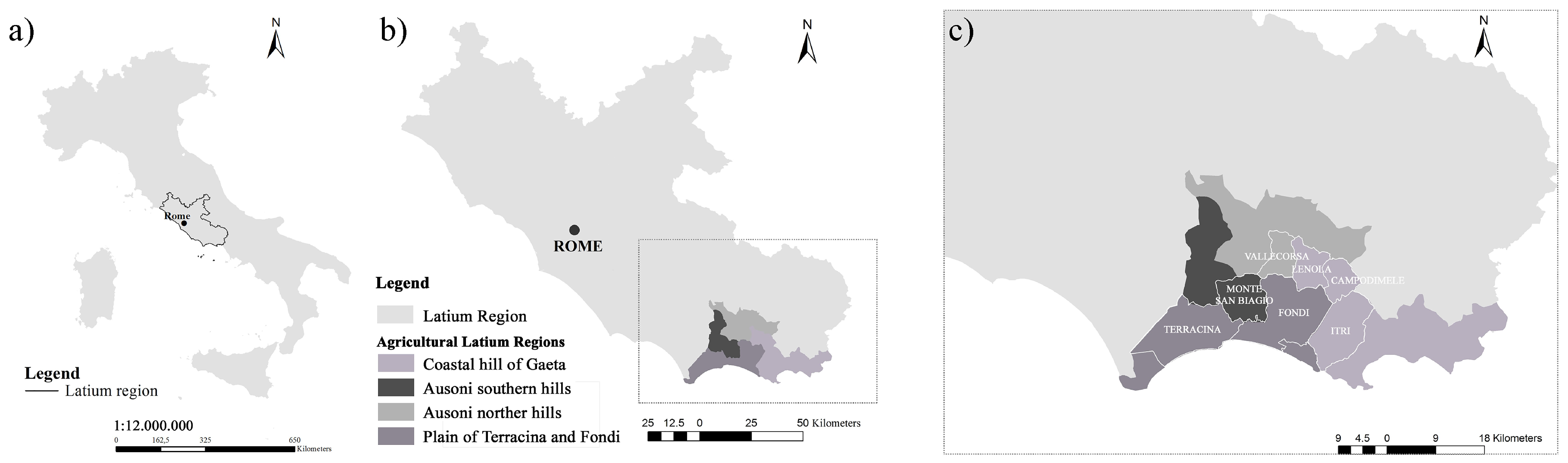
2.1. Study Area

The study area is located in southern Latium, central Italy (Figure 1a), being characterized by a traditional agricultural asset based on extensive and poly-cultural tree-based crops [39]. The study area hosts a highly perceived historical rural landscape included in the national catalogue of the Italian Ministry of Agricultural, Food and Forestry Policies [45], i.e., the terraced olive groves of Vallecorsa (province of Frosinone), a small and well preserved agro-system (600 ha; 41°26′43′′ N, 13°24′45′′ E) of recognized cultural value. In this territory, terraced systems are peculiar landscape elements that date back to the Roman period. With the exception of the rural landscape included in the catalogue, most of them are unknown and neglected.
The study area covers 4 homogeneous agricultural districts, a territorial classification adopted by official statistics in Italy since the beginning of the last century (1929), aiming at the economic evaluation of rural land, grouping contiguous areas sharing common land-use types and environmental characteristics [46]: (a) coastal hills of Gaeta; (b) plain of Terracina and Fondi; (c) Ausoni southern hills; and (d) Ausoni northern hills (Figure 1b), being administered by 7 municipalities overall (Figure 1c).
The whole study area is characterized by a marked geographical discontinuity, being typified by sequential hills and mountains, i.e., the Ausoni mountains (73.7% of the study area) and only to a lesser extent by flat land (26.3%). Consequently, vertical landscapes are predominant: elevation ranges between 240 m above sea level (a.s.l.) in the valley bottom to 800 m a.s.l. Complex topography is typical of the Mediterranean division (code 2 following the ecoregion classification [47]), including coastal and sub-coastal ascents along the Tyrrhenian borderland (code 2B). In particular, the study area is part of the Southern Lazio’ Subsection (Section 2B1d), that is characterized by complex mountain systems (i.e., the system of Volsci mountains composed by Monti Lepini, Monti Ausoni, Monti Aurunci) and a narrow coastal plain (i.e., the mid-Tyrrhenian coastal strip of Terracina and Fondi). Traditional and low-input agricultural landscapes, mainly non-irrigated arable land and tree crops, extended across 54% of the total area; mixed evergreen forests, Mediterranean maquis and pine forests occur in natural and semi-natural areas (more than 40% of the total area). Climate is typical of the boundary between the Mediterranean and the temperate climatic regions, with mean annual rainfalls ranging from about 600 mm at sea level to 1500 mm in the mountain belt. Mean annual temperature ranges between 13 °C and 17 °C moving from the coastal areas to the top of the mountains. Maximum temperatures in summer are generally below 30 °C. Summer aridity is moderate and generally shorter than 3 months.
Olive (Olea europaea L.) is the typical agricultural production of the study district, based on the cultivar Itrana, an appreciated autochthonous Italian double aptitude olive variety that gives naturally workable table olives following transformation procedures grounded on the ancient Greek tradition [48]. This being typical olive production, i.e., the Oliva di Gaeta PDO (Protected Designation of Origin) recognized throughout the four aforementioned agricultural regions, the data for terraced olive groves in this territory are jointly presented and discussed without distinguishing among these administrative delimitations. Two types of olive groves were identified as representative of the terraced agro-ecosystems: the poly-cultural olive groves and the specialized ones (Figure 2), although characterized by low-density planting (<200 trees/hectare) and exhibiting different soil management techniques: low-intensity tillage and spontaneous herbaceous grass coverage (twice moved with residues left on the ground as mulch) in the poly-cultural olive systems and periodical (three or more times) mechanical tillage (at a depth of 10–20 cm) in the specialized ones.
Finally, the study area is also known for many other certified traditional and typical forms of production based on local landraces [39] and specific measurements have been adopted for their in situ on-farm preservation [34]. For example, pastures are sustaining the livestock of the white goat ‘Monticellana’, an indigenous breed of domestic goat threatened by genetic erosion.

2.2. Terraced Landscape Analysis

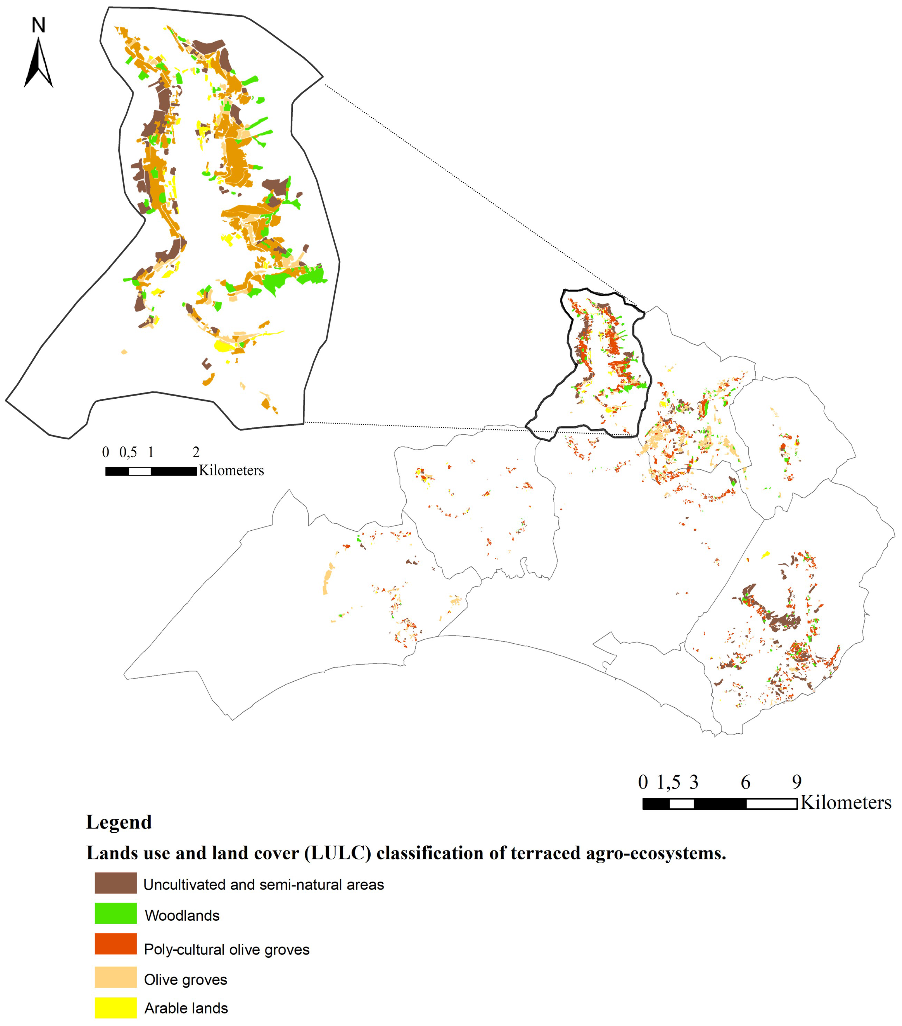
2.2.1. Land-Use and Land-Cover Dynamics

Assessment of the terraced agro-ecosystems in the study area was carried out within a GIS (geographic information system) environment. Terraces were mapped following technical indications provided in Cullotta and Barbera [4], i.e., by direct photo-interpretation of dry-wall linear elements. Land-use and land-cover (LULC) changes were evaluated by diachronic analysis of digital maps covering the time lapse between 1960 and 2012 [46,49]; this time period was partitioned in two time intervals (1960–2000 and 2000–2012), being representative of a long- and short- time horizon, respectively. Digital maps used in this study include: (i) the 1960 Touring Club Italy and National Research Council (TCI/CNR) land-use map (1:200,000); the 2000 Corine Land Cover map (CLC); and a land-use map dated 2012 (1:2000) obtained by direct photo-interpretation of aerial photographs (www.pcn.minambiente.it/mattm/) using tools provided by ArcGIS software. The LULC classes were organized into 10 thematic aggregations (urban fabric, arable lands, vineyards, orchards, olive groves, associated tree crops, pastures, uncultivated areas, woodlands, and greenhouses).

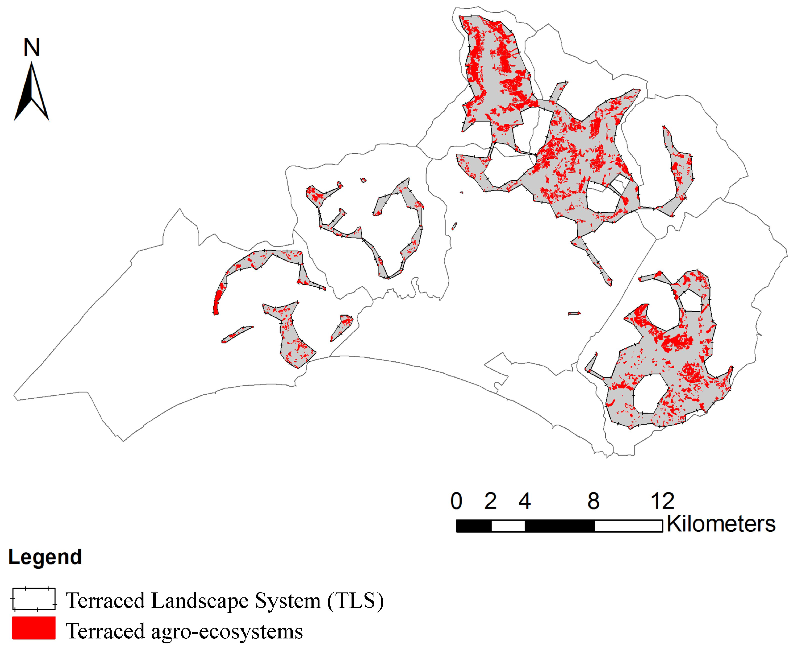
2.2.2. Terraced Landscape Mapping

The prevalent land use for each terraced agro-ecosystem was mapped at a scale of 1:2000 as vector polygons by photo-interpretation of aerial photographs referring to 2012 (www.pcn.minambiente.it/mattm/). Two classes were distinguished based on the main land-use: (i) cultivated terraces (specialized olive groves, poly-cultural olive groves, pastures and meadows); and (ii) uncultivated terraces (woodlands and semi-natural areas) according to Barbera et al. [11]. Terraced landscape systems (TLS) were identified by the aggregation pf terrace polygons when reciprocal distance was equal or lower than 500 m. This procedure was set up in order to identify a terraced ecosystem and to overcome the underestimation of terraced agro-ecosystems owing to the inability to distinguish on the aerial photographs the presence of dry stone walls when covered by woodland, or in cases where access to the area was difficult for field surveying. Furthermore, this distance can be considered suitable for assuring continuity and ecological connectivity among the agro-ecosystems.
A standard 50 m depth buffer zone alongside the polygon perimeter was delineated for each TLS. This buffer width is in accordance with previous formulated methodology [32] and was adapted to the large scale of landscape analysis. A multi-temporal analysis of land-use and land-cover dynamics (1960–2000 and 2000–2012) in the contact spaces was carried out to infer ecological fragility and resilience of the studied agro-ecosystems. The spatial distribution of cultivated or uncultivated terraced agro-ecosystems in respect to land slope was assessed by calculating the percent slope of each map polygon derived from a 20 m digital elevation model (DEM). A landscape ecology analysis was finally carried out in the TLSs by computing basic land metrics [50] and comparing the terraced landscapes with surrounding non-terraced landscapes [49,51].

2.2.3. Soil Indicators

Bulk soil samples were collected during autumn 2015 in two representative terraced olive agro-ecosystems: a specialized (41°17′0.79′′ N; 13°29′27.98′′ E) and a poly-cultural olive grove (41°17′18.38′′ N; 13°45′1.35′′ E). Three soil replicates per agro-ecosystem were taken from 0–20 cm topsoil using an auger. Soil quality was assessed according to the protocol illustrated by Brunori et al. [52]. In particular, soil total organic carbon (TOC) was determined in the dried sediments using a LECO CR-412 Carbon Analyzer (LECO Corp., St. Joseph, MI, USA); the microbial carbon biomass (MBC) was measured on the moist samples using the fumigation–extraction method; the nitrogen stock (total N) was measured using Kjeldahl’s procedure. Soil total enzymatic activity (TEA) was measured according to Mondini et al. [53].

2.2.4. Data Analysis

Statistical analysis was carried out using R software (version 2.11.1). Pair-wise correlations between land slope class and terraced land use (percentage in total area) were determined by Pearson coefficients testing at p < 0.05 for significance. A linear regression analysis was carried out to find the best fitting to observed data; a t-test inference was run to verify the significance of each relationship. One-way analysis of variance (ANOVA) was used to determine significant differences among the soil-quality variables considered in this study. Landscape metrics and soil-quality indicators for each TLS were also analysed by principal component analysis (PCA).

3. Results

3.1. Landscape Transformations in a Marginal Agricultural Area

Results of land-use and land-cover analysis for the years 1960, 2000 and 2012 are reported in Table 1. The studied landscape was dominated by agricultural use; nonetheless, the utilized agricultural area to total agricultural area (UAA/TAA) decreased from 85.8% in 1960 to 66.8% in 2012. Arable land and pastures are the main agricultural use in the area, ranging from 56.6% of TAA in 1960 to 40.6% in 2012. Olive groves were the most common tree crop in the area, representing 9.9% of the TAA in 2012. Artificial surfaces (urban fabric) extended on 0.6% of the total area in 1960 rising to 6.2% and 11.7%, respectively, in 2000 and 2012 (Table 1). Abandoned land including uncultivated spaces and woodland, increased drastically over the considered period.

3.2. Terraced Landscape Mapping, Terraced Landscape Systems (TLS) and Contact Spaces’ Land-Use Evolution

The spatial distribution of terraced landscapes in the study area derived by manual interpretation of recent aerial photography (2012) is shown in Figure 3. Terraces extended 2658 hectares (Table 2), representing 3.6% of the total area. Uncultivated terraces represented 37.6% of the terraced agro-ecosystems (Table 2), being primarily covered by semi-natural (low) vegetation and woodland. When cultivated, the terraced agro-ecosystems were prevalently devoted to poly-cultural olive groves (associated with tree crops) and, to a lesser extent, to specialized olive groves. TLS, delimited by the aggregation of terraces’ patches (Figure 3) extended over 3175 hectares in the study area. Cropland was 74% of total agricultural area, followed by semi-natural areas (18%) and artificial surfaces (8%).
Analysis of land-use changes in TLS reveal a substantial increase in urban fabric (22.1% by year), woodlands (0.9%) and specialized fruit orchards (4.1%) over 1960–2012. Olive grove surface area decreased by 0.3% per year. Rates of change were more rapid in the most recent period (0.9% per year between 2000 and 2012); a total of 522.6 hectares of olive groves were lost during the last 52 years. By contrast, vineyards have mostly disappeared during the first time period investigated (−2.5%; from 121.9 ha in 1960 to 1.2 ha in 2000), although a positive annual growth rate (111.9%) was observed in the short term, leading to a moderate recovery of terraced surfaces up to 17.6 ha. The recent land-use and conservation status of the TLS are reported in Figure 4. A more detailed analysis of land-use and land-cover evolution in the TLS is presented in the form of supplementary materials (Table S1). In the buffer zone surrounding the TLS (1450 ha), land-use and land-cover changes were rather similar in the short-term period (2000–2012). In particular, the main changes included: (i) an increase in urban fabric (156%), specialized fruit orchards and vineyards (515%), uncultivated semi-natural areas (22%); and (ii) a progressive decline in mixed-tree crop systems (−66%), and arable land (−13%).

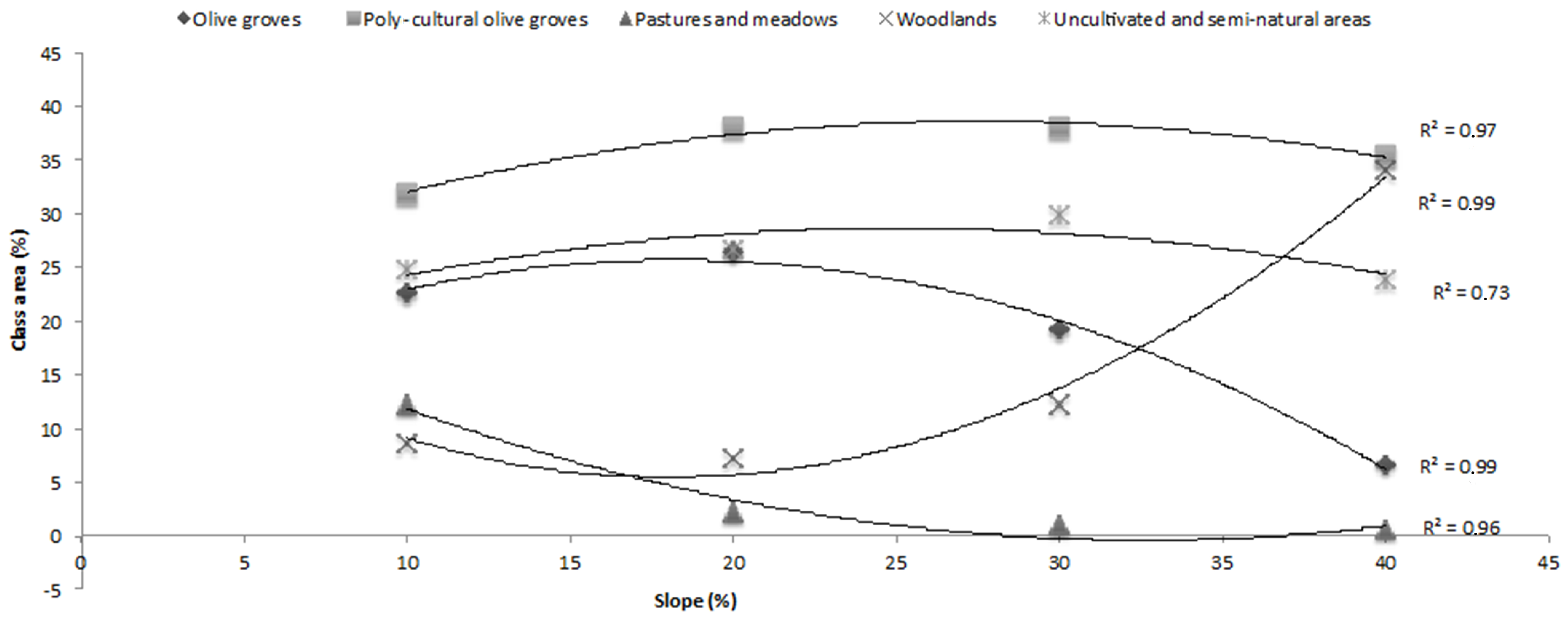
3.3. Slope Influence on Terrace Distribution and Land Use

Land slope influences terraced land use. The distribution of terraced land use for each slope class (%) is illustrated in Table 3. Terraces were most common in a slope class ranging from 10% to 30%, where agriculture is the dominant land use; behind this limit, i.e., with a slope up to 40%, uncultivated land extended more than 50% of the total surface area. For each slope class, the prevalent terraced land use was represented by poly-cultural olive groves (ranging from a minimum of 31.8% to a maximum of 37.9%), in respect of specialized olive cultivation, occurring mainly at lower slopes. Semi-natural areas were prevalent on abandoned terraces, with the exception of the highest slopes (woodland > 30%). The distribution of cultivated terraces on sloping land was demonstrated to follow a square relationship (Figure S1).
The relationship between slope class and the percent share of each land-use class in the total landscape area is illustrated in Figure 5. With the exception of poly-cultural olive groves, all considered classes are correlated to slope; a significant correlation was especially observed for specialized olive groves, woodlands and pastures (Table S1); a reverse pattern between slope and olive groves or woodlands was also observed. The kernel density plot (Figure 6) highlights a spatial association between terraced land-use and land-slope classes. Plots report the distribution of terraced systems and the related land use according to slope (from 10% to 40%). Pair-wise correlations between land-use changes and slope are illustrated in the right side of the plot’s diagonal. Olive groves, pastures and woodlands showed the highest correlation coefficients with slope. High correlation coefficients were also shown between olive groves and woodlands (r = −0.99), and between poly-cultural systems and pasture (r = −0.80) or uncultivated areas (r = 0.72).

3.4. Landscape Metrics

Landscape structure was analyzed for each class in the TLS and compared with surrounding, non-terraced landscapes using basic metrics (Table 4). Olive groves, both specialized and in particular the poly-cultural form, were characterized by higher density (PD, patch density), smaller patch size, and a more regular patch shape (MSI, mean shape index) in non-terraced landscape systems than in terraced ones. In the TLS, olive surfaces present similar structural traits, with the exception of ED (edge density), indicating patch complexity, much higher for the poly-cultural olive groves. In the non-TLS, the poly-cultural olive cultivation proved to be highly fragmented (high PD and low MPS) and in general the olive landscape proved to be heterogeneous. By contrast, TLS were characterized by a small patch size (MPS) and high density of natural land patches (woodland and semi-natural areas). At landscape level, landscape diversity and richness, as assessed using both Shannon’s diversity and evenness index (SDI and SEI), was greater in terraced landscapes than in non-terraced landscapes, as indicated by the higher absolute values of both these ecological indices.

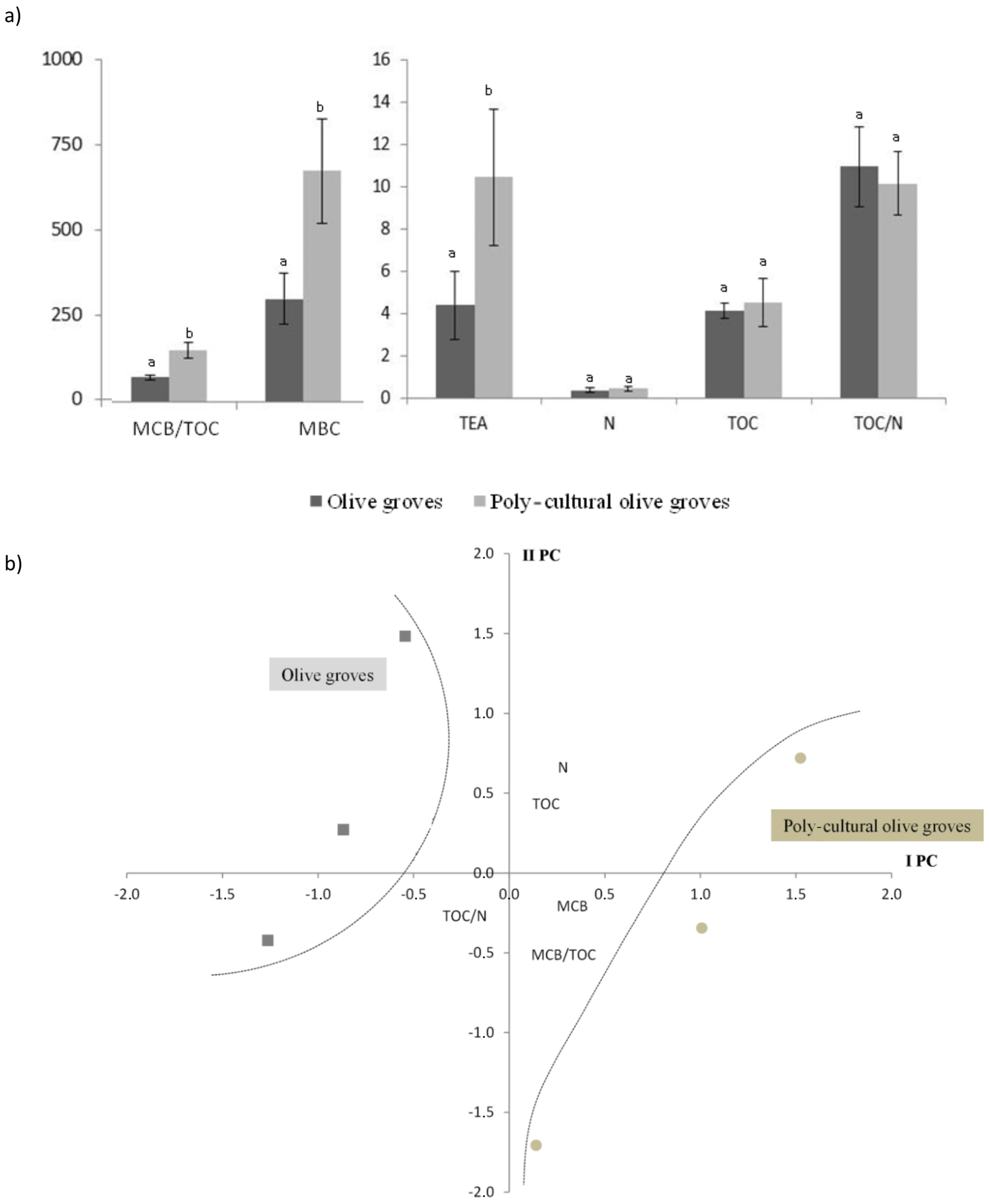
3.5. Soil Indicators

Soil nitrogen (N) and carbon content (TOC) were slightly higher in the poly-cultural olive groves than in specialized ones (Figure 7a). Microbial biomass content (MBC) in the poly-cultural olive groves’ soil amounted to 681.6 µgC·Kg dry soil−1 in the upper 0.20 m, twice as much as in the specialized systems (Table S2). Significant differences were shown for total enzyme activity (TEA), microbial biomass (MBC) and MCB/TOC (Table S2). A PCA (Figure 7b) was carried out on a data matrix composed of soil indicators measured for each TLS in order to assess the relationship between chemical and microbiological soil traits and the cultural management systems, i.e., the specialized olive groves and the poly-cultural ones. Two components were selected explaining 70.4% (PC1) and 17.5% (PC2) of the total data variance. PC1 and PC2 were, respectively, related to soil biological traits (i.e., biomass content and TEA) and to soil chemical attributes (i.e., N, TOC and C/N). The poly-cultural olive groves were associated to high value of TEA, MCB and MCB/TOC ratio (Figure 6b), while the specialized crop fell in the opposite quadrant, being associated with high values of soil chemical attributes.

4. Discussion

Our study has considered two pivotal aspects of terracing: (i) land-use and land-cover transformations in both long and short periods and (ii) the related ecosystem services, investigating landscape and soil issues. Following the European Landscape Convention (ELC, Florence Italy 2000), the international treaty promoted by the Council of Europe for the preservation of the landscape as common heritage, any landscape needs consideration and proper strategies for avoiding degradation and loss of primary functions, including biodiversity conservation, environment preservation, wellness and food quality [54]. The study area falls into one of the most neglected districts in central Italy, owing to steep topography, poor climate quality and economic marginality. However, its natural [41] and cultural values are well documented. In fact, this district is crossed by one of the most important European cultural landscapes, i.e., the ancient Roman Appia road (the “Regina viarum” in the ancient Roman age), a ‘linear landscape’ running from Rome to the southern Adriatic sea coast where nature, agriculture and archaeology meet [55]. Being considered a resilient district of traditional agriculture, from which certified typical and traditional products come [39], our investigation prove that this territory is indeed affected by relevant transformations when the terraced agro-ecosystems are considered.
In this area, the UAA (utilized agricultural area) has been eroded to less than 70% of the total agricultural area (TAA) at a 0.8% annual rate, even if in the recent past a recovery of cropland was observed, in accordance with a general European trend that exhibited a slowdown in the erosion of the UAA in the last decade [56], that can be attributed also to the adoption of new agricultural policies. The observed decrease in the UAA consumption rate is traditionally related to economic causes [57]. In the last decade (2000–2012), urbanization slowed owing to country-specific factors grounded in the 2007 financial crisis affecting Mediterranean countries [58,59,60]. Similar trends were observed for land abandonment as a result of economic marginalization, triggering local-scale development processes where uncultivated and underutilized land became available for new economic opportunities [61].
Landscape transformations towards urbanization, agricultural intensification vs. extensification, or afforestation vs. deforestation in the period 1990–2000 were identified for most of the European countries [62]. In general, Italy has been only marginally touched by the massive agricultural intensification frequently occurring in other European countries. By contrast, a significant re-naturalization and forest expansion seem to be the main recent landscape trends, being related to the fact that in Italy almost 1.5 million hectares of cropland were abandoned over the past 40 years, 70% of which is sloping land [63].
In the study area, the main landscape changes included a rapid expansion of urban settlements (+38% per year) and a uneven increase of uncultivated areas and woodland, paralleling the consistent decrease of both specialized agricultural systems (like fruit orchards) and poly-cultural agro-ecosystems, as highlighted in previous studies [15]. Nonetheless, pastures, vineyards and greenhouses increased recently in the studied district, probably owing to specific measures supporting traditional products and landraces promoted by national Rural Development Plans or by local strategies for autochthonous biodiversity conservation [34]. Empirical evidence from our study reflects a typical process of landscape transformations representative of the most common trends in Italy and other Mediterranean countries [29,49,64], characterized by land abandonment and urbanization, and leading to a progressive expansion of ecologically-sensitive areas. Urbanization involved areas progressively farther away from metropolitan regions, causing ecosystem fragmentation and ecological disturbances [60], woodland expansion as a consequence of cropland abandonment, and increased wildfire risk [15]. In fact, by involving the presence of incomplete ground cover, sparce grass or/and shrubs, together with bare soil, re-naturalization increases the risk of land-degradation phenomena.
The consumption of productive land driven by urbanization has endangered soil capability for agricultural purposes with a consequent impact on agricultural productivity and economic losses in marginal areas [65]. For example, the surface area of specific cropping systems such as fruit orchards (a strategic sector for Italian agriculture), has been eroded by one third in the last three decades [66].
In this changing scenario, olive cultivation exhibits a higher stability in many countries [56,66], likely thanks to the moderate agronomic inputs required by this crop, the popularity of the Mediterranean diet and local market demand–supply needs [26], together with the olive’s widely recognized resistance to drought, diseases and wildfire. In our study area, olive groves proved to be a rather stable (or weakly declining) agricultural system. Being a quite resilient agricultural land use in the Mediterranean basin and an extensive crop suitable for sloping land, olive cultivation may be a key land use for counteracting land abandonment and soil degradation [13]. Furthermore, it may represent a permanent agricultural landscape addressing specific sustainability goals. Permanent crops, in fact, have been recognized as strategic agro-ecosystems assuring conditions for socioeconomic and environmental sustainability even in highly specialized agricultural land [67].
Land-use and land-cover dynamics become particularly interesting and specific across space when TLS are considered. We identified the TLS, i.e., a vulnerable land use, by aggregating proximal (≤500 m) terraced agro-ecosystems with the aim of considering a district rather than a place; as proved in previous research, mapping environmentally sensitive areas allow strategies for a whole local community instead of for a single area to be addressed and efforts to be optimized [39]. Mapping terraced agro-ecosystems is a key step for landscape governance; for example, available terrace maps for Italy underestimate total surface area [11]. Detailed mapping of ecosystems, mainly available at large scale, is crucial for addressing biodiversity conservation and biodiversity-related ecosystem services, or for identifying collapse risk in the delimited landscape systems [68].
Earlier studies have quantified the loss of terraced agro-ecosystems in Italy over the past 50 years [19], presenting values close to 40% in Tuscany, central Italy [5,6], 33% in Liguria, northern Italy [69], and 85% in Calabria, southern Italy [27]. In this regard, our study has estimated land-use changes over both long and short time horizons in the identified TLS and proximal buffer area (terraces’ contact areas) and the amount of abandoned terraces.
The spatial distribution of terraces on sloping land of southern Latium resembles the typical distribution of land use along elevation gradients in the Mediterranean region, with terraced land concentrated on slopes ranging between 10% and 40% [6,11,13]. Our results demonstrate that terraced land use and land abandonment were strongly correlated to slope gradients. The highest rates of land abandonment were found in both 20–30% and 30–40% slope classes; the dominant presence of woodland and wildness invasion at higher slopes proved a characteristic cropland abandonment sequence. Earlier studies have demonstrated that soil erosion, landslides and land abandonment in terraced landscapes are strongly related to slope gradient [70]. Nonetheless, steep slopes covering vegetation or cultivation have a moderate impact on landslides. It has been also demonstrated that recently-abandoned terraces (25–30 years) are exposed to a higher collapse risk in comparison to those abandoned a long time [21]. The agricultural terraced landscape is a deeply modified environment; when abandoned, it is subjected to gradual uneven recovery by grasses, shrubs and woods (re-naturalization) that are the land-cover classes most prone to shallow landslides and, in general, to land degradation. The cultivation of terraces can, therefore, be considered the most effective land-stabilizing element in the short to medium period.
In our district, cultivated terraces are mainly characterized by poly-cultural olive groves, i.e., olive trees associated with fruit trees and/or vines. This mixed cropping system is still considered one of the most multi-functional and traditional agricultural landscape in the Mediterranean region. Owing to their exceptional nature, resilience and conservation status, some Italian tree-crop terraces intended as poly-cultural landscapes have been inserted in the list of human heritage provided by UNESCO. Examples are the grape-wine growing landscape of Roero and Monferrato (Piedmont, northern Italy) and the Amalfi coastal district (Campania, southern Italy), hosting terraced citrus cultivation, chestnut woodland and fruit orchards (www.unesco.it). Losing poly-cultural agro-ecosystems owing to terraced land abandonment can, therefore, be considered a loss in the ecological and aesthetic quality of rural landscapes. The linkage between ecological and aesthetic values is a challenging issue in landscape conservation [71,72]. Many are the ecological benefits that poly-cultural agro-ecosystems may provide, including (i) the regulation of micro-climatic regimes and local hydrological processes, and (ii) the reduction of external inputs through containment of undesirable organisms and detoxification of noxious chemicals [73]. Furthermore, the soil-retaining capacity of tree roots on sloping land and the high efficiency of natural coverage in comparison to the regularity of planting schemes in modern crop systems has been demonstrated [24]. The disappearance of poly-cultural tree crop-based ecosystems—characterized by irregular planting architecture and heterogeneous root-system distribution owing to landrace’s genetic diversity—may result in a loss of efficient land uses and hence land instability and loss of soil functions. Finally, it has to be considered that the maintenance of the link between plant genetic resources and traditional knowledge is a key objective of the intergovernmental Convention on Biological Diversity [74].
In our study area, TLS were experiencing uneven geophysical changes; on cultivated terraces, poly-cultural olive groves are relatively stable irrespective of land slope. In fact, while the spatial distribution of specialized olive groves and woodlands was correlated with slope in a diverging way (respectively decreasing and increasing with the elevation gradient), poly-cultural olive groves were present with the same frequency in all slope classes (from 10% to 40% slope), proving, therefore, a strong resilience. Landscape-level analysis carried out in this study was aimed at a comprehensive characterization of ‘vertical landscapes’. Most frequently, for farmland and landscapes of high natural value, studies have been done only at a small scale, restricted cropping systems have been characterized, and sectoral strategies have been proposed for sustainable land planning and management.
It is known that terraces—and more generally traditional rural landscapes—contribute to preserve an heterogeneous eco-mosaic with higher biodiversity and higher ecosystem complexity [12,75,76]. Our terraced cropland (TLS) exhibits less fragmented and spatially-heterogeneous landscape indexes in comparison with non-terraced systems, where specialized agricultural systems prevail. This could be attributed to the resilience of the stone walls or stone artifacts, limiting agricultural patch fragmentation. The comparative analysis of landscape metrics between TLS and neighboring non-TLS indicates that terraced cropland shows high biodiversity and complexity, as proved by the values of the diversity and evenness ecological indexes (i.e., SDI and SEI) stressing the high environmental value of the vertical agricultural landscape.
By contrast, TLS are seriously endangered, being susceptible to changes in proximal land use. A high level of agricultural landscape disturbance, i.e., fragmentation and simplification, was measured in non-TLS, as the high number (PD) of small sized (MPS) patches of regular shape (ED) demonstrate. These attributes indicate a landscape shifting toward modern agro-ecosystems, characterized by simplified land metrics [49]. In Latium, terraces are characterized by regular, small, narrow and flat benches [37]. The small size of patches could be the pivotal factor triggering terraces’ abandonment, since narrow cultivated terraces require high labor intensity [77].
Finally, terraces’ soil-related ecosystem services were considered in this study in respect of olive groves (specialized vs. poly-cultural), the main agricultural use of the terraces. Our results demonstrate that poly-cultural agro-ecosystems, assure soil healthiness better than specialized ones. In particular, the study proved that poly-cultural olive agro-ecosystems assure the maintenance of soil global fertility. Soil consumption in the Mediterranean basin is occurring at the expense of fertile soil [78], leading to loss in organic carbon (TOC), mineral-element cycle disturbance, and water-resource depletion. Traditional tree and vine cultivations may act as an ecological buffer against desertification in endangered areas [79]. Soil analysis for poly-cultural olive groves indicates a characteristic presence of higher TOC content, higher microbial biomass (MCB/TOC) and intense enzymatic functions (TEA). These variables were used for soil functionality scoring and fertile-class attribution and evaluation of soil healthiness [80]. All the considered indexes of soil biological fertility resulted as linked to poly-cultural agro-ecosystems, while variables assessing soil chemical fertility were associated with specialized olive groves, as the multivariate analysis clearly demonstrates. Earlier studies documented that terraced agro-ecosystems exhibit better soil quality (soil depth, water content, mineral) than non-terraced ones [76]. In particular, soil management affects SOC in olive groves [81], leading to a high carbon stabilization rate. Preservation of terraced agro-ecosystem with extensive, low input-requiring poly-cultural systems has gained ecological importance in relation to soil conservation. Results concerning soil functionality in terraced agro-ecosystems proved how poly-cultural olive groves contribute to sustaining soil biological fertility and environmental quality. Maintenance of soil-related ecosystem services is a key factor in landscape and environmental design, restoration and management [82,83]. Sustainably managed soils, as in the poly-cultural olive groves, exhibit greater biological activity (total enzyme activity) than in conventionally managed soils typical of the specialized olive grove, in accordance with Bowles et al. [84] and Palese et al. [85]. Particularly high values of MBC and MBC/TOC can be linked to the greater potential activity of most enzymes, as reflected by total enzyme activity, an indicator of microbial metabolic capacity and recycling of nutrients [77].

5. Conclusions

In Italy, a “vertical” country where mountains and hills account for most of the national surface area, terraced agro-ecosystems include tree-crop based landscapes, mainly olive groves, vineyards, fruit and citrus orchards. While being extensively used for agriculture, terraces and stone walls are sinks of soil, plant and animal biodiversity, preserving functionally complex ecosystems. An increased awareness of these key environmental functions in farmers could increase the use of the multiple measures available through agricultural policies aiming at conservation. Nonetheless, territorial or local conservation strategies cannot derive from research and development actions and extension training. In fact, for long-lasting results, concerted strategies for terrace conservation and restoration require a comprehensive investigation of spatial distribution, state of conservation, present and past evolution in land use and land cover, and quantification of ecosystem services. Therefore, an integrated characterization of the terraced landscape system based on mapping and classification, land metric analysis, biodiversity evaluation and soil functionality measurements, as this study proposes, represents in itself a conservation strategy of natural resources in sloping areas. Complex tree-crop systems, like the poly-cultural olive groves, were identified as sustainable crop systems, stable over time and requiring low external inputs, with efficient carbon storage and soil-quality preservation. This practical information derived from this research could result in best practices consisting of integrated landscape management based on: (i) agronomical measures (like the conservation of the extensive low input-requiring agro-ecosystems and organic farming); (ii) physical environmental measures (like the maintenance or establishment of new stone walls following traditional knowledge); (iii) landscaping intervention (like the management of the buffer strips, natural and semi-natural remnants). In particular, this latter practice could allow the terraced agro-ecosystems to become favorite sites for biomass production, bio-energy landscapes resilient to environmental change, by assuring in the meantime a diversification of a farm’s business and, perhaps, a slowdown of terrace abandonment or a recovery of those that have been abandoned.

Supplementary Materials

The following are available online at https://www.mdpi.com/2071-1050/10/4/1164/s1, Figure S1: Distribution of the terraced agro-ecosystems’ land area (%) in relation to slope classes (%); Table S1: Land use and land cover (LULC) change in the terraced landscape systems (TLS) and in the proximal spaces (buffer 50 m depth) in the short (2000–2012) period. TLS were delimited by the aggregation of terraced agro-ecosystems for a distance one from the other ≤500 m; Table S2: Soil bio-chemical indicators of two typical terraced agro-ecosystems: specialized and poly-cultural olive groves. N—total nitrogen; TEA—total enzyme activity; TOC—total organic carbon. MBC—microbial biomass carbon. (*, p < 0.05 significant; **, p < 0.01 highly significant; ns, not significant).

Acknowledgments

Research was funded by the Ministry of University Research and Education (MIUR) Project PRIN 2010–2011 (Prot. 2010LE4NBM_005). The authors would like to thanks ARSIAL (Agency for the Development and Innovation of Agriculture in the Latium Region) and its technical personnel for field survey assistance and Roberta Farina (CREA) for soil-sample analysis. The authors also thank the farmers of ‘Villa Wanda’, Itri (Latina) and of the farm ‘Magliozzi’, Minturno (Latina) for allowing field data collection.

Author Contributions

Rita Biasi conceived the research design; Elena Brunori collected and processed the empirical data; Angela Antogiovanni provided visual interpretation of aerial photographs; Luca Salvati carried out the literature analysis; Rita Biasi and Luca Salvati analyzed and interpreted the empirical results of this research, and wrote the whole manuscript.

Conflicts of Interest

The authors declare no conflict of interest.

References

  1. Blondel, J.; Aronson, J. Biology and Wildlife of the Mediterranean Region; Oxford University Press: Oxford, UK, 1999; 328p, ISBN 9780198500360. [Google Scholar]
  2. Arnáez, J.R.; Lana-Renault, N.; Lasanta, T.; Ruiz-Flaño, P.; Castroviejo, J. Effects of farming terraces on hydrological and geomorphological processes. A review. Catena 2015, 128, 122–134. [Google Scholar] [CrossRef]
  3. Asins-velis, S.; Arnau-rosalén, E.; Romero-Gonzáles, J.; Calvo-Cases, A. Analysis of the consequences of the European Union criteria on slope gradient for the delimitation of “areas facing natural constraints” with agricultural terraces. ANNALES Ser. Hist. Sociol. 2016, 26, 433–448. [Google Scholar] [CrossRef]
  4. Cullotta, S.; Barbera, G. Mapping traditional cultural landscapes in the Mediterranean area using a combined multidisciplinary approach: Method and application to Mount Etna (Sicily; Italy). Landsc. Urban Plan. 2011, 100, 98–108. [Google Scholar] [CrossRef]
  5. Tarolli, P.; Preti, F.; Romano, N. Terraced landscapes: From an old best practice to a potential hazard for soil degradation due to land abandonment. Anthropocene 2014, 6, 10–25. [Google Scholar] [CrossRef]
  6. Agnoletti, M.; Conti, L.; Frezza, L.; Santoro, A. Territorial Analysis of the Agricultural Terraced Landscapes of Tuscany (Italy): Preliminary Results. Sustainability 2015, 7, 4564–4581. [Google Scholar] [CrossRef]
  7. Colantoni, A.; Mavrakis, A.; Sorgi, T.; Salvati, L. Towards a ‘polycentric’ landscape? Reconnecting fragments into an integrated network of coastal forests in Rome. Rend. Accad. Naz. Lincei 2015, 26, 615–624. [Google Scholar] [CrossRef]
  8. Savo, V.; Caneva, G.; McClatchey, W.; Reedy, D.; Salvati, L. Combining environmental factors and agriculturalists’ observations of environmental changes in the traditional terrace system of the Amalfi Coast (Southern Italy). Ambio 2014, 43, 297–310. [Google Scholar] [CrossRef] [PubMed]
  9. Kosmas, C.; Karamesouti, M.; Kounalaki, K.; Detsis, V.; Vassiliou, P.; Salvati, L. Land degradation and long-term changes in agro-pastoral systems: An empirical analysis of ecological resilience in Asteroussia—Crete (Greece). Catena 2016, 147, 196–204. [Google Scholar] [CrossRef]
  10. Calatrava, J.; Franco, J.A.; González, M.C. Analysis of the adoption of soil conservation practices in olive groves, the case of mountainous areas in Southern Spain. Span. J. Agric. Res. 2007, 5, 249–258. [Google Scholar] [CrossRef]
  11. Barbera, G.; Cullotta, S.; Rossi-Doria, I.; Rühl, J.; Rossi-Doria, B. I Paesaggi a Terrazze Della Sicilia. Metodologie per L’analisi, la Tutela e la Valorizzazione; Collana Studi e Ricerche dell’ARPA Sicilia; ARPA—Agenzia Regionale per la Protezione dell’Ambiente: Sicily, Italy, 2010; 525p, ISBN 978-88-95813-07-3. [Google Scholar]
  12. Bini, C.; Ferrarini, A.; Spiandorello, M.; Wahsha, M.; Zilioli, D.M. Landscape evolution and global soil change in alpine valleys: Impact of anthropedogenesis on terraced soils (Belluno, Northern Italy). EQA Int. J. Environ. Qual. 2017, 25, 1–17. [Google Scholar] [CrossRef]
  13. Koulouri, M.; Giourga, C. Land abandonment and slope gradient as key factors of soil erosion in Mediterranean terraced lands. Catena 2007, 69, 274–281. [Google Scholar] [CrossRef]
  14. Ceccarelli, T.; Bajocco, S.; Salvati, L.; Perini, L. Investigating syndromes of agricultural land degradation through past trajectories and future scenarios. Soil Sci. Plant Nutr. 2014, 60, 60–70. [Google Scholar] [CrossRef]
  15. Ferrara, A.; Salvati, L.; Sabbi, A.; Colantoni, A. Urbanization, Soil Quality and Rural Areas: Towards a Spatial Mismatch? Sci. Total Environ. 2014, 478, 116–122. [Google Scholar] [CrossRef] [PubMed]
  16. Serra, P.; Vera, A.; Tulla, A.F.; Salvati, L. Beyond urban-rural dichotomy: Exploring socioeconomic and land-use processes of change in Spain (1991–2011). Appl. Geogr. 2014, 55, 71–81. [Google Scholar] [CrossRef]
  17. Smiraglia, D.; Ceccarelli, T.; Bajocco, S.; Salvati, L.; Perini, L. Linking trajectories of land change, land degradation processes and ecosystem services. Environ. Res. 2016, 147, 590–600. [Google Scholar] [CrossRef] [PubMed]
  18. Barbati, A.; Corona, P.; Salvati, L.; Gasparella, L. Natural forest expansion into suburban countryside: Gained ground for a green infrastructure? Urban For. Urban Green. 2013, 12, 36–43. [Google Scholar] [CrossRef] [Green Version]
  19. Stanchi, S.; Freppaz, M.; Agnelli, A.; Reinsch, T.; Zanini, E. Properties, best management practices and conservation of terraced soils in Southern Europe (from Mediterranean areas to the Alps): A review. Quat. Int. 2012, 265, 90–100. [Google Scholar] [CrossRef]
  20. Lasanta, T.; Arnáez, J.; Oserín, M.; Ortigosa, L.M. Marginal lands and erosion in terraced fields in the Mediterranean mountains: A case study in the Camero Viejo (Northwestern Iberian System, Spain). Mt. Res. Dev. 2001, 21, 69–76. [Google Scholar] [CrossRef]
  21. Brandolini, P.; Cevasco, A.; Capolongo, D.; Pepe, G.; Lovergine, F.; Del Monte, M. Response of Terraced Slopes to a Very Intense Rainfall Event and Relationships with Land Abandonment: A Case Study from Cinque Terre (Italy). Land Degrad. Dev. 2017. [Google Scholar] [CrossRef]
  22. Camera, C.; Apuani, T.; Masetti, M. Modeling the stability of terraced slopes: An approach from Valtellina (Northern Italy). Environ. Earth Sci. 2015, 74, 855–868. [Google Scholar] [CrossRef]
  23. Salvati, L.; Ferrara, C. Unravelling landslide risk: Soil susceptibility, agro-forest systems and the socioeconomic profile of rural communities in Italy. Soil Use Manag. 2015, 31, 290–298. [Google Scholar] [CrossRef]
  24. Cislaghi, A.; Bordoni, M.; Meisina, C.; Bischettia, G.B. Soil reinforcement provided by the root system of grapevines: Quantification and spatial variability. Ecol. Eng. 2017, 109, 169–185. [Google Scholar] [CrossRef]
  25. Martínez-Casasnovas, J.A.; Ramos, M.C.; Cots-Folch, R. Influence of the EU CAP on terrain morphology and vineyard cultivation in the Priorat region of NE Spain. Land Use Policy 2010, 27, 11–21. [Google Scholar] [CrossRef]
  26. De Graaff, J. The future of olive groves on sloping land and ex-ante assessment of cross compliance for erosion control. Land Use Policy 2010, 27, 33–41. [Google Scholar] [CrossRef]
  27. Modica, G.; Praticò, S.; Di Fazio, S. Abandonment of traditional terraced landscape: A change detection approach (a case study in Costa Viola, Calabria, Italy). Land Degrad. Dev. 2017, 28, 2608–2622. [Google Scholar] [CrossRef]
  28. Biasi, R.; Colantoni, A.; Ferrara, C.; Ranalli, F.; Salvati, L. In-between sprawl and fires: Long-term forest expansion and settlement dynamics at the wildland-urban interface in Rome, Italy. Int. J. Sustain. Dev. World Ecol. 2015, 22, 467–475. [Google Scholar] [CrossRef]
  29. Ferrara, A.; Salvati, L.; Sateriano, A.; Carlucci, M.; Gitas, I.; Biasi, R. Unraveling the ‘stable’ landscape: A multi-factor analysis of unchanged agricultural and forest land (1987–2007) in a rapidly-expanding urban region. Urban Ecosyst. 2016, 19, 835–848. [Google Scholar] [CrossRef]
  30. Lesschen, J.P.; Cammeraat, L.H.; Nieman, T. Erosion and terrace failure due to agricultural land abandonment in a semi-arid environment. Earth Surf. Process. Landf. 2008, 33, 1574–1584. [Google Scholar] [CrossRef]
  31. Navarro, L.M.; Pereira, H. Rewilding Abandoned Landscapes in Europe Ecosystems. In Rewilding European Landscapes; Pereira, H., Navarro, L., Eds.; Springer: Cham, Switzerland, 2012; Volume 15, pp. 3–23. [Google Scholar]
  32. Biasi, R.; Brunori, E. The on-farm conservation of grapevine (Vitis vinifera L.) landraces assures the habitat diversity in the viticultural agro-ecosystem. Vitis 2015, 54, 265–269. [Google Scholar]
  33. Duvernoy, I.; Zambon, I.; Sateriano, A.; Salvati, L. Pictures from the Other Side of the Fringe: Urban Growth and Peri-urban Agriculture in a Post-industrial City (Toulouse, France). J. Rural Stud. 2018, 57, 25–35. [Google Scholar] [CrossRef]
  34. Porfiri, O.; Costanza, M.T.; Negri, V. Landrace inventories in Italy and the Lazio region Case Study. In European Landraces: Onfarm Conservation, Management and Use; Biodiversity Technical Bulletin No. 15; Veteläinen, M., Negri, V., Maxted, N., Eds.; Biodiversity International: Rome, Italy, 2009; pp. 117–123. ISBN 978-92-9043-805-2. [Google Scholar]
  35. Mauro, G. Agricultural Terraced Landscapes in the Province of Trieste (Northeastern Italy). In Geocomputation, Sustainability and Environmental Planning; Springer: Berlin/Heidelberg, Germany, 2011; pp. 91–109. [Google Scholar]
  36. Bailly, J.S.; Levavasseur, F. Potential of Linear Features Detection in a Mediterranean Landscape from 3D VHR Optical Data: Application to Terrace Walls. In Proceedings of the 2012 IEEE International Geoscience and Remote Sensing Symposium (IGARSS), Munich, Germany, 22–27 July 2012; pp. 7110–7113. [Google Scholar] [CrossRef]
  37. Sofia, G.; Marinello, F.; Tarolli, P. A new landscape metric for the identification of terraced sites: The Slope Local Length of Auto-Correlation (SLLAC). ISPRS J. Photogramm. Remote Sens. 2014, 96, 123–133. [Google Scholar] [CrossRef]
  38. Gómez, J.A.; Infante-Amate, J.; De Molina, M.G.; Vanwalleghem, T.; Taguas, E.V.; Lorite, I. Olive cultivation, its impact on soil erosion and its progression into yield impacts in Southern Spain in the past as a key to a future of increasing climate uncertainty. Agriculture 2014, 4, 170–198. [Google Scholar] [CrossRef]
  39. Biasi, R.; Brunori, E.; Smiraglia, D.; Salvati, L. Linking traditional tree-crop landscapes and agro-biodiversity in central Italy using a database of typical and traditional products: A multiple risk assessment through a data mining analysis. Biodivers. Conserv. 2015, 24, 3009–3031. [Google Scholar] [CrossRef]
  40. Duarte, F.; Jones, N.; Fleskens, L. Traditional olive orchards on sloping land: Sustainability or abandonment? J. Environ. Manag. 2008, 89, 86–98. [Google Scholar] [CrossRef] [PubMed]
  41. Di Pietro, R.; Blasi, C. A phytosociological analysis of abandoned olive-grove grasslands of Ausoni mountains (Tyrrhenian district of Central Italy). Lazaroa 2002, 23, 73–93. [Google Scholar]
  42. Rühl, J.; Caruso, T.; Giucastro, M.; La Mantia, T. Olive agroforestry systems in Sicily: Cultivated typologies and secondary succession processes after abandonment. Plant Biosyst. 2011, 145, 120–130. [Google Scholar] [CrossRef]
  43. Pardini, G.; Gispert, M. Soil quality assessment through a multi-approach analysis in soils of abandoned terraced land in NE Spain. Cuad. Investig. Geogr. 2013, 38, 7–38. [Google Scholar] [CrossRef]
  44. Allen, H.D.; Randall, R.E.; Amable, G.S.; Devereux, B.J. The impact of changing olive cultivation practices on the ground flora of olive groves in the Messara and Psiloritis regions, Crete, Greece. Land Degrad. Dev. 2006, 17, 249–273. [Google Scholar] [CrossRef]
  45. Agnoletti, M. Italian Historical Rural Landscapes: Cultural Values for the Environment and Rural Development; Springer: Dordrecht, The Netherlands, 2012; 545p, ISBN 978-94-007-5354-9. [Google Scholar]
  46. Biasi, R.; Botti, F.; Cullotta, S.; Barbera, G. The role of Mediterranean fruit tree orchards and vineyards in maintaining the Traditional Agricultural Landscape. Acta Hortic. 2012, 940, 79–88. [Google Scholar] [CrossRef]
  47. Blasi, C.; Capotorti, G.; Copiz, R.; Guida, D.; Mollo, B.; Smiraglia, D.; Zavattero, L. Classification and mapping of the ecoregions of Italy. Plant Biosyst. 2014, 148, 1255–1345. [Google Scholar] [CrossRef]
  48. Lanza, B.; Di Serio, M.G.; Iannucci, E. Effects of maturation and processing technologies on nutritional and sensory qualities of Itrana table olives. Grasas y Aceites 2013, 64, 272–284. [Google Scholar] [CrossRef]
  49. Brunori, E.; Salvati, L.; Mancinelli, R.; Smiraglia, D.; Biasi, R. Multi-temporal land use and cover changing analysis: The environmental impact in Mediterranean area. Int. J. Sustain. Dev. World Ecol. 2017, 24, 276–288. [Google Scholar] [CrossRef]
  50. Biasi, R.; Brunori, E.; Ferrara, C.; Salvati, L. Towards sustainable rural landscapes? A multivariate analysis of the structure of traditional tree cropping systems along a human pressure gradient in a Mediterranean region. Agrofor Syst 2017, 91, 1199–1217. [Google Scholar] [CrossRef]
  51. Brunori, E.; Cirigliano, P.; Biasi, R. Sustainable use of genetic resources: The characterization of an Italian local grapevine variety (‘Grechetto rosso’) and its own landscape. Vitis 2015, 54, 261–264. [Google Scholar]
  52. Brunori, E.; Farina, R.; Biasi, R. Sustainable viticulture: The carbon-sink function of the vineyard agro-ecosystem. Agric. Ecosyst. Environ. 2016, 223, 10–21. [Google Scholar] [CrossRef]
  53. Mondini, C.; Fornasier, F.; Sinicco, T. Enzymatic activity as a parameter for the characterization of the composting process. Soil Biol. Biochem. 2004, 36, 1587–1594. [Google Scholar] [CrossRef]
  54. Déjeant-Pons, M. The European landscape convention. Landsc. Res. 2006, 31, 363–384. [Google Scholar] [CrossRef]
  55. Rumiz, P. Appia; Feltrinelli: Milano, Italy, 2016; 362p, ISBN 9788807031908. [Google Scholar]
  56. Eurostat. Statistics Explained. Available online: http://epp.eurostat.ec.europa.eu/statistics_explained/ (accessed on 5 February 2018).
  57. Salvati, L.; Carlucci, M. The economic and environmental performances of rural districts in Italy: Are competitiveness and sustainability compatible targets? Ecol. Econ. 2011, 70, 2446–2453. [Google Scholar] [CrossRef]
  58. Munafò, M.; Salvati, L.; Zitti, M. Estimating soil sealing at country scale—Italy as a case study. Ecol. Indic. 2013, 26, 36–43. [Google Scholar] [CrossRef]
  59. Ceccarelli, T.; Bajocco, S.; Perini, L.; Salvati, L. Urbanisation and Land Take of High Quality Agricultural Soils—Exploring Long-term Land Use Changes and Land Capability in Northern Italy. Int. J. Environ. Res. 2014, 8, 181–192. [Google Scholar] [CrossRef]
  60. Pili, S.; Grigoriadis, E.; Carlucci, M.; Clemente, M.; Salvati, L. Towards Sustainable Growth? A Multi-criteria Assessment of (Changing) Urban Forms. Ecol. Indic. 2017, 76, 71–80. [Google Scholar] [CrossRef]
  61. MacDonald, D.; Crabtree, J.R.; Wiesinger, G.; Dax, T.; Stamou, N.; Fleury, P.; Gibon, A. Agricultural abandonment in mountain areas of Europe: Environmental consequences and policy response. J. Environ. Manag. 2000, 59, 47–69. [Google Scholar] [CrossRef]
  62. Feranec, J.; Jaffrain, G.; Soukup, T.; Hazeu, G. Determining changes and flows in European landscapes 1990–2000 using CORINE land cover data. Appl. Geogr. 2010, 30, 19–35. [Google Scholar] [CrossRef]
  63. FAO. World Agriculture: Towards 2015/2030 Summary Report; FAO: Rome, Italy, 2002; 106p, ISBN 92-5104761-8. [Google Scholar]
  64. Salvati, L.; Biasi, R.; Carlucci, M.; Ferrara, A. Forest transition and urban growth: Exploring latent dynamics (1936–2006) in Rome, Italy, using a geographically weighted regression and implications for coastal forest conservation. Rend. Lincei Sci. Fis. Nat. 2015, 26, 577–585. [Google Scholar] [CrossRef]
  65. Rivieccio, R.; Sallustio, L.; Paolanti, M.; Vizzarri, M.; Marchetti, M. Where land use changes occur: Using soil features to understand the economic trends in agricultural lands. Sustainability 2017, 9, 78. [Google Scholar] [CrossRef]
  66. INEA. Rapporto Sullo Stato Dell’agricoltura 2013. (A Cura Di) ISTAT 6° Censimento Generale Dell’agricoltura—Risultati Definitivi. 2011. Available online: www.istat.it/it/archivio/66591 (accessed on 1 October 2017).
  67. Zhang, Y.; Li, Y.; Jiang, L.; Tian, C.; Li, J.; Xiao, Z. Potential of perennial crop on environmental sustainability of agriculture. Procedia Environ. Sci. 2011, 10, 1141–1147. [Google Scholar] [CrossRef]
  68. Blasi, C.; Capotorti, G.; Ortí, M.M.A.; Anzellotti, I.; Attorre, F.; Azzella, M.M.; Marando, F. Ecosystem mapping for the implementation of the European Biodiversity Strategy at the national level: The case of Italy. Environ. Sci. Policy 2017, 78, 173–184. [Google Scholar] [CrossRef]
  69. Cevasco, A.; Pepe, G.; Brandolini, P. The influences of geological and land use settings on shallow landslides triggered by an intense rainfall event in a coastal terraced environment. Bull. Eng. Geol. Environ. 2014, 73, 859–875. [Google Scholar] [CrossRef]
  70. Giordan, D.; Cignetti, M.; Baldo, M.; Godone, D. Relationship between man-made environment and slope stability: The case of 2014 rainfall events in the terraced landscape of the Liguria region (northwestern Italy). Geomat. Nat. Hazards Risk 2017, 8, 1833–1852. [Google Scholar] [CrossRef]
  71. Booth, P.N.; Law, S.A.; Ma, J.; Buonagurio, J.; Boyd, J.; Turnley, J. Modeling aesthetics to support an ecosystem services approach for natural resource management decision making. Integr. Environ. Assess. Manag. 2017, 13, 926–938. [Google Scholar] [CrossRef] [PubMed]
  72. Gobster, P.H.; Nassauer, J.I.; Daniel, T.C.; Fry, G. The shared landscape: What does aesthetics have to do with ecology? Landsc. Ecol. 2007, 22, 959–972. [Google Scholar] [CrossRef]
  73. Altieri, M.A. The ecological role of biodiversity in agroecosystems. Agric. Ecosyst. Environ. 1999, 74, 19–31. [Google Scholar] [CrossRef]
  74. Hasan, M.; Abdullah, H.M. Plant Genetic Resources and Traditional Knowledge: Emerging Needs for Conservation. In Plant Genetic Resources and Traditional Knowledge for Food Security; Salgotra, R., Gupta, B., Eds.; Springer: Singapore, 2015; 266p, ISBN 978-981-10-0058-4. [Google Scholar]
  75. Košulič, O.; Michalko, R.; Hula, V. Recent artificial vineyard terraces as a refuge for rare and endangered spiders in a modern agricultural landscape. Ecol. Eng. 2014, 68, 133–142. [Google Scholar] [CrossRef]
  76. Arévalo, J.R.; Fernández-Lugo, S.; Reyes-Betancort, J.A.; Tejedor, M.; Jiménez, C.; Díaz, F.J. Relationships between soil parameters and vegetation in abandoned terrace fields vs. non-terraced fields in arid lands (Lanzarote, Spain): An opportunity for restoration. Acta Oecol. 2017, 85, 77–84. [Google Scholar] [CrossRef]
  77. García-Ruiz, R.; Ochoa, V.; Hinojosa, M.B.; Carreira, J.A. Suitability of enzyme activities for the monitoring of soil quality improvement in organic agricultural systems. Soil Biol. Biochem. 2008, 40, 2137–2145. [Google Scholar] [CrossRef]
  78. Mancino, G.; Nolè, A.; Salvati, L.; Ferrara, A. In-between forest expansion and cropland decline: A revised USLE model for soil erosion risk under land-use change in a Mediterranean region. Ecol. Indic. 2016, 71, 544–550. [Google Scholar] [CrossRef]
  79. Biasi, R.; Barbera, G.; Marino, E.; Brunori, E.; Nieddu, G. Viticulture as crucial cropping system for counteracting the desertification of coastal land. Acta Hortic. 2012, 931, 71–77. [Google Scholar] [CrossRef]
  80. Francaviglia, R.; Gataleta, L.; Marchionni, M.; Trinchera, A.; Aromolo, R.; Benedetti, A.; Bernardi, E. Soil quality and vulnerability in a Mediterranean natural ecosystem of Central Italy. Chemosphere 2004, 55, 455–466. [Google Scholar] [CrossRef] [PubMed]
  81. Sierra, M.; Martínez, F.J.; Braojos, V.; Romero-Freire, A.; Ortiz-Bernad, I.; Martín, F.J. Chemical stabilization of organic carbon in agricultural soils in a semi-arid region (SE) Spain. J. Agric. Sci. 2016, 154, 87–97. [Google Scholar] [CrossRef]
  82. LaFevor, M.C. Restoration of degraded agricultural terraces: Rebuilding landscape structure and process. J. Environ. Manag. 2014, 138, 32–42. [Google Scholar] [CrossRef] [PubMed]
  83. Romero Martín, L.E.; González Morales, A.; Ojeda, A.R. Towards a New Valuation of Cultural Terraced Landscapes: The Heritage of Terraces in the Canary Islands (Spain). ANNALES Ser. Hist. Sociol. 2016, 26, 499–512. [Google Scholar] [CrossRef]
  84. Bowles, T.M.; Acosta-Martínez, V.; Calderón, F.; Jackson, L.E. Soil enzyme activities, microbial communities, and carbon and nitrogen availability in organic agro-ecosystems across an intensively-managed agricultural landscape. Soil Biol. Biochem. 2014, 68, 252–262. [Google Scholar] [CrossRef]
  85. Palese, A.M.; Ringersma, J.; Baartman, J.E.M.; Peters, P.; Xiloyannins, C. Runoff and sediment yield of tilled and spontaneous grass-covered olive groves grown on sloping land. Soil Res. 2015, 53, 542–552. [Google Scholar] [CrossRef]
Figure 1. Geography of the study area: map of the Latium region, central Italy (a); delimitation of the 4 agricultural districts (b); boundaries of the 7 municipalities (c). Agricultural districts and municipality delimitation aimed at statistical data analysis.
Sustainability 10 01164 g001
Figure 2. Terraced landscape in southern Latium, central Italy: (a) specialized olive groves and (b) poly-cultural olive groves (mainly associated with grapevine, fruit trees, citrus trees, pomegranade or carob tree) representative of steep slopes; (c) wild vegetation colonizing abandoned terraces and (d) collapse of stone walls; (e) cultivated plain with specialized olive groves cultivar Itrana and (f) terraced cropland abandonment at steeper slopes.
Sustainability 10 01164 g002
Figure 3. Spatial distribution of the terraced landscape derived from photo-interpretation of aerial photographs (2012) of dry stone walls (red polygons) and delimitation of the terraced landscape systems (TLS) (grey polygons) deriving from the terrace patches aggregation for distance ≤500 m.
Sustainability 10 01164 g003
Figure 4. Map of recent (2012) land use and cover of terraced agro-ecosystems in the study area, southern Latium, central Italy.
Sustainability 10 01164 g004
Figure 5. Correlation among terrace LULC (class area, %) and land slope (%). Each line represents the best fit with the data points.
Sustainability 10 01164 g005
Figure 6. Correlation between land slope and use of the terraced agro-ecosystems. The diagonal shows the distribution of the variables in the form of kernel density plot. Value of the r coefficient with 95% confidence level is reported in the upper quadrant.
Sustainability 10 01164 g006
Figure 7. (a) Soil bio-chemical indicators of two typical terraced agro-ecosystems: specialized and poly-cultural olive groves and (b) principal component analysis (PCA) of soil bio-chemical indicators (three soil replicates per agro-ecosystem). N, total nitrogen (g·kg−1); TEA, total enzyme activity, TOC, total organic carbon. (gC·Kg dry soil−1); MBC, microbial biomass carbon (µgC g dry soil−1).
Sustainability 10 01164 g007
Table 1. Land-use and land-cover (LULC) analysis (class area, %) derived from the Touring Club Italy and National Research Council (TCI/CNR) land-use map (1960), Corine Land Cover (CLC) map (2000), and photointerpretation of aerial photographs (2012) in the tested terraced agricultural territory (southern Latium, Italy). Dynamics of LULC (annual rate, %) respectively in the long term (1960–2000) and in the short term (2000–2012) are reported.
LULC Classes1960200020121960–20002000–20121960–2012
Class Area 1 (%)Annual Rate (%)
Artificial surfacesUrban fabric0.66.211.723.58.338.0
Natural and semi-natural areasUncultivated area0.212.79.0196.4−2.0113.7
Woodland13.923.118.91.7−1.10.9
Agricultural areasPastures28.018.024.8−0.93.9−0.1
Arable land28.619.015.8−0.8−0.9−0.8
Olive groves8.911.08.30.6−1.60.0
Orchards5.62.62.3−1.4−0.2−1.1
Vineyards6.00.10.2−2.44.1−1.9
Associated tree crops6.82.92.2−1.4−1.7−1.3
Greenhouses0.73.22.58.6−1.45.2
Other classes0.81.14.41.125.99.3
UAA/TAA85.861.466.8
1 Class area is the total land area including water bodies, wetlands and tare agricultural areas.
Table 2. LULC classification on the terraced systems of the study area (southern Latium, Italy). The terraced systems are divided into two categories: cultivated and uncultivated terraces.
LULC ClassesClass Area (ha)Class Area (%)
Olive groves593.322,3
Poly-cultural olive groves974.636.7
Pastures and meadows91.43.4
Total cultivated terraces1659.362.4
Woodlands279.310.5
Semi-natural areas719.227.1
Total uncultivated terraces998.537.6
Total terraced agro-ecosystems2657.8100
Table 3. Distribution of cultivated and uncultivated terraced agro-ecosystems and relative LULC classes according to slope (%).
Slope (%)>0 and ≤10>10 and ≤20>20 and ≤30>30 and ≤40
LULC ClassesArea (ha)Area (%)Area (ha)Area (%)Area (ha)Area (%)Area (ha)Area (%)
Olive groves107.222.6316.926.4159.019.210.26.4
Poly-cultural olive groves150.831.8455.437.9314.237.954.235.4
Pastures and meadows57.712.224.72.18.21.00.70.4
Cultivated terraces315.766.7797.066.3481.458.165.142.3
Woodlands40.58.685.57.1101.412.251.933.9
Semi-natural areas117.324.3319.226.6246.429.736.423.8
Uncultivated terraces157.833.3404.733.7347.841.988.357.7
Table 4. Landscape metric indexes for TLS compared with non-terraced ones (non-TLS). TLS were derived from the aggregation of the terraced agro-ecosystems when terraces’ distance was ≤500 m. PD, patch density; MPS, mean patch size; PSCoV, patch size coefficient of variance; ED, edge density; MPAR, mean perimeter-area ratio; MSI, mean shape index, SDI, Shannon diversity index; SEI, Shannon evenness index.
TLSLand-Use ClassesPDMPSPSCoVEDMPARMSISDISEI
Olive groves79.01.3169.189.942,723.81.4
Poly-cultural olive groves86.71.2136.9160.1665.21.4
Pastures and meadows127.00.8157.316.3758.21.3
Woodlands80.21.2123.940.5554.51.3
Uncultivated and semi-natural areas69.81.5166.385.2642.11.3
Landscape 1.50.8
non -TLSLand-Use ClassesPDMPSPSCoVEDMPARMSISDISEI
Olive groves123.90.8155.03.21797.13.1
Poly-cultural olive groves237.70.4107.30.41926.91.5
Pastures and meadows80.214.1392.512.517,847.65.5
Woodlands4.920.3416.316.6813.75.9
Uncultivated and semi-natural areas9.810.2231.16.23780.52.9
Landscape 0.80.3

