Article

Building Adaptive Capacity in Changing Social-Ecological Systems: Integrating Knowledge in Communal Land-Use Planning in the Peruvian Amazon

1
Institute for Food and Resource Economics ILR, University of Bonn, 53115 Bonn, Germany
2
Centro de Conservación, Investigación y Manejo de ÁreasNaturales—Cordillera Azul, CIMA—Cordillera Azul (www.cima.org.pe), Av. Benavides 1238, Lima-18, Peru
3
Department for Agricultural Economics and Rural Development, Georg-August-University Göttingen, Platz der Göttinger Sieben 5, 37073 Göttingen, Germany
*
Author to whom correspondence should be addressed.
Sustainability 2018, 10(2), 511; https://doi.org/10.3390/su10020511
Submission received: 4 December 2017 / Revised: 1 February 2018 / Accepted: 4 February 2018 / Published: 14 February 2018
(This article belongs to the Section Environmental Sustainability and Applications)

Abstract

:
Building resilient sustainable social-ecological systems (SES) requires communities to enhance their adaptive capacities. Communal participative land-use planning (Zonificación Participativa Comunal—ZPC) is a tool designed for communities to integrating local and scientific knowledge to sustainably organize and manage their SES. Between 2006 and 2011, a ZPC was developed with communities in the buffer zone of Cordillera Azul National Park (Peru), where rapid demographic changes are converting pre-montane seasonally dry forest into agricultural land. Herein, we analyse how the ZPC enhanced adaptive capacity, enabling the SES to cope with environmental, political and economic changes. Based on qualitative, semi-structured interviews, communities are analysed along their capacities in the dimensions social capital, learning, adaptive management and governance. An analysis of yearly high-resolution forest cover data supports our findings. Deforestation activities in biologically sensitive zones decreased rapidly during the time of the ZPC implementation. We find that particularly the long-term presence of the bridging institution and the continuous testing and reflection of the integrated “hybrid knowledge” enabled communities to develop adaptive capacities. The analysis of ZPC our results reveals the enabling conditions for promoting the learning process to develop a sustainable land-use management in the context of migration and rapid changes.

1. Introduction

The world’s largest terrestrial biodiversity hotspot and carbon sink, the Amazon basin and its Andean headwaters, are under considerable threat by human expansion and the intensified conversion and degradation of the land [1,2]. Those socio-economic and environmental changes produce threats to ecosystem functionality, biodiversity and forests [3]. Social-ecological systems (SES) are understood as dynamic entities composed of rules and institutions, knowledge and value systems that determine how humans interact with their ecological environment [4,5]. SES enter a sustainable “state space,” when resource use and conservation are balanced and are resilient to social and ecological disturbances [6]. To cope with multiple disturbances, in a rapidly changing context SES have to build adaptive capacities to maintain or increase the resilience of the system [7,8,9,10]. Thus, transforming SES into a sustainable state space depends on their capacity to deal with change.
A key process for increasing adaptive capacity of a SES is through learning capacities. As important obstacle, scientific knowledge on biodiversity, climate change and conservation were in many cases found to be disconnected from social learning processes [11]. The scientific debate has highlighted the importance of integrating scientific, local and indigenous knowledge to strengthen adaptive capacities [7,9,12,13]. This knowledge integration requires mechanisms, bridging organizations and local institutions that facilitate the learning process and the development of adaptive capacity [7,14]. Experiences with Integrated Conservation and Development Projects (ICDP) have shown that local communities will adopt sustainable practices, if they are presented with alternative livelihoods, understand the value of conservation activities and can participate in decision-making [15]. While the impact of ICDPs on forest conservation remains contested, community empowerment has been reported as a success factor [16,17]. Extension services are an important element for community empowerment. By providing contextualized technical knowledge, extension services can help demonstrating and reflecting the effects of management practices to identify and test possible solutions for local SES [18].
To assess the factors and conditions that enable knowledge integration and the development of adaptive capacities, we chose a case study with high levels of disturbances due to human immigration provoking social and ecological changes.
The Centre for Conservation, Research and Management of Natural Areas (CIMA) implements participatory conservation programs in the Peruvian district of Shamboyacu. The region experiences strong migration and land-cover transformations during the last decade that have led to significant changes in land productivity, local climatic conditions, water provision and ecological conditions. Shamboyacu is located at the western flanks of the Cordillera Azul National Park (henceforth the park). The non-governmental organization (NGO) developed FOCAL (Strengthening Local Capacity for Conservation), since 2005, as the approach for its interventions in the buffer zone [19] (See Appendix A for an overview). Through different participatory tools, it promotes environmental awareness through a land-use decision-making process, internal rules and a strategic plan (plan de calidad de vida). Strategic plans are sealed with an agreement (Acuerdo Azul) of collaboration with CIMA; in exchange for agreeing to support conservation efforts, the community benefits from technical support and information provided by the field teams. Communities use these benefits for its own interest, e.g., to obtain legal recognition by the government. Members of CIMA stay years (about 20 days/month) within the community area supporting the full process.
Central to CIMA’s approach is the participatory communal land-use planning process (ZPC). The ZPC process was developed by adapting the national regulatory framework for land-use zoning (ecological-economic zoning, ZEE), introducing a participatory learning approach and adjusting it to the appropriate local scale (1:25,000). Additionally, the ZPC approach includes land-use decisions and categorisations that can later feed into land management processes on higher political levels (ordenamiento territorial OT, ZEE) that have yet to be completed.
While the regional and some local governments in San Martín have been pioneers pushing ZEE/OT processes, none of these case studies have been documented. The ZPC made several innovations. It integrates local knowledge with participatory tools throughout the whole process. The ZPC builds upon a previous mapping of resource uses and strengths of the communities (MUF, by its Spanish acronym, starting in 2003), conducted by trained community members [20,21]. The ZPC methodology consists of five steps: Awareness raising, information gathering, analysis and reflection, land-use zoning, appropriation (see Figure 1 and Figure 2 and Appendix B for more details on the technical aspects of every step).
This paper assesses the extent to which both knowledge integration and the reflective learning process, initiated by the ZPC, led to the development of adaptive capacities in the Shamboyacu communities (see Figure 3). Based on a literature review, we first develop an analytical framework conceptualising adaptive capacity in four dimensions: social capital, adaptive learning, adaptive management and adaptive governance. We use semi-structured interviews to investigate the adaptive capacity developed in the communal land-use planning process we look for some evidence on behavioural shifts on land-use by analysing deforestation rates and shares in ecologically sensitive areas. Contrasting the results from interviews and deforestation, we discuss enabling factors and limitations of the ZPC process.

2. Methodological Approach

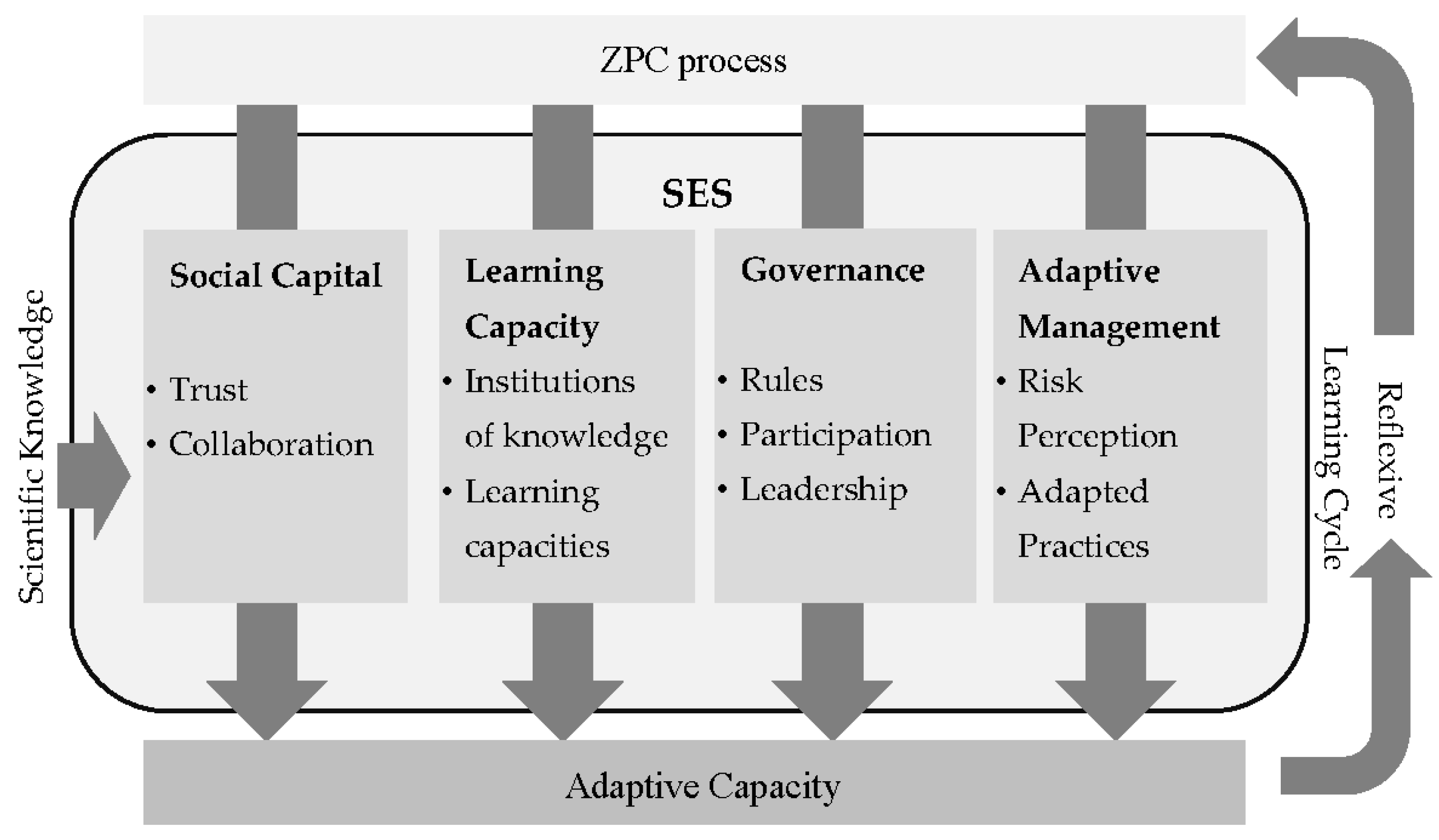
2.1. Theoretical Framework for Assessing Adaptive Capacity

Adaptive capacity of a SES is the ability of actors to achieve and sustain a resilient state of the system [22]. Resilience, in that context, is the capacity of a system to absorb disturbance and to adapt to change while sustaining the same functions, structure, identity and feedbacks, presuming the existence of multiple stable stages [6]. Therefore, resilience is an inherent condition of the adaptive capacity of a system [22,23,24]. Resilient SES have the ability to self-organize and learn to live with change and uncertainty, while integrating different types of knowledge and structured social networks to generate stable institutions and promote innovation [8,25,26]. Within this context, social resilience highlights the role of communities in developing adaptive capacities of the SES in the face of change [27]. Hence, we assume that the human component is the agent that builds adaptive capacity to transform the SES into a sustainable and resilient state space. Integrating different knowledge systems in this process can increase the understanding of the SES and thereby contribute to transforming the governance of the system towards sustainability [28]. By combining formalized governance networks with informal learning networks, reframing the discourse among actors and eventually transforming routines and practices add important dimensions to the learning process of governance systems [29]. While external knowledge-brokers can facilitate learning process building adaptive capacity, the legitimacy of knowledge exchange between actors depends on the establishment of “institutions of knowledge”; in other words, rules and values that define the way in which learning occurs [9,14]. These institutions for knowledge integration depend on social contexts, power relations, learning dynamics and political and institutional settings [30,31].
The adaptive capacity of SES is strongly linked to how social systems perceive their resilience towards change [22,32]. Lockwood et al. proposed a psychometric approach for assessing adaptive capacity in four dimensions: social capital, human/financial/physical capital, management approach and governance [32]. While the approach was developed from a vulnerability perspective, we reframe it to our resilience perspective assessing to what extent Shamboyacu communities perceive an improvement of their adaptive capacity due to the ZPC process. As the dimension of human, financial and physical capital were not visibly altered by the ZPC process, we decide to instead highlight the importance of the learning process, using the four dimensions: social capital, adaptive learning, adaptive management and governance (see Figure 4), which we define as follows.
Social capital refers to relations among persons, linked in networks of obligations and trust, reciprocity and exchanges, with underlying social norms, facilitating an action [32,33]. Accumulating social capital for sustainable development describes the process in which a group of agents (in this case a community) establish norms, as well as formal and informal relationships to coordinate interactions among themselves [34]. While increasing social capital does not automatically imply sustainability, it is seen as a structural prerequisite for enabling innovation for conservation as part of the local development strategy [35]. In our case study, social capital describes the development of trust by developing social procedures and rules by which the community itself regulates their activities. Throughout governance processes (in our case the ZPC process), the different stakeholders establish procedures for collaboration as a basis for joint activities and interaction.
Learning capacities are part of the social capital of a SES. They refer to the ability of learning to live with change and understanding change based on experience. In the presence of different knowledge epistemologies, it becomes necessary to address value systems and power relations that determine the production and implementation of knowledge [36]. One way to tackle this is by giving legitimacy to the learning and capacity building process through the existence of formalized arrangements enabling transparent and democratic participation of all relevant social actors [37]. In this regard, institutions of knowledge refer to procedures and norms that define the conditions for knowledge exchange [9].
For social learning, a high level of trust is necessary [12,37,38], as well as knowledge brokers to translate and foster the integration of different forms of knowledge [37]. Analysing learning capacities in this study evaluates the ability of communities to integrate knowledge from different origins into their planning processes and management decisions.
Governance describes the formal and informal institutional arrangements that orient and regulate resource use in a community. In the absence or weak implementation of external rules, it is up to local leaders to “self-organise effective rules to manage a resource” ([5], p. 419). Rules on managing resources have to be found to be effective, when they meet a set of general principles for robust governance of environmental resources that are implemented within local conditions and institutional settings [5,39]. Folke et al. also highlighted the importance of acknowledging the interlinkages between rules and the dynamically developing knowledge system [7].
Legitimacy and accountability of a governance system including its rules depend on an organised participation of community members [32]. Governance structures have to flexibly incorporate local interests in order to resolve possible conflicts and embrace perceptions or risks and uncertainties [39]. Adaptive governance has to continuously adapt to changing conditions of natural capital, which challenges accountability of institutions and collaboration [38,40]. It has to be taken into account that participation strongly depends on the cultural context and can lead to elitist structures and gender exclusion [41].
Effectively implementing governance structures and sustaining them throughout and after a project period requires local leadership [32]. Adaptive capacity requires leadership and institutions that support local social systems to develop local visions and facilitate changes [38,42]. Leadership measures to what extent local agents take opportunities to initiate action to change [7].
Adaptive management refers to the management of resources in the face of uncertainty [43,44]. Analysing adaptive management requires taking into account the balance between long-term and short-term needs, as well as the level of inclusion of stakeholders and their ability to adapt their practices in the face of change [10,45]. We therefore assess the perceived risks that guide local practices towards an increased perceived resilience [22]. This involves the identification of ecological uncertainties and risks regarding the functionality of ecosystems and confronting necessary adjustments of management practices and potential trade-offs that may arise [44].
As a second step, we assess to what extent the reflection of risks and changes has led to adapted practices. It is the continuous application and practical verification of knowledge generated during the ZPC process that enables the communities to adapt their management to shift their SES into a more sustainable state space.

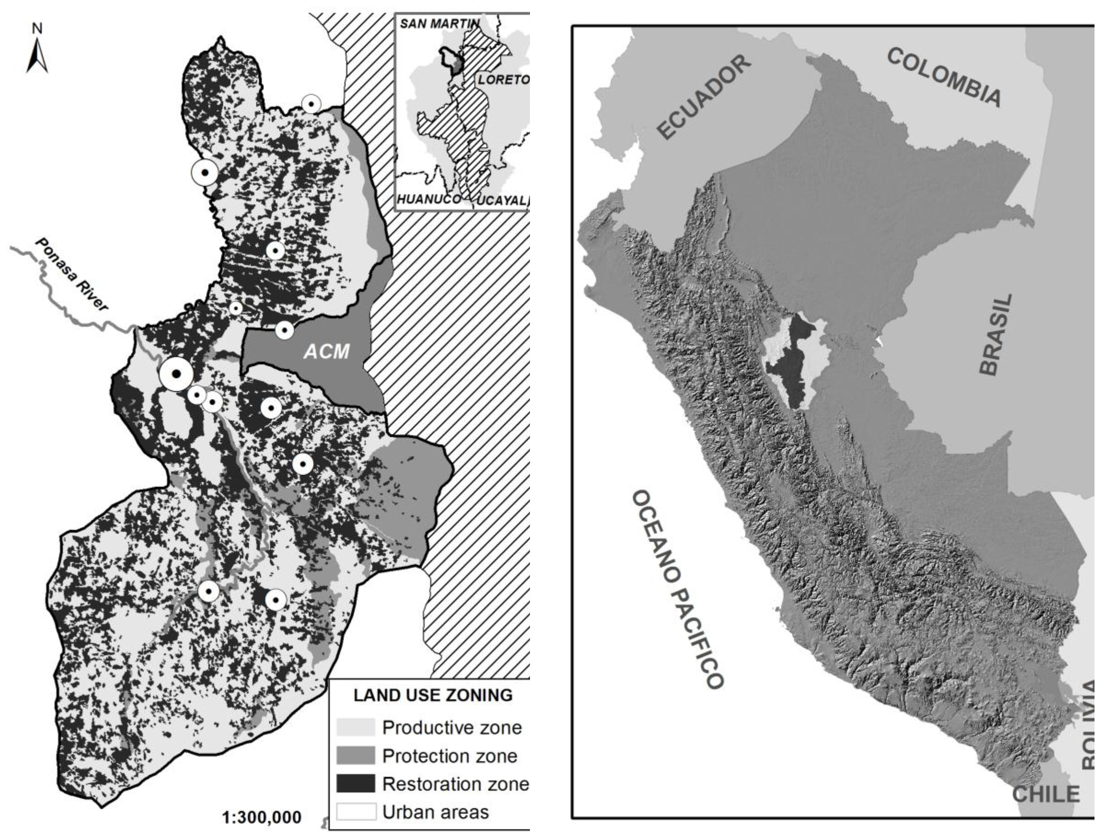
2.2. The Social-Ecological System: The Shamboyacu Sector in the Buffer Zone of Cordillera Azul National Park

Cordillera Azul National Park was established in 2001 over approximately 13,532 square kilometres with the aim to protect biological communities, headwaters and entire basins, characteristics of Cordillera Azul mountain range and to support the development of sustainable resource management of neighbouring areas, from the Huallaga to the Ucayali river. The buffer zone, of roughly 23,000 square kilometres, is home to approximately 520 towns and indigenous communities, most of whom are located on the western Huallaga side. In Peru, buffer zones are legally recognized areas around protected areas, in which the National Service of Protected Areas in Peru (SERNANP) must give favourable opinion in order to allow infrastructure, mining, oil or any other activity that may compromise the integrity of the protected area. Furthermore, the SERNANP team is entitled to monitor and control the buffer zone for the same purposes. In the buffer zone of Cordillera Azul, CIMA works more directly with the 75 communities that are closest to the park to minimize their impact on the park. The park stretches over four political departments of Peru: Loreto, Ucayali, Huanuco and San Martin. On the western side in San Martín, a road provides easy access to the buffer zone, where large shares of low mountain rainforest have been converted into agricultural land. By contrast, the eastern Ucayali side hosts a several indigenous communities and is still almost entirely covered with lowlands forests.
CIMA has been working in the Park since 2002 and is responsible for securing funding, technical staff and overall management. The Park administration is formally under a twenty-year co-management contract (2008–2028) between SERNANP and CIMA. SERNANP designates officials such as the park chief and Park guards, implementing mainly control functions, while CIMA executes overall management, monitoring and extension roles. SERNANP considers the park as the protected area with the least socio-environmental conflicts in Peru. One of CIMA’s main activities is capacity building processes in the buffer zone, such as ZPC and FOCAL (see Appendix A for an overview on FOCAL). Park management and activities in the buffer zone are since 2008 funded by a Reducing Emissions from Deforestation and Degradation (REDD+) project for avoided deforestation inside the park. In earlier years, CIMA was funded by charity donors and international cooperation (see acknowledgments).
In the analysis, we focus on the buffer zone within the district Shamboyacu, in the department of San Martín (Figure 3). Located in the upper reaches of the Ponasa basin, a tributary of the Huallaga River, the sector covers 26,732 hectares, originally covered by pre-montane rainforests ranging from 400 to near 1200 m a.s.l. The area is part of what has been recognized as Peruvian eastern Andean dry forests, in the Huallaga-Tarapoto region, containing around 35% of unique species of flora, including even the rare cactus Calymmanthium substerile [46]. The vegetation changes towards the park with the forest turning into pre-montane still contains some tree species of the adjacent dry-forest. In 2001, when the park was created, 25.7% of the Ponasa watershed had been converted into agriculture and by 2008, only 50.25% of the original forest was left. Rainfall has decreased from ~1400 mm in the 1980s, to ~1000 mm in the last years. The Shamboyacu sector analysed in this study comprises 12 rural communities. Nine communities with 732 families completed the ZPC process: Alto Ponaza, Chambira, Lejía, Paraíso, Simon Bolivar, Vista Alegre, as well as Alto Jorge Chavez, Nuevo Amazonas and Porvenir. Field research was conducted in the first six communities.
The communities, composed of as much as 57% of migrants, significantly contributing to an average of 8.2% annual population growth [47]. Migration occurred in waves following specific historical events [48]. Thus, most of the people living in the western region next to the park are first or second-generation migrants from the Andean hills. Yet, the population in these communities has doubled from 2005 to 2012, increasing from around 320 to over 765 families. In this paper, the term community refers to local populations in rural areas including small villages, officially called “centro poblado”, or a group of households, interconnected in some way and with a determined area. These are different from indigenous communities, which in Peru are entities recognized by the state associated to a territory.
Local communities have individual perceptions and expectations of a certain quality of life. In the case of Shamboyacu, almost all communities aim to have access to improved infrastructure, medical services and primary education (information taken from MUF surveys in the communities). Most of the Shamboyacu communities are located in forestry concession areas that were distributed in 2001. Thus, they are neither the legal land holders nor can they be entitled. Differences between households within the communities derive from diverging property sizes, ranging from 2 hectares (ha), for the more recently established and poorer and 40 ha for those who arrived first, in the early 1980s. Main activities include subsistence agriculture, from slash and burn practices, crops such as corn, coffee, cacao, banana and some pasture for cattle ranching. However, in the oldest communities, a slow but increasing use of natural products from the forest has been noted, which indicates an adaptation to the local environment [49].
The settlers have organized into communities, meeting in monthly communal assemblies where they take decisions. This reflects the Andean culture of taking decisions as a group [50]. Participation in assemblies is mandatory for each household. In the past, in some communities, absence from assemblies was physically punished; nowadays, penalties cost between half and a full day wage. Although all members of the community can take part in the assembly, only the “inhabitants”, designed according to internal rules (e.g., the male or female household head) can vote when decisions are made. For instance, in some cases only those which hold land (regardless of officially titles) can vote. Rules are approved through voting and are thereby institutionalized. When rules are violated and an informal solution of a conflict is not possible, it is the assembly that decides on the penalty. When this is not possible, the “ronda campesina” (voluntary peasant security rounds) intervenes. The Ronda is rooted in the ancient Inca traditions and evolved during colonial and republican times. It was historically sited in the Andean region and must therefore been introduced by the migrants. The Ronda functions as self-defence organisation for the protection of community property. The current form and name emerged during the 1970 [51,52]. Today, its general rules and moral codes are supported by a legal framework (law of Peasant Rounds N° 27908). As a recognized but non-governmental institution, the Ronda supports the implementation and enforcement process of community’ decisions.

2.3. Material and Methods

The results of this study are based on three types of information: an analysis of the documents produced throughout the ZPC and related processes, qualitative stakeholder interviews and deforestation as proxy for ecological change. CIMA documented the ZPC process, collected social information in communal surveys (MUF) in the years 2003, 2005, 2008 and 2012 and produced conceptual guidelines and insights generated by the ZPC processes from 2006 to 2011.

Selecting case study and interviewees

We used qualitative interviews to assess the four dimensions of adaptive capacity, as proposed in the theoretical background. The qualitative interviews were conducted with all participating actor groups between February 2013 and April 2014. Even though interviews were designed to be individuals, we conducted group interviews in several communities due to the articulated preference of community members. We interviewed representatives in each of the six communities Vista Alegre (4 individual interviews), Lejía (1 group interview, 1 individual interview), Alto Ponaza (1, 3), Paraíso (1, 2), Chambira (1, 1) and Simon Bolivar (1, 1). The six focus communities were selected as they were the first to finalise the ZPC process. Communal authorities (agente municipal and teniente gobernador) and a CIMA technical field person helped identifying communal leaders (as defined by the communities) to explain the social structure and management practices within each community. In addition to the members of the ZPC dialogue groups, the authors approached communal members external to the ZPC process. Although three women took part in the group interviews, they felt uncomfortable to participate in interviews as they are not used to speak on behalf of their families or their communities. Additionally, we interviewed nine representatives of the technical units of CIMA living and working in the communities and facilitating the ZPC processes. As additional stakeholders, eleven CIMA officials, the park director, two park rangers, the mayor of the district Shamboyacu and another civil servant, as well as the district president of the “Ronda Campesina” were interviewed. In total 43 interviews were conveyed, representing all stakeholder groups involved in the local land-use governance. Three of the authors are affiliated with CIMA but external to the ZPC process. All interviews were conducted by the independent author who has no affiliation to any involved actor group.

Analysing the interviews

In a semi-structured interview setting, we asked the interviewees about their role in the ZPC process and their experiences with the process and its outcome. They were asked about the selection process of contact groups, the role of the interviewees themselves, their perception of purpose and impact of the ZPC and how the ZPC product was used in community governance. Additionally, they were asked to describe their resource use and practices. They were asked for their habits, decisions and conflicts related to their land management, formal and informal rules that determine their resource use and how they relate to the use of the ZPC.
Applying content analysis [53], interviews were coded and utterances were linked to the four dimensions of the analytical framework. In an open coding procedure, we structured the coded statements along the dimensions and sub-dimensions of the framework to reconstruct meaning and structures that stakeholders attach to the ZPC processes. All interviewed individuals were treated as competent experts providing objective insights on the governance procedures and management practices within the communities. Applying the quality criteria of theoretical saturation [54], we challenged constructed meanings repeatedly with possible falsification until further interviews only supported the insights on adaptive capacity in the communities.

Analysing forest cover changes

For a complementary analysis of forest cover change, we use high resolution satellite data. We exploit the fact that the six studied communities were the first to complement the ZPC process. Therefore, we compare yearly forest losses between the studied communities and the remaining communities in the Shamboyacu district. We intersect the raster at a 30 m resolution with the community boundaries to estimate yearly forest clearings. Furthermore, we distinguish deforestation between the land-use zones developed by the ZPC (see Section 3.5). Furthermore, we calculate deforestation rates within each land-use zone developed by the ZPC and compare these between both groups of communities. The analysis is based on the word database on forest cover change from Hansen et al. (2013) and on the re-calibration to the Peruvian Amazon region by Potapov et al. (2014) [55,56]. The full Peruvian dataset is downloadable at geobosques.minam.gob.pe (see Appendix C for technical details).

3. Results

The ZPC essentially adopted a bottom-up approach to define and agree on a comprehensive land management strategy, based on adaptive management and the best available knowledge. The zoning process started in 2005; it was concluded and approved by the communities of Shamboyacu in 2010 and officially approved by the district municipality in 2013. The resulting main land-use classes are urban zone, productive zone, protection zone and restoration zone. The communities of Shamboyacu have decided to restore in the following years one third of the forest area for natural resource extraction and to increase protected areas by 5% points.

3.1 Social Capital

3.1.1 Building Trust among Stakeholders

In the early years of the park, inhabitants of the buffer zone of Cordillera Azul felt that they were restricted from freely entering the park and limited in their potential of expanding their lands. Interviewees reported that generating trust among stakeholders was especially important, given that CIMA and the park authorities had been regarded by the communities as intruders interested in restricting the communal life. Accordingly, important factors for building trust were the long-term presence of the NGO and being transparent about the objectives and adapting conservation activities to local structures:
The people realized that we were not a project that lasts two or three years and is only going to achieve one target […]. By contrast, our objective for all of our life is conservation and to integrate productive activities and our best allies here are the rural communities, the club of mothers, the committees of producers and others, with whom we have to work.
(Technical staff CIMA)
Central to the idea of collaboration is to constantly emphasize the actor’s role within the process, i.e., the community being the protagonist and the NGO providing technical support. Throughout participatory process that led to the development of the master plan of the park (A master plan is the official management plan of a protected area, approved by SERNANP and is reviewed every 5 years) the park administration and CIMA promoted the phrase: “we all are the park” (todos somos el parque) which served as a guiding principle. CIMA took the role of an initiator and facilitator to develop and implement each step. The technical staff, that lives in the communities for years clarified:
We observe that they themselves become aware of their communal reality and their responsibility [for their lands]. They realize that we do not bring schools, bridges, or other things to hand over. The work we do is training, raising awareness, support for management processes and technical advice on production.
(Technical staff CIMA)
Hence, CIMA representatives stated that they have openly indicated their interest in using the ZPC as capacity building process for sustainable land-use since the beginning of the process. At the same time, they were open to local needs of the communities, such as the interest in hunting in the park for self-consumption. As outcome of this process, the community developed ownership of the processes as demonstrated by in the following quote:
The NGO has helped us, because we are proud of conserving our forest without any reward.
(Community member Lejía)

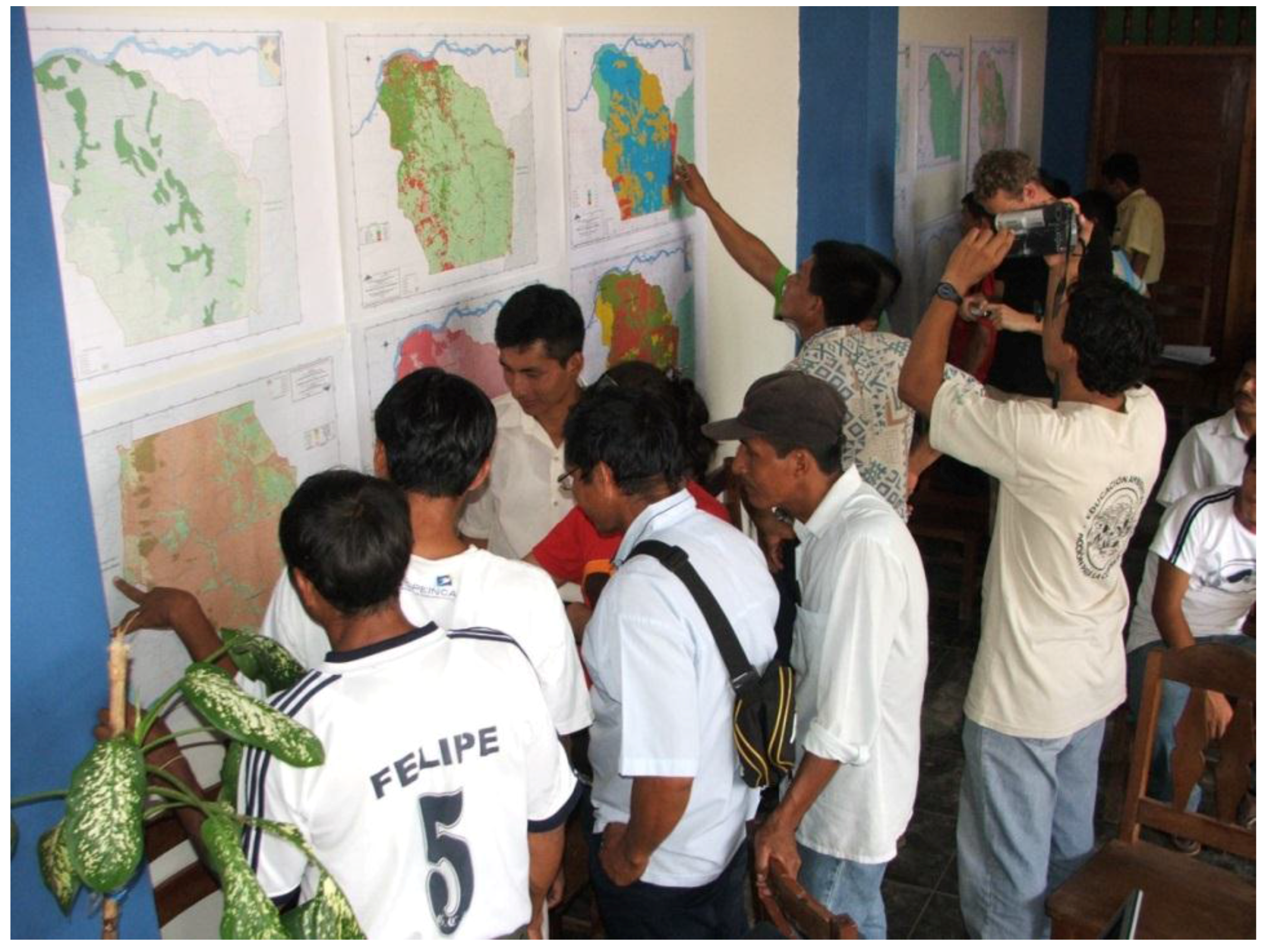
3.1.2. Collaboration in the ZPC Process

Assuming that all community members can contribute to ZPC, CIMA representatives highlight the importance of including and reflecting people’s perception on land-use, landscapes and natural resources. According to the stakeholder statements, getting to know each other and exchanging points of view helped to build trust in both, the ZPC and facilitators. This in turn was central for building a stable relationship. Community members identified the technical value of the ZPC as to where best to cultivate which crop and when. A community member from Alto Ponaza states:
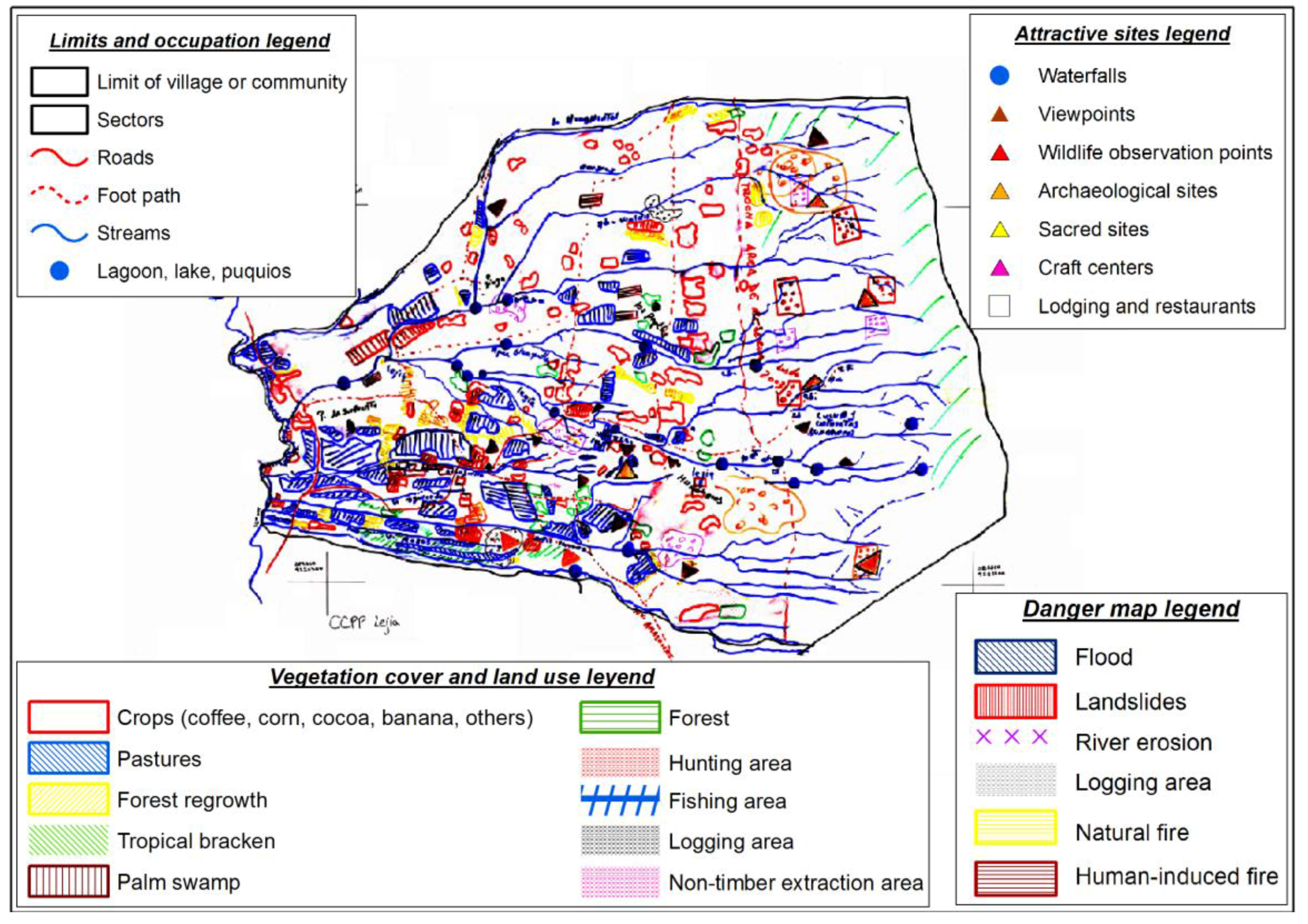
What I understand (from the ZPC map) is that it indicates where we have to saw trees where they have been lost.
In addition, the joint data collection in the field and the analytical deliberations during the analysis and reflection phase of the ZPC helped building trust. According to socio-economic surveys in the communities, jointly defining boundaries between communities played an essential role in reducing conflicts and raising respect of each other’s integrity. Finally, the process has also enabled communities to seek official recognition as “centros poblados” (villages) and the information and maps generated throughout the ZPC have helped to achieve that status. Realising the practical use of the instrument, such as in the legal recognition of the community has especially strengthened the social capital among NGO and communities, as this was the main gain for the communities, otherwise placed in a weak legal situation:
Today, the population acknowledges more the work we are doing, because all of the information we jointly generated, does already serve them. We always told them what was good for what and now it actually does serve for what it was meant for and that is the advantage.
(Technical staff CIMA)

3.2. Learning Capacities

The work of CIMA was guided by three overarching principles; capacity building through knowledge exchange, including and empowering local actors within their existing organizational structures, and, encouraging dialogue and reflection to settle conflicts and coordinate interests.

3.2.1. Developing Institutions of Knowledge

The ZPC process required the integration of scientific-technical knowledge and local knowledge and beliefs. This information was geographically linked to the communal areas and discussed together with all actors. As described above, scientific data from the technical reports made by consultants and existing scientific information on the area, was included into the mapping process. Maps generated from satellite images, geological soil analyses, forestry and other inventories, as well as recommendations from technical reports for land-uses were discussed with the community and integrated into the analysis (i.e., on erosion risks, water purification cycles and potential crops). When asked about the practical value of the information provided by the ZPC, community participants particularly pointed to aspects important for their daily practices. Technical staff complimented that these insights were gained by repeatedly testing and validating insights in practical trials. Additionally, they reported that inventories of traditionally used species and practices were collected, mapped and linked to present and planned uses. This setting displays how communities were the agents deciding, which information was valid for their resource management and could be inserted into formal governance processes.

3.2.2. Building Learning Capacities

The impact of forest losses and their associated ecological changes were illustrated with examples such as water availability for the communities or risk from landslides by placing crops in steep areas. These reported examples characterize the technical team as knowledge bridgers (moderators of the ZPC process) facilitating the introduction of external technical knowledge into the process. It was however the decision of the communal dialogue groups to link the knowledge to mapping procedures and to designate land-uses. When the result obtained corresponded to local knowledge, it was approved (by the communities and the technical team) and remained as an input for the construction of scenarios. Participants of dialogue groups recalled that whenever technical information did not match local information, they would review it (if necessary validate it through a field visit) in order to come to a decision. Interviewees recall cases in which the technical information was outdated, or diverged from the community’s experience. According to interviewees, this process allowed the emergence of a learning network between the NGO and the communities. The entire process strengthens the capabilities of the field team, the NGO staff and community members. At the end of the ZPC, local actors (those in the dialogue groups, mainly but not exclusively) had undergone sufficient training on technical and organizational issues to take ownership and promote the ZPC results and implementation. For instance, the field team contrasted technical information on soils with the characteristics of the landscape, which helped to learn how to interpret and apply new knowledge. Members of the field team explained to us, how the definition of a land-use implies certain management requirements. Communities have developed the knowledge to recognize unsustainable land uses and the skills to address and curb them. Moreover, the communities realized that their territories are limited and that the uses can be improved by combining different types of knowledge.
Due to technical advice, new possibilities for income generation, such as ecotourism amplified the economic portfolio. With the information from the ZPC process, as well as the establishment of nursery gardens in the villages, the communities could plan and start their own conservation or restoration projects, aiming to secure essential ecosystem functions such as water provision, erosion mitigation and pollination of agroforestry crops (e.g., cacao or café).

3.3. Governance

In the absence of enforcement of territorial policies, except for the park, it is the community that decides on the land-use and natural resources. The large migration to the Shamboyacu district led to conflicts over property rights, resource use, community boundaries and other land uses. An important component of local capacity building processes has been the establishment of mechanisms for self-organization (authorities, rules and sanctions) and conflict mediation within and among communities. ZPC was a key element in this process as it helped defining boundaries and regulating resource uses and was approved by the communities. After a history of boundary conflicts between Chambira and its neighbouring communities (as documented in the MUF), the former principal agent states:
There are no conflicts on community boundaries, not with Vista Alegre nor with Simón Bolívar. And not within the community either.
Further external stakeholders, such as the park guards, representing the national conservation agency SERNANP, local governments and CIMA accompanied the ZPC processes and discussed management options with community members. However, community members report that it is the competence of the assembly to take land-use decisions.
As already mentioned, the “peasant rounds” (rondas campesinas) play an important role when applying sanctions and deciding on conflict solutions but also in fostering healthy relationships within the community and enhancing community commons. Community members reported how Ronda representatives support authorities for the collection of evidence and opinions, in case of conflict. For instance, they are involved in protecting their communal forests, improving school facilities, enhancing honey production, organizing fish farming, or organizing joint activities between communities sharing a watershed. Such results already reduced conflicts and established clear boundaries or created synergies and a coordinated use of common-pool resources. An exception in conflict resolution mechanism is Chambira, an indigenous community, whose procedures for crime prosecution and conflict resolution is handled by the (regional) indigenous federation in Lamas.

3.3.1. Rules

While only some communities have communal areas for conservation or education, all used ZPC to define different land-uses within their private lands. Those rules are enforced as demonstrated by the principal agent in Vista Alegre states:
For example in our communal forest. In our assembly we have said that those are the limits and beyond those nobody is to enter here. If there are news that somebody has entered, we form a committee to verify trails and how it is. And that is how it ends. But until today were did not have to enforce this law.
The establishment of a joint working-plan to initiate the ZPC fixed the common rules and roles for the community and the NGO in the process, including the definition of limits to the intervention of the bridging institution. The distribution of tasks and the establishment of a time-schedule enhanced the collaboration. After the ZPC was completed, each community developed “community coexistence rules”, which included environmental aspects, in addition to social, political, cultural and economic aspects of community life. The communal assemblies approved this code of conduct, which consists of a collection of rules and sanctions that are internally valid for community. Community co-existence rules were designed in a step-wise process by a commission, designated by the community in a general assembly. As a first step, the commission identified authorities and its functions. Secondly, it identified issues and situations that had to be regulated. Examples include the development of a communal calendar for community celebrations, agreements on transportation, rules and sanctions regarding the respect of forested areas on mountain slopes and water sources. Other issues include the development and implementation of control measures and sanctions, or the establishment of a democratic election processes for community authorities.
“Coexistence rules” and “quality of life plans” are general formats that could be implemented according to internal structures of each community based on formats and methodologies developed by CIMA (see Table 1). Some communities adopted those procedures (Lejía, Alto Ponaza, Paraíso and Vista Alegre), while other communities preferred to develop mechanisms by themselves (Simón Bolívar, Chambira) here defined as “informal”. Furthermore, communities consolidate important land-use decisions and agreements in communal records (“actas”):
We also have our areas for conservation like those we have up on the hillside - a real quantity! The first people that came here [said], ‘we will not chop down until there is no more.’ They cut down an area and [said] ‘here we are going to work’ […] Based on this we developed some records that every person has to conserve the environment, [for example] in slopes and around water sources.
(Community member Lejía)

3.3.2. Participation

The community members have been involved in the management and conservation of the park from the beginning, working as either community rangers, participating in patrols or as communal surveillance for the park. All phases of the ZPC, from the preparation to the analysis and vision, were highly participatory and centred on communal needs. However, it was challenging for CIMA to hear the voices from all community members. Aside from the first three steps that went through general assemblies, the field visits during the second phase, provided the chance to broaden participation. A spatial validation and GIS data confirmation took place within the land of every community member. Improving equity and participation was nevertheless a task pursued by CIMA. During the latest MUF, conducted in 2016 to update the master plan, CIMA formed mixed groups (including women and children) to contrast their ideas of socio-economic status and potentials for development.
During dialogue group workshops, community leaders identified and tested the knowledge that was to be integrated into the ZPC. The leading authorities were the head of the community (agente municipal) and the governor of norms (teniente gobernador); both were elected almost yearly and were always part of those dialogue groups. They took care of the ZPC products by communicating them to local and regional governments. In contrast, some communal members that had not been part of the ZPC process (particularly women and young men) were not familiar with ZPC. In one case, the implementation of the ZPC was delayed due to a leadership change. The new head of the community had not been part of the dialogue group and did not consult the ZPC product, which remained with the former community leader. Mechanisms to ensure a wider participation in dialogue groups and transferring the product to new community authorities will have to be installed to avoid these problems.

3.3.3. Generating Leadership in Conservation Activities

The ZPC process has helped to understand the value of forest resources and benefits communities receive from functional ecosystems. Communities could strengthen their attachment to the land, as they were able to define community boundaries and reach official recognition into villages. On several occasions, interviewees emphasised that they are an “organised” community and that ZPC helps them to get a better overview on their lands and ecological and economic potentials.
Furthermore, these new concerns regarding the ecosystem have led communities to manage some areas as official conservation areas. A representative from Chambira states:
We are going to protect the environment and the water, because in time it will be gone
Interviewees reported that the official recognition motivated them to actively protect water bodies, headwaters, areas that serve as additional habitat for wildlife, important cultural, educational and social landscapes. For instance, a communal forest at El Porvenir (271 ha), a communal forest (34.5 ha) and a school forest (6 ha) at Vista Alegre have been added as local conservation areas. The latter was donated by the district to the school, which is managing it with its students. Chambira and Lejía are also developing conservation projects in their communal forests. Furthermore, increasing productivity in some parts of the communal area allows for other, particularly sensitive areas to be used for conservation. As an example, the people of Shamboyacu are now planting trees along water sources and mountain slopes to prevent erosion and floods. Additionally, communities mentioned the use of ZPC maps and products as references when initiating new projects with national authorities.

3.4. Adaptive Management

Reports and documentations of the ZPC process shown that maps helped to visualize combined knowledge, at the landscape scale and not only at the individual land plot. This allowed to develop a new perspective on land-use options (see Figure 2), that has resulted in effective changes on land-use patterns (see section on conservation outcomes below). Reflecting upon risks and management impacts on the ecosystem throughout the ZPC process led to the adoption of certain new practices.

3.4.1. Risk Perception

The ZPC includes a risk analysis during the “reflection” phase. It was designed to determine areas with the highest environmental risks. The in-depth reflexive analysis reviewed information on natural events such as flooding, landslides, soil erosion, water pollution, strong winds, strong rains, drought, as well as migration and deforestation activities. The technical staff states:
Throughout the ZPC we produce a historic timeline collecting information for the period of the last 20 years, describing floods, natural disasters, storms and all types of natural disasters that pose risks for the population.
(CIMA technical staff)
The risk analysis provided a better understanding of potentials and limitations of the ecosystem. Moreover, it helped to develop possible responses to changes in the SES. By working on visions and obstacles for uses of each resource in a matrix analysis, the communities learned to identify the ecological limits of the SES. This exercise led to an increase in adaptive capacity on how to cope with anticipated changes. For instance, as forests were perceived central for providing water, they identified lack of knowledge, technical advice and financial resources as main obstacles to sustain this ecological function.

3.4.2. Adapted Practices

The change in attitudes has started to reflect an increasingly sustainable use of the landscape. The development of a sense of ownership over the territory prevented many people to have unsustainable practices and abandon the land towards new frontiers, when the soil quality is impoverished. A member of the community Chambira indicated the valuable ecological characteristics of the landscape:
This part up here is not to be touched. [indicating the communal reserve]. We leave the water fountains [as they are].” “Mountain slopes are respected. We are an organized village. Everybody understands that it is not allowed to touch certain parts.
(Community member Paraíso)
Technical guidance and spatial knowledge on their territory, helped to accommodate these necessities while aiming at sustainable production and building socio-ecological resilience. For example, providing guidance on quality management in the cultivation of coffee and cacao helped slowing the spatial expansion for cultivation while aiming at higher yields, quality and market value. Extension services support communities in increasing productivity, developing management plans for the certification of products (e.g., organic coffee) and the organization of farmers in associations (i.e., for coffee, cocoa, honey and other commodities) to increase the economically added value while reducing resource use.

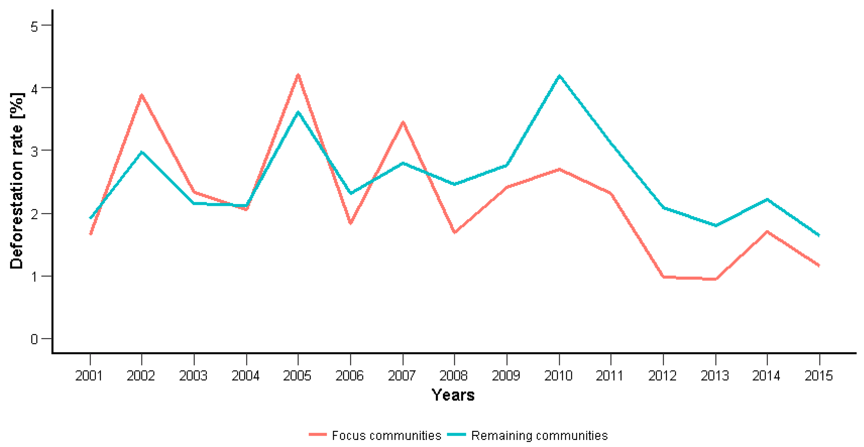
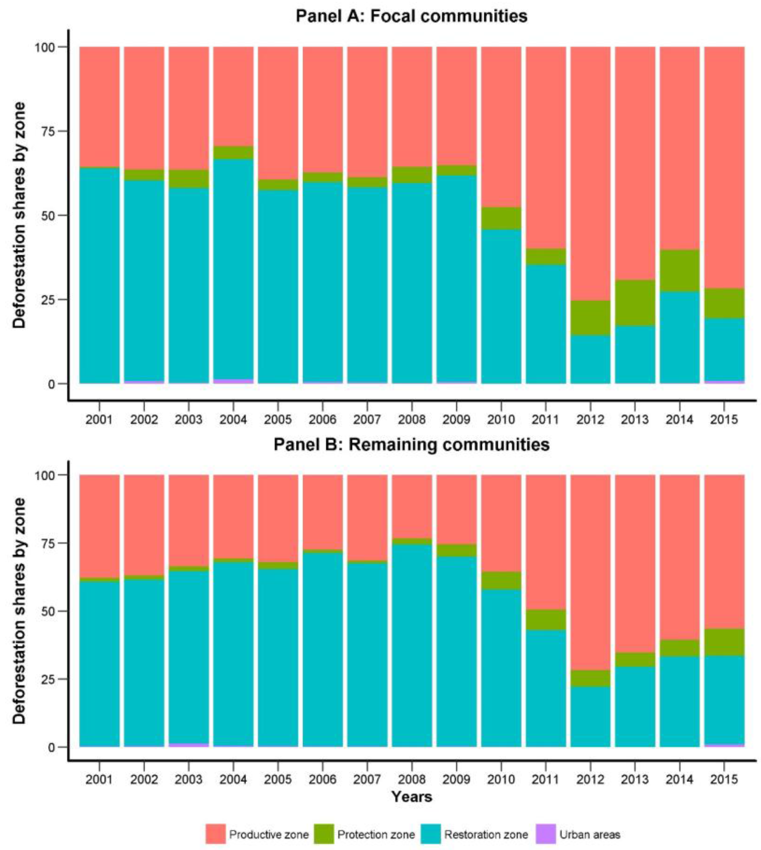
3.5. Short Term Conservation Outcomes

The field work and contentment analysis showed how the ZPC process transformed the environmental practices and understandings of inhabitants in the Shamboyacu district. We therefore expect these changes to have translated into a reduction of environmentally harmful activities. One objective measurement of a behavioural change and an indicator to environmental conditions is remotely sensed forest loss. We calculate the physical changes of forest cover in Shamboyacu (see Figure 3). At the beginning of our timeframe (2001–2015) the studied and remaining communities had 6.095 ha and 5.669 ha of standing forest respectively. This corresponds to 72% and 76% of the two groups territory. By 2015, the remaining forest cover had reduced sharply to 39% in the studied communities and 40% in the remaining communities.
The yearly development of deforestation rates is depicted in Figure 5. At first, it becomes evident that deforestation rates fluctuate between years. Yearly cloud coverage in the region explains most likely the fluctuation as it constitutes a measurement error, which delays the detection of cleared forest from one year to the next. Nonetheless, deforestation rates in both groups seem equal until 2007. After 2008 (when ZPC process started) deforestation rates dropped by 60% in the focus communities. This difference is statistically significant at a 10% level, after controlling for yearly effects.
In addition to forest losses we test for potential forest gains. Hansen et al. (2013) report forest gains between 2001 and 2012. Using this data, we find very low additional forest cover, only 52 ha (0.6% of the area) within the studied communities and 51 ha (0.6%) within the remaining communities.
As part of the ZPC process four different land-uses were distinguished. Spatial information on risks regarding flooding, landslides, soil erosion, water pollution and drought helped to decide on the distribution of the four land use zones (see Figure 6 and Table 2): urban zone, production zone, restoration zone and protection zone. The six studied communities designated 52% to production, 7%-points more than the remaining communities. In contrast, designated area for restauration dropped by 9%. Focus communities and remaining communities designated roughly similar shares of their land to conservation, accounting for 8% and 7%, respectively. These choices can be better understood when inspecting the remaining forest cover in 2008 when the zoning of the land areas concluded and the six studied communities finalized the ZPC process. Table 2 shows both the shares of the zones and the remaining forest cover in 2008. Protection zones have been largely untouched with 84–92% remaining forest cover. This indicates a commitment of both groups to preserve the ecologically valuable areas in the future.
By its nature, restoration zones are largely deforested and only have 28% or 39% of remaining forest cover. Productive zones on the other hand still have more than 65% or 70% of standing forest. It becomes clear that the designated shares to the four zones reflect both, the conservation status and the commitment to preservation. We therefore analyse if the patterns of deforestation in those areas (rather than the levels) changed over time. From the results of the in-depth qualitative analysis in the field we expect that the ZPC process led to a reduction in forest clearings within the ecologically valuable areas (restoration and protection).
Figure 6 shows the contribution of each zone to the total deforestation in each year, i.e., how much of the yearly deforestation fell into each zone. In both groups deforestation patterns seem to change after 2008. The six studied communities shifted deforestation away from restoration areas and reduced their share from 63 to 18% until 2015. In comparison, the remaining communities reduced their share only from 61 to 33% (Panel B). This is a solid change over time, though the difference between the two groups could reflect differences in remaining forest cover. Here, the lower forest cover in 2008 could explain the larger drop with the six communities. In parallel, the share in deforestation activities increases for the production zone, where both groups still have more than 65% forest cover. Finally, both groups continue to deforest small amounts within the designated protection zones and in both cases the share increases after 2008. It has to be taken into account that studied communities (Panel A) were closer connected the road network and the capital of Shamboyacu and therefore easier accessible. We assume that it is due to this accessibility that they were the first for being populated and began earlier to deforest the area.
In summary, deforestation rates seem to have reduced slightly, though yearly data is prone to strong measurement errors. Nonetheless, the studied communities seem to deforest consistently less after 2008. Regarding the classified zones, both groups of communities start off under similar conditions, with the exception of lower forest cover in the restoration zone for the studied communities. All communities change their deforestation patterns and shift deforestation activities away from their designated restoration zones into the productive zones. Although the six communities have experienced the full ZPC process, changes in deforestation patterns only differ by small amounts.

4. Discussion

4.1. Adaptive Capacity Depends on Effective Knowledge Integration

While the potential of contribution of protected areas and indigenous communities to forest conservation is well documented [2,57,58,59], our case study on the ZPC process shows that also newly established communities can develop and integrate conservation practices into their resource management. Our interviews detect that the ZPC process has led to advances in all four dimensions of adaptive capacity analysed in this paper. Accordingly, deforestation patterns in studied communities (see Panel A in Figure 6) and not studies ZPC communities (Panel B in Figure 6) shift their deforestation to productive areas while maintaining areas designated for protection due to their ecological value and location. Although, we cannot conclude a strict causal relation, this observed development points towards the intended goals of the ZPC process. Despite those achievements over the short period from 2008 to 2016, stabilising (and potentially reversing) the ongoing loss of forest and biodiversity and eventually transforming the SES into a truly sustainable state space will depend on the capacity to deal with a variety of threats to deforestation and biodiversity [3], especially future demographic and production patterns. In contrast to the finding for indigenous territories [11,58], we find that assigning property rights and managing migration are key to effective conservation.
A central factor for these changes was the development of social capital in the communities, as well as between them and external actors such as park guards and NGO staff. The development of trust is an important attribute for land use planning processes and long-term experiences of adaptive co-management [33,60]. In the case of Shamboyacu, trust could only be built by the long-term engagement of the NGO and the flexibility of the ZPC methodology to consider local structures and practices. Researchers emphasise that trust and social capital are not sufficient conditions for the development of sustainable practices, they are however necessary conditions to enable capacity building [34,35]. The analytical dialogue created by the ZPC provided information, enhancing the social capital and knowledge exchange that facilitated the adoption of sustainable resource management rules.
In a context of high deforestation pressure and accelerated migration, technical and scientific knowledge can complement local knowledge [61]. Findings of the ZPC support the relevance of networks for knowledge exchange and the complementarity of knowledge systems in building resilience [28,37]. Our findings support the hypothesis that integrating scientific and local knowledge enabled local communities to fill their knowledge gaps in dealing with uncertainties [14]. The four year ZPC process and the ongoing NGO engagement provided the structural setting for communities to test and validate the practical value of the developed “hybrid knowledge” as a means for improving their living conditions and ecosystem functions. While technical staff living in the communities has been providing extension service according to the community’s demands, it was the community that assumed ownership as the driving agent to develop and implement the ZPC.

4.2. Land Use Planning for Local Sustainable SES—Potential and Limitations of the ZPC Process

Land use planning in Peru is a process under development. The ZPC is helping local actors to agree on sustainable land uses and facilitates to create visions and the necessary institutions for resource management. By doing this, the farmers as individuals and the inhabitants as a community are taking an ecosystem-based approach (EBA) to cope with several changes, thus increasing their own adaptive capacity and general resilience. In this process, adaptive learning depends on the repeated reflexion and adaptation of social norms and governance mechanisms in feedback loops [29]. We observe that ZPC initiated an adaptation of governance structures and discourses, which Pahl-Wostl calls first and second learning loops [29]. However, adapting practices towards sustainably managing the SES will depend on communities (as social agents) acknowledging limits and thresholds of the system, as concluded by Walker et al. [22].
From the experience in Shamboyacu it can be learned that ZPC can be understood as a process which confronts communities with the biophysical consequences of their activities. This case study identified a three steps adaptive learning process. First, the knowledge—presented either by the community or by CIMA’s technical team—was incorporated into the participatory mapping process. During the process, participants refer to the “territorial vision” (as a vision for the landscape) and perceptions of ecosystem functions as important concepts for guiding knowledge exchange; also referred to as “boundary objects” in literature [62,63]. Secondly, the knowledge on ecosystem management as well as technical information on soils and other elements of the ecosystem were explicitly introduced into the process and reflected by community participants. Gained insights were tested and thereby complemented local knowledge for adaptive capacity. Thirdly, every community adapted ZPC processes according to their needs and internal structures. Our results thereby support the hypotheses that learning processes need to be adjusted to fit the local governance and power structures [30,31] and be demand driven [11,18] to be effective. Communities assumed ownership of the process as they realised that ZPC process offered them possibilities, such as providing the information for legally registering their private properties and communities (“centro poblado”) in order to apply for public services, applying for investment and conservation projects, identifying and managing risks or for developing management plans for production and certification schemes. The ZPC therefore supports communities in taking leadership and learning at every step of the process.
Building on existing hierarchies and governance mechanism can however support existing elitist structures and gender exclusion [37,41]. In our case, the man dominated assemblies selected community members to participate in the ZPC processes and women were largely excluded from capacity building and decision processes. While ZPC creates the opportunity for joint learning and debates, there is still unused potential for further improving the dialogue among participants and including minorities or individuals that usually would not express their views [64].
A remaining challenge is the up-scaling of the ZPC process. While the pilot study in Shamboyacu was based on the active presence of a technical expert per one or two communities, up-scaling will require the development of more cost-efficient processes. Possible opportunities could be the training of local teachers or park staff, or the involvement of successful communities as “ZPC ambassadors”. Additional, funding could be provided by conservation funds or indirectly by REDD+. REDD+ funded areas are reported to compete for land-use with agricultural production and to be often implemented in areas with scattered property rights among many stakeholders [58]; however, implementing a REDD+ project on this region has been discouraged [48]. A possible scenario is that additional carbon credits with reasonable time frames are transferred to the park in order to facilitate capacity building in its buffer zone to mediate possible threats.
A remaining challenging task for CIMA and other involved actors is to strengthen the link between ZPC and broader processes in order to build up resilience against higher level demographic and economic pressures. For instance, the regional government project PROCEJA, funded by the German development bank KfW, conducted a land-use planning process (ZEE on mesa level) in the province including Shamboyacu but refused to incorporate the ZPC product on its analysis because it was not required to frame it according to existing legal land-use regulations. Literature highlights the importance of the surrounding policy environment and economies that local SES are embedded in [38,64]. In this scenario, NGOs and extension organisations, such as CIMA can assume a bridging role facilitate the coordination with local and regional governments [18].

4.3. Limitations of Research Approach and Outlook

This article analyses to what extent the ZPC advances aspects that are related to adaptive capacity. This does however not guarantee that the analysed communal SES enter a sustainable, resilient state-space. A thorough analysis of the whole intervention model (FOCAL) developed by the NGO remains to be made. For instance, a deeper analysis of the development of internal power relations, the nature of the transposed and mixed governance structures, the development and evolution of the coexistence rules, are of high interest to measure the success of the model. The analysis is conducted at the community level, although it accounts for individual and organization attributes. After all, we believe that expert knowledge covers all views of all involved stakeholder groups. A larger representation of actors, e.g., in a quantitative study, as well as an analysis over a larger time period could validate generated hypothesis and monitor long-term impacts of the ZPC process (as was done in [11]).
Communal institutional arrangements for adaptive capacity of the Shamboyacu SES will most likely be challenged by external developments. As governance systems of SES are shaped by powerful actors from different political levels, smaller SES are nested in larger systems and can be overpowered by changes at higher scales; each scale following different governance arrangements and visions of progress and development [36]. In the absence of strong state regulation community land were observed as largely independent SES. In the process of growing economic and political interactions with larger scales also fostered by further immigration into the area and infrastructural development, resilience of SES has to be looked at in interdependence with interactions to other scales. Nesting institutional arrangements in multi-level governance structures on many layers helps producing a variety of policy strategies to target individual needs and the complexity of using different resources [39]. However, intentions of assessing and integrating social and ecological interests were shown to result in both conceptual challenges due to complex webs of interactions and even potentially conflicting tendencies [65].

5. Conclusions

ZPC is a novel tool that enables communities to reflect their land-use practices and to organize their communal SES. In this study, we have shown that this communal land-use planning process can enable migrant communities to build adaptive capacities and incorporate conservation into their land management and governance practices. Besides declining deforestation rates, we observe that communities shift their deforestation activities to areas designated for production during the ZPC process. Earlier studies have analysed the forms and holders of traditional knowledge and social memory, which is historically build in relation to a community environment [11,66,67,68]. The Shamboyacu case is about “knowledge translocation and adaptation” where communities are composed of a combination of cultures and a highly dynamic number of migrants. In the absence of a unified, traditionally grown knowledge base, the co-management approach has shown that migrant communities in Shamboyacu can still establish rules for resource use and build adaptive capacity in their strongly converted SES.
While the literature has emphasised the high potential of indigenous territories and natural protected areas in contributing to climate mitigation and adaptation, experiences with ZPC show that engaging in capacity building in non-indigenous communities with high levels of migration and cultural diversity can produce conservation outcomes outside of protected areas and thereby is an example for implementing the ecosystem approach [69]. Nevertheless, we see critical difficulties in supporting ZPC with climate finance mechanisms such as REDD+, due to dispersed and missing land tenure distributions with associated risks for ongoing deforestation. Instead, a more promising strategy will be reducing legal incentives for immigration into free forest areas, or at least redirecting migration into areas designated for agriculture.
The iterative steps of the ZPC (coupled with additional components of the FOCAL approach) constitute a group of participatory tools facilitating a deeper understanding of SES. The long-term engagement and continuous presence of the NGO was necessary for the communities to build trust and institutions of knowledge as a foundation of the collaborative learning process. Giving communities the opportunity to continuously test and validate the knowledge generated in the ZPC process as a resource for sustainable land-use innovation, incentivised ownership and leadership in implementation activities. The adaptive capacity and resilience of SES can be strengthened by the development and implementation of institutions when the process is adapted to the pace of communities and remains flexible to local governance structures.

Acknowledgments

The approach presented here is the result of a process initiated in 2003 by CIMA in collaboration with the Field Museum (TFM) of Chicago. Alaka Wali, Debra Moskovits and Daniel Brinkmeier (TFM) kindly contributed to the design of the ZPC approach, together with Miguel Macedo, William Llactayo and members of the field team of CIMA. Alex Reategui, Roxana Otárola and Raúl Tinoco contributed to different steps by handling GIS information. Throughout the ZPC process, CIMA Cordillera Azul received grants from USAID, directly and through the TFM and The Nature Conservancy; the Gordon & Betty Moore Foundation, the John D. and Catherine T. MacArthur Foundation and the Blue Moon Foundation. Miguel Vasquez, Roman Montilla Flores, Ramón del Aguila, Darwin Cordova, Jimmy Rios, Pedro Flores and Newton Saldaña were key to our understanding of the ZPC and FOCAL. We especially thank them along with the people from the communities from Shamboyacu, for their willingness to share their views and knowledge of the area and the approach. Yves Zinngrebe’s work was funded by Heinrich Boell Stiftung. Lily Rodriguez thanks Diane Sietz and Guiseppe Feola for the motivation to write this paper. We thank Selina Bruns and Jennifer Hauck for their constructive comments. We acknowledge the support of the Open Access Publication Fund provided by Göttingen University and the German Research Foundation.

Author Contributions

Lily O. Rodriguez and Yves Zinngrebe jointly developed the analytical framework, designed the methodological approach and wrote the paper. Lily O. Rodriguez provided background information on the socio-political and ecological context of the Shamboyacu area. Elías Cisneros designed and analysed land-use changes and deforestation. Tatiana Pequeño provided the technical information on the ZPC process and CIMA interventions. Maria T. Fuentes provided deforestation data and analyses. Yves Zinngrebe conducted and analysed the interviews.

Conflicts of Interest

The authors declare no conflict of interest.

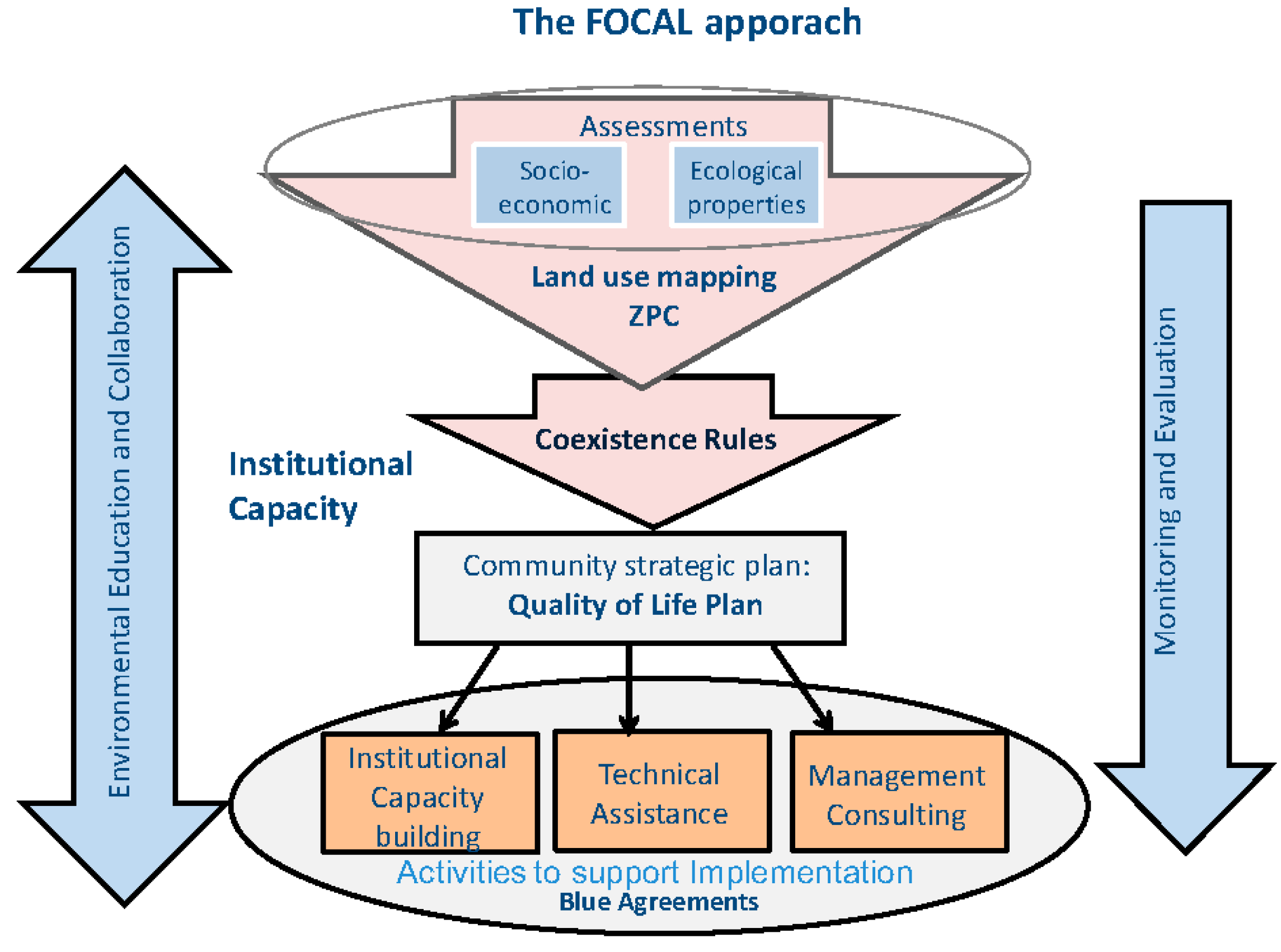
Appendix A. The FOCAL Approach Developed by CIMA

The FOCAL approach (Spanish translation for “Strengthening Local Capacity for Conservation”) consists of different analytical, planning and implementation components (see Figure A1, see online information for more details on FOCAL: http://cima.org.pe/es/nuestra-gestion/fortalecimiento). Additional to the Participatory Communal Land Use Plan (ZPC), there is the development of Coexistence Rules (Normas de Convivencia), usually formulated after or parallel to the ZPC, once the ecological and social contexts are well known and are followed by a Quality of Life Plan (Planes de calidad de vida), which is a strategic plan for the community. The ZPC identifies the potentials and limitations of the territory that are essential for the community development. Based on that information, CIMA also facilitates the implementation of the Quality of Life plans, taking into account other existing local and regional plans for development and the special condition of being located in a buffer zone of a national park. After having developed the ZPC, Coexistence Rules and the strategic plans, some communities have signed a Blue Agreement (Acuerdos Azules) or conservation agreement with the NGO, as a way to formalize and ensure adherence to the commitments and cooperation among parties. The agreements are documents signed between CIMA and the communities, witnessed by the National Park authorities. At present, four of the ten communities included in this study have completed FOCAL and are implementing sustainable activities such as improving cocoa and coffee crops in agroforestry systems, or the establishment of associations to manage the forest, generating benefits and improving their quality of life.
Figure A1. Overview on the different tools of the FOCAL approach.
Sustainability 10 00511 g0a1

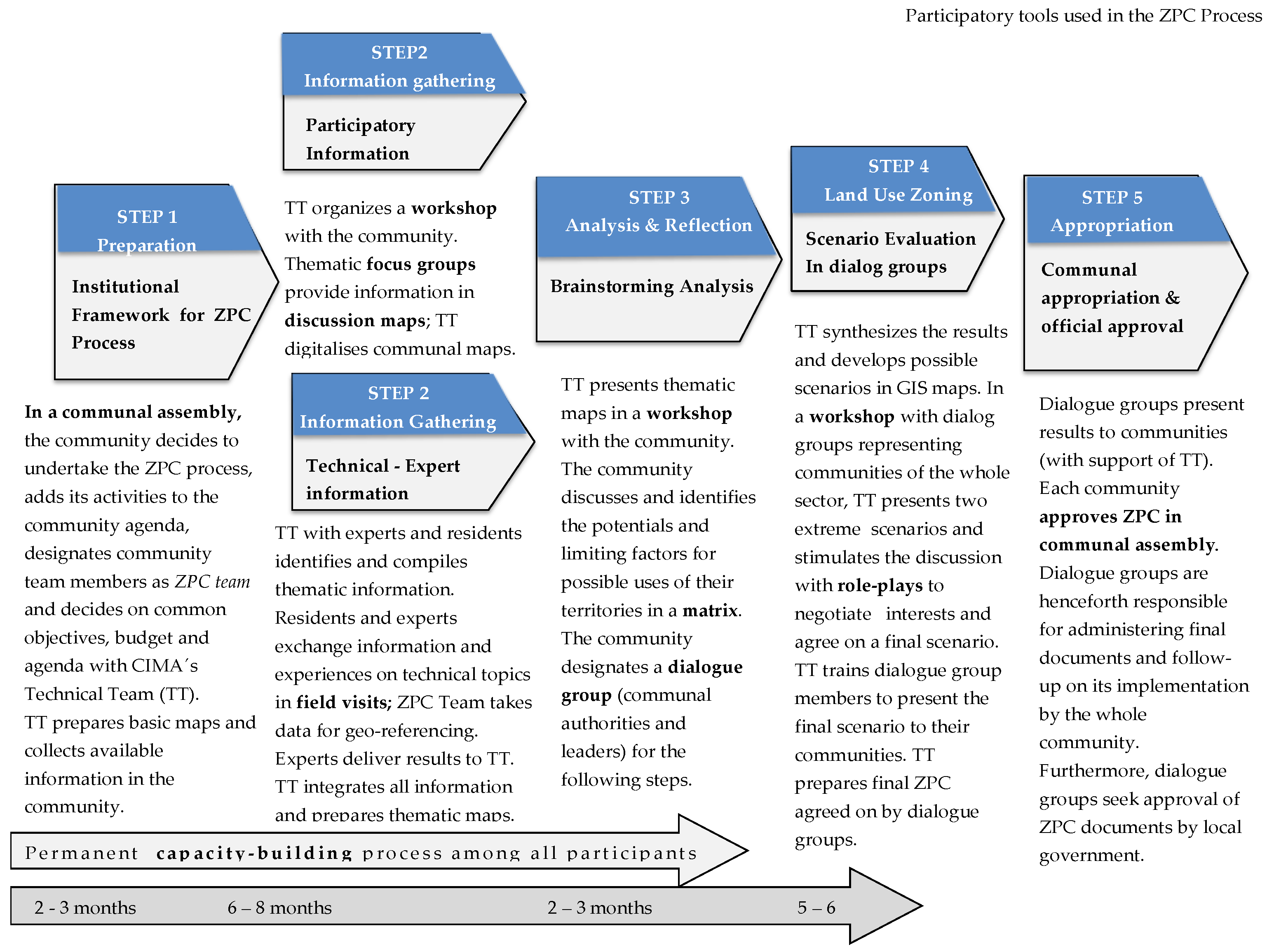
Appendix B. Supplementary Information on ZPC Process

Appendix B.1. Regulatory Context for ZPC (as Implemented by CIMA)

The development of the ZPC methodology is strongly linked to the regulatory framework of ecological-economic zoning (ZEE; see Figure A2). ZEE was developed as an alternative approach to the agro-ecological zoning and as a type of zoning which integrates physical land resources elements with socio-economic factors and a wider range of land uses in zone definitions (FAO, 1996). In Peru, the land use planning should be supported by two consecutive processes: the ZEE and the territorial management (OT). Conceptually, the ZEE is the tool to generate diagnostic information. In turn, OT is meant to be a decision-making process, subsequent to a ZEE and with and several additional studies, in which future uses of the land are defined upon agreement with the stakeholders involved. However, only ZEE is officially recognized by national and regional (department) authorities; and only recently, the municipal levels have been granted decision-making powers in the zoning process, as part of the decentralization of authority that is being implemented in the country. Thus, so far, no territorial classification (OT) has officially been put in place. Additionally, the national agency for civil defence (INDECI), has produced guidelines to undertake risk assessments, following basically the “natural hazard approach” [26] and definitions made by UNESCO (Environment and Development Briefs—Disaster Reduction 1993) and UNDRO (1980). This framework was taken into account when designing the ZPC.
Figure A2. Technical process of land use zoning, according to national regulations, as modified by CIMA.
Sustainability 10 00511 g0a2

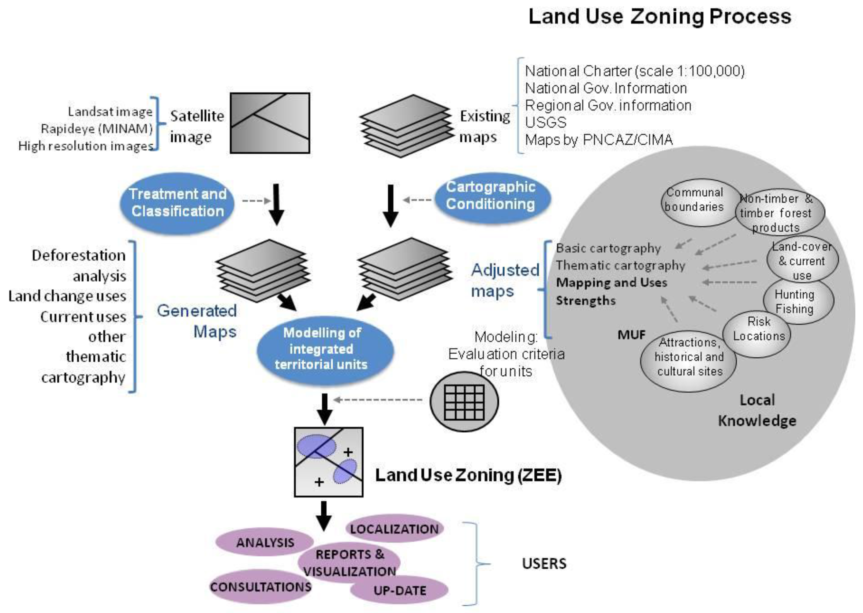
Appendix B.2. Description of the ZPC

Phase 1 Preparation: Provides the institutional frameworks for the development of the process. The ZPC theme is introduced to the communal agenda by presenting it in a communal assembly, so as to gain general interest, commitment and agreements of key stakeholders to actively participate in the process. Then, the community designates its facilitators to be part of the ZPC team and agrees on a work plan with objectives, scope, timelines and budget. The team is therefore composed by communal facilitators; technical support from CIMA and specialists (consultants). At the same time, secondary information on the study area is researched by specialists and technical staff to build the database.
Phase 2 Information gathering: Generates data on territorial aspects (physical, biological and socio-economic) of the communities. The mechanisms for sharing and combining knowledge among the technical team, consultants and the local population are applied precisely in this moment. This phase has two stages:
(a) Gathering participatory information: Collects local knowledge on aspects of the territory and the use of resources such as wildlife, timber and non-timber forest resources, water, soil for agriculture and agroforestry and environmental issues and risks (i.e., vulnerable areas for floods and landslides, reduced flow and water quality due to forest loss and poor agricultural practices) during a workshop. Working over GIS maps, the community develops talking maps, organized in focal groups by subject of expertise. They also perform a geographical reconnaissance of the major environmental physical features of their area, providing a local topology of areas of occupation and activities (see Figure 2).
Talking Maps are enriched with: (1) information provided through questionnaires and other tools coming from the Uses and Assets Mapping (Mapeo de Usos y Fortalezas—MUF, CIMA 2014, GIZ, 2012) and (2) field visits, where special attributes of the natural landscape (i.e., zones with potential for visiting) as well as attributes generated by human interventions such as field crops and paths, geographical boundaries, coverage and current use, areas of risks and natural events are verified and georeferenced. MUF information also provides data on organizations and non-official leaders of communities that can be effective for the implementation of the ZPC. The technical team and specialists doing specific technical-scientific surveys (see below) participated in those same field visits, to obtain and exchange information directly from the community.
(b) Survey of technical-scientific information: Specialized technical evaluations were necessary to evaluate and integrate the main themes of interest: forest, soils, tourism, risks. This stage also took into account socio-economic specific data gathered through the MUF, which were coupled with the ZPC physical-environmental information. Studies were conducted by the technical team, supported by consultants (i.e., a soil scientist, a biologist and an agronomist in the case of Shamboyacu) to generate the primary data used to update, adjust, validate and enrich the thematic information for the ZPC. By doing field work, this team visited some of the householders and interviewed then about specific aspects of uses and changes in the land use. An interview was made to the family that has arrived first to the area to learn about the history of hazards in the area.
Phase 3 Analysis and reflection: In a specific workshop and through brainstorming analysis in a double entry matrix (see Table A1 as a reference) with each community balanced the potential of the resource (forest, water, soil, wildlife), the vision they have for the use of those resources and the obstacles or limitations to achieve that vision. Among the obstacles and limitations to the vision, the result of the risk assessment as well as their own assets and limitations were taken into account. Historical information on land cover and population growth was presented at this time (see Figure A3).
Dialogue groups are selected by the community in the same meeting, among the most active members in the process and those committed to providing continuity. Usually leaders of the communities were selected to be part of these groups. These dialogue groups represented the communities in the final steps of the ZPC. To perform their roles, they were supported by the technical team and a capacity building process was put in place by the NGO—to strength the capacities of the groups for interpretation, application and implementation of the ZPC—and promote coordination mechanisms to articulate it with other planning documents (i.e., existing District development plans, land-use planning at higher level and scale).
Phase 4 Land Use Zoning: Is a two steps phase. After the technical team prepared the thematic maps and summarized the information a “technical modelling workshop”, where only the technical team and consultants participated. There were produced the zone models for production, ecological, risk, restoration and urban aptitude. Those maps were presented and analysed with the dialogue groups in the second step, the “battle of maps” workshop. For that meeting, the technical team developed the analysis and modelling using GIS to produce two extreme scenarios, one fully oriented to conservation purposes and the second one totally oriented to production (mainly agriculture). In the workshop with the dialogue groups of all the communities from the whole Shamboyacu area, the technical team presented these scenarios and stimulated the discussion among all the participants, with role-plays with two main groups, one for each scenario. Pro and contra of each scenario were discussed and after negotiating interests among participants, a final decision was made, in a concerted proposal scenario for the land use zoning.
Following this workshop, the NGO prepared the final version of the ZPC. Then the technical team continued working on the enhancement of the capacities among dialogue group members for them to present the final scenario in their communities.
Phase 5 Approval and appropriation of the land use zoning results: The final agreed scenario was presented to each community by the respective dialogue group, with support of the technical team, in a communal assembly. After discussing the proposal and some minor amendments, each community approved the ZPC. The dialogue groups continued then working on the follow-up of the process. First step was to seek official approval, from the local government (district). Once it was approved, the dialogue group promoted it to get attention from other actors to contribute in the implementation of activities.
Figure A3. Participants to the workshop in the brainstorming analysis, phase 3.
Sustainability 10 00511 g0a3
Table A1. For each of the four of land use categories, certain activities are either recommended, recommended with restrictions or not recommended. Uses code is as follows: 1 Annual crops; 2 Perennial monoculture; 3 Ranching (cattle); 4 Timber for self-consumption; 5 Commercial timber; 6 Non-timber forest products; 7 Agroforestry; 8 Agrosilvipasture; 9 Self-consumption fisheries; 10 Commercial fishing; 11 Extensive aquaculture; 12 Tourism; 13 Mining; 14 Conservation; 15 Reforestation; 16 Subsistence hunting; 17 Research; 18 Road infrastructure; 19 Industrial/urban infrastructure; 20 Oil activity.
Higher CategoriesEcological-Economic ZonesRecommended UsesType of Vegetation (*)%
ProductionAnnual/mono-culture crops1T0.00
Permanent crops2,3,4,5,6,7,8,12,13,14,15,16,17T4.15
Forestry4,5,6,7,12,14,15,16 y 17N43.70
Protection & ConservationProtection zones12,14,15 y 17N11.07
Conservation zones12,14,15 y 17N4.63
RestorationFor protection and conservation12,14,15 y 17T4.50
For forestry production4,5,6,12,14,15,17T31.50
UrbanHuman settlements12,14,15,17,18T0.47
(*) Type of vegetation denotes actual coverage: N = areas with natural original vegetation (forest) cover; T = areas of secondary forest or different vegetation.

Appendix C. Technical Details on Deforestation Analysis

Figure 5 shows the yearly forest cover losses in the studied community and the remaining groups. Deforestation rates in both groups seem equally fluctuating until 2007. We test with a simple regression analysis, if the studied communities on average have lower deforestation rates than the remaining communities, which have not finalized the ZPC process. We run an OLS regression on yearly deforestation:
D i t =   + γ t + δ   S i + β   S i × P o s t 2007 t + ϵ i t
D, denotes the mean deforestation in year t in group i (either studied or remaining communities) γ t represents yearly time dummies which control for yearly effects, such as common trends and fluctuations. S i is a dummy variable indicating if the observation belongs to the studied community group. P o s t 2007 t is a dummy turning one for all years 2008 to 2015. ϵ i t denotes the remaining unexplained variation. Of interest is the coefficient β which shows by how much both groups differ after 2007. The estimation results show a significant coefficient of −0.92, which is statistically significant on a 10% level. The value means a 60% lower deforestation level between 2008 and 2015 in the studied communities compared to the remaining communities ( e 0.92 1 = 0.6 ). The Peruvian data set is downloadable at geobosques.minam.gob.pe. These newly available high-resolution (30 m) forest cover data sets are now widely used to identify drives of deforestation worldwide (e.g., [70,71,72].

References

  1. Phillips, O.L.; Aragão, L.E.; Lewis, S.L.; Fisher, J.B.; Lloyd, J.; López-González, G.; Malhi, Y.; Monteagudo, A.; Peacock, J.; Quesada, C.A.; et al. Drought sensitivity of the Amazon rainforest. Science 2009, 323, 1344–1347. [Google Scholar] [CrossRef] [PubMed] [Green Version]
  2. Oliveira, P.J.; Asner, G.P.; Knapp, D.E.; Almeyda, A.; Galván-Gildemeister, R.; Keene, S.; Raybin, R.F.; Smith, R.S. Lan-Use Allocation Protects the Peruvian Amazon. Science 2007, 317, 1233–1236. [Google Scholar] [CrossRef] [PubMed]
  3. Zinngrebe, Y. Learning from local knowledge in Peru—Ideas for more effective biodiversity conservation. J. Nat. Conserv. 2016, 32, 10–21. [Google Scholar] [CrossRef]
  4. Berkes, F.; Folke, C. (Eds.) Linking Social and Ecological Systems: Management Practices and Social Mechanisms for Building Resilience; Cambridge University Press: Cambridge, UK, 1998. [Google Scholar]
  5. Ostrom, E.A. General framework for analyzing sustainability of social-ecological systems. Science 2009, 325, 419–422. [Google Scholar] [CrossRef] [PubMed]
  6. Walker, B.; Holling, C.S.; Carpenter, S.R.; Kinzig, A. Resilience, adaptability and transformability in social–ecological systems. Ecol. Soc. 2004, 9, 5. [Google Scholar] [CrossRef]
  7. Folke, C.; Hahn, T.; Olsson, P.; Norberg, J. Adaptive Governance of Social-Ecological Systems. Annu. Rev. Environ. Resour. 2005, 30, 441–473. [Google Scholar] [CrossRef]
  8. Walker, B.; Carpenter, S.; Anderies, J.; Abel, N.; Cumming, G.; Janssen, M.; Lebel, L.; Norberg, J.; Peterson, G.; Pritchard, R. Resilience Management in Socio-ecological Systems: A Working Hypothesis for a participatory approach. Conserv. Ecol. 2002, 6, 14. [Google Scholar] [CrossRef]
  9. Davidson-Hunt, I.; Berkes, F. Learning as you journey: Anishinaabe perception of social-ecological environments and adaptive learning. Conserv. Ecol. 2003, 8, 5. [Google Scholar] [CrossRef]
  10. Chapin, F.S. Managing Ecosystems Sustainability: The Key Role of Resilience. In Principles of Ecosystem Stewardship; Folke, C., Kofinas, G.P., Chapin, F.S., Eds.; Springer: New York, NY, USA, 2009. [Google Scholar]
  11. Van Vleet, E.; Bray, D.B.; Durán, E. Knowing but not knowing: Systematic conservation planning and community conservation in the Sierra Norte of Oaxaca, Mexico. Land Use Policy 2016, 59, 504–515. [Google Scholar] [CrossRef]
  12. Davidson-Hunt, I. Adaptive learning networks: Developing resource management knowledge through social learning forums. Hum. Ecol. 2006, 34, 593–614. [Google Scholar] [CrossRef]
  13. Boillat, S.; Berkes, F. Perception and interpretation of climate change among Quechua farmers of Bolivia: Indigenous knowledge as a resource for adaptive capacity. Ecol. Soc. 2013, 18, 21. [Google Scholar] [CrossRef]
  14. Bohensky, E.; Maru, Y. Indigenous Knowledge, Science, and Resilience: What have we learned from a decade of international literature on “integration”? Ecol. Soc. 2011, 16, 6. [Google Scholar] [CrossRef]
  15. Hughes, R.; Flintan, F. Integrating Conservation and Development Experience: A Review and Bibliography of the ICDP Literature; International Institute for Environment and Development: London, UK, 2001. [Google Scholar]
  16. Bauch, S.C.; Sills, E.O.; Pattanayak, S.K. Have we managed to integrate conservation and development? ICDP impacts in the Brazilian Amazon. World Dev. 2014, 64, S135–S148. [Google Scholar] [CrossRef]
  17. Brooks, J.S.; Franzen, M.A.; Holmes, C.M.; Grote, M.N.; Mulder, M.B. Testing hypotheses for the success of different conservation strategies. Conserv. Boil. 2006, 20, 1528–1538. [Google Scholar] [CrossRef] [PubMed]
  18. Ozor, N.; Cynthia, N. The role of extension in agricultural adaptation to climate change in Enugu State, Nigeria. J. Agric. Ext. Rural Dev. 2011, 3, 42–50. [Google Scholar]
  19. CIMA. FOCAL: Modelo Para el Fortalecimiento de Capacidades Locales para la Gestión del Territorio y la Mejora de la Calidad de Vida; Centro de Conservación, Investigación y Manejo de Áreas Naturales (CIMA)—Cordillera Azul: Lima, Peru, 2013. [Google Scholar]
  20. CIMA. Guía MUF. Mapeo de 5 Usos y Fortalezas; Centro de Conservación, Investigación y Manejo de Áreas Naturales (CIMA)—Cordillera Azul: Lima, Peru, 2014. [Google Scholar]
  21. GIZ. Land-use Planning in Peru: Connecting People and Resources. In Land-Use Planning: Concepts, Tools and Applications; Annex A3; GIZ/BMZ: Berlin, Germnay, 2012; pp. 240–246. [Google Scholar]
  22. Walker, B.; Gunderson, L.H.; Kinzig, A.P.; Folke, C.; Carpenter, S.R.; Schultz, L. A handful of heuristics and some propositions for understanding resilience in social-ecological systems. Ecol. Soc. 2006, 11, 13. [Google Scholar] [CrossRef]
  23. Gallopin, G.C. Linkages between vulnerability, resilience, and adaptive capacity. Glob. Environ. Chang. 2006, 16, 293–303. [Google Scholar] [CrossRef]
  24. Engle, N.E. Adaptive capacity and its assessment. Glob. Environ. Chang. 2011, 21, 647–656. [Google Scholar] [CrossRef]
  25. Carpenter, S.R.; Walker, B.; Anderies, M.J.; Abel, N. From metaphor to measurement: Resilience of what to what? Ecosystems 2001, 4, 765–781. [Google Scholar] [CrossRef]
  26. Adger, W.N. Vulnerability. Glob. Environ. Chang. 2006, 16, 268–281. [Google Scholar] [CrossRef]
  27. Cote, M.; Nightingale, A. Resilience thinking meets social theory: Situating social change in socio-ecological systems (SES) research. Prog. Hum. Geogr. 2012, 36, 475–489. [Google Scholar] [CrossRef]
  28. Tengö, M.; Brondizio, E.; Elmqvist, T.; Malmer, P.; Spierenburg, M. Connecting Diverse Knowledge Systems for Enhanced Ecosystem Governance: The Multiple Evidence Base Approach. AMBIO 2014, 43, 579–591. [Google Scholar] [CrossRef] [PubMed] [Green Version]
  29. Pahl-Wostl, C. A conceptual framework for analysing adaptive capacity and multi-levellearning processes in resource governance regimes. Glob. Environ. Chang. 2009, 19, 354–365. [Google Scholar] [CrossRef]
  30. Moller, H.; Berkes, F.; Lyver, P.; Kisalioglu, M. Combining Science and Traditional Ecological Knowledge: Monitoring Populations for Co-Management. Ecol. Soc. 2004, 9, 2. [Google Scholar] [CrossRef]
  31. Bohensky, E.; Butler, J.; Davies, J. Integrating indigenous ecological knowledge and science in natural resource management: Perspectives from Australia. Ecol. Soc. 2013, 18, 20. [Google Scholar] [CrossRef]
  32. Lockwood, M.; Raymond, C.M.; Oczkowski, E.; Morrison, M. Measuring the dimensions of adaptive capacity: A psychometric approach. Ecol. Soc. 2015, 20, 37. [Google Scholar] [CrossRef]
  33. Pretty, J. Social capital and the collective management of resources. Science 2003, 302, 1912–1915. [Google Scholar] [CrossRef] [PubMed]
  34. Pretty, J.; Smith, D. Social capital in biodiversity conservation and management. Conserv. Biol. 2004, 18, 631–638. [Google Scholar] [CrossRef]
  35. Ostrom, E. Revising theory in light of experimental findings. J. Econ. Behav. Organ. 2010, 73, 68–72. [Google Scholar] [CrossRef]
  36. Yates, J.S. Uneven Interventions and the scalar politics of governing livelihood adaptation in rural Nepal. Glob. Environ. Chang. 2012, 22, 537–546. [Google Scholar] [CrossRef]
  37. Berkes, F. Evolution of co-management: Role of knowledge generation, bridging organizations and social learning. J. Environ. Manag. 2009, 90, 1692–1702. [Google Scholar] [CrossRef] [PubMed]
  38. Gupta, J.; Termeer, C.; Klostermann, J.; Meijerink, S.; van den Brink, M.; Jong, P.; Nooteboom, S.; Bergsma, E. The adaptive capacity wheel: A method to assess the inherent characteristics of institutions to enable the adaptive capacity of society. Environ. Sci. Policy 2010, 13, 459–471. [Google Scholar] [CrossRef] [Green Version]
  39. Dietz, T.; Ostrom, E.; Stern, P.C. The struggle to govern the commons. Science 2003, 302, 1907–1912. [Google Scholar] [CrossRef] [PubMed]
  40. Schutz, L.; Folke, C.; Österblom, H.; Olsson, P. Adaptive governance, ecosystem management, and natural capital. Proc. Natl. Acad. Sci. USA 2015, 112, 7369–7374. [Google Scholar] [CrossRef] [PubMed]
  41. Méndez-López, M.E.; García-Frapolli, E.; Pritchard, D.J.; González, M.C.S.; Ruiz-Mallén, I.; Porter-Bolland, L.; Reyes-Garcia, V. Local participation in biodiversity conservation initiatives: A comparative analysis of different models in South East Mexico. J. Environ. Manag. 2014, 145, 321–329. [Google Scholar] [CrossRef] [PubMed]
  42. Plummer, R.; Armitage, D. Integrating perspectives on adaptive capacity and environmental governance. In Adaptive Capacity and Environmental Governance; Springer: Berlin/Heidelberg, Germany, 2010; pp. 1–19. [Google Scholar]
  43. Holling, C.S. Resilience and stability of ecological systems. Annu. Rev. Ecol. Syst. 1973, 4, 1–23. [Google Scholar] [CrossRef]
  44. Rist, L.; Felton, A.; Samuelsson, L.; Sandström, C.; Rosvall, O. A new paradigm for adaptive management. Ecol. Soc. 2013, 18, 63. [Google Scholar] [CrossRef]
  45. Christensen, N.L.; Bartuska, A.M.; Brown, J.H.; Carpenter, S.; D’Antonio, C.; Francis, R.; Franklin, J.F.; MacMahon, J.A.; Noss, R.F.; Parsons, D.J.; et al. The report of the Ecological Society of America committee on the scientific basis for ecosystem management. Ecol. Appl. 1996, 6, 665–691. [Google Scholar] [CrossRef]
  46. Linares-Palomino, R.; Oliveira-Filho, A.T.; Pennington, R.T. Neotropical seasonally dry forests: Diversity, endemism, and biogeography of woody plants. In Seasonally Dry Tropical Forests: Ecology and Conservation; Dirzo, R., Mooney, H., Ceballos, G., Young, H., Eds.; Island Press/Center for Resource Economics: Washington, DC, USA, 2011; pp. 3–21. [Google Scholar]
  47. SERNANP. Parque Nacional Cordillera Azul. Diagnóstico del proceso de actualización del Plan Maestro; Servicio Nacional de Áreas Naturales Protegidas por el Estado (SERNANP): Lima, Peru, 2012. [Google Scholar]
  48. Holland, T.G.; Coomes, O.T.; Robinson, B.E. Evolving frontier land markets and the opportunity cost of sparing forests in western Amazonia. Land Use Policy 2016, 58, 456–471. [Google Scholar] [CrossRef]
  49. Gavin, M.C.; Anderson, G.J. Socio-economic predictors of forest use values in the Peruvian Amazon: A potential tool for biodiversity conservation. Ecol. Econ. 2007, 60, 752–762. [Google Scholar] [CrossRef]
  50. Mayer, E. The Articulated Peasant: Household Economies in the Andes; Westview Press: Boulder, CO, USA, 2001. [Google Scholar]
  51. Gitlitz, J.; Rojas, T. Peasant Vigilant Committees in Northern Peru. J. Latin Am. Stud. 1983, 15, 163–197. [Google Scholar] [CrossRef]
  52. Nuñez Palomino, G. The rise of the Rondas Campesinas in Peru. J. Legal Plur. Unoff. Law 1996, 28, 111–123. [Google Scholar] [CrossRef]
  53. Mayring, P. Qualitative Content Analysis: Theoretical Foundation, Basic Procedures and Software Solution; Leipniz-Institut for Social Science: Klagenfurt, Austria, 2014. [Google Scholar]
  54. Glaser, B.G.; Strauss, A.L. The Discovery of Grounded Theory. Strategies for Qualitative Research; Routledge: Piscataway, NJ, USA, 2012. [Google Scholar]
  55. Hansen, M.C.; Potapov, P.V.; Moore, R.; Hancher, M.; Turubanova, S.; Tyukavina, A.; Thau, D.; Stehman, S.V.; Goetz, S.J.; Loveland, T.R.; et al. High-resolution global maps of 21st-century forest cover change. Science 2013, 342, 850–853. [Google Scholar] [CrossRef] [PubMed]
  56. Potapov, P.V.; Dempewolf, J.; Talero, Y.; Hansen, M.C.; Stehman, S.V.; Vargas, C.; Rojas, E.J.; Castillo, D.; Mendoza, E.; Calderón, A.; et al. National satellite-based humid tropical forest change assessment in Peru in support of REDD+ implementation. Environ. Res. Lett. 2014, 9, 124012. [Google Scholar] [CrossRef]
  57. Nelson, A.; Chomitz, K.M. Effectiveness of strict vs. multiple use protected areas in reducing tropical forest fires: A global analysis using matching methods. PLoS ONE 2011, 6, E22722. [Google Scholar] [CrossRef] [PubMed]
  58. Walker, W.; Baccini, A.; Schwartzman, S.; Ríos, S.; Oliveira-Miranda, M.A.; Augusto, C.; Romero Ruiz, M.; Soria Arrasco, S.; Ricardo, B.; Smith, R.; et al. Forest carbon in Amazonia: The unrecognized contribution of indigenous territories and protected natural areas. Carbon Manag. 2014, 5, 479–485. [Google Scholar] [CrossRef]
  59. Nolte, C.; Agrawal, A.; Silvius, K.M.; Soares-Filho, B.S. Governance regime and location influence avoided deforestation success of protected areas in the Brazilian Amazon. Proc. Natl. Acad. Sci. USA 2013, 110, 4956–4961. [Google Scholar] [CrossRef] [PubMed]
  60. Gockel, C.; Gray, L.C. Integrating conservation and development in the Peruvian Amazon. Ecol. Soc. 2009, 14, 11. [Google Scholar] [CrossRef]
  61. Huggel, C.; Scheel, M.; Albrecht, F.; Andres, N.; Calanca, P.; Jurt, C.; Khabarov, N.; Mira-Salama, D.; Rohrer, M.; Salzmann, N. A framework for the science contribution in climate adaptation: Experiences from science-policy processes in the Andes. Environ. Sci. Policy 2015, 47, 80–94. [Google Scholar] [CrossRef]
  62. Bieling, C.; Plieninger, T. (Eds.) Resilience and the Cultural Landscape: Understanding and Managing Change in Human-Shaped Environments; Cambridge University Press: Cambridge, UK, 2012. [Google Scholar]
  63. Schleyer, C.; Lux, A.; Mehring, M.; Görg, C. Ecosystem services as a boundary concept: Arguments from social ecology. Sustainability 2017, 9, 1107. [Google Scholar] [CrossRef]
  64. Mercer, J.; Kelman, I.; Lloyd, K.; Suchet-Pearson, S. Participatory research for disaster reduction. Area 2008, 40, 172–183. [Google Scholar] [CrossRef]
  65. Linstädter, A.; Kuhn, A.; Naumann, C.; Rasch, S.; Sandhage-Hofmann, A.; Amelung, W.; Jordaan, J.; Du Preez, C.; Bollig, M. Assessing the resilience of a real-world social-ecological system: Lessons from a multidisciplinary evaluation of a South African pastoral system. Ecology and Society 2016, 21, 35. [Google Scholar] [CrossRef]
  66. Lasage, R.; Muis, S.; Sardella, C.S.E.; van Drunen, M.A.; Verburg, P.H.; Aerts, J.C.J.H. Vulnerability to climate change and community based adaptation in the Peruvian Andes, a stepwise approach. Sustainability 2015, 7, 1742–1773. [Google Scholar] [CrossRef]
  67. Montoya, M.; Young, K.R. Sustainability of natural resource use for an Amazonian indigenous group. Reg. Environ. Chang. 2013, 13, 1273–1286. [Google Scholar] [CrossRef]
  68. Marquardt, K.; Salomonsson, L.; Geber, U. Farmers facing rapid agricultural land condition changes in two villages in the Upper Amazon, Peru: Can action learning contribute to resilience? Int. J. Agric. Resour. Gov. Ecol. 2009, 8, 457–483. [Google Scholar] [CrossRef]
  69. Pequeño, S.T.; Fernandez-Dávila, M.P. Parque Nacional Cordillera Azul: Construyendo un Modelo de Gestión Integral en Áreas Protegidas. In En: Planificación y Gestión de Áreas Protegidas en América del Sur: Avances en la Aplicación del Enfoque Ecosistémico; Casavecchia, C., Lobo Peredo, A., Arguedas Mora, S., Eds.; UICN: Quito, Ecuador, 2014. [Google Scholar]
  70. Nepstad, D.; McGrath, D.; Stickler, C.; Alencar, A.; Azevedo, A.; Swette, B.; Bezerra1, T.; DiGiano, M.; Shimada, J.; Seroa da Motta, R.; et al. Slowing Amazon deforestation through public policy and interventions in beef and soy supply chains. Science 2014, 344, 1118–1123. [Google Scholar] [CrossRef] [PubMed]
  71. Carrasco, L.R.; Webb, E.L.; Symes, W.S.; Koh, L.P.; Sodhi, N.S. Global economic trade-offs between wild nature and tropical agriculture. PLoS Boil. 2017, 15, e2001657. [Google Scholar] [CrossRef] [PubMed]
  72. Nolte, C.; de Waroux, Y.L.P.; Munger, J.; Reis, T.N.; Lambin, E.F. Conditions influencing the adoption of effective anti-deforestation policies in South America’s commodity frontiers. Glob. Environ. Chang. 2017, 43, 1–14. [Google Scholar] [CrossRef]
Figure 1. Steps of Participative Community Zoning (ZPC) process applied to communities around Cordillera Azul National Park and its main participatory tools. The ZPC team, composed of members of the technical team from the NGO and people from the community, is established during the first step.
Sustainability 10 00511 g001
Figure 2. Local knowledge mapping. An example of the product obtained working with the population of Lejía.
Sustainability 10 00511 g002
Figure 3. The left map shows the Land-use zoning of Shamboyacu obtained by applying ZPC. Size of towns is presented according to number of inhabitants. The small map indicates the location of Shamboyacu in the buffer zone. ACM is a municipal protected area, still conserving the original vegetation and now being claimed as territory by indigenous people. The right map outlines the location of Cordillera Azul National Park in Peru (dark grey) and its buffer zone (lighter area).
Sustainability 10 00511 g003
Figure 4. Conceptual framework for developing adaptive capacity in communities at the buffer zone of Cordillera Azul NP. While scientific knowledge comes as an input from outside the SES, local knowledge is inherent part of the SES and is reflected and inserted into a continuous learning cycle.
Sustainability 10 00511 g004
Figure 5. Yearly deforestation rates over the total land area are calculated based on Potapov et al. forest cover classification by satellite imagery [56].
Sustainability 10 00511 g005
Figure 6. Panel A and B show the shares of deforestation contributions among the four zones in the study area. Panel A summarizes the six studied communities and Panel B the remaining communities. Before 2008, in both groups deforestation activities were most located (more than 50%) within restoration zones. After 2008 deforestation activities shifted towards productive zones with up to 75% of total yearly deforestation.
Sustainability 10 00511 g006
Table 1. Institutional capacities for conservation as developed by the studied communities.
Duration of ZPC ProcessCoexistence Rules (Adoption)Conservation ProjectsQuality of Life Plans (Adoption)
Simon Bolívar2006–2011InformalIndividualInformal
Chambira2006–2011InformalCommunal Forestinformal
Lejía2006–2011Formal (2013)Communal ForestFormal (2014)
Alto Ponaza2006–2011Formal (2013)IndividualFormal (2014)
Paraíso2006–2011Formal (2013)IndividualFormal (2014)
Vista Alegre2006–2011Formal (2013)Communal Forest and School ForestFormal (2014)
Table 2. Both focus communities and other communities with a developed ZPC have designated parts of their territory as urban, productive, restoration and protection zones. The table indicates the share of the overall community area dedicated to each of the zones as well as their respective forest cover in 2008.
ZoneUrbanProductiveRestorationProtection
Studied CommunitiesShare of total area [%]1.252388
Forest cover in 2008 [%]6652884
Remaining communities in ShamboyacuShare of total area [%]0.445477
Forest cover in 2008 [%]50703992

