Analysis of Changes in Land Use Patterns Pursuant to the Conversion of Agricultural Land to Non-Agricultural Use in the Context of the Sustainable Development of the Malopolska Region


Abstract
:1. Introduction
- -
- determining the size of land converted to non-agricultural use,
- -
- determining the directions of changes in the use of land converted to non-agricultural use,
- -
- determining the quality classes of land converted to non-agricultural use.
2. Materials and Methods
2.1. Materials for the Analysis
2.2. Research Methods—Taxonomic Analysis as a Tool for Regionalisation
3. Results
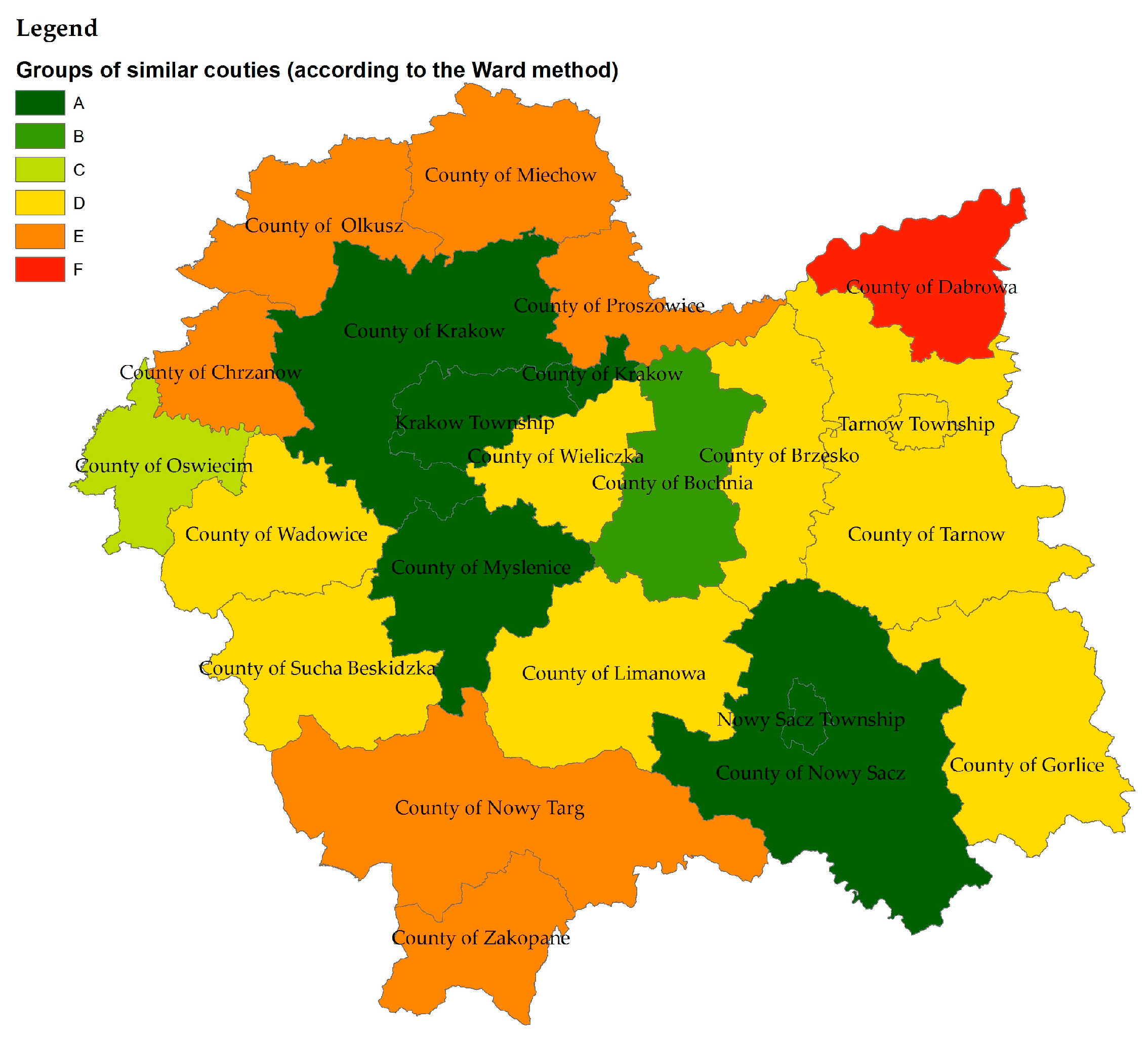
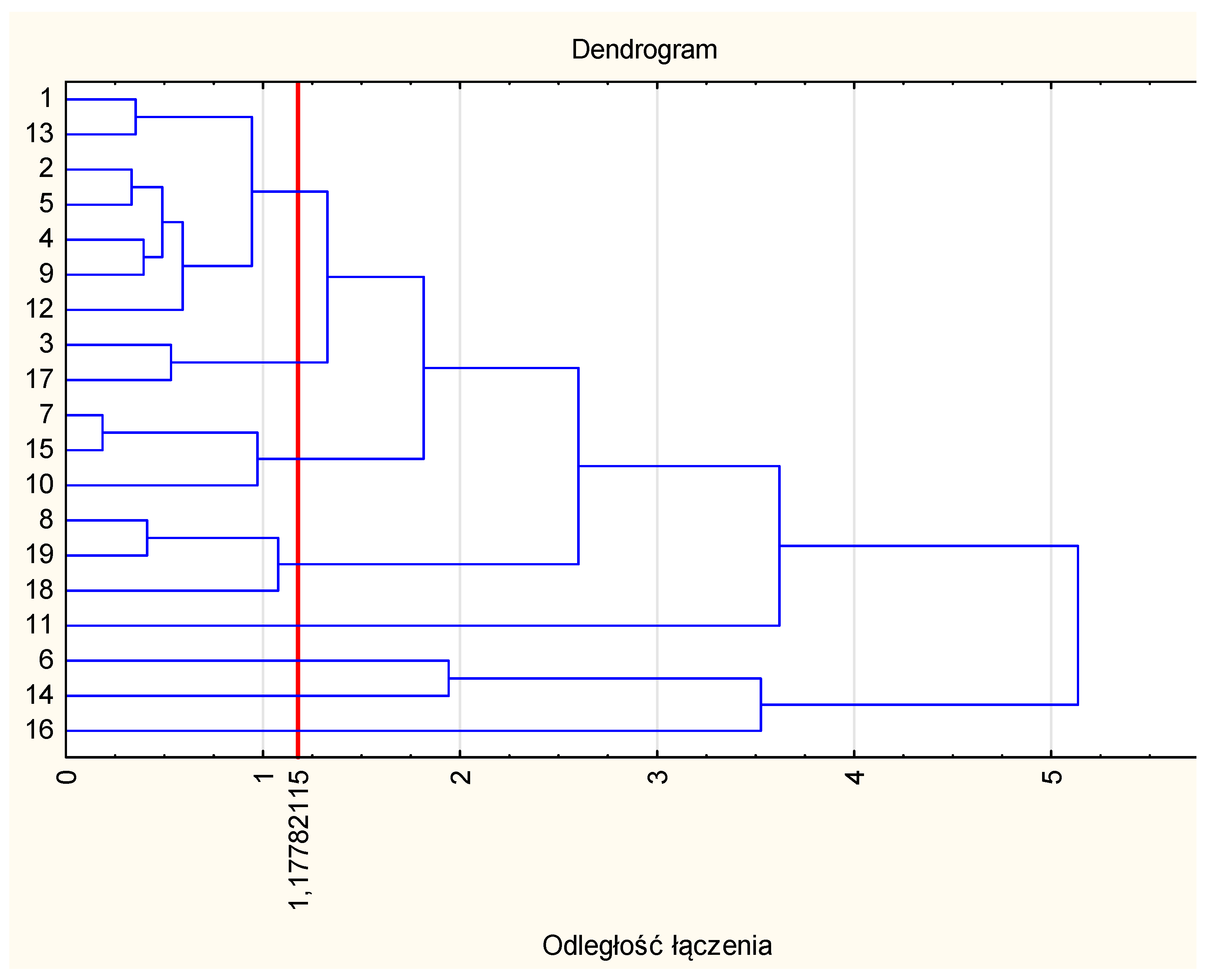
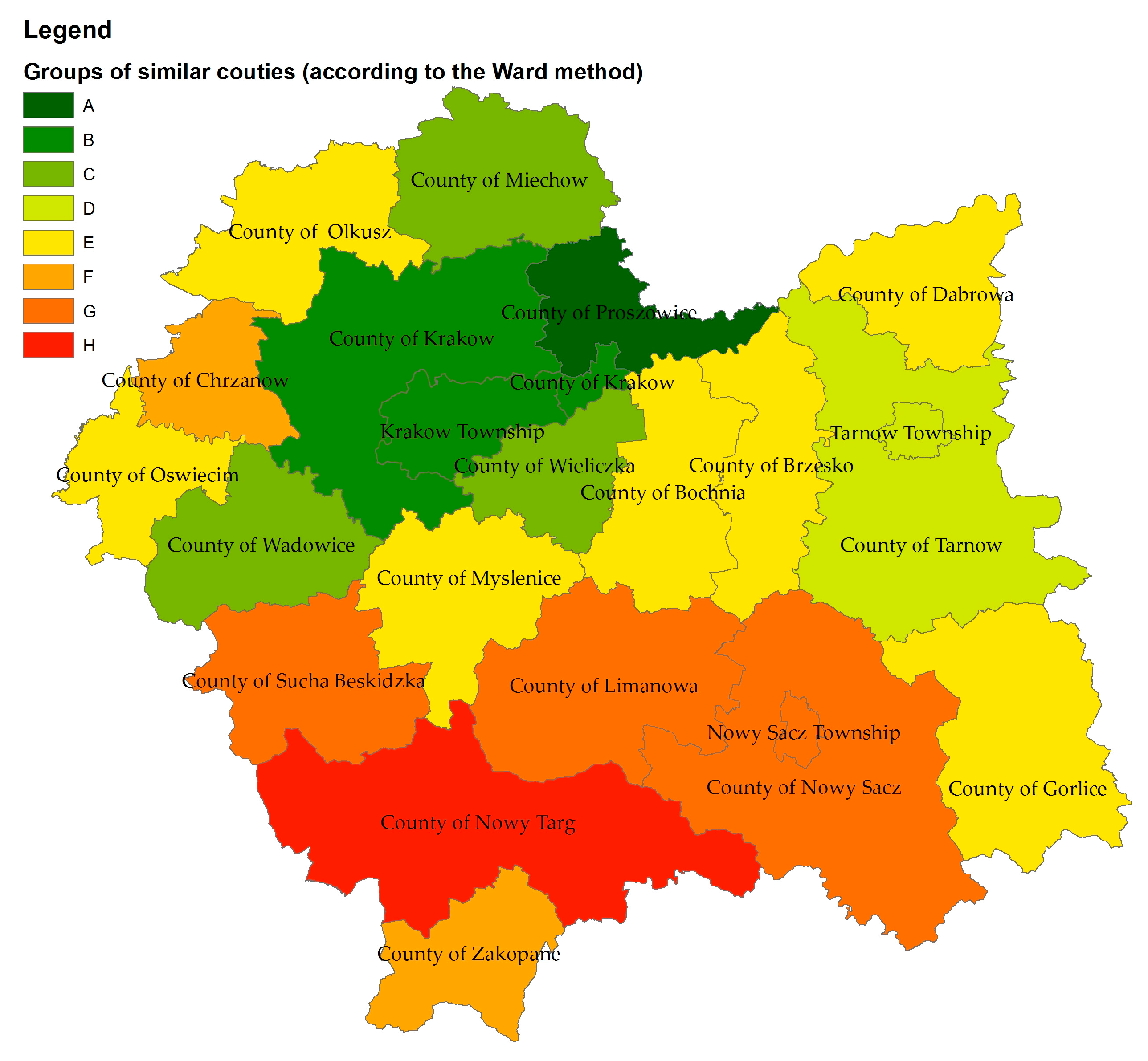
3.1. Groups of Counties Similar in Terms of Quality of the Soils at the Initial Stage of the Research (2010)
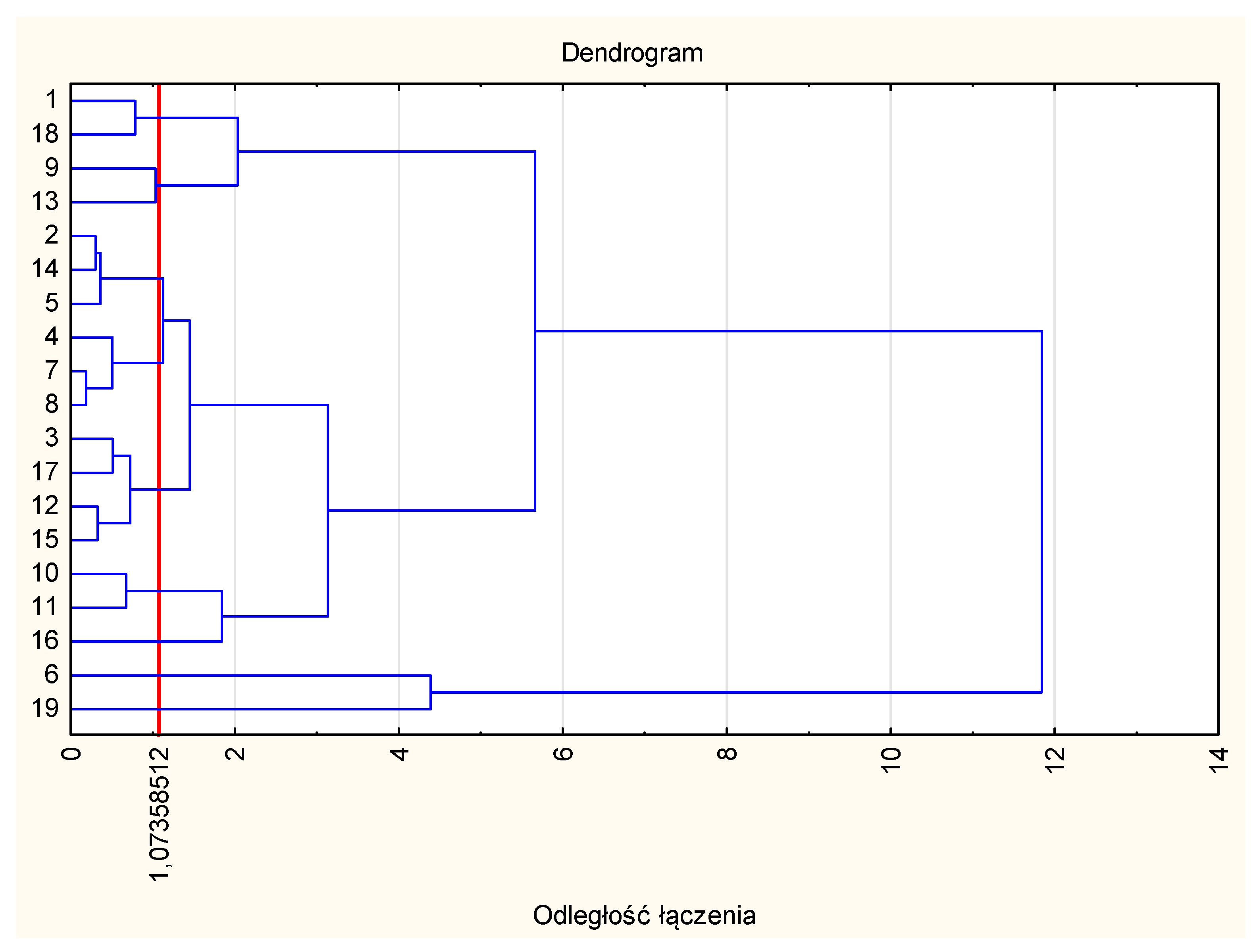
3.2. Groups of Counties Similar with Regard to Size of Agricultural Land Converted to Non-Agricultural Use
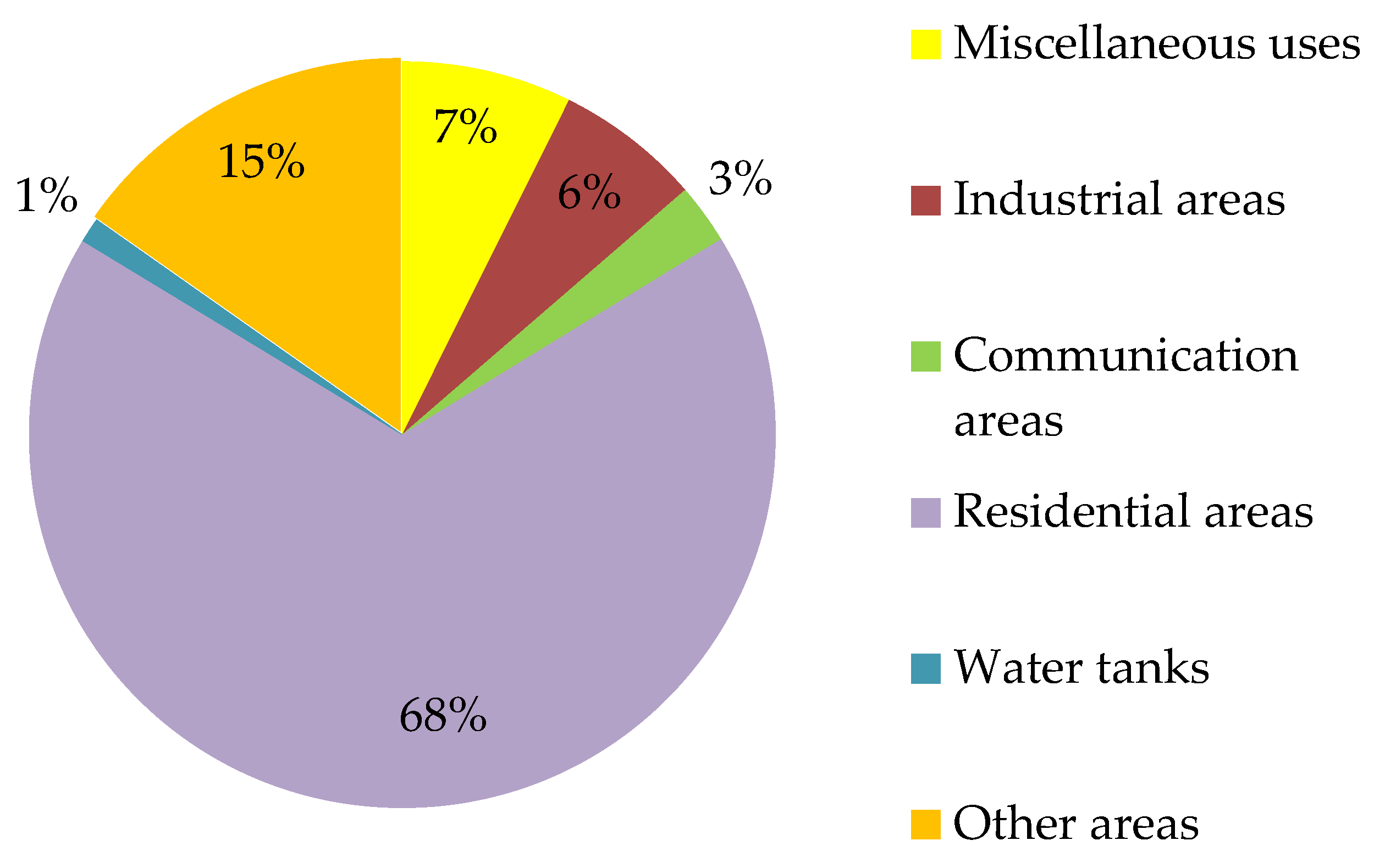
3.3. Specifying the Use of Land Converted to Non-Agricultural Purposes in the Study Period
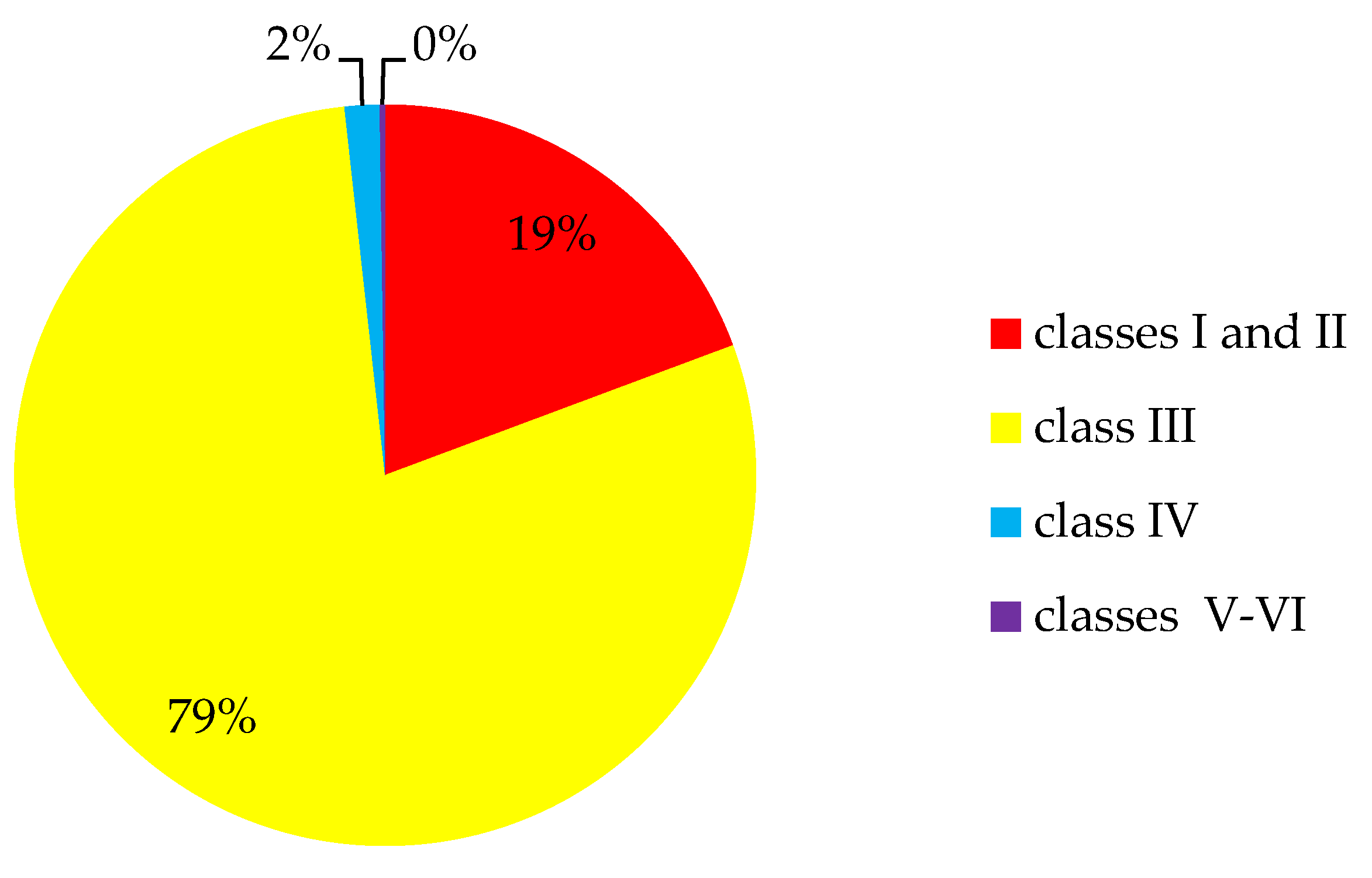
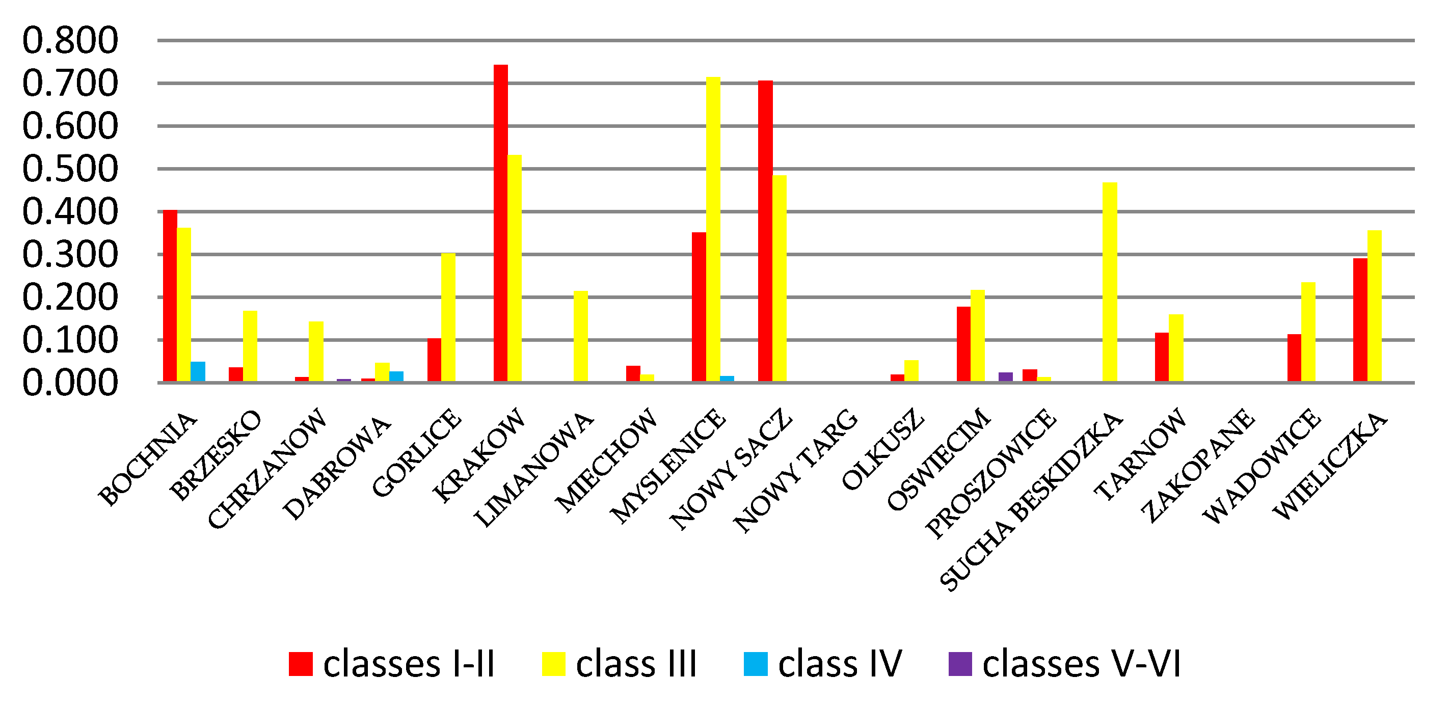
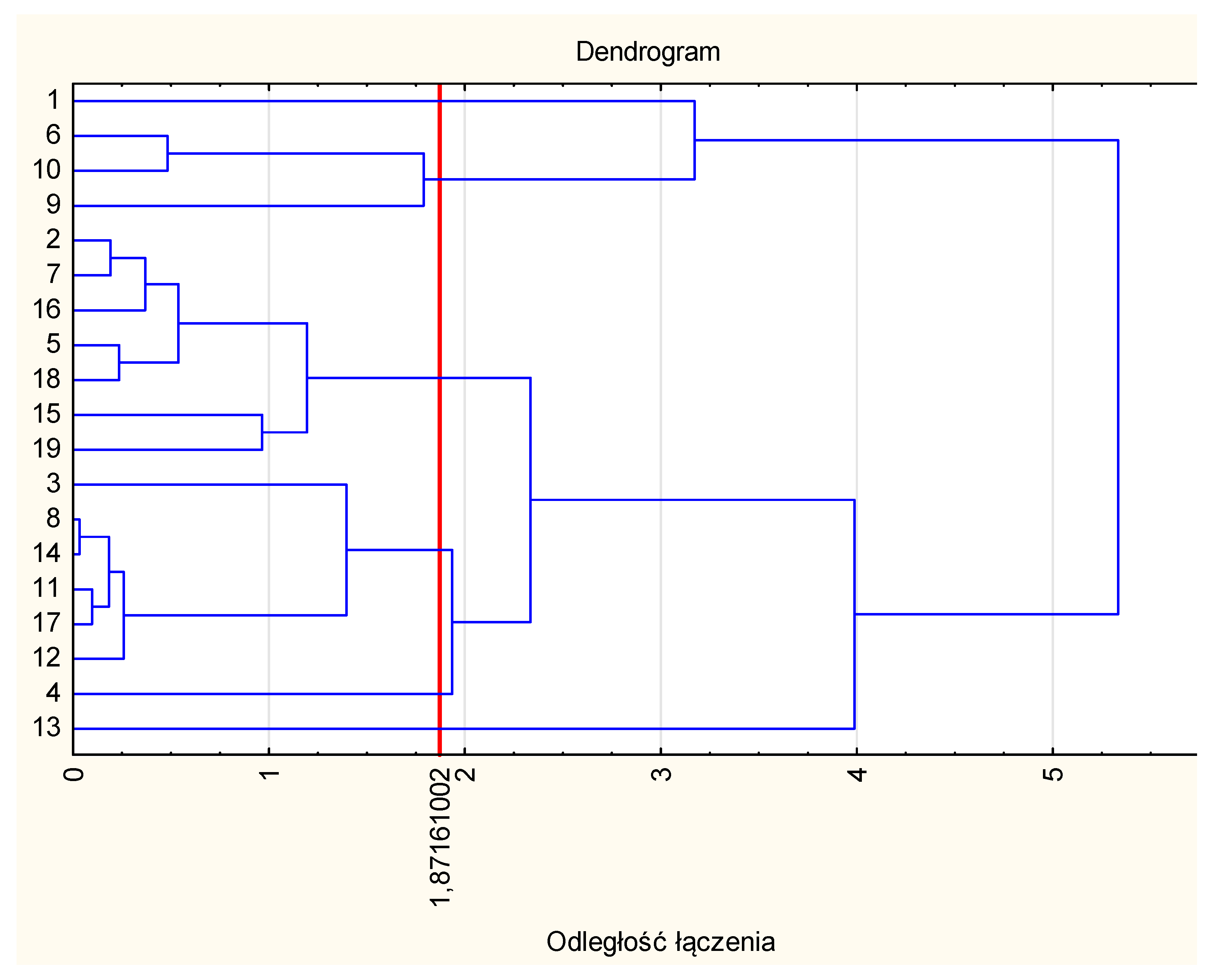
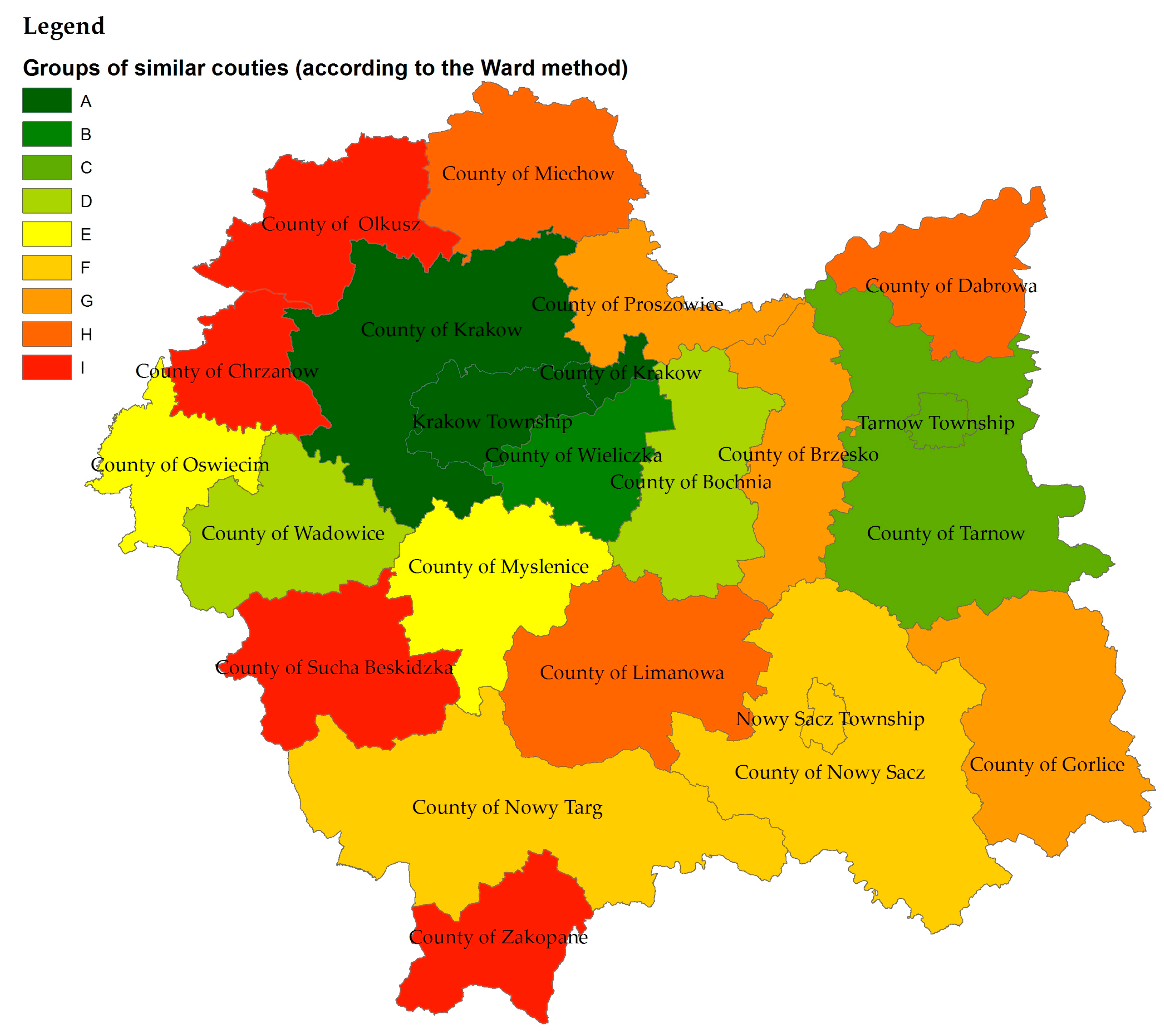
3.4. Groups of Counties Similar in Terms of the Quality of Agricultural Land Converted to Non-Agricultural Use and Earmarked for Residential Purposes
4. Discussion
5. Conclusions
Acknowledgments
Author Contributions
Conflicts of Interest
Appendix A

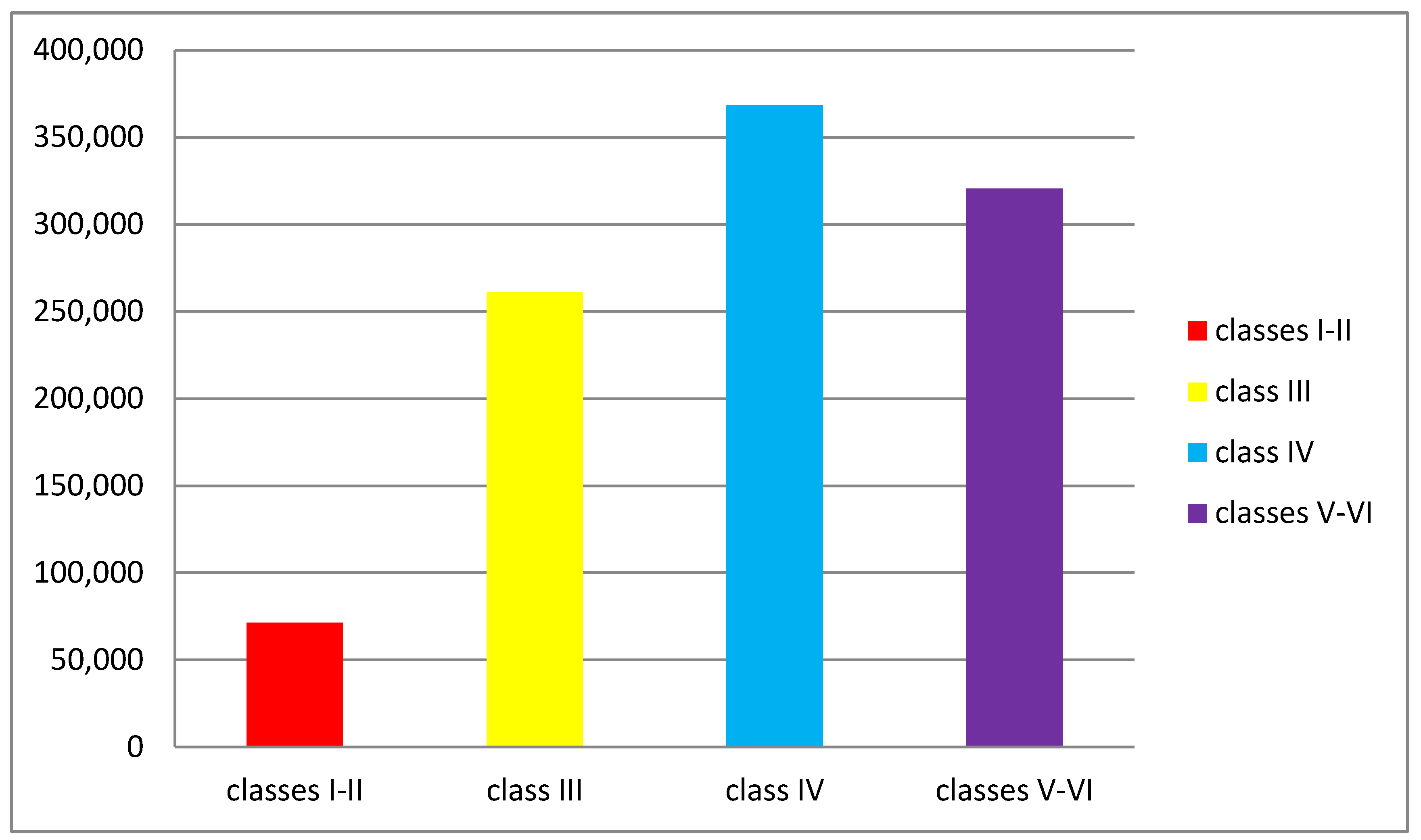
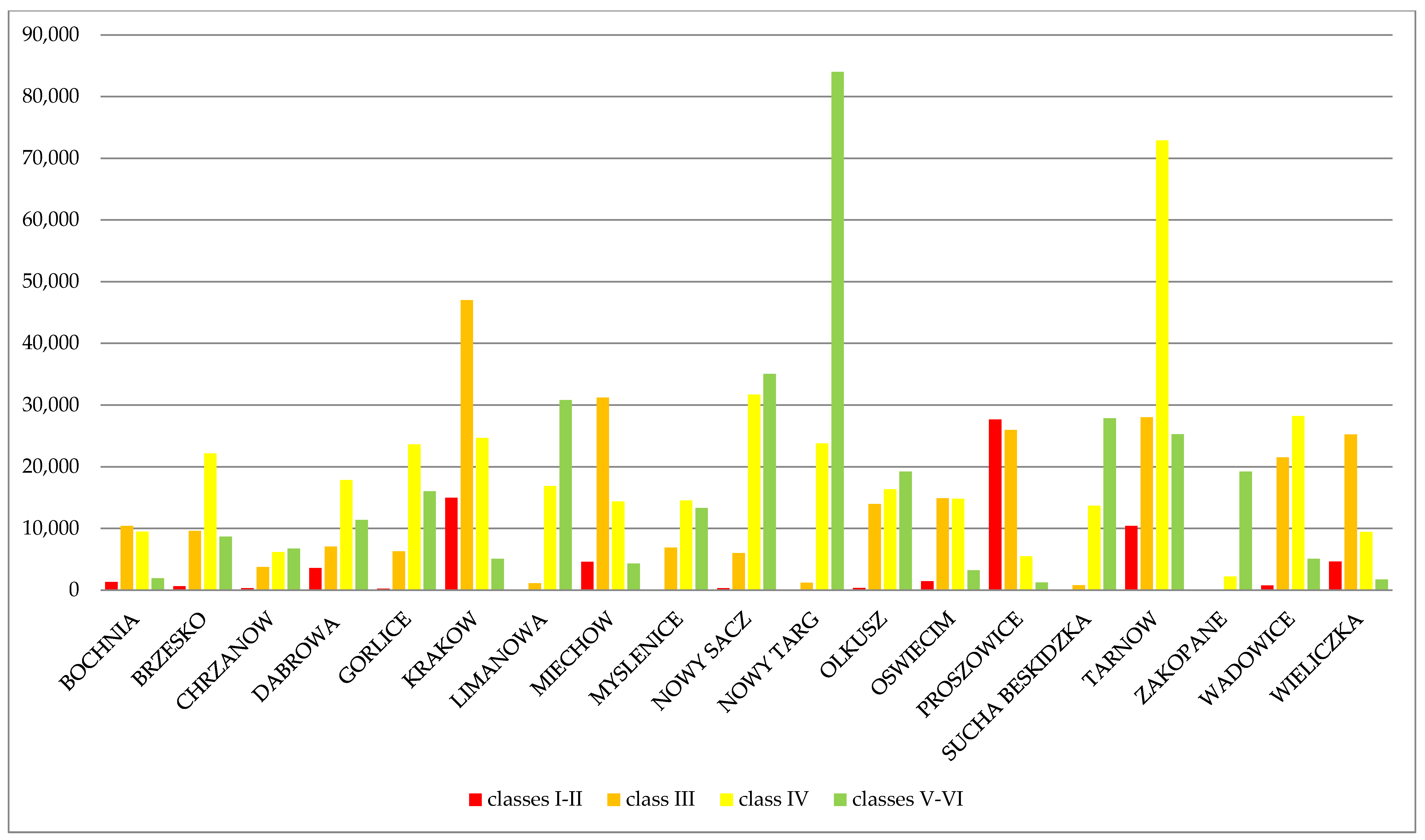
| County No. | County of | Classes I and II (ha) | Class III (ha) | Class IV (ha) | Classes V–VI (ha) |
|---|---|---|---|---|---|
| 1 | BOCHNIA | 1313 | 10,421 | 9481 | 1950 |
| 2 | BRZESKO | 652 | 9611 | 22,178 | 8685 |
| 3 | CHRZANOW | 299 | 3739 | 6161 | 6737 |
| 4 | DABROWA | 3591 | 7049 | 17,842 | 11,407 |
| 5 | GORLICE | 233 | 6309 | 23,625 | 16,040 |
| 6 | KRAKOW | 14,987 | 46,977 | 24,681 | 5073 |
| 7 | LIMANOWA | 0 | 1113 | 16,897 | 30,839 |
| 8 | MIECHOW | 4621 | 31,231 | 14,388 | 4323 |
| 9 | MYSLENICE | 37 | 6908 | 14,552 | 13,319 |
| 10 | NOWY SACZ | 309 | 6019 | 31,729 | 35,083 |
| 11 | NOWY TARG | 7 | 1207 | 23,788 | 84,002 |
| 12 | OLKUSZ | 370 | 13,980 | 16,353 | 19,249 |
| 13 | OSWIECIM | 1467 | 14,887 | 14,828 | 3235 |
| 14 | PROSZOWICE | 27,656 | 25,985 | 5499 | 1250 |
| 15 | SUCHA BESKIDZKA | 10 | 793 | 13,690 | 27,870 |
| 16 | TARNOW | 10,405 | 28,034 | 72,887 | 25,310 |
| 17 | ZAKOPANE | 0 | 16 | 2229 | 19,238 |
| 18 | WADOWICE | 782 | 21,550 | 28,254 | 5090 |
| 19 | WIELICZKA | 4639 | 25,269 | 9464 | 1717 |
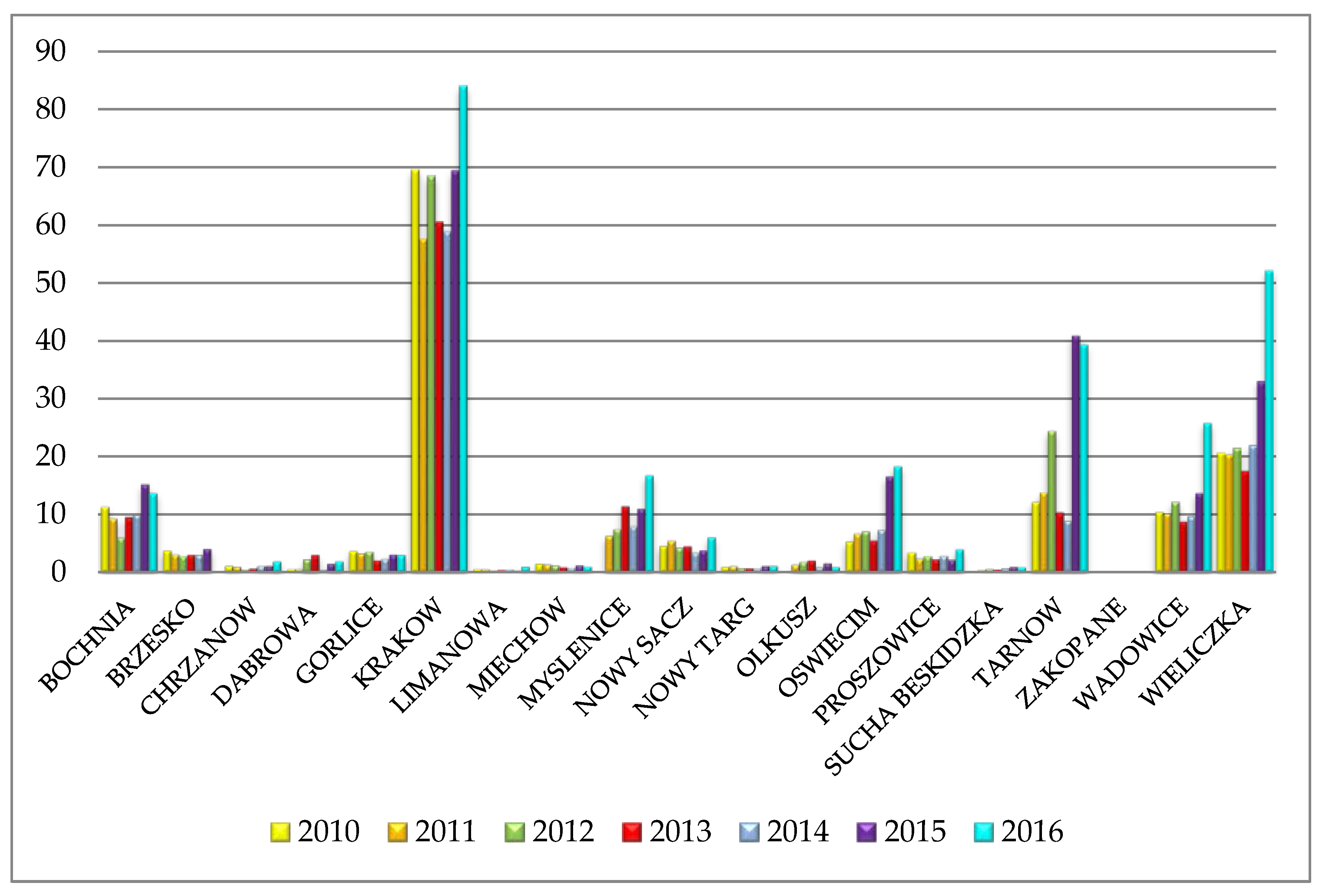
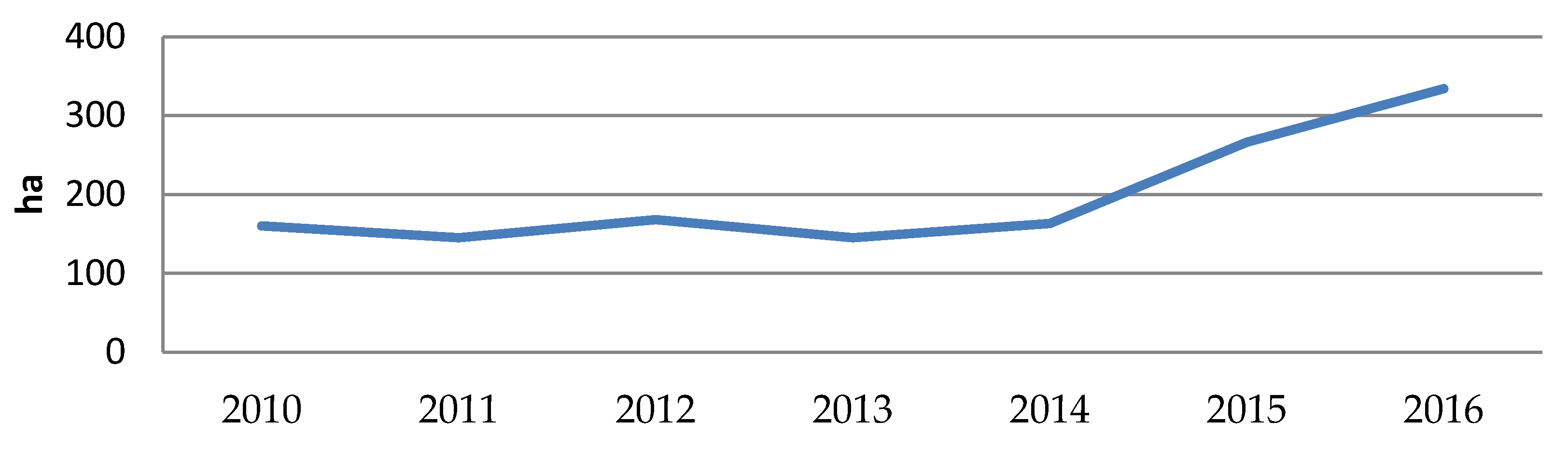
| County No. | County of | 2010 (ha) | 2011 (ha) | 2012 (ha) | 2013 (ha) | 2014 (ha) | 2015 (ha) | 2016 (ha) |
|---|---|---|---|---|---|---|---|---|
| 1 | BOCHNIA | 11.36 | 9.33 | 5.94 | 9.66 | 9.98 | 15.34 | 13.73 |
| 2 | BRZESKO | 3.75 | 3.07 | 2.78 | 3.01 | 3.03 | 4.08 | 7.91 |
| 3 | CHRZANOW | 1.09 | 0.93 | 0.43 | 0.64 | 1.06 | 1.1 | 1.87 |
| 4 | DABROWA | 0.51 | 0.51 | 2.25 | 3.01 | 0.41 | 1.5 | 1.88 |
| 5 | GORLICE | 3.68 | 3.27 | 3.57 | 2.07 | 2.314 | 3.1 | 3.03 |
| 6 | KRAKOW | 69.63 | 57.69 | 68.54 | 60.61 | 58.92 | 69.47 | 84.11 |
| 7 | LIMANOWA | 0.52 | 0.5 | 0.25 | 0.38 | 0.47 | 0.24 | 0.96 |
| 8 | MIECHOW | 1.49 | 1.35 | 1.18 | 0.88 | 0.74 | 1.18 | 0.99 |
| 9 | MYSLENICE | 8.97 | 6.31 | 7.44 | 11.52 | 7.98 | 11.11 | 16.83 |
| 10 | NOWY SACZ | 4.58 | 5.48 | 4.26 | 4.53 | 3.38 | 3.84 | 6.09 |
| 11 | NOWY TARG | 0.93 | 1.07 | 0.71 | 0.67 | 0.6006 | 1.09 | 1.09 |
| 12 | OLKUSZ | 1.12 | 1.31 | 1.79 | 2.05 | 0.84 | 1.56 | 0.91 |
| 13 | OSWIECIM | 5.33 | 6.69 | 7.08 | 5.53 | 7.32 | 16.68 | 18.42 |
| 14 | PROSZOWICE | 3.45 | 2.33 | 2.81 | 2.29 | 2.82 | 2.19 | 4 |
| 15 | SUCHA BESKIDZKA | 0.58 | 0.36 | 0.54 | 0.46 | 0.71 | 0.93 | 0.87 |
| 16 | TARNOW | 12.17 | 13.83 | 24.43 | 10.45 | 8.92 | 40.96 | 39.51 |
| 17 | ZAKOPANE | 0 | 0.15 | 0 | 0 | 0 | 0 | 0 |
| 18 | WADOWICE | 10.46 | 10.21 | 12.2 | 8.8 | 9.71 | 13.79 | 25.94 |
| 19 | WIELICZKA | 20.76 | 20.39 | 21.51 | 17.66 | 22.08 | 33.24 | 52.21 |
| County No. | County of | Classes I and II | Class III | Class IV | Classes V–VI |
|---|---|---|---|---|---|
| 1 | BOCHNIA | 0.404 | 0.362 | 0.048 | 0.000 |
| 2 | BRZESKO | 0.035 | 0.168 | 0.000 | 0.000 |
| 3 | CHRZANOW | 0.013 | 0.142 | 0.002 | 0.008 |
| 4 | DABROWA | 0.009 | 0.046 | 0.026 | 0.000 |
| 5 | GORLICE | 0.103 | 0.302 | 0.000 | 0.000 |
| 6 | KRAKOW | 0.742 | 0.532 | 0.003 | 0.003 |
| 7 | LIMANOWA | 0.000 | 0.214 | 0.000 | 0.000 |
| 8 | MIECHOW | 0.040 | 0.019 | 0.000 | 0.000 |
| 9 | MYSLENICE | 0.351 | 0.715 | 0.015 | 0.000 |
| 10 | NOWY SACZ | 0.706 | 0.485 | 0.000 | 0.000 |
| 11 | NOWY TARG | 0.000 | 0.000 | 0.000 | 0.000 |
| 12 | OLKUSZ | 0.019 | 0.052 | 0.000 | 0.001 |
| 13 | OSWIECIM | 0.178 | 0.217 | 0.001 | 0.024 |
| 14 | PROSZOWICE | 0.030 | 0.014 | 0.000 | 0.000 |
| 15 | SUCHA BESKIDZKA | 0.000 | 0.468 | 0.000 | 0.000 |
| 16 | TARNOW | 0.117 | 0.160 | 0.000 | 0.000 |
| 17 | ZAKOPANE | 0.000 | 0.000 | 0.000 | 0.001 |
| 18 | WADOWICE | 0.113 | 0.234 | 0.000 | 0.000 |
| 19 | WIELICZKA | 0.291 | 0.355 | 0.000 | 0.000 |
Appendix B

Appendix C
Appendix D
References
- Act on Environmental Protection of 27 April 2001. Available online: http://prawo.sejm.gov.pl/isap.nsf/DocDetails.xsp?id=WDU20010620627 (accessed on 25 September 2017).
- Report of the World Commission on Environment and Development: Our Common Future. Published in 1987. Available online: http://www.un-documents.net/our-common-future.pdf (accessed on 25 September 2017).
- Dizdaroglu, D. The Role of Indicator-Based Sustainability Assessment in Policy and the Decision-Making. Process: A Review and Outlook. Sustainability 2017, 9, 1018. [Google Scholar] [CrossRef]
- Sansoni, M.; Bonazzi, E.; Goralczyk, M.; Stauvermann, P.J. RAMEA: How to support regional policies towards sustainable development. Sustain. Dev. 2010, 18, 202–210. [Google Scholar] [CrossRef]
- Dawidowcz, A.; Zrobek, R. Land Administration System for Sustainable Development—Case Study of Poland. Real Estate Manag. Valuat. 2017, 25, 112–122. [Google Scholar] [CrossRef]
- Williamson, I.P.; Enemark, S.; Wallace, J.; Rajabifard, A. Land Administration for Sustainable Development; ESRI Press: Redlands, CA, USA, 2010; p. 487. ISBN 978-1-58948-041-4. [Google Scholar]
- Williamson, I.; Bennett, R.; Rajabifard, A.; Wallace, J. Lessons for Federal Countries That Have State Land Registries—The Australian Experience. In Proceedings of the 11th South East Asian Surveyors Conference (SEASC), Kuala Lumpur, Malaysia, 22–24 June 2011. [Google Scholar]
- Shen, B.; Lepech, M.D. Probabilistic Design of Environmentally Sustainable Reinforced-Concrete Transportation Infrastructure Incorporating Maintenance Optimization. J. Infrastruct. Syst. 2017, 23. [Google Scholar] [CrossRef]
- Diogo, V.; Koomen, E.; Kuhlman, T. An economic theory-based explanatory model of agricultural land-use patterns: The Netherlands as a case study. Agric. Syst. 2015, 139, 1–16. [Google Scholar] [CrossRef]
- Head, K.; Ries, J.; Swenson, D. Agglomeration Benefits and Location Choice—Evidence from Japanese Manufacturing Investments in the UNITED-STATES. J. Int. Econ. 1995, 38, 223–247. [Google Scholar] [CrossRef]
- Špulerová, J.; Dobrovodská, M.; Izakovičová, Z.; Kenderessy, P.; Petrovič, F.; Štefunková, D. Developing a strategy for the protection of traditional agricultural landscapes based on a complex landscape-ecological evaluation (the case of a mountain landscape in Slovakia). Morav. Geogr. Rep. 2013, 21, 15–26. [Google Scholar] [CrossRef]
- Jiang, G.; Ma, W.; Qu, Y.; Zhang, R.; Zhou, D. How does sprawl differ across urban built-up land types in China? A spatial-temporal analysis of the Beijing metropolitan area using granted land parcel data. Cities 2016, 58, 1–9. [Google Scholar] [CrossRef]
- Jiang, G.; Ma, W.; Wang, D.; Dingyang, Z.; Ruijuan, Z.; Tao, Z. Identifying the internal structure evolution of urban built-up land sprawl (UBLS) from a composite structure perspective: A case study of the Beijing metropolitan area, China. Land Use Policy 2017, 62, 258–267. [Google Scholar] [CrossRef]
- Jiang, G.; He, X.; Qu, Y.; Ruijuan, Z.; Yuan, M. Functional evolution of rural housing land: A comparative analysis across four typical areas representing different stages of industrialization in China. Land Use Policy 2016, 57, 645–654. [Google Scholar] [CrossRef]
- Kanianska, R.; Kizekova, M.; Novacek, J.; Zeman, M. Land-use and land-cover changes in rural areas during different political systems: A case study of Slovakia from 1782 to 2006. Land Use Policy 2014, 36, 554–566. [Google Scholar] [CrossRef]
- Nowak, A.; Schneider, C. Environmental characteristics, agricultural land use, and vulnerability to degradation in Malopolska Province (Poland). Sci. Total Environ. 2017, 590–591, 620–632. [Google Scholar] [CrossRef] [PubMed]
- Bucała-Hrabia, A. From communism to a free-market economy: A reflection of socio-economic changes in land use structure in the Vicinity of the city (beskid sądecki, western Polish carpathians). Geogr. Polonica 2017, 90, 65–79. [Google Scholar] [CrossRef]
- Mazzocchi, C.; Corsi, S.; Sali, G. Agricultural Land Consumption in Periurban Areas: A Methodological Approach for Risk Assessment Using Artificial Neural Networks and Spatial Correlation in Northern Italy. Appl. Spat. Anal. Policy 2017, 10, 3–20. [Google Scholar] [CrossRef]
- Ceccarelli, T.; Bajocco, S.; Perini, L.L.; Salvati, L. Urbanisation and land take of high quality agricultural soils—Exploring long-term land use changes and land capability in Northern Italy. Int. J. Environ. Res. 2014, 8, 181–192. [Google Scholar]
- Van Vliet, J.; de Groot, H.L.F.; Rietveld, P.; Verburg, P.H. Manifestations and underlying drivers of agricultural land use change in Europe. Landsc. Urban Plan. 2015, 133, 24–36. [Google Scholar] [CrossRef]
- Act on the Protection of Agricultural and Forest Land of 3 February 1995. Available online: http://prawo.sejm.gov.pl/isap.nsf/DocDetails.xsp?id=WDU19950160078 (accessed on 25 September 2017).
- Busko, M.; Kolinska, M. Issues related to exclusion of arable lands, located within borders of urban areas, from the agricultural production after updating of legal regulations. Przeglad Geodezyjny 2015, 3, 7–13. [Google Scholar] [CrossRef]
- Bielska, A.; Turek, A. Analysis of the needs for updates of the land and building register considering the procedure of exclusion of agricultural land from production. Infrastruct. Ecol. Rural Areas 2016, 1633–1644. [Google Scholar] [CrossRef]
- Salata, T.; Prus, B.; Janus, J. Planning as trigger for land use changes. Eng. Rural Dev. 2015, 14, 729–734. [Google Scholar]
- Fang, Y.; Cote, R.P.; Qin, R. Industrial sustainability in China: Practice and prospects for eco-industrial development. J. Environ. Manag. 2007, 83, 315–328. [Google Scholar] [CrossRef] [PubMed]
- Funderburg, R.G.; Zhou, X. Trading industry clusters amid the legacy of industrial land-use planning in southern California. Environ. Plan. A 2013, 45, 2752–2770. [Google Scholar] [CrossRef]
- Gebeyehu, A.T. Urban land use dynamics, the nexus between land use pattern and its challenges: The case of Hawassa city, Southern Ethiopia. Land Use Policy 2015, 45, 159–175. [Google Scholar] [CrossRef]
- Lai, Y.; Peng, Y.; Li, B.; Lin, Y. Industrial land development in urban villages in China: A property rights perspective. Habitat Int. 2014, 41, 185–194. [Google Scholar] [CrossRef]
- Li, D.; Zhang, C.; Pizzol, L.; Critto, A.; Zhang, H.; Lv, S.; Marcomini, A. Regional risk assessment approaches to land planning for industrial polluted areas in China: The Hulunbeier region case study. Environ. Int. 2014, 65, 16–32. [Google Scholar] [CrossRef] [PubMed]
- Li, J.; Zhang, W.; Chen, H.; Yu, J. The spatial distribution of industries in transitional China: A study of Beijing. Habitat Int. 2015, 49, 33–44. [Google Scholar] [CrossRef]
- Kaliszewski, A.; Mlynarski, W.; Golos, P. Factors limiting afforestation of post-agricultural lands in Poland according to the survey results. Sylwan 2016, 160, 846–854. [Google Scholar]
- Bieda, A.; Jasinska, E.; Preweda, E. Surveying Protection of Agricultural Land in Poland. In Proceedings of the 9th International Conference on Environmental Engineering (ICEE), Vilnius, Lithuania, 22–23 May 2014. [Google Scholar] [CrossRef]
- Marks-Bielska, R.; Zukovskis, J. Conditions of Changes in the Agricultural Land Market in Poland during the Years 1992–2009: Background for Systematic Research. In Proceedings of the 5th International Scientific Conference on Rural Development, Aleksandras Stulginskis University, Akademija, Lithuania, 24–25 November 2011. [Google Scholar]
- Just, D.R.; Kropp, J.D. Production incentives from static decoupling: Land use exclusion restrictions. Am. J. Agric. Econ. 2013, 95, 1049–1067. [Google Scholar] [CrossRef]
- Tarasovičová, Z.; Saksa, M.; Blažík, T.; Falťan, V. Changes in agricultural land use in the context of ongoing transformational processes in Slovakia. Agriculture 2013, 59, 49–64. [Google Scholar] [CrossRef]
- Labarthe, P.; Laurent, C. Service economics and public policies for agricultural extension. Cah. Agric. 2011, 20, 343–351. [Google Scholar]
- Balawejder, M.; Wójciak, E. Application of gis tools in analysing a road network providing access to cadastral parcels in the project concerning land consolidation and exchange. In Proceedings of the Geographic Information Systems Conference and Exhibition “GIS ODYSSEY 2017”, Trento, Vattaro, Italy, 4–8 September 2017. [Google Scholar]
- Du, P.; Wood, A.; Ditchman, N.; Stephens, B. Life Satisfaction of Downtown High-Rise vs. Suburban Low-Rise Living: A Chicago Case Study. Sustainability 2017, 9, 1052. [Google Scholar] [CrossRef]
- Ruan, X.; Qiu, F.; Dyck, M. The effects of environmental and socioeconomic factors on land-use changes: A study of Alberta, Canada. Environ. Monit. Assess. 2016, 188, 446. [Google Scholar] [CrossRef] [PubMed]
- Kim, J.J.; Goodwin, C.W.; Kim, S. Communication turns green construction planning into reality. J. Green Build. 2017, 12, 168–186. [Google Scholar] [CrossRef]
- Fritz-Vietta, N.V.M.; Tahirindraza, H.S.; Stoll-Kleemann, S. Local people’s knowledge with regard to land use activities in southwest Madagascar—Conceptual insights for sustainable land management. J. Environ. Manag. 2017, 199, 126–138. [Google Scholar] [CrossRef] [PubMed]
- Murgida, A.M.; Gonzalez, M.; Tiessen, H. Rainfall trends, land use change and adaptation in the Chaco salteo region of Argentina. Reg. Environ. Chang. 2014, 14, 1387–1394. [Google Scholar] [CrossRef]
- Jiang, G.; Ma, W.; Zhou, D.; Zhao, Q.; Zhang, R. Agglomeration or dispersion? Industrial land-use pattern and its impacts in rural areas from China’s township and village enterprises perspective. J. Clean. Prod. 2017, 159, 207–219. [Google Scholar] [CrossRef]
- Li, Y.; Hu, Z. Approaching Integrated Urban-Rural Development in China: The Changing Institutional Roles. Sustainability 2015, 7, 7031–7048. [Google Scholar] [CrossRef]
- Bishai, M.F. The Development of Industrial Land in Taiwan—A Legal Framework for State Control. J. Dev. Areas 1991, 26, 53–64. [Google Scholar]
- Byrd, W.A.; Li, Q. China’s Rural Industry: Structure, Development, and Reform; A World Bank Research Publication; Oxford University Press: New York, NY, USA, 1990; ISBN 0-19-520822-6. [Google Scholar]
- Choy, L.H.T.; Lai, Y.; Lok, W. Economic performance of industrial development on collective land in the urbanization process in China: Empirical evidence from Shenzhen. Habitat Int. 2013, 40, 184–193. [Google Scholar] [CrossRef]
- Hakizimana, C.; Goldsmith, P.; Nunow, A.A.; Roba, A.W.; Biashara, J.K. Land and agricultural commercialisation in Meru County, Kenya: Evidence from three models. J. Peasant Stud. 2017, 44, 555–573. [Google Scholar] [CrossRef]
- Siejka, M. Public Purpose Investments Site Selection in Real Estate Management—Case Study in Poland. In Proceedings of the 16th International Multidisciplinary Scientific Geo Conference SGEM, Albena, Bulgaria, 28 June–6 July 2016; pp. 503–509. [Google Scholar]
- Lausch, A.; Blaschke, T.; Haase, D.; Herzog, F.; Syrbe, R.U.; Tischendorf, L.; Walz, U. Understanding and quantifying landscape structure—A review on relevant process characteristics, data models and landscape metrics. Ecol. Model. 2015, 295, 31–41. [Google Scholar] [CrossRef]
- Regulation of the Minister of Regional Development and Construction of 15 July 2016 on the Register of Land and Buildings. Available online: http://prawo.sejm.gov.pl/isap.nsf/DocDetails.xsp?id=WDU20160001034 (accessed on 25 September 2017).
- Statistical Office in Cracow. Agriculture in Malopolskie Voivodship in 2015 Information and Statistics; Statistical Office in Cracow: Krakow, Poland, 2016.
- Litwin, U.; Szafranska, B. Using GIS in Management and Agricultural Surveying in the Malopolska Province; Agricultural University: Krakow, Poland, 2017. [Google Scholar]
- Baczwarow, M.; Suliborski, A. The Compendium of Knowledge about Political Geography and Geopolitics; Terminology; Polish Scientific Publishers: Warsaw, Poland, 2002. [Google Scholar]
- Czekanowski, J. The Outline of Statistical Methods In application to Anthropology; Works of the Warsaw Scientific Society: Warsaw, Poland, 1913. [Google Scholar]
- Kukula, K. Statistical Methods for Analysis of Economic Structures; Educational Publishing House: Krakow, Poland, 1996. [Google Scholar]
- Mlodak, A. Taxonomic Analysis in Regional Statistics; Difin: Warsaw, Poland, 2006. [Google Scholar]
- Gatnar, E. Symbolic Methods of Data Classification; Polish Scientific Publishers: Warsaw, Poland, 1998. [Google Scholar]
- Stanisz, A. Intelligible Statistics Course Using STATISTICA PL on Medical Examples; StatSoft Poland: Krakow, Poland, 2007. [Google Scholar]
- Wezyk, P.; Wojtowicz-Nowakowska, A.; Pierzchalski, M.; Mlost, J.; Szafranska, B. Map of land cover changes in Malopolska in 1986–2011 based on object classification of satellite images LANDSAT and RapidEye. Photogramm. Cartogr. Remote Sens. Arch. 2013, 25, 273–284. [Google Scholar]
- Lowicki, D. Land use changes in Poland during transformation. Case study of Wielkopolska region. Landsc. Urban Plan. 2008, 87, 279–288. [Google Scholar] [CrossRef]
- Kocur-Bera, K. Farmer’s perception of agricultural land after accesion to the EU—A case study. In Proceedings of the 2016 International Conference, Economic Scince for Rural Development, Llu Esaf, Jelgava, Latvia, December 2016–April 2017. [Google Scholar]
- Kocur-Bera, K. Determinants of Agricultural Land Price in Poland—A Case Study Covering A Part of the EuroRegion Baltic. Cah. Agric. 2016, 25, 25004. [Google Scholar] [CrossRef]
- Busko, M.; Meusz, A. Current status of real estate cadastre in Poland with reference to historical conditions of different regions of the country. In Proceedings of the 9th International Conference Environmental Engineering, Vilnius, Lithuania, 22–23 May 2014. [Google Scholar]
- Bielecka, E.; Calka, B. The Analysis of the Land Exclusions from Agricultural and Forest Production in the Rural Areas. Available online: http://yadda.icm.edu.pl/yadda/element/bwmeta1.element.agro-48516e32-1887-4944-bdf6-d6962f0e5a40 (accessed on 25 September 2017).
- Bielska, A.; Turek, A.; Maciejewska, A.; Bozym, K. Problems of agricultural land protection in suburbanization process. Infrastruct. Ecol. Rural Areas 2015, 1035–1045. [Google Scholar] [CrossRef]
- Václavík, T.; Rogan, J. Identifying Trends in Land Use/Land Cover Changes in the Context of Post-Socialist Transformation in Central Europe: A Case Study of the Greater Olomouc Region, Czech Republic. GISci. Remote Sens. 2006, 46, 54–76. [Google Scholar] [CrossRef]
- Ustaoglu, E.; Williams, B. Determinants of Urban Expansion and Agricultural Land Conversion in 25 EU Countries. Environ. Manag. 2017, 60, 717–746. [Google Scholar] [CrossRef] [PubMed]


© 2018 by the authors. Licensee MDPI, Basel, Switzerland. This article is an open access article distributed under the terms and conditions of the Creative Commons Attribution (CC BY) license (http://creativecommons.org/licenses/by/4.0/).
Share and Cite
Busko, M.; Szafranska, B. Analysis of Changes in Land Use Patterns Pursuant to the Conversion of Agricultural Land to Non-Agricultural Use in the Context of the Sustainable Development of the Malopolska Region. Sustainability 2018, 10, 136. https://doi.org/10.3390/su10010136
Busko M, Szafranska B. Analysis of Changes in Land Use Patterns Pursuant to the Conversion of Agricultural Land to Non-Agricultural Use in the Context of the Sustainable Development of the Malopolska Region. Sustainability. 2018; 10(1):136. https://doi.org/10.3390/su10010136
Chicago/Turabian StyleBusko, Malgorzata, and Beata Szafranska. 2018. "Analysis of Changes in Land Use Patterns Pursuant to the Conversion of Agricultural Land to Non-Agricultural Use in the Context of the Sustainable Development of the Malopolska Region" Sustainability 10, no. 1: 136. https://doi.org/10.3390/su10010136
APA StyleBusko, M., & Szafranska, B. (2018). Analysis of Changes in Land Use Patterns Pursuant to the Conversion of Agricultural Land to Non-Agricultural Use in the Context of the Sustainable Development of the Malopolska Region. Sustainability, 10(1), 136. https://doi.org/10.3390/su10010136