Article

Extension Activity Support System (EASY): A Web-Based Prototype for Facilitating Farm Management

1
Cooperative Research Centre for Spatial Information, Ground floor, 204 Lygon Street, 5th floor, Carlton, VIC 3053, Australia
2
Spatial Vision, Level 2, 170 Queen Street Melbourne, VIC 3000, Australia
3
Australian Urban Research Infrastructure Network, Faculty of Architecture, Planning and Building, The University of Melbourne, Level 5, Architecture Building, Victoria 3010, Australia
4
Department of Primary Industries Victoria, Rutherglen Centre, RMB 1145, Rutherglen, VIC 3685, Australia
*
Author to whom correspondence should be addressed.
Future Internet 2012, 4(1), 42-64; https://doi.org/10.3390/fi4010042
Submission received: 4 November 2011 / Revised: 27 December 2011 / Accepted: 27 December 2011 / Published: 4 January 2012
(This article belongs to the Special Issue Internet and Landscapes)

Abstract

:
In response to disparate advances in delivering spatial information to support agricultural extension activities, the Extension Activity Support System (EASY) project was established to develop a vision statement and conceptual design for such a system based on a national needs assessment. Personnel from across Australia were consulted and a review of existing farm information/management software undertaken to ensure that any system that is eventually produced from the EASY vision will build on the strengths of existing efforts. This paper reports on the collaborative consultative process undertaken to create the EASY vision as well as the conceptual technical design and business models that could support a fully functional spatially enabled online system.

1. Introduction

The ubiquity of low-cost high-speed computing has led to the development of technology-based tools, systems, and solutions across a number of disciplines; we refer to these generically as “decision support systems” (DSSs). Disciplines such as agriculture that have an inherent spatial component have seen additional DSS development effort to accommodate different spatial scales that are inherent in various facets of agricultural management. However, the lack of uptake of agricultural DSSs by farmers has been noted and studied with a view to overcoming this reluctance. (e.g., [1,2]).
The need for, development of, and (lack of) use of DSSs in agriculture is not limited to farm managers. Agriculture is a major driver of economics, social welfare, and environmental quality in many regions. Consequently, many DSSs have been designed for use in the development and implementation of agricultural policy. However, limited uptake of DSSs for agricultural policy has also been noted and attempts have been made to enhance DSSs for policy concerns [3].
It has been suggested [4] that the reason for the lack of uptake of DSSs across agricultural sectors has been due to many DSSs being focused on a single aspect of agriculture instead of employing an integrated approach to addressing social, economic, and environmental issues of concern to farmers and policy-makers alike. This has been noticed by the agricultural DSS research community which has responded by re-orienting itself; Bezlepkina et al. [5] documented a sharp increase since the 1990s in the scientific literature of research publications that address the integration of multiple concerns in agricultural DSSs. And indeed, operational agricultural systems based on integration of multiple elements and concerns have been developed; one example is SEAMLESS [6] that is a major European initiative.
At the farm level, many DSSs developed by scientists have focused on various aspects of designing better farm systems. The Farming Systems Design Symposium held in 2007 in Catania, Italy that led to a special issue of the European Journal of Agronomy [7] provides numerous specific examples. Other examples abound on various aspects of farm management such as crop and pasture rotation (e.g., [8,9]). The commercial sector has also developed farm management DSSs with farm economics being their focus; some of these are discussed subsequently in relation to Table 1.
An interesting recent approach to, and use of, DSSs has been to create a platform for collaboration. Lacy [24] described a participatory model for farmers in New South Wales (Australia) named “Cropcheck” that was developed to collect valuable semi-subjective information from farmers that could be used in designing improved farm systems. Vaysières et al. [25] also employed a participatory approach to develop a farm model (“GAMEDE”) whose focus was policy support rather than management of individual farms.
The significant efforts expended to develop science-based DSSs for agriculture have recently been accompanied by efforts to increase their uptake. The goal of such work has been to make connections among disparate parts of the agricultural community. Le Gal et al. [26] reviewed general approaches to designing new farm systems and described a methodological framework to integrate biotechnical knowledge, operational farm management experience, and agricultural advisory services to achieve the goal of designing better agricultural systems. The framework described was based on frameworks for organizing interactions among researchers and end-users that had been described in [27].
Table 1. Assessment of functionality of existing systems complementary to the EASY vision.
Futureinternet 04 00042 i001
1 CAMS—Catchment Activity Management System. A state of Victoria government application used by Catchment Management Authorities (CMAs) to manage incentive-funded on-ground works projects [10].2 EBMP—Environmental Management Best Practices. A state of Victoria government approved environmental farm planning program that encourages all landholders to adopt best management practices [11].3 eFarmer—A Victorian-based web delivered prototype that provides information and spatial functionality directly to farmers for the creation of farm plans [12]. Available online: http://efarmer.spatialvision.com.au/efarmer/login.jsf?windowId=479 (accessed on April 2011).4 ArcView/ArcGIS™—Environmental Systems Research Institute. A commercially available desktop geographic information system [13].5 ifarm™—A commercial farm management application [14].6 Back Paddock—A commercial farm management application [15].7 SLIP Portal—Shared Land Information Platform. A Western Australia-based platform for providing public and private access to cross-Government data bases including those related to farm and land management [16].8 VicMap. A Victoria-based platform for providing public and private access to cross-Government databases including those related to farm and land management [17].9 GoogleMaps™/Google Earth™. Web-based freeware providing digital imagery worldwide [18,19].10 SIEVE—Spatial Information Exploration and Visualisation Environment. A prototypical research application based on computer-gaming engines for visualisation of farm management information [20].11 NDG—National Data Grid. A demonstrator research project to for the rapid access of spatial data for landscape modelling [21].12 VRO—Victorian Resources Online. A Victoria-based platform for providing natural resource information including maps [22].13 AANRO—Australian Agriculture and Natural Resources Online. An Australia-wide web-based integrated knowledge discovery tool for agriculture and natural resources [23].
However, many agricultural DSSs still largely target a single end-user group—e.g., commercial farmers or policy-makers—or focus on a single theme such as improved nutrient management on farms. The work described herein is focused on overcoming this limitation. It builds non-explicitly on the work of Hochman et al. [28] who consulted with a variety of experts to identify issues that are important in the design of agricultural DSSs. The EASY project goes one step further in using a consultative approach to design the specifics of an agricultural DSS that provides a mechanism for assembling scientific and operational knowledge in a way that can be used by scientists, policy-makers, and farm managers.
The proponents of EASY have approached the issue of the need for integrated agricultural DSSs from a perspective of system design. This contrasts with approaching agricultural DSSs from the perspective of producers of scientific results, or the needs of policy-makers or operational agricultural experts. Hence, the EASY system is designed as an agriculturally targeted computer-based structure that supports certain basic functionalities and core data types, and that has the flexibility to expand to include a variety of databases and analytical modules. Critically, its design and base functionality provides the capability to support decisions at multiple spatial and temporal scales—functionality that has been identified as being critical for agricultural DSSs [29].
The purpose of this paper is to describe the fundamental elements of an integrative systems-based agricultural DSS. A key element of the EASY design is that it is expandable and flexible to allow for additional uses and users that require specialized databases and models.

2. Overview

The need to deliver spatial information for improved production and environmental management of individual farms within larger regional planning areas is well-recognised [12,30]. The Extension Activity Support System (EASY) project was established to undertake the foundational work necessary to establish a national (Australian) system for achieving this in response to major user needs. The creation of the EASY project in April 2009 was driven by the success and learnings of a previously created tool known as eFarmer. The Victorian State Government, working closely with a number of Catchment Management Authorities (CMAs), and with the geospatial firm Spatial Vision had developed and trialled a web-based application (eFarmer) that supported the capture, viewing and sharing of natural resource management information across farms, landscapes and catchments [12]. eFarmer was designed to support planning for farms and catchments such that farmers could implement activities on their properties that may contribute to the achievement of catchment-wide environmental outcomes. Hence eFarmer had the capability to support the management of individual farms as well as being able to provide information required for developing public policy across larger areas.
The desire to deliver farm and landscape spatial information to support improved management, termed herein “farm extension activities”, is not unique to the state of Victoria and the EASY project partners. Indeed, a necessity for creating a national vision for EASY was to identify existing data repositories and mapping and farm/landscape management software employed across Australia and assess their capabilities to optimise conceptual design and not duplicate existing capability. Similarly, the technological capability had to be harmonised with the generic needs of farmers and policy-makers in order to ensure that EASY would provide a core structure, functionality, and data repository to meet multiple and unanticipated applications across the agricultural sector.
It was hypothesised that softwares designed to support mapping applications and spatial data display (e.g., ArcInfo™ and GoogleEarth™) would have strengths in data visualisation, mapping capability and database management but not have embedded strengths for farm and landscape management. By comparison, softwares that do have strong support for specific farm and landscape management activities (e.g., ifarm™, Back Paddock™) are often farm-specific and lack the capacity to meet the needs of a wide range of users. Finally, data repositories (for example, the Western Australian Government—Shared Land Information Portal—https://www2.landgate.wa.gov.au/) provide access to critical data, but do not provide the capability to link datasets in ways that may improve their value for farm and landscape management.
The EASY prototype was developed in response to a perceived absence of tools that provide a central outlet for disparate scientific results, and that adequately support agricultural consultants, extension staff and catchment managers in discovering and accessing the wide variety of information required to enable comprehensive extension service delivery and information wholesaling. Nor do any softwares currently available in Australia have the requisite underpinnings of a nationally applicable system. Hence it was concluded that in Australia there is a clear need to create a system based on the needs of landowners, rural service providers, and regional managers. There is also a need to have a system that is compatible (interoperable) with existing software that is already partially meeting the needs of the targeted user community. And to facilitate enhanced uptake, the system designed needs to be expandable for information content, data sets, and technical functionality.
Given this background, the EASY project participants set out to establish the vision of the fundamental functionality and data support of a national system for delivering farm and landscape-based information to support agriculture extension activities in Australia. The project was therefore aimed at consulting with various stakeholder groups to determine and document their requirements to develop a conceptual design for a system to meet end-user needs. Hence, the project team did not undertake a full implementation of farm/landscape information delivery system. Instead the focus was on determining end-user needs and the development of a conceptual design for an information system to enable the discovery, publishing and access to farm and catchment level information that supports delivery of agricultural extension services.

3. Methodology: Consultation and Evaluation

Several consultation phases were used to assess existing software/data repositories, develop principles and a vision to inform the EASY concept design, and inform the technical specifications of such a system. Combined, some 60 key people across Australia had an opportunity to provide input during three consultation phases. The mixture of individuals included landowners, information technology (IT) analysts, spatial information experts, government, private industry and universities, extension staff, and researchers. Groups included individuals to whom the idea of an EASY system was completely new, others who were experienced in the use of existing packages, and others who had been involved in developing systems that were complementary or intended replacements for existing packages.
A three-stage consultation process, based mainly on the use of focus groups, was taken to inform EASY concept design (Figure 1). The initial phase included a series of three workshops (two held in Victoria and one in Western Australia) with each of these attended by approximately 10 individuals representing a range of data and technology providers, and public and private land managers. The initial workshops gathered data regarding broad principles for an EASY vision and to better understand the user context for such a system. Workshop attendees were queried on their current use of existing software and data repositories, as well as strengths, weaknesses, opportunities and threats regarding the use of such software and data. The Victorian workshops involved land management decision-makers (data and system consumers), IT experts (data providers and system producers), and end-users such as extension staff, CMA personnel, and agricultural consultants. The workshop in Western Australia included both data/technology providers and a variety of end-users. Data from these workshops were captured on white boards and as written responses on collected sheets. The data were later analysed and manually coded to examine emerging themes regarding general requirements for an EASY system based on existing approaches.
Figure 1. EASY plan schematic. The stages of the consultation and evaluation processes are highlighted in mauve.
Futureinternet 04 00042 g001
Following the initial round of consultation, a high-level EASY system description was developed (Figure 1). In addition, four case study topic package applications were defined; these were developed as prototypes to demonstrate the functionality and capability of the system. Phase 2 consultation continued during this period using less formal mechanisms than workshops. Though much of this consultation involved one-on-one conversations with individuals, a presentation regarding the prototype EASY system was made to a Queensland Natural Resource Management (NRM) Groups Collective meeting attended by some 25 people with feedback provided subsequent to the presentation. This Phase 2 consultation was used to refine the EASY vision.
Finally, in Phase 3, two additional workshops were held. Emphasis was placed on having attendees who were end-users rather than data/technology providers. One workshop was held in New South Wales with individuals representing the NSW Department of Climate Change and Water; the second was held in Victoria. The Phase 3 workshops largely consisted of individuals that had not been part of the previous consultations. This was considered advantageous because it meant that the Phase 3 consultation workshops provided fresh insights for further refinement of the EASY system vision. The data from all three consultation phases have been combined for use in this paper.

4. Results

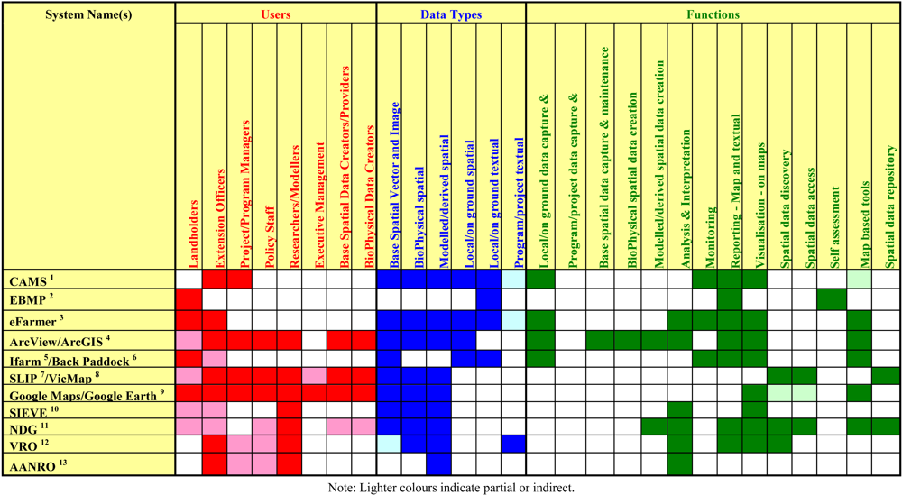
4.1. Review of Existing Agricultural and NRM Software/Data Repositories to Inform EASY Concept Design

Given the need to build on strengths of existing systems, workshop participants were asked to discuss existing software or data repositories that were used to provide information for groups within or outside their organisation. A ‘SWOT’ (Strengths, Weaknesses, Opportunities, Threats) analysis was then applied to these existing approaches as a way to inform EASY concept design.
In all, workshop participants were presented with a list of 17 different existing systems available for NRM and agricultural applications. The strengths of these systems included that many were available at no charge via the Web, had high value as extension tools, were built on existing knowledge and assisted in communication among landholders, extension staff and researchers. Perceived weaknesses of the current systems included limited data coverage, little or no opportunity for two-way information sharing—i.e., farmer feedback, inclusion of recent scientific results, varying data quality, lack of integration of data—and that landholders needed greater support to interpret the information on these systems. Workshop participants felt there were many opportunities to develop a system that provides better linkage among a number of existing complementary web-based systems, caters to a wider range of end-users, improves data sharing with better environmental metrics, and provides for two-way information exchange.
A selection of 11 of these existing systems is presented in Table 1. In general, softwares designed to support mapping applications and spatial data display (e.g., ArcInfo™ and GoogleEarth™) have strengths in data visualisation and database management, and support a wide range of users. However, the generic mapping capability targeted by such software means that the resulting softwares do not have embedded strengths for farm and landscape management. Those that have a primary focus of farm and landscape management (e.g., ifarm™, Back Paddock™) provide strong support for specific farm and landscape management activities. However, their farm application specificity can limit their adaptability and capacity to meet the needs of a wide range of users—a limitation that the EASY project specifically wanted to overcome. Data repositories—for example, Victorian Resources Online [22] and the Western Australian Shared Land Information Portal—provide access to critical data, but do not provide the capability to link datasets in ways that may improve their value for farm and landscape management.

4.2. Development of Broad Principles and Vision for EASY Concept

4.2.1. Broad Principles for EASY Concept Design

In order to develop some broad principles for the EASY concept design, workshop participants were asked what extension tasks the system could be used for, who would use the system, and what the overall objectives of such a system should be.
Participants envisioned that the EASY system would provide a web-based application where communities of extension staff, landholders, researchers and program managers could collaborate through the publishing and sharing of spatial and related information for agricultural planning and management. It was suggested by several participants that the system should be applicable across Australia at various spatial scales, and usable by a variety of individuals, governments and non-government organisations. Another important principle was that the basic EASY system should be freely available.
The importance of the EASY system as an “information conduit,” “facilitator for effective knowledge transfer,” and for “two-way information sharing” between landholders and researchers/extension staff was a consistent theme among workshop participants; lack of such an ability was also noted as a barrier to DSS adoption in the literature cited in the Introduction. It was suggested that researchers and agricultural and natural resource managers could publish spatial datasets, models and other textual information using EASY. Further to this, landholders and extension staff should be able to easily access EASY to find, view, analyse and download published information for improving the productivity and sustainability of agricultural land management practices. The ability for researchers, extension staff and catchment management organisations to compile monitoring information was also considered to be an important feature.

4.2.2. EASY Vision Statement

Based on the broad principles suggested by workshop participants, an EASY concept vision was developed to encompass these themes:
“EASY will be a freely available, open, extensible online system where researchers, agricultural program managers, agricultural consultants, extension staff and landholders create and exchange spatial and other information for use in agricultural planning and management. EASY will be a platform that enables collaborative knowledge-building for improving the productivity and sustainability of agricultural practice.”

4.3. Establishing the EASY System Characteristics

This section outlines the potential users of the EASY system and their potential needs and requirements, thus establishing the system characteristics.

4.3.1. Potential Users

Four major user groups of EASY were envisioned. The major end-users were landholders who would use EASY as a farm management tool. In addition to accessing spatial information and datasets, to this group EASY would provide access to textual documents (e.g., extension notes, relevant research articles and technical reports) concerning improving farm productivity and environmental performance. This capability could be developed by cross-referencing existing online knowledge repositories such as VRO and value-adding to existing knowledge hubs. Landholders may also use purpose-built topic packages and view spatial data and modelling results relevant to their own farm context. Importantly, landholders could also contribute aggregated information to data repositories relevant to farm management activities and regionally-based or industry-based environmental monitoring.
Extension officers and agricultural consultants were another major end-user identified. Given that the key role of agricultural extension activities is the provision of information to landholders, EASY would be an ideal way to disseminate information that landholders can then apply to their own farm context. Another useful role for EASY is as a way to collect information about on-ground activities that would allow extension staff to better understand/monitor the uptake of new land management practices and standards.
The third major user group identified was regional environmental managers (such as CMA staff) and agricultural program managers who could use the topic package functionality extensively. Topic packages (or additional modules related to specific NRM or agricultural topics) could be developed to package specific information and to analyse and report on data collected in EASY. Importantly, this information would include what has been input by landholders, extension officers, and agricultural consultants with over-arching privacy/access arrangements.
Finally, researchers could use EASY to deliver research outcomes and materials to landholders, extension officers and agricultural consultants. EASY would provide a platform where models and research outcomes could be documented, published and accessed by extension officers and agricultural consultants to run “what if?” scenarios to examine potential land management practices. EASY would therefore be a vehicle by which research results contribute to practical real-world outcomes.
Striving to meet these different needs was seen by the EASY project team as a way to enhance uptake. As noted, much work in agricultural DSSs is focussed on a single user-group or application. Using a system-based approach to DSS design was seen as the best way of developing a system that could meet the needs of multiple users by virtue of having an inherently flexible and expandable structure.

4.3.2. System Characteristics Based on User Needs and Requirements

Workshop participants were asked to describe the functions and attributes they required from the EASY system. First, it was envisioned that the web-based system should be applicable to all Australian states at a range of geographic scales and for a wide range of organisational jurisdictions. Further to this, EASY should be highly extensible and customisable, following a modular, component-based design where datasets and functions could be added and configured for specific users, groups and locations. EASY should also suit both non-technical and more sophisticated users. At its core EASY should be a modern, highly interactive web-mapping client with associated content creation tools and social media components to enable collaboration and information sharing.
One of the key requirements to emerge from the workshops was that the proposed system should have a “base package” that would provide the core spatial datasets, aerial photography and map viewing and printing functions for all users. Additional “topic packages” could then be added to enable datasets and related textual information to be linked or packaged, so that these are fit-for-purpose for specific extension-related activities. Topic packages are the mechanism by which single-theme DSSs can be incorporated into the EASY structure.
All users of EASY would have access to a base package of data and functions and it would provide context for all other functions in the application. Users would be able to view an aerial image of their property, and view base spatial datasets such as topography, cadastre, hydrology and relief. The base package would also provide sketch tools to allow landholders to define features of interest and property boundaries. The base package would also include a print function to allow landholders to print a map of their property.
Additional “topic packages” would be designed for a specific agricultural management activity, and optionally for a specific geographic location or organisational jurisdiction. Figure 2 shows a conceptual diagram of the base package and topic packages including their datasets and functions and the two main groups of users (researchers/NRM managers plus extension officers, industry groups and landholders) interacting with those packages.
It as proposed that each topic package could be focused on addressing a specific agricultural management issue or extension program. To illustrate this, one of the case study topic packages developed as part of the EASY project addressed the need to monitor land cover change over time. It provided for the viewing and reporting of multi-temporal data.
A topic package would consist of a range of information types including existing spatial datasets, time series remotely sensed images and model-derived products, executable computer-based models, web pages and other published documents. For example, the multi-temporal prototype topic package was based on manipulation and summarising of a series of remotely sensed images that were part of the EASY base package, but linked through the topic package created. The intention of a topic package is that all information required by extension officers, agricultural consultants and landholders to address a farm land management issue (e.g., magnitude, location, and type of landcover change) would be available from a single web-accessible location. Modelled and other spatial datasets would be supplied in the context of supporting information within a single topic package customised for specific agricultural industries and would include instructions and guidelines for use.
A topic package would be created by a program manager using the content creation tools supplied in EASY to create new web pages, upload documents and images, and create links to existing spatial datasets. It is envisioned that these content creation tools would be easy to use by non-technical users, with functionality similar to existing web content management tools.
Existing spatial datasets included in a specific topic package may be hosted in other accessible systems such as the National Data Grid [31] or government spatial data libraries, or EASY may provide its own upload and storage functions for contributed datasets. EASY is envisioned to re-publish other publicly accessible datasets, primarily via open standards web mapping services, which are becoming more prevalent in supporting spatial data infrastructures.
EASY would provide tools for extension program managers and researchers to create new datasets to which end-users could contribute. Extension staff, consultants and landholders would be able to publish their own local monitoring information and to provide feedback on published spatial datasets and models by contributing to these datasets through a crowd-sourcing approach. Over time these user-contributed datasets would become valuable sources of local information and potentially useful in the validation of research models and published spatial datasets.
Figure 2. EASY functional areas and user groups based on topic package concept established to support industry customisation. For example, topic package for dairy, livestock or horticultural industries.
Futureinternet 04 00042 g002
Figure 3. Users, functions, and topic packages in EASY.
Futureinternet 04 00042 g003

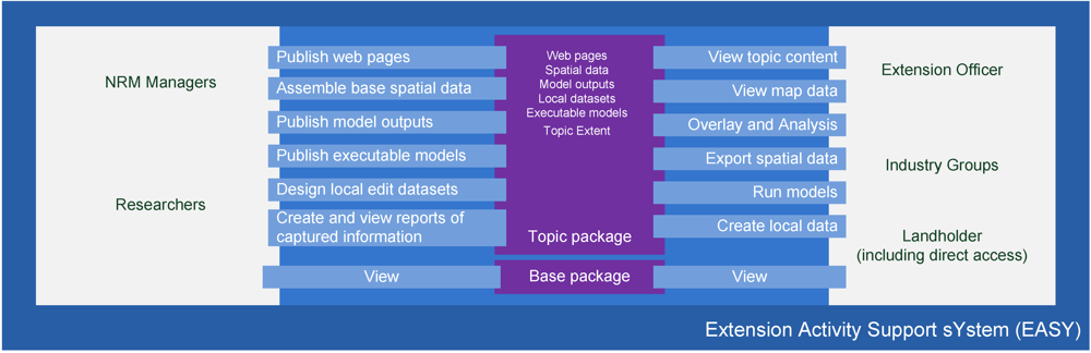
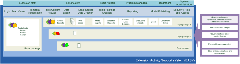
4.4. EASY Concept Design Details: System Functionality for Different Users

The workshops provided an excellent foundation for identifying potential EASY users and the specific functions required of the system by different users. As illustrated in Figure 3 within EASY there would be different functions for extension staff, landholders, topic authors, program managers, researchers and system administrators. Workshop participants suggested that different users should also have differing levels of access.
The functionality of EASY would be accessed and contributed by two general categories of users as well as supporting generalized system management functionality. Each of these user categories is described in turn.

4.4.1. Researcher/Program Manager Functions

4.4.1.1. Content Authoring and Packaging of Information

A key requirement described by workshop stakeholders was the need to make information more integrated and focused upon specific extension delivery tasks. Though considerable research and other agricultural management information exists, this information was considered to be not easily accessible and not in a format useful for extension delivery activities. A clear role for EASY would be to support the grouping of spatial datasets, textual web-based content, modelled outputs, executable models, and spatial datasets as topic packages that include all of the information needed by extension officers, agricultural consultants and landholders to complete a specific agricultural extension activity. Where possible, EASY should be designed to enable non-technical users to create topic packages and publish information. Moreover, where there are existing information systems, EASY should integrate with those systems rather than duplicating their functionality.

4.4.1.2. Provision of Executable Models

Few environmental and process models used in agricultural and environmental planning and management have existing web-accessible interfaces or programming interfaces. Unlike other spatial information services such as the Open GIS web services—web mapping service (WMS) and web feature service (WFS), standards for interacting with environmental and landscape models do not exist or have not been widely adopted.
For relatively simple models, EASY will facilitate the development of interfaces and services to allow end-users to directly interact and create new outputs. While these models may still be run externally to the EASY system, the EASY application will provide the necessary user interface and services for interacting with the outputs of the models and/or the models themselves. An efficient solution for EASY to provide modelling functionality would be for other existing systems to host the models. EASY could then be designed to link through a published web service to the model outputs and in some cases inputs. For example the National Data Grid (NDG) prototype cited earlier already provides a sophisticated web-enabled data storage, visualisation and modelling environment for raster spatial datasets including modelled inputs and outputs. For raster data then it may be most efficient for EASY to provide a linking interface to the NDG system via open source web mapping services, so that raster modelling outputs can be visualised and queried within the EASY user interface.

4.4.1.3. Provision of Modelled Outputs

For highly complex models, it is more likely that EASY would be used to publish model outputs rather than directly hosting interfaces for capturing input parameters and directly executing them. EASY would provide facilities to publish model outputs and link those outputs to other background information that would explain how the model outputs were created, how they should be used, and their general context. These model outputs would be a set of spatial datasets and potentially one or more web pages or documents that describe the modelling process and possibly expert interpretations of model outputs. EASY would provide the repository, documentation and viewing tools with the aim of making the research outputs fit for use by extension staff, landholders and other organisations.

4.4.1.4. Provision of Remotely Sensed Products and Temporal Change Datasets

Analysis of changes in landscape and resource condition will be a key requirement of future farming enterprises. The ability to publish series of datasets for an area and to provide tools to visualise and report on changes in those datasets will be a key component of many extension activities. In particular, the base package of EASY is anticipated to have functions that allow for the publishing, analysis, visualisation and reporting of key remote sensing based indicators that will be regularly updated over time.

4.4.1.5. Create Template Datasets and Data Capture Tools

Researchers and program managers will be able to define and create custom datasets tailored for the specific data collection needs of a topic package. For example if a researcher has published a model output that is being used on a farm they will be able to configure a related dataset capable of collecting primary resource condition monitoring that could be used to further inform future runs of the model and validate its results.

4.4.2. Extension Officer, Consultant, Landholder Functions

4.4.2.1. Security and Access Control

EASY would support both direct access by landholders and, where required, extension-officer-facilitated access to information through highly configurable levels of security and access control. Though the base information packages are envisioned to be available to all users, access protocols would facilitate targeting of individual topic packages to user groups that are participating in specific targeted extension programs or activities.

4.4.2.2. Searching and Information Discovery

EASY would provide a single place for landholders to search for spatial datasets and related textual information that are specifically relevant to their location and to the land management topic in which they are interested.

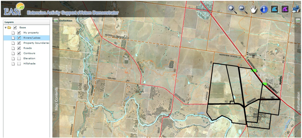
4.4.2.3. Map Viewing, Query and Printing of Base Datasets

It is envisioned that EASY will be an online location where landholders can easily view basic aerial and topographic information about their properties through unfettered access to the base functions and datasets. EASY would provide basic tools for landholders to view spatial data, measure areas and distance, record their own features of interest and print maps of their property or region.

4.4.2.4. Data Editing

Workshop participants described a range of base functionality that EASY should include such as polygon, line and point sketch tools printing and basic map viewing (e.g., zoom, pan, print) so that landholders can define their property boundaries, measure paddock areas and print a map of the property for use in planning and discussions with extension officers and other stakeholders. Definition of property boundaries would also enable access to models and their outputs with the geographic extent of information provided controlled through access protocols.

4.4.2.5. Data Download

In some cases existing desktop software will continue to be used by landholders. For such systems EASY will provide functions to export spatial datasets in an interoperable format and make them available for use in desktop software packages.

4.4.2.6. Temporal Viewing and Analysis Tools

Time series remotely sensed information is increasingly being used in agricultural planning and management. Monitoring and analysis of changes in resource conditions through the visualisation and reporting on a time series of remotely sensed images would be a key base package requirement for EASY. More sophisticated temporal analysis could be provided through the development of topic packages. Though this was implemented as a prototype topic package for demonstration purposes in the EASY project (see Figure 4), it is anticipated that some capacity for temporal analysis and viewing would be included as part of the EASY base package functionality.

4.4.2.7. Reporting

A key requirement of program managers is to report on the amount of activity and outcomes achieved by an extension program. A proposed EASY base package template dataset where program managers could configure new datasets for collecting information from landholders would provide a means to report on extension program outcomes.
Figure 4. EASY prototype topic package with aerial imagery and polygonal data illustrating property boundaries, water courses and road networks.
Futureinternet 04 00042 g004

4.4.2.8. Contributed Observational and Monitoring Information

Landholders, extension officers, and agricultural consultants would be able to contribute to EASY their own local observations and activity records to EASY. EASY would allow these users to create new datasets for capturing primary observational and monitoring information. Landholders could then contribute their own observations to these datasets using EASY, thereby supplementing existing published datasets with more local and specific environmental information.

4.4.3. General System Functionality

As with all information systems, a certain number of administrative functions and capabilities would be required.

4.4.3.1. Connections and Accessibility

As a web-based mapping application EASY would be designed for a minimum connection speed of 256 kbps to be adequately responsive to end-users due to the size of the graphical outputs of mapping applications. However, with broadband internet becoming more mainstream even in rural and remote areas it is anticipated that the system would be scaleable and be able to benefit from increased bandwidth when available.

4.4.3.2. Usability and Expertise

As much as possible EASY would be designed to allow non-technical users to create content as well as topic packages on the system. The content management tools, data upload functions and editing tools provided in EASY would be of a similar functionality to existing web content management systems. EASY would be designed to allow users to contribute and use content without necessarily having programming or other highly specific computer experience. Social media components, which are easy to use by non-technical users, would be implemented as much as possible. This would include supporting postings through tools such as Wikis and blogs and micro-blogs.

4.4.3.3. Customisation and Extensibility

Workshop participants were very keen for EASY to be designed as a nationally applicable system that should support a wide variety of users and extension activities. A key requirement would be that the system be configurable and extensible by the actual users of the system. For example program managers would need to be able to build information packages for specific extension related tasks. EASY will be highly configurable—its content, functions and interactions will change over time according to the needs of end-users.

4.4.3.4. Access and Security

Confidentiality and varying levels of access among different user groups was a key issue raised during consultation. EASY should provide a fine-grained approach to securing access for different user groups. Some functions such as the base map viewing and query functions would be available to all registered users of the EASY system, whereas other more specialised extension programs would have access configured by the program manager targeting specific groups of landholders.

4.5. Data and Information

The proposed system will need to support a wide variety of information types, including spatial data and standard web page content. It will need to host its own spatial datasets, web pages and models as well as be able to communicate and interface with other external systems.

4.5.1. Spatial Data

EASY will need to be able to integrate a wide range of data sources including open standards based systems and the main proprietary spatial datasets that are commonly used by government and large organisations. It will need to work with the many existing published services including web mapping services, web feature services, and other proprietary web-based products as needed.

4.5.1.1. Dataset Externally Hosted—OpenGIS Services—Client and Server

Web Mapping Services that are already published by other organisations will be able to be consumed by the EASY system. It will be possible to add these datasets to the main map viewing functionality of the EASY system. Vector data viewing and querying will be provided by Web Feature Service functionality in the EASY system. Web Coverage Service will provide raster querying and modelling functionality. The publishing of datasets hosted by EASY to WMS, WFS and WCS services is another possible function of EASY that will be achieved by utilising one of the available GIS server applications available in the marketplace.
Where EASY will be exchanging information with other systems, open standards (for example, Open Geospatial Consortium (OGC)) will be used as much as possible.

4.5.1.2. Hosted Spatial Datasets

EASY will provide a function for researchers and program managers to upload and host all main spatial datasets including image, raster and vector types.

4.5.2. Hosted Non-Spatial Datasets

EASY will include the ability to host or cross-reference non-spatial information such as technical reports, AgNotes/fact sheets, and other relevant documentation designed for end-user communication. Though these will ostensibly have no spatial reference, the ability to include an implicit spatial reference will be present in EASY. For example, extension notes targeting dairy farming will have the facility to be linked to a specific dairy farming topic package.

5. Discussion

As noted, a considerable amount of effort has been expended to create DSSs that would meet the needs of those involved in the agricultural sector. It was similarly noted that the uptake of DSSs was limited. Whereas many agricultural DSSs have been produced from the perspective of meeting specific agricultural needs, the EASY project sought to overcome problems of DSS uptake by designing an agricultural DSS using a system-focused approach. A system-based approach was used to overcome the potential for “technology/science push” rather than end-user need. This was seen as critical given that as recently as 2005, most scientific literature on DSS development had not identified the clients or end-users of a reported DSS [32].
The work of [28] is highly relevant to the system-focused approach used to design EASY. Those researchers used literature review, consultations of developers, and surveys of research, development, delivery and funding stakeholders involved in agricultural DSS to determine if consensus principles about DSS design and development could be identified. A summary of their findings that are relevant to the EASY project are:
  • To succeed, agricultural DSSs require involvement and continual improvement by farmers, agricultural consultants, and researchers.
  • The goal of agricultural DSSs should not be to produce an algorithmically optimal solution, but instead should enable users to arrive at individually designed solutions based on a combination of data, experience, and intuition.
  • A delivery plan must be an integral part of DSS creation. The delivery plan should involve developers and scientists as well as end-users and must include a funding plan that will maintain the DSS beyond initial delivery.
The system-based approach adopted for the design of EASY addresses the involvement of multiple stakeholders. Consultations included a wide range of individuals from various sectors to ensure a balance between developer/researcher concepts and end-user needs. Continual improvements would result from two activities. First, the ability to create topic packages would ensure that the functionality of the EASY system would continue to grow. This would undoubtedly lead to a need to increase base functionality and databases. Hence the second way that EASY would grow would be to identify and support an EASY custodian who would have responsibility for EASY maintenance and upgrades; funding of this custodian is discussed subsequently.
The second point of [28] relates to the underlying philosophy of DSSs. Many have been developed to respond to a specific question or problem. Consequently, many have an underlying philosophy of identifying “the best solution” to a specific problem. While this may have enhanced their utility for a specific problem, it has limited their widespread applicability. EASY was designed to avoid this problem while at the same time accommodating problem-specific DSSs. The EASY system would have a core capability, but would also be expandable to support the needs of individual users. We envision an EASY DSS that could include topic packages developed to support the needs of government policy as well as individual farmers. Agricultural consultants would also be able to develop topic packages targeted at individual farm managers and used on a fee-for-service basis.
Finally, the third point of [28] indicates that the development of a sustainable business model is crucial for the success of such an online system. The EASY project team predominantly considered two self-supporting business models.
The first is that EASY be established as a government-supported entity. Because EASY is envisioned as a national system, in Australia a federal agency such as Geoscience Australia, or the Australian Bureau of Agriculture and Rural Economics (ABARE) would be a logical choice for being the host and custodian of the system. Individual States would then have the capability of customizing EASY for their individual data types, agricultural activities, and structure of the agricultural sector. This business model establishes EASY as a public-good entity similar in principle to web-based weather information provided free of charge to the public by the Bureau of Meteorology (BOM) in Australia. It fits well with the concept of EASY not duplicating farm management systems that already exist and instead would provide information and capability that could be enhanced by commercial entities. Three primary difficulties exist with this business model. The first is that the (federal) Government agency that would have the responsibility for hosting EASY would have to receive a substantial new budget allocation to do so; demonstrating the value proposition of a new government funded information system is never an easy task. This relates to the second major difficulty with this business model. To get support for a Federal budget allocation for EASY, individual state/provincial governments would have to agree to a centralized approach to the establishment and maintenance of a farm information system or the federal government would need to agree to a decentralized implementation. Both of these options would have their challenges. Considerable effort would have to be expended to get states/provinces to agree to develop a farm management system founded on a federally funded and hosted web service. Finally, a third potential impediment is the likelihood that a government-hosted system would also be a government-controlled system. Non-governmental EASY stakeholders such as agricultural grower’s groups may be unwilling to encourage member use and support of a system to which they have no input. This could potentially constrain a two way flow of information among farmers, researchers and other key user groups of the system.
The second business model considered was that EASY be established and maintained as a financially sustainable commercial entity. To achieve this, EASY would have to be supported financially by end-users who believe their individual subscription cost represents sufficient value for money. Under this model, end-users could also include government-funded statutory bodies such as CMAs. Another major subscriber would be grower-group consortiums that represent individual landowners/farmers. These are supported financially through levies on sales and include groups like the Australian Citrus Growers, Grain Growers, and Murray-Goulburn Cooperative (dairy). These would subscribe to EASY as part of their operational activities or to provide a service to members. Finally, end-users would also be agricultural consultants who would create topic packages that could be on-sold to individual farmers. Three primary difficulties are seen with this business model. First, many of the data archives required for EASY are publicly held. If they are used in a commercial enterprise, commercial rates would probably apply for their acquisition and use. The costs of core data under such a pricing model could increase the end-user cost to the point where it is considered too expensive for landowner subscribers. The second issue is one of system continuity. Establishing EASY as a commercial entity would require start-up funds and an initial awareness-raising period. However, targeted end-users—particularly landowners/farmers—might be hesitant to commit to using EASY without confidence that EASY will be available in the long-term. Third, for-profit commercial entities are unlikely to establish such an EASY system without a firm time-linked commitment from “anchor” stakeholders, or without difficult-to-obtain risk capital. Hence government entities and grower groups would have to agree to commit financial resources to the establishment and initial maintenance of an EASY system. This might be difficult to achieve, particularly since concern has been expressed about having DSS development and maintenance be market-driven [28].

6. Summary and Conclusions

Though considerable effort has been expended on agricultural DSSs, their uptake has been limited. In part, this has been caused by a “technology/science push” approach to DSS development. This paper suggests that this problem can be improved considerably using a consultative systems-based approach to DSS design.
Such an approach was employed to design EASY—an agricultural DSS that would support the effective and user-driven discovery, publishing and access to a range of information, primarily spatial in nature. This information needs to be easily accessed by individuals involved in the delivery of spatial information in broadly defined “agricultural extension” activities. A logical way to achieve this is by developing a computer-based delivery mechanism reliant on spatial technology that has been designed through an assessment of needs of information providers (researchers and government organisations) and end-users—i.e., extension officers and landholders. The EASY prototype has been developed as a nationally applicable conceptual prototype and related demonstration of such an information system based on representational user requirements analysis. The design was also developed after a survey had been done of existing software systems to eliminate duplication and ensure compatibility with those that are the most useful. This survey also built upon the results of previous desktop scans of farm software [33,34].
The system envisaged enables the ingestion of a large range of information, potentially including vector spatial data, geo-referenced imagery, raster spatial datasets, output from modelling processes, and reports. An operational version of the system would be developed based on a Web 2.0 paradigm allowing for a two way flow of information. Web 2.0 collaboration tools are reported in [35] as a way forward in realising more informed and participatory land use decision-making.
Such a Web 2.0 system would be accessible via a number of means including an API (Application Programming Interface) for automated integration with other software applications and also via a web-delivered user interface that allows extension staff and public agency land management planners to easily discover and extract information for relevant areas and in formats that are directly useable. Such a system would ultimately be compatible with mobile computing devices to support data collection, and more sophisticated GIS tools to support advanced spatial analysis and data visualisation. Extracted data may also be made available to landholders who may use it in existing desktop software tools such as ifarm™. The next steps in Australia are to provide better access to the growing digital datasets that can inform more sustainable and profitable farming practices, and to develop a suitable business model for the long-term support of EASY. The EASY prototype presented in this paper provides a critical next step in spatially enabling Australia’s agricultural sector.

References

  1. McCown, R. Learning to bridge the gap between scientific decision support and the practice of farming: Evolution in paradigms of model-based research and intervention from design to dialogue. Aust. J. Agric. Res. 2001, 52, 549–571. [Google Scholar]
  2. McCown, R.; Parton, K. Learning from the historical failure of farm management models to aid farm management practice. 2. Three systems approaches. Aust. J. Agric. Res. 2006, 57, 157–172. [Google Scholar] [CrossRef]
  3. Ewert, F.; van Ittersum, M.; Bezlepkina, I.; Therond, O.; Andersen, E.; Belhouchette, H.; Bockstaller, C.; Brouwer, F.; Heckelei, T.; Janssen, S.; et al. A methodology for enhanced flexibility of integrated assessment in agriculture. Environ. Sci. Policy 2009, 12, 546–561. [Google Scholar] [CrossRef]
  4. Binder, C.; Feola, G.; Steinberger, J. Considering the normative, systemic, and procedural dimensions in indicator-based sustainability assessments in agriculture. Environ. Impact Assess. Rev. 2010, 30, 71–81. [Google Scholar] [CrossRef]
  5. Bezlepkina, I.; Reidsma, P.; Sieber, S.; Helming, K. Editorial: Integrated assessment of sustainability of agricultural systems and land use: Methods, tools, and application. Agric. Syst. 2011, 104S, 105–109. [Google Scholar]
  6. van Ittersum, M.; Ewert, F.; Heckelei, T.; Wery, J.; Alkan Olsson, J.; Andersen, E.; Bezlepkina, I.; Brouwer, F.; Donatelli, M.; Flichman, G.; Olsson, L.; Rizzoli, A.; van der Wal, T.; Wien, J.; Wolf, J. Integrated assessment of agricultural systems—A component-based framework for the European Union (SEAMLESS). Agric. Syst. 2008, 96, 150–165. [Google Scholar]
  7. Wery, J.; Langeveld, J. Introduction to the EJA special issue on cropping system design: New methods and new challenges. Eur. J. Agron. 2010, 32, 1–2. [Google Scholar]
  8. Cros, M.; Duru, M.; Garcia, F.; Martin-Clouaire, R. A biophysical dairy farm model to evalaute rotational grazing management strategies. Agronomy 2003, 23, 105–122. [Google Scholar]
  9. Moore, A.; Robertson, M.; Routley, R. Evaluation of the water use efficiency of alternative farm practices at a range of spatial and temporal scales: A conceptual framework and a modelling approach. Agric. Syst. 2011, 104, 162–174. [Google Scholar]
  10. CAMS (Catchment Activity Management System) website. Available online: http://www.dse.vic.gov.au/land-management/regional-data-net-catchment-activity-management (accessed on 7 November 2011).
  11. Environmental Farm Plan website. Available online: http://www.environmentalfarmplan.org.au/ (accessed on 7 November 2011).
  12. Roberts, A.; Park, G.; Melland, A.; Miller, I. Trialling a web-based spatial information management tool with Land Managers in Victoria. Aust. J. Environ. Manag. 2009, 91, 523–531. [Google Scholar]
  13. ESRI website. Available online: http://www.esri.com/software/arcgis/arcgis-for-desktop/index.html (accessed on 7 November 2011).
  14. ifarm website. Available online: http://www.eagri.com.au/ (accessed on 7 November 2011).
  15. Back Paddock website. Available online: http://www.backpaddock.com.au/ (accessed on 7 November 2011).
  16. SLIP website. Available online: https://www2.landgate.wa.gov.au/web/guest/home (accessed on 4 January 2012).
  17. VicMap website. Available online: http://www.land.vic.gov.au/ (accessed on 12 May 2011).
  18. GoogleEarth website. Available online: http://earth.google.com/ (accessed on 7 November 2011).
  19. GoogleMaps website. Available online: http://maps.google.com.au/ (accessed on 7 November 2011).
  20. Stock, C.; Bishop, I.; O’Connor, A.; Chen, T.; Pettit, C.; Aurambout, J.-P. SIEVE: Collaboration decision-making in an immersive online environment. Cartogr. Geogr. Inf. Sci. 2008, 35, 133–144. [Google Scholar]
  21. NDG website. Available online: http://www.spatialvision.com.au/index.php/national-data-grid-ndg.html (accessed on November 2011).
  22. VRO website. Available online: http://new.dpi.vic.gov.au/vro (accessed on 7 November 2011).
  23. Australian Agriculture and Natural Resources Online (AANRO). Available online: http://www.rgc.org.au/knowledgebase/AANRO (accessed on 7 November 2011).
  24. Lacy, J. Cropcheck: Farmer benchmarking participatory model to improve productivity. Agric. Syst. 2011, 104, 562–571. [Google Scholar]
  25. Vaysières, J.; Vigne, M.; Alary, V.; Lecomte, P. Integrated participatory modeling of actual farms to support policy making on sustainable intensification. Agric. Syst. 2011, 104, 146–161. [Google Scholar]
  26. le Gal, P.-Y.; Dugué, P.; Faure, G.; Novak, S. How does research address the design of innovative agricultural production systems at the farm level? A review. Agric. Syst. 2011, 104, 714–728. [Google Scholar]
  27. Giller, K.; Leeuwis, C.; Andriesse, W.; Brouwer, A.; Frost, P.; Hebinck, P.; Heikonig, I.; van Ittersum, M.; Koning, N.; Rubne, R.; et al. Competing claims on natural resources: What role for science? Ecol. Soc. 2008, 13, p. 34. Available online: http;//www.ecologyandsociety.org.vol13/ iss2/art34 (accessed on 7 November 2011).
  28. Hochman, Z.; Carberry, P. Emerging consensus on desirable characteristics of tools to support farmers’ management of climate risk in Australia. Agric. Syst. 2011, 441–450. [Google Scholar]
  29. le Gal, P.-Y.; Mérot, A.; Moulin, C.; Navarrete, M.; Wery, J. A modeling framework to support farmers in designing innovative agricultural production systems. Environ. Model. Softw. 2010, 25, 258–268. [Google Scholar]
  30. Thysen, I. Agriculture in the information society. J. Agric. Eng. Res. 2000, 76, 297–303. [Google Scholar]
  31. Chan, T.; Farrell, S.; Frankish, G. The National Data Grid: A Development Model for Grid Cell Data Infrastructure. In Proceedings of the FIG Congress 2010 (International Federation of Surveyors), Sydney, Australia, 11–16 April 2010.
  32. Arnott, D.; Pervan, G. A critical analysis of decision support systems research. J. Inf. Technol. 2005, 20, 67–87. [Google Scholar]
  33. Cartwright, W. Desktop Analysis and Review of Spatial Information Products and Technologies that have Application at the Farm and Catchment Scale; Report to the Department of Primary Industries, DPI: Melbourne, Australia, 2007.
  34. Fitzpatrick, B.; Neale, T. Overview of Farm Mapping Software in Australia, Rural Industries Research and Development Corporation; RIRDC Publication No 08/038, Project No CTF-1A; Rural Industries Research and Development Corporation: Kingston (ACT), Australia, 2008.
  35. Pettit, C.J.; Cartwright, W.; Bishop, I.; Park, G.; Kemp, O. Enhancing Web-Based Farm Management Software Through the Use of Visualisation Technologies. In Proceedings of the MODSIM07: International Congress on Modelling and Simulation, Christchurch, New Zealand, 10–13 December 2007.

