Prediction of Forest Canopy and Surface Fuels from Lidar and Satellite Time Series Data in a Bark Beetle-Affected Forest

 ,
,  , ,
, ,
Abstract
:1. Introduction
2. Materials and Methods
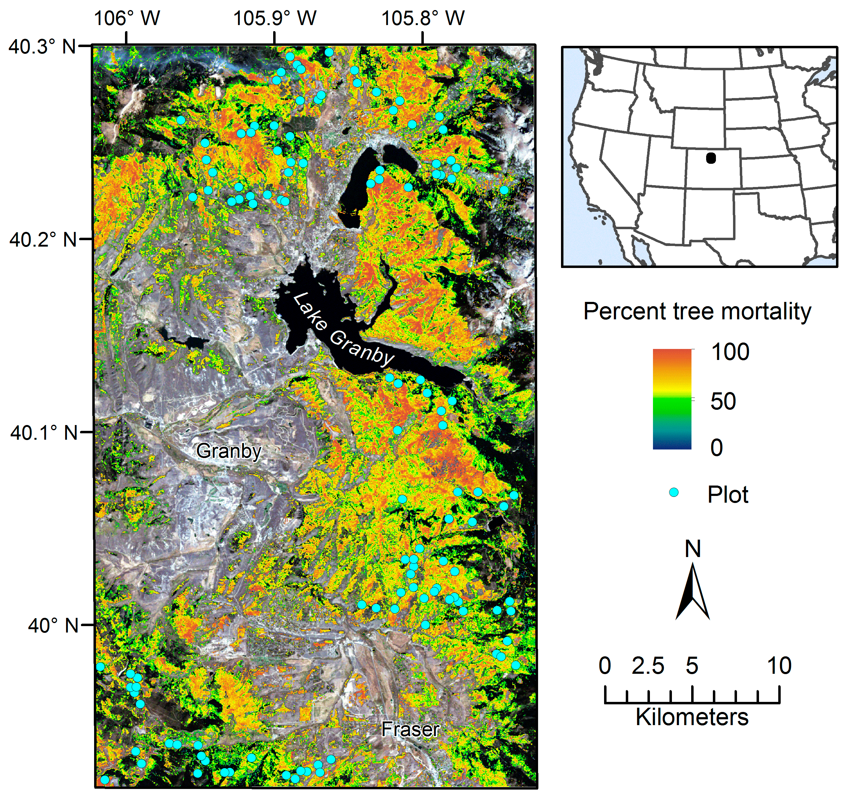
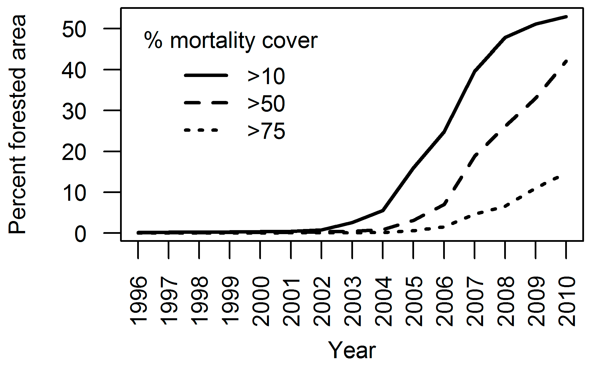
2.1. Study Area
2.2. Field Observations
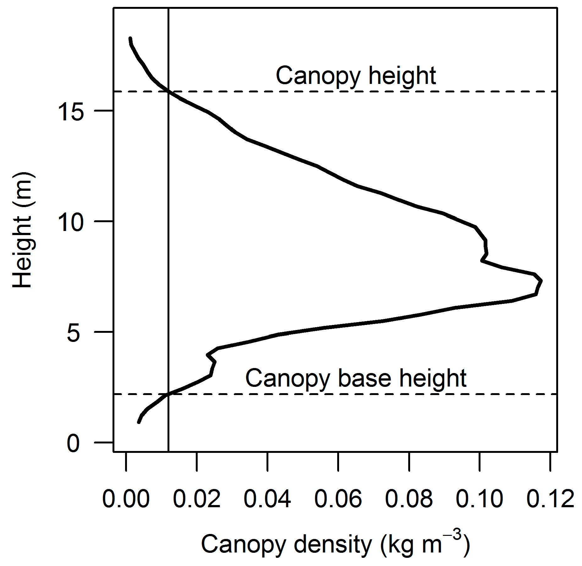
2.3. Canopy Fuel Estimation
2.4. Remote Sensing Data
2.4.1. Lidar
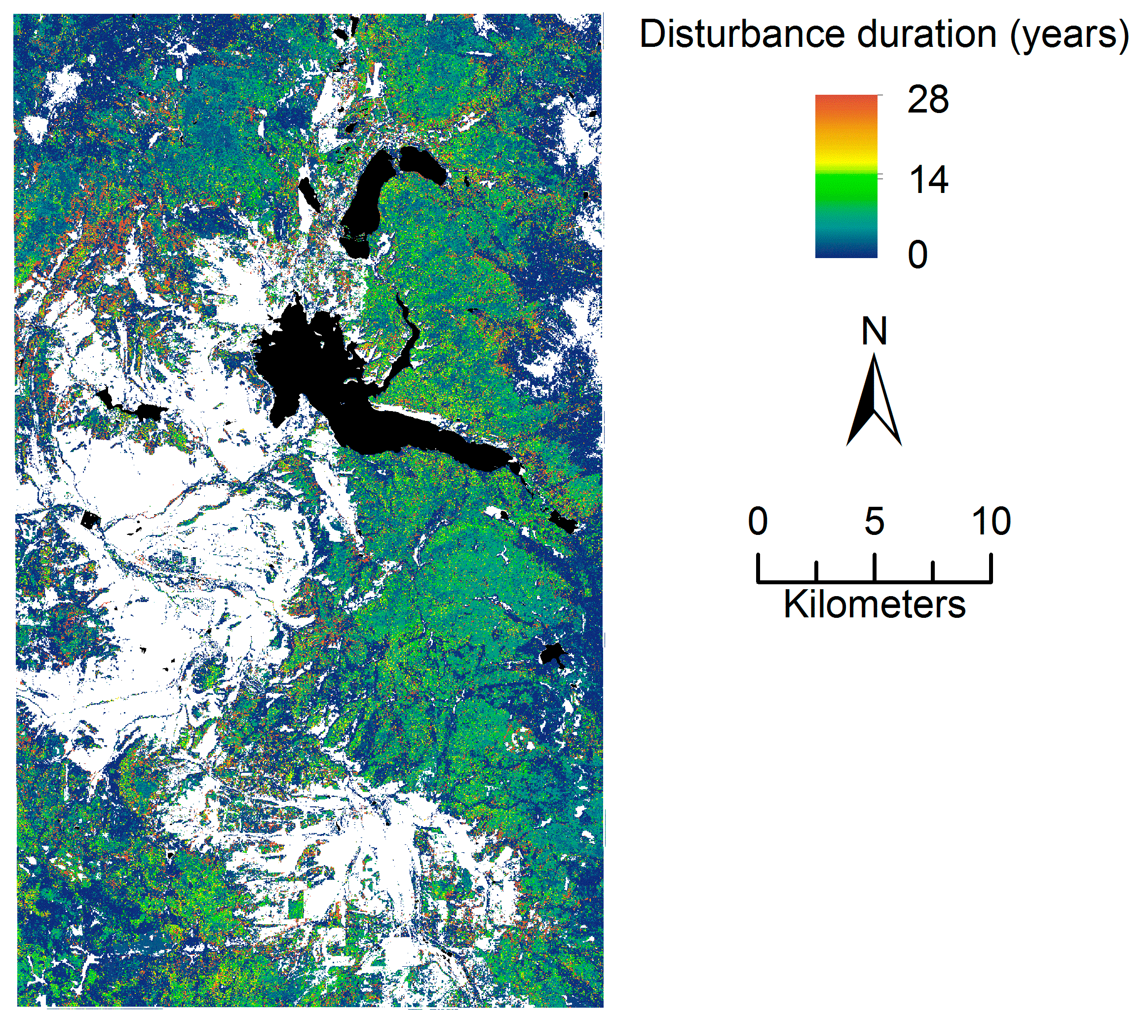
2.4.2. Landsat Time Series
2.4.3. Aerial Detection Survey
2.5. Random Forest Modeling
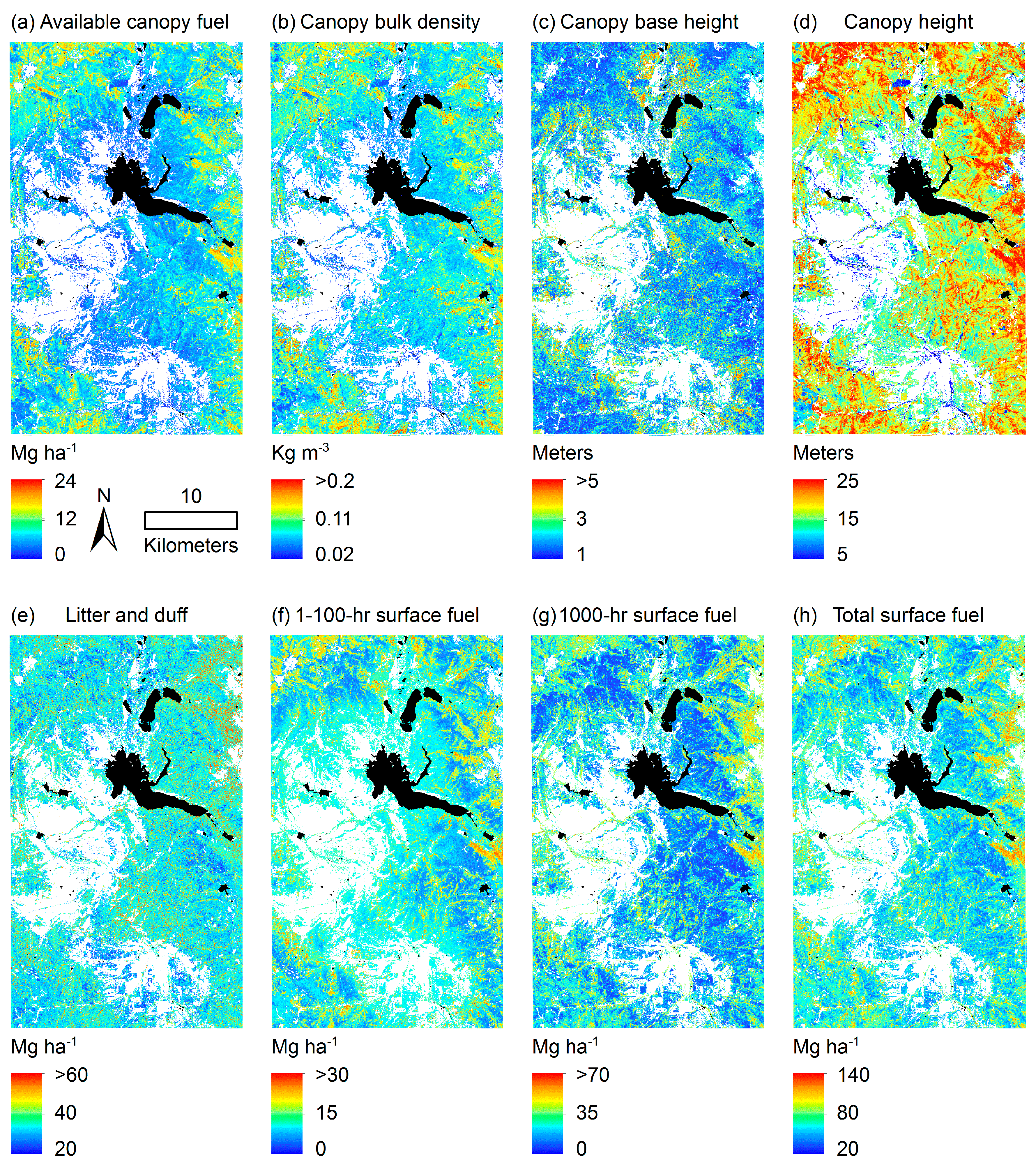
3. Results
4. Discussion
5. Conclusions
Acknowledgments
Author Contributions
Conflicts of Interest
References
- Littell, J.S.; McKenzie, D.; Peterson, D.L.; Westerling, A.L. Climate and wildfire area burned in western U.S. ecoprovinces, 1916–2003. Ecol. Appl. 2009, 19, 1003–1021. [Google Scholar] [CrossRef]
- Allen, C.D.; Macalady, A.K.; Chenchouni, H.; Bachelet, D.; McDowell, N.; Vennetier, M.; Kitzberger, T.; Rigling, A.; Breshears, D.D.; Hogg, E.H.; et al. A global overview of drought and heat-induced tree mortality reveals emerging climate change risks for forests. For. Ecol. Manag. 2010, 259, 660–684. [Google Scholar] [CrossRef]
- Meddens, A.J.H.; Hicke, J.A.; Ferguson, C.A. Spatiotemporal patterns of observed bark beetle-caused tree mortality in British Columbia and the western United States. Ecol. Appl. 2012, 22, 1876–1891. [Google Scholar] [CrossRef]
- Dale, V.H.; Joyce, L.A.; McNulty, S.; Neilson, R.P.; Ayres, M.P.; Flannigan, M.D.; Hanson, P.J.; Irland, L.C.; Lugo, A.E.; Peterson, C.J.; et al. Climate Change and Forest Disturbances: Climate change can affect forests by altering the frequency, intensity, duration, and timing of fire, drought, introduced species, insect and pathogen outbreaks, hurricanes, windstorms, ice storms, or landslides. BioScience 2001, 51, 723–734. [Google Scholar] [CrossRef]
- Westerling, A.L.; Hidalgo, H.G.; Cayan, D.R.; Swetnam, T.W. Warming and Earlier Spring Increase Western U.S. Forest Wildfire Activity. Science 2006, 313, 940–943. [Google Scholar] [CrossRef] [PubMed]
- Bentz, B.J.; Régnière, J.; Fettig, C.J.; Hansen, E.M.; Hayes, J.L.; Hicke, J.A.; Kelsey, R.G.; Negrón, J.F.; Seybold, S.J. Climate Change and Bark Beetles of the Western United States and Canada: Direct and Indirect Effects. BioScience 2010, 60, 602–613. [Google Scholar] [CrossRef]
- Riley, K.L.; Loehman, R.A. Mid-21st-century climate changes increase predicted fire occurrence and fire season length, Northern Rocky Mountains, United States. Ecosphere 2016, 7, e01543. [Google Scholar] [CrossRef]
- Abatzoglou, J.T.; Williams, A.P. Impact of anthropogenic climate change on wildfire across western US forests. Proc. Natl. Acad. Sci. USA 2016, 113, 11770–11775. [Google Scholar] [CrossRef] [PubMed]
- Agee, J.K. Fire Ecology of Pacific Northwest Forests, 1st ed.; Island Press: Washington, DC, USA, 1993; pp. 25–52. [Google Scholar]
- Agee, J.K.; Skinner, C.N. Basic principles of forest fuel reduction treatments. For. Ecol. Manag. 2005, 211, 83–96. [Google Scholar] [CrossRef]
- Scott, J.; Reinhardt, E. Assessing Crown Fire Potential by Linking Models of Surface and Crown Fire Behavior; Research Paper RMRS-RP-29; U.S. Department of Agriculture, Rocky Mountain Research Station: Fort Collins, CO, USA, 2001; 59p.
- Lutes, D.; Heward, H.; Keane, R.; Scott, J.; Gangi, L. FuelCalc User’s Guide (version 1.2.0). Available online: https://www.firelab.org/project/fuelcalc (accessed on 12 March 2015).
- Lefsky, M.A.; Cohen, W.B.; Parker, G.G.; Harding, D.J. Lidar Remote Sensing for Ecosystem Studies. BioScience 2002, 52, 19–30. [Google Scholar] [CrossRef]
- Hudak, A.T.; Evans, J.S.; Smith, A.M.S. LiDAR Utility for Natural Resource Managers. Remote Sens. 2009, 1, 9349–9351. [Google Scholar] [CrossRef]
- Eitel, J.U.H.; Höfle, B.; Vierling, L.A.; Abellán, A.; Asner, G.P.; Deems, J.S.; Glennie, C.L.; Joerg, P.C.; LeWinter, A.L.; Magney, T.S.; et al. Beyond 3-D: The new spectrum of lidar applications for earth and ecological sciences. Remote Sens. Environ. 2016, 186, 3723–3792. [Google Scholar] [CrossRef]
- Huang, C.; Goward, S.N.; Masek, J.G.; Thomas, N.; Zhu, Z.; Vogelmann, J.E. An automated approach for reconstructing recent forest disturbance history using dense Landsat time series stacks. Remote Sens. Environ. 2010, 114, 183–198. [Google Scholar] [CrossRef]
- Kennedy, R.E.; Yang, Z.G.; Cohen, W.B. Detecting trends in forest disturbance and recovery using yearly Landsat time series: 1. LandTrendr—Temporal segmentation algorithms. Remote Sens. Environ. 2010, 114, 2897–2910. [Google Scholar] [CrossRef]
- Banskota, A.; Kayastha, N.; Falkowski, M.J.; Wulder, M.A.; Froese, R.E.; White, J.C. Forest Monitoring Using Landsat Time Series Data: A Review. Can. J. Remote Sens. 2014, 40, 3623–3684. [Google Scholar] [CrossRef]
- Falkowski, M.J.; Gessler, P.E.; Morgan, P.; Hudak, A.T.; Smith, A.M.S. Characterizing and mapping forest fire fuels using ASTER imagery and gradient modeling. For. Ecol. Manag. 2005, 217, 129–146. [Google Scholar] [CrossRef]
- Lasaponara, R.; Lanorte, A. Remotely sensed characterization of forest fuel types by using satellite ASTER data. Int. J. Appl. Earth Obs. Geoinform. 2007, 9, 225–234. [Google Scholar] [CrossRef]
- Andersen, H.E.; McGaughey, R.J.; Reutebuch, S.E. Estimating forest canopy fuel parameters using LIDAR data. Remote Sens. Environ. 2005, 94, 4414–4449. [Google Scholar] [CrossRef]
- Hall, S.A.; Burke, I.C.; Box, D.O.; Kaufmann, M.R.; Stoker, J.M. Estimating stand structure using discrete-return lidar: An example from low density, fire prone ponderosa pine forests. For. Ecol. Manag. 2005, 208, 189–209. [Google Scholar] [CrossRef]
- Skowronski, N.; Clark, K.; Nelson, R.; Hom, J.; Patterson, M. Remotely sensed measurements of forest structure and fuel loads in the Pinelands of New Jersey. Remote Sens. Environ. 2007, 108, 123–129. [Google Scholar] [CrossRef]
- Popescu, S.C.; Zhao, K. A voxel-based lidar method for estimating crown base height for deciduous and pine trees. Remote Sens. Environ. 2008, 112, 767–781. [Google Scholar] [CrossRef]
- Dean, T.J.; Cao, Q.V.; Roberts, S.D.; Evans, D.L. Measuring heights to crown base and crown median with LiDAR in a mature, even-aged loblolly pine stand. For. Ecol. Manag. 2009, 257, 126–133. [Google Scholar] [CrossRef]
- Vauhkonen, J. Estimating crown base height for Scots pine by means of the 3D geometry of airborne laser scanning data. Int. J. Remote Sens. 2010, 31, 1213–1226. [Google Scholar] [CrossRef]
- Skowronski, N.S.; Clark, K.L.; Duveneck, M.; Hom, J. Three-dimensional canopy fuel loading predicted using upward and downward sensing LiDAR systems. Remote Sens. Environ. 2011, 115, 703–714. [Google Scholar] [CrossRef]
- Hermosilla, T.; Ruiz, L.A.; Kazakova, A.N.; Coops, N.C.; Moskal, L.M. Estimation of forest structure and canopy fuel parameters from small-footprint full-waveform LiDAR data. Int. J. Wildland Fire 2014, 23, 224–233. [Google Scholar] [CrossRef]
- González-Ferreiro, E.; Diéguez-Aranda, U.; Crecente-Campo, F.; Barreiro-Fernández, L.; Miranda, D.; Castedo-Dorado, F. Modeling canopy fuel variables for Pinus radiate D. Don in NW Spain with low-density LiDAR data. Int. J. Wildland Fire 2014, 23, 350–362. [Google Scholar] [CrossRef]
- Kramer, H.A.; Collins, B.M.; Kelly, M.; Stephens, S.L. Quantifying Ladder Fuels: A New Approach Using LiDAR. Forests 2014, 5, 1432–1453. [Google Scholar] [CrossRef]
- Price, O.F.; Gordon, C.E. The potential for LiDAR technology to map fire fuel hazard over large areas of Australian forest. J. Environ. Manag. 2016, 181, 663–673. [Google Scholar] [CrossRef] [PubMed]
- García, M.; Popescu, S.; Riaño, D.; Zhao, K.; Neuenschwander, A.; Agca, M.; Chuvieco, E. Characterization of canopy fuels using ICESat/GLAS data. Remote Sens. Environ. 2012, 123, 81–89. [Google Scholar] [CrossRef]
- Peterson, B.; Nelson, K.; Bruce, W. Towards Integration of GLAS into a National Fuel Mapping Program. Photogram. Eng. Remote Sens. 2013, 79, 175–183. [Google Scholar] [CrossRef]
- Erdody, T.L.; Moskal, L.M. Fusion of LiDAR and imagery for estimating forest canopy fuels. Remote Sens. Environ. 2010, 114, 725–737. [Google Scholar] [CrossRef]
- García, M.; Riaño, D.; Chuvieco, E.; Salas, J.; Danson, F.M. Multispectral and LiDAR data fusion for fuel type mapping using Support Vector Machine and decision rules. Remote Sens. Environ. 2011, 115, 1369–1379. [Google Scholar] [CrossRef]
- Jakubowski, M.K.; Guo, Q.; Collins, B.; Stephens, S.; Kelly, M. Predicting Surface Fuel Models and Fuel Metrics Using Lidar and CIR Imagery in a Dense, Mountainous Forest. Photogram. Eng. Remote Sens. 2013, 79, 37–49. [Google Scholar] [CrossRef]
- Skowronski, N.S.; Haag, S.; Trimble, J.; Clark, K.L.; Gallagher, M.R.; Lathrop, R.G. Structure-level fuel load assessment in the wildland-urban interface: A fusion of airborne laser scanning and spectral remote-sensing methodologies. Int. J. Wildland Fire 2016, 25, 547–557. [Google Scholar] [CrossRef]
- Loudermilk, E.L.; Hiers, J.K.; O’Brien, J.J.; Mitchell, R.J.; Singhania, A.; Fernandez, J.C.; Cropper, W.P.; Slatton, K.C. Ground-based LIDAR: A novel approach to quantify fine-scale fuelbed characteristics. Int. J. Wildland Fire 2009, 18, 676–685. [Google Scholar] [CrossRef]
- García, M.; Danson, F.M.; Riaño, D.; Chuvieco, E.; Ramirez, F.A.; Bandugula, V. Terrestrial laser scanning to estimate plot-level forest canopy fuel properties. Int. J. Appl. Earth Obs. Geoinform. 2011, 13, 636–645. [Google Scholar] [CrossRef]
- Chen, Y.; Zhu, X.; Yebra, M.; Harris, S.; Tapper, N. Strata-based forest fuel classification for wild fire hazard assessment using terrestrial LiDAR. J. Appl. Remote Sens. 2016, 10, 046025. [Google Scholar] [CrossRef]
- Rowell, E.; Loudermilk, E.L.; Seielstad, C.; O’Brien, J.J. Using Simulated 3D Surface Fuelbeds and Terrestrial Laser Scan Data to Develop Inputs to Fire Behavior Models. Can. J. Remote Sens. 2016, 42, 443–459. [Google Scholar] [CrossRef]
- Bright, B.C.; Loudermilk, E.L.; Pokswinski, S.M.; Hudak, A.T.; O’Brien, J.J. Introducing Close-Range Photogrammetry for Characterizing Forest Understory Plant Diversity and Surface Fuel Structure at Fine Scales. Can. J. Remote Sens. 2016, 42, 460–472. [Google Scholar] [CrossRef]
- Seielstad, C.A.; Queen, L.P. Using airborne laser altimetry to determine fuel models for estimating fire behavior. J. For. 2003, 101, 10–15. [Google Scholar]
- Mutlu, M.; Popescu, S.C.; Stripling, C.; Spencer, T. Mapping surface fuel models using lidar and multispectral data fusion for fire behavior. Remote Sens. Environ. 2008, 112, 274–285. [Google Scholar] [CrossRef]
- Pesonen, A.; Maltamo, M.; Eerikäinen, K.; Packalèn, P. Airborne laser scanning-based prediction of coarse woody debris volumes in a conservation area. For. Ecol. Manag. 2008, 255, 3288–3296. [Google Scholar] [CrossRef]
- Huang, S.; Crabree, R.L.; Potter, C.; Gross, P. Estimating the quantity and quality of coarse woody debris in Yellowstone post-fire forest ecosystem from fusion of SAR and optical data. Remote Sens. Environ. 2009, 113, 1926–1938. [Google Scholar] [CrossRef]
- Meigs, G.W.; Kennedy, R.E.; Cohen, W.B. A Landsat time series approach to characterize bark beetle and defoliator impacts on tree mortality and surface fuels in conifer forests. Remote Sens. Environ. 2011, 115, 3707–3718. [Google Scholar] [CrossRef]
- Blanchard, S.D.; Jakubowski, M.K.; Kelly, M. Object-Based Image Analysis of Downed Log in Disturbed Forested Landscapes Using Lidar. Remote Sens. 2011, 3, 2420–2439. [Google Scholar] [CrossRef]
- Hudak, A.T.; Dickinson, M.B.; Bright, B.C.; Kremens, R.L.; Loudermilk, E.L.; O’Brien, J.J.; Hornsby, B.S.; Ottmar, R.D. Measurements relating fire radiative energy density and surface fuel consumption—RxCADRE 2011 and 2012. Int. J. Wildland Fire 2016, 25, 25–37. [Google Scholar] [CrossRef]
- Hudak, A.T.; Bright, B.C.; Pokswinski, S.M.; Loudermilk, E.L.; O’Brien, J.J.; Hornsby, B.S.; Klauberg, C.; Silva, C.A. Mapping Forest Structure and Composition from Low-Density LiDAR for Informed Forest, Fuel, and Fire Management at Eglin Air Force Base, Florida, USA. Can. J. Remote Sens. 2016, 42, 411–427. [Google Scholar] [CrossRef]
- Hicke, J.A.; Johnson, M.C.; Hayes, J.L.; Preisler, H.K. Effects of bark beetle-caused tree mortality on wildfire. For. Ecol. Manag. 2012, 271, 81–90. [Google Scholar] [CrossRef]
- Wulder, M.A.; Dymond, C.C.; White, J.C.; Leckie, D.G.; Carroll, A.L. Surveying mountain pine beetle damage of forests: A review of remote sensing opportunities. For. Ecol. Manag. 2006, 221, 27–41. [Google Scholar] [CrossRef]
- Baker, E.H.; Painter, T.H.; Schneider, D.; Meddens, A.J.H.; Hicke, J.A.; Molotch, N.P. Quantifying insect-related forest mortality with the remote sensing of snow. Remote Sens. Environ. 2017, 188, 26–36. [Google Scholar] [CrossRef]
- Page, W.G.; Jenkins, M.J.; Runyon, J.B. Mountain pine beetle attack alters the chemistry and flammability of lodgepole pine foliage. Can. J. For. Res. 2012, 42, 1631–1647. [Google Scholar] [CrossRef]
- Schoennagel, T.; Veblen, T.T.; Negrón, J.F.; Smith, J.M. Effects of Mountain Pine Beetle on Fuels and Expected Fire Behavior in Lodgepole Pine Forests, Colorado, USA. PLoS ONE 2012, 7, e30002. [Google Scholar] [CrossRef] [PubMed]
- Simard, M.; Romme, W.H.; Griffin, J.M.; Turner, M.G. Do mountain pine beetle outbreaks change the probability of active crown fire in lodgepole pine forests? Ecol. Monogr. 2011, 81, 3–24. [Google Scholar] [CrossRef]
- Page, W.G.; Jenkins, M.J.; Alexander, M.E. Crown fire potential in lodgepole pine forests during the red stage of mountain pine beetle attack. Forestry 2014, 87, 347–361. [Google Scholar] [CrossRef]
- DeRose, R.J.; Long, J.N. Wildfire and Spruce Beetle Outbreak: Simulation of Interacting Disturbances in the Central Rocky Mountains. Ecoscience 2009, 16, 28–38. [Google Scholar] [CrossRef]
- Klutsch, J.G.; Battaglia, M.A.; West, D.R.; Costello, S.L.; Negrón, J.F. Evaluating Potential Fire Behavior in Lodgepole Pine-Dominated Forests after a Mountain Pine Beetle Epidemic in North-Central Colorado. West. J. Appl. For. 2011, 26, 101–109. [Google Scholar]
- Hoffman, C.M.; Sieg, C.H.; McMillin, J.D.; Fulé, P.Z. Fuel loadings 5 years after a bark beetle outbreak in south-western USA ponderosa pine forests. Int. J. Wildland Fire 2012, 21, 306–312. [Google Scholar] [CrossRef]
- Donato, D.C.; Harvey, B.J.; Romme, W.H.; Simard, M.; Turner, M.G. Bark beetle effects on fuel profiles across a range of stand structures in Douglas-fir forests of Greater Yellowstone. Ecol. Appl. 2013, 23, 3–20. [Google Scholar] [CrossRef]
- Page, W.G.; Jenkins, M.J. Mountain pine beetle-induced changes to selected lodgepole pine fuel complexes within the Intermountain Region. For. Sci. 2007, 53, 507–518. [Google Scholar]
- Klutsch, J.G.; Negrón, J.F.; Costello, S.L.; Rhoades, C.C.; West, D.R.; Popp, J.; Caissie, R. Stand characteristics and downed woody debris accumulations associated with a mountain pine beetle (Dendroctonus ponderosae Hopkins) outbreak in Colorado. For. Ecol. Manag. 2009, 258, 641–649. [Google Scholar] [CrossRef]
- Jorgensen, C.A.; Jenkins, M.J. Fuel Complex Alterations Associated with Spruce Beetle-Induced Tree Mortality in Intermountain Spruce-Fir Forests, USA. For. Sci. 2011, 57, 232–240. [Google Scholar]
- Keen, F.P. The rate of natural falling of beetle-killed ponderosa pine snags. J. For. 1955, 53, 720–723. [Google Scholar]
- Schmid, J.M.; Mata, S.A.; McCambridge, W.F. Natural Falling of Beetle-Killed Ponderosa Pine; Research Note RM-454; U.S. Department of Agriculture, Rocky Mountain Forest and Range Experiment Station: Fort Collins, CO, USA, 1985; p. 4.
- Mitchell, R.G.; Preisler, H.K. Fall Rate of Lodgepole Pine Killed by the Mountain Pine Beetle in Central Oregon. West. J. Appl. For. 1998, 13, 23–26. [Google Scholar]
- Meddens, A.J.H.; Hicke, J.A. Spatial and temporal patterns of Landsat-based detection of tree mortality caused by a mountain pine beetle outbreak in Colorado, USA. For. Ecol. Manag. 2014, 322, 78–88. [Google Scholar] [CrossRef]
- Research on Forest Climate Change: Potential Effects of Global Warming on Forests and Plant Climate Relationships in Western North America and Mexico. Available online: http://charcoal.cnre.vt.edu/climate/ (accessed on 24 January 2017).
- Caldwell, M.K.; Hawbaker, T.J.; Briggs, J.S.; Cigan, P.W.; Stitt, S. Simulated impacts of mountain pine beetle and wildfire disturbances on forest vegetation composition and carbon stocks in the Southern Rocky Mountains. Biogeoscience 2013, 10, 8203–8222. [Google Scholar] [CrossRef]
- Wykoff, W.R.; Crookston, N.L. User’s Guide to the Stand Prognosis Model; General Technical Report INT-133; U.S. Department of Agriculture, Intermountain Forest and Range Experiment Station: Ogden, UT, USA, 1978; p. 112.
- Lutes, D.C.; Keane, R.E.; Caratti, J.F.; Key, C.H.; Benson, N.C.; Sutherland, S.; Gangi, L.J. FIREMON: Fire Effects Monitoring and Inventory System; General Technical Report RMRS-GTR-164-CD; U.S. Department of Agriculture, Rocky Mountain Research Station: Fort Collins, CO, USA, 2006; p. 400.
- Brown, J.K. Handbook for Inventorying Downed Woody Material; General Technical Report INT-16; U.S. Department of Agriculture, Intermountain Forest and Range Experiment Station: Ogden, UT, USA, 1974; p. 24.
- Brown, J.K.; Oberheu, R.D.; Johnston, C.M. Handbook for Inventorying Surface Fuels and Biomass in the Interior West; General Technical Report INT-129; U.S. Department of Agriculture, Intermountain Forest and Range Experiment Station: Ogden, UT, USA, 1982; p. 47.
- R Core Team. R: A Language and Environment for Statistical Computing; R Foundation for Statistical Computing: Vienna, Austria, 2015; Available online: https://www.R-project.org/ (accessed on 27 August 2017).
- Reinhardt, E.D.; Crookston, N.L. The Fire and Fuels Extension to the Forest Vegetation Simulator; General Technical Report RMRS-GTR-116; U.S. Department of Agriculture, Rocky Mountain Research Station: Fort Collins, CO, USA, 2003; p. 220.
- Reinhardt, E.; Lutes, D.; Scott, J. FuelCalc: A Method for Estimating Fuel Characteristics. In Proceedings RMRS-P-41, Fuels Management—How to Measure Success; Andrews, P.L., Butler, B.W., Eds.; U.S. Department of Agriculture, Rocky Mountain Research Station: Fort Collins, CO, USA, 2006. [Google Scholar]
- Brown, J.K. Weight and Density of Crowns of Rocky Mountain Conifers; Research Paper INT-197; U.S. Department of Agriculture, Intermountain Forest and Range Experiment Station: Ogden, UT, USA, 1978; p. 64.
- Reinhardt, E.; Scott, J.; Gray, K.; Keane, R. Estimating canopy fuel characteristics in five conifer stands in the western United States using tree and stand measurements. Can. J. For. Res. 2006, 36, 2803–2814. [Google Scholar] [CrossRef]
- Isenburg, M. LAStools—Efficient LiDAR Processing Software (Version 160314, Academic). Available online: http://rapidlasso.com/LAStools (accessed on 16 March 2016).
- Ruefenacht, B. Digital Elevation Model Derivatives Tool; U.S. Department of Agriculture, Forest Service, Remote Sensing Applications Center: Salt Lake City, UT, USA, 2015. Available online: fsweb.rsac.fs.fed.us\downloads\RSAC_ERDAS_TOOLS.zip (accessed on 27 October 2016).
- Key, C.H.; Benson, N.C. Landscape assessment: Remote sensing of severity, the Normalized Burn Ratio. In General Technical Report, RMRS-GTR-164-CD, FIREMON: Fire Effects Monitoring and Inventory System; Lutes, D.C., Ed.; U.S. Department of Agriculture, Rocky Mountain Research Station: Ogden, UT, USA, 2005; pp. LA1–LA51. [Google Scholar]
- Crist, E.P. A TM tasseled cap equivalent transformation for reflectance factor data. Remote Sens. Environ. 1985, 17, 301–306. [Google Scholar] [CrossRef]
- Meddens, A.J.H.; Hicke, J.A.; Vierling, L.A.; Hudak, A.T. Evaluating methods to detect bark beetle-caused tree mortality using single-date and multi-date Landsat imagery. Remote Sens. Environ. 2013, 132, 49–58. [Google Scholar] [CrossRef]
- U.S. Forest Service. Major Forest Insect and Disease Conditions in the United States: 2013; FS-1054; U.S. Department of Agriculture, Forest Health Protection—FHTET: Fort Collins, CO, USA, 2015; p. 44.
- Bright, B.C.; Hudak, A.T.; Kennedy, R.E.; Meddens, A.J.H. Landsat time series and lidar as predictors of live and dead basal area across five bark beetle-affected forests. IEEE J. Select. Top. Appl. Obs. Remote Sens. 2014, 7, 3440–3452. [Google Scholar] [CrossRef]
- Breiman, L. Random forests. Mach. Learn. 2001, 45, 5–32. [Google Scholar] [CrossRef]
- Hudak, A.T.; Crookston, N.L.; Evans, J.S.; Hall, D.E.; Falkowski, M.J. Nearest neighbor imputation of species-level, plot-scale forest structure attributes from LiDAR data. Remote Sens. Environ. 2008, 112, 2232–2245. [Google Scholar] [CrossRef]
- Latifi, H.; Nothdurft, A.; Koch, B. Non-parametric prediction and mapping of standing timber volume and biomass in a temperate forest: Application of multiple optical/LiDAR-derived predictors. Forestry 2010, 83, 395–407. [Google Scholar] [CrossRef]
- Yu, X.; Hyyppä, J.; Vastaranta, M.; Holopainen, M.; Viitala, R. Predicting individual tree attributes from airborne laser point clouds based on the random forests technique. ISPRS J. Photogramm. Remote Sens. 2011, 66, 28–37. [Google Scholar] [CrossRef]
- Liaw, A.; Wiener, M. Classification and Regression by randomForest. R News 2002, 2, 18–22. [Google Scholar]
- Evans, J.S.; Murphy, M.A. rfUtilities, R Package Version 2.0-0. Available online: http://CRAN.R-project.org/package=rfUtilities (accessed on 23 August 2016).
- Meddens, A.J.H.; Kolden, C.A.; Lutz, J.A. Detecting unburned areas within wildfire perimeters using Landsat and ancillary data across the northwestern United States. Remote Sens. Environ. 2016, 186, 275–285. [Google Scholar] [CrossRef]
- Hijmans, R.J. raster: Geographic Data Analysis and Modeling, R package version 2.5-2. Available online: https://CRAN.R-project.org/package=raster (accessed on 16 March 2016).
- Crookston, N.L.; Finley, A.O. yaImpute: An R Package for k-NN Imputation. J. Stat. Softw. 2007, 23, 1–16. [Google Scholar] [CrossRef]
- Crist, E.P.; Cicone, R.C. A Physically-Based Transformation of Thematic Mapper Data—The TM Tasseled Cap. IEEE Trans. Geosci. Remote Sens. 1984, GE-22, 256–263. [Google Scholar] [CrossRef]
- Zevenbergen, L.W.; Thorne, C.R. Quantitative analysis of land surface topography. Earth Surf. Proces. Landf. 1987, 12, 47–56. [Google Scholar] [CrossRef]
- Kooistra, C.M.; Hall, T.E. Understanding Public Support for Forest Management and Economic Development Options after a Mountain Pine Beetle Outbreak. J. For. 2014, 112, 221–229. [Google Scholar] [CrossRef]
- Richter, K.; Stelling, N.; Maas, H.-G. Correcting attenuation effects caused by interactions in the forest canopy in full-waveform airborne laser scanner data. Int. Arch. Photogramm. Remote Sens. Spat. Inf. Sci. 2014, XL-3, 273–280. [Google Scholar] [CrossRef]
- Meddens, A.J.H.; Hicke, J.A.; Vierling, L.A. Evaluating the potential of multispectral imagery to map multiple stages of tree mortality. Remote Sens. Environ. 2011, 115, 1632–1642. [Google Scholar] [CrossRef]
- Frazer, G.W.; Magnussen, S.; Wulder, M.A.; Niemann, K.O. Simulated impact of sample plot size and co-registration error on the accuracy and uncertainty of LiDAR-derived estimates of forest stand biomass. Remote Sens. Environ. 2011, 115, 636–649. [Google Scholar] [CrossRef]
- Navarro-Cerrillo, R.M.; González-Ferreiro, E.; García-Gutiérez, J.; Ceacero Ruiz, C.J.; Hernández-Clemente, R. Impact of plot size and model selection on forest biomass estimation using airborne LiDAR: A case study of pine plantations in southern Spain. J. For. Sci. 2017, 63, 88–97. [Google Scholar] [CrossRef]
- Bright, B.C.; Hudak, A.T.; McGaughey, R.; Andersen, H.E.; Negrón, J. Predicting live and dead tree basal area of bark beetle affected forests from discrete-return lidar. Can. J. Remote Sens. 2013, 39, S99–S111. [Google Scholar] [CrossRef]
- Keane, R.E.; Gray, K. Comparing three sampling techniques for estimating fine woody down dead biomass. Int. J. Wildland Fire 2013, 22, 1093–1107. [Google Scholar] [CrossRef]
- Lydersen, J.M.; Collins, B.M.; Knapp, E.E.; Roller, G.B.; Stephens, S. Relating fuel loads to overstorey structure and composition in a fire-excluded Sierra Nevada mixed conifer forest. Int. J. Wildland Fire 2015, 24, 484–494. [Google Scholar] [CrossRef]
- Agne, M.C.; Woolley, T.; Fitzgerald, S. Fire severity and cumulative disturbance effects in the post-mountain pine beetle lodgepole pine forests of the Pole Creek Fire. For. Ecol. Manag. 2016, 366, 73–86. [Google Scholar] [CrossRef]
- Meigs, G.W.; Zald, H.S.J.; Campbell, J.L.; Keeton, W.S.; Kennedy, R.E. Do insect outbreaks reduce the severity of subsequent forest fires? Environ. Res. Lett. 2016, 11, 045008. [Google Scholar] [CrossRef]
- Kulakowski, D.; Veblen, T.T. Effect of prior disturbances on the extent and severity of wildfire in Colorado subalpine forests. Ecology 2007, 88, 759–769. [Google Scholar] [CrossRef] [PubMed]
- Bond, M.L.; Lee, D.E.; Bradley, C.M.; Hanson, C.T. Influence of Pre-Fire Tree Mortality on Fire Severity in Conifer Forests of the San Bernardino Mountains, California. Open For. Sci. J. 2009, 2, 41–47. [Google Scholar] [CrossRef]
- Kulakowski, D.; Jarvis, D. The influence of mountain pine beetle outbreaks and drought on severe wildfires in northwestern Colorado and southern Wyoming: A look at the past century. For. Ecol. Manag. 2011, 262, 1686–1696. [Google Scholar] [CrossRef]
- Harvey, B.J.; Donato, D.C.; Romme, W.H.; Turner, M.G. Influence of recent bark beetle outbreak on fire severity and postfire tree regeneration in montane Douglas-fir forests. Ecology 2013, 94, 2475–2486. [Google Scholar] [CrossRef] [PubMed]
- Harvey, B.J.; Donato, D.C.; Turner, M.G. Recent mountain pine beetle outbreaks, wildfire severity, and postfire tree regeneration in the US Northern Rockies. Proc. Natl. Acad. Sci. USA 2014, 111, 15120–15125. [Google Scholar] [CrossRef] [PubMed]
- Prichard, S.J.; Kennedy, M.C. Fuel treatments and landform modify landscape patterns of burn severity in an extreme fire event. Ecol. Appl. 2014, 24, 571–590. [Google Scholar] [CrossRef]
- McCarley, T.R.; Kolden, C.A.; Vaillant, N.M.; Hudak, A.T.; Smith, A.M.S.; Kreitler, J. Landscape-scale quantification of fire-induced change in canopy cover following mountain pine beetle outbreak and timber harvest. For. Ecol. Manag. 2017, 391, 164–175. [Google Scholar] [CrossRef]
- Turner, M.G.; Romme, W.H.; Gardner, R.H. Prefire Heterogeneity, Fire Severity, and Early Postfire Plant Reestablishment in Subalpine Forests of Yellowstone National Park, Wyoming. Int. J. Wildl. Fire 1999, 9, 21–36. [Google Scholar] [CrossRef]
- Harvey, B.J.; Donato, D.C.; Romme, W.H.; Turner, M.G. Fire severity and tree regeneration following bark beetle outbreaks: The role of outbreak stage and burning conditions. Ecol. Appl. 2014, 24, 1608–1625. [Google Scholar] [CrossRef]
- Bright, B.C.; Hicke, J.A.; Hudak, A.T. Landscape-scale analysis of aboveground tree carbon stocks affected by mountain pine beetles in Idaho. Environ. Res. Lett. 2012, 7, 045702. [Google Scholar] [CrossRef]
- Assal, T.J.; Sibold, J.; Reich, R. Modeling a Historical Mountain Pine Beetle Outbreak Using Landsat MSS and Multiple Lines of Evidence. Remote Sens. Environ. 2014, 155, 275–288. [Google Scholar] [CrossRef]
- Liang, L.; Chen, Y.; Hawbaker, T.J.; Zhu, Z.; Gong, P. Mapping Mountain Pine Beetle Mortality through Growth Trend Analysis of Time-Series Landsat Data. Remote Sens. 2014, 6, 5696–5716. [Google Scholar] [CrossRef]
- Rollins, M.G. LANDFIRE: A nationally consistent vegetation, wildland fire, and fuel assessment. Int. J. Wildland Fire 2009, 18, 235–249. [Google Scholar] [CrossRef]
- Peterson, B.; Nelson, K.J.; Seielstad, C.; Stoker, J.; Jolly, W.M.; Parsons, R. Automated integration of lidar into the LANDFIRE product suite. Remote Sens. Lett. 2015, 6, 247–256. [Google Scholar] [CrossRef]


| Name | Description |
|---|---|
| MIN | Minimum canopy return height |
| MAX | Maximum canopy return height |
| AVG | Mean canopy return height |
| STD | Standard deviation of canopy return heights |
| SKE | Skewness of canopy return heights |
| KUR | Kurtosis of canopy return heights |
| P10 | 10th percentile of canopy return heights |
| P25 | 25th percentile of canopy return heights |
| P50 | 50th percentile of canopy return heights |
| P75 | 75th percentile of canopy return heights |
| P90 | 90th percentile of canopy return heights |
| COV | Percentage of 1st returns >1.37 m in height |
| DNS | Percentage of all returns >1.37 m in height |
| D00 1 | Nonground returns <0.15 m in height |
| D01 1 | Nonground returns >0.15 and <0.5 m in height |
| D02 1 | Nonground returns >0.5 and <1.37 m in height |
| D03 1 | Nonground returns >1.37 and <5 m in height |
| D04 1 | Nonground returns >5 and <10 m in height |
| D05 1 | Nonground returns >10 and <20 m in height |
| D06 1 | Nonground returns >20 and <30 m in height |
| Name | Description |
|---|---|
| GDmag | Magnitude of greatest disturbance |
| GDdur | Duration of greatest disturbance |
| GDpre.val | Cover value before greatest disturbance |
| GDpost.mag | Recovery magnitude after greatest disturbance |
| GDpost.dur | Recovery duration after greatest disturbance |
| GDpost.val | Cover value after greatest disturbance |
| GDpreTCB | Landsat tasseled cap brightness before greatest disturbance |
| GDpreTCG | Landsat tasseled cap greenness before greatest disturbance |
| GDpreTCW | Landsat tasseled cap wetness before greatest disturbance |
| GDΔTCB | Greatest change in Landsat tasseled cap brightness |
| GDΔTCG | Greatest change in Landsat tasseled cap greenness |
| GDΔTCW | Greatest change in Landsat tasseled cap wetness |
| GDpostTCB | Landsat tasseled cap brightness after greatest disturbance |
| GDpostTCG | Landsat tasseled cap greenness after greatest disturbance |
| GDpostTCW | Landsat tasseled cap wetness after greatest disturbance |
| GDΔpostTCB | Recovery of Landsat tasseled cap brightness after greatest disturbance |
| GDΔpostTCG | Recovery of Landsat tasseled cap greenness after greatest disturbance |
| GDΔpostTCW | Recovery of Landsat tasseled cap wetness after greatest disturbance |
| LDmag | Magnitude of longest disturbance |
| Lddur | Duration of longest disturbance |
| LDpre.val | Cover value before longest disturbance |
| LDpost.mag | Recovery magnitude after longest disturbance |
| LDpost.dur | Recovery duration after longest disturbance |
| LDpost.val | Cover value after longest disturbance |
| LDpreTCB | Landsat tasseled cap brightness before longest disturbance |
| LDpreTCG | Landsat tasseled cap greenness before longest disturbance |
| LDpreTCW | Landsat tasseled cap wetness before longest disturbance |
| LDΔTCB | Longest change in Landsat tasseled cap brightness |
| LDΔTCG | Longest change in Landsat tasseled cap greenness |
| LDΔTCW | Longest change in Landsat tasseled cap wetness |
| LDpostTCB | Landsat tasseled cap brightness after longest disturbance |
| LDpostTCG | Landsat tasseled cap greenness after longest disturbance |
| LDpostTCW | Landsat tasseled cap wetness after longest disturbance |
| LDΔpostTCB | Recovery of Landsat tasseled cap brightness after longest disturbance |
| LDΔpostTCG | Recovery of Landsat tasseled cap greenness after longest disturbance |
| LDΔpostTCW | Recovery of Landsat tasseled cap wetness after longest disturbance |
| MORT% | Percent cover of bark beetle-caused tree mortality in 2010 |
| MORTdur | Duration of bark beetle-caused tree mortality |
| MORTrate | Rate of bark beetle-caused tree mortality |
| Response Variable | Minimum | Median | Mean | Maximum | Standard Deviation |
|---|---|---|---|---|---|
| Canopy | |||||
| Available canopy fuel (Mg ha−1) | 0 | 6.0 | 7.3 | 32.2 | 4.7 |
| Canopy bulk density (kg m−3) | 0 | 0.08 | 0.09 | 0.33 | 0.05 |
| Canopy base height (m) | 0 | 1.9 | 2.5 | 7.2 | 1.7 |
| Canopy height (m) | 0 | 16.2 | 16.6 | 27.4 | 3.7 |
| Surface | |||||
| Litter and duff (Mg ha−1) | 8.0 | 31.0 | 34.3 | 79.0 | 14.5 |
| 1–100-h surface fuel (Mg ha−1) | 0.6 | 6.8 | 9.4 | 49.6 | 8.5 |
| 1000-h surface fuel (Mg ha−1) | 0 | 9.7 | 18.0 | 96.9 | 21.5 |
| Total surface fuel (Mg ha−1) 1 | 13.0 | 51.0 | 61.5 | 177.0 | 34.8 |
| Response Variable | Explanatory Variable Type | |||
|---|---|---|---|---|
| Lidar | Lidar and Landsat | |||
| % Variance Explained | RMSE (%) | % Variance Explained | RMSE (%) | |
| Canopy | ||||
| Available canopy fuel (Mg ha−1) | 56 | 3.1 (42) | 59 | 3.0 (41) |
| Canopy bulk density (kg m−3) | 46 | 0.04 (41) | 48 | 0.04 (40) |
| Canopy base height (m) | 28 | 1.5 (57) | 35 | 1.4 (54) |
| Canopy height (m) | 66 | 2.2 (13) | 70 | 2.0 (12) |
| Surface | ||||
| Litter and duff (Mg ha−1) | 16 | 13.2 (39) | 24 | 12.6 (37) |
| 1–100-h surface fuel (Mg ha−1) | 21 | 7.5 (80) | 28 | 7.2 (77) |
| 1000-h surface fuel (Mg ha−1) | 30 | 17.9 (99) | 32 | 17.7 (98) |
| Total surface fuel (Mg ha−1) | 25 | 29.9 (49) | 30 | 29.3 (48) |
| Explanatory Variable | Response Variable | |||||||
|---|---|---|---|---|---|---|---|---|
| Available Canopy Fuel | Canopy Bulk Density | Canopy Base Height | Canopy Height | Litter and Duff | 1–100-h Surface Fuel | 1000-h Surface Fuel | Total Surface Fuel | |
| Lidar | ||||||||
| MAX | 0.2 (0.5) | 1.0 (0.9) | ||||||
| STD | 0.3 (0.8) | |||||||
| SKE | 1.0 (−0.5) | 0.5 (−0.1) | ||||||
| KUR | 0.7 (0.1) | |||||||
| P25 | 0.3 (0.3) | |||||||
| P75 | 1.0 (0.1) | 1.0 (0.3) | ||||||
| DNS | 1.0 (0.8) | 1.0 (0.7) | ||||||
| D00 PROP | 0.2 (−0.5) | |||||||
| D01 SKE | 0.8 (−0.3) | 0.2 (−0.3) | 1.0 (−0.4) | |||||
| D02 PROP | 0.2 (0.0) | 0.4 (0.3) | ||||||
| D03 PROP | 0.7 (−0.1) | 0.5 (0.1) | 0.9 (0.0) | |||||
| D05 PROP | 0.2 (0.6) | 0.5 (0.4) | 0.3 (0.7) | |||||
| D05 AVG | 0.4 (0.8) | 1.0 (0.2) | 1.0 (0.3) | |||||
| D05 SKE | 0.2 (0.2) | |||||||
| D06 PROP | 0.4 (0.7) | |||||||
| D06 AVG | 0.4 (0.7) | |||||||
| D06 STD | 0.3 (0.7) | 0.8 (0.2) | ||||||
| D06 KUR | 0.1 (0.5) | |||||||
| ELEV | 0.1 (0.3) | 0.1 (0.2) | 0.7 (−0.5) | |||||
| CURV | 0.5 (0.0) | |||||||
| Landsat | ||||||||
| GDdur | 0.3 (0.1) | 0.5 (0.1) | ||||||
| GDpost.dur | 0.1 (0.1) | |||||||
| GDpreTCW | 0.1 (0.3) | 0.1 (0.3) | 0.4 (0.2) | |||||
| LDpost.val | 1.0 (0.2) | |||||||
| LDpreTCB | 0.7 (−0.2) | |||||||
| LDpreTCG | 0.7 (0.1) | |||||||
| LDΔTCW | 0.1 (0.2) | |||||||
| MORT% | 0.1 (−0.1) | 0.1 (0.0) | 0.4 (−0.4) | |||||
| MORTrate | 0.2 (0.1) | |||||||
| Predicted Fuel Grid | ρ | p-Value |
|---|---|---|
| Canopy | ||
| Available canopy fuel | −0.17 | 0.002 |
| Canopy bulk density | −0.10 | 0.06 |
| Canopy base height | 0.25 | 3 × 10⁻⁶ |
| Canopy height | −0.13 | 0.01 |
| Surface | ||
| Litter and duff | −0.03 | 0.54 |
| 1-h to 100-h surface fuel | −0.16 | 0.003 |
| 1000-h surface fuel | −0.24 | 1 × 10⁻⁵ |
| Total surface fuel | −0.22 | 6 × 10⁻⁵ |
© 2017 by the authors. Licensee MDPI, Basel, Switzerland. This article is an open access article distributed under the terms and conditions of the Creative Commons Attribution (CC BY) license (http://creativecommons.org/licenses/by/4.0/).
Share and Cite
Bright, B.C.; Hudak, A.T.; Meddens, A.J.H.; Hawbaker, T.J.; Briggs, J.S.; Kennedy, R.E. Prediction of Forest Canopy and Surface Fuels from Lidar and Satellite Time Series Data in a Bark Beetle-Affected Forest. Forests 2017, 8, 322. https://doi.org/10.3390/f8090322
Bright BC, Hudak AT, Meddens AJH, Hawbaker TJ, Briggs JS, Kennedy RE. Prediction of Forest Canopy and Surface Fuels from Lidar and Satellite Time Series Data in a Bark Beetle-Affected Forest. Forests. 2017; 8(9):322. https://doi.org/10.3390/f8090322
Chicago/Turabian StyleBright, Benjamin C., Andrew T. Hudak, Arjan J. H. Meddens, Todd J. Hawbaker, Jennifer S. Briggs, and Robert E. Kennedy. 2017. "Prediction of Forest Canopy and Surface Fuels from Lidar and Satellite Time Series Data in a Bark Beetle-Affected Forest" Forests 8, no. 9: 322. https://doi.org/10.3390/f8090322
APA StyleBright, B. C., Hudak, A. T., Meddens, A. J. H., Hawbaker, T. J., Briggs, J. S., & Kennedy, R. E. (2017). Prediction of Forest Canopy and Surface Fuels from Lidar and Satellite Time Series Data in a Bark Beetle-Affected Forest. Forests, 8(9), 322. https://doi.org/10.3390/f8090322