Article

Land-Use Redistribution Compensated for Ecosystem Service Losses Derived from Agriculture Expansion, with Mixed Effects on Biodiversity in a NW Argentina Watershed

by
Ana Sofía Nanni
* and
Héctor Ricardo Grau
Instituto de Ecología Regional and Consejo Nacional de Investigaciones Científicas y Técnicas (CONICET), Universidad Nacional de Tucumán, CC 34, 4107 Yerba Buena, Tucumán, Argentina
*
Author to whom correspondence should be addressed.
Forests 2017, 8(8), 303; https://doi.org/10.3390/f8080303
Submission received: 21 June 2017 / Revised: 12 August 2017 / Accepted: 14 August 2017 / Published: 18 August 2017
(This article belongs to the Special Issue How Topography Impacts Forests under Global Change?)

Abstract

:
Areas of land abandonment and agriculture expansion usually differ in location and associated environmental characteristics; thus, land-use redistribution affects the provision of ecosystem services and biodiversity conservation. In a subtropical region undergoing land redistribution patterns characteristic of Latin America, we estimated 20-year changes in food production, above-ground carbon stocks and soil erosion due to land cover change, and the potential effects of such redistribution of forests on the diversity of birds and mammals. Between 1986 and 2006, despite only 0.3% of net forest cover change, 7% of the total area (ca. 280,000 has) switched between forest and non-forest covers. Food production increased by 46%, while the estimated ecosystem services changed by less than 10%. Forest carbon remained stable, with gains in montane humid forests compensating for losses in lowlands. Modeled soil erosion increased, but sediment accumulation at the watershed bottom remained stable. The responses of birds and mammals to forest redistribution differed and were stronger in birds. Due to the strong responses of birds to forest loss, lowland bird communities might be especially threatened by current land-use trends. Results suggest that land redistribution associated with the adjustment of agriculture towards soils suitable for mechanized agriculture can help mitigate associated losses in ecosystem services and biodiversity, but species and supporting services depending on easily-converted ecosystems require appropriate landscape management practices.

1. Introduction

Increasing agriculture production without significant environmental costs is a major goal for sustainability [1]. Assessing land cover change effects on biodiversity and ecosystem services is a priority for land science, landscape ecology, and conservation biology [2]. Until the 1990s, such assessments focused on the mechanisms and effects of deforestation and forest fragmentation [3]. Since the late 1990s, land scientists realized that while deforestation was still the dominant land cover trend globally, several countries and regions were undergoing land abandonment and associated forest recovery in a process called “forest transition” [4]. Since these two processes co-occur, comprehensive assessments of the environmental costs and benefits associated with land cover change should consider the implications of both agriculture and forest expansion.
Although forest transition research originally focused on changes in net forest cover across a region or country, it was recognized early that a main driver of this process is “agriculture adjustment”: the concentration of agriculture on the most productive soils [4]. A corollary of this mechanism is that areas of land abandonment and agriculture expansion should differ in terms of their location and associated environmental characteristics, as different ecosystem types differ in their probability to replace or be replaced by agriculture. For example, in Latin America, recent studies [5,6,7] highlighted the relevance of land-use redistribution as quantitatively more important than net deforestation or reforestation at different scales, and the decisive role of suitability for mechanized agriculture in such land redistribution.
Land-use redistribution is also likely to have major consequences for the provision of ecosystem services and the conservation of biodiversity, independently of the net balance between agriculture and forest cover. As said, agriculture adjustment results in more land-efficient agriculture production. Thus, it might facilitate processes of “land sparing” for nature, saving space for biodiversity conservation. The original sparing/sharing framework (e.g., [8]) focused on the conflict between agriculture production and biodiversity conservation in relatively homogeneous landscapes. Recent analyses, however, noticed the need of assessing other ecosystem changes as well as explicitly addressing environmental heterogeneity [9]. A special feature of the latter is topography: altitude and slope are strong limiting factors to mechanized agriculture [5,7,10], and as a result, in mountainous areas extensive land-use practices (such as wood extraction and free-ranging livestock production) predominate [11]. Altitude is also the main local determinant of the ecological characteristics and species composition of natural systems, through its influence over climatic conditions [12]. Such a strong relationship between landscape heterogeneity and ecosystem structure and function can ultimately affect the provision of ecosystem services and biodiversity conservation [13]. For example, climatic differences associated with topography should affect particular species assemblages [14]. Carbon storage should also differ, since differences in vegetation and soil type determine the amount of carbon stored [15,16,17]. In tropical and subtropical biomes, the main form of carbon storage is above-ground biomass; thus, assessments of its changes due to land-use allows inferring overall patterns of carbon storage change [18]. By being strongly affected by slope inclination and rainfall, soil erosion and watershed conservation should also vary among areas of expanding agriculture and forests [19]. Nevertheless, the role of the interactions between land cover change, landscape heterogeneity, and biodiversity and ecosystem services provision has received little attention [20].
In this study, we analyzed an area of ca. 300,000 hectares dominated by land redistribution patterns which resemble current land-use and land cover trends of Latin America and other parts of the world (mechanized agriculture expansion in lowland dry woodlands, forest recovery in humid mountains). We estimated changes in forest carbon stocks, soil erosion, sediment deposition and food production derived from land cover changes and the responses of birds and medium-large mammal richness and composition to such redistribution processes. Between 1986 and 2006, net forest cover changes were negligible while land cover redistribution was significant, therefore, providing insights into how such globally-important processes contribute to biodiversity conservation and ecosystem services provision in the context of ongoing rapid land changes.

2. Materials and Methods

2.1. Study Area

We carried out our study in the department of Trancas, Tucumán, Argentina (Figure 1). The department (288,000 ha) includes most of the Tapia-Trancas watershed, a semiarid tectonic basin limited by the Cumbres Calchaquies range in the west and Medina range in the east, spanning over an altitudinal range from 700 to 4500 m.a.s.l (meters above sea level). Such a steep topographic gradient determines wide ranges of temperature and rainfall, from 300 to 600 mm/year and 18 °C in the lowlands, to 600–1000 mm of annual rainfall in mid-elevation mountain slopes, and <0 °C of mean annual temperature at the top of the Cumbres Calchaquies. As a consequence of these climate patterns, the area includes three main ecoregions: (1) dry Chaco forests occupy the central lowlands and eastern mountain slopes; (2) Yungas humid forests are located in the east slopes of the Cumbres Calchaquíes (approximately between 1000 and 2500 m.a.s.l in the central-western belt of the study area), and (3) high elevation grasslands extend above 2500–2700 m.a.s.l in the west side of the basin. Dry Chaco forests in the lowlands (between 700 and 1000 m.a.s.l) are dominated by Aspidosperma quebracho-blanco Schltdl, Caesalpinia paraguanensis Bulkart, Acacia spp., and Geoffroea decorticans Burkart. Between 1200 and 2000 m.a.s.l, Yungas humid forests dominate, with species such as Juglans australis Griseb, Parapiptadenia excelsa Burkart, Anadenanthera colubrine Brenan, Myrcianthes mato McVaugh, Zanthoxylum coco Gillies, and Ruprechtia laxiflora Meisn. A transitional belt between dry Chaco and more humid forests (1000–1200 m.a.s.l) is characterized by the presence of both types of vegetation, and it is here where most villages are located [21]. As altitude increases, diverse Yungas forests are replaced by monospecific stands of Alnus acuminata Kunth forest patches within a grassland matrix dominated by the genus Festuca (between 1700 and 2700 m.a.s.l). While the Alnus forest mosaic is included within Yungas moist forests, their location and tree species composition lead to substantially different communities. Thus, we considered them as an additional treatment in the biodiversity analyses. At the base of the watershed, towards the south east of the study area, the water reservoir Dique El Cadillal is located. This reservoir (1360 ha) was built in 1965 and provides water for irrigation of ca. 70,000 ha croplands and consumption by 600,000 inhabitants, as well as a mean of 52 GWh of energy per year for industrial and urban use.
Recent land-cover change in the study area included processes of both forest recovery and deforestation, highly conditioned by the environmental gradient: A. acuminata monospecific forests expanded over steep highlands above 1700 m.a.s.l and agriculture expanded over low, irrigated areas (Figure 1). Although net forest change over the last two decades represented less than 1%, forest redistribution affected 7% of forested lands [7]. In addition, regional climate change (rainfall increase, [22]). might have influenced these forest cover trends, by facilitating both forest and agriculture expansion, respectively, in the highlands and lowlands: water availability for irrigation is a limiting factor for agriculture in the area, while woody encroachment over grasslands in montane areas is also favored by increasing rainfall, particularly in the case of water demanding species, such as Alnus acuminata (the most important tree species expanding in the highlands, [23]). As a result of agriculture modernization, subsistence livestock experienced reductions in the last two decades [24,25], while market-oriented cattle production increased by almost 50% [26]. Although decreasing, extensive activities, such as livestock ranching and wood extraction for firewood consumption, are still frequent among rural inhabitants, mostly in unsuitable areas for agriculture (pers. Obs., [27]).

2.2. Land-Cover Change, Ecosystem Services, and Diversity Estimations

2.2.1. Land-Cover Maps

We produced land-cover maps for two dates: 1986 and 2006, based on the Landsat Thematic Mapper (TM, 30 × 30 m pixel resolution). In the region, early spring images maximize spectral differences and minimize cloud cover: we used images from 11 September 1986 and 23 October 2006. The study area is included in one scene (path 231, row 78) which we subset with the Trancas department boundaries, and co-registered with the nearest-neighbor sampling method, using ENVI 4.2 software (ITT Corporation, White Plains, NY, USA) (co-registration error = 0.5 pixels). We performed a supervised classification with the random forest (RF) algorithm [28], using ‘‘random forest’’ [29] and ‘‘sp’’ [30] packages in R software. RF is an ensemble classifier consisting of many decision trees and which, for each pixel, outputs the class that is the mode of the classes output by individual decision trees. Land-cover categories selected for the supervised classification were forests, bare soil, water, and natural grasslands. For each class, we set training sites (approximately 300 per class) taken in the field in order for the decision trees to classify each pixel as a function of satellite band values and altitude derived from a digital elevation model. We established the limit between dry and moist forests at 1100 m.a.s.l., based on personal observations of species composition in the area and on descriptions of ecoregions boundaries [31]. We digitized croplands and planted pastures manually because the RF algorithm tended to confound them with bare soil (during early spring many crops have little vegetation cover), and they were included in the same category, representing the agricultural area. To assess the precision of the classification, we used 388 ground control points taken in 2012 for all classes distributed along the study area, in order to generate a confusion matrix for the 2006 land-cover map. We used Google Earth® high-resolution scenes (e.g., Quickbird, Spot) from 2006 to 2011 to guarantee that the ground control points belonged to the same land-cover category in 2006 and in 2012. The overall accuracy obtained was 96.3%, and there was essentially no error in discriminating between forested and non-forested land-cover categories [7].

2.2.2. Ecosystem Services

The assessment of the consequences of changes in land cover for above-ground carbon storage [17] and soil conservation involved (1) the calculation of total change in given ecosystem service due to total land cover change between 1986 and 2006 (i.e., without distinguishing among forest types); and (2) the calculation of net change in these ecosystem services in dry and moist montane forests separately, in order to assess trends associated with specific forest types.
Due to the lack of data for the years 1986 and 2006, we estimated food production as the number of heads of cattle in 1988 and 2009 [24,25,32], since in the study area most agriculture production (68%, [25]) is destined to dairy-oriented intensive cattle ranching. Productivity in farming systems can either increase (from moving from extensive to intensive practices [33], or decrease (due to soil erosion, [34]). To control for potential changes in productivity that could affect food production we analyzed the changes in mean NPP between 2000 and 2010 in 16 sites corresponding to agricultural cover, obtained from MOD 17 product [35], which provides an accurate measure of terrestrial vegetation growth and production activity at 1 km resolution.
We calculated mean above-ground carbon stored in different forest types through vegetation field sampling during 2012 in dry (n = 9) and moist (n = 10) forests, with samples evenly distributed along the elevational gradient, and including both contracting and expanding forests of different successional age [17]. Samples consisted of 100 × 100 m quadrats with a set of circular plots in each vertex, using the sampling design of Gasparri and Baldi [36] for the Chaco ecoregion. Plots were divided in two concentric circles: in the inner circle (area = 500 m2) we recorded all stems with a diameter at breast height (DBH) > 10 cm while, in the outer circle (1000 m2), we recorded only stems with DBH > 20 cm. The DBH 10 cm size limit includes all the species of the top and mid-canopy layers, and the major individuals of the understory [37], which on average account for 64% of forest biomass [38]. For all sampled stems, we recorded species identity, and derived above-ground biomass estimates from global allometric equations developed for different kinds of forest [39], based on DBH and wood density of the species. We obtained wood density from the database generated by INTI-CINEMA (2010), which includes data for all species registered in our samples. We calculated mean above-ground carbon values of dry and moist forests by averaging values derived from the plots corresponding to each forest type (above-ground carbon = 0.5 of above-ground biomass); and we estimated the corresponding carbon losses and gains due to land cover change by multiplying changes in area of each forest type by mean carbon stored per unit area.
We assessed changes in soil conservation through two approaches: empirical records of sediment deposition in El Cadillal water reservoir between 1988 and 2009 with information derived from bathymetric surveys [40], and GIS models of soil erosion.
Sediment deposition on a water reservoir depends on changes in both land cover and precipitation. To control for the influence of precipitation over sediment deposition rate, we first performed a linear regression with volume of deposited sediments in a given year as the dependent variable and precipitation as the independent variable (R2 = 0.56, p = 0.02). We then extracted the residuals of the model (i.e., variance not explained by precipitation) and carried out another regression between the residuals of precipitation and time to evaluate changes in rainfall-independent sediment deposition rate between 1986 and 2006 (as the relativized difference between predicted values of sediment deposition rate between the two years).
In addition, we developed a spatial explicit model of soil erosion by generating soil loss models for 1986 and 2006, using the Revised Universal Soil Loss Equation (RUSLE, [41]). RUSLE is computed as the product of factors which contribute to soil loss (A) in Tn/ha/year [42]:
A = R × K × LS × C × P
where:
  • R = rainfall erosivity factor (J/ha), the erosion potential of rainstorms;
  • K = soil erodability factor; mean soil loss (Tn/J) by unit of rainfall erosivity;
  • LS = slope length and slope steepness (adimensional);
  • C = vegetation cover factor (adimensional); and
  • P = conservationist practices factor (adimensional).
The implementation of RUSLE in a GIS requires gathering of climatic, edaphic, and land cover information in the study area, in order to generate the layers that represent each factor of the model. For calculating R, we used an equation for regions with mean annual precipitation < 850 mm developed by Renard and Freimund [41]: R = 0.048 × P1.610, in which P is the mean annual precipitation, obtained from an annual isohyets map for northwestern Argentina [43]. For calculating the K factor, we used a shapefile of soils of Tucumán province [44], and assigned K values to each soil type based on Wischmeier and Smith [45]. The LS factors were derived from a digital elevation model [46] of the study area, using the Unit Stream Power Erosion and Deposition (USPED) model developed by Mitasova et al. [47], based on flow accumulation and slope. We assigned C factor values as follows, based on studies of Sayago [48] for the region: moist forests including both Alnus acuminata forests (28% of forest area), with lower strata and less grass substrate (C = 0.02); and well-conserved moist forests at lower altitudes (72%; C = 0.0001); thus, the final C factor for moist forests was 0.0063, a weighted average of both; natural grasslands are mostly pastured, thus, a C value of 0.01 was assigned; 1 was assigned to bare soil, 0.02 to dry forests and 0.01 to water. For agricultural land, the resulting C factor was the weighted average (considering the proportion of agriculture area) of that of alfalfa, oat, maize, and buffelgrass, which occupy most of the agriculture area according to [25] and resulted in 0.28. To parameterize the P factor, values of 1 were assigned to all land cover types, except for agricultural land, for which 1 was assigned in the case of crops at slopes < 2%; and 0.5 was assigned for crops at slopes > 2% [49]. The final p value for agricultural land was 0.75, a weighted average of both.

2.2.3. Biodiversity: Birds and Medium-Large Mammals

For assessing the potential consequences of land cover redistribution for the diversity of birds and medium-large mammals (i.e., excluding bats, rodents, and rodent-like marsupials), we followed two steps, aiming at analyzing (1) the role of landscape heterogeneity (forest losses and gains are spatially segregated and might, thus, differentially affect particular animal assemblages), and (2) the influence of proxies of intensive and extensive land-use practices (which co-occur in the region) over the diversity and composition of both groups:
  • We compared the diversity and composition of both groups among dry forests, moist forests, and montane Alnus acuminata forests, respectively, using ANOVA and ANOSIM, to assess changes in species composition along the topographic gradient.
  • We used Poisson generalized linear models to evaluate the relationship between species richness and proxies of intensive and extensive land-use practices: proportion of forested area, forests carbon, and frequency of extensive cattle ranching. Additionally, we performed non-metric multi-dimensional scaling ordinations based on a matrix of Bray–Curtis distances [50] between pairs of sites two describe their similarity in terms of composition. We chose the number of dimensions of the final MDS configuration based in stress values (the index of concordance between the distances in the graphic configuration and the distances in the data matrices) lower than 0.2 and the lower number of axes possible. We then assessed, a posteriori, the influence of the land-use proxies and altitude over the ordination of the sites in the multidimensional space by means of correlations between the values of the axes of the ordination and the values of variables, assessing their significance with random permutations [51]. Field sampling design and the proceedings for obtaining the variables are described below: based on the land cover maps for 2006 and Google Earth®, we located 24 sampling units corresponding to forested areas with varying degrees of continuity and fragmentation, and evenly distributed along the elevational gradient of the area (n = 10, 10, and 4 in dry, moist, and montane forests, respectively). At each sampling unit, birds were sampled in observational transects from the edge to the interior of the forests at hours of higher bird activity (8:00–10.30 am; [52]), in which the first author recorded the richness and abundance of all the individuals heard or seen. Bird sampling extended for two consecutive years (2012–2014) and was repeated in the dry and wet seasons, obtaining four sub-samples per site. Medium to large mammal sampling took place in 2014–2015 in 18 of the 24 sampling units selected for bird sampling, and two additional sampling units to totalize 20 sampling units. In each one, we established a Moultrie M-880 camera trap deployed > 100 m from the nearest unpaved road, placed 50 cm above-ground and attached to a tree trunk, set to be active 24 h a day. Total sampling effort was 1000 days, and camera traps remained active for 50 ± 13 days in each sampling unit.
We quantified the proportion of forested area at each sampling unit within a ~9 km2 (1.69 km radius) circular buffer around a given sampling point, with Patch Analyst software [53] in a Geographic Information System. We derived forest carbon estimates for each 9 km2 circular buffer from above-ground carbon maps developed for the study area for 2012 [17]. We measured extensive livestock frequency data directly from camera-trap records, and quantified it as the number of individuals/day in each sampling unit. We analyzed the association between bird richness and extensive cattle ranching in a lower number of sampling units (n = 18), since cattle was quantified through the camera-traps in mammal sampling units.

3. Results

3.1. 1986–2006 Land Cover Change

Between 1986 and 2006, 7356 ha (−7.1%) of dry forests were converted to crops and pastures, while 8104 ha (+6.9%) of moist Alnus acuminata forests expanded over grasslands (Figure 1c, Table 1). These contrasting trends among forest types resulted in a net forest balance of +0.3%, evidencing a strong process of land cover redistribution in the study area despite negligible net forest cover change.

3.2. Changes in Ecosystem Services

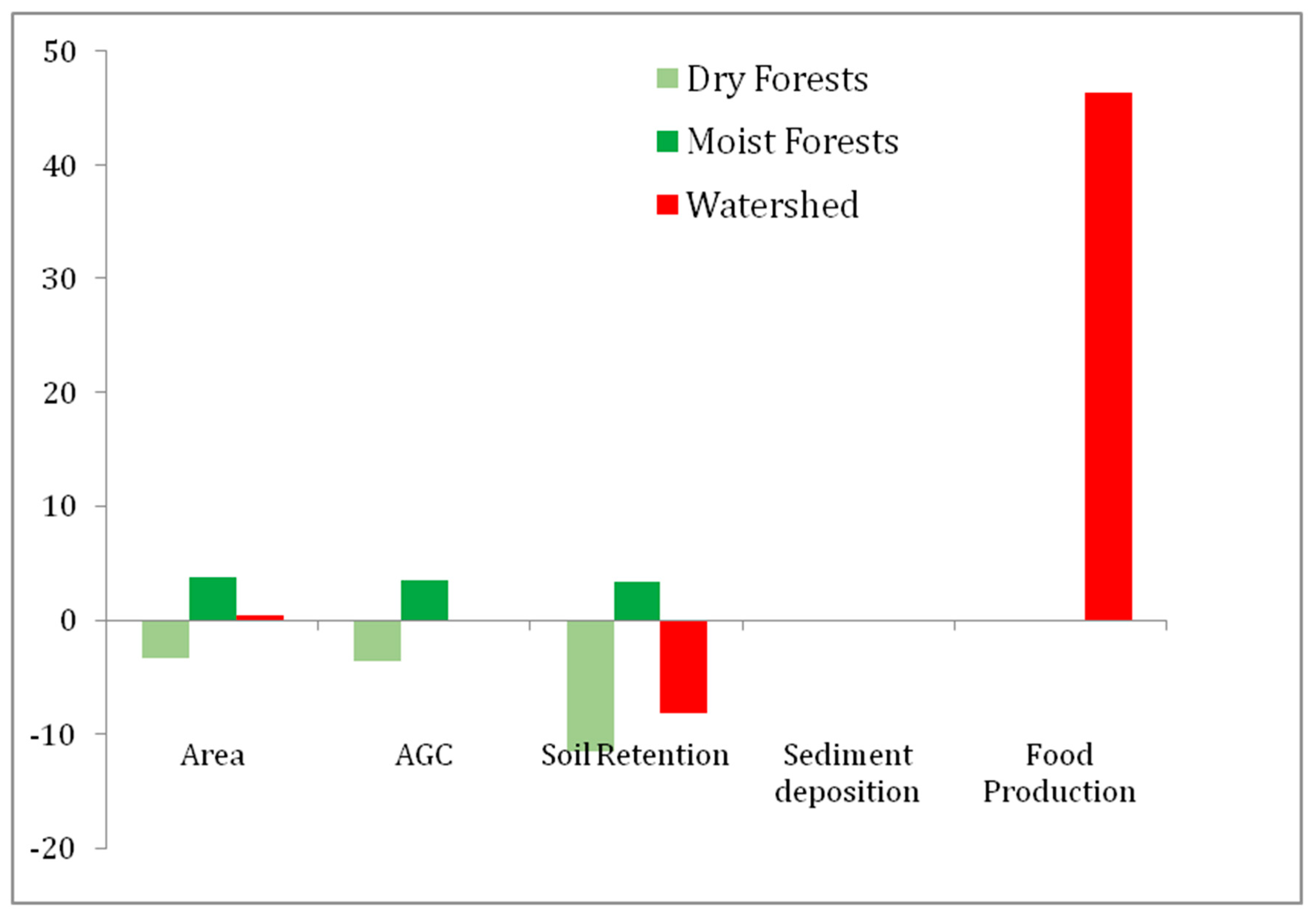
Based on our estimates, total above-ground carbon stored in forests was 20,048,414 Tn/ha in 1986 and 20,024,340 Tn/ha in 2006, implying a loss of 0.13% of the carbon stored in forests (Figure 2, Table 1, Nanni et al., 2015). The values of above-ground carbon estimated in this study are consistent with those reported in the literature for subtropical Yungas forests and dry Chaco forests [36,54]. Changes in carbon between 1986 and 2006 were overall determined by changes in forest area, but the estimated slight decrease in carbon stocks in the period is due to the fact that expanding Alnus acuminata forests store slightly less carbon than contracting dry forests (72.05 ± 6.25 Tn/ha and 97.83 ± 24.28 Tn/ha, respectively).
Total estimated soil erosion increased by 8.9%, from 2,576,610 Tn/year in 1986 to 2,805,945 Tn/year in 2006 (Figure 1d, Table 1). Mean soil loss values in 1986 were 19.39 Tn/ha in agricultural land, 4.74 Tn/ha in moist forests, 6.70 Tn/ha in grasslands, 4.00 Tn/ha in dry forests and 64.88 Tn/ha in bare soil areas. Modeled soil retention decreased in dry forest ecoregion (−12.6%) due to the expansion of agriculture at this altitude; but forest expansion over grasslands resulted in a 3.7% increase in modeled soil retention at higher altitudes (Figure 2). Thus, while forest redistribution in the region mitigated soil loss, modeled erosion prevailed over soil retention despite a net forest balance, due to the combined effect of increased slope length and the high erosion rates associated with some crops, particularly maize. In contrast to the modeling estimates of soil erosion, interannual variability in empirical data on sediment deposition rate at El Cadillal decreased, and was fully explained by changes in rainfall: estimates of rainfall-independent sediment deposition remained stable (R2 = 0.00, p = 0.93), with a zero-estimated change in rainfall-independent sediment deposition rate between 1986 and 2006.
Cattle heads increased from 31,029 to 45,407 between 1988 and 2009, representing an increase of at least +46.34% in the most important component of food production in the study area (Table 1, Figure 2). Modis-derived estimates of NPP remained stable between 2000 and 2010 (R2 = 0.03, p = 0.27); thus, increases in cattle density are likely coupled with intensive agriculture expansion, not to an overall increase in ecosystem productivity.

3.3. Estimated Changes in the Diversity of Birds and Medium-Large Mammals

The environmental gradient showed the effects in both birds and medium-large mammal richness and composition, but differences were more marked and statistically significant in birds (ANOVA R2 = 0.39; p = 0.002; ANOSIM global R2 = 0.79, p = 0.001 in birds versus ANOVA R2 = 0.13; p = 0.12; ANOSIM global R2 = 0.51; p = 0.001 in mammals) (Table 2). In both cases, richness levels were similar between dry forests and humid forests, while upper montane forests were about half as species-rich. The composition of bird and mammal communities significantly differed among the three forest types (Table 2), but again, the differences in bird communities were larger and reached higher levels of statistical significance. These more abrupt changes in species composition in bird communities suggest they could be comparatively more sensitive to the spatial segregation of forest losses and gains. In contrast, lower changes of medium-large mammal communities might indicate lower vulnerability to redistribution patterns.
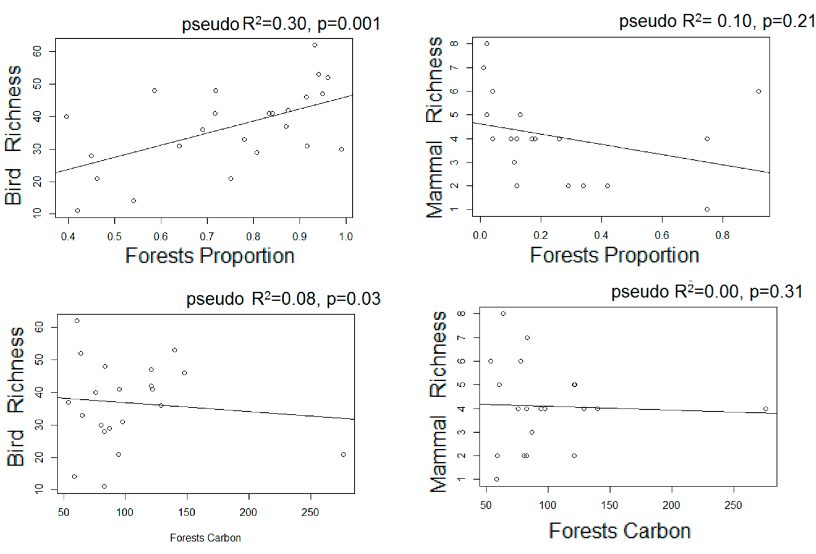
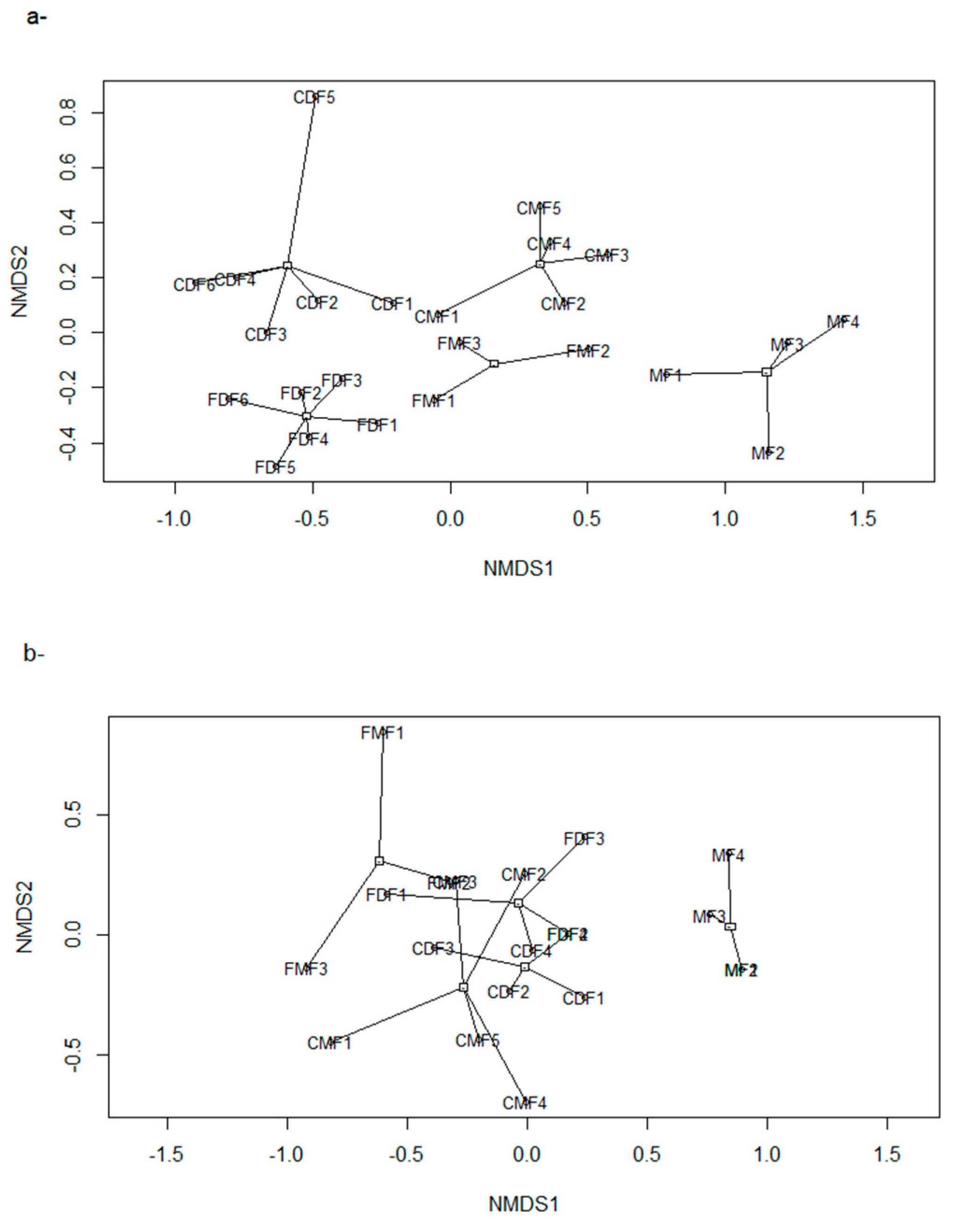
When assessing the influence on different land-use proxies over bird and mammal richness and composition through Poisson regressions and MDS ordinations, different responses emerged. Bird richness correlated positively and significantly with forest proportion in the surrounding landscape, but was not significantly associated with livestock frequency or to above-ground carbon (Figure 3). In the case of mammals, neither the proportion of forests, nor forest carbon, influenced their richness at statistically significant levels, but livestock frequency exhibited a negative and significant association (Figure 3). The ordination of the sampled sites in the multivariate space was consistent with the results of the linear models of both birds and medium-large mammals. The stress values were 0.9 and 0.13, respectively, for a two-dimensional ordination. In the case of birds, while the x axis clearly condensed the elevation gradient, the y axis segregated sites according to the proportion of forested area (i.e., fragmented vs. continuous forest sites) (Table 3, Figure 4). In the case of mammals, the influence of altitude was less marked; and forest proportion, above-ground carbon and livestock frequency associated significantly or marginally significantly with the y axis values. However, the ordination of the sites in the multivariate space was not clearly determined by any of the land-use proxies (Figure 4, Table 3).

4. Discussion

We combined quantitative detail of small regional-scale analyses with the assessment of the major global issue of balancing food production and nature conservation, and we explicitly accounted for the simultaneous influence of the two-major contemporary land cover change processes (deforestation and spontaneous forest regrowth), within a context of steep environmental heterogeneity due to topography. Mirroring the situation of other regions [5,6], in the study area the adjustment of agriculture towards more productive lands co-occurred with the recovery of forests in marginal areas at higher altitudes. Both processes (the expansion of agriculture and the expansion of forests) might have been amplified by rainfall increase, favoring both agriculture practices in the dry lowlands and Alnus acuminata recruitment in the highlands [7]. Therefore, the feedbacks between land-use change and climate change in the study area are worth exploring further.
Overall, this redistribution of forests and agricultural lands derived in higher land-use efficiency in the study area. A conservative estimate of 46% increase in food production (considering only increase in cattle density, but not per-individual productivity increases) did not result in equivalent losses in the ecosystem services and diversity of two main groups of vertebrates. While modeled soil erosion showed a moderate to low deterioration (<9%), carbon stocks and sediment discharge at the base of the watershed remained unchanged (Figure 2). In the case of birds and medium-large vertebrates, the distribution of forests seems to exhibit different consequences between the two groups.
The limitation for the expansion of mechanized agriculture, one of the main drivers of global forest loss [10] to flat slopes and well-drained soils is the key underlying factor shaping land cover redistribution; while geographic heterogeneity defines the ecological effects of such processes [9]. Usually, topographic gradients are associated with land-use intensity gradients: in marginal areas of high elevation and slope, subsistence economic activities (i.e., extensive cattle ranching, firewood extraction, and smallholders’ agriculture) dominate. Contemporary socioeconomic changes lead to rural-urban outmigration from marginal agriculture lands and to the development of off-farm economies, reducing land pressure in these areas. This, in turn, facilitates revegetation in certain scenarios [55,56], including this study area [7,23].
Environmental gradients control agriculture suitability and both vegetation and fauna patterns, generating complex feedbacks. Our study highlights that the geographic segregation of deforestation and reforestation especially affects communities that are highly associated to certain forest types, such as birds in the study area. For this group, montane forest recovery might benefit particular assemblages, but will not reverse threats for distinctive dry forests communities, which become affected by lowland deforestation. Medium to large mammals, in contrast, exhibited lower changes in their composition, probably due to their broader niche requirements coupled with the relatively small area of the study region. However, they seemed to be less tolerant to human activities within forests. In the study area and the period analyzed, certain types of livestock (i.e., sheep, goats) decreased, but cattle increased. Although agriculture expanded mostly in the form of forage crops, cattle also forage in forests and other natural habitats, likely leading to declining habitat suitability for medium-large mammals due to increasing livestock density. Our study did not assess the mechanisms through which extensive cattle ranching affects mammal assemblages, but they likely involve a combination of competition for space and resources (especially with native ungulates; e.g., Mazama gouazoubira, [57]), such as hunting to protect livestock from predation by large carnivores [58], or negative interactions with human populations and other domestic animals (e.g., dogs) in natural ecosystems associated with livestock management.
To further assess and validate the responses of diversity found in this study, certain caveats of our biodiversity sampling design should be taken into account and overcome: the high heterogeneity of the study area requires greater sampling effort to better capture animal community composition. Especially in the case of medium-large mammals sampling, the lack of differences in species composition among forest types could be due to a low number of samples, and/or to biases associated to the method, since the probability of detection through camera-traps varies among mammal species [59]. We emphasize, however, that more insightful than the specific responses of these two vertebrate groups to the land-use proxies here analyzed, is the fact that different biological groups (birds, medium-large mammals) and dimensions of diversity (species richness, species composition) are distinctively influenced by the interaction between land-use and environmental heterogeneity. Although key for conservation planning, these varying responses have not been the target of land-sparing/land-sharing analyses, which assume a common species pool and a homogenous physical environment [9]. Furthermore, the very nature of the environmental control over the suitability for mechanized agriculture is radically different: while species abundance and community composition tend to respond to gradients in temperature and moisture in a gradual fashion, mechanized agriculture suitability is essentially stepwise, with a hard limit between very suitable (assuming sufficient humidity and temperature) below ca. 10% of steep slope, and nearly null suitability above this threshold, disregarding climate and soil conditions. In regions undergoing agriculture adjustment towards more productive soils, this threshold appears to generate a human-mediated ecological “switch” (sensu Wilson and King, [60]) between land-use intensification and disintensification zones, which is a key feature of the land redistribution pattern observed here [61].
For the ecosystem services assessed in this study, forest recovery at higher altitudes mitigated losses derived from deforestation in the lowlands, but to different extents. Changes in above-ground carbon storage were closely related to changes in forest area, since emerging montane forests harbored similar quantities of above-ground carbon than disappearing dry forests at lower altitudes (although slightly lower due to generally lower wood density of the dominant trees). The redistribution of carbon stocks across forest types has also been detected at larger scales [62] and within forests [17]. This pattern highlights the need to additionally assess both below-ground carbon storage among forest types, and for the influence of processes that occur beyond changes in forested area (i.e., degradation, forest regrowth). Our modeling exercise based on the RUSLE equation suggests a ca. 9% increase in soil erosion, resulting mostly from the large field sizes of the deforested areas, and a moderate level of conservation practices in the agriculture fields. The semiarid conditions of the study area, coupled with a long history of soil degradation due to overgrazing and wood extraction, have probably enhanced soil loss at low altitudes, and derived in a relatively high erosion risk for the region [63]. The expansion of forests in areas of high slope and precipitation contributed to soil retention at these sectors, and mitigated total soil loss in the study period. Although this modeling exercise provides insights on how erosion may respond to changes in land cover patterns other than net forest cover, their net output should be considered with caution, due to the limitations to correctly parameterize the coefficients of different land cover types (C). Contrastingly, the empirical data showed a decrease in sediment deposition at El Cadillal in the past decades [40]. Statistically, this decrease is fully “explained” by the decrease in rainfall during the period, implying that the rainfall-independent sedimentation rate during the study period remained unchanged. The observed stability in MODIS-derived NPP estimates and the increase in cattle production in the area indicates that, at least during the study period, soil erosion has not resulted in a fertility loss that cannot be managed by standard fertilization and management practices. In summary, the most economically tangible components of non-provisioning environmental services (soil fertility, reservoir conservation for irrigation, energy and water consumption) did not deteriorate significantly despite the major increase in cattle production in the area.
While we chose our study area to be representative of the main land-use trends in Latin America [5,64], the limitations of a single case study should not be overlooked. Relative balances of gains and losses could change in analyses at different scales or with different natural and managed ecosystems involved. We did not assess changes in important biodiversity groups (e.g., plants, insects) or in other relevant environmental services, such as recreation potential (likely increasing due to better conservation of mountain landscapes) or crop pollination (likely decreasing due to expanding field sizes in the lowlands). Additionally, agriculture intensification through rises in cattle implies increases in greenhouse gas emissions in the form of CH4 from livestock enteric fermentation and CH4 and N2O from manure management [65], although yield improvement has significantly avoided emissions in the last decades [66]. These trade-offs, as well as other costs of agriculture intensification, such as chemical contamination of water and the loss of agrobiodiversity and traditional landscapes [67] should be assessed. Additionally, in fertile regions with limited biophysical or policy constraints for agriculture expansion, like many areas of South America, increasing yields may not result in land spared for nature [68]. Mountain forests recovery in these regions might not compensate for forest losses due to an imbalance in terms of area; while regions with the highest proportion of unsuitable land for agriculture, like the Andes, Central America, and Caribbean, can provide spontaneous opportunities for conservation [5,6].

5. Conclusions

In spite of the relatively small size of our study region, we included two scales of analysis, at which different responses emerged. Within ecoregions (strongly differing in agriculture suitability), food production exhibited a clear trade-off with forest area, above-ground carbon stocks, soil retention, and biodiversity, as largely reported in the literature [8,69]. However, at the whole watershed scale, most of these trade-offs partially or totally disappeared as complex patterns and interactions between landscape and land-use heterogeneity emerged: forest gains at higher altitudes compensated for lowland forest losses, giving a place to forest redistribution processes rather than to the classical forest transition pathway (Table 1, Figure 2). Such redistribution of forests compensated carbon stock losses in dry forests and mitigated soil losses derived from agriculture expansion, with large increases in food production and no effects on watershed-scale sediment yield. The responses of birds and medium to large mammals to such processes reflect the need of assessing the responses of target groups to environmental heterogeneity for conservation planning.
Global demand for land products resulting from population growth and dietary changes associated with increasing population and income [70] will continue threatening natural habitats and their biodiversity, especially in fertile regions; while land-use pressure will likely continue to decrease in areas with low quality for modern agriculture [5,64]. Under this scenario, land-use efficiency might increase (i.e., increasing yields might indeed spare land for nature) if policy focuses in taking advantages of land use disintensification for ecological restoration, and promotes sound landscape-scale management practices, including the preservation of natural ecosystems in areas suitable for agriculture expansion.

Acknowledgments

We thank N. Ignacio Gasparri at the Instituto de Ecología Regional, for his assistance with satellite and GIS analyses, and all the people who helped the first author during the field work. Funding: This research was funded by Consejo Nacional de Investigaciones Científicas y Técnicas (CONICET, postdoctoral scholarship) and the 2nd Rufford Small Grant for Nature Conservation to the ASN project “Consequences of ecological and land-use heterogeneity over multiple ecosystem services provision and nature conservation in a subtropical watershed of NW Argentina”. Additional funds were provided by grant PICT 2012–1565, from FONCYT, Argentina to HRG.

Author Contributions

A.S.N. and H.R.G. designed the study. A.S.N. performed the field sampling, GIS analyses and analyzed the data. A.S.N. and H.R.G. wrote the paper.

Conflicts of Interest

The authors declare no conflict of interest.

References

  1. Tilman, D.; Balzer, C.; Hill, J.; Befort, B.L. Global food demand and the sustainable intensification of agriculture. Proc. Natl. Acad. Sci. USA 2011, 108, 20260–20264. [Google Scholar] [CrossRef] [PubMed]
  2. Verburg, P.H.; Crossman, N.; Ellis, E.C.; Heinimann, A.; Hostert, P.; Mertz, O.; Nagendra, H.; Sikor, T.; Erb, K.; Golubiewski, N.; et al. Land system science and sustainable development of the earth system: A global land project perspective. Anthropocene 2015, 12, 29–41. [Google Scholar] [CrossRef] [Green Version]
  3. Fahrig, L. Effects of habitat fragmentation on biodiversity. Annu. Rev. Ecol. Evol. Syst. 2003, 34, 487–515. [Google Scholar] [CrossRef]
  4. Mather, A.S.; Needle, C.L. The forest transition: A theoretical basis. Area 1998, 30, 117–124. [Google Scholar] [CrossRef]
  5. Aide, T.M.; Clark, M.L.; Grau, H.R.; López-Carr, D.; Levy, M.A.; Redo, D.; Bonilla-Moheno, M.; Riner, G.; Andrade-Núñez, M.J.; Muñiz, M. Deforestation and reforestation of Latin America and the Caribbean (2001–2010). Biotropica 2013, 45, 262–271. [Google Scholar] [CrossRef]
  6. Redo, D.J.; Grau, H.R.; Aide, T.M.; Clark, M.L. Asymmetric forest transition driven by the interaction of socioeconomic development and environmental heterogeneity in Central America. Proc. Natl. Acad. Sci. USA 2012, 109, 8839–8844. [Google Scholar] [CrossRef] [PubMed]
  7. Nanni, A.S.; Grau, H.R. Agricultural adjustment, population dynamics and forests redistribution in a subtropical watershed of NW Argentina. Reg. Environ. Chang. 2014, 14, 1641–1649. [Google Scholar] [CrossRef]
  8. Phalan, B.; Onial, M.; Balmford, A.; Green, R.E. Reconciling food production and biodiversity conservation: Land sharing and land sparing compared. Science 2011, 333, 1289–1291. [Google Scholar] [CrossRef] [PubMed]
  9. Grau, R.; Kuemmerle, T.; Macchi, L. Beyond ‘land sparing versus land sharing’: Environmental heterogeneity, globalization and the balance between agricultural production and nature conservation. Curr. Opin. Environ. Sustain. 2013, 5, 477–483. [Google Scholar] [CrossRef]
  10. Geist, H.J.; Lambin, E.F. What drives tropical deforestation. LUCC Rep. Ser. 2001, 4, 116. [Google Scholar]
  11. Niamir-Fuller, M.; Kerven, C.; Reid, R.; Milner-Gulland, E. Co-existence of wildlife and pastoralism on extensive rangelands: Competition or compatibility? Pastor. Res. Policy Pract. 2012, 2, 1. [Google Scholar] [CrossRef]
  12. Berry, P.M.; Rounsevell, M.D.A.; Harrison, P.A.; Audsley, E. Assessing the vulnerability of agricultural land use and species to climate change and the role of policy in facilitating adaptation. Environ. Sci. Policy 2006, 9, 189–204. [Google Scholar] [CrossRef]
  13. Cumming, G.S. Spatial resilience: Integrating landscape ecology, resilience, and sustainability. Landsc. Ecol. 2011, 26, 899–909. [Google Scholar] [CrossRef]
  14. Pianka, E.R. Latitudinal gradients in species diversity: A review of concepts. Am. Nat. 1966, 100, 33–46. [Google Scholar] [CrossRef]
  15. Bruun, T.B.; De Neergaard, A.; Lawrence, D.; Ziegler, A.D. Environmental consequences of the demise in swidden cultivation in Southeast Asia: Carbon storage and soil quality. Hum. Ecol. 2009, 37, 375–388. [Google Scholar] [CrossRef]
  16. Powers, J.S.; Corre, M.D.; Twine, T.E.; Veldkamp, E. Geographic bias of field observations of soil carbon stocks with tropical land-use changes precludes spatial extrapolation. Proc. Natl. Acad. Sci. USA 2011, 108, 6318–6322. [Google Scholar] [CrossRef] [PubMed]
  17. Nanni, A.S.; Gasparri, N.I.; Grau, H.R. Redistribution of forest biomass in a heterogeneous environment of subtropical Andes undergoing agriculture adjustment. Appl. Geogr. 2015, 62, 107–114. [Google Scholar] [CrossRef]
  18. Gibbs, H.K.; Brown, S.; Niles, J.O.; Foley, J.A. Monitoring and estimating tropical forest carbon stocks: Making REDD a reality. Environ. Res. Lett. 2007, 2, 045023. [Google Scholar] [CrossRef]
  19. Farley, K.A.; Jobbágy, E.G.; Jackson, R.B. Effects of afforestation on water yield: A global synthesis with implications for policy. Glob. Chang. Biol. 2005, 11, 1565–1576. [Google Scholar] [CrossRef]
  20. Turner, M.G.; Donato, D.C.; Romme, W.H. Consequences of spatial heterogeneity for ecosystem services in changing forest landscapes: Priorities for future research. Landsc. Ecol. 2013, 28, 1081–1097. [Google Scholar] [CrossRef]
  21. Garrido, H.B. Población y tierra en la cuenca de Trancas provincia de Tucumán (República Argentina). Cuad. Desarro. Rural 2005, 54, 31–60. [Google Scholar]
  22. Minetti, J.L.; Lamelas, C.M. Respuesta regional de la soja en Tucumán a la variabilidad climática. Rev. Ind. Agríc. Tucuman 1997, 72, 63–68. [Google Scholar]
  23. Aráoz, E.; Grau, H.R. Fire-mediated forest encroachment in response to climatic and land-use change in subtropical Andean treelines. Ecosystems 2010, 13, 992–1005. [Google Scholar] [CrossRef]
  24. INDEC Argentina. Censo Nacional Agropecuario 1988; Instituto Nacional de Estadísticas y Censos de la República Argentina: Buenos Aires, Argentina, 1988. [Google Scholar]
  25. INDEC Argentina. Censo Nacional Agropecuario 2002; Instituto Nacional de Estadísticas y Censos de la República Argentina: Buenos Aires, Argentina, 2002. [Google Scholar]
  26. Observatorio Ganadero. Caracterización regional: Noroeste argentino. In Observatorio de la Cadena de la Carne Bovina de Argentina. Argent. Informe N°3; Observatorio Ganadero: Buenos Aires, Argentina, 2013; p. 14. [Google Scholar]
  27. INDEC Argentina. Censo Nacional de Población, Hogares y Vivienda; Instituto Nacional de Estadísticas y Censos de la República Argentina: Buenos Aires, Argentina, 2010. [Google Scholar]
  28. Breiman, L. Random forests. Mach. Learn. 2001, 45, 5–32. [Google Scholar] [CrossRef]
  29. Liaw, A.; Wiener, M. Classification and regression by random Forest. R News 2002, 2, 18–22. [Google Scholar]
  30. Pebesma, E.J.; Bivand, R.S. Classes and methods for spatial data in R. R News 2005, 5, 9–13. [Google Scholar]
  31. Cabrera, A.L. Enciclopedia Argentina de agricultura y jardinería, Tomo II, Fascículo 1: regiones fitogeográficas Argentinas; ACME: Buenos Aires, Argentina, 1994; p. 85. [Google Scholar]
  32. Antuña, J.C.; Rossanigo, C.; Arano, A.; Caldera, J. Análisis de la Actividad Ganadera Bovina de Carne por Estratos de Productores y Composición del Stock. Años 2008 y 2009. Provincia de Tucumán. Red de Información Agropecuaria Nacional Ganadero–Instituto Nacional de Tecnología Agropecuaria, Buenos Aires, Argentina. Available online: http://www.inta.gov.ar/info/rian/2010/Pais_por_provincias.pdf (accessed on 10 August 2017).
  33. Steinfeld, H.; Mäki-Hokkonen, J. A classification of livestock production systems. World Anim. Rev. 1995, 83–94. Available online: http://www.fao.org/ag/aga/agap/frg/FEEDback/War/V8180b/v8180b0y.htm#TopOfPage (accessed on 17 August 2017).
  34. Pimentel, D.; Burgess, M. Soil erosion threatens food production. Agriculture 2013, 3, 443–463. [Google Scholar] [CrossRef]
  35. Running, S.W.; Justice, C.O.; Salomonson, V.; Hall, D.; Barker, J.; Kaufmann, Y.J.; Strahler, A.H.; Huete, A.R.; Muller, J.P.; Vanderbilt, V.; et al. Terrestrial remote sensing science and algorithms planned for EOS/MODIS. Int. J. Remote Sens. 1994, 15, 3587–3620. [Google Scholar] [CrossRef]
  36. Gasparri, N.I.; Baldi, G. Regional patterns and controls of biomass in semiarid woodlands: Lessons from the Northern Argentina Dry Chaco. Reg. Environ. Chang. 2013, 13, 1131–1144. [Google Scholar] [CrossRef]
  37. Secretaria de Ambiente y Desarrollo Sustentable (SAyDS). Bases para una Agenda Ambiental Nacional. Politica Ambiental Sostenible para El Crecimiento y La Equidad. 2004. Available online: http://publicaciones.ops.org.ar/publicaciones/saludAmbiental/RM/cdsMCS/05/pub_msan/base_agenda.pdf (accessed on 17 August 2017).
  38. Brown, S.; Lugo, A.E. Biomass of tropical forests: A new estimate based on forest volumes. Science 1984, 223, 1290–1293. [Google Scholar] [CrossRef] [PubMed]
  39. Chave, J.; Andalo, C.; Brown, S.; Cairns, M.A.; Chambers, J.Q.; Eamus, D.; Fölster, H.; Fromard, F.; Higuchi, N.; Kira, T.; et al. Tree allometry and improved estimation of carbon stocks and balance in tropical forests. Oecologia 2005, 145, 87–99. [Google Scholar] [CrossRef] [PubMed]
  40. Huespe, J.; Suppo, H.; Tabernig, D. Estudios de Batimetría 2009. Embalse El Cadillal. INCOCIV S.R.L. Consultora. 2009, p. 53. Available online: https://www.google.com.hk/url?sa=t&rct=j&q=&esrc=s&source=web&cd=1&ved=0ahUKEwjrio3O1t3VAhVQhrwKHRHRCAkQFgglMAA&url=http%3A%2F%2Fhidrotuc.homelinux.net%2Fcomprasweb%2Ftucuman%2Fadjuntos%2FRM%25203697%2FEl%2520Cadillal%2F2009%2520Cadillal%2FInforme%2520El%2520Cadillal%2520rev3.pdf&usg=AFQjCNFB-0m4cZOn-X62g_PRel24osxMoA (accessed on 17 August 2017).
  41. Renard, K.G.; Freimund, J.R. Using monthly precipitation data to estimate the R-factor in the revised USLE. J. Hydrol. 1994, 157, 287–306. [Google Scholar] [CrossRef]
  42. Millward, A.A.; Mersey, J.E. Adapting the RUSLE to model soil erosion potential in a mountainous tropical watershed. Catena 1999, 38, 109–129. [Google Scholar] [CrossRef]
  43. Volante, J.N.; Noe, Y.E.; Gonzalez, A.C. Isohietas Anuales del Noroeste Argentino. Instituto Nacional de Tecnología Agropecuaria, Artículo de Divulgación. 2012. Available online: http://inta.gob.ar/documentos/isohietas-anuales-del-noroeste-argentino-0 (accessed on 17 August 2017).
  44. Atlas de Suelos de la República Argentina. Available online: https://searchworks.stanford.edu/view/669553 (accessed on 17 August 2017).
  45. Wischmeier, W.H.; Smith, D.D. Predicting Rainfall Erosion Losses—A Guide to Conservation Planning; Science and Education Administration, U.S. Department of Agriculture: Washington, DC, USA, 1978.
  46. Jarvis, A.; Reuter, H.I.; Nelson, A. Hole-filled SRTM for the globe Version 4. The CGIAR-CSI SRTM 90 m Database. 2008. Available online: http://srtm.csi.cgiar.org (accessed on 12 August 2012).
  47. Mitasova, H.; Hofierka, J.; Zlocha, M.; Iverson, L.R. Modelling topographic potential for erosion and deposition using GIS. Int. J. Geogr. Inf. Syst. 1996, 10, 629–641. [Google Scholar] [CrossRef]
  48. Sayago, J.M. Aspectos Metodológicos del Inventario de la Erosión Hidrica Mediante Technicas de Perceptión Remota en la Región Sub-Tropical del Noroeste Argentino; International Institute for Aerospace Survey and Earth Sciences: Enschede, The Netherlands, 1985. [Google Scholar]
  49. Mármol, L.A. Introducción al Manejo de Cuencas Hidrográficas y Corrección de Torrentes, 1st ed.; Universidad Nacional de Salta: Salta, Argentina, 2006; p. 287. [Google Scholar]
  50. Legendre, P.; Legendre, L. Numerical ecology: Second English edition. In Developments in Environmental Modelling; Elsevier Science: Amsterdam, The Netherlands, 1998; Volume 20. [Google Scholar]
  51. Ralph, C.J.; Geupel, G.R.; Pyle, P.; Martin, T.E.; DeSante, D.F.; Milá, B. Manual de Métodos de Campo Para el Monitoreo de Aves Terrestres; U.S. Department of Agriculture: Albany, KY, USA, 1996; p. 46.
  52. Oksanen, J.; Blanchet, F.G.; Kindt, R.; Legendre, P.; Minchin, P.R.; O’hara, R.B.; Simpson, G.L.; Solymos, P.; Stevens, M.H.H.; Wagner, H.; et al. Package ‘vegan’. Community Ecol. Package 2013, 2. Available online: cran.ism.ac.jp/web/packages/vegan/vegan.pdf (accessed on 17 August 2017).
  53. Rempel, R.S.; Kaukinen, D.; Carr, A.P. Patch Analyst and Patch Grid; Ontario Ministry of Natural Resources, Centre for Northern Forest Ecosystem Research: Thunder Bay, ON, Canada, 2012.
  54. Grau, H.R.; Paolini, L.; Malizia, A.; Carilla, J. Distribución, estructura y dinámica de los bosques de la Sierra de San Javier. In Ecologıa de una Interfase Natural-Urbana: La Sierra de San Javier y el Gran San Miguel de Tucumán; EDUNT: Tucumán, Argentina, 2010; pp. 33–48. [Google Scholar]
  55. Rudel, T.K.; Bates, D.; Machinguiashi, R. A tropical forest transition? Agricultural change, out-migration, and secondary forests in the Ecuadorian Amazon. Ann. Assoc. Am. Geogr. 2002, 92, 87–102. [Google Scholar] [CrossRef]
  56. Lambin, E.F.; Meyfroidt, P. Land use transitions: Socio-ecological feedback versus socio-economic change. Land Use Policy 2010, 27, 108–118. [Google Scholar] [CrossRef]
  57. Nanni, A.S. Dissimilar responses of the Gray brocket deer (Mazama gouazoubira), Crab-eating fox (Cerdocyon thous) and Pampas fox (Lycalopex gymnocercus) to livestock frequency in subtropical forests of NW Argentina. Mamm. Biol.-Z. Säugetierkunde 2015, 80, 260–264. [Google Scholar] [CrossRef]
  58. Loveridge, A.J.; Hemson, G.; Davidson, Z.; Macdonald, D.W. African lions on the edge: Reserve boundaries as ‘attractive sinks’. In Biology and Conservation of Wild Felids; Macdonald, D.W., Loveridge, A.J., Eds.; Oxford University Press: New York, NY, USA, 2010; pp. 283–304. [Google Scholar]
  59. Tobler, M.W.; Carrillo-Percastegui, S.E.; Leite Pitman, R.; Mares, R.; Powell, G. An evaluation of camera traps for inventorying large-and medium-sized terrestrial rainforest mammals. Anim. Conserv. 2008, 11, 169–178. [Google Scholar] [CrossRef]
  60. Wilson, J.B.; King, W.M. Human-mediated vegetation switches as processes in landscape ecology. Landsc. Ecol. 1995, 10, 191–196. [Google Scholar] [CrossRef]
  61. Grau, H.R. Equilibrios alternativos mediados por decisiones humanas: Controles de la estabilidad y la eficiencia del uso y cobertura del territorio en América Latina. In Naturaleza y Sociedad. Perspectivas Socioecológicas sobre Cambios Globales en América Latina; Postigo, J.C., Young, K.R., Eds.; Instituto de Estudios Peruanos: Lima, Peru, 2016; pp. 171–192. [Google Scholar]
  62. Liu, Y.Y.; Van Dijk, A.I.; De Jeu, R.A.; Canadell, J.G.; McCabe, M.F.; Evans, J.P.; Wang, G. Recent reversal in loss of global terrestrial biomass. Nat. Clim. Chang. 2015, 5, 470–474. [Google Scholar] [CrossRef]
  63. Michelena, R.G.; Irurtia, C.B. Physical conservationist diagnosis and degradation processes in the Choromoro river basin, Tucuman, Argentina [poster]. In Proceedings of the Reunion Internacional Sobre Procesos de Erosion en Tierras Altas Pendientes: Evaluacion y Modelaje, Merida (Venezuela), Mexico, 16–20 May 1993. [Google Scholar]
  64. Grau, H.R.; Aide, T.M. Globalization and land use transitions in Latin America. Ecol. Soc. 2008, 13, 16. [Google Scholar] [CrossRef]
  65. Wise, M.; Calvin, K.; Thomson, A.; Clarke, L.; Bond-Lamberty, B.; Sands, R.; Smith, S.J.; Janetos, A.; Edmonds, J. Implications of limiting CO2 concentrations for land use and energy. Science 2009, 324, 1183–1186. [Google Scholar] [CrossRef] [PubMed]
  66. Burney, J.A.; Davis, S.J.; Lobell, D.B. Greenhouse gas mitigation by agricultural intensification. Proc. Natl. Acad. Sci. USA 2010, 107, 12052–12057. [Google Scholar] [CrossRef] [PubMed]
  67. Fischer, J.; Brosi, B.; Daily, G.C.; Ehrlich, P.R.; Goldman, R.; Goldstein, J.; Lindenmayer, D.B.; Manning, A.D.; Mooney, H.A.; Pejchar, L.; et al. Should agricultural policies encourage land sparing or wildlife-friendly farming? Front. Ecol. Environ. 2008, 6, 380–385. [Google Scholar] [CrossRef]
  68. Ceddia, M.G.; Gunter, U.; Corriveau-Bourque, A. Land tenure and agricultural expansion in Latin America: The role of Indigenous Peoples’ and local communities’ forest rights. Glob. Environ. Chang. 2015, 35, 316–322. [Google Scholar] [CrossRef]
  69. Foley, J.A.; DeFries, R.; Asner, G.P.; Barford, C.; Bonan, G.; Carpenter, S.R.; Chapin, F.S.; Coe, M.T.; Daily, G.C.; Gibbs, H.K.; et al. Global consequences of land use. Science 2005, 309, 570–574. [Google Scholar] [CrossRef] [PubMed]
  70. Kastner, T.; Rivas, M.J.I.; Koch, W.; Nonhebel, S. Global changes in diets and the consequences for land requirements for food. Proc. Natl. Acad. Sci. USA 2012, 109, 6868–6872. [Google Scholar] [CrossRef] [PubMed]
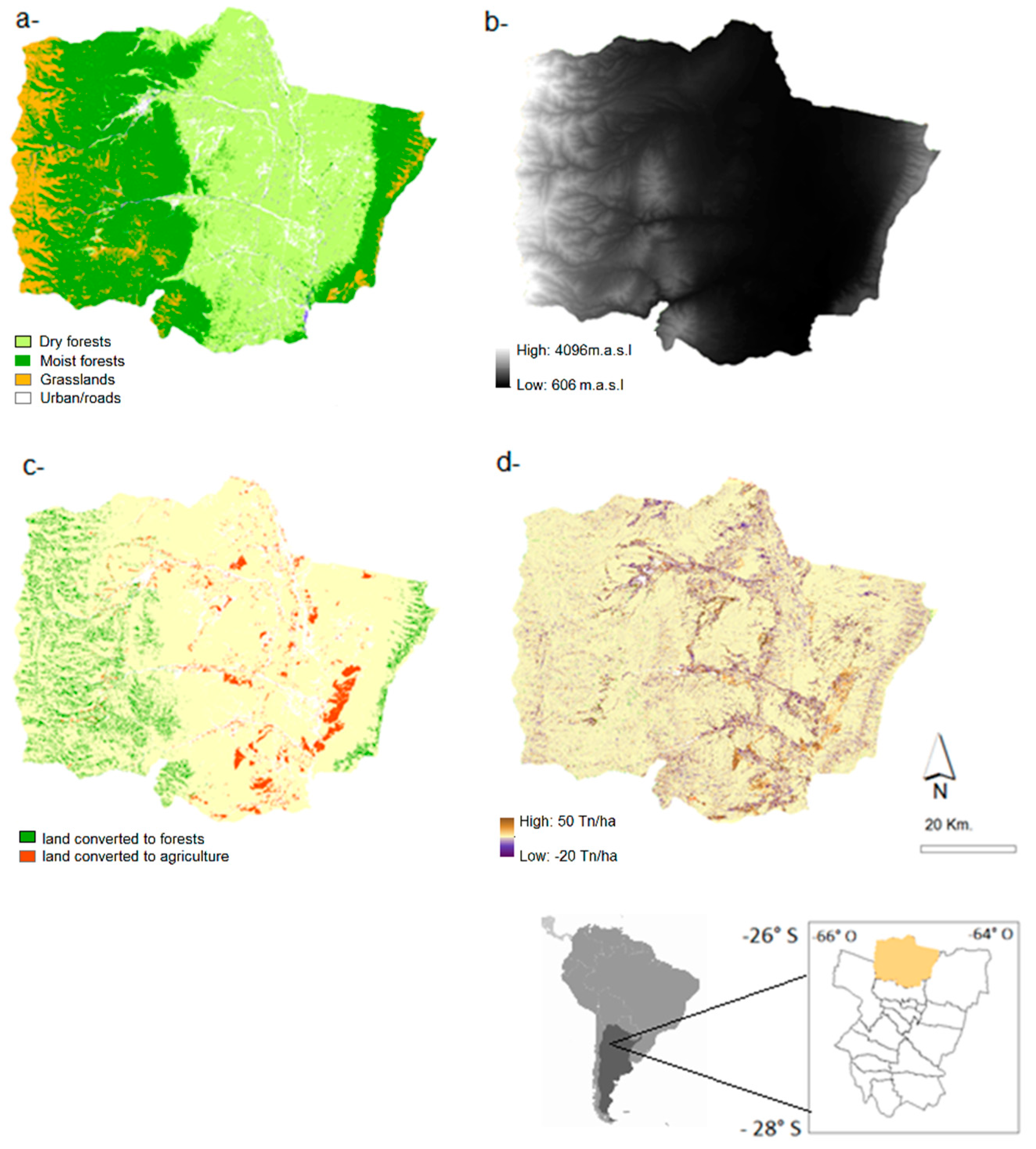
Figure 1. Study area, including (a) ecoregions; (b) digital elevation model; (c) land cover change (based on Nanni and Grau, 2014); and (d) soil retention change between 1986 and 2006. Bottom right: limits of Argentina within South America and of Trancas Department within Tucumán province.
Forests 08 00303 g001
Figure 2. Percentage change in forest area (area; as a proportion of total forest area), above-ground carbon (AGC), soil retention, sediment deposition, and food production between 1986 and 2006; with and without discriminating among forest types (watershed, red bar; dry and moist forests, light green and dark green bars, respectively).
Forests 08 00303 g002
Figure 3. Scatterplots showing associations between bird and mammal richness and land-use proxies.
Forests 08 00303 g003aForests 08 00303 g003b
Figure 4. Non-metric multidimensional scaling ordinations of bird (a) and medium-large mammal (b) sampling units based on species abundance. Centroids of the sampling units belonging to continuous dry forests (CDF), fragmented dry forests (FDF), continuous moist forests (CMF), fragmented moist forests (FMF), and upper montane forests (MF) are represented by a square.
Forests 08 00303 g004
Table 1. Changes in forested area (as the proportion of the area of each forest type), ecosystem services provision, and habitat suitability for birds and medium-large mammals between 1986 and 2006, including total and percentage change. Food Prod. = food production; AGC = above-ground carbon; and Sed. Dep = Sediment Deposition.
YearDry F (ha)Moist F (ha)Total F (ha)Food Prod. (N° Cattle Heads)AGC (Tn/ha)Soil Retention (Tn/ha)Sed. Dep (Hm3)
1986103,345117,580220,92531,02920,048,413−2,576,61077.71
200695,989125,684214,65145,40720,022,435−2,805,94377.91
Change−7356810474814,378−25,979−229,333−0.19
% Change−7.666.40.3446.34−0.13−8.90−0.2
Table 2. p values of Tukey test (left) and R2 values of ANOSIM (right) for birds and mammals between forest treatments (DF = dry forests; MF = moist forests; MonF = montane forests). In the ANOSIM, asterisks represent significance at the 0.05 (*) and 0.01 (**) levels, respectively.
Bird RichnessMammal RichnessBird SimilarityMammal Similarity
DF-MF0.760.100.670 **0.35 *
DF-MonF0.0010.820.99 **0.70 *
MF-MonF0.0090.230.90 **0.62 *
Table 3. Pearson correlations among axes 1 and 2 scores and habitat suitability proxies (F Prop = Forest proportion; AGC = above-ground-carbon; Livestock F = livestock frequency) for birds (left) and medium-large mammals (right). Asterisks represent significance at the 0.1 (*), 0.05 (**), and 0.01 (***) levels (due to incomplete sampling the correlation between livestock frequency and the ordination axes was not assessed for birds).
HS ProxiesNMDS1NMDS2R2NMDS1NMDS2R2
Altitude0.99−0.090.86 ***0.99−0.120.25 *
F Prop−0.990.990.50 ***0.730.670.35 **
AGC0.970.230.02−0.920.370.29 *
Livestock F---0.480.870.30 **