Article

Advancing Integrated Fire Management and Closer-to-Nature Forest Management: A Holistic Approach to Wildfire Risk Reduction and Ecosystem Resilience in Quinta da França, Portugal

1
MARETEC—Marine, Environment & Technology Center/LARSyS—Laboratory of Robotics and Engineering Systems, Instituto Superior Técnico, Universidade de Lisboa, Av. Rovisco Pais 1, 1049-001 Lisbon, Portugal
2
Terraprima—Serviços Ambientais, Sociedade Unipessoal, Lda., 2135-199 Samora Correia, Portugal
3
Center for Security Studies, Emergency Management and Civil Protection Sector, 4 Kanellopoulou Str., GR-10177 Athens, Greece
4
Venaka Treleaf, Fahrlander Weg 81, 13591 Berlin, Germany
5
EDP CNETCentre for New Energy Technologies, Rua Particular à Rua Cidade de Goa, 2, 2685-038 Sacavém, Portugal
*
Author to whom correspondence should be addressed.
Forests 2025, 16(8), 1306; https://doi.org/10.3390/f16081306
Submission received: 16 May 2025 / Revised: 14 July 2025 / Accepted: 23 July 2025 / Published: 11 August 2025
(This article belongs to the Section Forest Ecology and Management)

Abstract

The escalating threat of climate-driven wildfires, land abandonment, wildland–urban interface expansion, and inadequate forest management poses an existential challenge to Mediterranean oak ecosystems, for which traditional fire suppression has proven insufficient. This paper presents a combination of integrated fire management (IFM) and closer-to-nature forest management (CTNFM) in a representative mixed Pyrenean oak (Quercus pyrenaica) forest at Quinta da França (QF), in Portugal. It is structured around three main objectives designed to evaluate this pioneer integrated approach: (1) to describe the integration of IFM and CTNFM within an agro-silvo-pastoral landscape; (2) to qualitatively assess its ecological, operational, and socio-economic outcomes; and (3) to quantitatively evaluate the effectiveness of two key nature-based solutions (NbSs), that is, prescribed burning and planned grazing, in reducing wildfire risk and enhancing forest resilience and biodiversity. By strategically combining proactive fuel reduction with biodiversity-oriented silviculture, the QF case provides a replicable model for managing analogous Mediterranean forested areas facing similar risks. This integrated approach supports forest multifunctionality, advancing both prevention and adaptation goals, and directly contributes to the ambitious targets set by the European Union’s New Forest and Biodiversity Strategies for 2030, marking a significant step towards a more sustainable and fire-resilient future for such Mediterranean landscapes.

1. Introduction

From 2011 to 2020, the world experienced a concerning increase in global temperatures by approximately 1.1 °C compared to pre-industrial levels (1850–1900). This trend is expected to continue, with projections indicating a likely exceedance of the 1.5 °C threshold between 2021 and 2040, even under optimistic low-emission scenarios [1]. While this global pattern provides an important context, its impacts are particularly acute in the Mediterranean region, where oak-dominated ecosystems are facing intensified wildfire regimes due to drier conditions and extended fire seasons [2]. Forest ecosystems are increasingly vulnerable to the interplay of warmer temperatures, land abandonment, and extended growing seasons. These changes have created conditions favourable to an increase in extreme wildfire events, as reported by recent studies across fire-prone Mediterranean and global landscapes [3,4,5,6]. This phenomenon is not only driven by climate but also exacerbated by increased human presence in fire-prone areas, especially in wildland–urban interface (WUI) zones, where fire risk and human exposure have escalated [7,8,9,10], and poor forest management practices, in conjunction with the buildup of flammable biomass, resulting from past extensive fire suppression efforts in fire-adapted ecosystems and fire exclusion, have been shown to increase wildfire risk by altering natural fuel cycles [11,12], with the potential for devastating ecological and economic consequences.
In this context, this study has three main objectives: (1) to describe a case study of the strategic combination of integrated fire management (IFM) and closer-to-nature forest management (CTNFM); (2) to qualitatively analyse the ecological, operational, and socio-economic outcomes of this approach; and (3) to quantitatively assess the effectiveness of two key NbSs, such as prescribed burning and targeted grazing, for wildfire risk mitigation and forest resilience.
In light of these mounting challenges, conventional firefighting and suppression strategies have proven inadequate for extreme wildfire events, often resulting in high financial and ecological costs [7,13]. This underscores the necessity for enhanced proactive strategies to combat these pressing issues, considering both the present and anticipated future challenges [14]. Among these, IFM stands out as a promising holistic framework that integrates ecological, socio-economic, and technical factors in the entire fire management cycle, integrating technical and ecological dimensions [15,16,17,18], moving beyond suppression to prevention, restoration, and adaptation. CTNFM complements this by promoting biodiversity, structural heterogeneity, and resilience within managed forest landscapes. By employing this holistic method, communities can minimise the adverse impacts of wildfires while also taking advantage of the natural benefits of fire, a natural process in Mediterranean forests, fostering a proactive rather than reactive stance towards wildfire management and aligning practices with natural processes [19].
To that end, this paper focuses specifically on Mediterranean oak ecosystems, which are both fire-adapted and fire-threatened. Here, we present a novel and important case study: the integration of IFM and CTNFM in a native Pyrenean oak (Quercus pyrenaica) forest mixed with Maritime pine in central Portugal. The case study site, Quinta da França (QF), represents a rare, long-term, cost-efficient example of how these strategies can be successfully implemented in an agro-silvo-pastoral context. Its uniqueness lies in the integration of technological monitoring (e.g., UAVs, IoT, and satellite), ecological restoration, and fuel reduction via NbS interventions such as grazing and prescribed burning, implemented under the Horizon Europe SILVANUS project.
The EU Forest Strategy for 2030 [20] and broader EU Green Deal [21] frameworks emphasise the transition away from reactive fire suppression toward proactive forest resilience strategies. Concrete actions include expanding forest cover, increasing structural complexity, and adapting forests to extreme climate conditions. These goals align closely with the IFM and CTNFM approaches tested at QF.
The Wildfire PRAF 2023 [22] and Landscape Fire Governance Framework (LFG) [23] further support NbSs such as traditional sustainable planned grazing methods and diverse forestry techniques, in mitigating wildfire risks, advocating for collaborative fire governance. The ESAC report [24] calls for a fire-literate and fire-adapted Europe, emphasising integrated risk reduction measures, including prescribed burning, native species restoration, and public education. Concurrently, the recent Landscape Fire Governance Framework (LFG) [23] highlights the integral role of IFM in sustainable landscape stewardship.
CTNFM’s seven principles [25,26], i.e., from maintaining habitat structures to promoting native species and avoiding intensive interventions, represent a paradigm shift in sustainable forest management. These principles, when combined with IFM, foster multifunctional, resilient landscapes.
Sustainably managed forests not only enhance resilience to disturbances like wildfires but also serve to create landscapes that are less susceptible to severe damage, as confirmed by field studies across Europe [19,27,28,29,30,31,32,33]. Conversely, effective wildfire risk reduction practices contribute to the overall resilience of forest ecosystems, safeguarding both the forests themselves and the communities that depend on them. Enhancing the resilience, resistance, and adaptive capacity of existing and future forest stands amid natural disturbances requires a strategic focus on promoting compositional, functional, structural, and genetic diversity, which is critical for long-term forest adaptation [34,35,36]. A shift in forest management practices is imperative to mitigate the risk of widespread destruction caused by wildfires. Transitioning from even-aged monocultures of conifers to diverse, uneven-aged mixed forest structures with enrichment has been identified as a potential solution. This approach involves increasing the proportion of broadleaves in fire-adapted forest ecosystems [37,38,39].
Achieving this goal necessitates the adoption of various silvicultural tools to emulate natural disturbances, along with appropriate harvest techniques, during the forest successional sequence. Practices such as prescribed burning, controlled clear-cutting, and pruning and thinning of overcrowded forests, as well as managing woody material through mastication and reducing herbaceous and shrubby fuels via cattle grazing, the trampling behaviour of animals, the consumption of biomass, or the use of mechanical means, can promote a healthier and resilient forest structure [40,41]. By fostering a diverse array of site-adapted tree species that respond differently to fire dynamics, the risk of wildfires can be effectively mitigated, while simultaneously lowering the vulnerability of individual trees and the broader ecosystem. This multifaceted strategy not only enhances the health and resilience of forests but also strengthens their capacity to withstand the pressures imposed by climate change and human activity.
Research conducted in California highlights the dual benefits of prescribed fire and mechanical treatments in enhancing forest carbon storage and fire resilience [42,43]. The California Fire Plan recognises fuel reduction as essential for carbon sink preservation [44]. Moreover, landowners who receive grant funding for fuel reduction are empowered to utilise a variety of the abovementioned techniques to effectively manage and mitigate wildfire risks on their properties [44]. The following three (3) subchapters (Section 2.3.2, Section 2.3.3 and Section 2.3.4) will delve into the potential benefits of combining prescribed burning and mechanical treatments specifically within the context of the QF forest.
In the QF case, these approaches are being tested across the entire cycle of disaster management: A—prevention; B—restoration; and C—adaptation. Through the integration of IFM and CTNFM, QF offers a replicable model of multifunctional, climate-resilient forest management for Mediterranean oak–pine ecosystems. The site, managed by Terraprima for the last 30 years, is a pilot site of the EU-funded SILVANUS Horizon Europe project. Its long-term monitoring infrastructure enables the continuous assessment of biomass, biodiversity, and fire risk using unmanned aerial vehicles (UAVs), Internet of Things (IoT), and satellite, which are components of the SILVANUS Integrated Technological and Information Platform for Wildfire Management.
This case illustrates how IFM and CTNFM can jointly strengthen landscape multifunctionality, enhance resilience to climate variability and market fluctuations, and reduce vulnerability to natural hazards. Unlike traditional approaches rooted in historical suppression, this integrated framework enables adaptive, forward-looking fire and forest management.

2. Fire and Forest Management at Quinta da França

2.1. Site Description

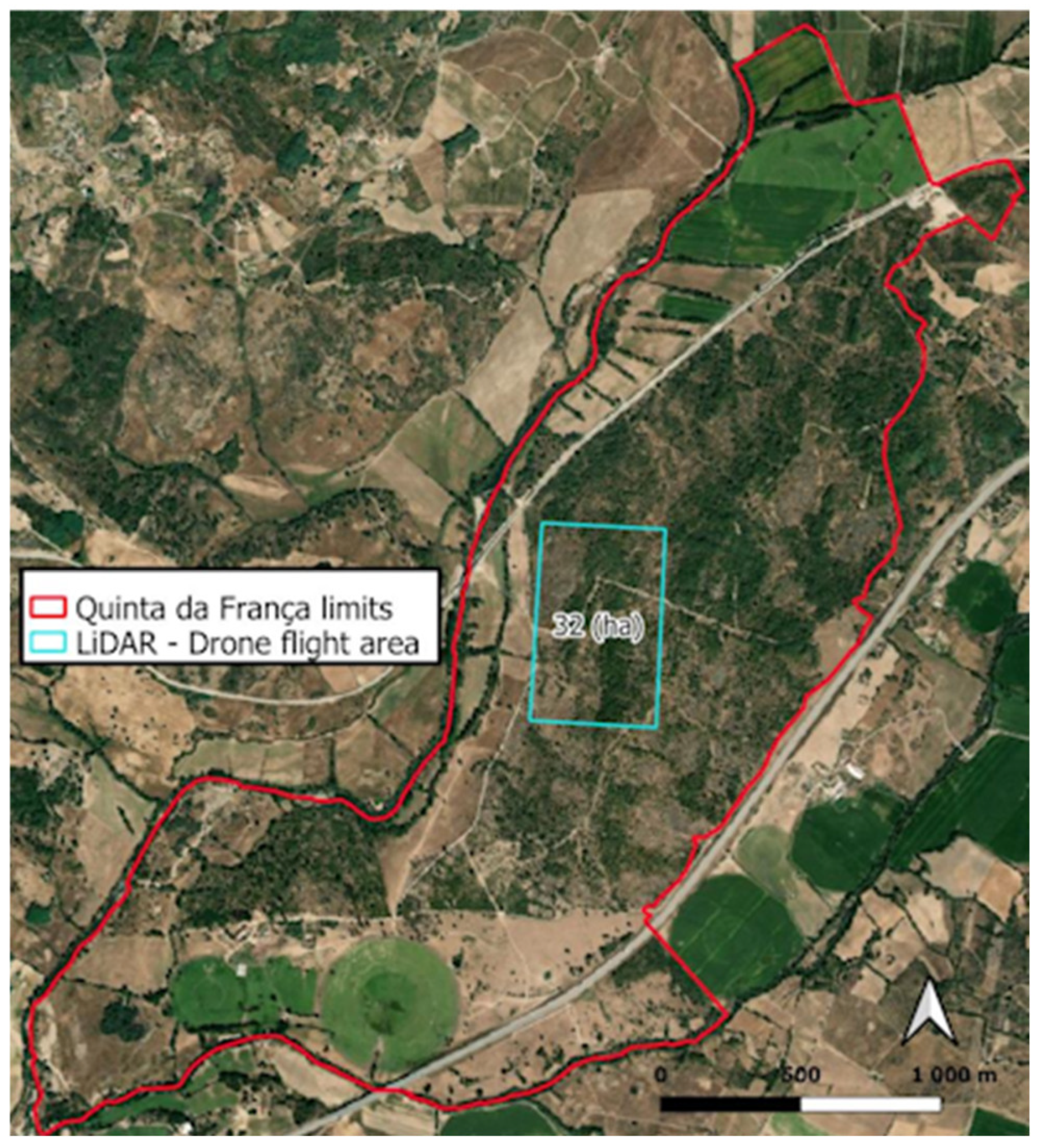
This case study is located at QF, an agroforestry farm covering a total area of 500 ha, in the Covilhã municipality in the Cova da Beira region in Portugal (Figure 1). This is a farm under agro-silvo-pastoral management, with multiple land uses, functions, and services, including agricultural and forest production, under conservation and restoration management practices. QF has a diverse and interconnected landscape mosaic management, with a large area of a native Pyrenean oak forest with the potential for a regenerated habitat (EU Habitats Directive, Annex I sub type 9230 pt—Galicio-Portuguese oak woods with Quercus pyrenaica), and agriculture areas of cereal crops, meadows, and pastures for livestock production (beef calves and dairy sheep), with multiple associated economic and ecosystem services, such as soil protection, water cycle regulation, timber and forage production, and recreation (https://www.terraprima.pt/en/area-de-actividade/4, accessed on 8 May 2025). This experimental site, managed by Terraprima, a small and medium-sized Portuguese enterprise (and a partner of the SILVANUS consortium project), offers a representative landscape mosaic of the region, encompassing a diversity of land uses and vegetation types. One of the core sites of QF is a 224-hectare forest of native Pyrenean oak (Quercus pyrenaica), where the monitoring, prescribed burning, and restoration activities are focused. This oak species is particularly relevant due to its ability to resprout and regenerate after fire, when a moderate disturbance pattern is maintained [45,46]. Such a regeneration capacity, in association with wetter understory environments, commonly found in mature oak stands, makes these forests fire-resilient [37,47]. The forest area also includes smaller patches of dominant mixed oak forest, primarily composed of planted coniferous species.
The Pyrenean oak (Quercus pyrenaica) forest is native to Southwestern Europe and characteristic of sub-Mediterranean mountainous regions, typically occurring at altitudes between 400 and 600 m, in transitional areas between sub-humid temperate and Mediterranean semi-arid climates. The annual average temperature is equal to 12.6 °C, and precipitation equal to 1012 mm [48]. Three types of forests once dominated this region during the Holocene: Pyrenean oak forests, mesotrophic oak–ash forests, and riparian alder forests. Human activity, especially since the Neolithic, replaced these with agricultural and later forestry uses. In recent decades, land abandonment has allowed native tree and shrub species to recover. Listed under the Habitats Directive (Habitat 9230), this forest plays a key ecological role in soil protection, water regulation, and biodiversity conservation, supporting a pioneer species in post-fire recovery areas. With a strong root system and high regenerative capacity, Pyrenean oak is resilient to fire and cutting, having a long history of silvo-pastoral use, being extensively managed for firewood production and livestock grazing.
The fire regime is generally characterised by a typical Mediterranean fire season, with most wildfires occurring during the hot and dry season (May to September). This is related to the regional climate characteristics of Cova da Beira based on two key factors: the hot and dry summers, and the wet and humid falls and winters. This is also influenced by the typical vegetation phenology that includes a growing peak in the spring, with longer daylight and rising temperatures, followed by a senescence dry biomass period in the summer, and thus, contributing to the wildfire hazard increase.
The occurrence of severe and intense wildfires is characteristic for the area, affecting large areas of shrubland and forestland in the region, with some severe wildfires having occurred in 2003, 2005, and 2022. The terrain is characterised by deep slopes, which are difficult for fire fighters to access. Along with the summer adverse climate characteristics and large areas of monoculture forest production regime, namely Maritime Pine (Pinus pinaster) and Eucalyptus (Eucalyptus sp.), a unique blend for intense wildfires is being created. Nevertheless, the agricultural mosaic, combined with the autochthonous Pyrenean oak forests in the pilot region, largely contributes to an enhanced resilience of the territory against forest fires. In contrast, agricultural practices such as burning for pasture areas, burning ended annual crops for the new seeding season, as well as the mechanical agriculture operations are being identified as contributing factors to unintentional and negligent fire ignitions.
Historically, the current QF oak forest area has suffered two major wildfires, in 1984 and 1995, which heavily affected most of the current pilot site. Since then, the forest has undergone natural regeneration, partially assisted through planting, and is now managed for conservation, fire prevention purposes, wood production for fuelwood, and grazing. Vegetation within QF is highly heterogeneous. The oak woodland includes unevenly distributed stands of varying sizes and ages, interspersed with open areas such as pastures and rocky outcrops, as well as shrub dominated areas, mainly brooms (Cytisus multiflorus and Cytisus scoparius). Hawthorn (Crataegus monogyna), Blackberry (Rubus ulmifolius), and Grey Willow (Salix atrocinerea) are also present. Some of the sparsely wooded or degraded areas have been replanted with pioneer conifer species, such as Maritime Pine (Pinus pinaster) and Cypress (Cupressus sempervirens and Cupressus lusitanica), selected for their high productive potential.

2.2. The Context of the SILVANUS Approach

Quinta da França’s forest management has been developed in the framework of the EU Horizon Europe SILVANUS project.
In the context of contemporary wildfire management, response agencies are developing and implementing innovative methods to improve wildfire detection, monitoring, and response. The SILVANUS project seems to advise that there is a need from agencies for more advanced, efficient, and proactive strategies, which produced the Integrated Technological and Information Platform for Wildfire Management.
Aerial imagery systems, through satellites with medium resolution (e.g., Sentinel-2, 10 to 60 m), or UAVs, with very high-resolution images (e.g., RGB cameras, 0.05 m), as well as ground-based sensors, can allow for the early detection of wildfires [49]. UAVs can support communication even in remote areas, providing the necessary technological means [50,51]. Nowadays, social media technologies [52] can support such kinds of detection and allow for improved communication between citizens and emergency responders [53]. Satellite imagery allows for easy and regular monitoring of vegetation, before and after wildfires, especially for post-fire rehabilitation but also for management purposes [48]. Various data combined in technological platforms that encompass modern Geographic Information System (GIS) capabilities can support decision making [54,55].
The notion of IFM as adopted within SILVANUS is depicted in Figure 2.
The Portuguese case study in the QF pilot site aligns with the IFM objectives, following an annual cycle that includes Phases A, B, and C, implementing a continuous action plan that covers all phases throughout the year, rather than concentrating efforts solely during the peak fire season (Figure 3).
The IFM objectives at the pilot site QF primarily focus on Phase A and Phase C, emphasising wildfire risk monitoring and preparedness for first-response actions, and sustainable forest restoration concerns. From the perspective of the sustainable agroforestry management framework at QF, some actions are accomplished in the different IFM phases.
The specific actions followed for the sustainable agroforestry framework are the following, based on the IFM and CTNFM approaches. Regarding the prevention and preparedness phase (Phase A), the following activities are carried out:
Implementation of frequent remote sensing monitoring;
Reduction in management costs through proactive planning of clearing activities;
Identification of terrain characteristics that may constrain or ease wildfire combat;
Maintenance of firebreaks;
Selective tree cutting pruning and thinning;
Livestock grazing and mechanical control to reduce fuel load; prescription of fire to control shrub biomass fuel;
Personnel engagement for wildfire prevention and preparedness—good practices adoption on forest management activities.
We considered the Phase C activities at QF; focused on the mitigation of trade-offs by the use of grazing for biomass management; aimed to avoid impacts on soil, biodiversity, and tree regeneration and to reduce greenhouse gases (GHG) emissions; and selected the right set of variables to assess restoration efforts.

2.3. Non-Grazing Interventions

2.3.1. Firebreaks

A clear and navigable network of firebreaks works as a prevention measure and is essential for effective firefighting. QF’s forest features an extensive network of firebreaks, ranging from 5 to 10 m in width, kept free of vegetation and obstacles. These firebreaks are typically aligned with fences and bound the forest management zones (Figure 4).
Together with fuel management plots, firebreaks are an art of the Integrated Forest Fire Defence Network (FFDN) as Fuel Management Strips (FMSs), a legal obligation defined by Portuguese law (Article No. 46 of Decree-Law 82/2021, 13 October). FMSs are divided as being of regional (primary network), municipal (secondary network), or local (tertiary network) interest. At QF, FMS networks are identified as being of municipal and local interest, and the vegetation must be managed and controlled according to the definitions of the Municipal Forest Fire Defence Plan to reduce the spread of fire, protect communication routes and infrastructure, and isolate potential ignition sources. Within the FFDN, we can also consider green fire belts, which comprise the agricultural parcels (rainfed and irrigated) of QF, and the riparian vegetation corridors along the two main rivers (Rio Zêzere and Ribeira de Caria) that border the farm.

2.3.2. Mechanical Shrub Control

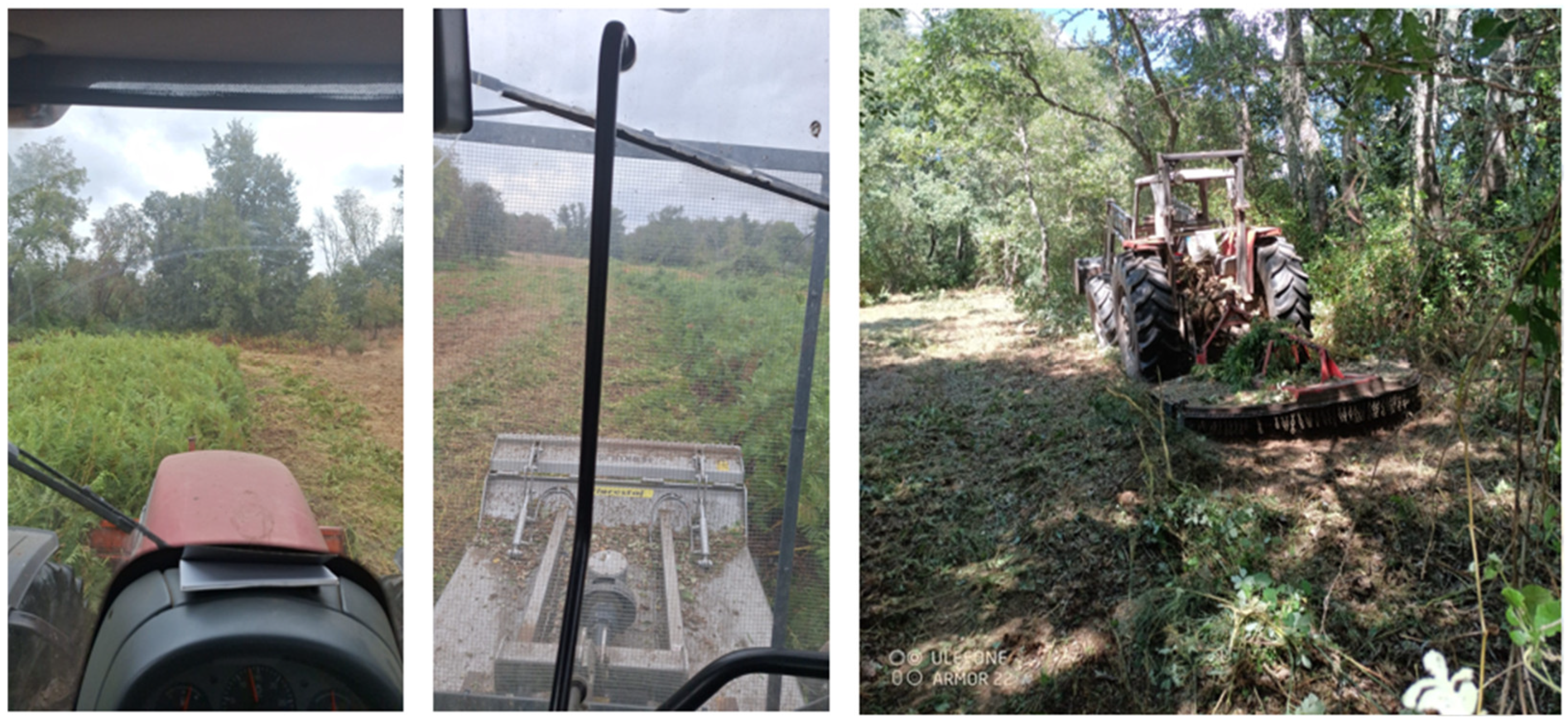
Shrub control at QF is performed as a prevention action, with a shrub shredder, to reduce understory biomass and prevent intense forest fires, whilst minimising soil perturbation (Figure 5).
Mechanical vegetation treatments such as mastication, shredding, and thinning are increasingly used to reduce wildfire fuel loads and modify fire behaviour. These methods disrupt vertical and horizontal fuel continuity, decreasing flame heights and the likelihood of crown fires. For example, Ref. [56] demonstrate that mechanical mastication in Australian shrublands significantly reduced predicted flame heights without harming native biodiversity. Long-term monitoring by [57] showed that shrub suppression and reduced fine fuel loads persisted up to nine years post-treatment. In forest ecosystems, the early work by [58] confirmed that mechanical crushing effectively reduced fire hazards in ponderosa pine slash. Additional studies [59,60] found that combining mechanical thinning with prescribed burning offered the greatest reduction in fuel hazard, particularly in eucalyptus and Mediterranean pine forests.
Mechanical biomass control in a forest environment needs to fulfil some terrain and vegetation conditions; namely, it is not possible to operate in high slope or rocky surfaces, especially to avoid machinery rollover and non-optimised route paths, with obstacles to bypass or inaccessible areas. It is also not possible to work in a dense forest where the machine cannot pass.
Mechanical shrub control allows for greater selectivity and is a good practice for places where other techniques cannot be used, either because of the morphological conditions of the area or the presence of protected or ecologically sensitive species or plant communities.
Mechanical shrub control techniques should also consider labour and fuel costs. Its cost is higher than that of grazing but lower than that of a prescribed fire, but in QF, a combined solution seems to be the most efficient because it is possible to implement different approaches to reduce fuel biomass according to the different terrain and vegetation conditions.
Several studies have evaluated the combined effects of mechanical treatments (e.g., thinning or mastication) with prescribed fire and/or grazing on reducing biomass and mitigating wildfire risk [61,62]. The utilisation of integrated approaches frequently results in the attainment of more effective and sustained outcomes in comparison to those achieved by single-method treatments [63,64,65].
It is very important to emphasise that QF management does not use tillage as a means of mechanical shrub control, only surface cutting of biomass with no (or very little) soil disturbance. All shredded biomass and fine debris are spread and left in the field, not piled, on the topsoil layer, for organic decomposition, contributing to and transforming into soil organic carbon. In this way, there are several ecosystem benefits, such as protection against soil erosion and increased soil carbon input. Also, this is performed rotationally, in widely spread areas, reducing any additional temporary fire risk.
The retention of fine woody debris following mechanical forestry treatments has been demonstrated to enhance soil moisture, organic carbon, and microbial activity, thereby promoting soil health and augmenting carbon sequestration [66,67]. While the implementation of fine woody debris can lead to an augmentation in surface fuel loads in the short term, the distribution of fuel, heightened moisture content, and the suppression of shrub regrowth contribute to a reduction in fire risk over time [68].
The implementation of optimal practices, such as the avoidance of the accumulation of vegetation (i.e., piles), the utilisation of prescribed fire, and the monitoring of fuel accumulation, is conducive to the preservation of soil integrity and the enhancement of forest fire resilience.

2.3.3. Prescribed Burning as a NbS

The way nature-based solutions (NbS) are used to mitigate climate change-induced disturbances, such as wildfires, is crucial. As already mentioned, the key to effective wildfire risk management is a reduction in fuel loads in forests wherever it is needed and possible. Methods to achieve fuel reduction and promote forest health include, but are not limited to, grazing (Section 2.4) and prescribed fires [69]. There are plenty of scientific studies that contextualise prescribed burning as a valuable NbS for mitigating wildfire risk and promoting overall ecosystem health. These studies rigorously examine the practice and highlight its potential to substantially reduce hazardous fuel loads, thereby decreasing the intensity and spread of wildfires. Furthermore, they demonstrate how prescribed burning can create more resilient landscapes, better equipped to withstand future disturbances, and enhance biodiversity by promoting diverse plant communities and creating varied habitats. The evidence is particularly compelling from Mediterranean ecosystems or similar fire-prone contexts, where long-term monitoring and research have rigorously demonstrated the overwhelmingly positive effects of prescribed burning [19,70,71,72].
Prescribed burning (PB) can be described as the planned use of fire to achieve defined and precise objectives in a more appropriate and controlled manner, leading to the evolution of a less risky approach when compared with the traditional agricultural burnings [73]. Also, PB consists of “small-scale, low-intensity, controlled fires ignited to achieve specific land management objectives, including wildfire prevention and ecological or agricultural management” [74]. In the literature, there are references for several kinds of PB and its application. Prescribed underburning (PUB) is related to the use of PB in a forest stands, and in southern Europe, PUB is primarily used to reduce wildfire risk, while supporting goals like pasture maintenance or biodiversity conservation are typically secondary [75]. PUB is more appropriated for forests with excessive understory growth, and the main purpose is to reduce the biomass (shrubs and grasses) without harming mature trees, thus avoiding the ladder fuel effect—a pathway for fire to move vertically, from the ground to the tree canopy—in an uncontrolled forest fire situation. Thus, PUB involves applying PB within forest stands in a way that targets only the vegetation beneath the tree canopy. These burns are typically carried out at low to moderate intensity to eliminate accumulated surface fuels and reduce the risk of severe wildfires [75].
PB requires following defined protocols, determining what type of vegetation will be burned, the purpose of the burn, and the specific areas where it should take place. It also involves deciding the appropriate timing and methods to ensure the goals are achieved. This process includes developing burn prescriptions that consider weather conditions, topographical and fuel moisture situation, the time of year, and ignition techniques, as these elements influence how the fire behaves and the effects it will have [75]. In Portugal, PB must follow the rules of the National Plan for Forest Fire Prevention and Protection (PNDFCI—Decree Law 156/2004 & 124/2006) that established the legal basis for prescribed and controlled burning, defining that only referenced technicians may use technical fire, outside the wildfire season—and only when the fire risk index is low [76]. Updates in 2009–2014, for the PB definitions were refined, including responsibilities expanded to include municipal bodies and civil protection authorities [77].
The Mediterranean climate seasonality is determined by dry and hot summers and rainy winters. This climate regime contributes to boom biomass growth during the spring, which becomes fuel material when dried in summer. Due to these climate and vegetation conditions, it is not appropriate to apply PB in the hot and dry periods, avoiding the risk of uncontrolled burning. On the contrary, PB should be performed in the periods of the cold season that could provide fire ignition and propagation conditions, but in a more controlled situation, i.e., with low air humidity, no recent rainy days, ensured presence of dry thin vegetation and dry leaves in the topsoil, low air temperature, and low wind conditions.
The use of PB during the cold season seems to be an efficient and good practice for wildfire prevention to control the biomass and reduce fire hazard and fire severity during the hot and dry season, contributing also to other ecological gains by maintaining open habitats, thus promoting the renewal of dominant vegetation by controlling invasive species but not affecting the soil properties [73,78,79]. Moreover, PB appears to have higher cost-effectiveness compared to other fuel treatments [78,80,81] and could be used in various fire-adapted vegetation types worldwide [78,82,83,84,85].
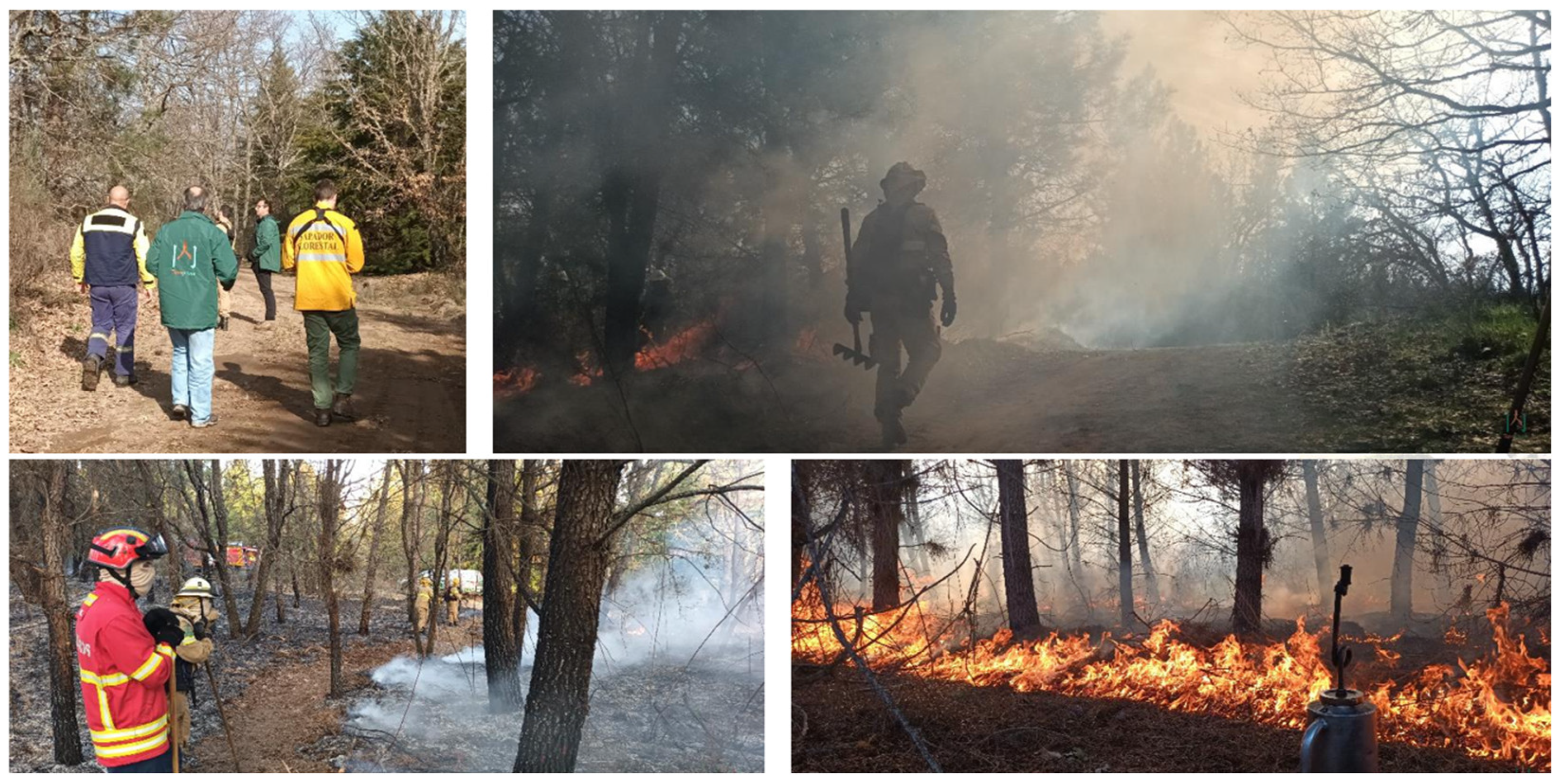
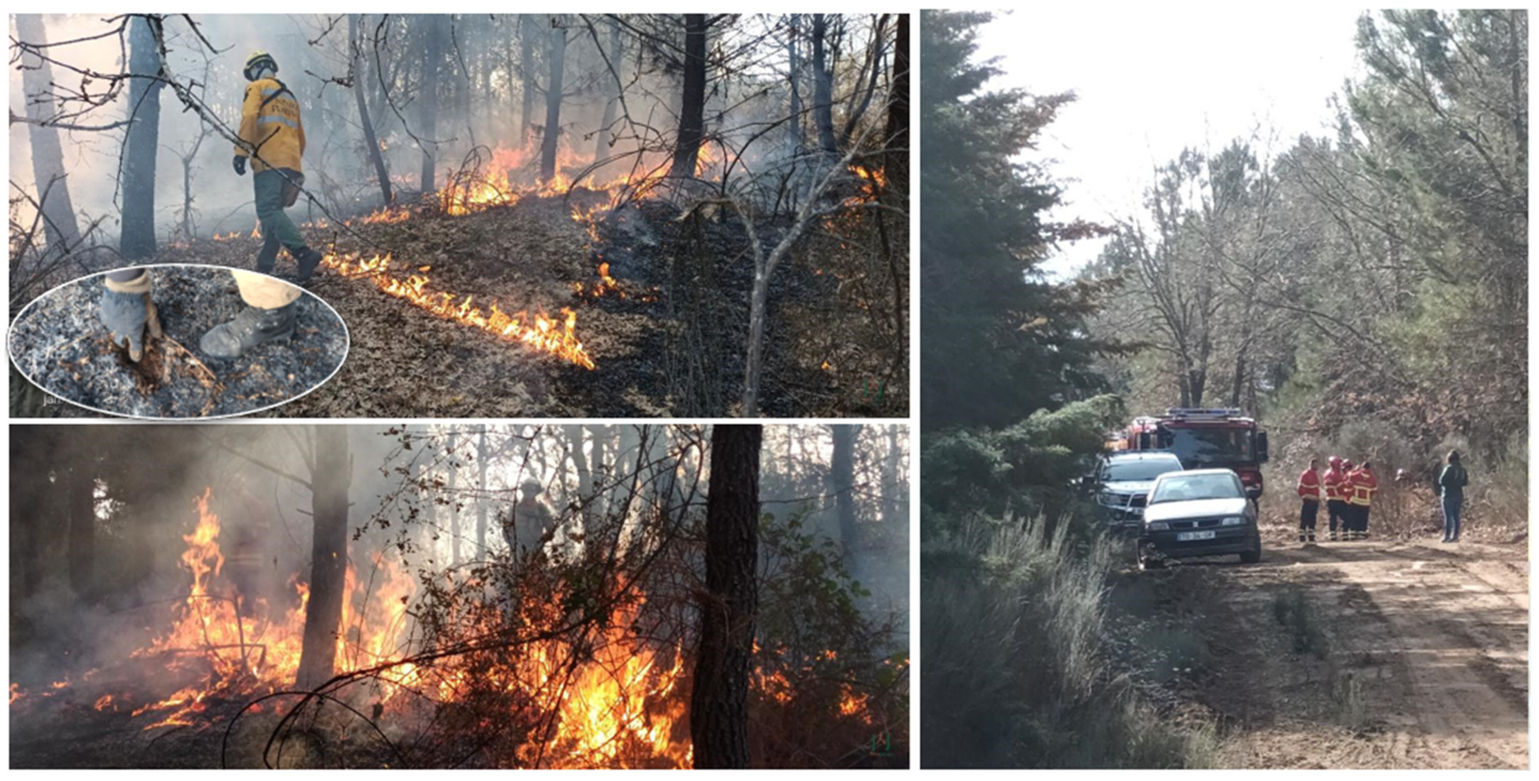
Quinta da França had a forest management trial with PUB, with the presence of fire experts and the authorisation of the local competent authorities in January 2024 (Figure 6).
The right use of PUB, under adequate weather conditions (air temperature, moisture, and wind speed) allows for the implementation of controlled burning with low fire intensities and lower fire temperatures, which do not affect the living trees and the topsoil mulch (Figure 7).
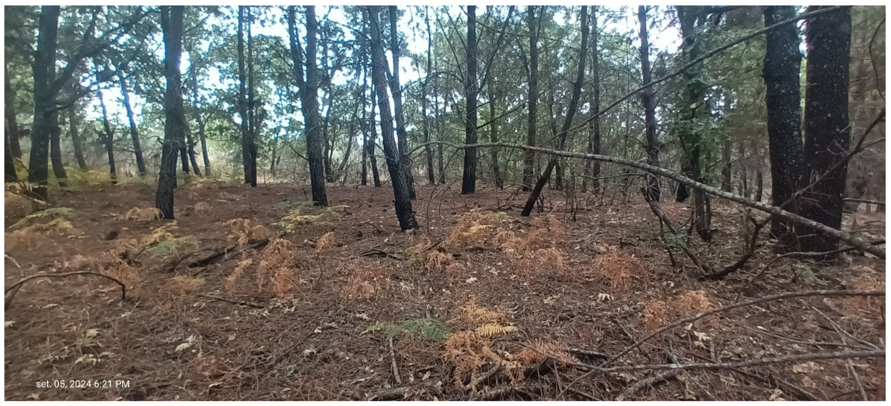
As a result of correctly executed PUB, with low fire temperature and intensity, the understory biomass is reduced and the vegetation loses its vigour for the next germination season, but the trees are not affected (Figure 8).
Nevertheless, the shrub biomass reduction resulting from PUB could also vary depending on the frequency of burning interventions and the type and age of the shrub vegetation [86]. One single PUB may not be sufficient to remove most of the shrubs; thus, it may require further burning repetitions, or to be complemented with other actions, such as mechanical or grazing interventions [87]. Excessive PUB frequency can diminish biomass but also the biodiversity [88]. Repeated burns can lead to a durable reduction in shrub cover, and references suggests that understory shrub biomass recovered in approximately 10–12 years, offering a benchmark for potential burn repetition cycles [89], at a rate rotation of PUB of approximately 10 years.

2.3.4. Selective Tree Pruning and Thinning

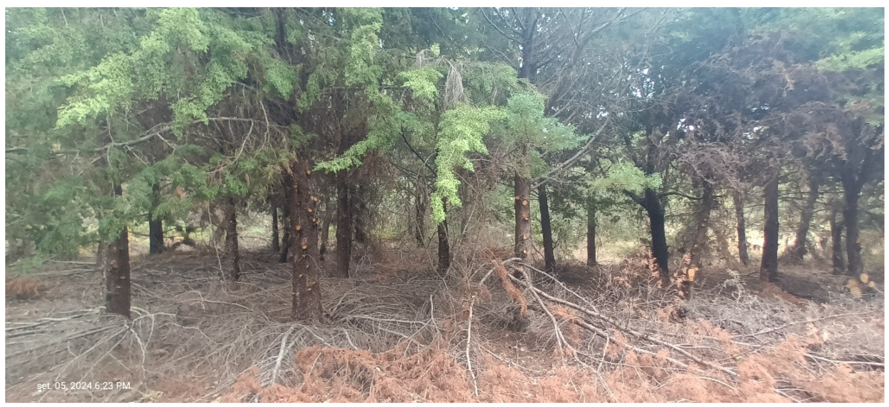
Selective tree pruning and tree thinning were performed at Quinta da França’s forests for fire prevention Phase A and restoration Phase C and were mainly applied in the non-grazed area. The tree pruning and thinning were carried out intensively in all of QF’s forest under two main forest projects in 2001 and 2002. In the subsequent years, these operations were performed mainly in northern, non-grazed area of the forest under a regular basis, with more focus on coniferous curtain spots (Cupressus sp.), alongside the forest paths and firebreaks (Figure 9), also in some patches of mix oak forest groves, for firewood production.
The mechanical pruning technique involves the use of machinery, such as chainsaws, so it also applies the same principles of forest management interventions’ period that was described for mechanical shrub control. The objective for this intervention is to reduce the biomass in a vertical layer by cutting the lower branches of the trees, creating a discontinuity of fine biomass from the ground to the canopy.
This operation is complemented by selective tree cutting–thinning, with two main objectives: one is to reduce the tree density in some areas, reducing the canopy contact and creating open areas and forest clearings; the other is to promote the formation and faster growth of some tree specimens. Finally, there is the selective cutting of dead or visibly diseased or weakened trees.
The rationale behind these operations is mainly to reduce the biomass, either in vertical or horizontal discontinuities, by introducing discontinuities in the forest landscape mosaic that, on one hand, contribute to hindering fire propagation and, on the other hand, facilitate firefighting and mobility. Ecological and hunting aspects also benefit from these interventions, as they create open areas and promote natural pastures for wildlife and cattle grazing.
In the southern grazed area of the forest, the livestock produces an effect of biological thinning, which is a natural process that mimics or complements human thinning efforts in forest management.
The sustainable management of the QF forest through closer-to-nature silviculture treatments should facilitate sustained tree growth and forest biomass over time, leading to a more mature forest with greater resilience to forest fires.

2.4. Grazing

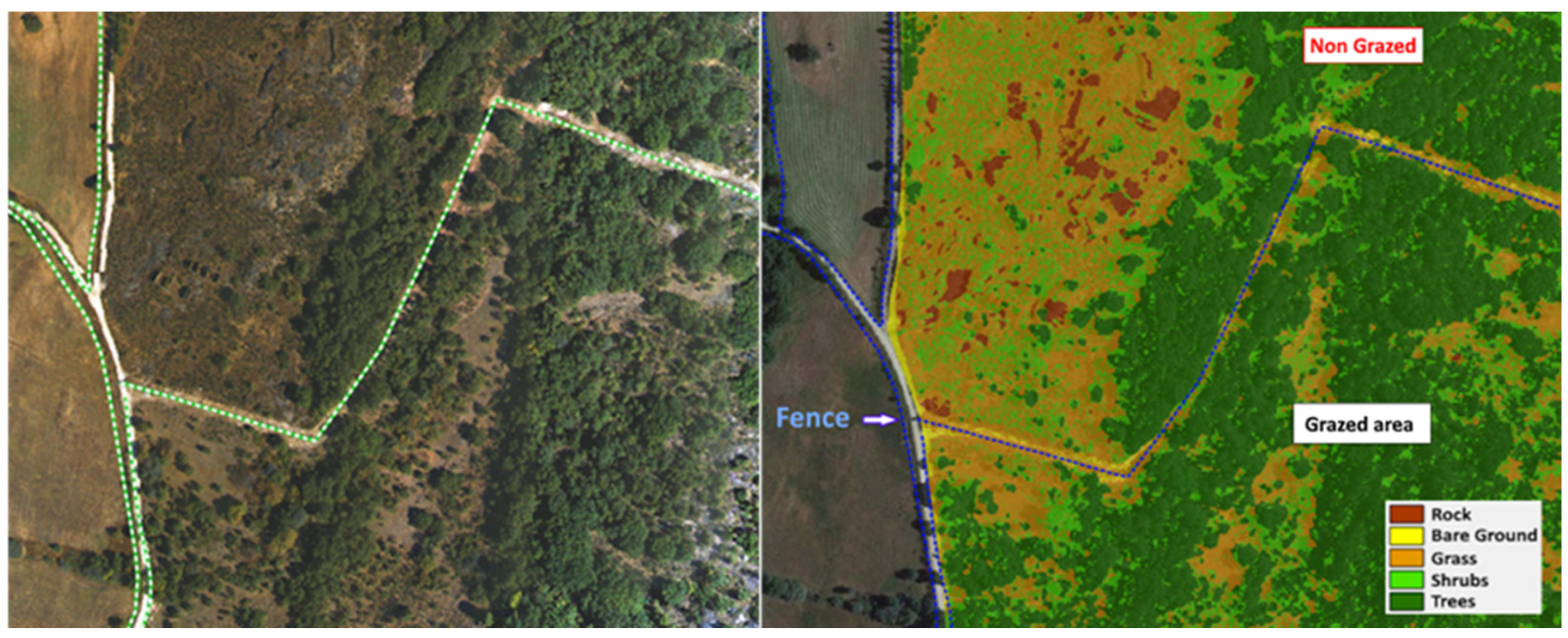
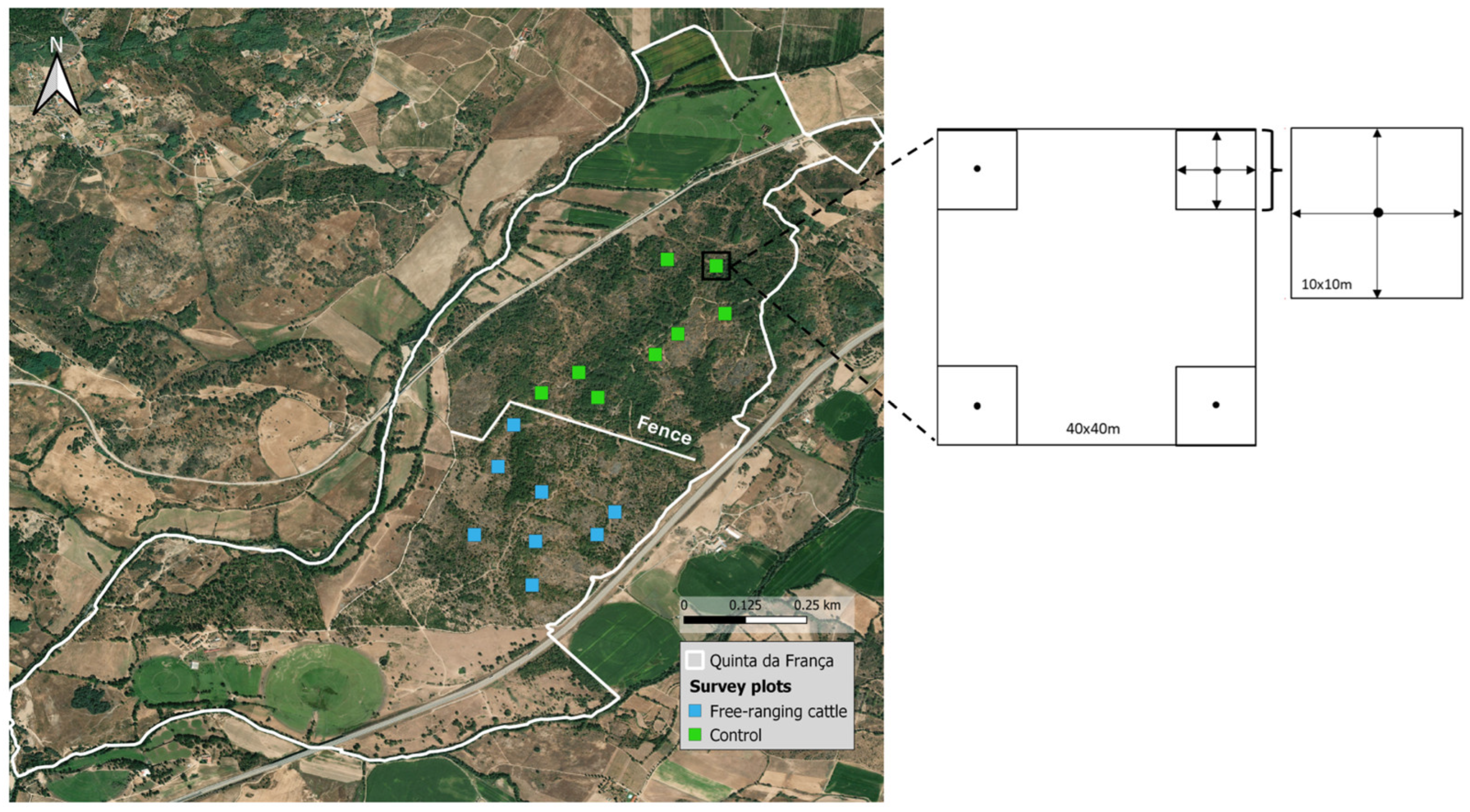
In 2018, a fence was installed to divide the QF’s Pyrenean oak forest into two approximately equal areas with different management: grazed (100 ha) and non-grazed (124 ha) (Figure 10). At QF, the livestock consists of a herd of adult Limousine and Angus crossbred cows, with their calves up to six months of age, along with two adult Angus bulls. The grazed area follows a moderate-intensity grazing system, with free-ranging cattle stocked at 0.2 livestock units per hectare. The herd, managed primarily for beef production, also utilises nearby pasture areas of QF farm, adjacent to the forest [90].
The cattle graze freely year-round, with increased pasture use at the Pyrenean oak forest grazed area typically occurring between February and June.
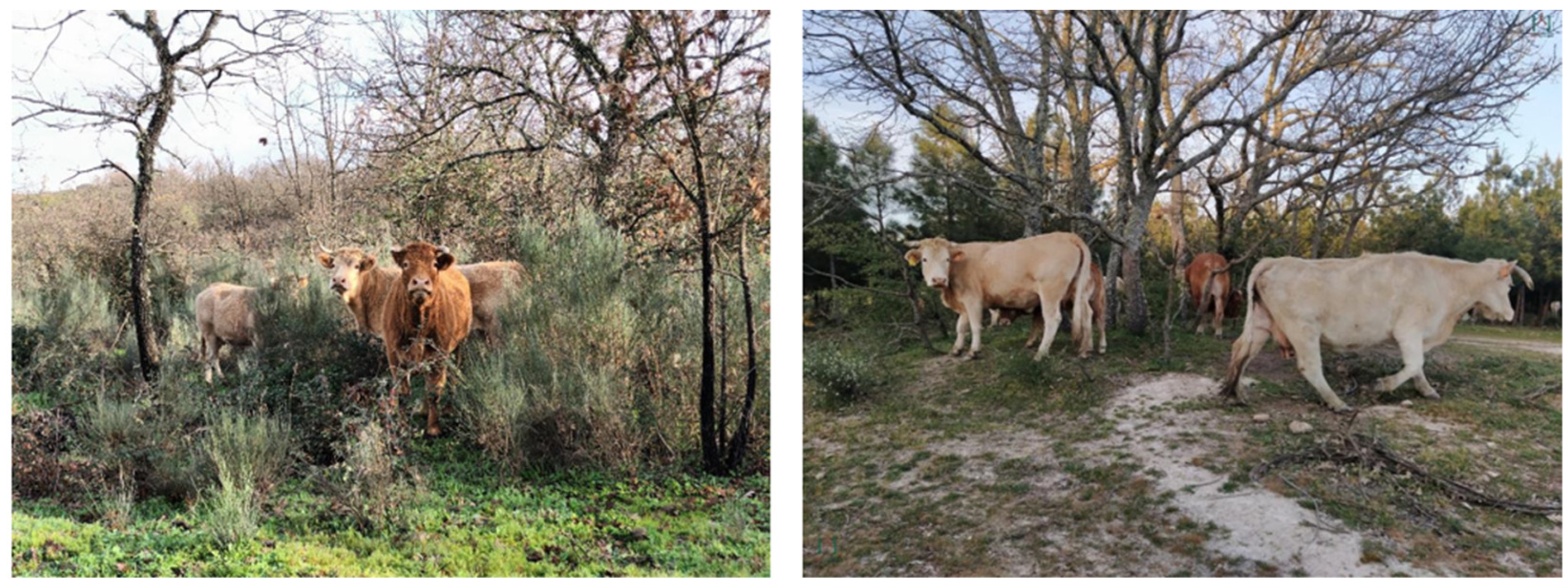
In this period, the forest provides abundant green grasses, young tree shoots from tree growth and regeneration, and acorns, which serve as highly nutritious food resources for cattle in the extensive beef–calf production system. Additionally, the forest offers a natural refuge for cattle, sheltering them from harsh winter conditions (Figure 11).
To enable a comparative study of grazing effects, livestock grazing was implemented to only half of the forest. The south side of the fence was opened to a herd of approximately 60 beef cows, which grazed freely during part of the year, while the north side remained ungrazed. To assess the effects of cattle grazing on vegetation structure, field data on vegetation structure were collected at both grazed and ungrazed sites from 2018 to 2021, and remotely sensed data were analysed for the period 2016–2021 (two years before and three years after grazing began).
Livestock grazing acts as a nature-based solution (NbS) contributing to a more cost-effective method of controlling local fire hazards by regulating vegetation quantity and spatial distribution and maintaining fuel discontinuity [87,91,92,93]. This discontinuity should occur both horizontally, in the form of open pastures (i.e., the silvo-pastoral mosaic), and vertically, by reducing understory vegetation and limiting ladder fuels that can facilitate fire spread [90,94].

3. Methods

3.1. Remote Sensing

Land surface and land cover are primarily monitored through remote sensing imagery. Remote sensing, and data imagery collection for land cover mapping, stands as a fundamental tool for vegetation assessment. The literature commonly refers to remote sensing as a primary source of data in terms of vegetation mapping, and the range of applications in vegetation assessment is very diverse, covering vegetation monitoring for ecosystem structure and function, plant communities, biodiversity, health condition, and restoration status, for instance, in the evaluation for forest resilience from a pre- and post-forest fire situation point of view [95]. In this sense, remote sensing is a valuable tool for forest management, planning, and decision making. Remote sensing is mainly carried out with Earth Observation (EO) equipment, such as satellite imagery, with a major potential to cover large areas at a lower cost, alongside continuously and regular data collection. However, satellites face limitations, mainly due to insufficient spatial, spectral, and temporal resolution but, also, from cloud cover light reflectance blocking and suitable imagery failure [95]. This can be mitigated with the use of UAVs for low-altitude imagery data collection.

3.1.1. Satellite Monitoring

Sentinel-2 data imagery is a powerful tool for Earth Observation (EO) and land cover mapping production. The primary objective of the use of Sentintel-2 data images in forest model management is because its mission is especially appropriate for vegetation and land monitoring, with additional applications including agriculture, forestry, land use, and disaster response. Furthermore, the temporal and spatial imagery coverage is delivered at a resolution scale that is compatible with forest model management and provided free of charge. Sentinel-2 offers 10–60 m resolution and 290 km swath width, delivering global coverage every five days. Its open data policy supports wide use in science and environmental monitoring [96,97].
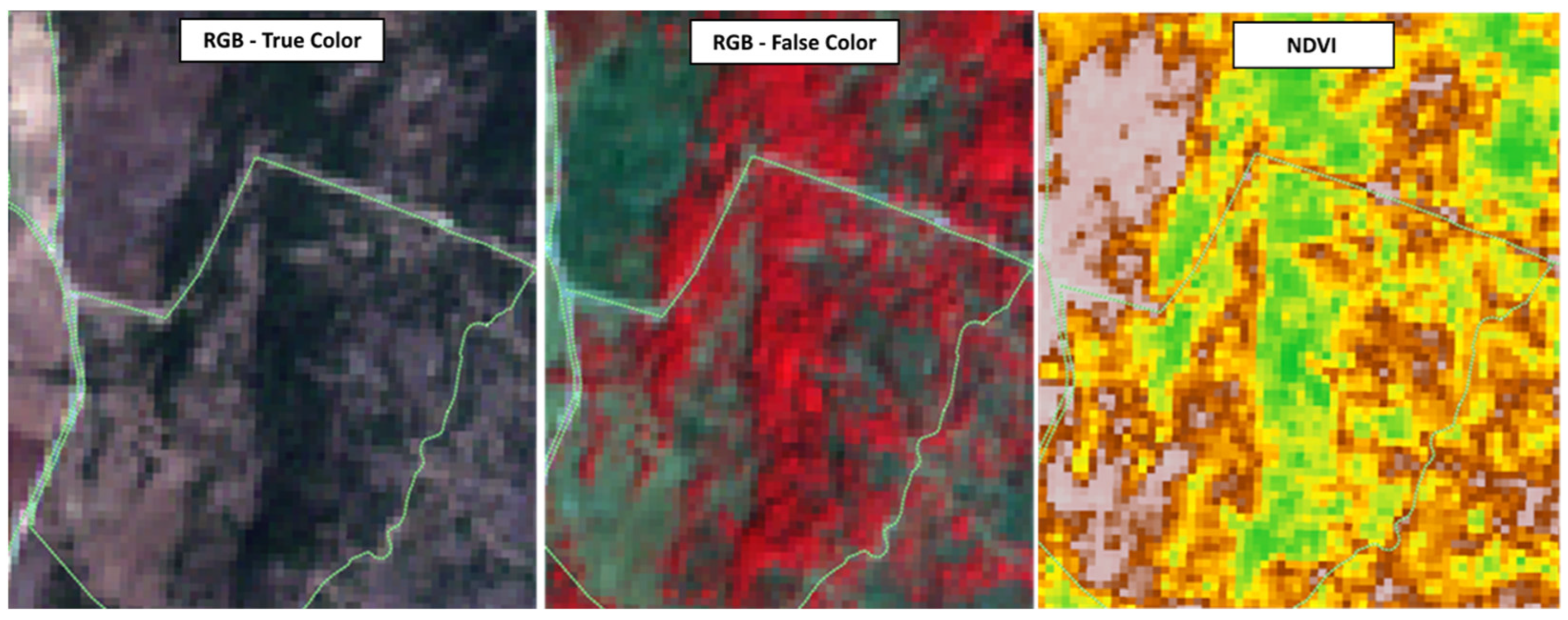
The remote sensing data acquisition of Sentinel-2 imagery for QF is an automatic procedure implemented with two main objectives: first, for real-time data mapping and land cover monitoring, and second, for historical time-series analysis and modelling. A large volume of gathered data is critical for land cover mapping evolution, training of machine learning models, biomass assessment, and forest management planning. At Quinta da França, this is carried out with weekly satellite imagery acquisition. All Sentinel-2 satellite bands are stored in a database, from which multiple combinations are obtained, like the combination of visible Red, Green, and Blue (RGB) bands for true and false composite colour images, or the calculation of vegetation indices such as the Normalised Difference Vegetation Index (NDVI). The RGB false colour image is appropriate for vegetation, and NDVI is a widely used metric for assessing vegetation health and density, as an indicator of greenness vigour [98] (Figure 12).

3.1.2. UAV Monitoring

Seasonal drone (or unmanned aerial vehicle (UAV)) flights are carried out at Quinta da França with a multirotor hexacopter, with 6 brushless motors and APM Pixhawk central flight command, equipped with rechargeable batteries of four-cell (4 s) lithium-ion polymer (LiPo), with a power capacity of 6600 mAp or 10,000 mAp at 14.8 v. The drone flights are performed at a mean low altitude of 80 m, at a mean flight speed of 5 m/s, with 60% side and 60% frontal imagery overlapping, and with aerial photos taken at each 5 s to collect high-resolution (0.02 to 0.04 m) land surface imagery collection and for posterior ortophotomap processing. The UAV payload is equipped with two cameras: (1) a Red, Green, and Blue (RGB) camera, from the brand manufacturer GitUP2, and (2) a near-infrared (NIR) camera, from the brand manufacturer MAPIR. Both cameras are equipped with a Panasonic sensor—MN3120PA. Camera 1 has a single light spectrum filter in the 370–680 nm range, and camera 2 has a dual-pass filter for Red at 660 nm and for NIR at 850 nm of the light spectrum. The image data collection from these two cameras contributes to produce high-resolution visible true-colour and false-colour ortophotomap images, high-resolution NDVI images, and high-resolution land cover map products (Figure 13). The drone flights are performed in different time seasons to capture the vegetation phenology cycles. LiDAR (Light Detection and Ranging) data acquisition is also performed using drones for biomass assessment.

3.1.3. Land Cover Maps

Land cover maps have particular importance in forest monitoring and management, especially regarding wildfire prevention. High-resolution land cover mapping and shrub cover mapping is an efficient tool to address vegetation evolution and condition, mainly in Mediterranean ecosystems and, in particular, at the QF pilot site, characterised by a fine-grained heterogeneous land cover, with shrub encouragement after land abandonment and fire [99].
Earth Observation (EO) and satellite (Sentinel-2) imagery collection and time series data analysis, crossed with the validation from the high-resolution land cover map (drone flights outcome), were used for the development of machine learning models for shrub cover percentage mapping at QF [95,99] (Figure 14). Areas with 0% cover were also identified and mainly correspond to the rocky or bare ground. The shrub cover map does not identify the understory cover that corresponds to the trees in the land cover map.

3.1.4. Vegetation Vigour

Indexes can be driven from remote sensing data (EO and UAV) by the combination of bands and used for describing land cover conditions, water, vegetation, and soil. One of these indexes is the Normalised Difference Vegetation Index (NDVI).
NDVI is a metric used to quantify vegetation greenness. It is a valuable tool for understanding vegetation density and assessing changes in plant condition. The NDVI makes use of two Sentinel-2 bands, namely the red (R) and near-infrared (NIR) values [100,101]:
N D V I = N I R R N I R + R
NDVI is a widely used indicator for measuring various factors related to ecological parameters, including canopy density, biomass, plant health, and vegetation productivity [102,103,104]. Furthermore, the same studies also found NDVI to be effective in the assessment of vegetation damage, stress, and recovery. NDVI time series monitoring using remote sensing images can be used to determine vegetation growth and recovery.

3.1.5. Biomass Estimation

From the industrial perspective, biomass estimation helps, at least in two dimensions, vegetation maintenance planning and CO2 capture market participation. Biomass estimation results from either the vegetation volume multiplied by the species-specific wood density or through the use of region-specific allometric equations. For the first method, vegetation volume can be calculated from rather precise processes like Light Detection and Ranging (LiDAR) 3D point cloud acquisition and classification [105]. On the other hand, although satellites cannot provide vegetation volume data by itself, they can be combined with other data sources and models to bring up an improved estimation, at lower costs and at higher monitoring rates, compared to LiDAR campaigns. These last two are important factors for private companies to move towards methods driven by satellite imagery.
Here, a method that correlates low-resolution free Sentinel-2 imagery to high-resolution LiDAR data for a specific area is proposed, producing an Artificial Intelligence (AI) model that estimates vegetation volume from the former. Since biomass and vegetation volume have a linear relationship, as explained before, the former can be easily calculated, so in the following lines, the attention will be drawn to vegetation volume.
Traditional analytical methods were overtaken by AI methods due to less adaptability in what concerns context change, scalability, and noise robustness. Concretely, the present AI model was trained to match satellite imagery detection to the high-resolution LiDAR data, obtained from UAV flights for any region, which increases its replicability, i.e., its potential adoption by different entities managing forest areas or infrastructures that may benefit from wildfires low-investment prevention strategies.
The model training process was based on three steps:
  • In a given area, vegetation classes (types/species present in that area) are identified. Usually for maintenance purposes, three vegetation classes are considered: trees, shrubs, and grass.
  • Vegetation volume is extracted per class, in the area, overlapping LiDAR data.
  • A machine learning model is applied, making use of satellite imagery (10 × 10 m) to estimate the volume per class.
In this case, a ResNet (Residual Network) machine learning model was used as a template. A ResNet is a type of deep neural network that uses shortcut connections to skip layers, allowing it to train very deep architectures without the vanishing gradient problem. On the other hand, it requires careful use to avoid overfitting (e.g., if the training sample is small) and a rather powerful infrastructure to run the training.
LiDAR data of biomass volume over part of QF, with a spatial resolution of 1 × 1 m, was acquired. Between March 2023 and October 2024, a total of five LiDAR data acquisition campaigns were realised, covering all four seasons and taking advantage of a clear sky—for satellite imagery matching—during each drone flight.
For each of the five campaigns, the training process used 80% of LiDAR files to train the model and 20% for testing. On each campaign, an amount of 15 GB of LiDAR files and compressed TIFF images were acquired from drone flights.
This straightforward training strategy was chosen due to the available training infrastructure—the Azure 1 GPU server.
The resulting 3D maps fed a machine learning image segmentation model that uses 10 m resolution Sentinel-2 images to infer the vegetation volume maps. Figure 15 shows the rectangular area (in blue) considered in the current study.
The evaluation metrics used for the abovementioned model were Root Mean Squared Error (RMSE), Mean Absolute Error (MAE), and Coefficient of Determination (R2). The values reached are presented in Table 1.
As one can infer, given that pixel values range from 0 to 255, an MAE of 0.618 suggests an acceptable level of accuracy in preserving the pixel values during downscaling in the case of high- to mid-level density vegetation. The moderate accuracy and fair ability to extrapolate from satellite low-resolution imagery is still useful for vegetation maintenance and biomass first estimation. For instance, in a shrub-predominant area where biomass may reach 3 kg/m3, a deviation of 0.618 kg/m3 may occur in reality, which is acceptable.
In practical terms, this deviation is not significant, neither for shrub classes nor for trees. It becomes more important when one considers grass growth, especially in narrow areas around critical infrastructures where a large volume of grass, not spotted, might become a potential source of fire ignition—at high risk.
The above conclusions are corroborated by the RMSE, which is of the same dimension.
An R2 equal to 0.537 indicates that the model is still able to predict vegetation volume in half of the areas returned by satellite imagery. This value shows that the model is not ready for exploitation but is a good starting point for the chosen model—ResNet.
There is room for improvement, namely feature engineering and hyperparameter tuning. Also, acquiring higher-definition satellite imagery will, for sure, improve the model’s metrics values, helping also reduce the deviations achieved, which as discussed above, are not acceptable for areas where grass takes over most of the field.
To have an empirical idea of the potential of this approach, in Figure 16, the biomass model inference process is illustrated in brief.
The ResNet architecture is typically used for image classification. CNN (Convolutional Neural Network) and FCNN (Fully Convolutional Neural Network) were also tested, although with weaker performance. As a note, several other architecture experiments were made to optimise the amount of pixels passing into the model.

3.2. Fieldwork

3.2.1. Forest Inventories

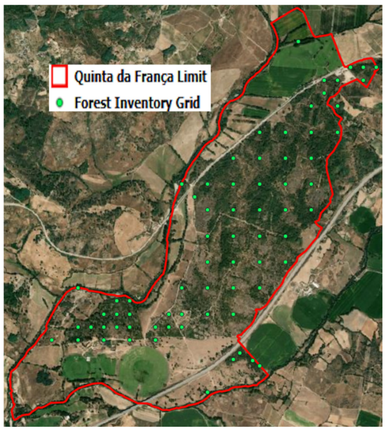
The Quinta da França forest is subject to regular monitoring through forest inventories (FIs). These FI are conducted on a regular 250 m × 250 m point grid within the forest (with higher resolution in smaller parcels), with the aim of measuring tree dendrometric variables, including total height and diameter at breast height (DBH), used in allometric equations for tree density and biomass calculation. In addition, the forest’s condition and tree health are monitored during the FI (Figure 17).

3.2.2. Vegetation Survey

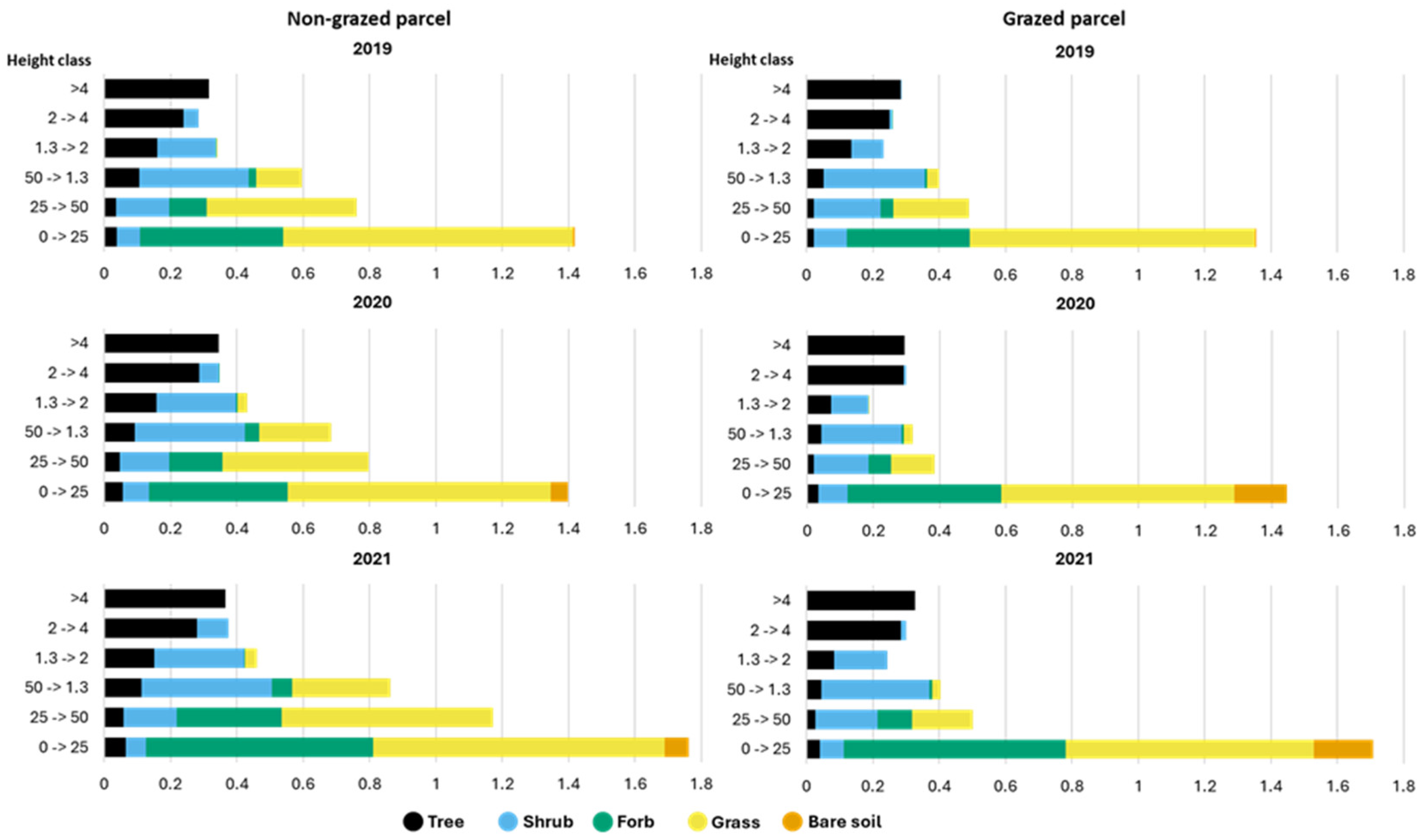
Vegetation structure is surveyed at QF in 10 m × 10 m sampling plots (Figure 18): vertical vegetation profile is surveyed in four perpendicular transects of 5 m from the centre (maintaining a 90° angle, or as close as possible, between them). Vegetation type (grasses, forbs, shrubs, and trees) and height class (0–0.25 m; 0.25–0.50 m; 0.5–1.3 m; 1.3–2 m; 2–4 m; and >4 m) or bare soil, were registered at the centre and at every metre of the transects (i.e., in a total of 21 registration points per sampling plots).

4. Results and Discussion

The silvicultural treatments implemented in QF adhere to closer-to-nature principles, focusing on sustainable and ecologically sound management. This involves several key strategies:
  • Promotion of Natural Regeneration, Partially Assisted through Planting: After two major wildfires, the area of where QF’s forest currently lies underwent significant natural regeneration, with native oak, shrubs, and other vegetation returning. However, regeneration quality was hindered by factors such as the absence of mature trees and pockets of invasive species like Acacia dealbata, Acacia melanoxylon, Ailanthus altissima or Opuntia ficus-indica. To support recovery, human-assisted interventions, including thinning and pruning of the natural regeneration of oaks and targeted planting of pine and cypress saplings, have accelerated growth, stabilised soil, and improved biodiversity, bolstering ecosystem resilience.
  • Partial Selective Thinning for High-Value Trees: Low-intensity thinning was employed, prioritising the retention and promotion of trees possessing the highest economic or ecological value. This meant favouring valuable, well-shaped, broadleaf trees with high market potential, while also conserving trees, aiming for the expected ecological benefits.
  • Maintaining Species Diversity: A key aspect was maintaining and preserving all naturally existing tree and understory plant species. No native species were removed solely based on their identity; instead, the focus was on optimising the overall composition and structure of the forest.
  • Promotion of Multi-Stratified Structure for Wildfire Resilience: The silvicultural treatments actively promoted a multi-stratified forest structure. This means creating a forest with fuel gaps, vertically and horizontally, and multiple layers of vegetation—from the understory to the canopy—rather than uniform, evenly aged, single-layered, monoculture stands. This higher forest structure and landscape complexity is strategically important for reducing the risk of large wildfires. Specifically, the layered structure breaks the continuity of fuel, reducing the ease with which fire can spread through the vegetation. Thus, fire would only play its natural ecological role.
  • Selective Understory Clearing: In addition to the above, the understory vegetation was subject to partial, selective clearing. This was not a complete removal of the undergrowth but rather a targeted approach to manipulate the understory density and composition, potentially to improve light penetration for desirable species, reduce competition, or further enhance wildfire resilience by creating fuel breaks.
The results of the silvicultural treatments were assessed by QF’s forest composition and structure, as described in the overall characteristics, followed by two specific interventions for biomass control, one with grazing and another with a prescribed fire (in the non-grazed area).

4.1. Overall Forest Characteristics

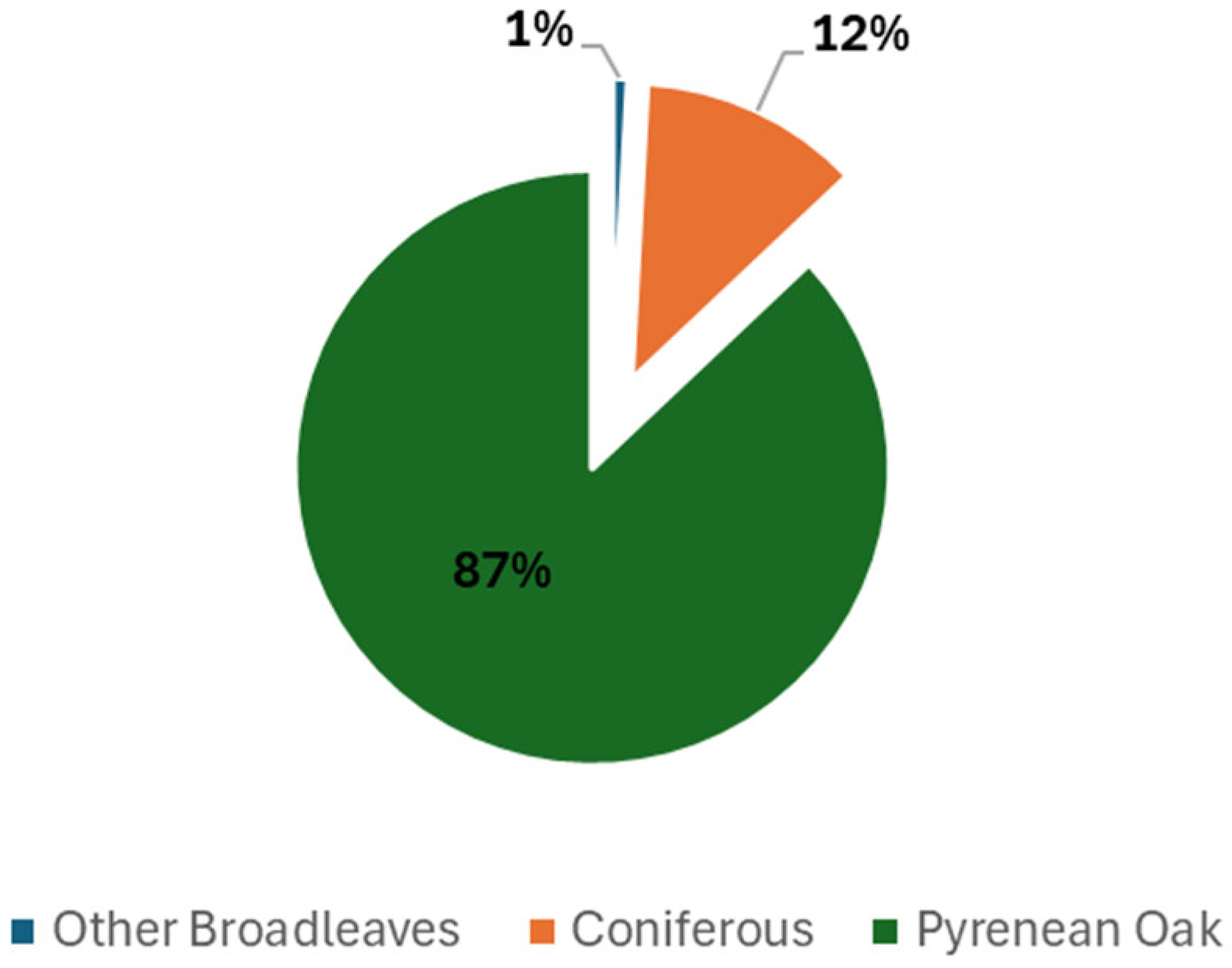
The tree species composition of QF’s forest in the last forest inventory report (2021) is mostly composed of the broadleaf Pyrenean oak (87%) and, with much lower significance, coniferous Maritime pine and Cupressus (12%) and residual fractions of other broadleaves such as Ash, Willow, and Eucalyptus (Figure 19).
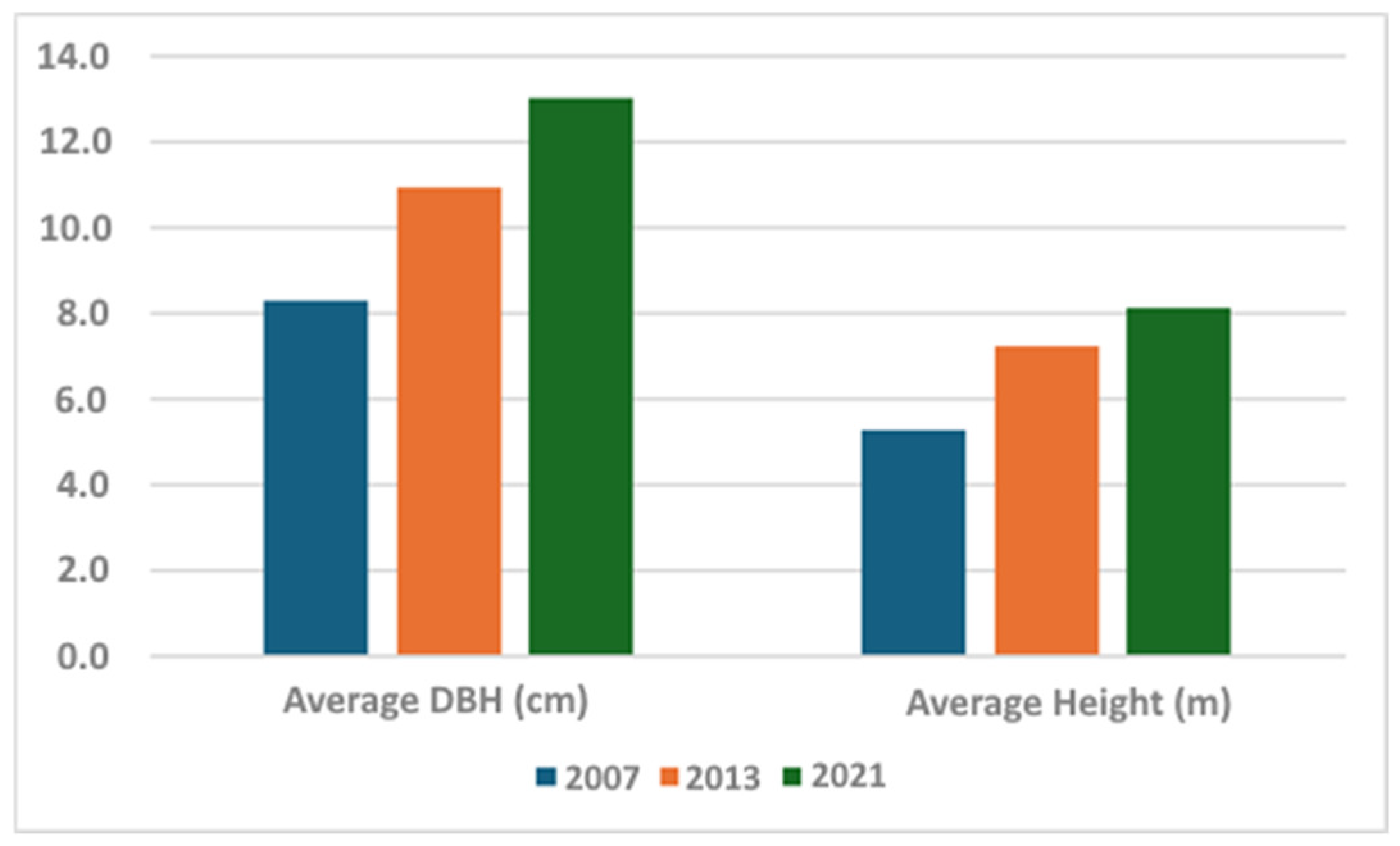
Diameter at breast height (DBH) and tree height (H) are key indicators of forest maturity and health in Quercus pyrenaica (Pyrenean oak) stands, with studies in Portugal and Spain having shown that higher DBH values are associated with more advanced forest structure, higher biomass accumulation, and greater carbon storage [106,107,108].
Figure 20 shows that, over approximately fifteen years of forest management at QF, the average DBH and H increased by almost 50%.
The literature indicates that mature Quercus pyrenaica forests with higher biomass values have structural characteristics that confer greater stability and resilience. In addition, accumulated biomass is directly related to stand maturity [109].

4.2. Grazing

Regarding tree density and tree biomass, Figure 21 indicates that there has been a general increase along the years for both areas (southern area—grazed; northern area—non-grazed), with approximately 26% more (101 trees per hectare) in 2021, compared to 2007. When looking into the tree density simple average growth per year, since grazing was introduced (2018), in the grazed area, it is much larger than in the non-grazed area, i.e., 7.0% (grazed area) vs. 1.4% (non-grazed area).
The results show that in 2007 and 2013, the southern area, which at the time, was not grazed, had lower tree density when compared with the northern area, but with the same tree biomass (hence, higher average biomass per tree) (Figure 21). After the introduction of grazing in 2018, there was an observable effect in 2021, with a higher increasing number of trees in the grazed area and higher biomass. This finding may be indicative that cattle do not hinder natural tree regeneration nor negatively affect fully mature trees.
Field monitoring results (Figure 22) demonstrate the effects of cattle grazing and trampling on vegetation structure. These effects indicate distinct vegetation trajectories between the grazed and ungrazed areas. In the ungrazed area, vegetation evolved towards a denser structure, with an increase in vertical continuity due to greater coverage across multiple strata. In particular, there was an accumulation of herbaceous biomass in the lower layers (<0.5 m), along with an increase in tall grasses and shrubs in the intermediate and upper strata (0.5–2 m), contributing to vertical fuel connectivity and potentially increasing susceptibility to fire spread.
In contrast, the grazed area exhibited more constrained vegetation growth and a more discontinuous vertical structure. Vegetation cover in the intermediate strata declined, likely reflecting reduced recruitment of oak saplings and a thinning of lower tree branches due to browsing (<2 m). There was also a decrease in the cover of tall grasses. Regarding shrub cover, the animals showed more constrained effects, as it increased slightly over time. At the ground level (<0.25 m), herbaceous cover increased, yet a higher proportion of bare soil was observed, compared to the ungrazed parcel, potentially indicating localised soil disturbance associated with cattle presence.
Additionally, fieldwork results suggest that, although cattle grazing does not prevent shrub growth in grazed areas, shrub biomass in these areas accumulated at a slower rate compared to non-grazed areas [94]. This effect could also be detected in the shrub cover map (Figure 14), pointing to a higher fraction in the non-grazed area with higher shrub cover percentage class (>50%–100%) when compared to the grazed area (>0% to 50% cover) [99].
The analysis of remotely sensed data [48] also indicates an increase in herbaceous vegetation productivity in the grazed areas at the start of the autumn growing season, as well as higher annual peak productivity, in the early spring. Additionally, a decline in shrub peak productivity was observed in grazed areas, though without changes in phenology patterns.
The mechanical impact of cattle, including trampling and grazing, contributes to reducing both horizontal and vertical biomass continuity, creating gaps that are critical for reducing local fire hazard [90]. This activity helps maintain forest clearings and pathways, contributing to a diverse landscape mosaic that enhances fire prevention. Furthermore, grazing plays a vital role in the forest soil nutrient cycle through the addition of organic matter, acting as a natural fertiliser [110]. Grazing activity supports biodiversity and fosters phytosociological synergies between native grasses, shrubs, and trees [111,112]. These contributions are particularly relevant for forest management and restoration efforts (Figure 23).

4.3. Prescribed Fire

In order to assess the impact of the prescribed fire event on the reduction in understory biomass, the prescribed fire area was compared to a control area, where there was no fire (Figure 24).
The two monitored areas had a similar land cover structure, prior to the prescribed fire event, and analogous topographical terrain characteristics (assessed with the high-resolution land cover map, and digital elevation model—4 cm × 4 cm—obtained through UAV imagery and orthophoto map classification). The land cover structure is composed of a minor percentage of rocky and bare ground, less than 5% coverage, approximately 10% of annual grasses, around 20% of shrub, mostly composed of White Broom (Cytisus multiflorus), Blackberry (Rubus spp.), and Ferns (Pteridium aquilinum), and the largest area is covered by a mature mix of trees of deciduous Pyrenean Oak (Quercus pyrenaica) and coniferous Maritime Pine trees (Pinus pinaster), covering more than 65% of the area (Table 2).
We emphasise that the land cover map results from a horizontal classification of the orthophoto map and does not consider grasses and shrubs in the trees’ understory.
On the prescribed burning test day, meteorological conditions and terrain characteristics at the site were checked by the present prescribe burning experts to fit the burning protocol conditions (against the wind and downhill) at the start and during the burning event, which occurred from 12:00 to 17:00, local time (UTC + 0). Average atmospheric measurements indicated an air temperature of 15 °C, 60% air humidity, and a low wind speed of 0.5 km/h from the southeast quadrant. These conditions were observed via equipment from the prescribed burning technicians and recorded at the local IoT-enabled weather station, integrated into the QF’s monitoring infrastructure.
The topography of the prescribed burning area is characterised by a gentle slope averaging 4%, situated at an elevation of 460 m above sea level. The predominant hill aspect is oriented toward the southeast. These terrain features were derived from a high-resolution digital elevation model (DEM), generated through drone-based sensing as part of the QF’s agroforestry technological framework.
Despite QF’s forest being systematically subjected to local data collection, including regular vegetation surveys and forest inventories (as described above), no in situ data was available covering specifically the period and location where the prescribed fire was carried out. This is explained, first, by the fact only one single burning event was carried out, and in a small test area, and second, by the fact that, given the intervention date (January 2024), only one full period of vegetation growth was available. These limitations were overcome by using remote sensing data collection with longer time series of Sentinel-2 imagery repository and its derived NDVI products, alongside data from drone flights and land cover classification products. The used combination of NDVI monthly data (during one year before and after the event) with the land cover classification, at the monitored areas (control area and prescribed fire area), presented a proxy suitable solution for biomass assessment in the absence of available in situ data. The rationale for this approach is that NDVI is a recognised index for vegetation condition assessment, making it possible to compare two similar areas in terms of land cover and terrain characteristics, the only difference being the understory fuel management, one with prescribed burning versus one with non-intervention. Thus, the aim was not to assess the direct effect on the biomass volume, but rather to infer the effect on the vegetation vigour pre- and post-fire situation, and in the different land cover classes (trees, shrubs, and grasses) and, thereby, to possibly relate with the prescribed burning event.
The effect of the prescribed fire was evaluated by comparing the NDVI ratio for the land cover biomass classes before and after the burning event in two monitored areas. The NDVI was assessed with a raster spatial zone statistics tool (QGIS—Zonal Statistics, https://qgis.org/, accessed on 15 May 2025) at a resolution of 10 × 10 m applied over the land cover vector map for a total of 22 Sentinel-2 images, with dates in 2023 and 2024 (Table 3). One cloudless image was used per month (for December 2023 and March 2024, it was not possible to obtained clear sky images—NDVI values for these two months were calculated by linear interpolation). Note that in the oak-covered areas, the satellite receives reflected light from under the canopy for half of the year, since these oaks are deciduous, without leaves from mid-autumn until mid-spring.
Figure 25 presents the evolution of NDVI for 2023 and 2024, i.e., before and after the prescribed fire event at Quinta da França (30/01/2024), for each control area and prescribed fire area (below, we analyse each vegetation stratum separately). Figure 25 shows that the control area was adequately chosen: the two NDVI curves are quite similar until the prescribed fire and then start to differ. Also, right after the prescribed fire event, in the beginning of 2024 and the starting of the vegetation resurgence season, the NDVI signature curves seems to capture the greenness of the vegetation growth signal, but more intensely in the prescribed fire area, when compared to the controlled area. This NDVI signature curve inverts their position in the second half of spring season and in the summer for both the prescribed fire area and controlled area but with lower vegetation signal vigour in the former. Since during summer, there is no grass and the trees are the same from 2023 to 2024, the NDVI decrease in the prescribed fire area seems to indicate a reduction in shrubs.
Table 4 shows the analysis of the NDVI ratio (NDVI in the prescribed fire area divided by NDVI in the control area) for each landcover stratum in the summer period, when the grasses have dried out, but the shrubs and trees have not. Comparing the summers of 2023 and 2024, we see a significant reduction in the grasses and shrubs, with no significant change in the trees.

5. Conclusions

In the scope of the SILVANUS European project and based on Terraprima’s expertise and experience, Quinta da França (QF) has been working on the implementation of integrated forest management and closer-to-nature forest management through a sustainable agro-silvo-pastural holistic management approach involving modern technology for data monitoring and data collection for the decision-making process. By developing a mixed oak-dominated forest ecosystem with a complex mosaic, including coniferous tree, shrubland, and pastures, it has promoted ecological processes that are expected to lead to a more resilient forestry ecosystem, promoting biodiversity conservation, soil protection, water cycle regulation, carbon sequestration, climate adaptation, and livestock production. Quantitative evaluation of the interventions has shown that prescribed fire leads to decreased fuel loading and that grazing leads to decreased horizontal and vertical vegetation continuity, reducing fire risk and increasing biomass, and hence carbon sequestration.
The main findings from QF’s case study suggest potential benefits from integrating CTNFM, particularly through the combination of grazing, prescribed burning, and long-term active silvo-pastoral active practices for managing forest understory biomass, as part of an IFM holistic approach to wildfire resilience. The structural maturity now observed in QF’s Pyrenean oak forest contributes to its enhanced stability and resilience to environmental disturbances. The use of cattle free-grazing contributes to the regulation of understory vegetation growth and to a more discontinuous vertical structure, with breaks that can help prevent the development of ladder fuels. It does not appear to affect fully mature trees, tree density, or natural regeneration, and its impact is more evident in the intermediate shrub strata and tall grasses. Additionally, for non-grazed areas, the prescribed underburning intervention seems to be a promising solution for understory fuel load control, in terms of its effect on the grasses’ and shrubs’ NDVI vigour after the burn in the next vegetation growing seasons, apparently not harming the topsoil mulch and mature trees.
This paper reinforces the importance of conserving and promoting mature Quercus pyrenaica forests, not only for their capacity to store biomass and promote ecosystem services such as carbon sequestration, soil protection from erosion processes, water cycle regulation, air quality, natural quality scenic, and landscape attributes but also for multiple other socio-economic services, namely agroforestry uses, with natural pastures for extensive grazing, and societal forest recreational/tourism uses. Finally, their contribution to fostering the stability and resilience of Mediterranean forest ecosystems in the face of challenges posed by desertification and forest fires is also instrumental.
The integrated fire management (IFM) approach is characterised in the literature as a holistic, multi-disciplinary strategy that synthesises scientific research, operational tactics, and socio-economic considerations to address the challenges posed by wildfires [15,18]. This approach moves beyond traditional fire suppression methods by incorporating all the phases of disaster management cycle, i.e., Phase A—prevention and preparedness, Phase B—detection and response, and Phase C—restoration and adaptation within a unified framework. The key to the IFM approach is the recognition that wildfires are complex socio-ecological phenomena influenced by natural processes and human activities. As such, effective management requires the integration of diverse data sources—such as historical fire records, remote sensing information, and climate projections—with on-the-ground ecological assessments and local knowledge. This synthesis allows for the development of predictive models that not only forecast fire behaviour but also assess vulnerabilities across different landscapes and communities. Furthermore, the IFM approach emphasises the importance of collaborative governance. It calls for the active involvement of multiple stakeholders, including government agencies, local communities, scientists, and land managers. By fostering partnerships and leveraging a broad range of expertise, this approach aims to enhance decision-making processes, promote adaptive management practices, and ensure that fire management strategies are both contextually relevant and sustainable over the long term. In essence, the literature underscores that an integrated fire management approach is essential for mitigating wildfire risks in an era of changing climate and land-use patterns. It seems to offer a pathway to balance ecological integrity, community resilience, and economic stability, thereby paving the way for more effective and comprehensive wildfire management strategies. In the literature, a framework for wildfire risk assessment has been published [111,112].
The IFM framework has been implemented by the SILVANUS project, integrating multiple components to support both risk evaluation and the development of risk reduction and adaptation strategies. The framework is structured to amalgamate diverse data inputs—such as fire behaviour metrics, fuel characteristics, meteorological variables, and topographical information—into a coherent modelling system that simulates fire dynamics. These models are further augmented by vulnerability and exposure assessments, which account for ecological, social, and economic factors that modulate the overall risk profile. At its core, the conceptual scheme emphasises an iterative feedback mechanism whereby outputs from the predictive models and vulnerability analyses inform and refine risk management strategies. This dynamic loop facilitates continual improvement of the risk assessment process, ensuring that it remains adaptive to new data and evolving environmental conditions. The integration of these components not only provides a robust foundation for assessing wildfire risk but also offers a versatile platform that can be extended to guide risk reduction and adaptation measures in the face of changing wildfire regimes, extending beyond the risk assessment framework to include the components that will empower the relevant stakeholders to be able to undertake interventions to mitigate wildfires.
The QF case study demonstrates how the strategic integration of prescribed burning alongside planned grazing and carefully executed selective silvicultural treatments within a mixed oak–pine forest mosaic can reduce wildfire risk while enhancing biodiversity, soil protection, and carbon storage. This integration of ecological restoration and fire prevention within an agro-silvo-pastoral system serves as a replicable model for other regions facing similar socio-ecological challenges, such as land abandonment, rural depopulation and WUI area expansion, and fire-prone landscapes.
Moreover, the monitoring-driven decision-making process employed at QF, by leveraging modern technologies like UAVs, IoT sensors, and satellite data, illustrates the feasibility of operationalising IFM in a practical and cost-effective manner. This technological integration is particularly relevant for Portuguese forest authorities and landowners, offering a scalable framework for proactive fuel management and biodiversity-oriented forestry in vulnerable ecosystems. By aligning with national and EU strategies for climate adaptation and sustainable land use, the QF model provides concrete guidance for upscaling IFM and CTNFM across the Mediterranean basin, fostering more resilient landscapes and communities.

Author Contributions

Conceptualization, N.K. and G.S.; writing—original draft preparation, T.D., N.K., G.S., K.C. and I.G.; writing—review and editing, T.D., N.K., G.S., K.C., I.G., V.P., I.R. and M.P.; supervision, T.D., N.K. and G.S. All authors have read and agreed to the published version of the manuscript.

Funding

This research was funded by the European Union’s Horizon 2020 research and innovation programme under grant agreement No. 101037247 (SILVANUS—Integrated Technological and Information Platform for wildfire Management [SILVANUS]). Financial support for this research was provided by FCT/MCTES (PIDDAC) through projects LARSyS—FCT Pluriannual funding (UIDB/50009/2025, UIDP/50009/2025, and LAP/0083/2020), 2020.06277.BD (I. Ribeiro), and https://doi.org/10.54499/CEECIND/04469/2017/CP1461/CT0023 accessed on 15 May 2025 (V. Proença).

Data Availability Statement

The data presented in this study are not publicly available due to privacy restrictions.

Conflicts of Interest

The funders had no role in the design of this study; in the collection, analyses, or interpretation of data; in the writing of the manuscript; or in the decision to publish the results. Tiago Domingos is shareholder and CEO of Terraprima; Ivo Gama is an employee of Terraprima. The authors declare no conflict of interest.

Abbreviations

The following abbreviations are used in this manuscript:
AIArtificial Intelligence
CNNConvolutional Neural Network
CTNFMCloser-to-Nature Forest Management
DBHDiameter at Breast Height
DSSDecision Support System
EOEarth Observation
ESAEuropean Space Agency
EU European Union
FAOFood and Agriculture Organization of the United Nations
FCNNFully Convolutional Neural Network
FDIFire Danger Index
FFDNIntegrated Forest Fire Defence Network
FIForest Inventories
FMSFuel Management Strips
GHGGreenhouse Gases
GISGeographic Information System
HHeight
IFMIntegrated Fire Management
IWRMIntegrated Wildfire Risk Management
LFGLandscape Fire Governance Framework
LiDAR Light Detection and Ranging
MAEMean Absolute Error
NbSNature-Based Solution
NDVINormalised Difference Vegetation Index
NIRNear-Infrared
PPSAPriority Prevention and Security Areas
PBPrescribed Burning
PNDFCINational Plan for Forest Fire Prevention and Protection
PUBPrescribed Underburning
QFQuinta da França
QGISQuantum GIS software
R2Coefficient of Determination
ResNetResidual Network
RGBRed, Green, and Blue
RMSERoot Mean Squared Error
UAVUnmanned Aerial Vehicle
UPUser Products
UTCCoordinated Universal Time
WUIWildland–Urban Interface

References

  1. Lee, H.; Calvin, K.; Dasgupta, D.; Krinner, G.; Mukherji, A.; Thorne, P.; Park, Y. IPCC, 2023: Climate Change 2023: Synthesis Report, Summary for Policymakers. Contribution of Working Groups I, II and III to the Sixth Assessment Report of the Intergovernmental Panel on Climate Change; Core Writing Team, Lee, H., Romero, J., Eds.; IPCC: Geneva, Switzerland, 2023. [Google Scholar] [CrossRef]
  2. Kalabokidis, K.; Palaiologou, P.; Xanthopoulos, G. Pyro-geography of the Greek landscape. In The Geography of Greece: Managing Crises and Building Resilience; Springer International Publishing: Cham, Switzerland, 2024; pp. 373–387. [Google Scholar] [CrossRef]
  3. Knutzen, F.; Averbeck, P.; Barrasso, C.; Bouwer, L.M.; Gardiner, B.; Grünzweig, J.M.; Hänel, S.; Haustein, K.; Johannessen, M.R.; Kollet, S.; et al. Impacts on and damage to European forests from the 2018–2022 heat and drought events. Nat. Hazards Earth Syst. Sci. 2025, 25, 77–117. [Google Scholar] [CrossRef]
  4. Heidari, H.; Arabi, M.; Warziniack, T. Effects of climate change on natural-caused fire activity in western US national forests. Atmosphere 2021, 12, 981. [Google Scholar] [CrossRef]
  5. Jones, M.W.; Abatzoglou, J.T.; Veraverbeke, S.; Andela, N.; Lasslop, G.; Forkel, M.; Smith, A.J.; Burton, C.; Betts, R.A.; van der Werf, G.R.; et al. Global and regional trends and drivers of fire under climate change. Rev. Geophys. 2022, 60, e2020RG000726. [Google Scholar] [CrossRef]
  6. Silva, P.; Carmo, M.; Rio, J.; Novo, I. Changes in the Seasonality of Fire Activity and Fire Weather in Portugal: Is the Wildfire Season Really Longer? Meteorology 2023, 2, 74–86. [Google Scholar] [CrossRef]
  7. Tedim, F.; Xanthopoulos, G.; Leone, V. Forest fires in Europe: Facts and challenges. In Wildfire Hazards, Risks and Disasters; Elsevier: Amsterdam, The Netherlands, 2015; pp. 77–99. [Google Scholar]
  8. Bar-Massada, A.; Alcasena, F.; Schug, F.; Radeloff, V.C. The wildland–urban interface in Europe: Spatial patterns and associations with socioeconomic and demographic variables. Landsc. Urban Plan. 2023, 235, 104759. [Google Scholar] [CrossRef]
  9. Aksoy, E.; Kocer, A.; Yilmaz, İ.; Akçal, A.N.; Akpinar, K. Assessing fire risk in wildland–urban interface regions using a machine learning method and GIS data: The example of Istanbul’s European Side. Fire 2023, 6, 408. [Google Scholar] [CrossRef]
  10. Taccaliti, F.; Marzano, R.; Bell, T.L.; Lingua, E. Wildland–urban interface: Definition and physical fire risk mitigation measures, a systematic review. Fire 2023, 6, 343. [Google Scholar] [CrossRef]
  11. Kreider, M.R.; Higuera, P.E.; Parks, S.A.; Rice, W.L.; White, N.; Larson, A.J. Fire suppression makes wildfires more severe and accentuates impacts of climate change and fuel accumulation. Nat. Commun. 2024, 15, 2412. [Google Scholar] [CrossRef] [PubMed]
  12. Wu, X.; Sverdrup, E.; Mastrandrea, M.D.; Wara, M.W.; Wager, S. Low-intensity fires mitigate the risk of high-intensity wildfires in California’s forests. Sci. Adv. 2023, 9, eadi4123. [Google Scholar] [CrossRef]
  13. Pronto, L.; Part-Guitart, N.; Caamano, J.; Alfonso, L.; Almodovar, J.; Molina, N.L.; Vendrell, J. Forest Fires of Summer 2022: Lessons to Draw from the Cohesion Policy Response; IPOL|Policy Department for Structural and Cohesion Policies: Brussels, Belgium, 2023. [Google Scholar] [CrossRef]
  14. Moore, P.F. Global wildland fire management research needs. Curr. For. Rep. 2019, 5, 210–225. [Google Scholar] [CrossRef]
  15. Food and Agriculture Organization of the United Nations. Global Fire Management Hub. 2024. Available online: https://www.fao.org/forestry/firemanagement/projects/project-detail/global-fire-management-hub/en (accessed on 9 July 2024).
  16. Rego, F.C.; Morgan, P.; Fernandes, P.; Hoffman, C. Fire Science: From Chemistry to Landscape Management; Springer: Berlin/Heidelberg, Germany, 2021. [Google Scholar] [CrossRef]
  17. Rego, F.; Fernandes, P.; Rigolot, E. Towards Integrated Fire Management: Outcomes of the European Project Fire Paradox; No. 23; Silva, J.S., Ed.; European Forest Institute: Joensuu, Finland, 2010; pp. 35–112. [Google Scholar]
  18. Myers, R.L. Living with Fire: Sustaining Ecosystems & Livelihoods Through Integrated Fire Management; The Nature Conservancy, Global Fire Initiative: Arlington, VA, USA, 2006; Available online: https://www.cbd.int/doc/pa/tools/Living%20with%20Fire.pdf (accessed on 15 May 2025).
  19. Kalapodis, N.; Sakkas, G. Integrated fire management and closer to nature forest management at the landscape scale as a holistic approach to foster forest resilience to wildfires. Open Res. Eur. 2025, 4, 131. [Google Scholar] [CrossRef]
  20. European Commission. New EU Forest Strategy for 2030; COM(2021) 572 Final; European Commission: Brussels, Belgium, 2021; Available online: https://eur-lex.europa.eu/legal-content/EN/TXT/?uri=CELEX%3A52021DC0572 (accessed on 15 May 2025).
  21. European Commission. The European Green Deal; COM(2019) 640 Final; European Commission: Brussels, Belgium, 2019; Available online: https://eur-lex.europa.eu/legal-content/EN/TXT/?uri=CELEX:52019DC0640 (accessed on 15 May 2025).
  22. Casartelli, V.; Mysiak, J. Union Civil Protection Mechanism—Peer Review Programme for Disaster Risk Management: Wildfire Peer Review Assessment Framework (Wildfire PRAF); European Union: Brussels, Belgium, 2023; Available online: https://civil-protection-humanitarian-aid.ec.europa.eu/document/download/d61050aa-9716-471b-8579-09df502fbef4_en?filename=Wildfire_PRAF_V2.pdf (accessed on 15 May 2025).
  23. AGIF—Agência para a Gestão Integrada do Fogo Rural. Landscape Fire Governance Framework. 2023. Available online: https://www.wildfire2023.pt/conference/framework (accessed on 2 May 2025).
  24. Stoof, C.R.; Valkó, O.; Aakala, T.; Arca, B.; Arsava, K.S.; Ascoli, D.; Bengtsson, J.; Engelbrecht, J.; Fra Paleo, U.; Marinšek, A.; et al. Changing Wildfires: Policy Options for a Fire-Literate and Fire-Adapted Europe; (EASAC Policy Report); EASAC Secretariat c/o Austrian Academy of Sciences: Vienna, Austria, 2025; Available online: https://easac.eu/publications/details/changing-wildfires (accessed on 15 May 2025).
  25. European Commission, Directorate-General for Environment. Guidelines on Closer-to-Nature Forest Management; SWD(2023) 284 Final; Publications Office of the European Union: Luxembourg, 2023; Available online: https://environment.ec.europa.eu/publications/guidelines-closer-nature-forest-management_en (accessed on 15 May 2025).
  26. Larsen, J.B.; Angelstam, P.; Bauhus, J.; Carvalho, J.F.; Diaci, J.; Dobrowolska, D.; Gazda, A.; Gustafsson, L.; Krumm, F.; Knoke, T.; et al. Closer-to-Nature Forest Management. From Science to Policy 12; European Forest Institute: Joensuu, Finland, 2022; Volume 12, pp. 1–54. [Google Scholar] [CrossRef]
  27. Carey, H.; Schuman, M. Modifying Wildfire Behavior—The Effectiveness of Fuel Treatments: The Status of Our Knowledge; National Community Forestry Center, Southwest Region Working Paper No. 2; National Community Forestry Center: Parramatta, NSW, Australia, 2003; Available online: https://energyjustice.net/biomass/library/Carey-Schumann.pdf (accessed on 15 May 2025).
  28. Graham, R.T.; McCaffrey, S.; Jain, T.B. Science Basis for Changing Forest Structure to Modify Wildfire Behavior and Severity; Gen. Tech. Rep. RMRS-GTR-120; U.S. Department of Agriculture, Forest Service, Rocky Mountain Research Station: Fort Collins, CO, USA, 2004; 43p. Available online: https://research.fs.usda.gov/treesearch/6279 (accessed on 15 May 2025).
  29. Piqué, M.; Castellnou, M.; Valor, T.; Pagés, J.; Larrañaga, A.; Miralles, M.; Cervera, T. Integració del Risc de Grans Incendis Forestals (GIF) en la Gestió Forestal: Incendis Tipus i Vulnerabilitat de les Estructures Forestals al foc de Capçades; Sèrie: Orientacions de Gestió Forestal Sostenible per a Catalunya—ORGEST, No. 118; Centre de la Propietat Forestal, Departament d’Agricultura, Ramaderia, Pesca, Alimentació i Medi Natural, Generalitat de Catalunya: Barcelona, Spain, 2011. [Google Scholar]
  30. Piqué, M.; Valor, T.; Beltrán, M. Reducing vulnerability to wildfires at forest stand level. In Operational Tools and Guidelines for Improving Efficiency in Wildfire Risk Reduction in EU Landscapes; CTFC ed.; Plana, E., Font, M., Green, T., Eds.; FIREfficient Project; CTFC Editions (Forest Sciences Centre of Catalonia): Solsona, Spain, 2015; p. 88. [Google Scholar]
  31. Kalapodis, N.; Sakkas, G.; Lazarou, A.; Casciano, D.; Demestichas, K.; Athanasiou, M.; Kaloudis, S.; Sykas, D. EU-Integrated Multifunctional Forest and Fire Management, Policies, and Practices: Challenges Between “As-Is” and “To-Be” State. In Paradigms on Technology Development for Security Practitioners; Springer Nature Switzerland: Cham, Switzerland, 2024; pp. 65–77. [Google Scholar] [CrossRef]
  32. Kalapodis, N.G. Reorientação da Gestão Florestal na Grécia com Relação à Gestão Florestal Multifuncional, Orientada para a Natureza e Ambientalmente Adaptável. Ph.D. Thesis, Albert-Ludwigs-University Freiburg, Breisgau, Germany, 2010. [Google Scholar]
  33. Kalapodis, N.G. Close to nature forestry in order to reduce the risk of natural disasters. In Proceedings of the 14th Hellenic Forestry Congress, Patra, Greece, 4–7 October 2009. [Google Scholar]
  34. Mairota, P.; Manetti, M.C.; Amorini, E.; Pelleri, F.; Terradura, M.; Frattegiani, M.; Savini, P.; Grohmann, F.; Mori, P.; Terzuolo, P.; et al. Opportunities for coppice management at the landscape level: The Italian experience. IFOREST 2016, 9, 775–782. [Google Scholar] [CrossRef]
  35. Brang, P.; Spathelf, P.; Larsen, J.B.; Bauhus, J.; Boncčìna, A.; Chauvin, C.; Drössler, L.; García-Güemes, C.; Heiri, C.; Kerr, G.; et al. Suitability of close-to-nature silviculture for adapting temperate European forests to climate change. For. Int. J. For. Res. 2014, 87, 492–503. [Google Scholar] [CrossRef]
  36. Schütz, J.P. Der Plenterwald und Weitere Formen Strukturierter und Gemischter Wälder; Parey Verlag: Berlin, Germany, 2001; 207p. [Google Scholar]
  37. Silva, J.S.; Moreira, F.; Vaz, P.; Catry, F.; Godinho-Ferreira, P. Assessing the relative fire proneness of different forest types in Portugal. Plant Biosyst. 2009, 143, 597–608. [Google Scholar] [CrossRef]
  38. González, J.R.; Pukkala, T. Characterization of forest fires in Catalonia (north-east Spain). Eur. J. For. Res. 2007, 126, 421–429. [Google Scholar] [CrossRef]
  39. Hély, C.; Bergeron, Y.; Flannigan, M.D. Effects of stand composition on fire hazard in mixed-wood Canadian boreal forest. J. Veg. Sci. 2000, 11, 813–824. [Google Scholar] [CrossRef]
  40. Corona, P.; Ascoli, D.; Barbati, A.; Bovio, G.; Colangelo, G.; Elia, M.; Garfì, V.; Iovino, F.; Lafortezza, R.; Leone, V.; et al. Integrated forest management to prevent wildfires under Mediterranean environments. Ann. Silvic. Res. 2015, 39, 1–22. [Google Scholar]
  41. Neidermeier, A.N.; Zagaria, C.; Pampanoni, V.; West, T.A.P.; Verburg, P.H. Mapping opportunities for the use of land management strategies to address fire risk in Europe. J. Environ. Manag. 2023, 346, 118941. [Google Scholar] [CrossRef]
  42. North, M.; Hurteau, M.; Innes, J. Fire suppression and fuels treatment effects on mixed-conifer carbon stocks and emissions. Ecol. Appl. 2009, 19, 1385–1396. [Google Scholar] [CrossRef]
  43. Foster, D.E.; Battles, J.J.; Collins, B.M.; York, R.A.; Stephens, S.L. Potential wildfire and carbon stability in frequent-fire forests in the Sierra Nevada: Trade-offs from a long-term study. Ecosphere 2020, 11, e03198. [Google Scholar] [CrossRef]
  44. California Department of Forestry and Fire Protection [CAL FIRE]. Fuel Reduction. 2022. Available online: https://www.fire.ca.gov/what-we-do/natural-resource-management/fuels-reduction (accessed on 6 June 2025).
  45. Catry, F.X.; Pausas, J.G.; Moreira, F.; Fernandes, P.M.; Rego, F. Post-fire response variability in Mediterranean Basin tree species in Portugal. Int. J. Wildland Fire 2013, 22, 919–932. [Google Scholar] [CrossRef]
  46. Marañón, T.; Pérez-Ramos, I.M.; Villar Montero, R.; Acácio, V.; Aranda, I.; Camarero, J.J.; Valbuena-Carabaña, M. Iberian oaks coping with global change: Ecological processes and management strategies. In Quercus: Classification, Ecology and Uses; Steffensen, B.J., Ed.; Nova Science Publishers: New York, NY, USA, 2020; pp. 1–84. [Google Scholar]
  47. Dimitrakopoulos, A.P.; Papaioannou, K.K. Flammability assessment of Mediterranean forest fuels. Fire Technol. 2001, 37, 143–152. [Google Scholar] [CrossRef]
  48. Balata, D.; Gama, I.; Domingos, T.; Proença, V. Using satellite NDVI time-series to monitor grazing effects on vegetation productivity and phenology in heterogeneous Mediterranean forests. Remote Sens. 2022, 14, 2322. [Google Scholar] [CrossRef]
  49. Sykas, D.; Zografakis, D.; Demestichas, K.; Costopoulou, C.; Kosmidis, P. EO4WildFires: An Earth observation multi-sensor, time-series machine-learning-ready benchmark dataset for wildfire impact prediction (1.0) [Data set]. In Proceedings of the Ninth International Conference on Remote Sensing and Geoinformation of Environment (RSCy2023), Ayia Nap, Cyprus, 3–5 April 2023. [Google Scholar] [CrossRef]
  50. Markarian, G.; Sakkas, G.; Kalapodis, N.; Chandramouli, K.; Marić, L. Utilisation of unmanned aerial vehicles and mesh in the sky wireless communication system in wildfire management. In Proceedings of the 2024 IEEE International Geoscience and Remote Sensing Symposium (IGARSS), Athens, Greece, 7–12 July 2024; pp. 2077–2081. [Google Scholar] [CrossRef]
  51. Zelenka, J.; Kasanicky, T.; Gatial, E.; Balogh, Z.; Majlingova, A.; Brodrechtova, Y.; Rehák, R.; Semet, Y.; Boussu, G. Coordination of drones swarm for wildfires monitoring. In Proceedings of the 20th Annual Global Conference on Information Systems for Crisis Response and Management (ISCRAM 2023), Omaha, NE, USA, 28–31 May 2023. [Google Scholar]
  52. Laksito, A.D.; Kusrini, K.; Setyanto, A.; Johari, M.Z.F.; Maruf, Z.R.; Yuana, K.A.; Adninda, G.B.; Kartikakirana, R.A.; Nucifera, F.; Widayani, W.; et al. Machine learning and social media harvesting for wildfire prevention. In Proceedings of the 2023 IEEE 13th International Conference on Pattern Recognition Systems (ICPRS), Guayaquil, Ecuador, 4–7 July 2023; pp. 1–6. [Google Scholar] [CrossRef]
  53. Balogh, Z.; Gatial, E.; Dolatabadi, S.H.; Dlugolinský, Š.; Saltarella, M.; Scipioni, M.P.; Grunwald, D.; Przybyszewski, M.; Majlingova, A.; Majlingova, Y.; et al. Communication Protocol for using Nontraditional Information Sources between First Responders and Citizens during Wildfires. In Proceedings of the 20th International ISCRAM Conference, Omaha, NE, USA, 28–31 May 2023; pp. 152–165. Available online: https://idl.iscram.org/files/balogh/2023/2514_Balogh_etal2023.pdf (accessed on 15 May 2025).
  54. Yuana, K.A.; Setyanto, A.; Laksito, A.D.; Maruf, Z.R.; Johari, M.Z.F.; Adninda, G.B.; Kartikakirana, R.A.; Suprapto, R.A.; Mimboro, P.; Widayani, W. Monte Carlo method for map area calculation in wildland fire map management. In Proceedings of the 2022 6th International Conference on Information Technology, Information Systems and Electrical Engineering (ICITISEE), Yogyakarta, Indonesia, 13–14 December 2022; pp. 14–17. [Google Scholar] [CrossRef]
  55. Yuana, K.A.; Kusrini, K.; Setyanto, A.; Laksito, A.D.; Maruf, Z.R.; Johari, M.Z.F.; Adninda, G.B.; Kartikakirana, R.A.; Suprapto, R.A.; Mimboro, P.; et al. GIS data support technique for forest fire management and decision support system: A Sebangau National Park, Kalimantan case. In Proceedings of the 2023 6th International Conference on Information and Communications Technology (ICOIACT), Yogyakarta, Indonesia, 10 November 2023; pp. 286–291. [Google Scholar] [CrossRef]
  56. Grant, M.A.; Duff, T.J.; Penman, T.D.; Pickering, B.J.; Cawson, J.G. Mechanical mastication reduces fuel structure and modelled fire behaviour in Australian shrub encroached ecosystems. Forests 2021, 12, 812. [Google Scholar] [CrossRef]
  57. Cawson, J.G.; Duff, T.J.; Penman, T.D. Long-term response of fuel to mechanical mastication in south-eastern Australia. Fire 2022, 5, 76. [Google Scholar] [CrossRef]
  58. Dell, J.R.; Ward, F.R. Reducing Fire Hazard in Ponderosa Pine Thinning Slash by Mechanical Crushing. U.S. Forest Service, PSW-RP-57. 1969. Available online: https://research.fs.usda.gov/treesearch/28631 (accessed on 15 May 2025).
  59. Volkova, L.; Weston, C.J. Effect of thinning and burning fuel reduction treatments on forest carbon and bushfire fuel hazard in Eucalyptus sieberi forests of south-eastern Australia. Sci. Total Environ. 2019, 694, 133708. Available online: https://pubmed.ncbi.nlm.nih.gov/31398652/ (accessed on 15 May 2025). [CrossRef] [PubMed]
  60. Fernandes, P.M.; Botelho, H.S. Effectiveness of mechanical thinning and prescribed burning on fire behavior in Pinus nigra forests in NE Spain. For. Ecol. Manag. 2017, 406, 1–8. Available online: https://pubmed.ncbi.nlm.nih.gov/29111258/ (accessed on 15 May 2025).
  61. Lasanta, T.; Khorchani, M.; Pérez-Cabello, F.; Errea, P.; Sáenz-Blanco, R.; Nadal-Romero, E. Clearing shrubland and extensive livestock farming: Active prevention to control wildfires in the Mediterranean mountains. J. Environ. Manag. 2018, 227, 256–266. [Google Scholar] [CrossRef] [PubMed]
  62. Pádua, L.; Castro, J.P.; Castro, J.; Sousa, J.J.; Castro, M. Assessing the Impact of Clearing and Grazing on Fuel Management in a Mediterranean Oak Forest through Unmanned Aerial Vehicle Multispectral Data. Drones 2024, 8, 364. [Google Scholar] [CrossRef]
  63. Brodie, E.G.; Knapp, E.E.; Brooks, W.R.; Drury, S.A.; Ritchie, M.W. Forest thinning and prescribed burning treatments reduce wildfire severity and buffer the impacts of severe fire weather. Fire Ecol. 2024, 20, 17. [Google Scholar] [CrossRef]
  64. Vilà-Vilardell, L.; De Cáceres, M.; Piqué, M.; Casals, P. Prescribed fire after thinning increased resistance of sub-Mediterranean pine forests to drought events and wildfires. For. Ecol. Manag. 2023, 527, 120602. [Google Scholar] [CrossRef]
  65. Reiner, A.L.; Vaillant, N.M.; Fites-Kaufman, J.; Dailey, S.N. Mastication and prescribed fire impacts on fuels in a 25-year old ponderosa pine plantation, southern Sierra Nevada. For. Ecol. Manag. 2009, 258, 2365–2372. [Google Scholar] [CrossRef]
  66. Busse, M.D.; Hubbert, K.R.; Fiddler, G.O. Lethal soil heating during burning of masticated forest residues. Int. J. Wildland Fire 2009, 18, 761–776. [Google Scholar] [CrossRef]
  67. Xing, J.; Yuan, Z.; Fu, S.; Wu, D.; Li, G. Fine woody debris retention improves soil microbial carbon dynamics in urban spruce plantations. Forests 2025, 16, 434. [Google Scholar] [CrossRef]
  68. Kane, J.M.; Varner, J.M.; Hiers, J.K. The burning characteristics of masticated fuels: A laboratory study. Fire Ecol. 2009, 5, 15–29. [Google Scholar]
  69. Keesstra, S.; Lebelt, L.; Castellani, C.; Breil, M.; Akujärvi, A.; Pellens, N.; Rooij, B.; Minnen, J.; Cristiano, W.; Zimmer, D. Nature-Based Solutions to Address Forest Disturbances Under Climate Change: The Case of Fire and Pests; ETC-CA, LULUCF, Eds.; EEA: Copenhagen, Denmark, 2024; pp. 1–95. [Google Scholar]
  70. Pais, S.; Aquilué, N.; Honrado, J.P.; Fernandes, P.M.; Regos, A. Optimizing Wildfire Prevention through the Integration of Prescribed Burning into ‘Fire-Smart’Land-Use Policies. Fire 2023, 6, 457. [Google Scholar] [CrossRef]
  71. Alcasena, F.J.; Ager, A.A.; Salis, M.; Day, M.A.; Vega-Garcia, C. Optimizing prescribed fire allocation for managing fire risk in central Catalonia. Sci. Total Environ. 2018, 621, 872–885. [Google Scholar] [CrossRef] [PubMed]
  72. Hueso-González, P.; Martínez-Murillo, J.F.; Ruiz-Sinoga, J.D. Prescribed fire impacts on soil properties, overland flow and sediment transport in a Mediterranean forest: A 5 year study. Sci. Total Environ. 2018, 636, 1480–1489. [Google Scholar] [CrossRef] [PubMed]
  73. OECD. Taming Wildfires in the Context of Climate Change: The Case of Portugal; OECD Environment Policy Papers No. 37; OECD Publishing: Paris, France, 2023. [Google Scholar] [CrossRef]
  74. Fernandes, P.M. Scientific support to prescribed underburning in southern Europe: What do we know? Sci. Total Environ. 2018, 630, 340–348. [Google Scholar] [CrossRef]
  75. Catalanotti, A.E.; Rutigliano, F.A. Effects of Prescribed Burning on Soil and Vegetation. Ph.D. Thesis, University of Naples Federico II, Naples, Italy, 2009. [Google Scholar]
  76. De Oliveira, E.; Sequeira, A.; Fernandes, P.; Colaço, M. The Use of Vegetation Fire in Portugal: Historical Legislative and Normative Analysis. Environ. Hist. 2025, 31, 15–39. [Google Scholar] [CrossRef]
  77. Fernández-Guisuraga, J.M.; Fernandes, P.M. Prescribed burning mitigates the severity of subsequent wildfires in Mediterranean shrublands. Fire Ecol. 2024, 20, 4. [Google Scholar] [CrossRef]
  78. Francos, M.; Colino-Prieto, F.; Sánchez-García, C. How Mediterranean ecosystem deals with wildfire impact on soil ecosystem services and functions: A review. Land 2024, 13, 407. [Google Scholar] [CrossRef]
  79. Hesseln, H. The economics of prescribed burning: A research review. For. Sci. 2000, 46, 322–334. [Google Scholar] [CrossRef]
  80. Hunter, M.E.; Taylor, M.H. The economic value of fuel treatments: A review of the recent literature for fuel treatment planning. Forests 2022, 13, 2042. [Google Scholar] [CrossRef]
  81. Burrows, N.; McCaw, L. Prescribed burning in southwestern Australian forests. Front. Ecol. Environ. 2013, 11, 25–34. [Google Scholar] [CrossRef]
  82. Ryan, K.C.; Knapp, E.E.; Varner, J.M. Prescribed fire in North American forests and woodlands: History, current practice, and challenges. Front. Ecol. Environ. 2013, 11, e15–e24. [Google Scholar] [CrossRef]
  83. Dems, C.L.; Taylor, A.H.; Smithwick, E.A.H.; Kreye, J.K.; Kaye, M.W. Prescribed fire alters structure and composition of a mid-Atlantic oak forest up to eight years after burning. Fire Ecol. 2021, 17, 10. [Google Scholar] [CrossRef]
  84. Kupfer, J.A.; Lackstrom, K.; Grego, J.M.; Dow, K.; Terando, A.J.; Hiers, J.K. Prescribed fire in longleaf pine ecosystems: Fire managers’ perspectives on priorities, constraints, and future prospects. Fire Ecol. 2022, 18, 27. [Google Scholar] [CrossRef]
  85. Baeza, M.J.; De Luís, M.; Raventós, J.; Escarré, A. Factors influencing fire behaviour in shrublands of different stand ages and the implications for using prescribed burning to reduce wildfire risk. J. Environ. Manag. 2002, 65, 199–208. [Google Scholar] [CrossRef] [PubMed]
  86. Oikonomou, D.; Vrahnakis, M.; Yiakoulaki, M.; Xanthopoulos, G.; Kazoglou, Y. Grazing as a management tool in Mediterranean Pastures: A meta-analysis based on a literature review. Land 2023, 12, 1290. [Google Scholar] [CrossRef]
  87. Schaffhauser, A.; Curt, T.; Vela, E.; Tatoni, T. Recurrent fires and environment shape the vegetation in Quercus suber L. woodlands and maquis. C. R. Biol. 2012, 335, 424–434. [Google Scholar] [CrossRef]
  88. Calvo, L.; Tarrega, R.; Luis, E. Regeneration in Quercus pyrenaica ecosystems after surface fires. Int. J. Wildland Fire 1991, 1, 205–210. [Google Scholar] [CrossRef]
  89. Ribeiro, I.; Domingos, T.; McCracken, D.; Proença, V. Evaluating domestic herbivores for vegetation structure management in transitional woodland–shrubland systems. Forests 2024, 15, 2258. [Google Scholar] [CrossRef]
  90. Moreira, F.; Pe’er, G. Agricultural policy can reduce wildfires. Science 2018, 359, 1001. [Google Scholar] [CrossRef] [PubMed]
  91. Rouet-Leduc, J.; Pe’er, G.; Moreira, F.; Bonn, A.; Helmer, W.; Shahsavan Zadeh, S.A.; Zizka, A.; van der Plas, F. Effects of large herbivores on fire regimes and wildfire mitigation. J. Appl. Ecol. 2021, 58, 2690–2702. [Google Scholar] [CrossRef]
  92. Ribeiro, I.; Domingos, T.; McCracken, D.; Proença, V. The use of domestic herbivores for ecosystem management in Mediterranean landscapes. Glob. Ecol. Conserv. 2023, 46, e02577. [Google Scholar] [CrossRef]
  93. Proença, V.; Ribeiro, I.; Simões, M.; Paulo, O.; Bernardino, S.; Santos Silva, C. Implementação Custo-Eficiente de Mosaicos Silvopastoris de Carvalho Negral—Relatório Não Técnico [in Portuguese]. Terraprima, UNAC, FCUL, MARETEC/IST. 2022. Available online: https://www.terraprima.pt/pt/projecto/23 (accessed on 15 May 2025).
  94. Trencanová, B.; Proença, V.; Bernardino, A. Development of semantic maps of vegetation cover from UAV images to support planning and management in fine-grained fire-prone landscapes. Remote Sens. 2022, 14, 1262. [Google Scholar] [CrossRef]
  95. Drusch, M.; Del Bello, U.; Carlier, S.; Colin, O.; Fernandez, V.; Gascon, F.; Hoersch, B.; Isola, C.; Laberinti, P.; Martimort, P.; et al. Sentinel-2: ESA’s optical high-resolution mission for GMES operational services. Remote Sens. Environ. 2012, 120, 25–36. [Google Scholar] [CrossRef]
  96. ESA. Sentinel-2. Available online: https://www.esa.int/Applications/Observing_the_Earth/Copernicus/Sentinel-2 (accessed on 15 May 2025).
  97. Hoek van Dijke, A.J.; Mallick, K.; Teuling, A.J.; Schlerf, M.; Machwitz, M.; Hassler, S.K.; Blume, T.; Herold, M. Does the normalized difference vegetation index explain spatial and temporal variability in sap velocity in temperate forest ecosystems? Hydrol. Earth Syst. Sci. 2019, 23, 2077–2091. [Google Scholar] [CrossRef]
  98. Cherif, E.K.; Lucas, R.; Ait Tchakoucht, T.; Gama, I.; Ribeiro, I.; Domingos, T.; Proença, V. Predicting fractional shrub cover in heterogeneous Mediterranean landscapes using machine learning and Sentinel-2 imagery. Forests 2024, 15, 1739. [Google Scholar] [CrossRef]
  99. Rouse, J.W.; Haas, R.H., Jr.; Schell, J.A.; Deering, D.W. Monitoring vegetation systems in the Great Plains with ERTS. In Proceedings of the Third Earth Resources Technology Satellite-1 Symposium; NASA Goddard Space Flight Center 3d ERTS-1 Symp.; NASA: Washington, DC, USA, 1974; Volume 1, Sect. A. Available online: https://ntrs.nasa.gov/api/citations/19740022614/downloads/19740022614.pdf (accessed on 15 May 2025).
  100. Yengoh, G.T.; Dent, D.; Olsson, L.; Tengberg Compton, A.E.; Tucker, J.T., III. Use of the Normalized Difference Vegetation Index (NDVI) to Assess Land Degradation at Multiple Scales: Current Status, Future Trends, and Practical Considerations; Springer International Publishing: Berlin/Heidelberg, Germany, 2015; Available online: http://www.springer.com/series/8868 (accessed on 15 May 2025).
  101. Rezaei, R.; Ghaffarian, S. Monitoring forest resilience dynamics from very high-resolution satellite images in case of multi-hazard disaster. Remote Sens. 2021, 13, 4176. [Google Scholar] [CrossRef]
  102. Turubanova, S.; Potapov, P.; Krylov, A.; Tyukavina, A.; McCarty, J.L.; Radeloff, V.C.; Hansen, M.C. Using the Landsat data archive to assess long-term regional forest dynamics assessment in Eastern Europe, 1985–2012. ISPRS Arch. 2015, 40, 531–537. [Google Scholar] [CrossRef]
  103. Verbesselt, J.; Umlauf, N.; Hirota, M.; Holmgren, M.; Van Nes, E.H.; Herold, M.; Zeileis, A.; Scheffer, M. Remotely sensed resilience of tropical forests. Nat. Clim. Change 2016, 6, 1028–1031. [Google Scholar] [CrossRef]
  104. Renewables Grid Initiative (RGI). Implementing Integrated Vegetation Management Across Europe; Renewables Grid Initiative: Berlin, Germany, 2023; 23p. [Google Scholar]
  105. Sousa, E. Florestas Maduras: Avaliação de bosques de Quercus pyrenaica na região da Terra Fria. Master’s Thesis, Instituto Politécnico de Bragança, Bragança Portugal, December 2024. [Google Scholar]
  106. Cañellas, I.; Sánchez-González, M.; Bogino, S.M.; Adame, P.; Herrero, C.; Roig, S.; Tomé, M.; Paulo, J.A.; Bravo, F. Silviculture and carbon sequestration in Mediterranean oak forests. In Managing Forest Ecosystems: The Challenge of Climate Change; Springer: Berlin/Heidelberg, Germany, 2008; pp. 317–338. [Google Scholar] [CrossRef]
  107. Nunes, L.; Magalhães, M.; Patrício, M.S.; Luís, J.F.; Rego, F.; Lopes, D. Avaliação da produção primária líquida em povoamentos puros e mistos de Quercus pyrenaica Willd. e Pinus pinaster L. no Distrito de Vila Real. Silva Lusit. 2010, 18, 27–38. [Google Scholar]
  108. Teague, R.; Kreuter, U. Managing grazing to restore soil health, ecosystem function, and ecosystem services. Front. Sustain. Food Syst. 2020, 4, 534187. [Google Scholar] [CrossRef]
  109. Bugalho, M.N.; Lecomte, X.; Gonçalves, M.; Caldeira, M.C.; Branco, M. Establishing grazing and grazing-excluded patches increases plant and invertebrate diversity in a Mediterranean oak woodland. For. Ecol. Manag. 2011, 261, 2133–2139. [Google Scholar] [CrossRef]
  110. Wolański, P.; Bobiec, A.; Ortyl, B.; Makuch-Pietraś, I.; Czarnota, P.; Ziobro, J.; Korol, M.; Havryliuk, S.; Paderewski, J. The importance of livestock grazing at woodland-grassland interface in the conservation of rich oakwood plant communities in temperate Europe. Biodivers. Conserv. 2021, 30, 741–760. [Google Scholar] [CrossRef]
  111. Oom, D.; de Rigo, D.; Pfeiffer, H.; Branco, A.; Ferrari, D.; Grecchi, R.; Artés-Vivancos, T.; Houston Durrant, T.; Boca, R.; Maianti, P.; et al. Pan-European Wildfire Risk Assessment; Tech. Rep. No. EUR 31160 EN; Publications Office of the European Union: Luxembourg, 2022. [Google Scholar] [CrossRef]
  112. Chuvieco, E.; Yebra, M.; Martino, S.; Thonicke, K.; Gómez-Giménez, M.; San-Miguel, J.; Oom, D.; Velea, R.; Mouillot, F.; Molina, J.R.; et al. Towards an integrated approach to wildfire risk assessment: When, where, what and how may the landscapes burn. Fire 2023, 6, 215. [Google Scholar] [CrossRef]
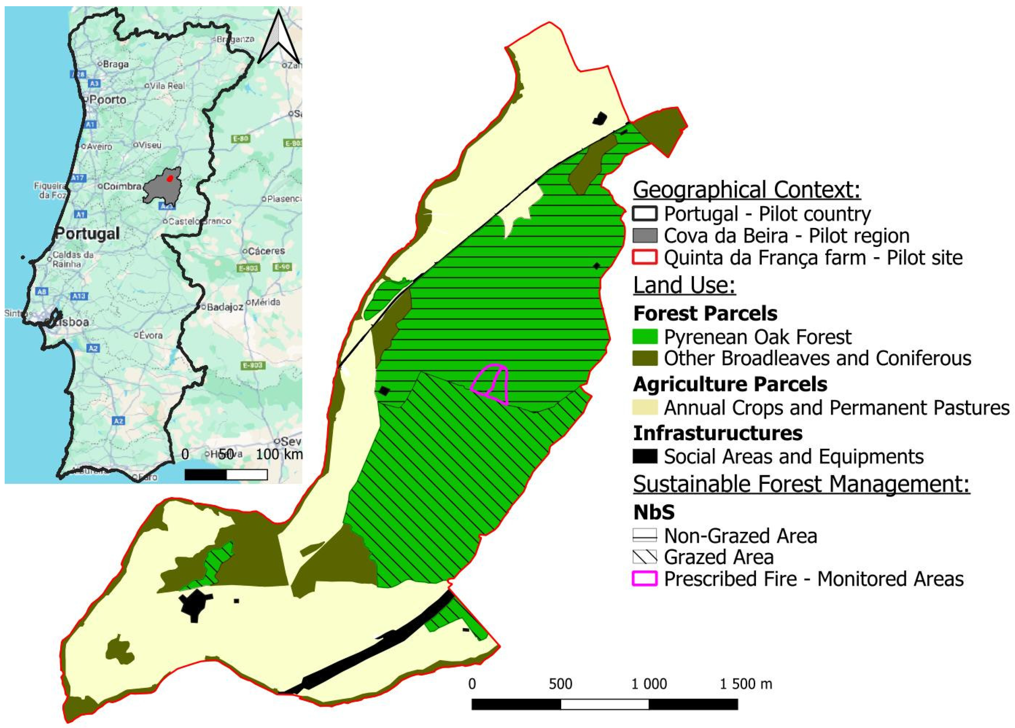
Figure 1. Quinta da França farm (pilot site), with geographical context, land use, and sustainable forest management areas.
Forests 16 01306 g001
Figure 2. SILVANUS stakeholder involvement with the relevant phases in IFM. Phase A refers to prevention and preparedness, Phase B refers to detection and response, and Phase C refers to restoration and adaptation.
Forests 16 01306 g002
Figure 3. Integrated fire management (IFM) phase clustering within an annual cycle approach in the QF pilot site. The colors in the image refers to the IFM Timeline along a annual season cycle, and are related with the forest fire hazard. From winter to summer, increase (yellow to red) and from autumn to winter decrease (red to green).
Forests 16 01306 g003
Figure 4. (Left): Firebreak network at QF. (Right): Firebreak example at QF.
Forests 16 01306 g004
Figure 5. Mechanical shrub control at QF.
Forests 16 01306 g005
Figure 6. Prescribed underburning at QF in January 2024.
Forests 16 01306 g006
Figure 7. Prescribed underburning not affecting live trees and soil organic matter. Example at QF, January 2024.
Forests 16 01306 g007
Figure 8. Prescribed underburning outcome at QF, September 2024.
Forests 16 01306 g008
Figure 9. Tree selective pruning and thinning at QF.
Forests 16 01306 g009
Figure 10. Example of a grazed area vs. non-grazed area at QF’s Pyrenean oak forest.
Forests 16 01306 g010
Figure 11. Cattle grazing in forest areas at QF.
Forests 16 01306 g011
Figure 12. Satellite (Sentinel-2) imagery data collection. Examples of composite imagery. (Left): VIS True colour; (Middle): VIS false colour; and (Right): NDVI-derived index from Sentinel-2, at QF.
Forests 16 01306 g012
Figure 13. (Left): high-resolution visible true-colour ortophotomap; (right): high-resolution land cover map, from a grazed and non-grazed area at QF.
Forests 16 01306 g013
Figure 14. (Left): high-resolution land cover map, from drone flights (4 cm × 4 cm). (Right): shrub cover map from satellite Sentinel-2 (10 m × 10 m) (adapted with permission from Ref. [99]).
Forests 16 01306 g014
Figure 15. Drone flight area for LiDAR data collection at QF.
Forests 16 01306 g015
Figure 16. (Left): LiDAR cloud points; (middle): biomass volume from LiDAR; (right): model inference from satellite image.
Forests 16 01306 g016
Figure 17. Forest inventory point grid at QF.
Forests 16 01306 g017
Figure 18. Spatial arrangement of survey plots (40 m × 40 m) at QF (left). Schematic drawing of a 40 m × 40 m survey plot, composed of four 10 m × 10 m sampling plots (right). (adapted with permission from Ref. [93].)
Forests 16 01306 g018
Figure 19. Tree fractions composition in the QF forest (FI 2021).
Forests 16 01306 g019
Figure 20. Tree average diameter at breast height (cm) and tree average height (m) along FI (2007, 2013, and 2021) at QF.
Forests 16 01306 g020
Figure 21. Tree average density (no. trees/ha) and biomass (ton/ha) along FI (2007, 2013, and 2021), for the grazed and non-grazed areas at QF.
Forests 16 01306 g021
Figure 22. Changes in the relative coverage of the vegetation life forms in different vertical strata in the monitoring areas. The cumulative coverage value can be greater than 1.
Forests 16 01306 g022
Figure 23. Forest clearing from cattle grazing at QF.
Forests 16 01306 g023
Figure 24. Monitored areas to evaluate the prescribed fire effect: (a) prescribed fire area; (b) control area (image on the left), and corresponding high-resolution land cover classes (image at the right).
Forests 16 01306 g024
Figure 25. NDVI in the monitored areas: (a) prescribed fire area; (b) control area, per month in 2023 and 2024.
Forests 16 01306 g025
Table 1. Model metrics’ values.
RMSEMAER2
0.8370.6180.537
Table 2. Land cover composition in the two monitored areas: (a) prescribed fire area; (b) control area.
(a) Prescribed Fire Area(b) Control Area
Land CoverArea (ha)%Area (ha)%
Rock0.010.50.000.3
Bare Ground0.042.70.031.7
Grass0.139.80.138.1
Shrubs0.3021.90.3521.7
Trees0.8965.11.1168.3
Total1.37100.01.62100.0
Table 3. Sentinel-2 tile number and images dates for the NDVI calculation.
Sentinel-2 Tile20232024
T29TPE4 January 202324 January 2024
3 February 20233 February 2024
15 March 202323 April 2024
19 April 202323 May 2024
14 May 202312 June 2024
23 June 202312 July 2024
13 July 202316 August 2024
12 August 202315 September 2024
26 September 20235 October 2024
1 October 20239 November 2024
25 November 20239 December 2024
Table 4. NDVI ratio (prescribed/control) in 2023 and 2024 for the summer period and its change. The delta (Δ) symbol represents the variation between years.
Land Cover20232024
Grass4.8%1.1%−3.7%
Shrubs1.5%−2.5%−4.1%
Trees−6.4%−6.8%0.4%
Disclaimer/Publisher’s Note: The statements, opinions and data contained in all publications are solely those of the individual author(s) and contributor(s) and not of MDPI and/or the editor(s). MDPI and/or the editor(s) disclaim responsibility for any injury to people or property resulting from any ideas, methods, instructions or products referred to in the content.