Research Analysis of the Joint Use of Sentinel-2 and ALOS-2 Data in Fine Classification of Tropical Natural Forests
Abstract
1. Introduction
2. Materials and Methods
2.1. Study Area
2.2. Source of Data
2.3. Methods
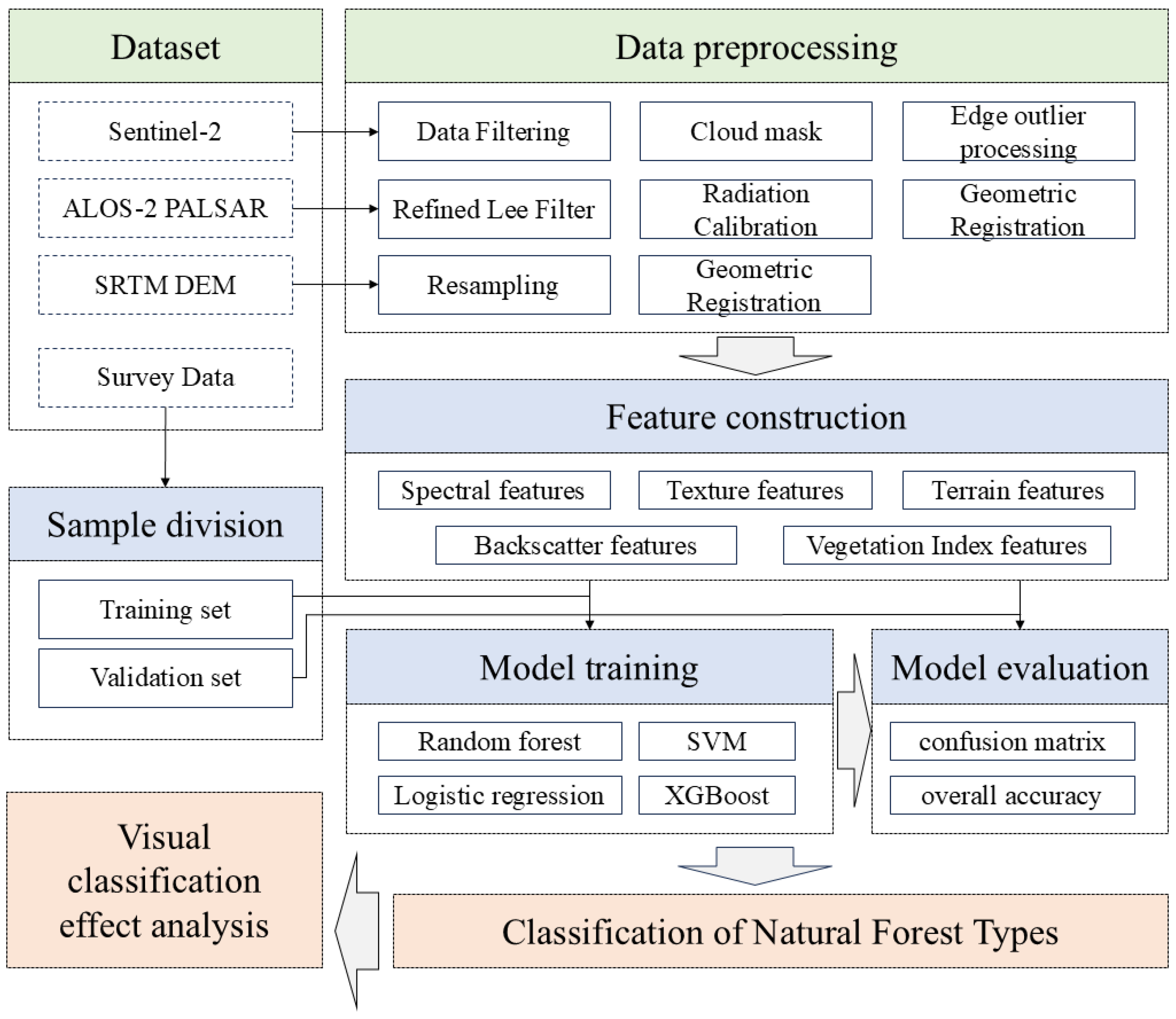
2.3.1. Data Preprocessing
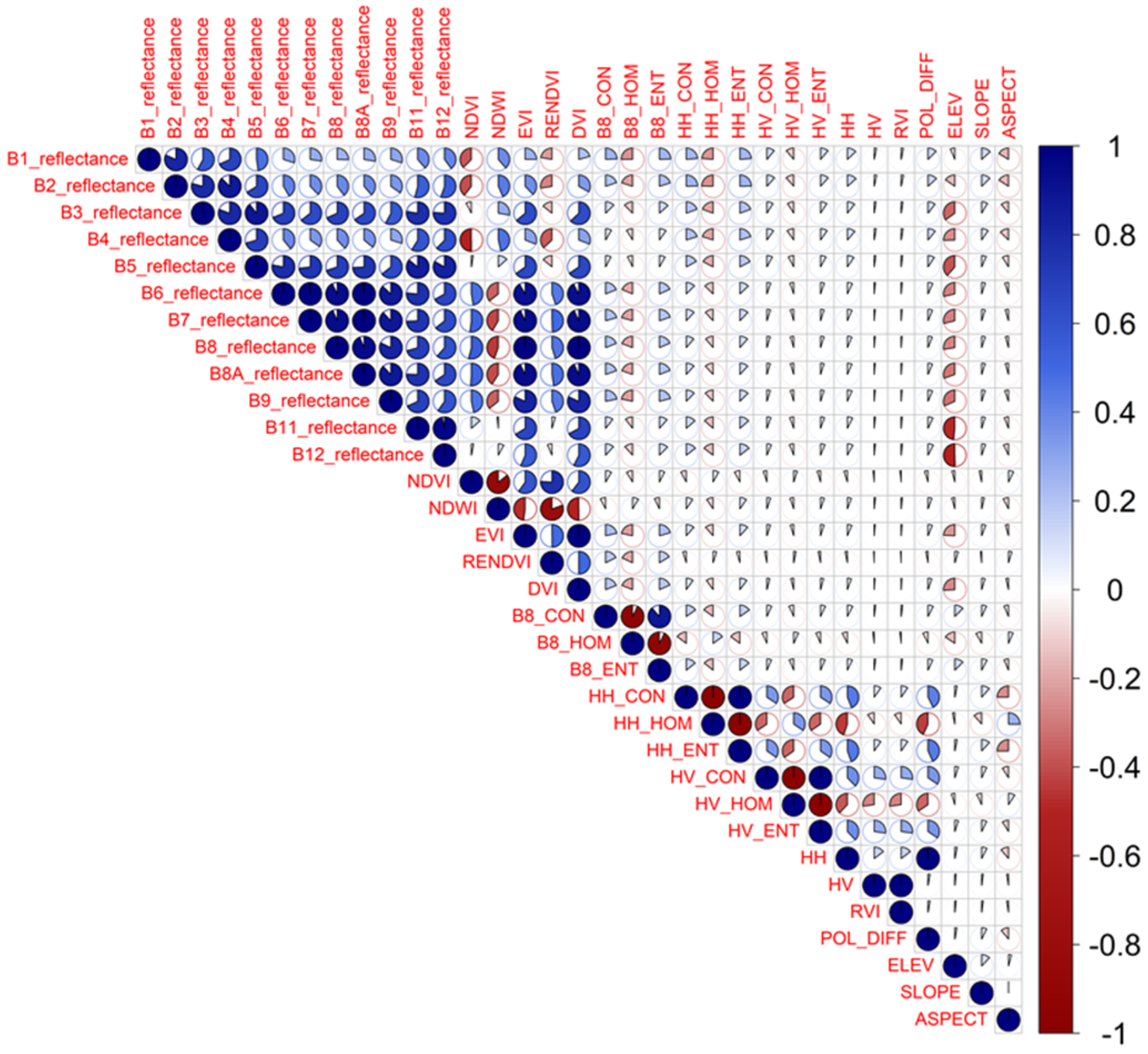
2.3.2. Feature Construction
- Spectral feature.The reflectance values of the visible, near-infrared, and short-wave infrared bands (12 bands) of Sentinel-2 were selected.
- Vegetation index.The vegetation index [37] is an algorithm based on the reflectance spectral information of vegetation canopy for assessing vegetation cover, vigor, growth dynamics, etc. The reflectance of vegetation to different spectra is affected by factors such as plant type and water content. The normalized vegetation index (NDVI) [38], normalized difference water index (NDWI) [39], enhanced vegetation index (EVI) [40], red-edge normalized difference vegetation index (RENDVI) [41], and difference vegetation index (DVI) [42] were calculated in this study.
- Texture feature.Texture is one of the important features for recognizing images, and the Gray-Level Co-occurrence Matrix (GLCM) is a classical method for analyzing statistical texture features [43], which is widely used in image processing and remote sensing analysis for quantitatively portraying the spatial dependence of the pixel gray values of an image. It describes the spatial gray structure of an image by counting the joint probability distribution of pairs of gray values in an image under a particular spatial relationship. Based on the near-infrared band (B8) in the Sentinel-2 image and the HH and HV polarization channels of the ALOS-2 PALSAR image, the three most representative texture features in the GLCM, entropy, contrast, and homogeneity, were selected. A sliding window strategy (7 × 7) was used to traverse the image pixels, and the average values of 0° (horizontal), 45°, 90° (vertical), and 135° were calculated as the final results. Entropy measures the randomness and complexity of the texture, contrast reflects how drastically the gray scale changes, and homogeneity portrays the smoothness or consistency of the image. The computational results in each of the four directions were calculated and then averaged to eliminate the instability caused by the choice of direction, thus enhancing the robustness of the features.
- Backscattering feature.The backscattering coefficient σ0 value (dB) of the dual-polarized (HH and HV) SAR data in the L-band from the ALOS-2 satellite was obtained. The radar vegetation index (RVI) [44] and polarization difference were introduced to characterize the vegetation structural heterogeneity for the tropical vegetation canopy scattering characteristics. An RVI > 0.5 indicates dense vegetation cover, the physical mechanism of which originates from the body scattering-dominated HV polarization enhancement effect.
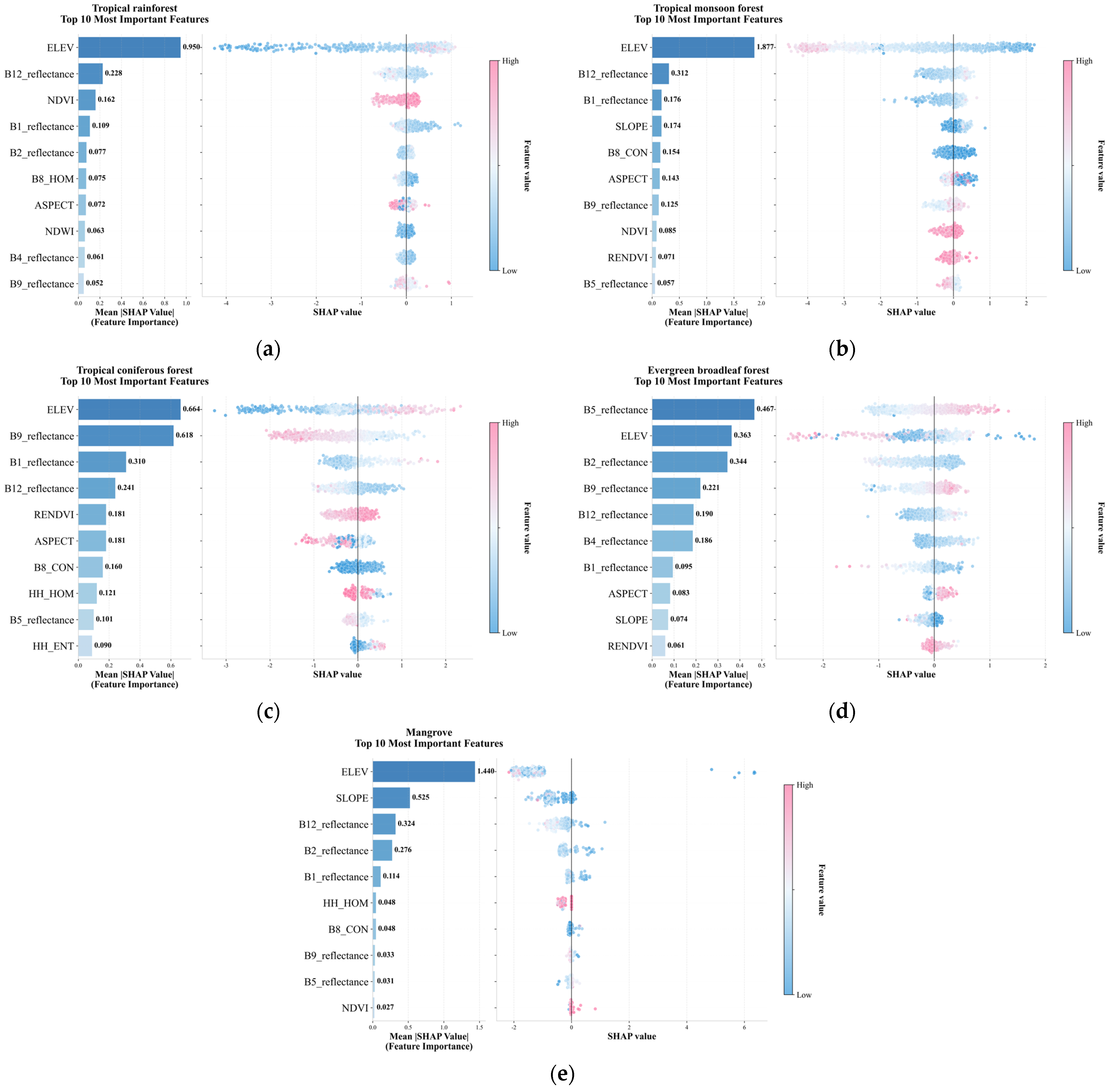
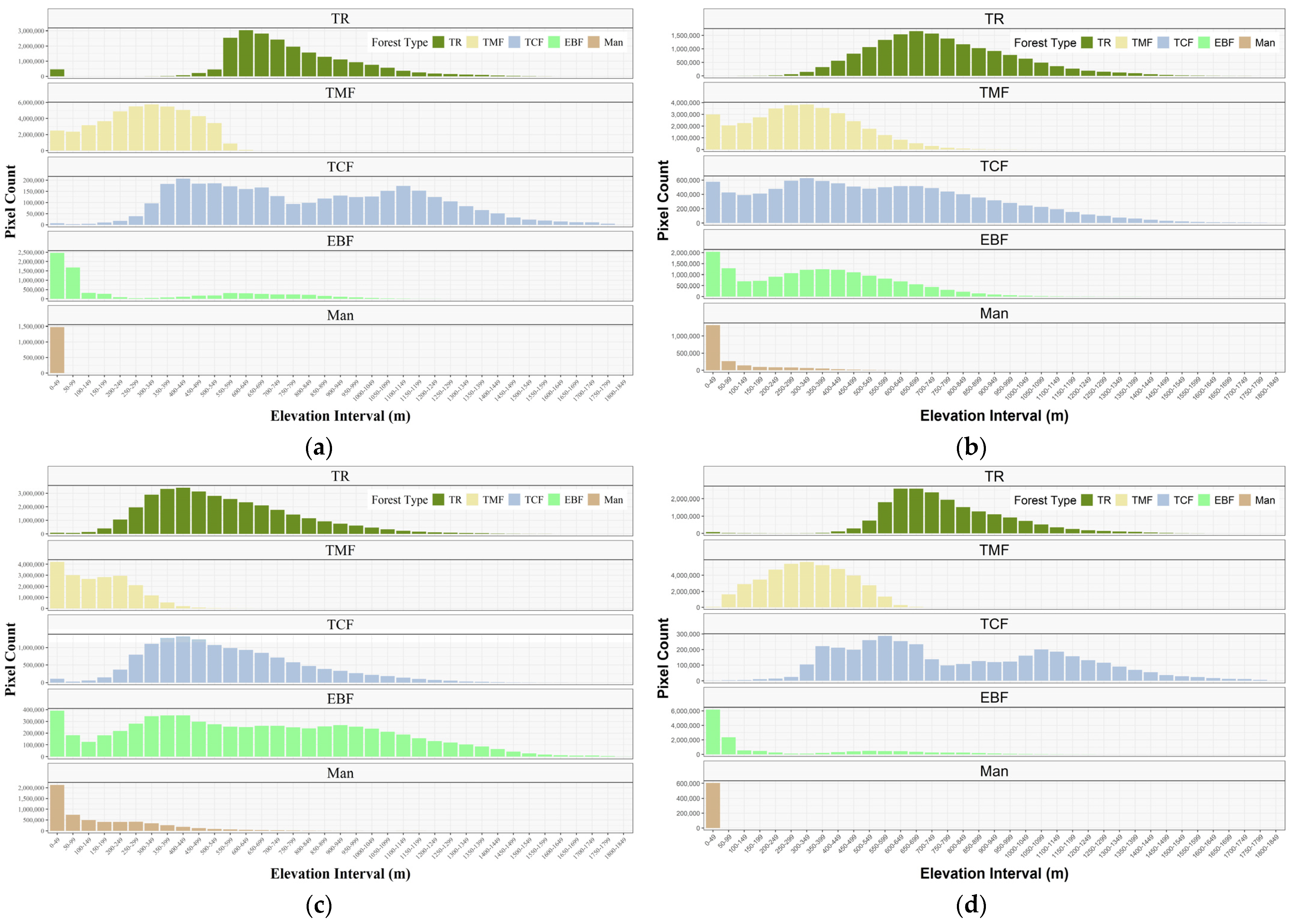
- Topographic feature.Quantitative topographic factors provide key environmental variables for the delineation of tropical forest types, and the spatial distribution of forest types is closely related to topography. Parameters such as elevation, slope, and slope direction covering Hainan Island were obtained based on the resampled SRTM DEM data.
2.3.3. Forest Classification System Construction
2.3.4. Model Training and Evaluation
3. Results and Discussion
3.1. Results
3.1.1. Classification Results
3.1.2. Accuracy of Classification Results
3.1.3. Feature Analysis
3.2. Discussion
3.2.1. Analysis of the Strengths of Joint Optical and SAR in the Local Area
3.2.2. Implications of the Present Study and the Future Work
4. Conclusions
Author Contributions
Funding
Data Availability Statement
Conflicts of Interest
References
- Lewis, S.L.; Wheeler, C.E.; Mitchard, E.T.A.; Koch, A. Restoring Natural Forests Is the Best Way to Remove Atmospheric Carbon. Nature 2019, 568, 25–28. [Google Scholar] [CrossRef]
- FAO. Global Forest Resources Assessment 2020; FAO: Roma, Italy, 2020; ISBN 978-92-5-132581-0. [Google Scholar]
- Marden, M.; Lambie, S.; Phillips, C. Biomass and Root Attributes of Eight of New Zealand’s Most Common Indigenous Evergreen Conifer and Broadleaved Forest Species during the First 5 Years of Establishment. N. Z. J. For. Sci. 2018, 48, 9. [Google Scholar] [CrossRef]
- Qin, Y.; Wang, D.; Ziegler, A.D.; Fu, B.; Zeng, Z. Impact of Amazonian Deforestation on Precipitation Reverses between Seasons. Nature 2025, 639, 102–108. [Google Scholar] [CrossRef] [PubMed]
- Santos, E.G.; Svátek, M.; Nunes, M.H.; Aalto, J.; Senior, R.A.; Matula, R.; Plichta, R.; Maeda, E.E. Structural Changes Caused by Selective Logging Undermine the Thermal Buffering Capacity of Tropical Forests. Agric. For. Meteorol. 2024, 348, 109912. [Google Scholar] [CrossRef]
- Harris, N.L.; Gibbs, D.A.; Baccini, A.; Birdsey, R.A.; de Bruin, S.; Farina, M.; Fatoyinbo, L.; Hansen, M.C.; Herold, M.; Houghton, R.A.; et al. Global Maps of Twenty-First Century Forest Carbon Fluxes. Nat. Clim. Chang. 2021, 11, 234–240. [Google Scholar] [CrossRef]
- Mitchard, E.T.A. The Tropical Forest Carbon Cycle and Climate Change. Nature 2018, 559, 527–534. [Google Scholar] [CrossRef]
- Baccini, A.; Goetz, S.J.; Walker, W.S.; Laporte, N.T.; Sun, M.; Sulla-Menashe, D.; Hackler, J.; Beck, P.S.A.; Dubayah, R.; Friedl, M.A.; et al. Estimated Carbon Dioxide Emissions from Tropical Deforestation Improved by Carbon-Density Maps. Nat. Clim. Chang. 2012, 2, 182–185. [Google Scholar] [CrossRef]
- Gatti, L.V.; Basso, L.S.; Miller, J.B.; Gloor, M.; Gatti Domingues, L.; Cassol, H.L.G.; Tejada, G.; Aragão, L.E.O.C.; Nobre, C.; Peters, W.; et al. Amazonia as a Carbon Source Linked to Deforestation and Climate Change. Nature 2021, 595, 388–393. [Google Scholar] [CrossRef] [PubMed]
- Chen, Y.; Yang, Q.; Mo, Y.; Yang, X.; Li, D.; Hong, X. A study on the niches of the state’s key protected plants in Bawangling, Hainan Island. Chin. J. Plant Ecol. 2014, 38, 576–584. [Google Scholar]
- Gibson, L.; Lee, T.M.; Koh, L.P.; Brook, B.W.; Gardner, T.A.; Barlow, J.; Peres, C.A.; Bradshaw, C.J.A.; Laurance, W.F.; Lovejoy, T.E.; et al. Primary Forests Are Irreplaceable for Sustaining Tropical Biodiversity. Nature 2011, 478, 378–381. [Google Scholar] [CrossRef] [PubMed]
- Flores, B.M.; Montoya, E.; Sakschewski, B.; Nascimento, N.; Staal, A.; Betts, R.A.; Levis, C.; Lapola, D.M.; Esquível-Muelbert, A.; Jakovac, C.; et al. Critical Transitions in the Amazon Forest System. Nature 2024, 626, 555–564. [Google Scholar] [CrossRef]
- Yu, T.; Wu, W.; Gong, C.; Li, X. Residual Multi-Attention Classification Network for A Forest Dominated Tropical Landscape Using High-Resolution Remote Sensing Imagery. ISPRS Int. J. Geo-Inf. 2021, 10, 22. [Google Scholar] [CrossRef]
- Reiche, J.; Lucas, R.; Mitchell, A.L.; Verbesselt, J.; Hoekman, D.H.; Haarpaintner, J.; Kellndorfer, J.M.; Rosenqvist, A.; Lehmann, E.A.; Woodcock, C.E.; et al. Combining Satellite Data for Better Tropical Forest Monitoring. Nat. Clim Chang. 2016, 6, 120–122. [Google Scholar] [CrossRef]
- Moreira, A.; Prats-Iraola, P.; Younis, M.; Krieger, G.; Hajnsek, I.; Papathanassiou, K.P. A Tutorial on Synthetic Aperture Radar. IEEE Geosci. Remote Sens. Mag. 2013, 1, 6–43. [Google Scholar] [CrossRef]
- Kulkarni, S.C.; Rege, P.P. Pixel level fusion techniques for SAR and optical images: A review. Inf. Fusion 2020, 59, 13–29. [Google Scholar] [CrossRef]
- Heckel, K.; Urban, M.; Schratz, P.; Mahecha, M.D.; Schmullius, C. Predicting Forest Cover in Distinct Ecosystems: The Potential of Multi-Source Sentinel-1 and -2 Data Fusion. Remote Sens. 2020, 12, 302. [Google Scholar] [CrossRef]
- Dobrinić, D.; Gašparović, M.; Medak, D. Sentinel-1 and 2 Time-Series for Vegetation Mapping Using Random Forest Classification: A Case Study of Northern Croatia. Remote Sens. 2021, 13, 2321. [Google Scholar] [CrossRef]
- Zhang, Z.; Moore, J.C. Remote Sens.; Elsevier: Amsterdam, The Netherlands, 2015; pp. 111–124. ISBN 978-0-12-800066-3. [Google Scholar]
- Ouchi, K. Recent Trend and Advance of Synthetic Aperture Radar with Selected Topics. Remote Sens. 2013, 5, 716–807. [Google Scholar] [CrossRef]
- Balling, J.; Slagter, B.; van der Woude, S.; Herold, M.; Reiche, J. ALOS-2 PALSAR-2 ScanSAR and Sentinel-1 Data for Timely Tropical Forest Disturbance Mapping: A Case Study for Sumatra, Indonesia. Int. J. Appl. Earth Obs. Geoinf. 2024, 132, 103994. [Google Scholar] [CrossRef]
- Joshi, N.; Baumann, M.; Ehammer, A.; Fensholt, R.; Grogan, K.; Hostert, P.; Jepsen, M.R.; Kuemmerle, T.; Meyfroidt, P.; Mitchard, E.T.A.; et al. A Review of the Application of Optical and Radar Remote Sensing Data Fusion to Land Use Mapping and Monitoring. Remote Sens. 2016, 8, 70. [Google Scholar] [CrossRef]
- Balling, J.; Verbesselt, J.; De Sy, V.; Herold, M.; Reiche, J. Exploring Archetypes of Tropical Fire-Related Forest Disturbances Based on Dense Optical and Radar Satellite Data and Active Fire Alerts. Forests 2021, 12, 456. [Google Scholar] [CrossRef]
- Fan, Y.; Qian, Y.; Gong, W.; Chu, Z.; Qin, Y.; Muhetaer, P. Multi-Level Interactive Fusion Network Based on Adversarial Learning for Fusion Classification of Hyperspectral and LiDAR Data. Expert Syst. Appl. 2024, 257, 125132. [Google Scholar] [CrossRef]
- Zhu, Q.; Guo, H.; Zhang, L.; Liang, D.; Liu, X.; Wan, X.; Liu, J. Tropical Forests Classification Based on Weighted Separation Index from Multi-Temporal Sentinel-2 Images in Hainan Island. Sustainability 2021, 13, 13348. [Google Scholar] [CrossRef]
- Persson, M.; Lindberg, E.; Reese, H. Tree Species Classification with Multi-Temporal Sentinel-2 Data. Remote Sens. 2018, 10, 1794. [Google Scholar] [CrossRef]
- Ye, N. Indigenous Forest Classification in New Zealand—A Comparison of Classifiers and Sensors. Int. J. Appl. Earth Obs. Geoinf. 2021, 102, 102395. [Google Scholar] [CrossRef]
- Martins, G.B.; La Rosa, L.E.C.; Happ, P.N.; Coelho, L.C.T.; Santos, C.J.F.; Feitosa, R.Q.; Ferreira, M.P. Deep Learning-Based Tree Species Mapping in a Highly Diverse Tropical Urban Setting. Urban For. Urban Green. 2021, 64, 127241. [Google Scholar] [CrossRef]
- Lobo Torres, D.; Queiroz Feitosa, R.; Nigri Happ, P.; Elena Cué La Rosa, L.; Marcato Junior, J.; Martins, J.; Olã Bressan, P.; Gonçalves, W.N.; Liesenberg, V. Applying Fully Convolutional Architectures for Semantic Segmentation of a Single Tree Species in Urban Environment on High Resolution UAV Optical Imagery. Sensors 2020, 20, 563. [Google Scholar] [CrossRef]
- Qin, H.; Zhou, W.; Yao, Y.; Wang, W. Individual Tree Segmentation and Tree Species Classification in Subtropical Broadleaf Forests Using UAV-Based LiDAR, Hyperspectral, and Ultrahigh-Resolution RGB Data. Remote Sens. Environ. 2022, 280, 113143. [Google Scholar] [CrossRef]
- Ding, Y.; Liu, G.; Zang, R.; Zhang, J.; Lu, X.; Huang, J. Distribution of Vascular Epiphytes along a Tropical Elevational Gradient: Disentangling Abiotic and Biotic Determinants. Sci. Rep. 2016, 6, 19706. [Google Scholar] [CrossRef]
- Qiu, K.; Lei, C.; Tang, C.; Yang, R.; Willett, S.; Ren, J. Quantitative Analysis of the Fluvial Geomorphology and Erosion on Hainan Island: Implications for the Source-to-Sink System in the NW South China Sea. Front. Mar. Sci. 2024, 11, 1475481. [Google Scholar] [CrossRef]
- Zhang, J.; Wang, D.R.; Jennerjahn, T.; Dsikowitzky, L. Land-Sea Interactions at the East Coast of Hainan Island, South China Sea: A Synthesis. Cont. Shelf Res. 2013, 57, 132–142. [Google Scholar] [CrossRef]
- Zhai, J.; Hou, P.; Cao, W.; Yang, M.; Cai, M.; Li, J. Ecosystem Assessment and Protection Effectiveness of a Tropical Rainforest Region in Hainan Island, China. J. Geogr. Sci. 2018, 28, 415–428. [Google Scholar] [CrossRef]
- Chaves, M.E.D.; Picoli, M.C.A.; Sanches, I.D. Recent Applications of Landsat 8/OLI and Sentinel-2/MSI for Land Use and Land Cover Mapping: A Systematic Review. Remote Sens. 2020, 12, 3062. [Google Scholar] [CrossRef]
- Motohka, T.; Kankaku, Y.; Suzuki, S. Advanced Land Observing Satellite-2 (ALOS-2) and Its Follow-on L-Band SAR Mission. In Proceedings of the 2017 IEEE Radar Conference (RadarConf), Seattle, WA, USA, 8–12 May 2017; pp. 0953–0956. [Google Scholar]
- Xue, J.; Su, B. Significant Remote Sensing Vegetation Indices: A Review of Developments and Applications. J. Sens. 2017, 2017, 1353691. [Google Scholar] [CrossRef]
- Rouse, J.W.; Haas, R.H.; Schell, J.A.; Deering, D.W. Monitoring Vegetation Systems in the Great Plains with ERTS; No. NASA-CR-132982; Texas A&M University Remote Sensing Center: College Station, TX, USA, 1 January 1974. [Google Scholar]
- Gao, B. NDWI—A Normalized Difference Water Index for Remote Sensing of Vegetation Liquid Water from Space. Remote Sens. Environ. 1996, 58, 257–266. [Google Scholar] [CrossRef]
- Huete, A.; Didan, K.; Miura, T.; Rodriguez, E.P.; Gao, X.; Ferreira, L.G. Overview of the Radiometric and Biophysical Performance of the MODIS Vegetation Indices. Remote Sens. Environ. 2002, 83, 195–213. [Google Scholar] [CrossRef]
- Gitelson, A.; Merzlyak, M.N. Spectral Reflectance Changes Associated with Autumn Senescence of Aesculus hippocastanum L. and Acer platanoides L. Leaves. Spectral Features and Relation to Chlorophyll Estimation. J. Plant Physiol. 1994, 143, 286–292. [Google Scholar] [CrossRef]
- Richardson, A.J.; Wiegand, C.L. Distinguishing Vegetation from Soil Background Information. Photogramm. Eng. Remote Sens. 1977, 43, 1541–1552. [Google Scholar]
- Haralick, R.M.; Shanmugam, K.; Dinstein, I. Textural Features for Image Classification. IEEE Trans. Syst. Man Cybern. 1973, SMC-3, 610–621. [Google Scholar] [CrossRef]
- Yadav, V.P.; Prasad, R.; Bala, R.; Srivastava, P.K.; Vanama, V.S.K. Appraisal of Dual Polarimetric Radar Vegetation Index in First Order Microwave Scattering Algorithm Using Sentinel-1A (C-Band) and ALOS-2 (L-Band) SAR Data. Geocarto Int. 2022, 37, 6232–6250. [Google Scholar] [CrossRef]
- Spearman, C. The Proof and Measurement of Association between Two Things. Am. J. Psychol. 1904, 15, 72–101. [Google Scholar] [CrossRef]
- Song, Y. Recognition and proposal on the vegetation classification system of China. Chin. J. Plant Ecol. 2011, 35, 882–892. [Google Scholar] [CrossRef]
- Shi, J.; Gong, C.; Li, X.; Wan, X.; Sun, Z. Classification of Hainan Island Natural Forests Based on Multi-Source Remote Sensing Data. China Sci. Data 2019, 4, 40. [Google Scholar] [CrossRef]
- Breiman, L. Random Forests. Mach. Learn. 2001, 45, 5–32. [Google Scholar] [CrossRef]
- Cortes, C.; Vapnik, V. Support-Vector Networks. Mach Learn 1995, 20, 273–297. [Google Scholar] [CrossRef]
- Cox, D.R. The Regression Analysis of Binary Sequences. J. R. Stat. Soc. Ser. B 1958, 20, 215–242. [Google Scholar] [CrossRef]
- Chen, T.; Guestrin, C. XGBoost: A Scalable Tree Boosting System. In Proceedings of the 22nd ACM SIGKDD International Conference on Knowledge Discovery and Data Mining, New York, NY, USA, 13 August 2016; Association for Computing Machinery: New York, NY, USA, 2016; pp. 785–794. [Google Scholar]
- Salmon, B.P.; Kleynhans, W.; Schwegmann, C.P.; Olivier, J.C. Proper Comparison among Methods Using a Confusion Matrix. In Proceedings of the 2015 IEEE International Geoscience and Remote Sensing Symposium (IGARSS), Milan, Italy, 26–31 July 2015; pp. 3057–3060. [Google Scholar]
- Lundberg, S.M.; Lee, S.-I. A Unified Approach to Interpreting Model Predictions. In Advances in Neural Information Processing Systems; Curran Associates Inc.: Red Hook, NY, USA, 2017; Volume 30. [Google Scholar]
- Zhang, X.; Liu, L.; Chen, X.; Gao, Y.; Xie, S.; Mi, J. GLC_FCS30: Global Land-Cover Product with Fine Classification System at 30 M Using Time-Series Landsat Imagery. Earth Syst. Sci. Data 2021, 13, 2753–2776. [Google Scholar] [CrossRef]
- Chaity, M.D.; van Aardt, J. Exploring the Limits of Species Identification via a Convolutional Neural Network in a Complex Forest Scene through Simulated Imaging Spectroscopy. Remote Sens. 2024, 16, 498. [Google Scholar] [CrossRef]
- Lai, X.; Tang, X.; Ren, Z.; Li, Y.; Huang, R.; Chen, J.; You, H. Study on the Influencing Factors of Forest Tree-Species Classification Based on Landsat and Sentinel-2 Imagery. Forests 2024, 15, 1511. [Google Scholar] [CrossRef]
- Chen, X.; Shen, X.; Cao, L. Tree Species Classification in Subtropical Natural Forests Using High-Resolution UAV RGB and SuperView-1 Multispectral Imageries Based on Deep Learning Network Approaches: A Case Study within the Baima Snow Mountain National Nature Reserve, China. Remote Sens. 2023, 15, 2697. [Google Scholar] [CrossRef]



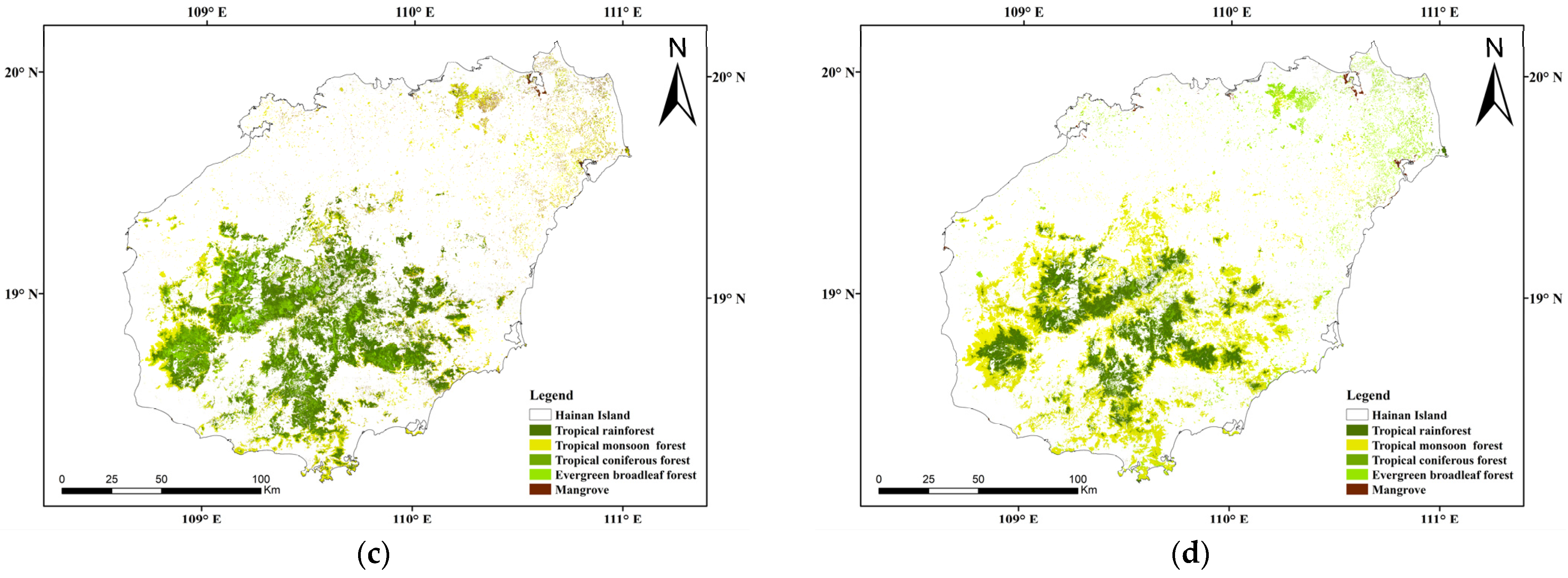
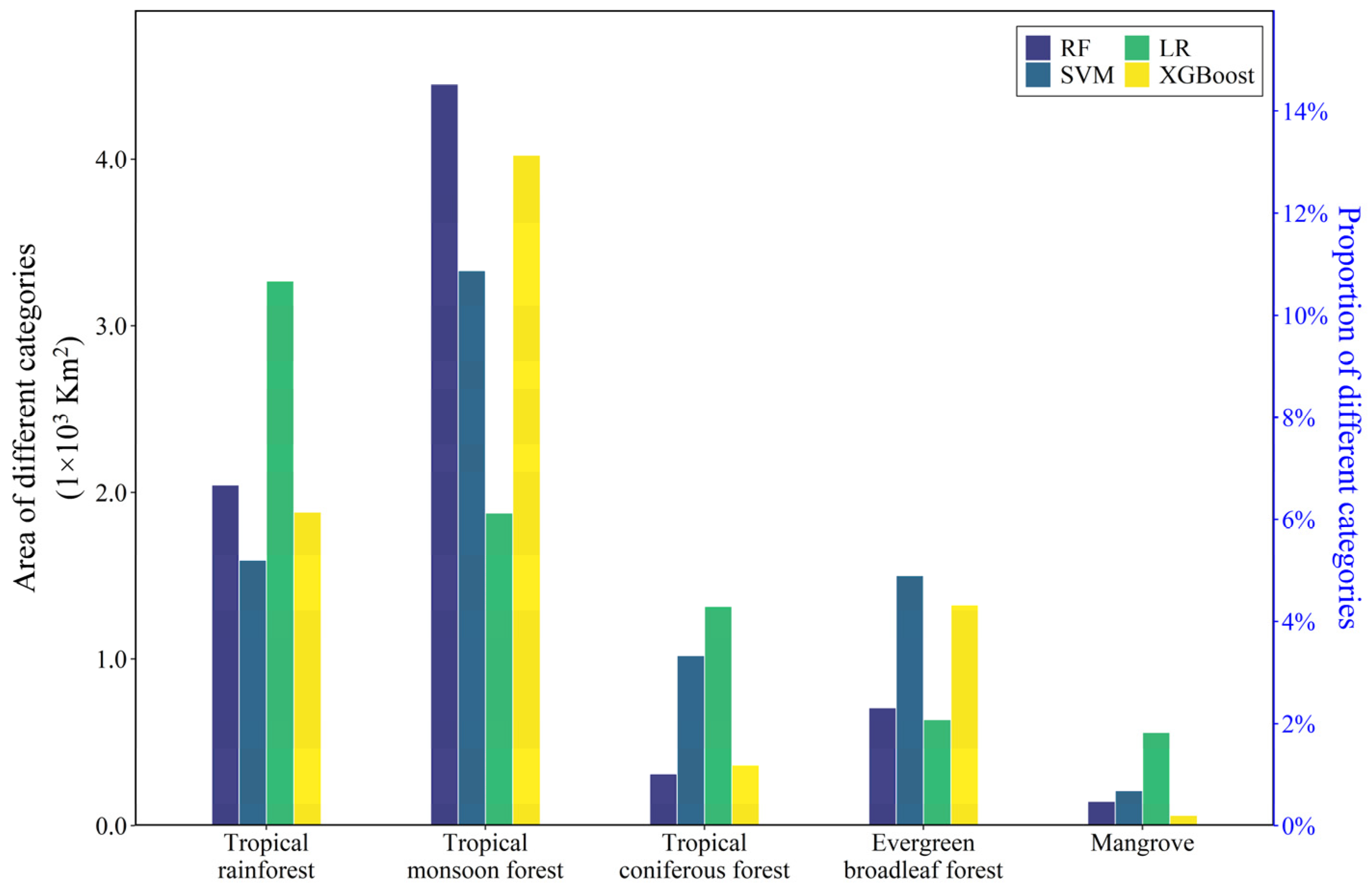
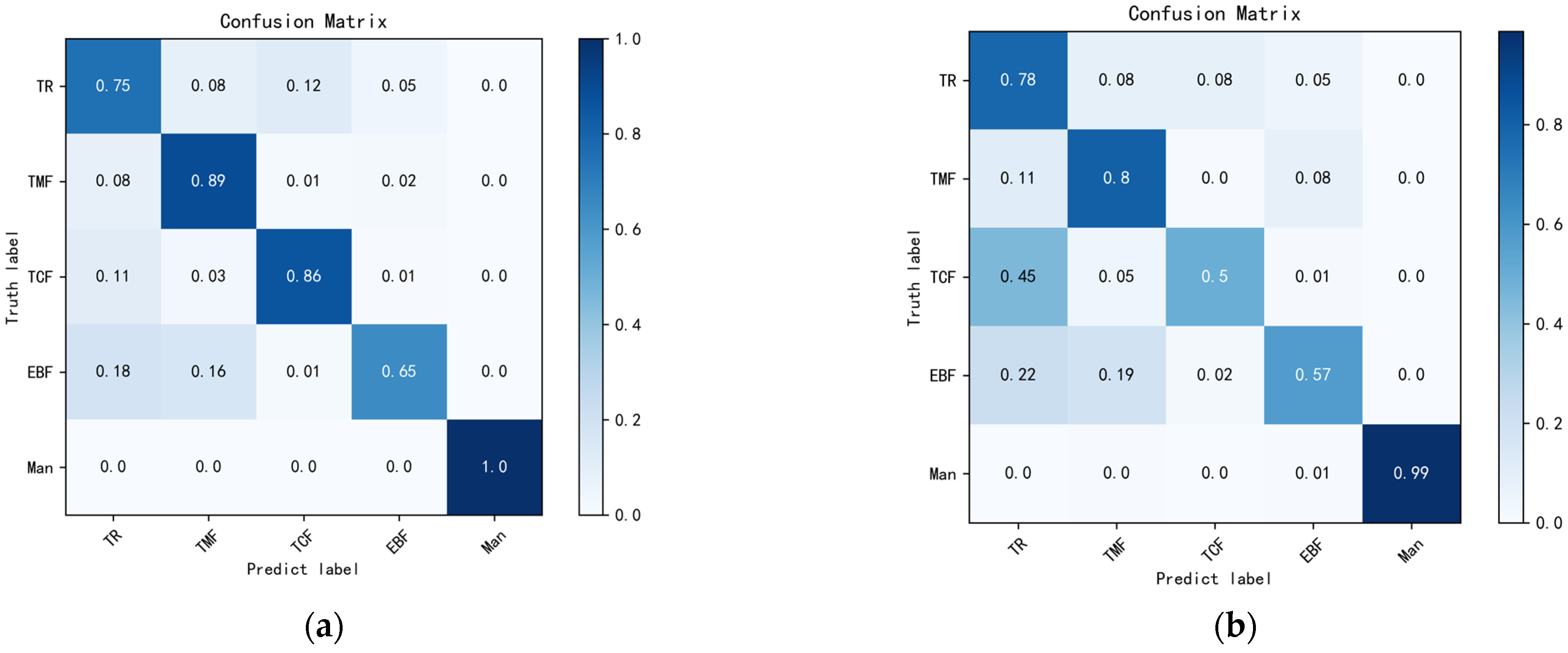
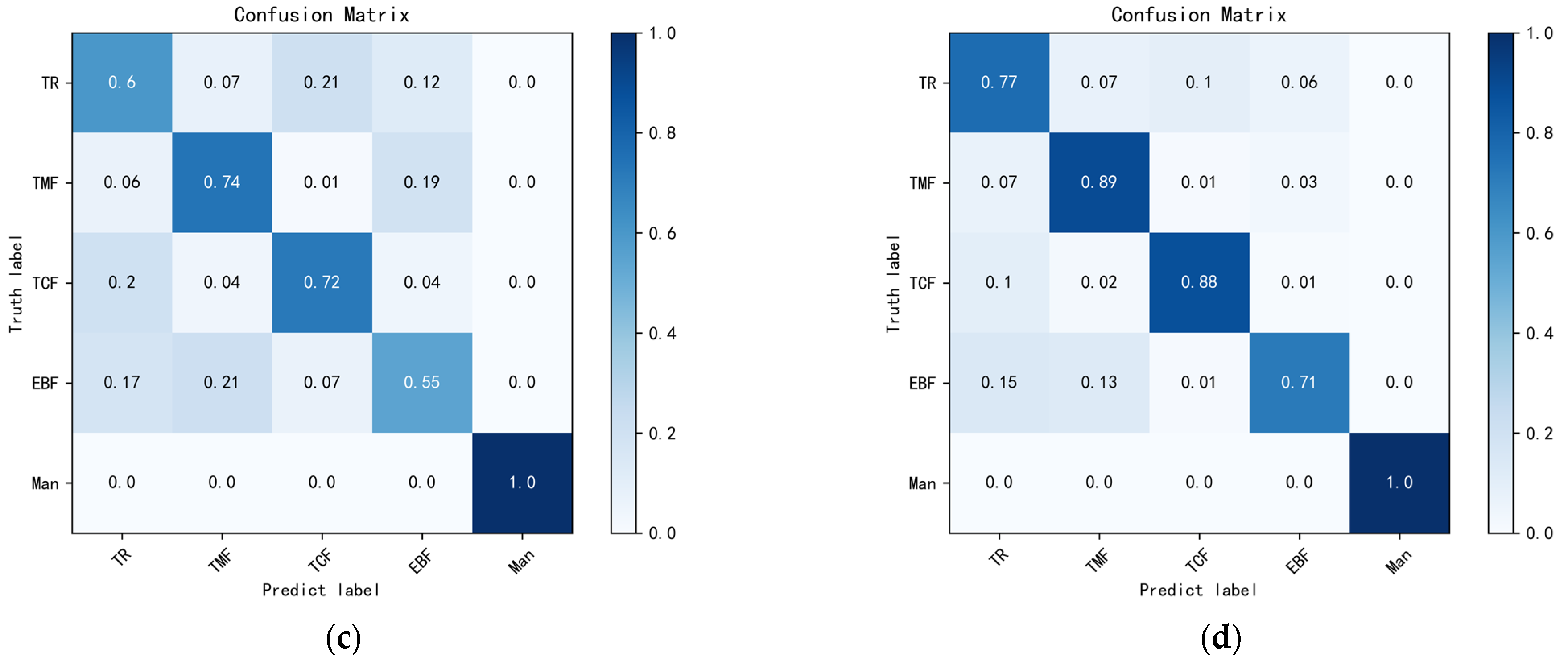
| Data Type | Data Source | Dataset Name | Spatial Resolution | Time Range |
|---|---|---|---|---|
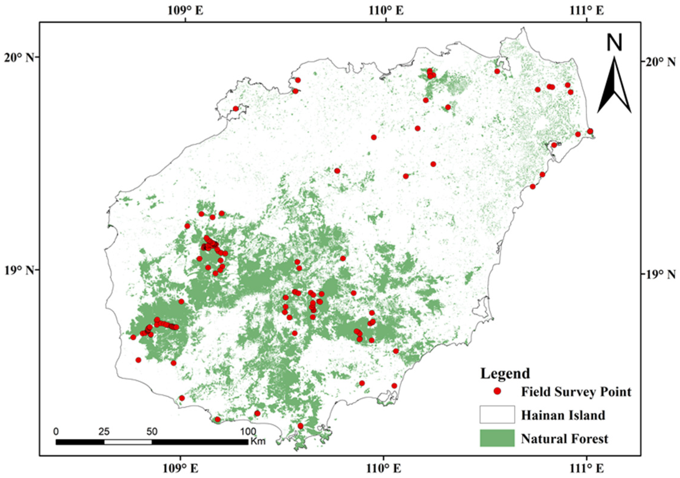
| Remote sensing imagery | Google Earth Engine | Sentinel-2 MSI | 10 m | 2022 |
| JAXA | ALOS-2 PALSAR | 10 m × 10 m | 2022 | |
| DEM | Google Earth Engine | SRTM DEM | 30 m | 2001 |
| Auxiliary data | Field survey | Field survey data | - | 2022 |
| Feature Set | Feature Name | Feature Description |
|---|---|---|
| Spectral feature | Reflectance for the original bands of the Sentinel-2 image | B1, B2, B3, B4, B5, B6, B7, B8, B8A, B9, B11, B12 |
| Vegetation index | Normalized vegetation index (NDVI) | (B8 − B4)/(B8 + b4) |
| Enhanced vegetation index (EVI) | 2.5 × (B8 − B4)/(B8 + 6 × B4 − 7.5 × B2 + 1) | |
| Normalized difference water index (NDWI) | (B3 − B8)/(B3 + B8) | |
| Red-edge normalized difference vegetation index (RENDVI) | (B6 − B5)/(B6 + B5) | |
| Difference vegetation index (DVI) | B8 − B4 | |
| Texture feature | Entropy | HH_ENT, HV_ENT, B8_ENT |
| Contrast | HH_CON, HV_CON, B8_CON | |
| Homogeneity | HH_HOM, HV_HOM, B8_HOM | |
| Backscattering feature | Polarization Backscatter Coefficient (HH) | HH |
| Horizontal–vertical polarization backscatter coefficient (HV) | HV | |
| Radar vegetation index (RVI) | 4 × HV/(HH + HV) | |
| Polarization difference | HH − HV | |
| Topographic feature | Elevation | |
| Slope | ||
| Aspect |
| Primary Class | Secondary Class | Tertiary Class |
|---|---|---|
| Forest | Natural forest | Tropical rainforest |
| Tropical monsoon forest | ||
| Tropical coniferous forest | ||
| Evergreen broadleaf forest | ||
| Mangrove forest |
| Forest Type | Training | Validation | Total | Source |
|---|---|---|---|---|
| Tropical rainforest | 900,852 | 225,146 | 1,125,728 | Field survey + remote sensing interpretation |
| Tropical monsoon forest | 326,409 | 81,603 | 408,012 | Field survey + remote sensing interpretation |
| Tropical coniferous forest | 262,352 | 65,588 | 327,940 | Field survey + remote sensing interpretation |
| Evergreen broadleaf forest | 379,180 | 94,795 | 473,975 | Field survey + remote sensing interpretation |
| Mangrove | 97,491 | 24,373 | 121,864 | Field survey + remote sensing interpretation |
| Total (proportion) | 80% | 20% | 2,457,519 | Pixels |
| Model | Accuracy | F1 Score | Recall | Kappa Coefficient |
|---|---|---|---|---|
| XGBoost | 0.89 | 0.88 | 0.87 | 0.82 |
| RF | 0.83 | 0.82 | 0.81 | 0.77 |
| SVM | 0.73 | 0.73 | 0.73 | 0.62 |
| LR | 0.68 | 0.65 | 0.63 | 0.56 |
| Forest Class | Model | User’s Accuracy | Producer’s Accuracy | F1 Score |
|---|---|---|---|---|
| Tropical rainforest | XGBoost | 0.71 | 0.77 | 0.74 |
| RF | 0.67 | 0.75 | 0.71 | |
| SVM | 0.50 | 0.78 | 0.61 | |
| LR | 0.58 | 0.60 | 0.59 | |
| Tropical monsoon forest | XGBoost | 0.80 | 0.89 | 0.84 |
| RF | 0.77 | 0.89 | 0.82 | |
| SVM | 0.71 | 0.80 | 0.75 | |
| LR | 0.69 | 0.74 | 0.72 | |
| Tropical coniferous forest | XGBoost | 0.88 | 0.88 | 0.88 |
| RF | 0.86 | 0.86 | 0.86 | |
| SVM | 0.83 | 0.50 | 0.62 | |
| LR | 0.71 | 0.71 | 0.72 | |
| Evergreen broadleaf forest | XGBoost | 0.88 | 0.71 | 0.79 |
| RF | 0.89 | 0.65 | 0.75 | |
| SVM | 0.79 | 0.57 | 0.67 | |
| LR | 0.61 | 0.55 | 0.58 | |
| Mangrove | XGBoost | 1.00 | 1.00 | 1.00 |
| RF | 1.00 | 1.00 | 1.00 | |
| SVM | 1.00 | 0.99 | 0.99 | |
| LR | 1.00 | 1.00 | 1.00 |
Disclaimer/Publisher’s Note: The statements, opinions and data contained in all publications are solely those of the individual author(s) and contributor(s) and not of MDPI and/or the editor(s). MDPI and/or the editor(s) disclaim responsibility for any injury to people or property resulting from any ideas, methods, instructions or products referred to in the content. |
© 2025 by the authors. Licensee MDPI, Basel, Switzerland. This article is an open access article distributed under the terms and conditions of the Creative Commons Attribution (CC BY) license (https://creativecommons.org/licenses/by/4.0/).
Share and Cite
Xie, Q.; Fu, W.; Yan, W.; Shi, J.; Hao, C.; Li, H.; Xu, S.; Li, X. Research Analysis of the Joint Use of Sentinel-2 and ALOS-2 Data in Fine Classification of Tropical Natural Forests. Forests 2025, 16, 1302. https://doi.org/10.3390/f16081302
Xie Q, Fu W, Yan W, Shi J, Hao C, Li H, Xu S, Li X. Research Analysis of the Joint Use of Sentinel-2 and ALOS-2 Data in Fine Classification of Tropical Natural Forests. Forests. 2025; 16(8):1302. https://doi.org/10.3390/f16081302
Chicago/Turabian StyleXie, Qingyuan, Wenxue Fu, Weijun Yan, Jiankang Shi, Chengzhi Hao, Hui Li, Sheng Xu, and Xinwu Li. 2025. "Research Analysis of the Joint Use of Sentinel-2 and ALOS-2 Data in Fine Classification of Tropical Natural Forests" Forests 16, no. 8: 1302. https://doi.org/10.3390/f16081302
APA StyleXie, Q., Fu, W., Yan, W., Shi, J., Hao, C., Li, H., Xu, S., & Li, X. (2025). Research Analysis of the Joint Use of Sentinel-2 and ALOS-2 Data in Fine Classification of Tropical Natural Forests. Forests, 16(8), 1302. https://doi.org/10.3390/f16081302


