
Using DAP-RPA Point Cloud-Derived Metrics to Monitor Restored Tropical Forests in Brazil
 , ,
, ,
Abstract
1. Introduction
2. Materials and Methods
2.1. Study Area
2.2. Restoration Systems
2.3. Forest Inventory
2.3.1. Sampling
2.3.2. Georeferencing of Parcels
2.3.3. Tree Measurement Methods
2.4. Measurement Uncertainties
2.5. Estimation of AGB and Associated Uncertainties
2.6. Shannon Diversity Index (H′)
2.7. Digital Aerial Photogrammetry (DAP)
2.7.1. Obtaining Images
2.7.2. Aerial Photogrammetric Processing
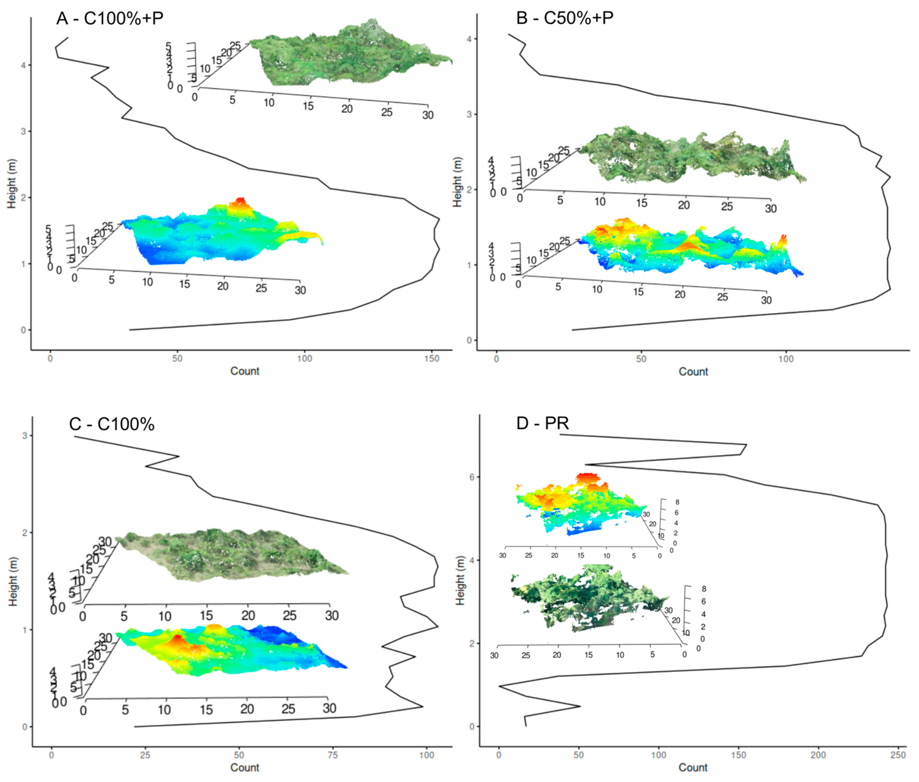
2.7.3. DAP-RPA Metrics
2.7.4. Photogrammetry Evaluation
2.8. Adjustment of Regression Models
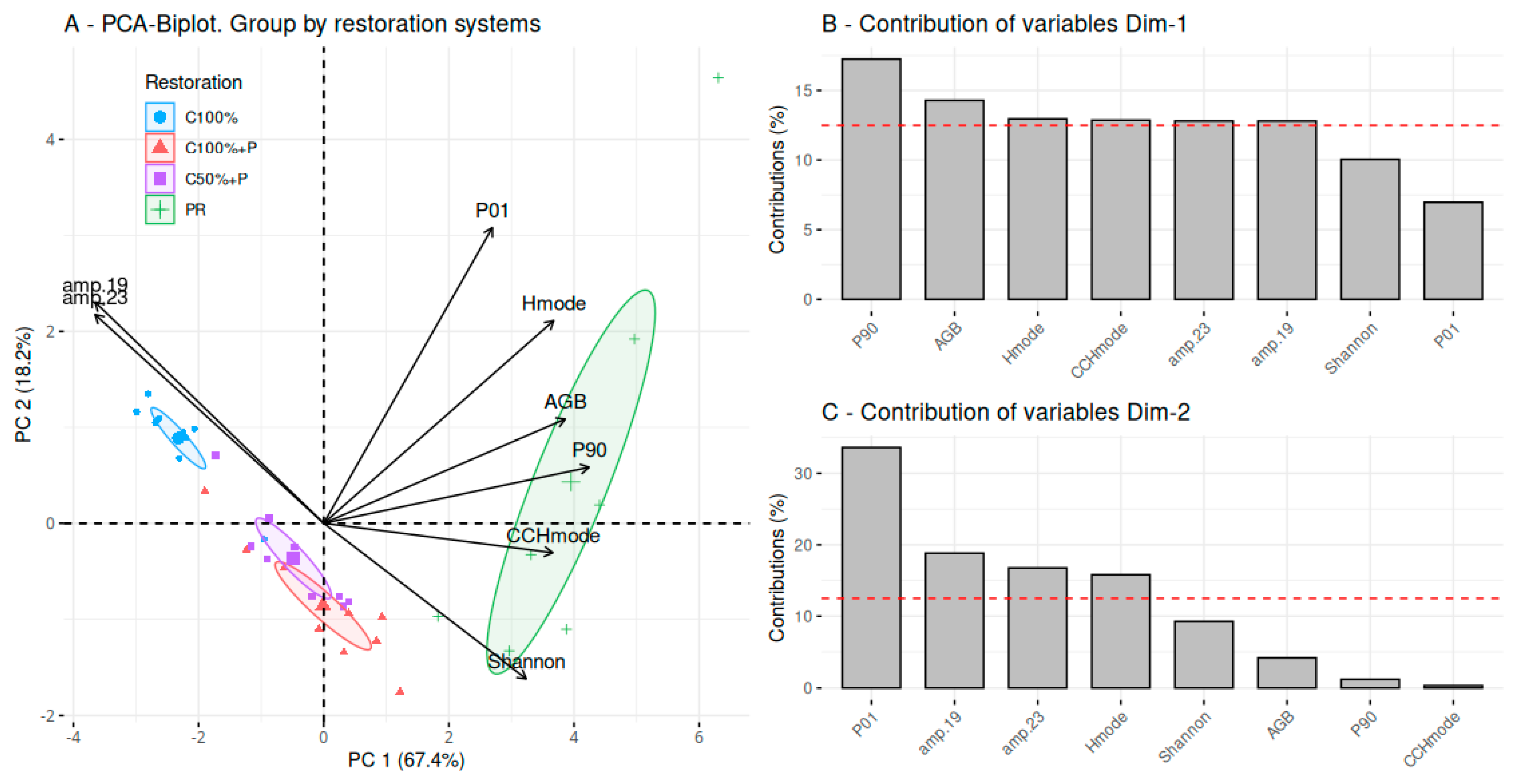
2.9. Principal Component Analysis
3. Results
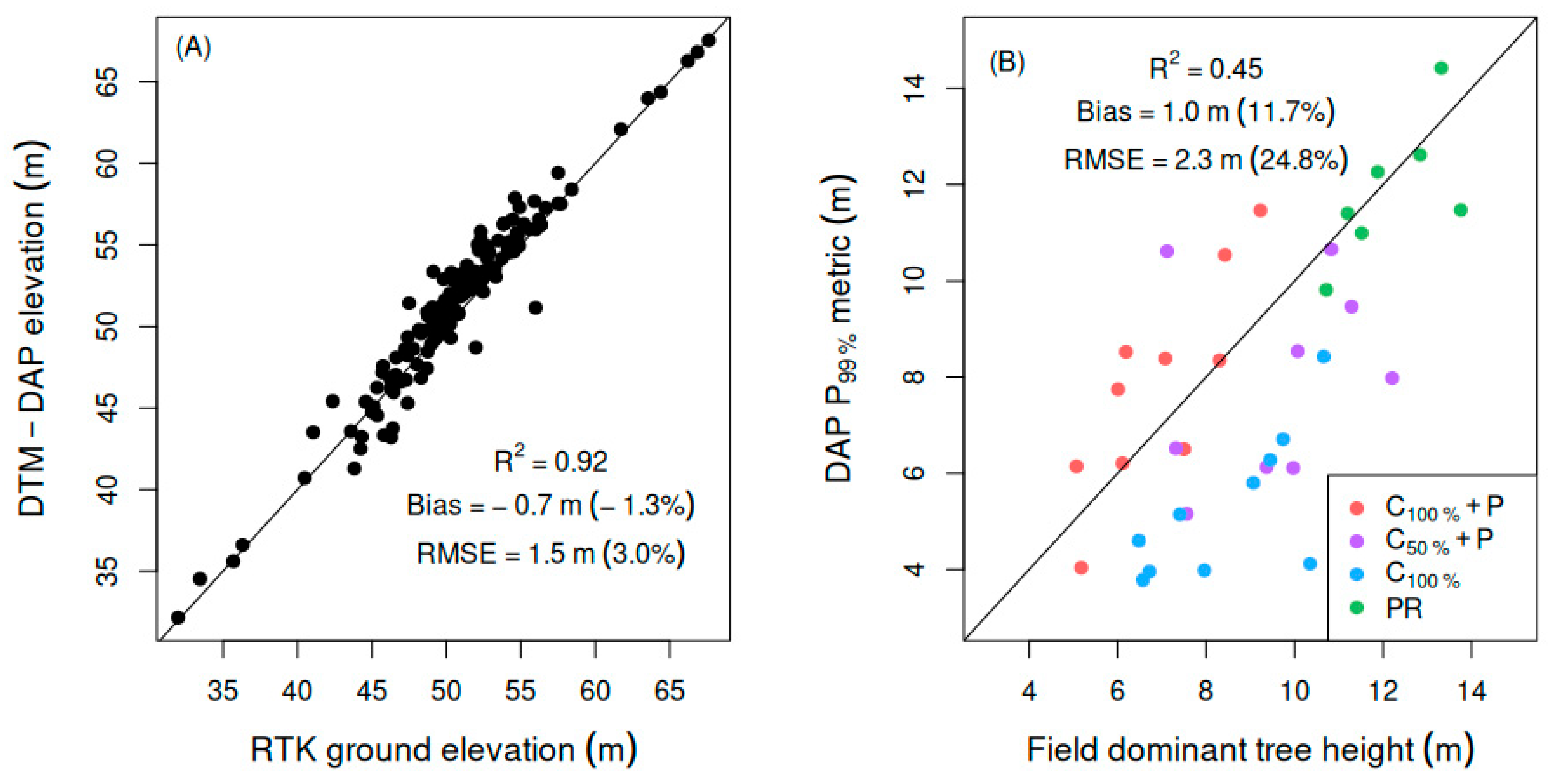
3.1. Photogrammetry Assessment
3.2. Forest Inventory Errors and Uncertainties Associated with AGB
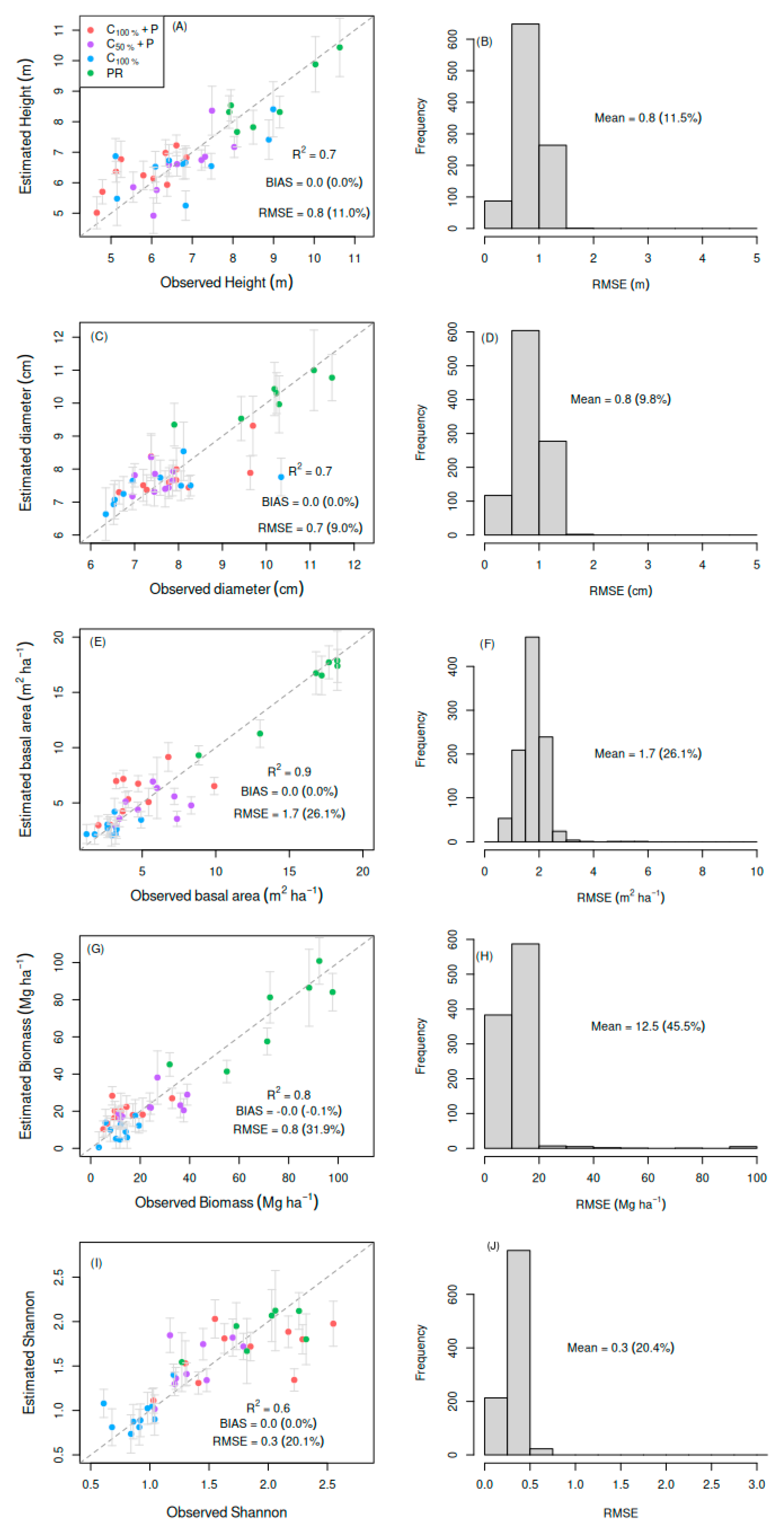
3.3. Statistical Models
3.4. Principal Component Analysis (PCA)
4. Discussion
5. Conclusions
Author Contributions
Funding
Data Availability Statement
Acknowledgments
Conflicts of Interest
References
- Bustamante, M.M.C.; Silva, J.S.; Scariot, A.; Sampaio, A.B.; Mascia, D.L.; Garcia, E.; Sano, E.; Fernandes, G.W.; Durigan, G.; Roitman, I.; et al. Ecological restoration as a strategy for mitigating and adapting to climate change: Lessons and challenges from Brazil. Mitig. Adapt. Strateg. Glob. Change 2019, 24, 1249–1270. [Google Scholar] [CrossRef]
- Almeida, D.R.A.; Stark, S.C.; Chazdon, R.; Nelson, B.W.; Cesar, R.G.; Meli, P.; Gorgens, E.B.; Duarte, M.M.; Valbuena, R.; Moreno, V.S.; et al. The effectiveness of lidar remote sensing for monitoring forest cover attributes and landscape restoration. For. Ecol. Manag. 2019, 438, 34–43. [Google Scholar] [CrossRef]
- Camarretta, N.; Harrison, P.A.; Bailey, T.; Potts, B.; Lucieer, A.; Davidson, N.; Hunt, M. Monitoring forest structure to guide adaptive management of forest restoration: A review of remote sensing approaches. New For. 2020, 51, 573–596. [Google Scholar] [CrossRef]
- Scheeres, J.; de Jong, J.; Brede, B.; Brancalion, P.H.S.; Broadbent, E.N.; Zambrano, A.M.A.; Gorgens, E.B.; Silva, C.A.; Valbuena, R.; Molin, P.; et al. Distinguishing forest types in restored tropical landscapes with UAV-borne LIDAR. Remote Sens. Environ. 2023, 290, 1–14. [Google Scholar] [CrossRef]
- Zahawi, R.A.; Reid, J.L.; Holl, K.D. Hidden Costs of Passive Restoration. Restor. Ecol. 2014, 22, 284–287. [Google Scholar] [CrossRef]
- Yip, K.H.A.; Liu, R.; Wu, J.; Hau, B.C.H.; Lin, Y.; Zhang, H. Community-based plant diversity monitoring of a dense-canopy and species-rich tropical forest using airborne LiDAR data. Ecol. Indic. 2024, 158, 1–12. [Google Scholar] [CrossRef]
- Almeida, A.; Gonçalves, F.; Silva, G.; Souza, R.; Treuhaft, R.; Santos, W.; Loureiro, D.; Fernandes, M. Estimating structure and biomass of a secondary Atlantic forest in Brazil using fourier transforms of vertical profiles derived from UAV photogrammetry point clouds. Remote Sens. 2020, 12, 3560. [Google Scholar] [CrossRef]
- Lin, J.; Wang, M.; Ma, M.; Lin, Y. Aboveground tree biomass estimation of sparse subalpine coniferous forest with UAV oblique photography. Remote Sens. 2018, 10, 1849. [Google Scholar] [CrossRef]
- Navarro, A.; Algeet, N.; Fernández-Landa, A.; Esteban, J.; Rodríguez-Noriega, P.; Guillén-Climent, M.L. Integration of UAV, Sentinel-1, and Sentinel-2 Data for Mangrove Plantation Aboveground Biomass Monitoring in Senegal. Remote Sens. 2019, 11, 77. [Google Scholar] [CrossRef]
- Chen, C.; Liu, W.; Jiang, X.; Wu, J. Effects of rubber-based agroforestry systems on soil aggregation and associated soil organic carbon: Implications for land use. Geoderma 2017, 299, 13–24. [Google Scholar] [CrossRef]
- Cabral, R.P.; da Silva, G.F.; de Almeida, A.Q.; Bonilla-Bedoya, S.; Dias, H.M.; De Mendonça, A.R.; Rodrigues, N.M.M.; Valente, C.C.A.; Oliveira, K.; Gonçalves, F.G.; et al. Mapping of the Successional Stage of a Secondary Forest Using Point Clouds Derived from UAV Photogrammetry. Remote Sens. 2023, 15, 509. [Google Scholar] [CrossRef]
- Embrapa. Sistema Brasileiro de Classificação de Solos, 2nd ed.; Embrapa Solos: Brasília, Brazil, 2006; p. 306. [Google Scholar]
- Fontes, J.A.C. Caracterização Geoambiental da Sub-Bacia do Rio Fundo. Master’s Dissertation, Federal University of Sergipe, São Cristovão, Brazil, 2010. [Google Scholar]
- Chave, J.; Andalo, C.; Brown, S.; Cairns, M.A.; Chambers, J.Q.; Eamus, D.; Fölster, H.; Fromard, F.; Higuchi, N.; Kira, T.; et al. Tree allometry and improved estimation of carbon stocks and balance in tropical forests. Oecologia 2005, 145, 87–99. [Google Scholar] [CrossRef]
- Chave, J.; Muller-Landau, H.C.; Baker, T.R.; Easdale, T.A.; Ter Steege, H.; Webb, C.O. Regional and phylogenetic variation of wood density across neotropical tree species. Ecol. Appl. 2006, 16, 2356–2367. [Google Scholar] [CrossRef]
- Brown, S. Estimating Biomass and Biomass Change of Tropical Forests: A Primer, 134th ed.; FAO Forestry Paper Edition: Rome, Italy, 1997; p. 134. [Google Scholar]
- Chambers, J.Q.; Santos, J.; Ribeiro, R.J.; Higuchi, N. Tree damage, allometric relationships, and above-ground net primary production in central Amazon forest. For. Ecol. Manag. 2001, 152, 73–84. [Google Scholar] [CrossRef]
- Brown, S.; Gillespie, A.J.R.; Lugo, A.E. Biomass estimation methods for tropical forests with applications to forest inventory data. For. Sci. 1989, 35, 881–902. [Google Scholar] [CrossRef]
- Gonçalves, F.; Treuhaft, R.; Law, B.; Almeida, A.Q.; Walker, W.; Baccini, A.; dos Santos, J.R.; Graça, P. Estimating aboveground biomass in tropical forests: Field methods and error analysis for the calibration of remote sensing observations. Remote Sens. 2017, 9, 47. [Google Scholar] [CrossRef]
- Soares, C.P.B.; Paula-Neto, F.; Souza, A.L. Dendrometria e Inventário Florestal, 2nd ed.; Editora UFV: Viçosa, Brazil, 2012; p. 276. [Google Scholar]
- Dandois, J.P.; Olano, M.; Ellis, E.C. Optimal altitude, overlap, and weather conditions for computer vision UAV estimates of forest structure. Remote Sens. 2015, 7, 13895–13920. [Google Scholar] [CrossRef]
- Agisoft. Agisoft Metashape User Manual, version 2.0; Agisoft Metashape: St. Petersburg, Russia, 2023.
- Iglhaut, J.; Cabo, C.; Puliti, S.; Piermattei, L.; O’Connor, J.; Rosette, J. Structure from Motion Photogrammetry in Forestry: A Review. Curr. For. Rep. 2019, 5, 155–168. [Google Scholar] [CrossRef]
- Axelsson, P. Processing of laser scanner data—Algorithms and applications. ISPRS J. Photogramm. Remote Sens. 1999, 54, 138–147. [Google Scholar] [CrossRef]
- R Core Team. R: A Language and Environment for Statistical Computing; R Foundation for Statistical Computing: Vienna, Austria, 2025; Available online: https://www.r-project.org/ (accessed on 15 May 2024).
- Roussel, J.R.; Autyb, D.; Coops, N.C.; Tompalski, P.; Goodbody, T.R.H.; Meadorb, A.S.; Bourdond, J.F.; Boissieu, F.; Achim, A. lidR: An R package for analysis of Airborne Laser Scanning (ALS) data. Remote Sens. Environ. 2020, 251, 1–15. [Google Scholar] [CrossRef]
- McGaughey, R.J. FUSION—Software for Lidar Data Analysis and Visualization; US Forest Service: Washington, DC, USA, 2023.
- Lumley, T. The Leaps Package for Regression Subset Selection; R Package Version 2.9; R Core Team: Vienna, Austria, 2004. [Google Scholar]
- Lê, S.; Josse, J.; Husson, F. FactoMineR: An R Package for Multivariate Analysis. J. Stat. Softw. 2008, 25, 253–258. [Google Scholar] [CrossRef]
- Kassambara, A.; Mundt, F. factoextra: Extract and Visualize the Results of Multivariate Data Analyses; Package Version 1.0.7; R Core Team: Vienna, Austria, 2020. [Google Scholar]
- Goodbody, T.R.H.; Coops, N.C.; Marshall, P.L.; Tompalski, P.; Crawford, P. Unmanned aerial systems for precision forest inventory purposes: A review and case study. For. Chron. 2017, 93, 71–81. [Google Scholar] [CrossRef]
- Panagiotidis, D. Abdollahnejad, Determining tree height and crown diameter from high-resolution UAV imagery. Int. J. Rem. Sens. 2017, 38, 8–10. [Google Scholar] [CrossRef]
- Almeida, M.V.V. Biomass Estimation and Structural Characterization of Restored Areas of the Atlantic Forest with 3D Data Obtained from Digital Aerial Photogrammetry. Master’s Dissertation, Postgraduate Program in Development and Environment—PRODEMA/Federal University of Sergipe, São Cristovão, Brazil, 2023. [Google Scholar]
- Kachamba, D.J.; Eid, T.; Gobakken, T. Above- and belowground biomass models for trees in the miombo woodlands of Malawi. Forests 2016, 7, 38. [Google Scholar] [CrossRef]
- Torresani, M.; Rocchini, D.; Sonnenschein, R.; Zebisch, M.; Hauffe, H.C.; Heym, M.; Pretzsch, H.; Tonon, G. Height variation hypothesis: A new approach for estimating forest species diversity with CHM LiDAR data. Ecol. Indic. 2020, 117, 307–321. [Google Scholar] [CrossRef]
- Duncanson, L.; Armston, J.; Disney, M.; Avitabile, V.; Barbier, N.; Calders, K.; Carter, S.; Chave, J.; Herold, M.; MacBean, N.; et al. Aboveground Woody Biomass Product Validation Good Practices Protocol, 2nd ed.; Duncanson, L., Disney, M., Armston, J., Nickeson, J., Minor, D., Camacho, F., Eds.; Good Practices for Satellite Derived Land Product Validation: Maryland, MD, USA, 2021; Volume 1, pp. 240–256. [Google Scholar]
- Domingo, D.; Ørka, H.O.; Næsset, E.; Kachamba, D.; Gobakken, T. Effects of UAV image resolution, camera type, and image overlap on accuracy of biomass predictions in a tropical woodland. Remote Sens. 2019, 11, 948. [Google Scholar] [CrossRef]
- Ming, L.; Liu, J.; Quan, Y.; Li, M.; Wang, B.; Wei, G. Mapping tree species diversity in a typical natural secondary forest by combining multispectral and LiDAR data. Ecol. Indic. 2024, 159, 1–12. [Google Scholar] [CrossRef]
- Pinon, T.B.M.; Mendonça, A.R.; Silva, G.F.; Effgen, E.M.; Rodrigues, N.M.M.; Fernandes, M.M.; Sansevero, J.B.B.; Almeida, C.T.; Dias, H.M.; Gonçalves, F.G.; et al. Biodiversity from the Sky: Testing the Spectral Variation Hypothesis in the Brazilian Atlantic Forest. Remote Sens. 2024, 16, 4363. [Google Scholar] [CrossRef]
- Sousa, A.M.O.; Gonçalves, A.C.; Mesquita, P.; Marques da Silva, J.R. Biomass estimation with high resolution satellite images: A case study of Quercus rotundifolia. ISPRS J. Photogramm. Remote Sens. 2015, 101, 69–79. [Google Scholar] [CrossRef]
- Treuhaft, R.N.; Gonçalves, F.G.; Drake, J.B.; Chapman, B.D.; Dos Santos, J.R.; Dutra, L.V.; Graça, P.M.L.A.; Purcell, G.H. Biomass estimation in a tropical wet forest using Fourier transforms of profiles from lidar or interferometric SAR. Geophys. Res. Lett. 2010, 37, 1–5. [Google Scholar] [CrossRef]


| Equations | References | |
|---|---|---|
| Btree = exp[−2.997 + log(ρ × dbh2 × h)] | (4) | |
| Btree2 = exp(−2.134 + 2.53ln(dbh)) | (5) | [16] |
| Btree3 = ρ exp(−1.499 + 2.148 ln(dbh) + 0.207 ln(dbh)2 − 0.0281 ln(dbh)3) | (6) | [14] |
| Btree4 = exp(−0.37 + 0.333 ln(dbh) + 0.933 ln(dbh)2 − 0.122 ln(dbh)3) | (7) | [17] |
| Btree5 = exp(−3.1141 + 0.9719 ln(dbh2h)) | (8) | [18] |
| Equations | β0 | β1 | β2 | β3 | RSE | R2 | AIC | R2aj | MSE | SE |
|---|---|---|---|---|---|---|---|---|---|---|
| Btree | −2.997 | ----- | ----- | ----- | 0.316 | 0.989 | 972 | ----- | ----- | 15.63 |
| Btree2 | −2.134 | 2.53 | ----- | ----- | 0.310 | 0.961 | ----- | 0.970 | ----- | 10.6 |
| Btree3 | −1.499 | 2.148 | 0.207 | 0.0281 | 0.356 | 0.996 | 1869 | 19.48 | ||
| Btree4 | −0.37 | 0.333 | 0.933 | 0.122 | 0.973 | 0.297 | ----- | |||
| Btree5 | −3.1141 | 0.9719 | ----- | ----- | 0.341 | ----- | ----- | 0.970 | 0.1161 | ----- |
| Metric Type | Variable |
|---|---|
| Height | Minimum (Hmin) |
| Max (Hmax) | |
| Mean (Hmean) | |
| Mode (Hmode) | |
| Coefficient of variation (Hcv) | |
| Standard deviation (HSD) | |
| Variance (HV) | |
| Interquartile (HIQ) | |
| Asymmetry (Hskew) | |
| Kurtosis (Hcurt) | |
| Percentiles (P01, P05, P10, P20, HP25, P30, P40, P50, P60, P70, P75, P80, HP90, P95, P99) | |
| Generalized square root mean (HSQRTmeanSQ) | |
| Generalized cubic root mean (HCURTmeanCUBE) | |
| Mean absolute deviation (HAAD) | |
| Median absolute deviation from median height (HMADMedian) | |
| Median absolute height mode deviation (HMADMode) | |
| Linear moments (HL1, HL2, HL3, HL4) | |
| Linear moment asymmetry height (HLskew) | |
| Coefficient of variation of linear moments (HLcv) | |
| Canopy Relief Ratio (HCRR) (Hmean − Hmin)/(Hmax − Hmin) | |
| Canopy cover | Total all returns (CCH) |
| All returns above the mean height (CCHmean) | |
| All returns above the height mode value (CCHmode) | |
| Percentage of all returns > average height in relation to the total number of points (CC%Hmean) | |
| Percentage of all returns > mode height relative to total number of points (CC%Hmode) | |
| Fourier | Amplitudes (amp. 01, amp. 02, amp. 03, …, amp. 30) |
| Variable | Range | RMSD | Bias | SD |
|---|---|---|---|---|
| dbh (cm) | 15–87 | 1.28 (4.25%) | −0.1125 (−0.373506%) | 1.28 (4.25%) |
| ht (m) | 3–15 | 1.031 (11.71%) | −0.077 (−0.88%) | −0.077 (−0.88%) |
| Source of Error | Error: Medium | Minimum | Maximum |
|---|---|---|---|
| % | |||
| Measurement (σM) | 5.85 | 3.08 | 11.88 |
| Allometric (model selection, σS) | 3.1 | 1.79 | 6.89 |
| Allometric (model residual, σA) | 3.5 | 1.68 | 6.26 |
| Total (σAGB) | 9.92 | 2.98 | 39.02 |
| Variable | Model | R2 | RMSE | BIAS | R2CV | RMSECV |
|---|---|---|---|---|---|---|
| AGB (Mg ha−1) | Hmode + Hskew + P01 + CCHmode + amp. 23 | 0.88 | 8.8 (31.9%) | −0.0 (−0.1%) | 0.71 | 12.5 (45.5%) |
| ht | Hskew + CC%Hmean + amp. 29 | 0.72 | 0.8 (11.0%) | 0.0 (0.0%) | 0.64 | 0.8 (11.5%) |
| dbh | Hmode + Hskew + CCH + amp. 19 | 0.70 | 0.7 (9.0%) | 0.0 (0.0%) | 0.64 | 0.8 (9.8%) |
| ba | Hmode + Hcurt + amp. 01 | 0.90 | 1.6 (24.8%) | 0.0 (0.0%) | 0.76 | 1.7 (26.1%) |
| H′ | P90 + CCHmode + amp. 19 | 0.67 | 0.3 (20.1%) | 0.0 (0.0%) | 0.67 | 0.3 (20.4%) |
Disclaimer/Publisher’s Note: The statements, opinions and data contained in all publications are solely those of the individual author(s) and contributor(s) and not of MDPI and/or the editor(s). MDPI and/or the editor(s) disclaim responsibility for any injury to people or property resulting from any ideas, methods, instructions or products referred to in the content. |
© 2025 by the authors. Licensee MDPI, Basel, Switzerland. This article is an open access article distributed under the terms and conditions of the Creative Commons Attribution (CC BY) license (https://creativecommons.org/licenses/by/4.0/).
Share and Cite
Fernandes, M.M.; Almeida, M.V.V.d.; José, M.B.; Costa, I.C.; Loureiro, D.C.; Fernandes, M.R.d.M.; Silva, G.F.d.; Santana, L.B.; de Almeida, A.Q. Using DAP-RPA Point Cloud-Derived Metrics to Monitor Restored Tropical Forests in Brazil. Forests 2025, 16, 1092. https://doi.org/10.3390/f16071092
Fernandes MM, Almeida MVVd, José MB, Costa IC, Loureiro DC, Fernandes MRdM, Silva GFd, Santana LB, de Almeida AQ. Using DAP-RPA Point Cloud-Derived Metrics to Monitor Restored Tropical Forests in Brazil. Forests. 2025; 16(7):1092. https://doi.org/10.3390/f16071092
Chicago/Turabian StyleFernandes, Milton Marques, Milena Viviane Vieira de Almeida, Marcelo Brandão José, Italo Costa Costa, Diego Campana Loureiro, Márcia Rodrigues de Moura Fernandes, Gilson Fernandes da Silva, Lucas Berenger Santana, and André Quintão de Almeida. 2025. "Using DAP-RPA Point Cloud-Derived Metrics to Monitor Restored Tropical Forests in Brazil" Forests 16, no. 7: 1092. https://doi.org/10.3390/f16071092
APA StyleFernandes, M. M., Almeida, M. V. V. d., José, M. B., Costa, I. C., Loureiro, D. C., Fernandes, M. R. d. M., Silva, G. F. d., Santana, L. B., & de Almeida, A. Q. (2025). Using DAP-RPA Point Cloud-Derived Metrics to Monitor Restored Tropical Forests in Brazil. Forests, 16(7), 1092. https://doi.org/10.3390/f16071092